35
READING BOROUGH LOCAL PLAN EXAMINATION TRANSPORT Reading Borough Council response to Issue 8: Are the policies for Transport justified, deliverable and consistent with national policy?
READING BOROUGH LOCAL PLAN EXAMINATION
TRANSPORT
Reading Borough Council response to Issue 8:
Are the policies for Transport justified, deliverable
and consistent with national policy?
2
Q1. Does the LP have proper regard to the quality and capacity of the road network and public transport, and is this based on up-to-date evidence including transport modelling? Will Policy TR1 be effective and would the measures be sufficient to deal with any cross-boundary transport issues? The Local Plan has been supported by a Local Plan Transport Modelling Report (EV005), which reported in March 2018. This identifies the cumulative impacts of the development proposed within the Local Plan on the highway network. A draft version of this report was provided to Highways England, Wokingham Borough Council, West Berkshire District Council, Bracknell Forest Borough Council, Oxfordshire County Council, South Oxfordshire District Council and Basingstoke and Deane Borough Council in October 2017. Some comments were received, which were considered in drawing up the final version of the report. The report indicates that the Local Plan developments would lead to an increase in traffic at a number of already congested locations across Reading and most significantly:
• Within the town centre; • Along the A33/Basingstoke Rd corridor; • Along the A327 corridor; • London Rd; • Reading Bridge junctions; and • Caversham Bridge junctions.
The Council is aware of these issues, and is progressing schemes which will help to alleviate these issues, and which are set out in policy TR2 and the Infrastructure Delivery Plan of the Local Plan, such as South and East Mass Rapid Transit, Green Park Station and Interchange and additional crossing of the Thames. Highways England (HE) had particular issues with the Transport Modelling Report, raised in the Pre-Submission representations, in that it did not take account of the M4 Smart Motorway Scheme. Therefore, a Technical Note has been prepared which factors the M4 Smart Motorway Scheme into the Transport Modelling already conducted. Discussions around some technical matters in this note are ongoing between the Council and HE, but a draft version of this is included as Appendix 2 to this statement. As a result, the Council and HE have agreed a Statement of Common Ground on HE’s representations, which is included as Appendix 1 to this statement. The Local Plan therefore has proper regard to transport impacts, and is based on up-to-date evidence including transport modelling. Policy TR1 would be effective. It ensures that development links into whatever the most up-to-date Local Transport Plan is at the time, which is expected to change over the plan period, so this will ensure that most up-to-date issues and measures are taken into account. It enshrines the principle of a commitment to sustainable travel, and generally outlines how that is to be achieved in the development management process. Although the policy is a combination of a number of
3
different policies within the existing Core Strategy (PP004), it carries forward a general approach which has been used for some years and is considered to be effective. The measures set out in TR1 would not deal with all cross-boundary impacts on their own, but as part of a suite of policies within the Transport chapter, particularly the major transport projects outlined in TR2, as well as other parts of the Local Plan including the requirements of site allocations, which should ensure that there are not significant adverse cross-boundary implications. The policy itself is not limited to mitigating transport implications and promoting sustainable travel within Reading’s boundaries only, and will ensure that cross-boundary implications are taken into account. The policy also references the Local Transport Plan (OP005), which is based around the wider Reading urban area rather than the more limited Reading Borough boundaries.
Q2. Are the major transport projects identified in Policy TR2 justified and will they be deliverable? The justification for the major transport projects identified in Policy TR2 is set out in section 4.47 (pages 146-149) of the Local Plan Background Paper (EV002). Most of these projects are established, long-term transport schemes that make up part of the Council’s Local Transport Plan 2011-2026 (OP005). This is the case for Mass Rapid Transit, park and ride, Green Park station and interchange, Cow Lane bridges, crossing of the River Thames and high quality bus services. The remaining major projects, Reading West station upgrade and National Cycle Network route 422 have been developed since the most recent Local Transport Plan, but are now well-developed schemes that are partially underway. More detail on all of these schemes is in the Background Paper. All of the schemes are considered to be likely to be deliverable. More details on delivery of each scheme are below:
• Mass Rapid Transit: This scheme is being delivered in parts. South Reading MRT is already in progress, and this consists of a series of bus priority measures on the A33 corridor between Mereoak Park & Ride and Reading town centre. Phases 1 and 2 of the scheme, between Junction 11 and Island Road, was completed and opened by December 2017. Phases 3 and 4 relate to the section between the town centre and Island Road, and funding approval was granted in March 2018. Work is already underway on the first parts of these phases, within the town centre. The next part of the Mass Rapid Transit scheme is East Reading MRT, between the town centre and a proposed new park and ride at Thames Valley Park, crossing the boundary between Reading and Wokingham. This was granted funding approval in November 2017. Reading’s Planning Applications Committee resolved to grant planning permission for the scheme on 30th May 2018. However, Wokingham Borough Council refused permission in June 2018, against officer recommendation. The Council is
4
currently considering a revised application to Wokingham with an amended design. However, the principle of an MRT link along the A4/A329 corridors to link up with a park and ride is endorsed by Wokingham Core Strategy Policy CP10, and Wokingham’s comments on the Pre-Submission Draft Local Plan supported this scheme within the policy, and its extension further into Wokingham Borough, so it is therefore considered that this scheme is deliverable. Work has not yet begun on the detail of other parts of the MRT scheme, particularly those links to the west of Reading. However, the experience on earlier parts has shown the deliverability of the overall concept. As set out in the Infrastructure Delivery Plan, potential sources of funding include block grant, Local Growth Fund and developer contributions through CIL.
• Park and ride: A number of corridors have been identified for proposed new park and ride provision, to complement the new park and ride facilities and Mereoak and Winnersh Triangle. Due to the geography of the Borough, it is highly likely that these will be on sites outside the Borough boundaries. In general, new park and ride sites will need to be brought forward individually rather than as a combined project. The first of the new sites to be brought forward is at Thames Valley Park, to the east of central Reading within Wokingham Borough. This is funded by Government via a Thames Valley Berkshire LEP grant and by contributions from the private sector. Planning permission was granted in November 2016, and works on site began in summer 2018. This site should therefore be delivered early in the plan period. Progress on other park and ride corridors is further back in the process, and at this point no sites have been formally identified or detailed proposals drawn up. Funding will need to be secured from a mix of grant and bid funding and developer contributions. Some initial feasibility work has been carried out on some corridors, including the corridors crossing into South Oxfordshire, and indicated that proposals were potentially deliverable, but more detailed work will be needed. It is recognised that delivery of park and ride is dependent on close working with adjoining authorities. This has been successful in recent years with Wokingham, but additional sites will depend on this continuing with West Berkshire and South Oxfordshire/Oxfordshire. West Berkshire District Council has raised no issue with the principle of cross-boundary park and ride. For South Oxfordshire, the signed Memorandum of Understanding with South Oxfordshire District Council (March 2018) states that:
“SODC do not object to the principle of park and ride on road corridors into Reading, but this will depend on the specific sites identified. Policy TRANS2 of the Publication version of the South Oxfordshire Local Plan provides general support for park and ride in the district.”
5
Objections have, however, been received from Oxfordshire County Council to the proposal for park and ride corridors crossing into South Oxfordshire. This is partly on the basis that it would not be effective, due mainly to possible underestimates of cost. It is clear that, without specific sites or proposals to cost, the final costs of providing park and ride may differ from the initial estimate of £19million in the Infrastructure Delivery Plan. However, this in itself does not mean that sites cannot be delivered, and it is considered that there is sufficient prospect of delivery that these proposals should continue to be reflected in the Local Plan.
• Green Park Station and Interchange: This project to deliver a new railway station and public transport interchange at Green Park to serve existing and future development will be delivered early in the plan period. Funding is in place, and design work has been undertaken. The programme is set for completion by summer 2019, and this has been agreed with the Department for Transport, Network Rail and GWR.
• Reading West Station Upgrade: This project has emerged from work with Network Rail and GWR to provide accessibility improvements including lift access to the platforms from the Oxford Road and enhancements to the path from the Tilehurst Road, provision of a station building on the Oxford Road and associated interchange enhancements such as increased cycle parking, as well as wider platforms, longer canopies, improved CCTV and lighting and an improved entrance from Tilehurst Road. Some initial works, including stepped access from Oxford Road form part of Network Rail’s plans for electrification of this part of the line. The remainder is currently unfunded, however funding sources are being explored by the Council, Network Rail and GWR. There is therefore considered to be a good likelihood of delivery.
• Cow Lane Bridges: This project to relieve the bottleneck at Cow Lane by providing two lanes for traffic alongside a continuous shared path for pedestrians and cyclists is being managed by Network Rail. Works began in November 2017 and are expected to be fully complete by early 2019. There is therefore no issue with deliverability of this scheme. Following completion of the Network Rail scheme, the Council intends to deliver a series of complementary public transport, walking and cycling enhancements on the Oxford Road corridor. Proposals for these measures can be seen on the Council’s website1.
• Crossing of the River Thames: The proposal for additional crossing capacity of the Thames has been a staple of Reading’s transport strategy for many years, but recently there has been some constructive progress. A working group has been established to investigate the traffic implications and prepare an outline business case for the proposed bridge, led by Wokingham Borough Council in partnership with Reading Borough Council, South Oxfordshire District Council, Oxfordshire County Council, Thames Valley Berkshire LEP and Oxfordshire LEP. The outline business case was
1 http://www.reading.gov.uk/transport-schemes-and-projects
6
completed in May 2017, showing a strong case for a two lane traffic bridge. The Group is currently exploring options to fund the next stage of scheme development work, which includes production of the full scheme business case and would look at more detail at options for funding. Virtually all of the land that would be likely to be required for an additional crossing would be within Wokingham and South Oxfordshire, with only the northern landing on the Henley Road potentially within Reading. Wokingham Borough Council have long supported the proposal, supported its inclusion within policy TR2 and it is included within Wokingham’s Core Strategy in policy CP10. Meanwhile, the signed Memorandum of Understanding with South Oxfordshire District Council, March 2018 (see EC001) states that:
“Policy TRANS1 of the Publication version of the South Oxfordshire Local Plan commits SODC to work with Oxfordshire County Council and others to plan for transport improvements in the Reading area, including the proposal for a new River Thames crossing which provides demonstrable benefits for South Oxfordshire and which ensure that there are no adverse traffic and environmental impacts of those measures.”
It is therefore considered that, although there is much work to do, the prospects of delivery of additional crossing of the Thames is greater than at any other point in recent decades.
• National Cycle Network route 422: This is part of a proposed cycle route through Berkshire from Newbury to Windsor, and has been developed in conjunction with neighbouring authorities. The works within Reading have secured funding, and Phase 1 along the Bath Road is largely complete. Works on Phase 2 through the town centre are now underway. Detailed design work on the final phase, in the east of the Borough, is ongoing. This scheme is therefore expected to be delivered in full early in the plan period.
• High-quality bus services: This scheme differs from the others in that it is not a specific proposal, rather a series of ongoing measures to ensure that the bus network is improved. To some degree there is some crossover with other proposals, such as Mass Rapid Transit. There are also a number of measures proposed along the Oxford Road for all modes of travel including buses to follow on from the improvements to Cow Lane Bridges. These improvements will continue to be delivered as and when required across the plan period.
Q2a. Is it clear from Policy TR2 what land would need to be safeguarded in relation to the development of high quality bus services? As set out in the Council’s Response to Initial Questions and Comments (EC001), no land needs to be specifically safeguarded for high quality bus services. The list in
7
TR2 is of all major transport projects which will be prioritised. The reference to safeguarding of land only applies where relevant. The Council would not object to this being clarified by changes to the policy, which could be as follows: “Land required for these projects will be safeguarded where necessary. These will include:
… • Development of high-quality bus services (no safeguarding of land
necessary)”
Q3. Is Policy TR3 consistent with national policy, and is it justified considering there is some duplication with other policies in the LP? The justification for policy TR3 is set out in section 4.48 (p149-150) of the Local Plan Background Paper (EV002). Policy TR3 is consistent with national policy. Paragraph 35 of the 2012 NPPF states that developments should “accommodate the efficient delivery of goods and supplies” and “create safe and secure layouts which minimise conflicts between traffic and cyclists or pedestrians”, and policy TR3 is necessary to ensure that this is the case in Reading. There is nothing within national policy that suggests that the policy approach is inappropriate. The Council does not consider that there is any duplication with other Local Plan policies, with the possible exception of part of the final paragraph of policy TR1, which in any case is a very general reference which lacks the detail included in TR3. Were TR3 to be removed, there would be no clarity on the Council’s approach to creation of accesses, particularly onto classified roads, movement of HGVs and servicing arrangements, for instance.

8
APPENDIX 1: STATEMENT OF COMMON GROUND WITH HIGHWAYS ENGLAND

11
APPENDIX 2: DRAFT TECHNICAL NOTE ON THE IMPACTS OF THE M4 SMART MOTORWAY SCHEME
TECHNICAL NOTE
TN001 - Review of Impact of M4 Smart Motorway Scheme on the 2036 RBC Local Plan Page 1 of 24
Job Name: Reading Borough Council Local Plan
Job No: 28791/5536
Note No: TN001
Date: June 2018
Prepared By: BH
Subject: 2036 RBC Local Plan Developments with the M4 Smart Motorway Scheme
1. Introduction Peter Brett Associates LLP (PBA) have undertaken some additional modelling of the impact of the Reading Borough Local Plan with the proposed M4 Smart Motorway Scheme in place.
The Smart motorway scheme is due to be completed by Spring 2022 to provide “much needed capacity and support the economy and facilitate economic growth within the region. This means there will be:
• an additional lane for traffic increasing capacity to reduce congestion • more technology on the road to smooth flows and manage incidents • more reliable journeys” (source: Highway England website)
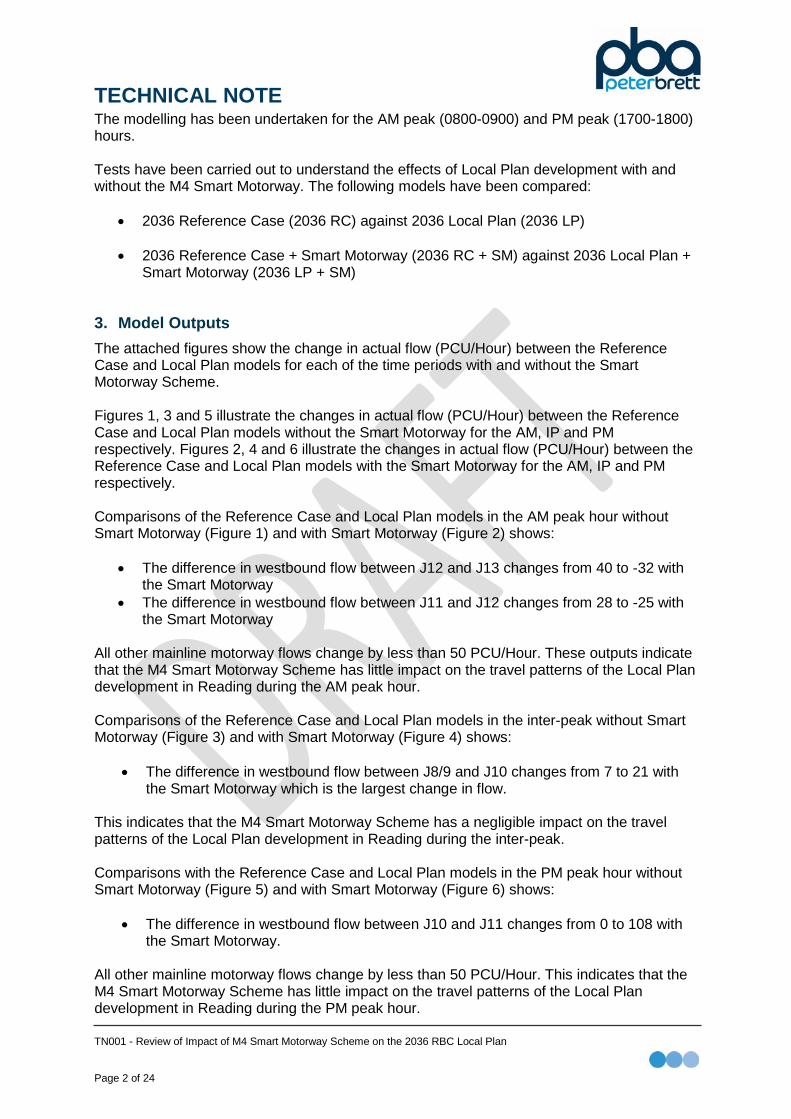
2. Methodology Highways England supplied PBA with their SATURN coding from the 2022 model prepared for testing the impact of the M4 Smart Motorway Scheme. Both existing base (Do Minimum) and proposed scheme (Do Something) SATURN models where provided to allow PBA to understand the relative capacity upgrades associated the increase in the number of lanes on the M4 between Junction 10 and Junction 12 from 3 to 4 lanes. The proposed scheme was then included in the 2036 Reading Transport Model (SATURN) network, by amending the following:
• Increasing the number of lanes from 3 to 4; • Increasing the saturation flow (6220 increased to 8340); and • Amending the speed flow curve used.
The Reading Transport Model is a highway only model, therefore the tests have been undertaken with a fixed trip matrix, which will not account for any demand responses, or mode shift to non-car modes.
DOCUMENT ISSUE RECORD Technical Note No Rev Date Prepared Checked Reviewed
(Discipline Lead) Approved
(Project Director) 28791/5536TN001 - June 2018 BH JP PG SM
28791/5536TN001v2 v2 Sept 2018 JP PG PG SM Peter Brett Associates LLP disclaims any responsibility to the Client and others in respect of any matters outside the scope of this report. This report has been prepared with reasonable skill, care and diligence within the terms of the Contract with the Client and generally in accordance with the appropriate ACE Agreement and taking account of the manpower, resources, investigations and testing devoted to it by agreement with the Client. This report is confidential to the Client and Peter Brett Associates LLP accepts no responsibility of whatsoever nature to third parties to whom this report or any part thereof is made known. Any such party relies upon the report at their own risk. © Peter Brett Associates LLP 2018 Peter Brett Associates LLP Caversham Bridge House Waterman Place, Reading Berkshire RG1 8DN T: +44 (0)118 950 0761 E: [email protected]
TECHNICAL NOTE
TN001 - Review of Impact of M4 Smart Motorway Scheme on the 2036 RBC Local Plan Page 2 of 24
The modelling has been undertaken for the AM peak (0800-0900) and PM peak (1700-1800) hours. Tests have been carried out to understand the effects of Local Plan development with and without the M4 Smart Motorway. The following models have been compared:
• 2036 Reference Case (2036 RC) against 2036 Local Plan (2036 LP)
• 2036 Reference Case + Smart Motorway (2036 RC + SM) against 2036 Local Plan + Smart Motorway (2036 LP + SM)
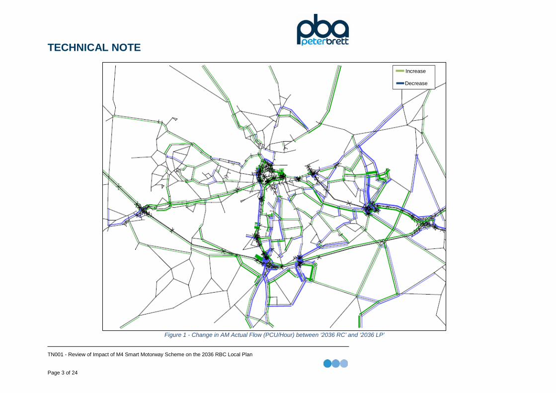
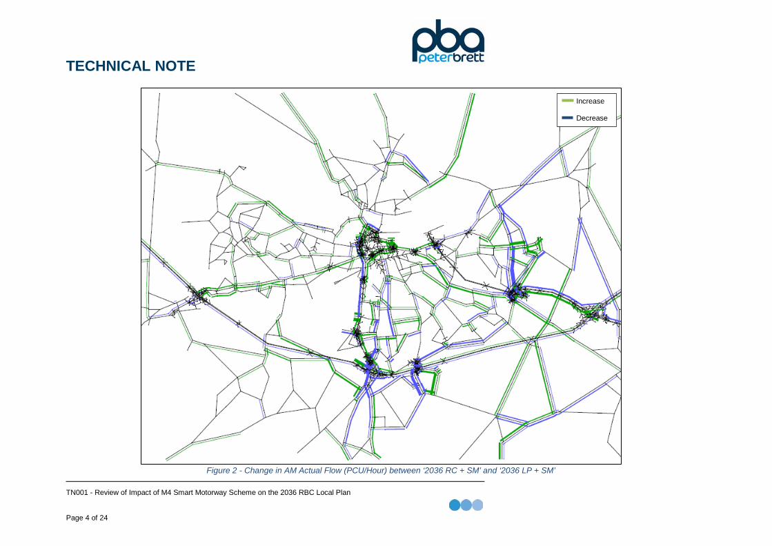
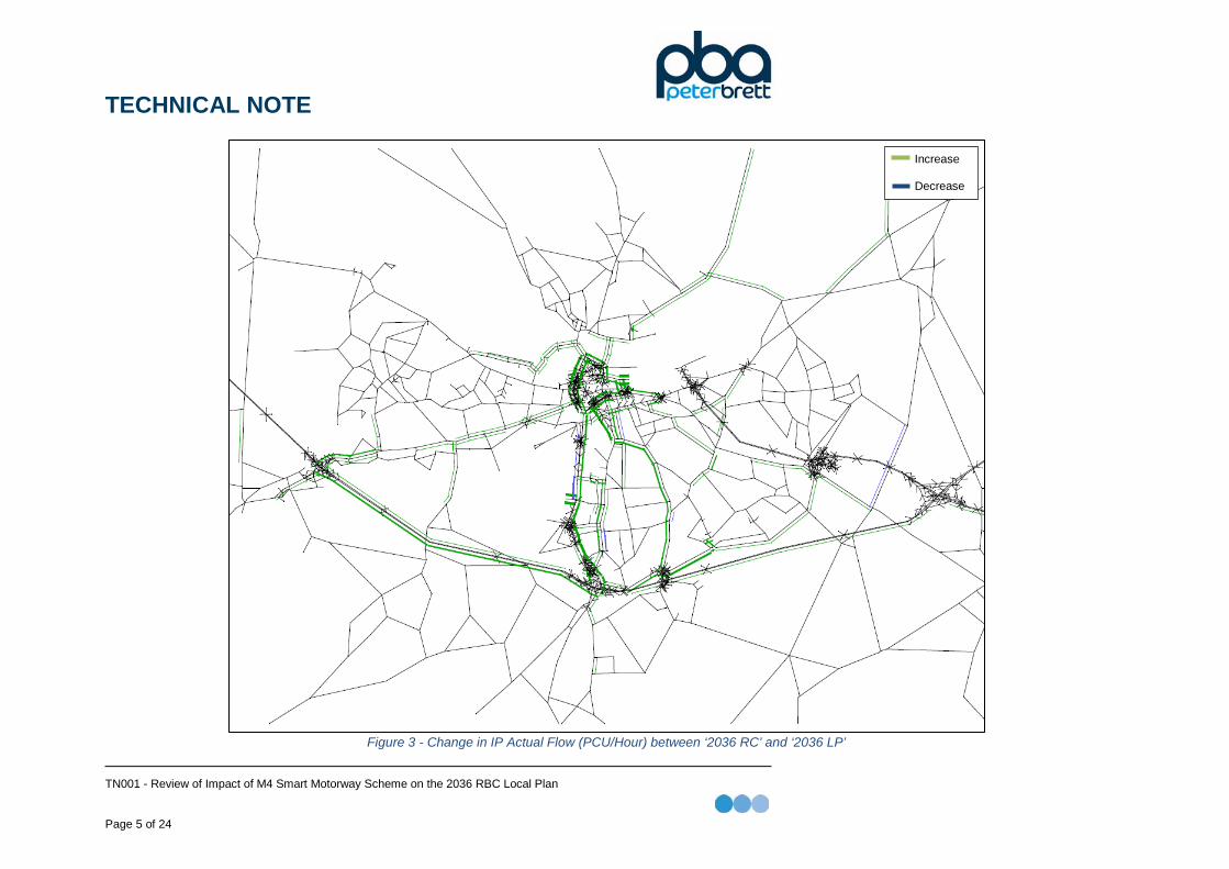
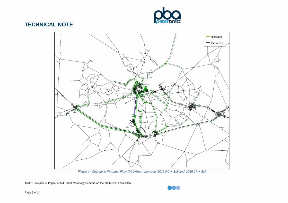
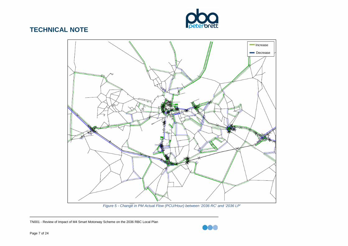
3. Model Outputs The attached figures show the change in actual flow (PCU/Hour) between the Reference Case and Local Plan models for each of the time periods with and without the Smart Motorway Scheme. Figures 1, 3 and 5 illustrate the changes in actual flow (PCU/Hour) between the Reference Case and Local Plan models without the Smart Motorway for the AM, IP and PM respectively. Figures 2, 4 and 6 illustrate the changes in actual flow (PCU/Hour) between the Reference Case and Local Plan models with the Smart Motorway for the AM, IP and PM respectively. Comparisons of the Reference Case and Local Plan models in the AM peak hour without Smart Motorway (Figure 1) and with Smart Motorway (Figure 2) shows:
• The difference in westbound flow between J12 and J13 changes from 40 to -32 with the Smart Motorway
• The difference in westbound flow between J11 and J12 changes from 28 to -25 with the Smart Motorway
All other mainline motorway flows change by less than 50 PCU/Hour. These outputs indicate that the M4 Smart Motorway Scheme has little impact on the travel patterns of the Local Plan development in Reading during the AM peak hour. Comparisons of the Reference Case and Local Plan models in the inter-peak without Smart Motorway (Figure 3) and with Smart Motorway (Figure 4) shows:
• The difference in westbound flow between J8/9 and J10 changes from 7 to 21 with the Smart Motorway which is the largest change in flow.
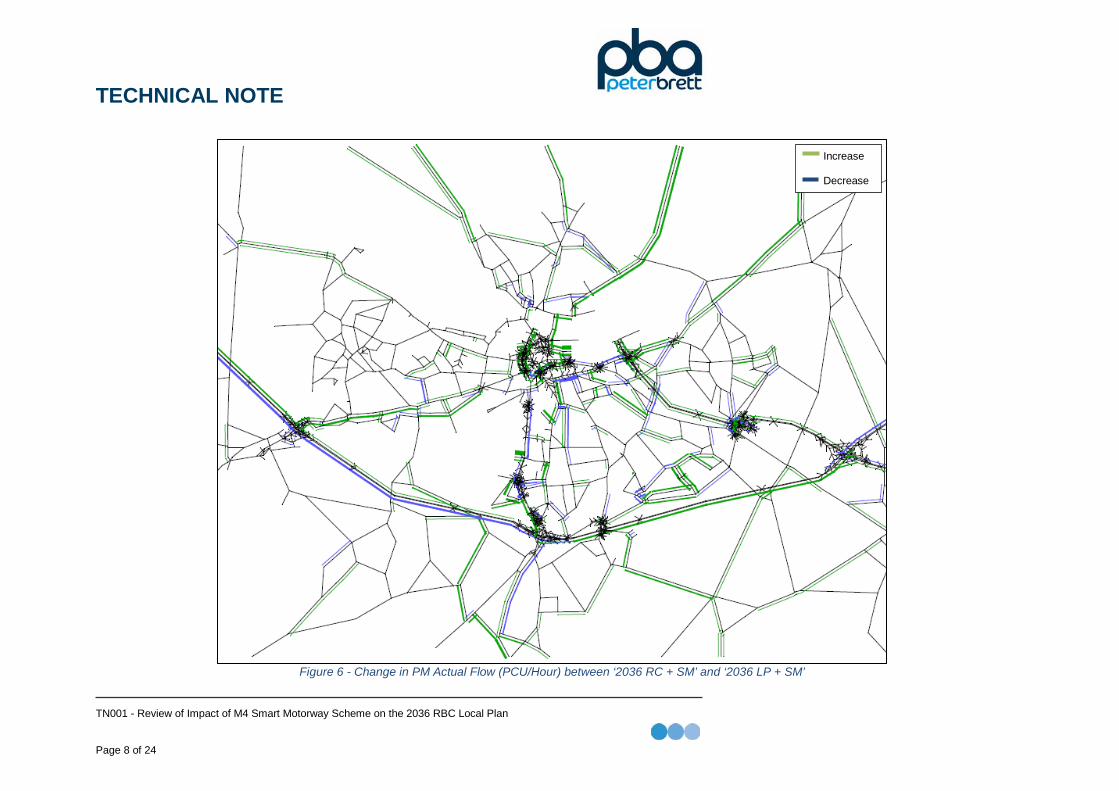
This indicates that the M4 Smart Motorway Scheme has a negligible impact on the travel patterns of the Local Plan development in Reading during the inter-peak. Comparisons with the Reference Case and Local Plan models in the PM peak hour without Smart Motorway (Figure 5) and with Smart Motorway (Figure 6) shows:
• The difference in westbound flow between J10 and J11 changes from 0 to 108 with the Smart Motorway.
All other mainline motorway flows change by less than 50 PCU/Hour. This indicates that the M4 Smart Motorway Scheme has little impact on the travel patterns of the Local Plan development in Reading during the PM peak hour.
TECHNICAL NOTE
TN001 - Review of Impact of M4 Smart Motorway Scheme on the 2036 RBC Local Plan Page 3 of 24
Figure 1 - Change in AM Actual Flow (PCU/Hour) between ‘2036 RC’ and ‘2036 LP’
Increase Decrease
TECHNICAL NOTE
TN001 - Review of Impact of M4 Smart Motorway Scheme on the 2036 RBC Local Plan Page 4 of 24
Figure 2 - Change in AM Actual Flow (PCU/Hour) between ‘2036 RC + SM’ and ‘2036 LP + SM’
Increase Decrease
TECHNICAL NOTE
TN001 - Review of Impact of M4 Smart Motorway Scheme on the 2036 RBC Local Plan Page 5 of 24
Figure 3 - Change in IP Actual Flow (PCU/Hour) between ‘2036 RC’ and ‘2036 LP’
Increase Decrease
TECHNICAL NOTE
TN001 - Review of Impact of M4 Smart Motorway Scheme on the 2036 RBC Local Plan Page 6 of 24
Figure 4 - Change in IP Actual Flow (PCU/Hour) between ‘2036 RC + SM’ and ‘2036 LP + SM’
Increase Decrease
TECHNICAL NOTE
TN001 - Review of Impact of M4 Smart Motorway Scheme on the 2036 RBC Local Plan Page 7 of 24
Figure 5 - Change in PM Actual Flow (PCU/Hour) between ‘2036 RC’ and ‘2036 LP’
Increase Decrease
TECHNICAL NOTE
TN001 - Review of Impact of M4 Smart Motorway Scheme on the 2036 RBC Local Plan Page 8 of 24
Figure 6 - Change in PM Actual Flow (PCU/Hour) between ‘2036 RC + SM’ and ‘2036 LP + SM’
Increase Decrease
TECHNICAL NOTE
TN001 - Review of Impact of M4 Smart Motorway Scheme on the 2036 RBC Local Plan Page 9 of 24
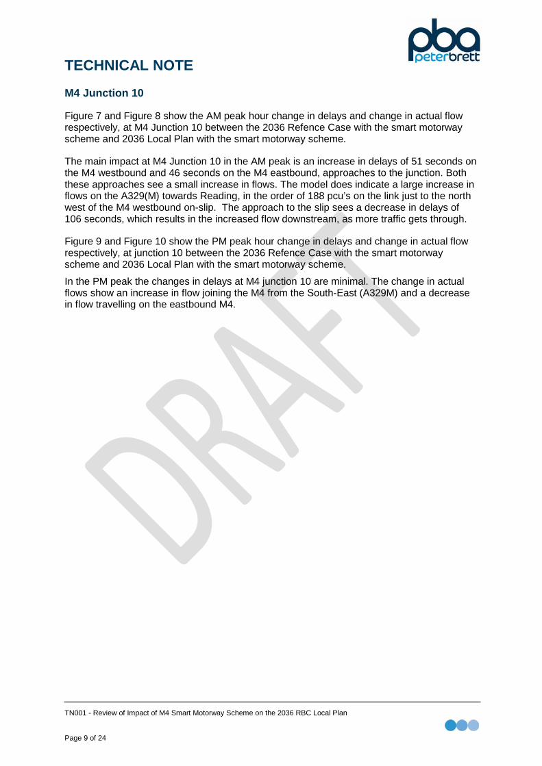
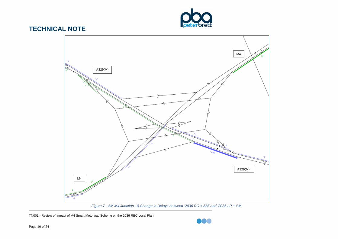
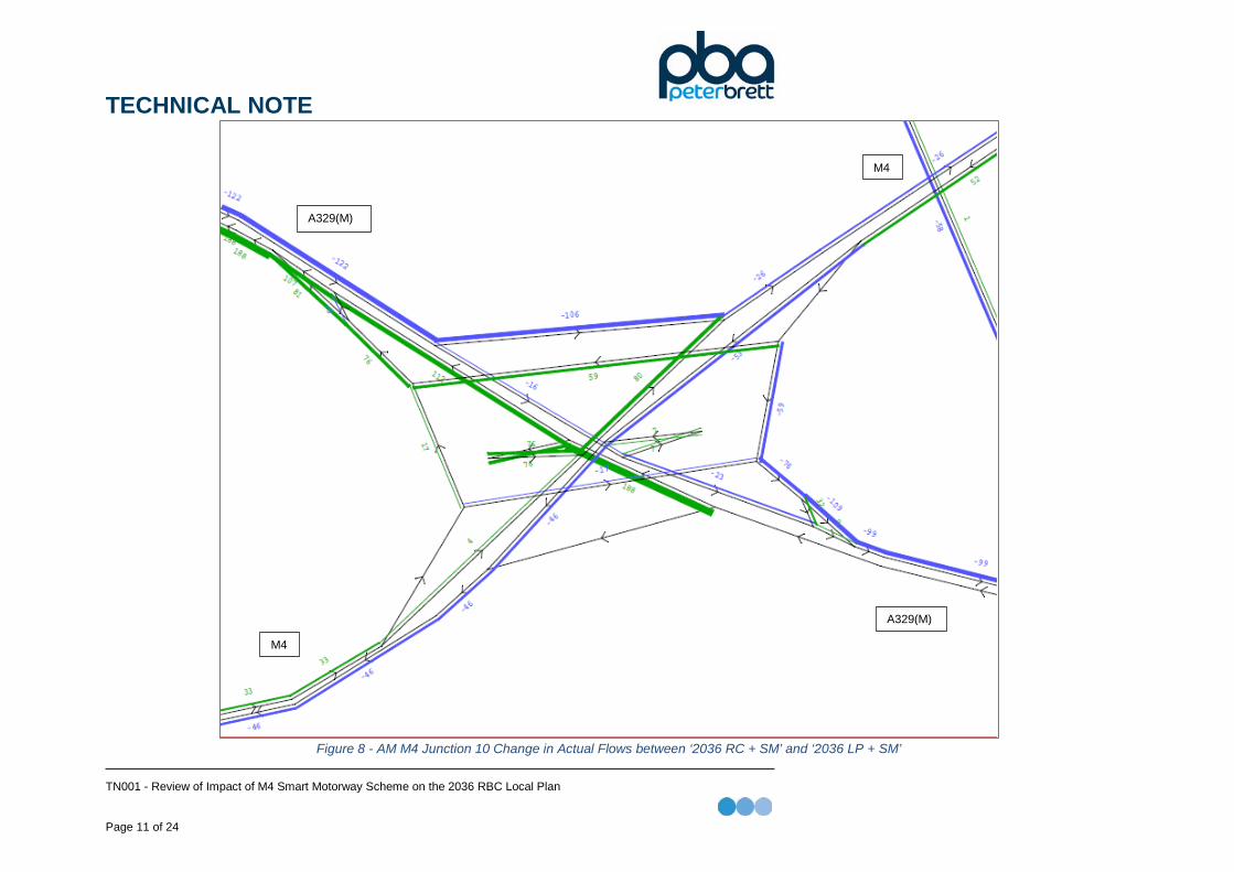
M4 Junction 10
Figure 7 and Figure 8 show the AM peak hour change in delays and change in actual flow respectively, at M4 Junction 10 between the 2036 Refence Case with the smart motorway scheme and 2036 Local Plan with the smart motorway scheme.
The main impact at M4 Junction 10 in the AM peak is an increase in delays of 51 seconds on the M4 westbound and 46 seconds on the M4 eastbound, approaches to the junction. Both these approaches see a small increase in flows. The model does indicate a large increase in flows on the A329(M) towards Reading, in the order of 188 pcu’s on the link just to the north west of the M4 westbound on-slip. The approach to the slip sees a decrease in delays of 106 seconds, which results in the increased flow downstream, as more traffic gets through.
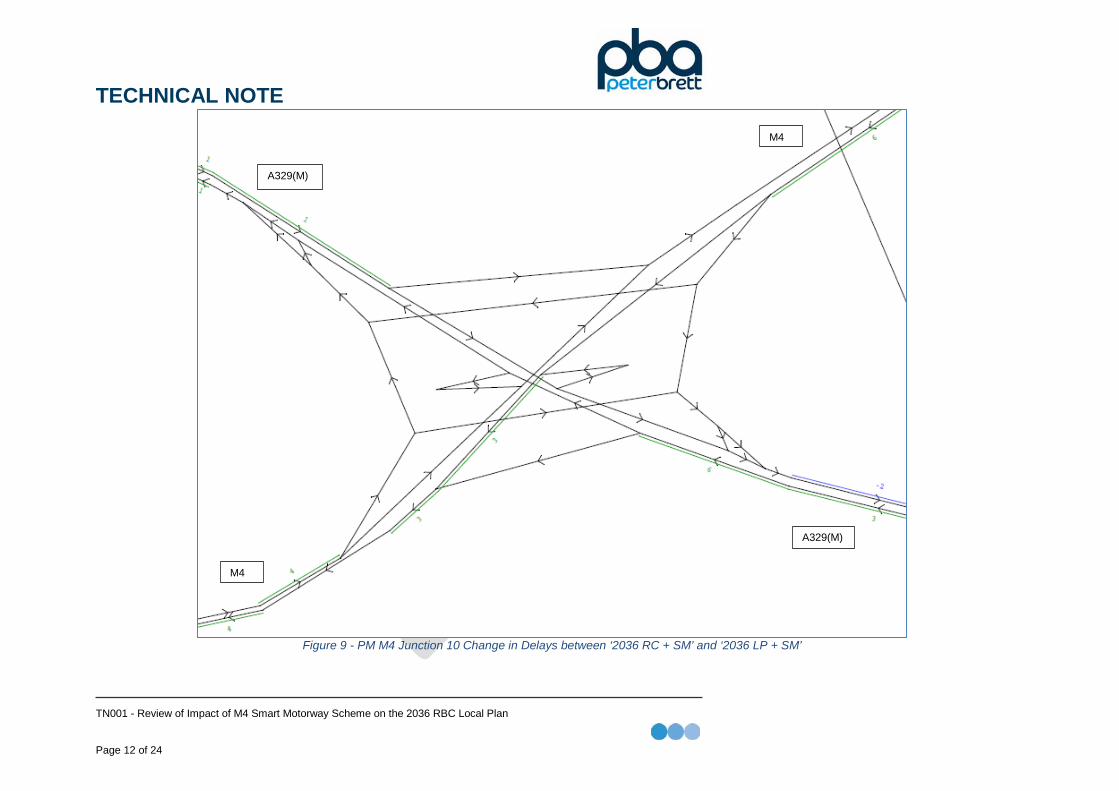
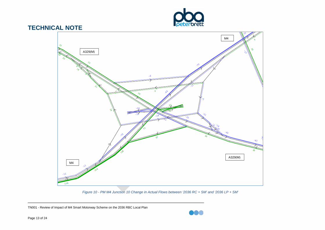
Figure 9 and Figure 10 show the PM peak hour change in delays and change in actual flow respectively, at junction 10 between the 2036 Refence Case with the smart motorway scheme and 2036 Local Plan with the smart motorway scheme.
In the PM peak the changes in delays at M4 junction 10 are minimal. The change in actual flows show an increase in flow joining the M4 from the South-East (A329M) and a decrease in flow travelling on the eastbound M4.
TECHNICAL NOTE
TN001 - Review of Impact of M4 Smart Motorway Scheme on the 2036 RBC Local Plan Page 10 of 24
Figure 7 - AM M4 Junction 10 Change in Delays between ‘2036 RC + SM’ and ‘2036 LP + SM’
M4
A329(M)
A329(M)
M4
TECHNICAL NOTE
TN001 - Review of Impact of M4 Smart Motorway Scheme on the 2036 RBC Local Plan Page 11 of 24
Figure 8 - AM M4 Junction 10 Change in Actual Flows between ‘2036 RC + SM’ and ‘2036 LP + SM’
M4
M4
A329(M)
A329(M)
TECHNICAL NOTE
TN001 - Review of Impact of M4 Smart Motorway Scheme on the 2036 RBC Local Plan Page 12 of 24
Figure 9 - PM M4 Junction 10 Change in Delays between ‘2036 RC + SM’ and ‘2036 LP + SM’
A329(M)
M4
A329(M)
M4
TECHNICAL NOTE
TN001 - Review of Impact of M4 Smart Motorway Scheme on the 2036 RBC Local Plan Page 13 of 24
Figure 10 - PM M4 Junction 10 Change in Actual Flows between ‘2036 RC + SM’ and ‘2036 LP + SM’
M4
M4 A329(M)
A329(M)
TECHNICAL NOTE
TN001 - Review of Impact of M4 Smart Motorway Scheme on the 2036 RBC Local Plan Page 14 of 24
Junction 11
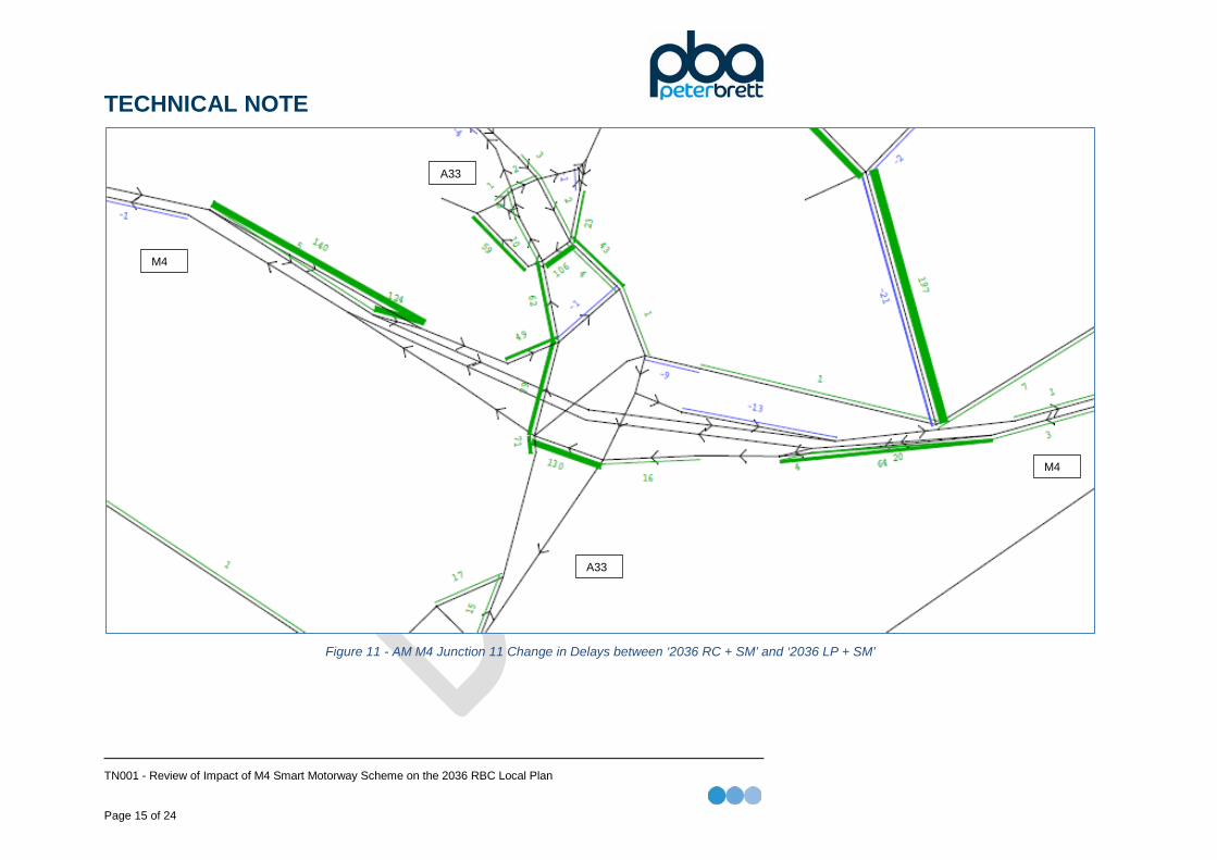
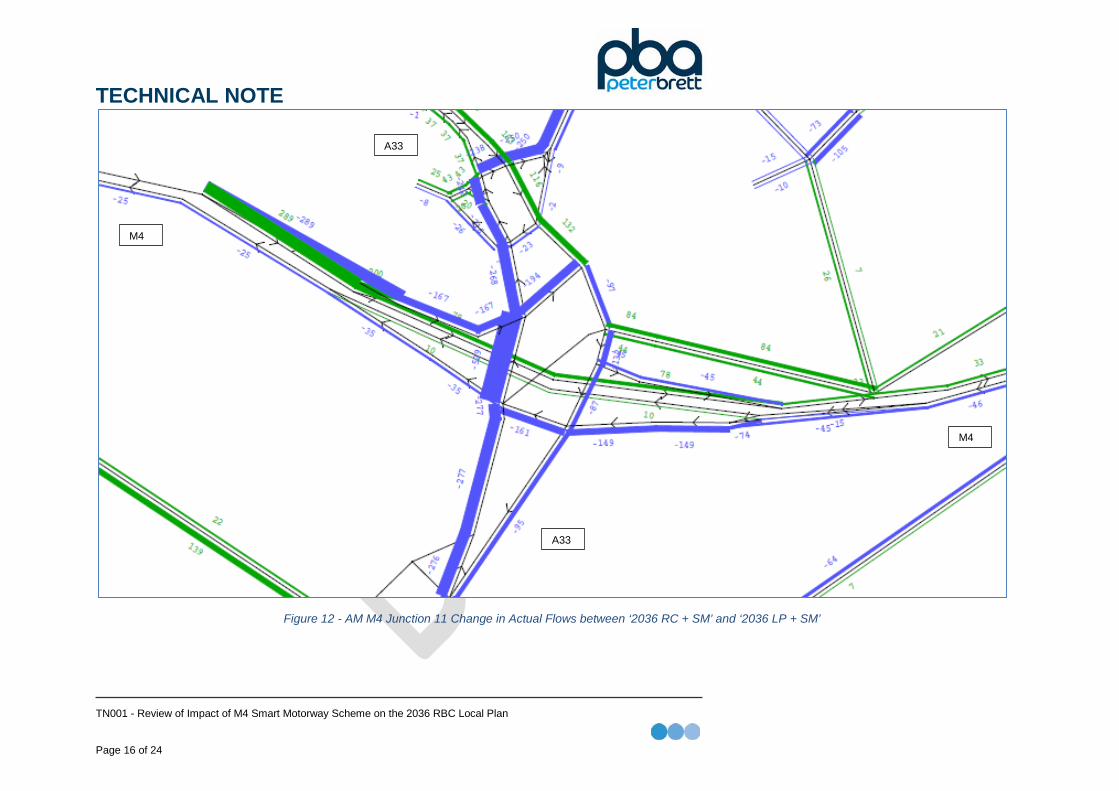
Figure 11 and Figure 12 show the AM peak hour change in delays and change in actual flow respectively, at junction 11 between the 2036 Refence Case with the smart motorway scheme and 2036 Local Plan with the smart motorway scheme.
At M4 Junction 11 in the AM peak, the LP developments add some increase delay on all approaches to the junction. The increases are on the slips and do not extend back to the motorway itself. There is an increase in actual flow entering the junction from North (A33) travelling onto the M4 eastbound. There is also a decrease in flow entering the junction from the south and from the east.
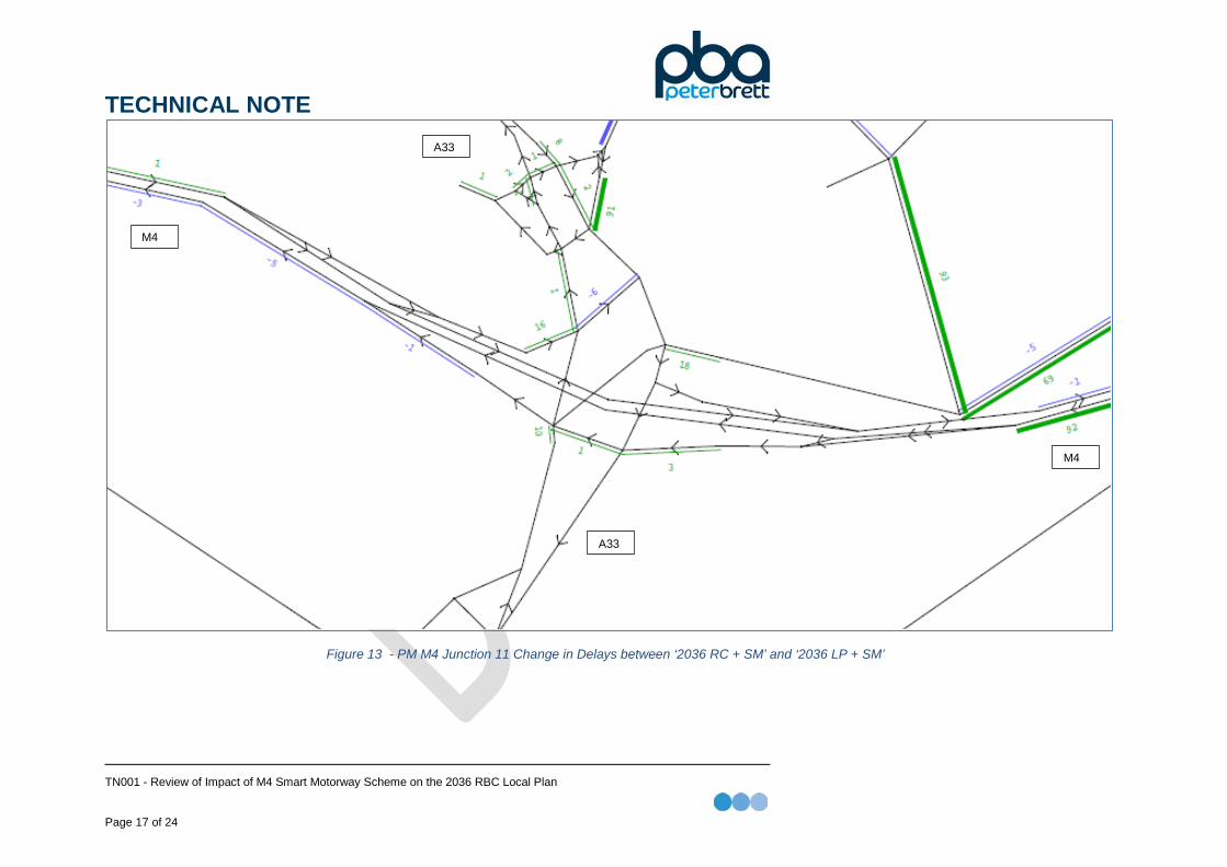
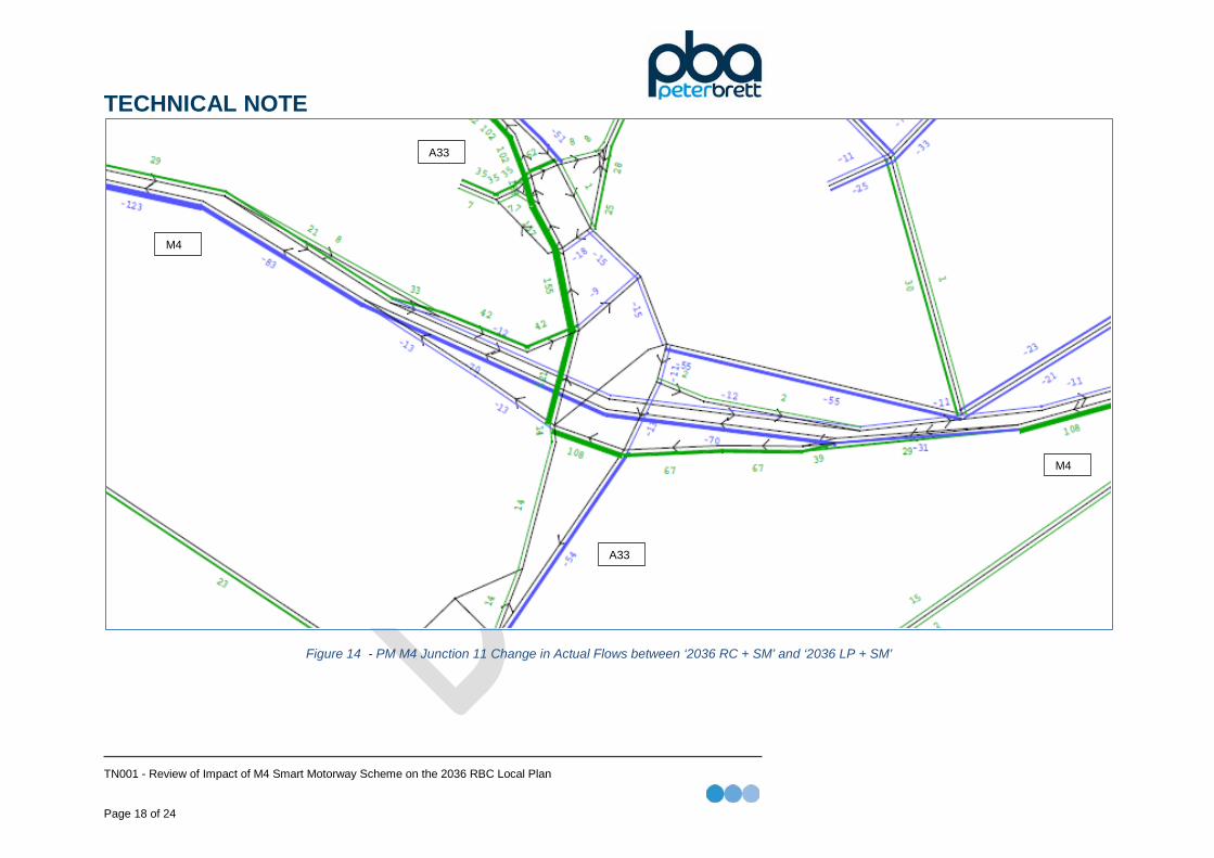
Figure 13 and Figure 14 show the PM peak hour change in delays and change in actual flow respectively, at junction 11 between the 2036 Refence Case with the smart motorway scheme and 2036 Local Plan with the smart motorway scheme.
In the PM peak the main increase in delay is on the westbound mainline, where there is an additional delay of 92 seconds, this is associated with an increased flow of 108 PCU’s. On the other arms the changes in delay are minimal. There is a minor change in the actual flow in the PM across the junction with the largest increase to traffic travelling North onto the A33.
It should be noted that due to congestion on the A33 to the north of Junction 11, there is some reassignment of traffic within the local area.
TECHNICAL NOTE
TN001 - Review of Impact of M4 Smart Motorway Scheme on the 2036 RBC Local Plan Page 15 of 24
Figure 11 - AM M4 Junction 11 Change in Delays between ‘2036 RC + SM’ and ‘2036 LP + SM’
M4
M4
A33
A33
TECHNICAL NOTE
TN001 - Review of Impact of M4 Smart Motorway Scheme on the 2036 RBC Local Plan Page 16 of 24
Figure 12 - AM M4 Junction 11 Change in Actual Flows between ‘2036 RC + SM’ and ‘2036 LP + SM’
M4
M4
A33
A33
TECHNICAL NOTE
TN001 - Review of Impact of M4 Smart Motorway Scheme on the 2036 RBC Local Plan Page 17 of 24
Figure 13 - PM M4 Junction 11 Change in Delays between ‘2036 RC + SM’ and ‘2036 LP + SM’
M4
M4
A33
A33
TECHNICAL NOTE
TN001 - Review of Impact of M4 Smart Motorway Scheme on the 2036 RBC Local Plan Page 18 of 24
Figure 14 - PM M4 Junction 11 Change in Actual Flows between ‘2036 RC + SM’ and ‘2036 LP + SM’
M4
M4
A33
A33
TECHNICAL NOTE
TN001 - Review of Impact of M4 Smart Motorway Scheme on the 2036 RBC Local Plan Page 19 of 24
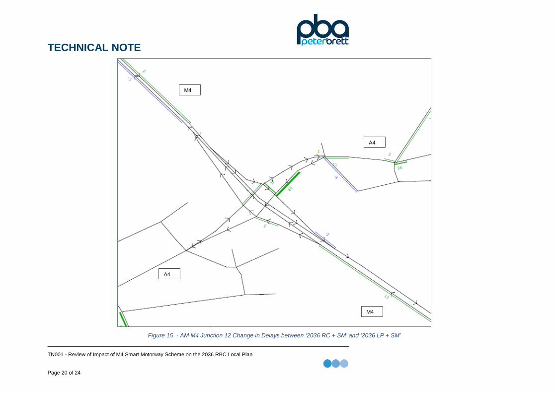
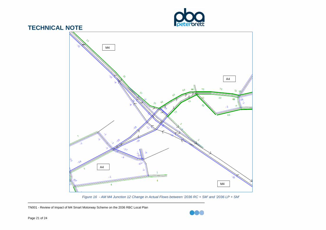
Junction 12
Figure 15 and Figure 16 show the AM peak hour change in delays and change in actual flow respectively, at junction 12 between the 2036 Reference Case with the smart motorway scheme and 2036 Local Plan with the smart motorway scheme.
At junction 12 in the AM the largest increase in delay is on the approach from the A4 westbound. On the other arms the changes are minimal. Across the junction there is minimal change on actual flow with minor increases to the North-East (Calcot) and minor decreases to the South-West (Thatcham/Newbury via Bath Road).
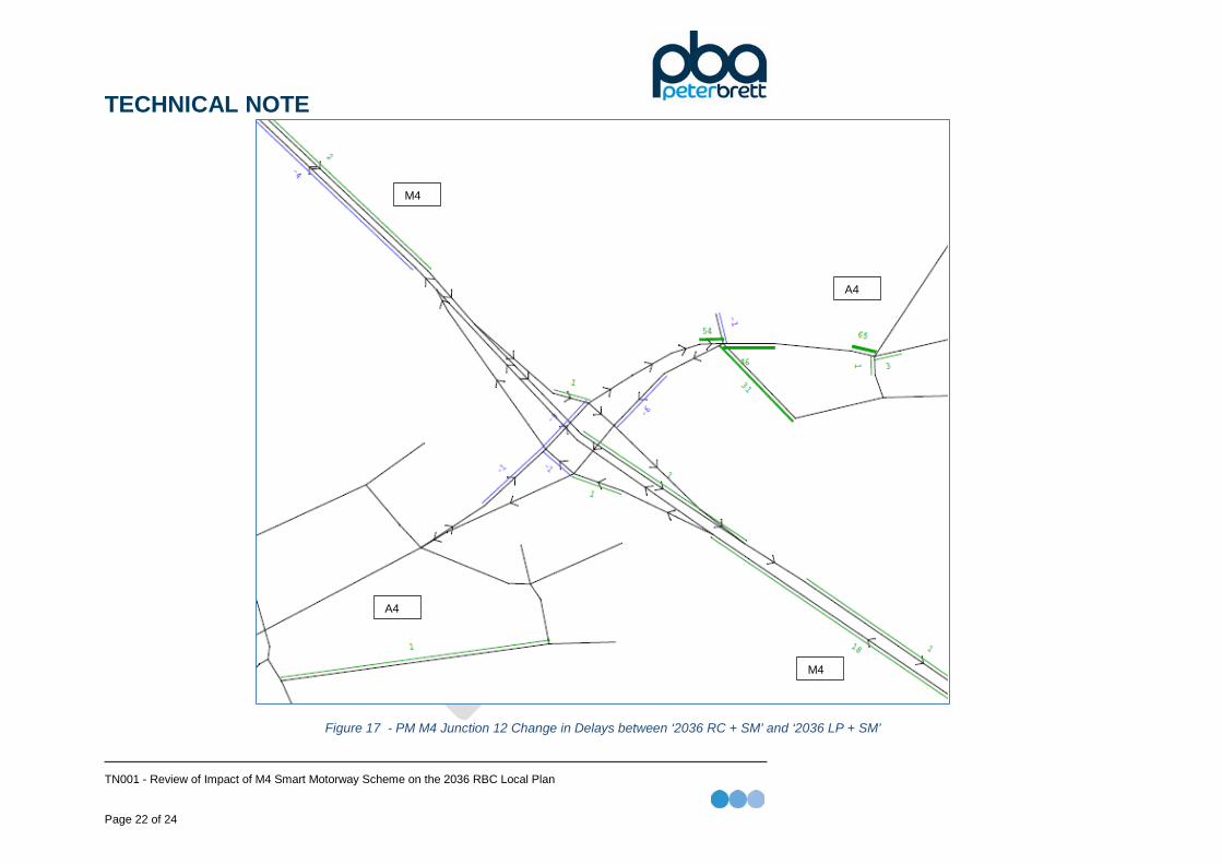
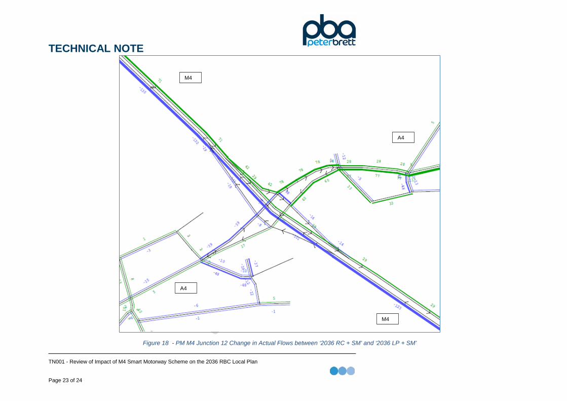
Figure 17 Figure 18 and show the PM change in delays and change in actual flow respectively, at junction 12 between the 2036 Refence Case with the smart motorway scheme and 2036 Local Plan with the smart motorway scheme.
In the PM at junction 12 the delays do not change significantly as a result of the LP development. There is minimal change in actual flow across the junction with a slight increase to flow to the North-East of the junction (Calcot) and a decrease to flow on the mainline of the M4 travelling North-Westbound (towards Newbury)
TECHNICAL NOTE
TN001 - Review of Impact of M4 Smart Motorway Scheme on the 2036 RBC Local Plan Page 20 of 24
Figure 15 - AM M4 Junction 12 Change in Delays between ‘2036 RC + SM’ and ‘2036 LP + SM’
M4
M4
A4
A4
TECHNICAL NOTE
TN001 - Review of Impact of M4 Smart Motorway Scheme on the 2036 RBC Local Plan Page 21 of 24
Figure 16 - AM M4 Junction 12 Change in Actual Flows between ‘2036 RC + SM’ and ‘2036 LP + SM’
M4
M4
A4
A4
TECHNICAL NOTE
TN001 - Review of Impact of M4 Smart Motorway Scheme on the 2036 RBC Local Plan Page 22 of 24
Figure 17 - PM M4 Junction 12 Change in Delays between ‘2036 RC + SM’ and ‘2036 LP + SM’
M4
M4
A4
A4
TECHNICAL NOTE
TN001 - Review of Impact of M4 Smart Motorway Scheme on the 2036 RBC Local Plan Page 23 of 24
Figure 18 - PM M4 Junction 12 Change in Actual Flows between ‘2036 RC + SM’ and ‘2036 LP + SM’
M4
M4
A4
A4
TECHNICAL NOTE
TN001 - Review of Impact of M4 Smart Motorway Scheme on the 2036 RBC Local Plan Page 24 of 24
4. Conclusion It should be noted that the current LP modelling does not consider any mitigation measures and as such these results should be seen as a worst-case scenario. At the three M4 motorway junctions there are increases in delay as a result of the LP developments on some arms. The actual flows show a varied change with some movements increasing and others increasing which would suggest some rerouting. .


