58
TRANSPORTATION
| Date post: | 16-Jul-2015 |
| Category: |
Engineering |
| Upload: | navneet-singh |
| View: | 252 times |
| Download: | 0 times |
TRANSPORTATION

ROAD DEVELOPMENT AND PLANNING

HISTORY OF ROAD DEVELOPMENT
• ROMAN ROADS
• FRENCH ROAD
BRITSH ROAD
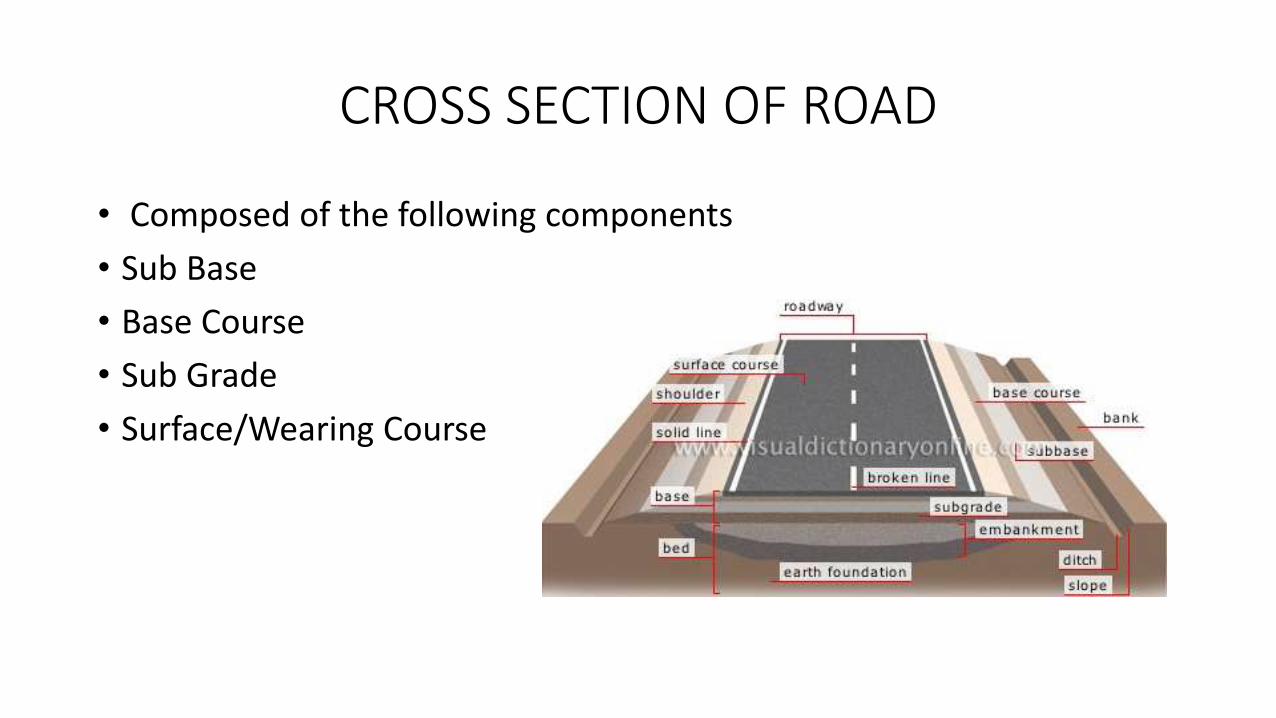
CROSS SECTION OF ROAD
• Composed of the following components
• Sub Base
• Base Course
• Sub Grade
• Surface/Wearing Course

• Sub Bases• Layer of granular material provided above subgrade.
• Enables traffic stresses to be reduced to acceptable levels in subgrade .
• Acts as a working plate form for the construction of upper pavement layers.
• Acts as a drainage layer.
• Intercept upward movement of water by capillary action.
• Acts as a separating layer b/w subgrade and road base.
• Base Course• layer immediately under the wearing surface.
• It is subjected to severe loading.

• Types of base coarse• Granular Base Course
• Macadam Base
• In-water bound Macadam
• Treated Bases
• Surface/Wearing Course• top layers of pavement which is in direct contact with the wheel
• Usually constructed of material in which bitumen is used as binder materials
• Bituminous Pavement:

Necessity of transportation planning
• Ensuring Safe, rapid, comfortable, convenient, economical, and
environmentally compatible movement of people and goods.
• Transport planning is crucial in planning sustainable developments and ensuring accessibility for all individuals.
• In the design phase of all major public amenities require significant transportation planning.
• Justify funding
• Obtain planning permission
• Environmental considerations

Classification of RoadsBased on Function:
National Highways
State Highways
Major District Roads
Other District Roads
Village Roads
Expressways
Based on Structural behavior:
Flexible pavement
Rigid Pavement
Based on Pavement
Surface:
Earth Roads
Gravel Roads
Water bound Macadam
Road
Paved Roads (bitumin or
concrete)

National highway (NH):
oThese are main roads running length and width of
the country
oConnects the National and State Capitals, major
ports and rail junctions and link up with border
roads and foreign highways
oMost are maintained by the Government of India,
others are operated under a public-private
partnership by the private sector
Based on Function

State Highways oThe arterial roads of the state connects National highways
of nearby states, state capitals, district head quarters and
important cities within the state .
oThe geometric design specification and design speed are
more or less to National highways
Major District Roads: oThese are important roads of the districts
o connects areas of production, markets, near by mainhighways and also connects each other
o Geometric specification and speed are lower than NH orSH

Other District Roads:
oThese roads connects rural areas of production, outlets to
market centre, taluk head quarters block development
centres and to other district roads.
oDesign specifications are lower than Major District Roads
Village Roads:
oThese roads serve as the feeder roads of the other
highways as well as the roads for inter village
movements.
oThey pass through rural area connecting the villages to
one another and to the nearest District Roads, State
Highways, National Highways, Railway Roads

Expressway:• These are divided highways with high geometric
standards.
• They join major points of traffic generation andconnect residential, industrial and commercial areas.
• In these roads Traffic moves at high speed with highintensity.

Based on structural behaviorFlexible Pavement:
o Has low flexural strength. External load in this pavement is largely transmitted tothe sub-grade by lateral distribution with increase in depth
o The thickness of the pavement is so designed that stresses in the sub-grade soil arekept within its bearing capacity
o Design is based on load distributing characteristics of the component layers
o Have low completion cost but repairing cost is high
o No thermal stresses are induced
Rigid pavement:
o Rigid pavements with stand more flexural stress
o Stress developed are not transmitted to the layers
o These type of pavements does not get deformed under wheel load
o Have low repairing cost but completion cost is high

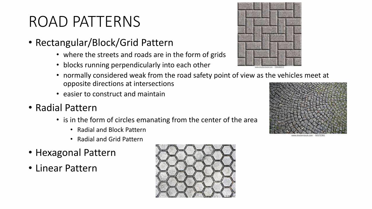
ROAD PATTERNS• Rectangular/Block/Grid Pattern
• where the streets and roads are in the form of grids
• blocks running perpendicularly into each other
• normally considered weak from the road safety point of view as the vehicles meet at opposite directions at intersections
• easier to construct and maintain
• Radial Pattern• is in the form of circles emanating from the center of the area
• Radial and Block Pattern
• Radial and Grid Pattern
• Hexagonal Pattern
• Linear Pattern
Development of Roads in India
Jayakar Committee
• 1927 Jayakar committee for Indian road development was appointed• Central government should take the proper charge considering it as a
matter of national interest• Emphasis on long term plan of 20 years.• Recommendations of periodic road conferences to discuss about road
construction and development. Lead to formation of IRC.• Imposition of additional taxation on motor transport. Includes duty on
motor spirit, vehicle taxation, license fees for vehicles plying for hire. Lead to development of CENTRAL ROAD FUND.
• Research organisation to be made for research work and development• Led to formation of Central Road Research Institute (CRRI) in 1950

Nagpur road congress 1943:
A twenty year development program for the period (1943-1963) was finalized.
It was the first attempt to prepare road developmentprogram in a planned manner.
The roads were divided into four classes: NationalHighways, State Highways, District Roads and villageRoads
The committee planned to construct 2 lakh kms of roadacross the country within 20 years.
One of the objective was that the road length should beincreased so as to give a road density of 16 kms per 100sq.km
Introduction of star and grid pattern.

Bombay road congress 1961:
It was the second 20 year road plan (1961-1981)
The total road length targeted to construct was
about 10 lakh kms
Rural roads were given specific attention. Scientific
methods of construction was proposed for the rural
roads.
They suggested that the length of the road should
be increased so as to give a road density of
32kms/100 sq.km
The construction of 1600 km of Expressways was
also then included in the plan.

Lucknow road congress 1984:
This was the third 20 year road plan (1981-2001).
It aimed at constructing a road length of 12 lakh kms bythe year 1981 resulting in a road density of 82kms/100sq.km
It aims at improving the transportation facilities in villages,towns etc. such that no part of country is farther than 50km from NH.
One of the goals contained in the plan was thatexpressways should be constructed on major trafficcorridors to provide speedy travel.
Energy conservation, environmental quality of roads androad safety measures were also given due importance inthis plan.

HIGHWAY LOCATION AND ALLIGNMENT

POINTS TO BE COVERED
• Basic Requirements of an Ideal Allignment.
• Factors Controlling the Allignment.
• Engineering Surveys for Highway Location.
• Drawings and Reports.

Requirements of an Ideal Allignment
Def?
-Easiness.
-Economics.
-Safety.
-Shortness.

Factors Controlling the Allignment
• Availability of Road Building Materials.
• Crossings.
• Geological Features.
• Land Acquisition.
• Easy Grades and Curves.
• Obligatory Points.
• Proper Drainage.
• Traffic.
• Miscellaneous.

ENGINEERING SURVEYS
• Reconnaissance Survey.
• Preliminary Survey.
• Location Survey.

RECONNAISSANCE SURVEY
• Object.
• Importance.
• Information Collected.
• Instruments.

PRELIMINARY SURVEY
• Objects.
• Importance.
• Work.
• Instruments.

LOCATION SURVEY
• Object.
• Importance.
• Work.
• Instruments.
DRAWINGS and REPORTS
• DETAILS TO BE INCLUDED IN PROJECT REPORT.
1)Introduction of the Project, its necessity and importance, geographical features of the area,etc;
2)The factors considered while deciding the finally proposed allignment.
3)Details of width, gradients, levels of controlling points, etc;

Cont……
4)Details of bridges, culverts, railway crossings, etc;
5)Details of rainfall, floods and other climatic conditions.
6)Specifications and other details of constructional standards.

Cont…..
7)Description of proposed alternative routes.
8)Conclusion giving reasons why the proposed route was finally recommended.
MAPS AND DRAWINGS REQUIRED
• DETAILED DRAWING- contours, sections, c/s, design of structures.
• INDEX MAP- topography of area symbolically.
• KEY MAP-proposed and existing roads, places to be connected.
• LAND PLANS- land acquisition details, quarries.
• PRELIMINARY SURVEY PLANS- alternative allignments for future growth.

HIGHWAY GEOMETRY DESIGN
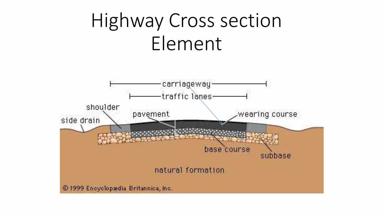
Highway Cross section Element

SIGHT DISTANCE
• The distance along road surface at which a driver has visibility of objects stationary or moving at a specified height above the carriageway.
• Criteria consider to design Highway:
• Stopping sight Distance
• Overtaking sight Distance

Stopping sight Distance
• The Distance travelled before application of breaks:
• d1= 0.695V
• Distance travelled after application of break
• d2=

Horizontal Alignment
Formula for calculation of super elevation:
µ=Coefficient of lateral friction,0.15 recommended by IRC.
Value of super elevation (e) by IRC:0.10 for area affected by snow.0.07 for all other area unaffected by snow.

Vertical Alignment
• Summit curve
• for sight distance less than length of curve
• L=
• for sight distance less than length of curve
• L=2S-
• Sag curve
• L=
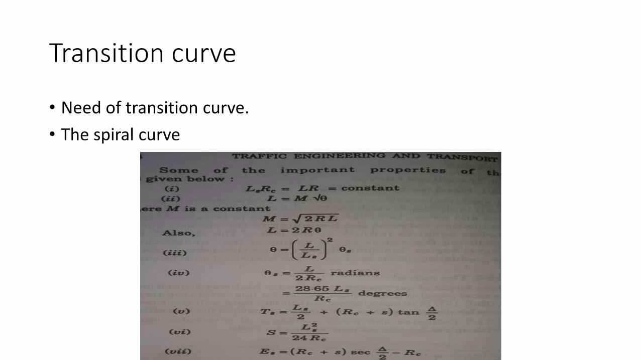
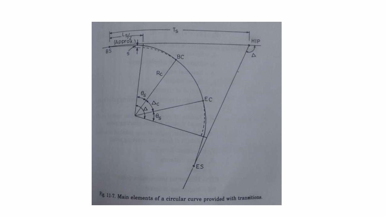
Transition curve
• Need of transition curve.
• The spiral curve

Design of Highway Pavements

• TYPES OF PAVEMENT
• FLEXIBLE PAVEMENT
• RIGID PAVEMENT

Factors affecting design of pavement
• Climate
• Environment
• Geometry
• Pavement material
• Subgrade soil
• Traffic

Design of flexible pavements
• The most commonly adopted design methods are
1] Group index (G.I.) method
2] California bearing ratio (C.B.R.) method

Group index (G.I.) method
Group index= 0.2a + 0.005ac + 0.01bd
a=portion of % of subgrade soil passing 75 micron sieve greater than 35 not exceeding 75, expressed in +ve 0 to 40
b=portion of subgrade soil passing 75 micron sieve greater than 15 and less than 55, expressed in +ve 0 to 40
c=portion of numerical liquid limit,greater than 40 less than 60, expressed in +ve 0 to 20
d=portion of numerical plasticity index,greater than 10 and less than 30, expressed in +ve 0 to 20

Design chart of G.I method

C.B.R. method
• C.B.R. of a soil gives an idea about quality of subgrade material compared to the excellent base material of crushed rock and gravel.
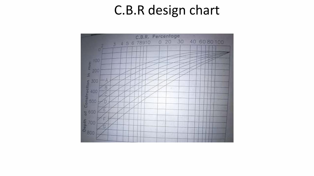
C.B.R design chart

Design of Rigid pavements
• Plain concrete
• Reinforced concrete
• Continuously reinforced concrete
• Prestressed concrete
• Factors governing design:
Traffic parameters
Environmental parameters
Foundation strength
Characteristics of concrete

Design of slab thickness:1) Critical stress conditions
a) Interior loadingb) Edge loadingc) Corner loading
2) Temperature stressesa)Wraping stressesb)Fractional stresses
3)Combination of stresses
CONSTRUCTION OF ROADS

Types of Roads
• Earth Roads
• Gravel Roads
• Water Bound macadam roads.
• Bituminous pavement
• Cement concrete pavement

Earth Roads: low cost or cheapest type of road made of locally available natural soil

Gravel Road:
o These roads are superior to earth roads.
oGravel roads does not become slippery when wetted by rain.
o The material used is crushed gravel of specified gradation and soil

Water Bound Macadam Road: broken aggregates thatare interlocked mechanically by rolling and voids filledwith screening and binding materials with the help ofwater

Bituminous Road: Construction is similar to WBM road.
Surface layer is formed with the bitumen material

Cement concrete roads

Concrete pavements joints

END


![Transportation Engineering - I - · PDF fileenough to Transportation Engineering - I nissan 3 URL: [1] INTRODUCTION TO TRANSPORTATION ENGINEERING Transportation](https://static.documents.pub/doc/80x56/5a8958357f8b9a4a268b45eb/transportation-engineering-i-to-transportation-engineering-i-nissan-3-url.jpg)


![TRANSPORTATION SERVICE AGREEMENT FOR FIRM TRANSPORTATION ... · Page 1 of 21 Transportation Service Agreement [Shipper] TRANSPORTATION SERVICE AGREEMENT FOR FIRM TRANSPORTATION OF](https://static.documents.pub/doc/80x56/5ae2498c7f8b9ad47c8ceb10/transportation-service-agreement-for-firm-transportation-1-of-21-transportation.jpg)

