N 270 —I ) Transportation Concept Report State Route 270 District 9 September 2013 Disclaimer: The information and data contained in this document are for planning purposes only and should not be relied upon for final design of any project. Any information in this Transportation Concept Report (TCR) is subject to modification as conditions change and new information is obtained. Although planning information is dynamic and continually changing, the District 9 System Planning Division makes every effort to ensure the accuracy and timeliness of the information contained in the TCR. The information in the TCR does not constitute a standard, specification, or regulation, nor is it intended to address design policies and procedures. California Department of Transportation Caltrans Improves Mobility Across California THOMAS r• HALLENBECK District 9 birector I srV’; :3 ~-c ~ 1 I Approvals: A 10/3 GAlE ROSANDER ate Acting District 9 Deputy Director Planningand Programming ‘7 $2. Date
Transcript
N
270
—I
)Transportation Concept Report
State Route 270District 9
September 2013
Disclaimer: The information and data contained in this document are for planning purposes only and should notbe relied upon for final design of any project. Any information in this Transportation Concept Report (TCR) issubject to modification as conditions change and new information is obtained. Although planning information isdynamic and continually changing, the District 9 System Planning Division makes every effort to ensure theaccuracy and timeliness of the information contained in the TCR. The information in the TCR does not constitutea standard, specification, or regulation, nor is it intended to address design policies and procedures.
California Department of TransportationCaltrans Improves Mobility Across California
THOMAS r• HALLENBECKDistrict 9 birector
I srV’;:3
~-c ~
1 I
Approvals:
A 10/3GAlE ROSANDER ateActing District 9 Deputy DirectorPlanningand Programming
‘7 $2.Date
i
TABLE OF CONTENTS
SR 270 LOCATION MAP...............................................................................................................................................1
ABOUT THE TRANSPORTATION CONCEPT REPORT ....................................................................................................2
Community Characteristics ...................................................................................................................................5
Land Use ................................................................................................................................................................5
System Characteristics ..........................................................................................................................................6
System Planning is the long-range transportation planning process for the California Department of Transportation (Caltrans). The System Planning process fulfills Caltrans’ statutory (Gov. Code §65086) responsibility as owner/operator of the State Highway System (SHS) by evaluating conditions and proposing enhancements to the SHS. Through System Planning, Caltrans focuses on developing an integrated multimodal transportation system that meets Caltrans’ goals of safety, mobility, delivery, stewardship, and service. The System Planning process is primarily composed of four parts: the District System Management Plan (DSMP), the Transportation Concept Report (TCR), the Corridor System Management Plan (CSMP), and the DSMP Project List. The district-wide DSMP is a strategic policy and planning document that focuses on maintaining, operating, managing, and developing the transportation system. The TCR is a planning document that identifies the existing and future route conditions as well as future needs for each route on the SHS. The CSMP is a complex, multi-jurisdictional planning document that identifies future needs within corridors experiencing or expected to experience high levels of congestion. The CSMP serves as a TCR for segments covered by the CSMP. The DSMP Project List is a list of planned and partially programmed transportation projects that recommends projects for funding. These System Planning products are also intended as resources for stakeholders, the public, and partner, regional, and local agencies.
STAKEHOLDER PARTICIPATION
Internal and external stakeholder participation was sought throughout the development of the State Route (SR) 270 TCR. As information for the TCR was gathered, some stakeholders were contacted for input related to their particular specializations, and to verify data sources used and data accuracy. Prior to document finalization, primary stakeholders were asked to review the document for consistency with existing plans, policies, and procedures. The process of including and working closely with stakeholders adds value to the TCR, allows for external input and ideas to be reflected in the document, increases credibility, and helps strengthen public support and trust. Stakeholders in the SR 270 planning area are community members and agencies, including, but not limited to:
• Bodie Foundation • Bodie Hills Conservation Partnership • Bridgeport Indian Colony • Bureau of Land Management, Bishop Field Office • California Department of Parks and Recreation, Bodie State Historic Park • California State Lands Commission • Caltrans Functional Units: Environmental, Local Assistance, Maintenance, Maintenance Engineering,
Planning, Program/Project Management, Right of Way, and Traffic Operations
TCR Purpose California’s State Highway System needs long range planning documents to guide the logical development of transportation systems as required by CA Gov. Code §65086 and as necessitated by the public, stakeholders, and system users. The purpose of the TCR is to evaluate current and projected conditions along the route and communicate the vision for the development of each route in each Caltrans District during a 20-25 year planning horizon. The TCR is developed with the goals of increasing safety, improving mobility, providing excellent stewardship, and meeting community and environmental needs along the corridor through integrated management of the transportation network, including the highway, transit, pedestrian, bicycle, freight, operational improvements and travel demand management components of the corridor.
Page | 3
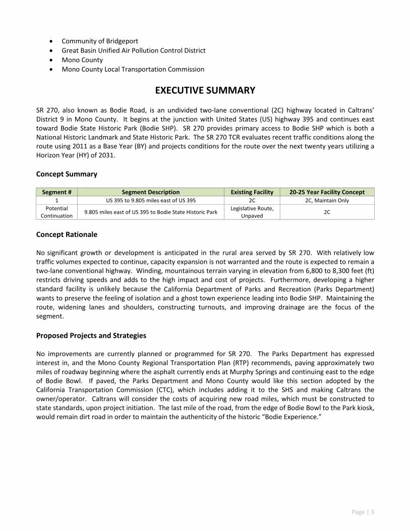
• Community of Bridgeport • Great Basin Unified Air Pollution Control District • Mono County • Mono County Local Transportation Commission
EXECUTIVE SUMMARY
SR 270, also known as Bodie Road, is an undivided two-lane conventional (2C) highway located in Caltrans’ District 9 in Mono County. It begins at the junction with United States (US) highway 395 and continues east toward Bodie State Historic Park (Bodie SHP). SR 270 provides primary access to Bodie SHP which is both a National Historic Landmark and State Historic Park. The SR 270 TCR evaluates recent traffic conditions along the route using 2011 as a Base Year (BY) and projects conditions for the route over the next twenty years utilizing a Horizon Year (HY) of 2031. Concept Summary
Segment # Segment Description Existing Facility 20-25 Year Facility Concept 1 US 395 to 9.805 miles east of US 395 2C 2C, Maintain Only
Potential Continuation 9.805 miles east of US 395 to Bodie State Historic Park Legislative Route,
Unpaved 2C
Concept Rationale No significant growth or development is anticipated in the rural area served by SR 270. With relatively low traffic volumes expected to continue, capacity expansion is not warranted and the route is expected to remain a two-lane conventional highway. Winding, mountainous terrain varying in elevation from 6,800 to 8,300 feet (ft) restricts driving speeds and adds to the high impact and cost of projects. Furthermore, developing a higher standard facility is unlikely because the California Department of Parks and Recreation (Parks Department) wants to preserve the feeling of isolation and a ghost town experience leading into Bodie SHP. Maintaining the route, widening lanes and shoulders, constructing turnouts, and improving drainage are the focus of the segment. Proposed Projects and Strategies No improvements are currently planned or programmed for SR 270. The Parks Department has expressed interest in, and the Mono County Regional Transportation Plan (RTP) recommends, paving approximately two miles of roadway beginning where the asphalt currently ends at Murphy Springs and continuing east to the edge of Bodie Bowl. If paved, the Parks Department and Mono County would like this section adopted by the California Transportation Commission (CTC), which includes adding it to the SHS and making Caltrans the owner/operator. Caltrans will consider the costs of acquiring new road miles, which must be constructed to state standards, upon project initiation. The last mile of the road, from the edge of Bodie Bowl to the Park kiosk, would remain dirt road in order to maintain the authenticity of the historic “Bodie Experience.”
1 US 395 to 9.805 miles east of US 395 MNO_270_0.000 MNO_270_9.805 Potential
Continuation 9.805 miles east of US 395 to Bodie State Historic Park MNO_270_9.805 MNO_270_13.300
ROUTE DESCRIPTION SR 270 is located in northeastern Mono County and is defined by the county as a scenic highway. It begins at the junction with US 395 (PM 0.000), 6.287 miles north of Conway Summit in the Bodie Hills, and extends east to its terminus at 9.805 miles from US 395 (PM 9.805). In 1970, the California State Legislature passed an assembly bill adding SR 270, from US 395 to Bodie SHP, to the SHS. In 1978, the CTC adopted SR 270 from US 395 to 9.805 miles east of US 395 (Segment 1). Segment 1 is a paved road and is maintained by Caltrans District 9. Due to low traffic volumes and its functional classification, the Maintenance Service Level (MSL) of the route is 3. MSL 3 indicates a route with the lowest maintenance priority. The potential continuation of SR 270 from PM 9.805 to
Page | 5
PM 13.300 is currently unpaved. For the purpose of this TCR and unless otherwise stated, SR 270 refers only to the CTC adopted and Caltrans maintained highway from PM 0.000 to PM 9.805. SR 270 is functionally classified as a Major Collector, providing access to Bodie SHP, recreational opportunities, and sheep ranching lands. Services such as food, lodging, and gasoline, are not available along SR 270 or in Bodie. The route is closed seasonally to automobiles, generally from November through May, because snow is not removed. During the road closure period, the park is accessible only by skis, snowshoes, or snowmobiles. In contrast, during the peak season of June to October, recreational traffic becomes prevalent along the route. In 2012, Bodie SHP received over 114,000 visitors, an increase from 98,000 the previous year. The park employs five people who live onsite year-round. The addition of seasonal employees brings the resident number to approximately twenty. SR 270 is shared by all permissible modes of transportation. The highway is designated as a California Legal Advisory Route from the SR 270/US 395 junction (PM 0.000) to the end of the pavement (PM 9.805). Trucks with a kingpin-to-rear-axle distance over 30 ft are advised not to travel; buses and motor homes over 40 ft in length are prohibited. Route Designation and Characteristics
Segment # 1
Freeway and Expressway System No National Highway System No Strategic Highway Network No State Scenic Highway No Interregional Road System No High Emphasis Route No Focus Route No Federal Functional Classification Major Collector Goods Movement Route No Truck Designation CA Legal Advisory Rural/Urban/Urbanized Rural Regional Transportation Planning Agency Mono County Local Transportation Commission County Transportation Commission Mono County Local Transportation Commission Local Agency Mono County Tribes Bridgeport Indian Colony Air District Great Basin Unified Air Pollution Control District Terrain Mountainous, Winding
COMMUNITY CHARACTERISTICS There are no communities within the vicinity of SR 270. LAND USE
Segment # Place Type 1 Rural, Majority is Publicly Owned
Adjacent to SR 270, land use designation is authorized for agriculture, resource management, and rural resort. The land is owned by the Bureau of Land Management (BLM), the Parks Department, Mono County, State of California Lands Commission, and some private landowners. The remaining structures and remnants of the
Page | 6
legendary boomtown and historic mining region of Bodie create the Bodie Experience; hence, the park is preserved and managed in a state of arrested decay. The area is a major recreational attraction in Mono County and provides visitors a unique sense of frontier life in the 1880s. Preserving the Bodie Experience is of upmost importance to the Parks Department, the BLM, Mono County, and various interest groups. The Mono County General Plan, Land Use Element, from 2012, outlines many objectives and policies geared toward the goal of protecting and enhancing the Bodie Hills Planning Area resources that complement the Bodie Experience. The plan states that developments must be compatible with the existing cultural, historic and natural values of the area. With regard to transportation on SR 270, the plan calls upon Caltrans and Mono County to develop scenic turnouts with interpretive information. Agriculture, resource management activities, and rural resort uses on private lands are allowed if the activity does not detract from the Bodie Experience. SR 270 lies within the Bodie Hills Management Area as designated by the BLM. According to the BLM, this area has significant mineral, wildlife, riparian, livestock grazing, cultural, and recreational value (U.S. Department of the Interior, Bureau of Land Management, Bishop Resource Management Plan and Environmental Impact Statement, August 1991). The BLM’s Resource Management Plan (RMP) reflects the agency’s desire to enhance dispersed recreation opportunities such as off-highway vehicle touring, primitive camping, mountain biking, sightseeing, and environmental interpretation. Subject to existing law, mining on valid, existing claims on public lands is allowed.
SYSTEM CHARACTERISTICS SR 270 is a two-lane conventional highway comprised of 9.805 paved centerline miles with a speed limit of 55 miles per hour (mph). Neither capacity increasing nor facility expansion projects are envisioned within the 20 year capital facility concept. Paved and unpaved turnouts and aprons exist along the highway while all access roads are unpaved.
Segment # 1
Existing Facility Facility Type Conventional General Purpose Lanes 2 Lane Miles 19.61 Centerline Miles 9.805 Shoulder Width 0-2 ft, paved Median Width 0 Lane Width 10-12 ft Passing Lanes 0 Truck Climbing Lanes 0
Distressed Pavement 0% Current Right-of-way (ROW) 60 – 100 ft, by prescriptive rights and R.S. 2477
Concept Facility Facility Type C General Purpose Lanes 2 Lane Miles 19.61 Centerline Miles 9.805 Shoulder Width 4 ft, paved Median Width 0 Lane Width 12 ft Passing Lanes 0 Truck Climbing Lanes 0
Page | 7
BICYCLE FACILITY There are no designated bicycle routes on SR 270 and a parallel facility is not present. The Bodie SHP Supervising Ranger, Tom Gunther, estimates an average of ten bicyclists per summer season utilize the route. Bicyclists share the road with automotive traffic due to shoulders being variable in width. To help fulfill the objective of providing for multimodal travel into Bodie, the Mono County RTP lists development of a Bodie bike route loop along SR 270, Cottonwood Canyon Road, SR 167 and US 395 as an action item. The bike route loop should consist of a shared roadway with a minimum of 4 ft of paved shoulder. Also, it is suggested that bicycle racks and a bicycle parking area at the main parking lot/restroom area of Bodie SHP be provided.
PEDESTRIAN FACILITY Pedestrian traffic on SR 270 is minimal and pedestrian specific facilities do not exist. Due to variable width shoulders, pedestrians may utilize the paved shoulder, the unpaved shoulder, and/or the roadway.
Segm
ent #
Post
Mile
Loca
tion
Desc
riptio
n
Pede
stria
n Ac
cess
Pro
hibi
ted
Side
wal
k Pr
esen
t
Cros
sing
Dis
tanc
e
Fac
ility
Des
crip
tion
1 0.000-9.805 US 395 to 9.805 miles east of US 395 No No 21–40 ft Pedestrians use paved and unpaved shoulders of
varying widths, and/or the roadway
Segm
ent #
State Bicycle Facility Parallel Bicycle Facility
Post
Mile
Loca
tion
Desc
riptio
n
Bicy
cle
Acce
ss P
rohi
bite
d
Faci
lity
Type
Out
side
Pav
ed S
houl
der W
idth
Faci
lity
Desc
riptio
n
Post
ed S
peed
Lim
it
Para
llel F
acili
ty P
rese
nt
1 0.000-9.805
US 395 to 9.805 miles
east of US 395 No No Bikeway
Designation 0-2 ft Topography is winding, mountainous terrain. Bicyclists share the road with
automotive traffic.
55 mph No
Page | 8
ENVIRONMENTAL CONSIDERATIONS The purpose of this environmental scan is to identify environmental factors that may need future analysis in the project development process. This information does not represent all possible environmental considerations that may exist within the area surrounding the route and any SR 270 project being considered for programming would require environmental clearance in compliance with all federal, state, and local environmental laws and regulations. The environmental factors identified in the environmental scan have been scaled (high=red, medium=yellow, or low=green) by district staff based on the probability of encountering such environmental issues. BLM issued a decision record designating the Bodie Bowl as an Area of Critical Environmental Concern (ACEC). An ACEC Plan accompanies such designation and provides guidelines for “limits of acceptable change.” Any project proposed within the Bodie Bowl is required to meet strict standards and specific criteria. The following environmental factors were included in the scan:
• Section 4(f) Land: SR 270 is the only paved road accessing Bodie SHP which is a publicly owned state park with historic significance.
• Cultural Resources: There are several known prehistoric and historic archaeological sites along SR 270;
therefore, the appropriate level of archaeological and historical studies, including Native American consultation, will be required for any project along this route including the assessment and possible mitigation to all cultural resource impacts. According to the BLM’s RMP, cultural inventory State Historic Preservation Officer (SHPO) review processes would be followed in accordance with Section 106 of the National Historic Preservation Act of 1966.
• Visual Aesthetics: Mono County, the Parks Department, and various interest groups seek to preserve the existing character of the route so all transportation projects within the corridor should consider maintaining the Bodie Experience as they are developed.
• Air Quality: Mono County is part of the Great Basin Valleys Air Basin under the stewardship of the Great Basin Unified Air Pollution Control District. Mono County is identified as an area of unclassifiable/attainment for Ozone, Particulate Matter (PM) 2.5, and Carbon Monoxide. With regard to PM 10, SR 270 lies within two different identification areas, unclassifiable and nonattainment. During windy conditions, PM 10 levels spike on a short term, episodic basis when dust from the exposed Mono Lake bed produces high concentrations of particulate matter in the air.
• Waters and Wetlands: Within the SR 270 corridor, Clearwater Creek flows about half of the length of the route and is on the 303(d) list of impaired waters. However, according to Lahontan Regional Water Quality Control Board, Clearwater Creek will be delisted in 2014. While there are several waters located along the route, Clearwater Creek is the only named system.
• Special Status Species: The following species are within a 2000 ft wide corridor centered along SR 270: o Greater sage-grouse, Centrocercus urophasianus; Species of Special Concern (SSC)/California
Department of Fish and Wildlife (CDFW), Candidate/United States Fish & Wildlife Service (USFWS)
o Mono County phacelia, Phacelia monoensis; Rare Plant Rank 1B.1, seriously endangered/California Native Plant Society (CNPS)
For the 2011 BY, Segment 1 carried 480 Annual Average Daily Trips (AADT), 5.65% of which were associated with truck travel. Because SR 270 is closed for several months each year due to lack of snow removal, AADT calculation is not done in a standard manner. The AADT is based only on the time it is open, not the full year. Months in which the road is closed are not included in the calculation. The segment currently operates at Level of Service (LOS) A. LOS degradation is not anticipated; hence, capacity increasing projects are not warranted or proposed for the facility through the HY of 2031. Future safety and operational improvements may be pursued but will have to take into account potential scenic and/or environmental impacts.
Corridor Performance table displays 2011 Base Year (BY) traffic data and estimates a Horizon Year (HY) of 2031.
Segment # 1
Basic System Operations AADT (BY) 480
AADT (HY) 480
AADT: Growth Rate/Year 0%
LOS Method Highway Capacity Manual (HCM)
LOS (BY) A
LOS (HY) A
LOS Concept C
Vehicle Miles Traveled (VMT) (BY) 4706
VMT (HY) 4706
Truck Traffic Total Average Annual Daily Truck Traffic (AADTT) (BY) 27
Total Average Annual Daily Truck Traffic (AADTT) (HY) 27
Total Trucks (% of AADT) (BY) 5.65%
Total Trucks (% of AADT)(HY) 5.65%
5+ Axle Average Annual Daily Truck Traffic (AADTT) (BY) 0
Peak Hour Traffic Data Peak Period Length 1
Peak Hour Direction East
Peak Hour Time of Day PM
Peak Hour Directional Split (BY) 50/50
Peak Hour Directional Split (HY) 50/50
Peak Hour VMT (BY) 647
Peak Hour VMT (HY) 647
Page | 10
KEY CORRIDOR ISSUES
For Segment 1, Caltrans will consider route improvements, such as, widening lanes and shoulders, constructing turnouts, and improving drainage. Mono County’s objectives for the Bodie Hills area are to improve existing transportation and access for multiple modes by enhancing safe, convenient travel. Their objectives for Segment 1 and the unpaved portion of Bodie Road include: reducing washboard roadbed and dust problems; providing for alternative modes of travel such as pedestrian, bicycle, and/or equestrian; installing transportation amenities such as scenic turnouts, interpretive kiosks, and a common signing program (informational, educational, and directional); and maintaining a road system that serves both public and private landowners.
CORRIDOR CONCEPT
CONCEPT RATIONALE No significant growth or development is anticipated in the rural area served by SR 270. With relatively low traffic volumes expected to continue, capacity expansion is not warranted and the route is expected to remain a two-lane conventional highway. Winding, mountainous terrain varying in elevation from 6,800 to 8,300 ft restricts driving speeds and adds to the high impact and cost of projects. Furthermore, developing a higher standard facility is unlikely because the Parks Department wants to preserve the feeling of isolation and a ghost town experience leading into Bodie SHP. Maintaining the route, widening lanes and shoulders, constructing turnouts, and improving drainage are the focus of the segment. PLANNED AND PROGRAMMED PROJECTS AND STRATEGIES Currently, there are no planned or programmed projects identified for SR 270. PROJECTS AND STRATEGIES TO ACHIEVE CONCEPT
US 395 to 9.805 miles east of US 395 Caltrans District 9 Maintenance
and Operations Long Term
1 Widen lanes to twelve feet US 395 to 9.805 miles east of US 395 Caltrans District 9 Maintenance
and Operations Long Term
1 Paved turnouts Various Caltrans District 9 Operations Long Term
1 Culvert extensions Various Caltrans District 9 Maintenance Long Term
1 and Potential
Continuation
Establish a trail system in the Bodie Hills that provides for
equestrian, cycling, and pedestrian use
SR 270 and other locations
Mono County RTP
Multimodal Use Long Term
Potential Continuation Pave Bodie Road
From Murphy Springs to the edge of
Bodie Bowl
Mono County RTP
Maintenance and Operational
Enhancement Long Term
1 Scenic turnouts with interpretive displays Various
Mono County RTP
Transportation Enhancement Long Term
1 Bodie bike route loop SR 270, Cottonwood Canyon Road, SR 167
and US 395
Mono County RTP Multimodal Use Long Term
Page | 11
APPENDIX
APPENDIX A GLOSSARY OF TERMS AND ACRONYMS
Acronyms 2C – Two-Lane Conventional Highway AADT – Annual Average Daily Traffic ACEC – Area of Critical Environmental Concern Bodie SHP – Bodie State Historic Park BLM – Bureau of Land Management BY – Base Year Caltrans – California Department of Transportation CDFW – California Department of Fish and Wildlife CNPS – California Native Plant Society CNDDB – California Natural Diversity Database FHWA – Federal Highway Administration HCM – Highway Capacity Manual HY – Horizon Year LOS – Level of Service MNO – Mono County MPH – Miles Per Hour MSL – Maintenance Service Level N/A – Not Applicable Parks Department – California Department of Parks and Recreation PM – Post Mile or Particulate Matter R/W – Right-of-Way RMP – Resource Management Plan RTP – Regional Transportation Plan SHPO – State Historic Preservation Officer SHS – State Highway System SR – State Route SSC – Species of Special Concern TCR – Transportation Concept Report US 395 – United States highway 395 USFWS – United States Fish & Wildlife Service VMT – Vehicle Miles Traveled Definitions Annual Average Daily Traffic (AADT) – The total volume for the year divided by 365 days. The traffic count year is from October 1st through September 30th. Traffic counting is generally performed by electronic counting instruments moved from location to location throughout the state in a program of continuous traffic count sampling. The resulting counts are adjusted to an estimate of annual average daily traffic by compensating for seasonal influence, weekly variation and other variables which may be present. AADT is necessary for presenting a statewide picture of traffic flow, evaluating traffic trends, computing accident rates, planning and designing highways and other purposes.
Page | 12
Base Year (BY) – The year that the most current data is available to the districts. Capacity – The maximum sustainable hourly flow rate at which persons or vehicles reasonably can be expected to traverse a point or a uniform section of a lane or roadway during a given time period under prevailing roadway, environmental, traffic, and control conditions. Capital Facility Concept – The 20-25 year vision of future development on the route to the capital facility. The capital facility can include capacity increasing, state highway, bicycle/pedestrian/transit facility, grade separation, and new managed lanes. Concept LOS – The minimum acceptable LOS over the next 20-25 years. Conceptual Project – A conceptual improvement or action is a project that is needed to maintain mobility or serve multimodal users, but is not currently included in a financially constrained plan and is not currently programmed. It could be included in a general plan or in the unconstrained section of a long-term plan. Conventional Highway – A highway generally without controlled access. Grade separations at intersections or access control may be used at spot locations when justified. Facility Concept – Describes the facility and strategies that may be needed within 20-25 years. This can include capacity increasing, state highway, bicycle/pedestrian/transit facility, non-capacity increasing operational improvements, new managed lanes, conversion of existing managed lanes to another managed lane type or characteristic, TMS field elements, and transportation demand/incident management. Facility Type – The facility type describes the state highway facility type. The facility could be freeway, expressway, conventional, or one-way city street. Functional Classification – Guided by federal legislation, refers to a process by which streets and highways are grouped into classes or systems according to the character of the service that is provided, i.e. Principal and Minor Arterial Roads, Collector Roads, and Local Roads. Horizon Year (HY) – The year that the future (20-25 years) data is based on. Level of Service (LOS) – A qualitative measure describing operational conditions within a traffic stream and their perception by motorists. A LOS definition generally describes these conditions in terms of speed, travel time, freedom to maneuver, traffic interruption, comfort, and convenience. Six levels of LOS can generally be categorized as follows:
LOS A describes free-flowing conditions. The operation of vehicles is virtually unaffected by the presence of other vehicles, and operations are constrained only by the geometric features of the highway.
LOS B is also indicative of free-flow conditions. Average travel speeds are the same as in LOS A, but drivers have slightly less freedom to maneuver.
Page | 13
LOS C represents a range in which the influence of traffic density on operations becomes marked. The ability to maneuver with the traffic stream is now clearly affected by the presence of other vehicles.
LOS D demonstrates a range in which the ability to maneuver is severely restricted because of the traffic congestion. Travel speed begins to be reduced as traffic volume increases.
LOS E reflects operations at or near capacity and is quite unstable. Because the limits of the level of service are approached, service disruptions cannot be damped or readily dissipated.
LOS F a stop and go, low speed conditions with little or poor maneuverability. Speed and traffic flow may drop to zero and considerable delays occur. For intersections, LOS F describes operations with delay in excess of 60 seconds per vehicle. This level, considered by most drivers unacceptable often occurs with oversaturation, that is, when arrival flow rates exceed the capacity of the intersection.
Maintenance Service Level (MSL) – For maintenance programming purposes, the State Highway System has been classified as Class 1, 2, and 3 highways based on the MSL descriptive definitions. Multimodal – The availability of transportation options using different modes within a system or corridor, such as automobile, bus, bicycle, or equestrian. Peak Hour – The hour of the day in which the maximum volume occurs across a point on the highway. Peak Hour Volume – The hourly volume during the highest hour traffic volume of the day traversing a point on a highway segment. It is generally between 6 percent and 10 percent of the Annual Daily Traffic (ADT). The lower values are generally found on roadways with low volumes. Planned Project – A planned improvement or action is a project in a financially constrained section of a long term plan, such as an approved Regional Transportation Plan (RTP), Capital Improvement Plan, or bond measure program. Post-25 Year Concept – In general, the Post-25 Year Concept could provide the maximum reasonable and foreseeable roadway needed beyond a 20-25 year horizon. The post-25 year concept can be used to identify potential widening, realignments, future facilities, and rights-of-way required to complete the development of each corridor. Post Mile – A post mile is an identified point on the State Highway System. Post mile values increase from the beginning of a route within a county to the next county line and start over again at each county line. Post mile values usually increase from south to north or west to east depending upon the general direction the route follows within the state. The post mile at a given location will remain the same year after year. When a section of road is relocated, new post miles (usually noted by an alphabetical prefix such as "R" or "M") are established.
Page | 14
If relocation results in a length change, "post mile equations" are introduced at the end of each relocated portion so that post miles on the remainder of the route within the county remain unchanged. Programmed Project – A programmed improvement or action is a project in a near term programming document identifying funding amounts by year, such as the State Transportation Improvement Program or the State Highway Operations and Protection Program. Route Designation –A route’s designation is adopted through legislation and identifies what system the route is associated with on the State Highway System. A designation denotes what design standards should apply during project development and design. Typical designations include, but are not limited to, National Highway System (NHS), Interregional Route System (IRRS), and Scenic Highway System.
Rural – According to the United States Census Bureau, rural consists of all territory, population, and housing units located outside Urbanized Areas (UAs) and Urbanized Clusters (UCs). UA and UC boundaries represent densely developed territory, encompassing residential, commercial, and other nonresidential urban land uses. A UA consists of densely developed territory that contains 50,000 or more people. A UC consists of densely developed territory that has at least 2,500 people but fewer than 50,000 people.
Segment – A portion of a facility between two points. System Operations and Management Concept – Describes the system operations and management elements that may be needed within 20-25 years. This can include non-capacity increasing operational improvements (auxiliary lanes, channelizations, turnouts, etc.), conversion of existing managed lanes to another managed lane type or characteristic, TMS field elements, transportation demand management, and incident management. Transportation Management System (TMS) – The business processes and associated tools, field elements and communications systems that help maximize the productivity of the transportation system. TMS includes, but is not limited to, advanced operational hardware, software, and infrastructure. Vehicle Miles Traveled (VMT) – The total number of miles traveled by motor vehicles on a road or highway segment.
Page | 15
APPENDIX B FACT SHEET
Segment 1: PM 0.000 – PM 9.805
This segment begins at US 395 (PM 0.000) and ends 9.805 miles east of US 395 (PM 9.805). The route lies in a rural area of northeastern Mono County and the majority of the surrounding land is publicly owned. It is an undivided two-lane conventional highway traversing winding, mountainous terrain. SR 270 is classified as a Major Collector with a posted speed limit of 55 mph. Services such as food, lodging, and gasoline, are not available along SR 270 or in Bodie.
Widen paved shoulders to four feet US 395 to 9.805 miles east of US 395 Caltrans District 9 Maintenance and
Operations Long Term
Widen lanes to twelve feet US 395 to 9.805 miles east of US 395 Caltrans District 9 Maintenance and
Operations Long Term
Paved turnouts Various Caltrans District 9 Operations Long Term Culvert extensions Various Caltrans District 9 Maintenance Long Term
Establish a trail system in the Bodie Hills that provides for equestrian, bicycle, and
pedestrian use
SR 270 and other locations
Mono County RTP
Multimodal Use Long Term
Extend pavement on Bodie Road From Murphy Springs
to the edge of Bodie Bowl
Mono County RTP
Maintenance and Operational
Enhancement Long Term
Scenic turnouts with interpretive displays Various Mono County RTP
Transportation Enhancement Long Term
Bodie bike route loop SR 270, Cottonwood Canyon Road, SR 167
and US 395
Mono County RTP
Multimodal Use Long Term
Page | 16
Route Designation and Characteristics Freeway and Expressway System No
National Highway System No Strategic Highway Network No Scenic Highway No Interregional Road System No High Emphasis Route No Focus Route No Federal Functional Classification Major Collector
Goods Movement Route No Truck Designation CA Legal Advisory Rural/Urban/Urbanized Rural Regional Transportation Planning Agency
Mono County Local Transportation Commission
County Transportation Commission
Mono County Local Transportation Commission
Local Agency Mono County Tribes Bridgeport Indian Colony
Air District Great Basin Unified Air Pollution Control District
Terrain Mountainous, Winding
Environmental Considerations
Sect
ion
4(f)
Land
Cultu
ral R
esou
rces
Visu
al A
esth
etic
s
Air Quality
Wat
ers a
nd W
etla
nds
Spec
ial S
tatu
s Sp
ecie
s
Ozo
ne (O
3)
Particulate Matter
Carb
on M
onox
ide
(CO
)
2.5
10
Low
High
High
Unc
lass
ifiab
le/A
ttai
nmen
t
Unc
lass
ifiab
le/A
ttai
nmen
t
Unc
lass
ifiab
le/
Non
atta
inm
ent
Unc
lass
ifiab
le/A
ttai
nmen
t
High
Low
System Characteristics Facility Type Conventional General Purpose Lanes 2 Lane Miles 19.61 Centerline Miles 9.805 Median Width 0 Passing Lanes 0 Truck Climbing Lanes 0 Distressed Pavement 0% Current Right-of-way (ROW) 60 – 100 ft, by prescriptive rights and R.S. 2477
Pedestrian Facility Pedestrian Access Prohibited No
Sidewalk Present No Crossing Distance 21-40 ft
Facility Description
Pedestrians use paved and unpaved shoulders of varying widths, and/or the roadway.
Bicycle Facility Bicycle Access Prohibited No Facility Type No Bikeway Designation Outside Paved Shoulder Width 0–2 ft
Facility Description Bicyclists share the road with automotive traffic.
Posted Speed Limit 55 mph Parallel Facility Present No
Corridor Performance
Basic Systems Operations
AADT (BY) 480 AADT: Growth Rate/Year 0% LOS Method HCM LOS (BY) A LOS Concept C VMT (BY) 4706
Truck Traffic Total Average Annual Daily Truck Traffic (AADTT) (BY) 27 Total Trucks (% of AADT) (BY) 5.65% 5+ Axle Average Annual Daily Truck Traffic (AADTT)(BY) 0
Peak Hour Traffic Data
Peak Period Length 1 Peak Hour Direction E Peak Hour Time of Day PM Peak Hour Directional Split (BY) 50/50 Peak Hour VMT (BY) 647
Page | 17
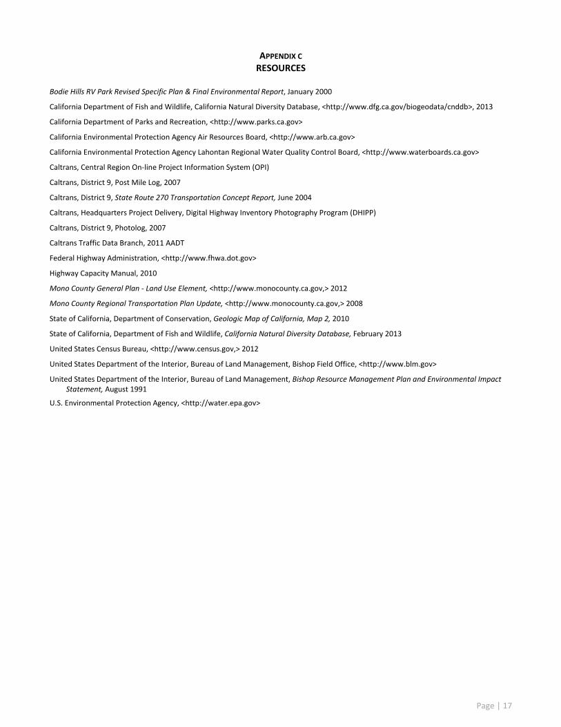
APPENDIX C RESOURCES
Bodie Hills RV Park Revised Specific Plan & Final Environmental Report, January 2000
California Department of Fish and Wildlife, California Natural Diversity Database, <http://www.dfg.ca.gov/biogeodata/cnddb>, 2013
California Department of Parks and Recreation, <http://www.parks.ca.gov>
California Environmental Protection Agency Air Resources Board, <http://www.arb.ca.gov>
California Environmental Protection Agency Lahontan Regional Water Quality Control Board, <http://www.waterboards.ca.gov>
Caltrans, Central Region On-line Project Information System (OPI)
Caltrans, District 9, Post Mile Log, 2007
Caltrans, District 9, State Route 270 Transportation Concept Report, June 2004
Caltrans, Headquarters Project Delivery, Digital Highway Inventory Photography Program (DHIPP)
Caltrans, District 9, Photolog, 2007
Caltrans Traffic Data Branch, 2011 AADT
Federal Highway Administration, <http://www.fhwa.dot.gov>
Highway Capacity Manual, 2010
Mono County General Plan - Land Use Element, <http://www.monocounty.ca.gov,> 2012
Mono County Regional Transportation Plan Update, <http://www.monocounty.ca.gov,> 2008
State of California, Department of Conservation, Geologic Map of California, Map 2, 2010
State of California, Department of Fish and Wildlife, California Natural Diversity Database, February 2013
United States Census Bureau, <http://www.census.gov,> 2012
United States Department of the Interior, Bureau of Land Management, Bishop Field Office, <http://www.blm.gov>
United States Department of the Interior, Bureau of Land Management, Bishop Resource Management Plan and Environmental Impact Statement, August 1991
U.S. Environmental Protection Agency, <http://water.epa.gov>