57
Trash Total Maximum Daily Load for Legg Lake July 11, 2007 California Regional Water Quality Control Board Los Angeles Region 320 West Fourth Street, Suite 200 Los Angeles, California 90013

Trash Total Maximum Daily Load
for
Legg Lake
July 11, 2007
California Regional Water Quality Control Board
Los Angeles Region 320 West Fourth Street, Suite 200
Los Angeles, California 90013

July 11, 2007 2 Legg Lake Trash TMDL
TABLE OF CONTENTS I. INTRODUCTION.........................................................................................................................................6 II. PROBLEM STATEMENT ..........................................................................................................................7
A. Description of the San Gabriel River Watershed and Legg Lake....................................... 7 B. Climate................................................................................................................................ 8 C. Beneficial Uses of Legg Lake........................................................................................... 10 D. Water Quality Objectives.................................................................................................. 11 E. Impairment of Beneficial Uses ......................................................................................... 11 F. Trash Impairments of Legg Lake...................................................................................... 13
III. NUMERIC TARGET .................................................................................................................................14 IV. SOURCE ANALYSIS.................................................................................................................................15
A. Point Sources .................................................................................................................... 15 B. Nonpoint Sources.............................................................................................................. 16
V. LINKAGE ANALYSIS...............................................................................................................................17 VI. WASTE LOAD AND LOAD ALLOCATIONS .......................................................................................17
A. Waste Load Allocations.................................................................................................... 18 B. Load Allocations............................................................................................................... 21
VII. MARGIN OF SAFETY ..............................................................................................................................23 VIII. CRITICAL CONDITIONS ........................................................................................................................23 IX. TMDL IMPLEMENTATION AND COMPLIANCE .............................................................................23
A. Implementation and Compliance for Point Sources ......................................................... 25 B. Implementation and Compliance for Nonpoint Sources................................................... 28 C. Coordinated Compliance .................................................................................................. 31 D. Non-Structural BMPs........................................................................................................ 31 A wide variety of methods possibly alleviating trash impairment to Legg Lake are listed below. Responsible jurisdictions shall propose the monitoring plan as well as the mitigation measures incorporating an individual method or combinations to progressively reduce nonpoint source trash. Non-structural BMPs may provide advantages over structural full capture systems in areas that are not extensively drained by municipal separate storm water sewer systems. Foremost, institutional controls offer other societal benefits associated with reducing litter in our city streets, parks and other public areas. The capital investment required to implement non-structural BMPs is generally less than for full capture systems.................. 31 E. Implementation Schedule.................................................................................................. 35 F. Reasonably Foreseeable Environmental Impacts from TMDL Implementation.............. 38
X. MONITORING ...........................................................................................................................................39 XI. FUTURE GROWTH ..................................................................................................................................42 XII. COST CONSIDERATIONS ......................................................................................................................42 XIII. BIBLIOGRAPHY .........................................................................................................................................48 XIV. APPENDIX I ................................................................................................................................................51 XV. APPENDIX II ...............................................................................................................................................52

July 11, 2007 3 Legg Lake Trash TMDL
XVI. APPENDIX III ..............................................................................................................................................53 XVII. DEFINITIONS..............................................................................................................................................54

July 11, 2007 4 Legg Lake Trash TMDL
LIST OF TABLES TABLE 1. BENEFICIAL USES OF LEGG LAKE................................................................................... 11 TABLE 2. STORM DEBRIS COLLECTION SUMMARY FOR LONG BEACH: DEBRIS MEASURED IN
TONNAGE (SIGNAL HILL 2006) ............................................................................................... 16 TABLE 3. AVERAGE COMBINED TOTAL LOADS FOR CONTROL OUTFALLS AT 3 LITTER
MANAGEMENT PILOT STUDY SITES ........................................................................................ 20 TABLE 4. BASELINE WASTE LOAD ALLOCATION FOR WEIGHT AND VOLUME FOR FREEWAYS...... 20 TABLE 5. LEGG LAKE BASELINE WASTE LOAD ALLOCATIONS (GALLONS OF UNCOMPRESSED
LITTER).................................................................................................................................... 20 TABLE 6. LAKE LEGG LAKE TRASH TMDL BASELINE LOAD ALLOCATIONS (GALLONS OF
UNCOMPRESSED LITTER) ......................................................................................................... 23 TABLE 7. POINT SOURCE RESPONSIBLE JURISDICTIONS – LEGG LAKE .......................................... 26 TABLE 8. NONPOINT SOURCE RESPONSIBLE JURISDICTIONS – LEGG LAKE ................................... 29 TABLE 9. FULL CAPTURE IMPLEMENTATION SCHEDULE................................................................ 35 TABLE 10. MINIMUM FREQUENCY ASSESSMENT AND COLLECTION IMPLEMENTATION SCHEDULE 37 TABLE 11. TRASH MONITORING AND REPORTING PLAN DUE DATES ............................................ 40 TABLE 12. COSTS OF RETROFITTING THE CATCH BASIN INSERTS (DOLLARS IN THOUSANDS) ......... 43 TABLE 13. COSTS ASSOCIATED WITH VSS .................................................................................... 44 TABLE 14. COSTS ASSOCIATED WITH LOW CAPACITY VORTEX GROSS POLLUTANT SEPARATION
SYSTEMS (DOLLARS IN THOUSANDS) ...................................................................................... 44 TABLE 15. COSTS ASSOCIATED WITH LARGE CAPACITY VORTEX GROSS POLLUTANT SEPARATION
SYSTEMS (DOLLARS IN THOUSANDS) ...................................................................................... 45 TABLE 16. SAMPLE COSTS FOR END OF PIPE NETS ........................................................................ 46 TABLE 17. COST COMPARISON (AMOUNTS IN MILLIONS) ............................................................... 47
July 11, 2007 5 Legg Lake Trash TMDL
LIST OF FIGURES FIGURE 1. LEGG LAKE IN THE SAN GABRIEL RIVER WATERSHED ................................................... 8 FIGURE 2. ISOHYETAL MAP OF RAINFALL INTENSITIES IN PORTIONS OF LOS ANGELES COUNTY .... 9 FIGURE 3. BLUE HERON AND COOTS AT LEGG LAKE ...................................................................... 10 FIGURE 4. LEGG LAKE IMPAIRED BY TRASH................................................................................... 14 FIGURE 5. AREAS USED TO DETERMINE BASELINE WASTE LOAD AND LOAD ALLOCATIONS FOR
POINT AND NONPOINT SOURCES TRASH AT LEGG LAKE ........................................................... 22 FIGURE 6. IMPLEMENTATION FLOWCHART FOR POINT SOURCES ................................................... 28 FIGURE 7. IMPLEMENTATION FLOWCHART FOR NONPOINT SOURCES ............................................ 31

July 11, 2007 6 Legg Lake Trash TMDL
I. Introduction
The California Regional Water Quality Control Board, Los Angeles Region (Regional Board) has developed this total maximum daily load (TMDL) to attain the water quality standards for trash Legg Lake in the San Gabriel River Watershed. The TMDL has been prepared pursuant to state and federal requirements to preserve and enhance water quality for impaired waterbodies within Coastal Watersheds of Los Angeles and Ventura Counties. The California Water Quality Control Plan, Los Angeles Region (Basin Plan) sets standards for surface waters and ground waters in the Coastal Watersheds of Los Angeles and Ventura Counties. These standards are comprised of designated beneficial uses for surface and ground water, numeric and narrative objectives necessary to support beneficial uses, and the state’s antidegradation policy. Such standards are mandated for all waterbodies within the state under the Porter-Cologne Water Quality Act. In addition, the Basin Plan describes implementation programs to protect all waters in the region. The Basin Plan implements the Porter-Cologne Water Quality Act (also known as the “California Water Code”) and serves as the State Water Quality Control Plan applicable to the lakes mentioned above, as required pursuant to the federal Clean Water Act (CWA). Section 305(b) of the CWA mandates biennial assessment of the nation’s water resources, and these water quality assessments are used to identify and list impaired waters. The resulting list is referred to as the 303(d) list. The CWA also requires states to establish a priority ranking for impaired waters and to develop and implement TMDLs. A TMDL specifies the maximum amount of a pollutant that a waterbody can receive and still meet water quality standards, and allocates pollutant loadings to point and non-point sources. The United States Environmental Protection Agency (USEPA) has oversight authority for the 303(d) program and must approve or disapprove the state’s 303(d) lists and each specific TMDL. USEPA is ultimately responsible for issuing a TMDL, if the state fails to do so in a timely manner. As part of California’s 1996, 1998, and 2002 303(d) list submittals, the Regional Board identified Legg Lake as being impaired due to trash. A consent decree between the USEPA, the Santa Monica BayKeeper and Heal the Bay Inc., represented by the Natural Resources Defense Council (NRDC), was signed on March 22, 1999. This consent decree requires that all TMDLs for the Los Angeles Region be adopted within 13 years. The consent decree also prescribed schedules for certain TMDLs. This TMDL for Legg Lake fulfills Analytical Unit No. 40 of the Consent Decree.
This TMDL staff report and accompanying Basin Plan Amendment incorporate the numeric targets, Baseline Waste Load Allocations for point sources and Baseline Load

July 11, 2007 7 Legg Lake Trash TMDL
Allocations for nonpoint sources, margin of safety and implementation and compliance schedules.
The Trash TMDL for Legg Lake will be implemented by a Basin Plan Amendment and are therefore subject to Public Resources Code Section 21083.9 that requires California Environmental Quality Act (CEQA) Scoping and Analysis to be conducted for Regional Projects. CEQA Scoping involves identifying a range of project/program related actions, alternatives, mitigation measures, and significant effects to be analyzed in an EIR or its Substitute Environmental Documents (SEDs). On December 6, 2006 a CEQA Scoping meeting was held at the Regional Board office to present and discuss the foreseeable potential environmental impacts of compliance with the Legg Lake Trash TMDL. Notices of the CEQA Scoping hearing were posted in the Los Angeles Times Newspaper on November 3, 2006 and on Regional Board’s website. Electronic mails were also sent to interested parties including cities and/or counties with jurisdiction in or bordering the watersheds of concerns. Input from all stakeholders and interested parties was solicited for consideration in the development of the CEQA document. This Trash TMDL is based on existing, readily available information concerning the conditions in the CWA 303(d) listed watershed in Southern California, as well as TMDLs previously developed by the State and USEPA.
II. Problem Statement
The problem statement consists of descriptions of the watershed, climate, beneficial uses, water quality objectives, and impairments caused by trash to Legg Lake.
A. Description of the San Gabriel River Watershed and Legg Lake
The San Gabriel River receives drainage from a large area of eastern Los Angeles
County; its headwaters originate in the San Gabriel Mountains. The watershed consists of extensive areas of undisturbed riparian and woodland habitats in its upper reaches. Much of the watershed of the West Fork and East Fork of the river is set aside as a wilderness area; other areas in the upper watershed are subject to heavy recreational use. The upper watershed also contains a series of flood control dams. Further downstream, towards the middle of the watershed, are large spreading grounds used for groundwater recharge. The watershed is hydraulically connected to the Los Angeles River through the Whittier Narrows Flood Control Basin in the following manner: The Rio Hondo branches from the San Gabriel River just below Santa Fe Dam and flows westward to Whittier Narrows Flood Control Basin. Flows from the San Gabriel River and Rio Hondo can merge at this reservoir during larger flood events. From Whittier Narrows, the Rio Hondo flows southwestward and merges with the Los Angeles River, while the San Gabriel River becomes a concrete-lined channel and discharges to the Pacific Ocean near the City of Long Beach.

July 11, 2007 8 Legg Lake Trash TMDL
Legg Lake, built in 1963, is located in the Whittier Narrows Flood Control Basin. Whittier Narrows Dam is to the south of the Lake. The Rio Hondo and the San Gabriel River flow by the lake’s east and west boundaries, respectively (Figure 1). Legg Lake has an average depth of 3 feet along the edge of the Lake and up to 10 feet near the center of the Lake. Whittier Narrows is managed by the Los Angeles County Department of Parks and Recreation for park and recreational purposes.
The primary sources of water in Legg Lake are runoff from the San Gabriel River and
nearby wells because the flood control basin also serves as a conservation pool for groundwater recharge. In addition, two storm drains collecting runoff from the cities of El Monte and South El Monte discharge to Legg Lake at its northeast end.
Figure 1. Legg Lake in the San Gabriel River Watershed
B. Climate The climate in the San Gabriel River watershed is typical of southern California. Summers are relatively warm and dry and winters are mildly wet. Storm events and the resulting high stream flows are highly seasonal, grouped heavily in the months of October through March, with an

July 11, 2007 9 Legg Lake Trash TMDL
occasional major storm as early as September and as late as April. Rainfall is rare in other months, and major storm flows historically have not been observed outside of the wet-weather season. An Isohyetal Map of Rainfall Intensities in Portions of Los Angeles County is presented in Figure 2.
Figure 2. Isohyetal Map of Rainfall Intensities in Portions of Los Angeles County
Prepared by Los Angeles County Department of Public Works, 2003. Map may be updated by the Los Angeles County hydrologist to reflect additional rain data. Data published by the Los Angeles County Department of Public Works are prospectively incorporated by reference into this TMDL and accompanying Basin Plan amendment.
July 11, 2007 10 Legg Lake Trash TMDL
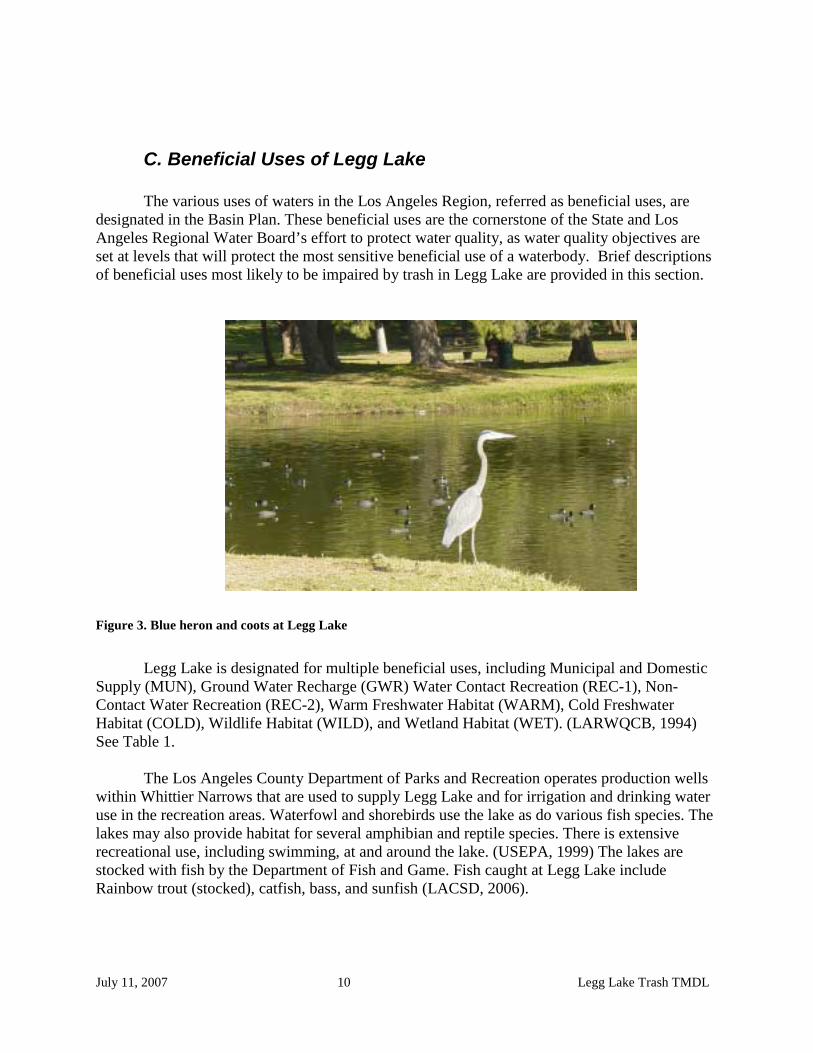
C. Beneficial Uses of Legg Lake
The various uses of waters in the Los Angeles Region, referred as beneficial uses, are designated in the Basin Plan. These beneficial uses are the cornerstone of the State and Los Angeles Regional Water Board’s effort to protect water quality, as water quality objectives are set at levels that will protect the most sensitive beneficial use of a waterbody. Brief descriptions of beneficial uses most likely to be impaired by trash in Legg Lake are provided in this section.
Figure 3. Blue heron and coots at Legg Lake
Legg Lake is designated for multiple beneficial uses, including Municipal and Domestic
Supply (MUN), Ground Water Recharge (GWR) Water Contact Recreation (REC-1), Non-Contact Water Recreation (REC-2), Warm Freshwater Habitat (WARM), Cold Freshwater Habitat (COLD), Wildlife Habitat (WILD), and Wetland Habitat (WET). (LARWQCB, 1994) See Table 1.
The Los Angeles County Department of Parks and Recreation operates production wells
within Whittier Narrows that are used to supply Legg Lake and for irrigation and drinking water use in the recreation areas. Waterfowl and shorebirds use the lake as do various fish species. The lakes may also provide habitat for several amphibian and reptile species. There is extensive recreational use, including swimming, at and around the lake. (USEPA, 1999) The lakes are stocked with fish by the Department of Fish and Game. Fish caught at Legg Lake include Rainbow trout (stocked), catfish, bass, and sunfish (LACSD, 2006).

July 11, 2007 11 Legg Lake Trash TMDL
Table 1. Beneficial Uses of Legg Lake
Surface Waters Hydro Unit
MU N
GWR
R E C 1
R E C 2
WA R M
C O L D
W I L D
WE T
Legg Lake 405.41 P* E E E E E E E E Existing beneficial use P Potential beneficial use * MUN designation under SB 88-63 and RB 89-03. Some may be exempt.
D. Water Quality Objectives
Water quality standards consist of a combination of beneficial uses, water quality objectives and the State’s Antidegradation Policy. Regional Board staff finds that the narrative water quality objectives applicable to this TMDL are floating materials: “Waters shall not contain floating materials, including solids, liquids, foams, and scum, in concentrations that cause nuisance or adversely affect beneficial uses” and solid, suspended, or settleable materials: “Waters shall not contain suspended or settleable material in concentrations that cause nuisance or adversely affect beneficial uses.” The State’s Antidegradation Policy is formally referred to as the Statement of Policy with Respect to Maintaining High Quality Waters in California (State Board Resolution No. 68-16).
E. Impairment of Beneficial Uses
Existing beneficial uses impaired by trash in the Legg Lake are REC-1 and REC-2 uses such as fishing (trash is aesthetically displeasing and deters recreational use and tourism) and WARM and COLD (impaired by accumulations of suspended and settled debris). Common items that have been observed by Regional Board staff include styrofoam cups, styrofoam food containers, glass and plastic bottles, paper cartons, packaging materials, plastic bags, and cans. Heavier debris can be transported during storms as well. Trash in waterways causes significant water quality problems. Small and large floatables can inhibit the growth of aquatic vegetation, decreasing spawning areas and habitats for fish and other living organisms. Wildlife living in lakes and in riparian areas can be harmed by ingesting or becoming entangled in floating trash. Except for large items, settleables are not always obvious to the eye. They include glass, cigarette butts, rubber, construction debris and more. Settleables can be a problem for bottom feeders and can contribute to sediment contamination. Some debris (e.g. diapers, medical and household waste, and chemicals) are a source of bacteria and toxic substances.

July 11, 2007 12 Legg Lake Trash TMDL
For aquatic life, buoyant (floatable) elements tend to be more harmful than settleable elements, due to their ability to be transported throughout the water body. Persistent elements such as plastics, synthetic rubber and synthetic cloth tend to be more harmful than degradable elements such as paper or organic waste. Glass and metal are less persistent, even though they are not biodegradable, because wave action and rusting can cause them to break into smaller pieces that are less sharp and harmful. Natural rubber and cloth can degrade but not as quickly as paper (U.S. EPA, 2002). Smaller elements such as plastic resin pellets (a by-product of plastic manufacturing) and cigarette butts are often more harmful to aquatic life than larger elements, since they can be ingested by a large number of small organisms which can then suffer malnutrition or internal injuries. Larger plastic elements such as plastic grocery bags are also harmful to larger aquatic life, which can mistake the trash for floating prey and ingest it, leading to starvation or suffocation.
Trash in water bodies can threaten the health of people who use them for wading or swimming. Of particular concern are the bacteria and viruses associated with diapers, medical waste (e.g., used hypodermic needles and pipettes), and human or pet waste. Additionally, broken glass or sharp metal fragments in streams can cause puncture or laceration injuries. Such injuries can then expose a person’s bloodstream to microbes in the stream’s water that may cause illness. Also, some trash items such as containers or tires can pond water and support mosquito production and associated risks of diseases such as encephalitis and the West Nile virus.
Leaf litter is considered trash when there is evidence of intentional dumping. Leaves and pine needles in lakes and streams provide a natural source of food for organisms, but excessive levels due to human influence can cause nutrient imbalance and oxygen depletion in streams, to the detriment of the aquatic ecosystem. Clumps of leaf litter and yard waste from trash bags should be treated as trash in the water quality assessment, and not confused with natural inputs of leaves to streams. If there is a question in the field, check the type of leaf to confirm that it comes from a nearby riparian tree. In some instances, leaf litter may be trash if it originates from dense ornamental stands of nearby human planted trees that are overloading the stream’s assimilative capacity for leaf inputs. Other biodegradable trash, such as food waste, also exerts a demand on dissolved oxygen, but aquatic life is unlikely to be adversely affected unless the dumping of food waste is substantial and persistent at a given location.
The two primary problems that trash poses to wildlife are entanglement and ingestion, with entanglement the more common documented effect (Laist and Liffmann, 2000). Entanglement results when an animal becomes encircled or ensnared by debris. It can occur accidentally, or when the animal is attracted to the debris as part of its normal behavior or out of curiosity. Entanglement is harmful to wildlife for several reasons. Not only can it cause wounds that can lead to infections or loss of limbs; it can also cause strangulation or suffocation. In addition, entanglement can impair an animal's ability to swim, which can result in drowning, or in difficulty in moving, finding food, or escaping predators (U.S. EPA, 2001). Ingestion occurs when an animal swallows floatable debris. It sometimes occurs accidentally, but usually animals feed on debris because it looks like food. Ingestion can lead to starvation or malnutrition if the ingested items block the intestinal tract and prevent digestion, or accumulate in the digestive tract, making the animal feel "full" and lessening its desire to feed. Ingestion of sharp objects can
July 11, 2007 13 Legg Lake Trash TMDL
damage the mouth, digestive tract and/or stomach lining and cause infection or pain. Ingested items can also block air passages and prevent breathing, thereby causing death (U.S. EPA, 2001).
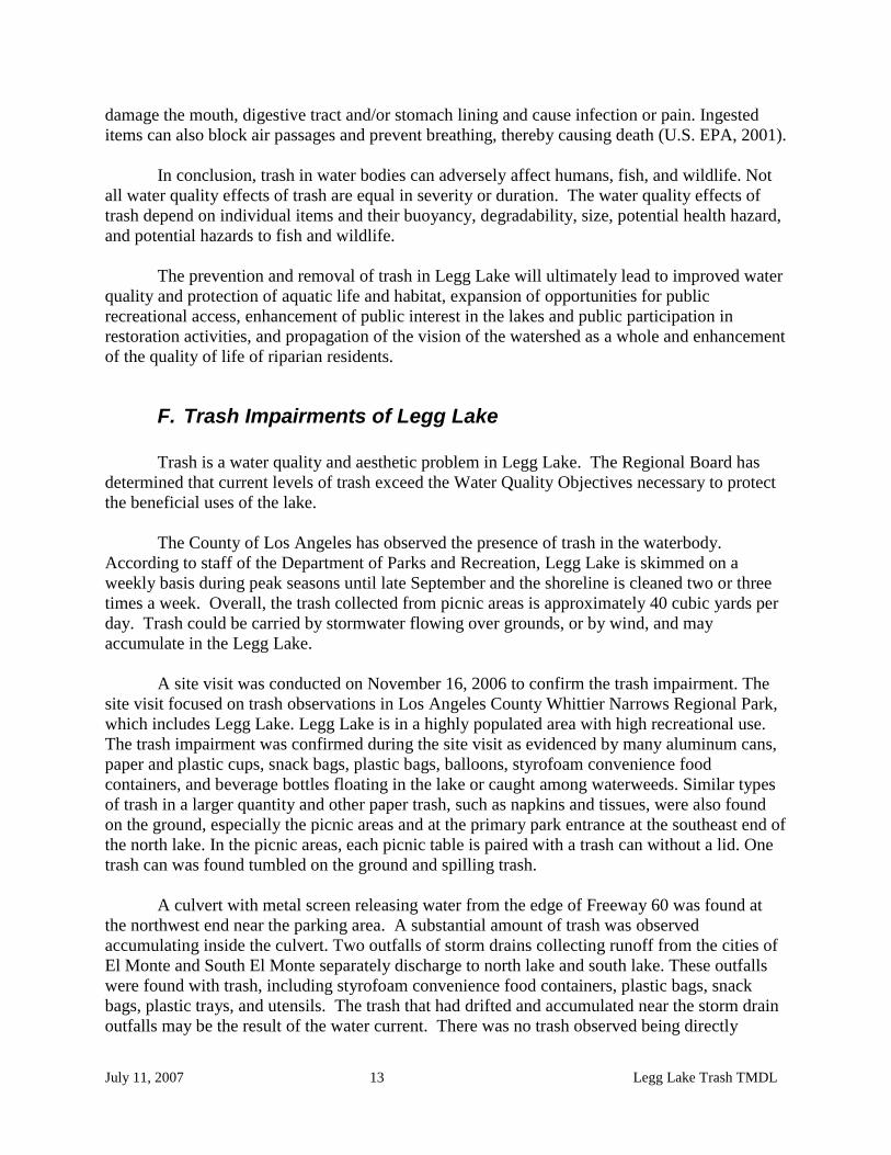
In conclusion, trash in water bodies can adversely affect humans, fish, and wildlife. Not all water quality effects of trash are equal in severity or duration. The water quality effects of trash depend on individual items and their buoyancy, degradability, size, potential health hazard, and potential hazards to fish and wildlife.
The prevention and removal of trash in Legg Lake will ultimately lead to improved water quality and protection of aquatic life and habitat, expansion of opportunities for public recreational access, enhancement of public interest in the lakes and public participation in restoration activities, and propagation of the vision of the watershed as a whole and enhancement of the quality of life of riparian residents.
F. Trash Impairments of Legg Lake
Trash is a water quality and aesthetic problem in Legg Lake. The Regional Board has determined that current levels of trash exceed the Water Quality Objectives necessary to protect the beneficial uses of the lake.
The County of Los Angeles has observed the presence of trash in the waterbody.
According to staff of the Department of Parks and Recreation, Legg Lake is skimmed on a weekly basis during peak seasons until late September and the shoreline is cleaned two or three times a week. Overall, the trash collected from picnic areas is approximately 40 cubic yards per day. Trash could be carried by stormwater flowing over grounds, or by wind, and may accumulate in the Legg Lake.
A site visit was conducted on November 16, 2006 to confirm the trash impairment. The
site visit focused on trash observations in Los Angeles County Whittier Narrows Regional Park, which includes Legg Lake. Legg Lake is in a highly populated area with high recreational use. The trash impairment was confirmed during the site visit as evidenced by many aluminum cans, paper and plastic cups, snack bags, plastic bags, balloons, styrofoam convenience food containers, and beverage bottles floating in the lake or caught among waterweeds. Similar types of trash in a larger quantity and other paper trash, such as napkins and tissues, were also found on the ground, especially the picnic areas and at the primary park entrance at the southeast end of the north lake. In the picnic areas, each picnic table is paired with a trash can without a lid. One trash can was found tumbled on the ground and spilling trash.
A culvert with metal screen releasing water from the edge of Freeway 60 was found at
the northwest end near the parking area. A substantial amount of trash was observed accumulating inside the culvert. Two outfalls of storm drains collecting runoff from the cities of El Monte and South El Monte separately discharge to north lake and south lake. These outfalls were found with trash, including styrofoam convenience food containers, plastic bags, snack bags, plastic trays, and utensils. The trash that had drifted and accumulated near the storm drain outfalls may be the result of the water current. There was no trash observed being directly

July 11, 2007 14 Legg Lake Trash TMDL
discharged from the outfalls to the lake. According to the weather records, it had not rained within two weeks prior to the inspection.
The characteristics of trash in this park indicate that most trash is contributed by park
users. The photo below (Figure 4) was taken near the storm drain outfall at South Lake.
Figure 4. Legg Lake impaired by trash
III. Numeric Target
The numeric target is derived from the narrative water quality objective in the Basin Plan for floating material:
“Waters shall not contain floating materials, including solids, liquids, foams, and scum, in concentrations that cause nuisance or adversely affect beneficial uses”;
and for solid, suspended, or settleable materials:
“Waters shall not contain suspended or settleable material in concentrations that cause nuisance or adversely affect beneficial uses.”
The numeric target for this TMDL is 0 (zero) trash in or on Legg Lake and on the
shoreline. Zero is defined as no trash immediately following each collection and assessment consistent with an established Minimum Frequency. The Minimum Frequency is established at an interval that prevents trash from accumulating in deleterious amounts in between collections. Regional Board staff has not found information to justify any value other than zero that would fully support the designated beneficial uses. Further, court rulings have found that a numeric target of zero trash is legally valid. The numeric target was used to calculate the Load

July 11, 2007 15 Legg Lake Trash TMDL
Allocations for nonpoint sources and Waste Load Allocations for point sources, as described in the following sections of this Staff Report.
IV. Source Analysis
The major source of trash in the lake results from litter, which is intentionally or accidentally discarded in watershed drainage areas and in the vicinity of Legg Lake. These potential sources can be categorized as point sources and nonpoint sources depending on the transport mechanisms which include:
1. Storm drains: trash that is deposited throughout the watershed is carried to the various sections of the lake during and after rainstorms through storm drains. This is a point source.
2. Wind action: trash can also blow into the lake directly. This is a nonpoint source.
3. Direct disposal: direct dumping or litter into the lake. This is a nonpoint source. Based on the land uses in the vicinity of the lake, the observed trash characteristics at the lake during the site visit, and the fact that only two storm drains discharge to the Lake, it is determined that nonpoint sources are the dominant source of trash to Legg Lake.
A. Point Sources
Trash conveyed by storm water through storm drains to Legg Lake is evidenced by trash accumulation at the base of storm drains discharging to the lake and catch basins which collect runoff from surrounding lands.
Based on reports and research on other watersheds, the amount and type of trash washed
into the storm drain system appears to be a function of the surrounding land use. The City of Long Beach has recorded trash quantity collected at the mouth of the Los Angeles River; the result suggested that the total trash amount is somewhat linearly correlated with the precipitation (see Table 2). A similar conclusion was also found that the amount of gross pollutants entering the storm water system is rainfall dependent but does not necessarily depend on the source (Walker and Wong, December 1999). The amount of trash which enters the storm water system depends on the energy available to re-mobilize and transport deposited gross pollutants on street surfaces rather than on the amount of available gross pollutants deposited on street surfaces. Where gross pollutants exist, a clear relationship between the gross pollutant load in the storm water system and the magnitude of the storm event has been established. The limiting mechanism affecting the transport of gross pollutants, in the majority of cases, appears to be re-mobilization and transport processes (i.e., storm water rates and velocities).

July 11, 2007 16 Legg Lake Trash TMDL
Table 2. Storm Debris Collection Summary for Long Beach: Debris measured in Tonnage (Signal Hill 2006)
Year Trash (Tons) Precipitation (inches) 95-96 4162 12.44 96-97 3993 12.4 97-98 9290 31.01 98-99 3091 9.09 99-00 3844 11.57 00-01 4437 17.94 01-02 1858 4.42 02-03 4630 16.42 03-04 2636 9.25 04-05 12225 37.25 05-06 1059 13.19
To estimate trash generation rates, research from other watersheds was analyzed by
Regional Board staff. The most comparable watershed study to the point source land uses surrounding Legg Lake was done by Los Angeles County Department of Public Works during the 2002/03 and 2003/04 storm years for Los Angeles River and Ballona Creek Watersheds. Los Angeles County, under the conditional approval by Executive Officer of Los Angeles Regional Board, implemented Los Angeles Litter Monitoring Plan incorporating trash quantity analysis from land uses of high density residential, low density residential, commercial, industrial and open space/park. Trash collected from catch basins or CDS units, excluding sediment and vegetation from man-made trash, was weighed after “drip dry” process.
B. Nonpoint Sources Nonpoint source pollution is commonly caused by a wide range of activities including urban development, agriculture, and recreation, and is identified as a parallel attribute to the trash problem at Legg Lake. This waterbody supports recreational activities such as picnicking, boating, and fishing. The trash deposited in the lake resulting from nonpoint sources is a function of transport mechanisms including wind and storm water. There are limited studies particularly to define the relationship between the strength of winds and movement of trash from land surface to a waterbody. Lighter trash with sufficient surface area to sail with wind, such as plastic bags, beverage containers, paper or plastic convenient food containers are easily lifted, and carried to waterbodies. Also, as described in the point source section, storm water carries trash from lakeshores to waterbodies. Transportation of pollutants from one location to another is determined by the energy of both wind and storm water. In consideration of transport mechanisms, existing trash in the environment nearby the lake is the fundamental cause of nonpoint sources trash loading. The lake is completely surrounded by a park. Different uses of the park may be responsible for different degrees of trash impairment. For example, areas with picnic tables closer to the lake have a higher likelihood to

July 11, 2007 17 Legg Lake Trash TMDL
generate trash in the lake than parking lots. Visitation rates also appear to be correlated to the amount of trash from nonpoint sources. In the surrounding residential areas, residents may accidentally discard trash to neighborhoods and roads, which can then be transported to the lake via wind or storm water. Most of the nonpoint source trash along the lakeshore eligible to travel with wind or storm water to the lake is the result of human activities. Records of cleanup days at Lake Erie in 2006 indicate that the top items found were cigarette butts, beverage containers, food wrappers/containers, caps and lids, and eating utensils (Pennsylvania, 2006). These findings are consistent with the items found around Legg Lake during site inspections.
V. Linkage Analysis
This TMDL is based on numeric targets derived from narrative water quality objectives for floating materials and solid, suspended, or settleable materials. The narrative objectives prescribe that waters shall not contain these materials in concentrations that cause nuisance or adversely affect beneficial uses. Based on these targets, staff finds the capacity of Legg Lake to accumulate trash is zero.
VI. Waste Load and Load Allocations
Both point sources and nonpoint sources are identified as sources of trash in Legg Lake. For point sources, the strategy for attaining water quality standards focuses on assigning a Waste Load Allocation (WLA) to the California Department of Transportation (Caltrans) and the Permittees and Co-Permittees of the Los Angeles County Municipal Separate Storm Sewer System (MS4) Permit (hereinafter referred to as Permittees). The WLA will be implemented through permit requirements. For nonpoint sources, the strategy for attaining water quality standards focuses on assigning a Load Allocation (LA) to the Los Angeles County Department of Parks and Recreation. The LA will be implemented through regulatory mechanisms that implement the State Board’s 2004 Nonpoint Source Policy such as waste discharge requirements or waivers. The final WLA and LA are zero trash.
WLAs and LAs are based on a phased reduction from Baseline WLAs and LAs,
estimated as the current discharge, over an eight-year period for the full capture compliance option and a five-year period for the MFAC compliance option, as discussed below. Permittees may comply with the WLA through implementing full capture systems on storm drains through a progressive implementation schedule or implementing a program for Minimum Frequency of Assessment and Collection (MFAC) in conjunction with a progressive trash reduction schedule. LA assignees may comply with LAs through implementation of a conditional waiver that implements a MFAC program or an alternative program subject to individual waste discharge requirements or an individual waiver thereof.
The Baseline WLA for the MS4 Permittees is based on a study conducted as part of the
Los Angeles River Trash TMDL. The Baseline WLA for Caltrans is based on their Litter

July 11, 2007 18 Legg Lake Trash TMDL
Management Pilot Study. The Baseline LA for nonpoint sources is based on data from recent trash generation studies from the City of Calabasas. The Regional Board may revise the Baseline WLAs and LAs based on studies provided by Responsible Jurisdictions within the first two years of the TMDL implementation period.
A. Waste Load Allocations
Waste Load Allocations for point sources are assigned to the Permittees of MS4 and Caltrans. WLAs may be issued to additional facilities in the future under Phase II of the US EPA Stormwater Permitting Program. The Baseline Waste Load and Load Allocations for Permittees may be revised with data collected during the Trash Monitoring and Reporting Plan (TMRP) in the first two years of the implementation period.
Baseline Waste Load Allocations for MS4 Permittees
Municipal stormwater permittees may implement their TMRPs to obtain site specific trash generation rates for the first two years of the implementation period, and, if approved by the Regional Board’s Executive Officer, ultimately define the trash Baseline Waste Load Allocations. The TMRP will derive a representative trash generation rate for various land uses from responsible permittees discharging stormwater to the waterbodies. This TMRP shall include, but is not limited to, assessment and quantification of trash collected from the surfaces and shoreline of Legg Lake or from responsible jurisdiction land areas. The monitoring plan shall provide details of the frequency, location, and reporting of trash monitoring. Responsible jurisdictions shall propose a metric (e.g., weight, volume, pieces of trash) to measure the amount of trash in Legg Lake and on the land area surrounding the lake. The derived trash generation rate may be used to define an appropriate Waste Load Allocation, which will be implemented upon approval by the Executive Officer.
Los Angeles County, under the conditional approval by Executive Officer of Los Angeles
Regional Board, implemented the Los Angeles Litter Monitoring Plan incorporating trash quantity analysis from land uses of high density residential, low density residential, commercial, industrial and open space/park. The Los Angeles Litter Monitoring Plan Study (LMPS) was implemented by the Los Angeles Department of Public Works during the 2002/03 and 2003/04 storm years for the Los Angeles River and Ballona Creek Watersheds. Trash collected from catch basins or CDS units, excluding sediment and vegetation from man-made trash, was weighed after a “drip dry” process. The Baseline Waste Load Allocation is calculated by averaging the total trash amount measured in a 2-year period divided by all drainage areas for all land uses. However, no differentiation is applied for different land uses in the MS4 Baseline Waste Load Allocation.
Based on the LMPS, MS4 Permittees may use the trash generation rate of 5334 gallons of
uncompressed trash per square mile per year. Responsible jurisdictions may also choose to propose site specific data based on the trash generation rate derived from two years of data collected from the TMRP.

July 11, 2007 19 Legg Lake Trash TMDL
MS4 Permittees shall implement a Trash Monitoring and Reporting Plan, and may use the data collected in two years after the effective date of this Trash TMDL to refine the Baseline Waste Load Allocation. One of the goals of the Trash Monitoring and Reporting Plan is to derive a representative trash generation rate for various land uses from responsible jurisdictions discharging stormwater to Legg Lake. The Baseline Waste Load Allocation for any single permittee is the sum of the products of each land use area multiplied by the Waste Load Allocation for the land use area, as shown below:
( )∑ •= uselandthisforsallocationuseslandbyareacityeachforWLA
Southern California Association of Governments (SCAG) classified twelve types of land
uses for every city and unincorporated area in the watershed. The land use categories are: (1) high density residential , (2) low density residential , (3) commercial and services, (4) industrial, (5) public facilities, (6) educational institutions , (7) military installations, (8) transportation , (9) mixed urban , (10) open space and recreation , (11) agriculture , and (12) water . Given that the minimum mapping resolution is 2.5 acres, a non-critical land use unit may not be mapped if it is less than 2.5 acres in size. The details of land use categories are provided in the Appendix I.
Data collected during Trash Monitoring and Reporting Plan may be used to establish
specific trash generation rates per land use. Land uses for Public facilities, Educational Institutions, Mixed urban, Agriculture, and Water were exempt from monitoring based on the assumption made by Los Angeles County that the public facilities and mixed urban land uses have the same litter generation rate. It also applies to transportation and industrial land uses, and agricultural and open space land uses. Transportation land use under Caltrans’ jurisdiction will be covered under Caltrans’ permit. Caltrans will be required to submit a monitoring plan for that land use, and will be assigned a Waste Load Allocation. Major boulevards that are currently under Caltrans’ jurisdiction, but are affected by trash generated on municipal sites will be addressed by the cities concerned.
Permittees may provide acreage of above mentioned land uses within their jurisdiction in order to revise their contributions from their assigned Baseline Waste Load Allocations. The Baseline Waste Load Allocations for all point sources are presented in Table 5. The values shown are uncompressed volumes in gallons. A more detailed breakdown along land uses is provided in Appendix II and III. The appendices contain tables which show the square mileage for each land use for each responsible jurisdiction in watershed, and a list of maps showing land uses for each permittee. For permittees that are only partially located in the watershed, the square mileage indicated is for the portion in the watershed only.
Baseline Waste Load Allocations for Caltrans
Under the Los Angeles River TMDL, a Litter Management Pilot Study (LMPS) was conducted to evaluate the effectiveness of several litter management practices in reducing litter that is discharged from Caltrans storm water conveyance systems. The LMPS employed four field study sites, each of which was used to test a separate BMP. Each site included three replicate testing pairs, consisting of one site designed to measure the amount of trash produced when treatment was applied, and one control with no treatment site. The LMPS averaged the

July 11, 2007 20 Legg Lake Trash TMDL
data collected at the control outfalls in order to obtain the annual litter loads. The average combined total loads for the three control outfalls at each site normalized by the total area of control catchments is presented in Table 3, adapted from the LMPS report: Table 3. Average Combined Total Loads for Control Outfalls at 3 Litter Management Pilot Study Sites
Site Weight lbs/sq mi Volume cu ft/sq mi 1E 10584.00 1312.97 1W 7479.36 971.73 6 7479.36 881.34 8 4374.72 404.51
The Baseline Waste Load Allocation for weight and volume load generation for freeways
is arrived at by averaging weight and volume columns (Table 4). It is to be noted that control site 1E already had one BMP in place before testing of the other BMPs, as it was cleaned monthly through an “Adopt a Highway” program. Table 4. Baseline Waste Load Allocation for Weight and Volume for Freeways
Weight lbs/sq mi Volume cu ft/sq mi7479.36 892.64
Baseline Waste Load Allocations for MS4 and Caltrans Permittees Table 5 shows the Baseline WLAs for all point sources, in gallons per year, assuming a
trash generation rate of 5334 gallons of uncompressed trash per square mile per year. If the MS4 Permittees use their TMRPs to derive site specific trash generation rates, the Baseline WLAs will be calculated by multiplying the point source areas by the derived trash generation rates. The point source area for Los Angeles County is determined by the surface area of Whittier Narrows Regional Park that drains to existing conveyances, while the surface area for Los Angeles County Flood Control District is an estimate of the County-maintained storm drain system. The Baseline WLA for Caltrans was based on a trash generation rate of 6677 gallons of uncompressed trash per square mile per year as determined by LMPS studies. Table 5. Legg Lake Baseline Waste Load Allocations, assuming the existing trash generation rates
Responsible Jurisdictions Point Source Area (Mile2) Baseline WLA (gals/year) Los Angeles County 0.45 2400.03
Los Angeles County Flood Control District 0.005 24.05 City of El Monte 0.10 509.48
City of South El Monte 0.73 3896.76 Caltrans 0.09 586.92

July 11, 2007 21 Legg Lake Trash TMDL
B. Load Allocations
Load Allocations for nonpoint sources also follow phased reduction from Baseline Load Allocations. According to the Porter Cologne Act, Load Allocations may be addressed by conditional waivers of WDRs.
Responsible jurisdictions shall monitor the trash quantity deposited on the lake and the shoreline and in the vicinities of the lake. Data collected through Trash Monitoring and Reporting Plan may define the percentage of trash migrating from land to the lake. The area adjacent to the lake, or defined as the nonpoint source area, is the composition of multiple land uses. There are parking lots, recreational areas, and picnic areas under the jurisdiction of the Los Angeles County Department of Parks and Recreation. Each sub-area described above may contribute at different levels of trash to the lake. By applying the similar concept that was applied for the Waste Load Allocation, the Load Allocation for any designated nonpoint source area is the sum of the products of each land use sub area multiplied by the Load Allocation for the land use sub area, as shown below:
( )∑ •= uselandthisforsallocationuseslandbysubareasourceNonpeachforLA oint
The boundary of point source areas for Legg Lake is defined by the extent of storm drains discharging to the Lake, which includes parts of the Cities of El Monte and South El Monte at the north and west ends of Legg Lake. Nonpoint source areas are defined as areas where trash may be carried over ground by stormwater, wind or park users to the Lake. Generally, the entire Whittier Narrows Regional Park is considered as the nonpoint source area. Figure 5 illustrates the subwatershed areas used to calculate Baseline Waste Load and Load Allocation by each land use’s surface.
Due to the transportation mechanism by wind and stormwater to relocate trash from land to
waterbodies, the potential nonpoint source area may be smaller than the defined subwatershed. For the magnitude of surface area around Legg Lake, it may not be necessary to divide into parcels with different land uses. Appendix II also shows the surface areas of various types of land use considered potential nonpoint sources.

July 11, 2007 22 Legg Lake Trash TMDL
Figure 5. Areas used to determine Baseline Waste Load and Load Allocations for point and nonpoint sources trash at Legg Lake.
Based on a study by the City of Calabasas, the trash generation rate from nonpoint
sources areas, including open space and parks areas, is 640 gallons per square mile per year. Responsible jurisdictions may implement their TMRPs to obtain site specific trash generation rates for the first two years of the implementation period, and, if approved by the Regional Board’s Executive Officer, ultimately define the trash Baseline Load Allocations. Responsible jurisdictions shall develop a plan for nonpoint source trash monitoring in the TMRP, which needs to be approved by the Executive Officer of the Regional Board. The data collected shall include, but is not limited to, the details of the frequency, location, and reporting of trash monitoring, as well as a metric (e.g., weight, volume, pieces of trash) to measure the amount of trash in Legg Lake and on the land area surrounding the lake. Data collected shall include the trash in Legg Lake, and trash accumulated in the vicinities of the lake which could possibly be carried directly to the surface water by stormwater, wind, or human activities. Analyzing data may define the relationship between the trash quantities in the water to that on the surrounding environment. The derived trash generation rate may be used to define an appropriate Load Allocation, which will be implemented upon approval by the Executive Officer of the Regional Board.
. Assuming that trash within a reasonable distance from the waterbodies of concern has
high potentiality to be in the waterbodies and excluding the areas addressed by NPDES or any other existing permits for point sources, the nonpoint source surface areas along the waterbody perimeter are calculated and separated by the following categories:
• Parks including picnic areas and trails

July 11, 2007 23 Legg Lake Trash TMDL
• Parking lots Table 6 summarizes the area and the Baseline Load Allocations for responsible
jurisdictions, assuming a trash generation rate of 640 gallons of uncompressed trash per square mile per year. If data collected from the Trash Monitoring and Reporting Plan is used to define a site specific trash generation rate, the Baseline Load Allocation will be calculated by multiplying the nonpoint source area by the trash generation rate.
Table 6. Lake Legg Lake Trash TMDL Baseline Load Allocations, assuming a trash generation rate of 640 gallons per square mile per year of uncompressed litter
Responsible Jurisdictions Nonpoint Source Area (Mile2) Baseline LA (Gals/year) Los Angeles County 0.45 286.05
VII. Margin of Safety A margin of safety (MOS) accounts for uncertainties in the TMDL analysis. The MOS can be expressed as an explicit mass load that is not allocated to responsible jurisdictions, or included implicitly in the WLAs and LAs that are allocated. Because this TMDL sets WLAs and LAs as zero trash, staff finds the TMDL includes an implicit MOS and that an explicit MOS is not necessary for this TMDL.
VIII. Critical Conditions
Critical conditions for Legg Lake are based on three conditions that correlate with loading conditions: • Major Storm (as proposed by permittees and responsible jurisdictions in the Trash
Monitoring and Reporting Plan and approved by the Executive Officer); • Wind advisories issued by the National Weather Service for the Angeles National Forest
area or by the California Highway Patrol for Highway 5 in the Santa Clarita Valley; • High visitation – On weekends and holidays from May 15 to October 15.
Critical conditions are used as a basis to establish the frequency of trash monitoring and the final Load and Waste Load Allocations.
IX. TMDL Implementation and Compliance

July 11, 2007 24 Legg Lake Trash TMDL
This section describes TMDL implementation programs for compliance with the TMDL. Compliance with the TMDL is based on the Numeric Target and the Waste Load and Load Allocations which are defined as zero trash in and on the shoreline of Legg Lake. Consequently, compliance is based on implementing a program for trash assessment and collection, or alternatively for point source dischargers, full capture devices, to attain a progressive reduction in the amount of trash in Legg Lake. Dischargers who do not implement full capture devices shall propose a MFAC program. The MFAC program is required to attain a progressive reduction in the amount of trash collected from the lake surface or lakeshore through implementation of BMPs. Dischargers may implement structural or nonstructural BMPs as required to attain a progressive reduction in the amount of trash in Legg Lake.
The TMDL Implementation Plan provides a schedule for responsible jurisdictions to
implement full capture systems, MFAC programs, and BMPs to comply with the progressive trash reduction schedule. Key provisions of the Implementation Plan include:
• Baseline Waste Load and Load Allocations based on a reference/antidegradation
approach; • Trash monitoring to provide data to revise Baseline Waste Load and Load
Allocations, assess effectiveness of BMPs and trash abatement programs, and assess levels of trash in Legg Lake;
• A conditional waiver of waste discharge requirements for nonpoint source dischargers who implement MFAC programs; and
• TMDL Reconsideration by the Regional Board to revise Baseline Waste Load and Load Allocations and the Minimum Frequency of the MFAC program.
TMDL compliance is assessed in accordance with Dischargers’ implementation of
programs for full capture or MFAC and attainment of the progressive trash reductions in accordance with the schedules in Tables 9 and 10.
Baseline Waste Load and Load Allocations If responsible jurisdictions do not use their TMRP to derive a new trash generation rate
and acceptable Baseline Waste Load Allocation, the WLA may be based on a reference system/antidegradation approach using data from the Los Angeles Litter Monitoring Plan, normalized to the subwatershed area in the vicinity of Legg Lake. Similarly, Baseline Load Allocations may be based on data collected by the City of Calabasas. The "reference system/anti-degradation approach" means that on the basis of historical trash generation rates at an existing monitoring location most similar to Legg Lake is permitted initially under the TMDL schedule. The allowable amount of trash is set such that (1) water quality at any site is at least as good as at the designated reference site and (2) there is no degradation of existing water quality based on existing amounts of trash.
Trash Monitoring

July 11, 2007 25 Legg Lake Trash TMDL
The TMDL includes monitoring based on a work plan developed by responsible jurisdictions and approved by the Executive Officer of the Regional Board. Minimum requirements for trash monitoring include assessment and quantification of trash collected from the surfaces and shoreline of Legg Lake. The Trash Monitoring and Reporting Plan shall provide details of the frequency, location, and reporting of trash monitoring for each lake. Responsible jurisdictions shall propose a metric (e.g., weight, volume, pieces of trash) to measure the amount of trash in the lake and on the land area surrounding the lake. Responsible jurisdictions may include other metrics to provide data for revision of the Baseline Waste Load and Load Allocations, determine effectiveness of BMPs, and assess compliance with the TMDL. Responsible Jurisdictions may coordinate their trash monitoring activities for Legg Lake. Monitoring requirements are described in greater detail in Section X.
Reconsideration of Revised Baseline Waste Load and Load Allocations Baseline Waste Load and Load Allocations may be based on a reference approach. For
Baseline Waste Load Allocations, data from the Los Angeles Litter Management Plan in which trash recovered from a continuous deflector system were quantified. For Baseline Load Allocations, data from a City of Calabasas study in which trash recovered from a continuous deflector system were quantified. Site-specific conditions at Legg Lake may differ from conditions of the Los Angeles River Trash TMDL study and Calabasas Study. As a result, it is recommended that responsible jurisdictions use the data from their TMRP in order to derive a site specific trash generation rate and Baseline Waste Load and Load Allocations. The Baseline Waste Load and Load Allocations are used as the basis for the progressive reduction of trash in the lake for both point and nonpoint sources and represent the maximum amount of trash that can be discharged in conjunction with partial capture systems for point sources and the MFAC program for nonpoint sources.
Implementation of Load and Waste Load Allocations TMDL implementation may require BMPs to meet the progressive trash schedule. BMPs
may be implemented through storm water permits or a conditional waiver from waste discharge requirements for nonpoint source dischargers. Point source dischargers will implement BMPs in accordance with Waste Load Allocations incorporated into MS4 permits. Point sources may alternatively implement full capture systems or a MFAC program to be deemed in compliance with Waste Load Allocations.
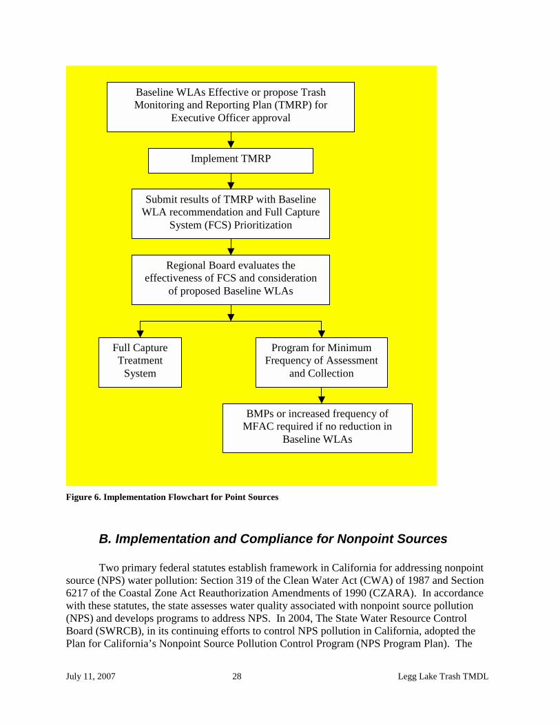
A. Implementation and Compliance for Point Sources
Discharge of trash from storm drains to Legg Lake will be regulated through the Municipal NPDES Storm Water Permit for Los Angeles County and Caltrans (Table 7).
July 11, 2007 26 Legg Lake Trash TMDL
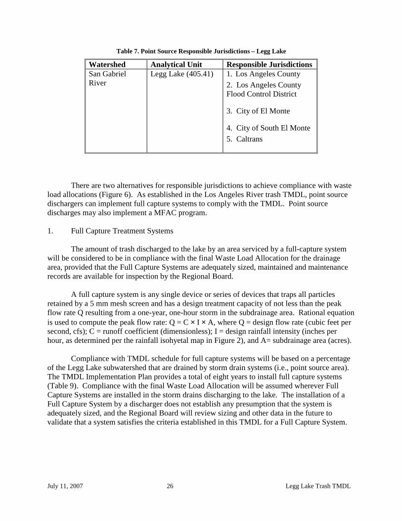
Table 7. Point Source Responsible Jurisdictions – Legg Lake
Watershed Analytical Unit Responsible Jurisdictions San Gabriel River
Legg Lake (405.41) 1. Los Angeles County 2. Los Angeles County Flood Control District
3. City of El Monte
4. City of South El Monte 5. Caltrans
There are two alternatives for responsible jurisdictions to achieve compliance with waste
load allocations (Figure 6). As established in the Los Angeles River trash TMDL, point source dischargers can implement full capture systems to comply with the TMDL. Point source discharges may also implement a MFAC program. 1. Full Capture Treatment Systems
The amount of trash discharged to the lake by an area serviced by a full-capture system will be considered to be in compliance with the final Waste Load Allocation for the drainage area, provided that the Full Capture Systems are adequately sized, maintained and maintenance records are available for inspection by the Regional Board.
A full capture system is any single device or series of devices that traps all particles
retained by a 5 mm mesh screen and has a design treatment capacity of not less than the peak flow rate Q resulting from a one-year, one-hour storm in the subdrainage area. Rational equation is used to compute the peak flow rate: Q = C × I × A, where Q = design flow rate (cubic feet per second, cfs); C = runoff coefficient (dimensionless); I = design rainfall intensity (inches per hour, as determined per the rainfall isohyetal map in Figure 2), and A= subdrainage area (acres).
Compliance with TMDL schedule for full capture systems will be based on a percentage
of the Legg Lake subwatershed that are drained by storm drain systems (i.e., point source area). The TMDL Implementation Plan provides a total of eight years to install full capture systems (Table 9). Compliance with the final Waste Load Allocation will be assumed wherever Full Capture Systems are installed in the storm drains discharging to the lake. The installation of a Full Capture System by a discharger does not establish any presumption that the system is adequately sized, and the Regional Board will review sizing and other data in the future to validate that a system satisfies the criteria established in this TMDL for a Full Capture System.

July 11, 2007 27 Legg Lake Trash TMDL
2. Program for Minimum Frequency of Assessment and Collection (MFAC)
Compliance with the final waste load allocations may also be attained whenever the minimum frequency for assessment and collection is implemented by responsible jurisdictions in conjunction with implementation of BMPs that attain the Baseline waste load allocations. For the Legg Lake TMDL, the minimum frequency is once per day. Assessment will be conducted at accessible areas and the outlet of the lake as defined in the Trash Monitoring and Reporting Plan. Collection is defined as removing 100% of the trash found on the lake and lakeshore and depositing it in a trash receptacle for proper disposal. If amount of trash collected exceeds Baseline Waste Load Allocations, then responsible jurisdictions must implement structural and/or non-structural BMPs to ensure that trash loaded to the lake is not increasing over time. Progressive reductions in trash will be calculated as follows:
At the effective date of the TMDL, the Baseline Waste Load Allocations will apply based on data collected by the Los Angeles Litter Management Plan. The first compliance point will be at the end of the third year with Waste Load Allocations equal to a 10% reduction of the amount of trash in the Baseline Waste Load Allocation. Compliance thereafter will be evaluated at the end of each successive storm season with Waste Load allocations equal to successive 20% reductions of the Baseline Waste Load Allocation (Table 10).
Dischargers will be deemed in compliance with the final Waste Load Allocation upon
results of the trash monitoring and reporting program demonstrating that any trash accumulating between MFAC events is not causing deleterious effects on the beneficial uses of Legg Lake. The amount of trash accumulated on the lake and lakeshore between MFAC events must progressively decline by 50% from the Baseline WLA over eight years. If the amount of trash accumulated does not progressively decrease, then responsible jurisdictions must implement additional structural and/or non-structural BMPs or increase frequency of MFAC to ensure reductions. The Regional Board may revise the TMDL schedule and the Minimum Frequency of the MFAC program based on the results of the trash monitoring and reporting program.
July 11, 2007 28 Legg Lake Trash TMDL
Figure 6. Implementation Flowchart for Point Sources
B. Implementation and Compliance for Nonpoint Sources
Two primary federal statutes establish framework in California for addressing nonpoint source (NPS) water pollution: Section 319 of the Clean Water Act (CWA) of 1987 and Section 6217 of the Coastal Zone Act Reauthorization Amendments of 1990 (CZARA). In accordance with these statutes, the state assesses water quality associated with nonpoint source pollution (NPS) and develops programs to address NPS. In 2004, The State Water Resource Control Board (SWRCB), in its continuing efforts to control NPS pollution in California, adopted the Plan for California’s Nonpoint Source Pollution Control Program (NPS Program Plan). The
Full Capture Treatment
System
Program for Minimum Frequency of Assessment
and Collection
Baseline WLAs Effective or propose Trash Monitoring and Reporting Plan (TMRP) for
Executive Officer approval
Implement TMRP
Submit results of TMRP with Baseline WLA recommendation and Full Capture
System (FCS) Prioritization
Regional Board evaluates the effectiveness of FCS and consideration
of proposed Baseline WLAs
BMPs or increased frequency of MFAC required if no reduction in
Baseline WLAs

July 11, 2007 29 Legg Lake Trash TMDL
NPS Program Plan prescribes implementation and monitoring of Best Management Practices to address nonpoint source pollution.
To implement this TMDL for nonpoint source dischargers, the Regional Board, with the adoption of this TMDL, waives waste discharge requirements for nonpoint source dischargers who submit a MFAC program for approval by the Executive Officer. The MFAC program includes a trash assessment of trash on the surface or shoreline of Legg Lake, collection of all visible trash that accumulates on the surface or shoreline of Legg Lake, and implementation of BMPs to attain a progressive reduction of the amount of trash collected at each collection event. Conditional waivers identify areas where best management practices need to be upgraded to attain water quality objectives in receiving waters. The monitoring plan submitted by responsible jurisdictions (Table 8) will provide data that may be used to propose an appropriate Baseline Load Allocation. The annual reduction from the Baseline Load Allocation serves as the criteria of allowable trash to be collected from the lake. Table 8. Nonpoint Source Responsible Jurisdictions – Legg Lake
Watershed Analytical Units Responsible Jurisdictions San Gabriel River
Legg Lake (405.41) Los Angeles County
Load Allocations shall be implemented through either (1) a conditional waiver from
waste discharge requirements, or (2) an alternative program implemented through waste discharge requirements or an individual waiver or another appropriate order of the Regional Board.
Non-point source dischargers may achieve compliance with the Load Allocations by
implementing a MFAC/BMP program approved by the Executive Officer. Responsible jurisdictions that are listed as both point and nonpoint sources will be deemed in compliance with both the Waste Load and Load Allocations if an MFAC/BMP program, approved by the Executive Officer, is implemented.
The MFAC/BMP Program includes an initial minimum frequency of trash assessment
and collection and suite of structural and/or nonstructural BMPs. The MFAC/BMP program shall include collection and disposal of all trash found in the water and on the shoreline. Responsible jurisdictions shall implement an initial suite of BMPs based on current trash management practices in land areas that are found to be sources of trash to Legg Lake. For Legg Lake, the initial minimum frequency shall be set as follows:
1. Five days per week on the shoreline and on the Whittier Narrow Recreation Park Area.
2. Once per week on waters of Legg Lake. Assessment will be conducted at accessible areas and the outlet of the lake as defined in
the Trash Monitoring and Reporting Plan. Collection is defined as picking up 100% of trash and

July 11, 2007 30 Legg Lake Trash TMDL
depositing it in a trash receptacle for proper disposal. All trash collected during the implementation of the MFAC, including trash from any channel cleaning and dredging operations, will be disposed of properly according to existing policies and regulations.
At the end of the implementation period, a revised MFAC/BMP program may be required if
the Executive Officer determines that the amount of trash accumulating between collections is causing nuisance or otherwise adversely affecting beneficial uses. Specifically, the Executive Officer may approve or require a revised assessment and collection frequency and definition of the critical conditions under the waiver:
(a) To prevent trash from accumulating in deleterious amounts that cause nuisance or adversely affect beneficial uses between collections;
(b) To reflect the results of trash assessment and collection; (c) If the amount of trash collected does not show a decreasing trend, where necessary, such
that a shorter interval between collections is warranted; or (d) If the amount of trash collected is decreasing such that a longer interval between
collections is warranted.
With regard to (a), (b) or (c), above, the Executive Officer is authorized to allow responsible jurisdictions to implement additional structural or non-structural BMPs in lieu of modifying the monitoring frequency.
Alternatively, responsible jurisdictions may propose, or the Regional Board may impose, an alternative program which would be implemented through waste discharge requirements an individual waiver, a cleanup and abatement order, or any other appropriate order or orders, provided the program is consistent with the assumptions and requirements of the reductions described in Table 10, below.
The Regional Board is adopting a Conditional Waiver for trash in Legg Lake at the same
time as this TMDL. The Conditional Waiver provides a regulatory structure whereby continued monitoring and iterative BMPs are deployed to attain zero trash within the TMDL Implementation Schedule. Based on the trash generation rate derived from the TMRP after the second year of implementation, the Regional Board will consider the proposal of a site specific Load Allocation for Legg Lake (Table 10).

July 11, 2007 31 Legg Lake Trash TMDL
Figure 7. Implementation Flowchart for Nonpoint Sources
C. Coordinated Compliance
Responsible jurisdictions for this TMDL include both point source and nonpoint source dischargers. Compliance with the TMDL may be based on a coordinated Monitoring and Reporting work plan that outlines TMDL responsibilities for each responsible jurisdiction. Dischargers interested in coordinated compliance shall submit a Coordinated Monitoring and Reporting Compliance plan that outlines BMPs that will be implemented and the schedule for implementing the BMPs and MFAC program.
D. Non-Structural BMPs
A wide variety of methods possibly alleviating trash impairment to Legg Lake are listed below. Responsible jurisdictions shall propose the monitoring plan as well as the mitigation measures incorporating an individual method or combinations to progressively reduce nonpoint
Baseline LAs Effective or propose Trash Monitoring and Reporting Plan (TMRP) for Executive Officer
approval
Implement TMRP
Submit results of TMRP with Baseline LA recommendation and Full Capture System (FCS)
Prioritization
Regional Board evaluates the effectiveness of FCS and consideration of proposed Baseline LAs
Program for Minimum Frequency of Assessment and Collection
Structural and/or Non-Structural BMP required if Baseline LAs and Progressive Reduction
Schedule are attained

July 11, 2007 32 Legg Lake Trash TMDL
source trash. Non-structural BMPs may provide advantages over structural full capture systems in areas that are not extensively drained by municipal separate storm water sewer systems. Foremost, institutional controls offer other societal benefits associated with reducing litter in our city streets, parks and other public areas. The capital investment required to implement non-structural BMPs is generally less than for full capture systems.
Litter Control
It is noted that ordinances prohibiting littering are already in place in the area of Legg Lake. For example, Los Angeles County Ordinance No. 12.80.440, “Littering and Other Discharge of Polluting or Damaging Substances Prohibited,” states
“No person shall cause any refuse, rubbish, food waste, garbage, or any other discarded or abandoned objects to be littered, thrown, deposited, placed, left, accumulated, maintained or kept in or upon any street, alley, sidewalk, storm drain, inlet, catch basin, conduit, drainage structure, place of business, or upon any public or private property except when such materials are placed in containers, bags, recycling bins, or other lawfully established waste disposal facilities protected from stormwater or runoff.”
In addition, Caltrans Ordinance No. D1.02, “Laws That Pertain to Litter, Debris,” states,
“A. Throwing Lighted Substances Vehicle Code Section 23111 provides that no one may throw or discharge onto the highway or adjacent area any lighted or unlighted cigarette, cigar, match, or flaming or glowing substance.” “B. Disposing of Litter or Garbage on Highway
Vehicle Code Section 23112 provides that no one may throw or deposit on the highway any garbage or substance likely to injure or damage traffic using the highway, or any noisome, nauseous, or offensive matter of any kind. It also prohibits the placement of any rock, refuse, or dirt within the highway right of way.”
Trash Receptacles
Most of trash disposed of on the ground may result from the lack of trash receptacles. Installing trash receptacles can reduce nonpoint trash loadings. The receptacles shall be visible and conveniently reachable for all park users. During the picnic seasons, sufficient trash and hot coal receptacles in the picnic area should be provided. Receptacles shall equip with lids to prevent the wildlife browsing through or the wind re-mobilizing the trash inside. Receptacles may be decorated but shall not cause visual intrusion to the background environment.
Varieties of land uses determine the proper locations and necessary density of the trash
receptacles. More receptacles are needed along trails, near park entrances and exits, adjacent to picnic areas or areas with higher activity frequencies. Sanitation should be maintained to avoid nuisances.
July 11, 2007 33 Legg Lake Trash TMDL
Enforcement of Litter Laws The existing litter laws shall be post in the prominent location for the park users or
resident to understand the regulations. It is to be noted that ordinances that prohibit litter are already in place in most cities because cities recognize that trash has become a pollutant in the storm drain system when exposed to storm water or any runoff, and prohibit the disposal of trash on public land. Patrolling or designated personnel shall have authorities to illustrate, execute, and enforce the litter laws. The effectiveness of enforcement should be monitored.
Trash Bags
Trash bags may be provided at the park entrance for visitors to keep their trash contained. Trash bags should be available at designated locations for park users to collect after their activities or pets. The concept of trash bags originates from the trash bags offered in the Los Angeles mass transportation system which provides trash bags in the buses for passengers to keep the buses clean. This program may be more effective if it combines with other encouragement. The effectiveness shall be monitored by finding the use of these trash bags in the trash collectors or trash receptacles.
Street Sweeping
Street sweeping is one of most effective methods to keep debris, vegetation wastes, and trash away from catch basins. Although the correlation between street sweeping frequency and amount of trash collected in the waterbody is not confirmed in the Legg Lake area, it is convincing that more street sweeping will allow less trash to be flushed by storm water to the catch basins, and to be discharged to waterbodies of concern.
Most municipalities have been undergoing or have had contracts with Los Angeles
County for street sweeping program. In the County’s unincorporated areas, street sweeping frequency may be increased to reduce trash loading.
Public Education
Public education refers to posting information, giving presentation, or conducting direct or indirect communication with individuals. This outreach should be applied to public entities such as city halls, schools, community centers, senior centers, and to private meeting/activity locations. The educational materials should include the relevant ordinances, the importance of protecting environment, possible environmental and biological impacts from pollution, and the necessary response if pollution occurs.
Community Involvement
Involving communities may be more effective in promoting the importance of protecting water quality and environment. The bonding between residents and community makes the community more influential in educating residents of right concepts. Communities can organize activities to illustrate that environmental protection involves every individual’s continuous efforts.
Recycling Program
A Recycling program shall be developed to minimize trash sources in the vicinity of the waterbody of concern.
July 11, 2007 34 Legg Lake Trash TMDL
Reporting System
Patrol personnel, park users, or residents should report accumulation of trash or illegal disposal of trash to the waterbodies and their adjacent areas. Information with a toll-free number and communication devise shall be conveniently available near the waterbodies for timely reporting. Responsible jurisdictions, after receiving reports, should conduct inspections to formulate proper cleanup actions.
Stencil
Stencils are to remind the residents and park users of the importance of maintaining water quality and of the existing ordinances. Signs should be placed in prominent locations where most people will view them, and should contain appropriate symbols as well as clear written messages, and cite the appropriate federal, state and county codes including the largest possible penalty amount for violation of codes.
Consideration of Picnic Area Relocation
Trash found in the waterbodies may be the results of storm water flushing or wind re-mobilizing trash originally disposed of around picnic areas. If storm water or wind is the dominant factor causing trash impairment, and trash is constantly found near picnic areas, it may be a solution to reconsider the proper location of picnic area.
The further the picnic area away from waterbodies, the longer time or more mobilization
energy it needs from storm water or wind to carry trash to waterbodies of concerns. Trash may be cleaned before reaching waterbodies. A proper monitoring period to analyze the cause of trash is necessary prior to considering this option.
Imposition of Trash Tax
The trash often discovered on or adjacent to the waterbodies is convenient paper or plastic food or beverage containers, plastic bottles, paper plates, aluminum cans, or plastic bags. This trash shares the same characteristics as packaging utilized in the fast food stores. The evidence of trash causing the waterbody impairment may be used to justify an increase in retail price of disposable food or beverage packaging to compensate the potential environmental impacts. The additional tax income can contribute to preventive or cleanup actions for the designated waterbody of concern.
Cooperation of Potential Sources of Trash
Stores carrying goods considered potential sources of trash to the waterbody or its adjacent areas can advise their patrons to handle the packaging, residuals or any trash parts in an environmentally friendly manner. Similar to the stencils, signs with clear language containing ordinances, and a penalty of violation should be posted near the cashier, exit and parking lot.
Surveillance Camera
Surveillance cameras can be installed to monitor the water quality and any illegal disposal which may require immediate cleanup. They can also be used to enforce the littering laws if necessary.

July 11, 2007 35 Legg Lake Trash TMDL
Tax Benefit by Adopting Waterbodies, Parks, etc. This concept is adapted from “adopt a highway” program. The participation from
industries in the vicinity of lakes, rivers, or creeks, will help the responsible jurisdictions to maintain the cleanliness of the environment, and increase the cleaning frequency. Industries or any entities that contribute resources, time, or efforts to keep the environment clean could be encouraged by having tax benefit.
E. Implementation Schedule
The TMDL Implementation Schedule is designed to provide permittees and responsible jurisdictions flexibility to implement structural and non-structural BMPs to address the trash impairment of Legg Lake. Implementation consists of development of monitoring plans by permittees and responsible jurisdictions and implementation of the Executive Officer approved TMRP. Table 9. Full Capture Implementation Schedule
Task No.
Task Responsible Jurisdiction Date
1 Submit Trash Monitoring and Reporting Plan, including a plan for defining the trash baseline WLA and a proposed definition of “major rain event”.
Los Angeles County, Los Angeles County Flood Control Districts, the Cities of El Monte and South El Monte, and Caltrans.
6 months from effective date of TMDL. If a plan is not approved by the Executive Officer within 9 months, the Executive Officer will establish an appropriate monitoring plan.
2 Implement Trash Monitoring and Reporting Plan.
Los Angeles County, Los Angeles County Flood Control Districts, the Cities of El Monte and South El Monte, and Caltrans.
6 months from receipt of letter of approval from Regional Board Executive Officer, or the date a plan is established by the Executive Officer.
3 Submit results of Trash Monitoring and Reporting Plan, recommend trash baseline WLA, and propose Full Capture System
Los Angeles County, Los Angeles County Flood Control Districts, the Cities of El Monte and South El Monte, and Caltrans.
2 years from receipt of letter of approval for the Trash Monitoring and Reporting Plan from Regional Board Executive Officer.

July 11, 2007 36 Legg Lake Trash TMDL
prioritization. 4
Installation of Full Capture Systems to achieve 20% reduction of trash from Baseline WLA*.
Los Angeles County, Los Angeles County Flood Control Districts, the Cities of El Monte and South El Monte, and Caltrans.
Four years from effective date of TMDL.
5
Installation of Full Capture Systems to achieve 40% reduction of trash from Baseline WLA*.
Los Angeles County, Los Angeles County Flood Control Districts, the Cities of El Monte and South El Monte, and Caltrans.
Five years from effective date of TMDL.
6 Evaluate the effectiveness of Full Capture Systems, and reconsider the WLA.
Regional Board. Five years from effective date of TMDL.
7
Installation of Full Capture Systems to achieve 60% reduction of trash from Baseline WLA*.
Los Angeles County, Los Angeles County Flood Control Districts, the Cities of El Monte and South El Monte, and Caltrans
Six years from effective date of TMDL.
8
Installation of Full Capture Systems to achieve 80% reduction of trash from Baseline WLA*.
Los Angeles County, Los Angeles County Flood Control Districts, the Cities of El Monte and South El Monte, and Caltrans
Seven years from effective date of TMDL.
9
Installation of Full Capture Systems to achieve 100% reduction of trash from Baseline WLA*.
Los Angeles County, Los Angeles County Flood Control Districts, the Cities of El Monte and South El Monte, and Caltrans.
Eight years from effective date of TMDL.
*Compliance with percent reductions from the Baseline WLA will be assumed wherever full capture systems are installed in corresponding percentages of the conveyance discharging to the waterbody. Installation will be prioritized based on the greatest point source loadings.

July 11, 2007 37 Legg Lake Trash TMDL
Table 10. Minimum Frequency Assessment and Collection Implementation Schedule
Task No.
Task Responsible Jurisdiction Date
1 Conditional Waiver in effect.
Los Angeles County, City of South El Monte, City of El Monte.
Regional Board adoption of TMDL.
2 Submit Notice of Intent to Comply with Conditional Waiver of Discharge Requirements, including MFAC/BMP Program and Trash Monitoring and Reporting Plan.
Los Angeles County, City of South El Monte, City of El Monte.
Six months from TMDL effective date.
3 Implement MFAC/BMP Program.
Los Angeles County, City of South El Monte, City of El Monte.
Six months from receipt of Notice of Acceptance from Regional Board Executive Officer.
4 Submit annual TMRP reports including proposal for revising MFAC/BMP for Executive Officer approval.
Los Angeles County, City of South El Monte, City of El Monte.
Two years from effective date of TMDL, and annually thereafter.
5
Reconsideration of Trash TMDL based on evaluation of effectiveness of MFAC/BMP program.
Regional Board. Five years from effective date of TMDL.
* At Task 3, all Responsible Jurisdictions must be attaining the zero trash target after each required trash assessment and collection event. At Task 4, all Responsible Jurisdictions must demonstrate full compliance and attainment of the zero trash target between the required trash assessment and collection events. Based on Responsible Jurisdiction monitoring reports, the Executive Officer may adjust the minimum frequency of assessment and collection as necessary to ensure compliance between the required trash assessment and collection events.

July 11, 2007 38 Legg Lake Trash TMDL
F. Reasonably Foreseeable Environmental Impacts from TMDL Implementation
An accompanying CEQA Substitute Environmental Document (SED) analyses the
potential negative environmental impacts of compliance with the trash TMDL based on the implementation strategies discussed above. According to municipalities implementing previous Trash TMDL requirements by installing catch basin inserts and vortex separation devices, it was found the most significant environmental impacts result from construction activities associated with installation and maintenance activities. The primary construction impacts are caused by concrete and electrical work, and in some areas, earth work associated with structural improvements. The environmental impacts are resulting from maintaining, removing and disposing trash from structural treatment systems. Both constructional and environmental impacts may be mitigated by available technologies.
Regarding cumulative impacts, it is noted that both the construction and maintenance activities are in small, discrete, discontinuous areas over a short duration. Consequently, cumulative impacts are not significantly exacerbated from the sum of individual project impacts. Project level environmental analysis for implementation of structural methods will likely be conducted by municipalities and responsible jurisdictions under notices of exemption. Categorical exemptions will be based on the nature of the projects including:
-Minor alteration of existing public structures involving negligible expansion of an existing facility. -Modifications of existing storm drain system and addition of environmental protection devices in existing structures with negligible or no expansion of use. -Modifications to sewers constructed to alleviate a high potential or existing public health hazard.
The analysis concludes that the implementation of this TMDL will result in water quality
improvement in Legg Lake, but may be associated with temporary or permanent localized adverse impacts to the environment. While specific projects employed to implement the TMDL may have significant impacts, these impacts may be limited, short-term or mitigated through effective design and scheduling. Under circumstances that none of alternatives or mitigation measures is available to mitigate the environmental impact caused by implementation of this Trash TMDL, implementing this Trash TMDL would outweigh the unavoidable adverse environmental effects because the minimum foreseeable environmental impacts shall be addressed by project level planning, construction, and operation methods as described in the CEQA SED.
July 11, 2007 39 Legg Lake Trash TMDL
X. Monitoring
Assessment and monitoring of trash are key components of the TMDL. The goal of trash monitoring is to collect representative data from across the watershed that can be used to refine Baseline Load and Waste Load Allocations, effectively site and design BMPs, including full capture systems, and determine compliance with Waste Load and Load Allocations. Monitoring activities and results, including implementation and effectiveness of BMP implementation, will be reported and submitted to the Regional Board on an annual basis. Responsible jurisdictions will be required to propose and implement a Trash Monitoring and Reporting Plan approved by the Executive Officer.
The Trash Monitoring and Reporting Plan will describe the methodologies that will be
used to assess and monitor trash in Legg Lake, and if applicable land areas in the vicinity of Legg Lake. Regional Board staff finds that monitoring protocols prescribed by the Rapid Trash Assessment are appropriate for this TMDL. Elements of the trash Monitoring and Reporting Plan are described below.
• Monitoring Plan. Responsible jurisdictions will submit a Trash Monitoring and
Reporting Plan with the proposed monitoring sites and at least two additional alternate monitoring locations. The Work Plan must include maps of the drainage and storm drain data, and locations where most trash accumulated on the waterbody and on the vicinities for nonpoint sources for each proposed and alternate monitoring location. The monitoring plan(s) will be submitted to the Regional Board according the TMDL Implementation Schedule. The Regional Board's Executive Officer will have full authority to review the monitoring plan(s), to modify the plan, to select among the alternate monitoring sites, and to approve or disapprove the plan(s).
• Jurisdiction. Allocations will be permitted through storm water permits or by a
Conditional Waiver. For this reason, each responsible jurisdiction must provide the Regional Board list of entities located within their municipal boundaries that are outside of their jurisdiction including state or federal lands and facilities.
• Data Collection. Baseline data may be collected over a period of two years.
Although the amount of trash deposited into the waterbodies through storm drains or from nonpoint sources may depend on rainfall patterns and winds, monitoring will include dates in both the rainy season and the dry season. The Los Angeles County Department of Public Works defines the rainy season as spanning from October 15 to April 15.
• Unit of Measure. Data will be reported in a single unit of measure that is
reproducible and measures the amount of trash, irrespective of water content (e.g., compacted volume based on a standardized compaction rate, dry weight, etc.). The responsible jurisdictions may select the unit. The unit of measure used during Baseline Monitoring also will be used during Implementation for determining compliance with Waste Load Allocations and Load Allocations.

July 11, 2007 40 Legg Lake Trash TMDL
• Vegetation. The responsible jurisdictions may exclude vegetation from their reported discharge except where there is evidence that the vegetation is the result of the illegal discharge of yard waste. However, all monitoring data must be reported uniformly (either with or without vegetation). If the permittees include vegetation in the discharges reported during Baseline Monitoring, they will be obligated to include natural vegetation in their reports of discharge during Implementation.
• Disposal of Collected Trash. Trash captured during the monitoring plan must be
disposed of in accordance with all applicable laws and regulations.
• Location. Trash monitoring on the surface and lakeshore of Legg Lake shall be focus on visible trash at representative and critical locations determined by the Discharger and approved by the Executive Officer in the Trash Monitoring and Reporting Workplan. Locations for trash assessment shall include, but not be limited to locations where trash enters and exits the lake, accumulates on the lakeshore, and areas of recreational access and wildlife habitat. Trash assessment of the lake and lakeshore shall include the type of trash, amount of trash according to a metric proposed and approved in the Monitoring and Reporting Workplan.
• Representative Data. In an effort to provide representative data in deriving Baseline
Waste Load Allocation and Baseline Load Allocation, the minimum requirements to establish the Trash Monitoring and Reporting Plan include:
• The plan would provide representative data from across the watershed. • The plan would provide data in units that were easily reproducible and
would be comparable with data to be collected during the Implementation Phase.
• The Baseline Waste Load Allocation and Baseline Load Allocation may be revised from data generated from the plan.
• Land Use Areas. Dischargers may propose trash monitoring according to Land Use
Areas in the vicinity of Legg Lake. Monitoring data can be used to establish specific trash generation rates per land use for siting and design of BMPs.
The requirements and milestone dates related to the Trash Monitoring and Reporting
Plan are summarized in Table 11.
Table 11. Trash Monitoring and Reporting Plan Due Dates

July 11, 2007 41 Legg Lake Trash TMDL
Task Completion Date
Submit Trash Monitoring and Reporting Plan, including a plan for defining the trash baseline WLA and a proposed definition of “major rain event”.
6 months from effective date of TMDL. If a plan is not approved by the Executive Officer within 9 months, the Executive Officer will establish an appropriate monitoring plan.
Implement Trash Monitoring and Reporting Plan.
6 months from receipt of letter of approval from Regional Board Executive Officer, or date a plan is established by the Executive Officer.
Submit results of Trash Monitoring and Reporting Plan, recommend trash baseline WLA, and propose Full Capture System prioritization.
2 years from receipt of letter of approval for the Trash Monitoring and Reporting Plan from Regional Board Executive Officer.
In addition to the general monitoring requirements, two TMDL Monitoring Strategies are outlined below for the proposed compliance options.
1. Monitoring of full capture devices.
Monitoring of full capture devices focuses on description and quantification of trash collected by the full capture devices and assessment of full capture device effectiveness in reducing trash in and on the shoreline of Legg Lake. The Monitoring and Reporting Plan will describe how trash collected from full capture devices will be quantified and how trash reductions in the lake and on the lakeshore will be assessed.
2. Minimum Frequency of Assessment and Collection
Responsible jurisdictions must identify at least 5 monitoring locations within the perimeter of the lake, including two (2) locations where trash was always present according to the records. The plan should describe how proposed monitoring locations will demonstrate how all visible trash on the lake and lakeshore can be assessed and collected. These observation locations must be inspected daily.

July 11, 2007 42 Legg Lake Trash TMDL
An additional 5 locations on the lake vicinity or in the park that are suspected to have the
most trash deposited on the ground shall also be checked on a daily basis. Responsible jurisdictions must collect 100% of the trash accumulated at the monitoring locations between MFAC events.
The report submitted for Regional Board’s review must contain information, including but not limited to dates of inspection, descriptions of trash types, estimate of trash quantity if weighting is not available, and immediate action of trash removal. At least one photo at each designated observation location per month must be taken and attached in the report to support the observation.
XI. Future Growth
It is reasonably foreseeable that as the population density in areas near Legg Lake increases, the trash loads to the lake will also increase. The TMDL addresses potential increased trash loading from future growth through several mechanisms including a numeric target of zero trash, WLAs and LAs of zero trash, and TMDL compliance mechanisms such as full capture systems and a specified MFAC program.
XII. Cost Considerations
Porter-Cologne Section 13241(d) requires staff to consider costs associated with the establishment of water quality objectives. The TMDL does not establish water quality objectives, but is merely a plan for achieving existing water quality objectives. Therefore cost considerations required in Section 13241 are not required for this TMDL.
The purpose of this cost analysis is to provide the Regional Board with information concerning the potential cost of implementing this TMDL and to addresses concerns about costs that have been raised by responsible parties. This section takes into account a reasonable range of economic factors in fulfillment of the applicable provisions of the California Environmental Quality Act (Public Resources Code Section 21159.)
An evaluation of the costs of implementing this Trash TMDL amounts to evaluating the costs of preventing trash from getting from the storm drain to Legg Lake. This brief report gives a summary overview of the costs associated with the most likely ways the responsible jurisdictions will achieve the required reduction in discharges to the storm drain system. Such an analysis would be incomplete if it failed to consider the existing cost that presently is transferred to "innocent" downstream communities. There is an unquantified cost to aquatic life within Legg Lake. Cost of Implementing Trash TMDL

July 11, 2007 43 Legg Lake Trash TMDL
The reference provided by Los Angeles County indicated that it cost more than 4 million dollars to clean trash from 31-mile beaches annually. City of Long Beach, at the mouth of the Los Angeles River, also spent almost 1 million dollars annually for storm debris accumulated in the Long Beach Harbor. These expenses should be taken into consideration while calculating the potential cost of implementing Trash TMDL.
The cost of implementing this TMDL will range widely, depending on the method that
the responsible parties select to meet the Waste Load and Load Allocations. Arguably, enforcement of existing litter ordinances could be used to achieve the final Waste Load Allocations at minimal or no additional cost. The most costly approach in the short-term is the installation of full capture systems on all discharges to Legg Lake.
Most of the information presented herein consists of catch basin inserts, structural vortex
separation devices and end of pipe nets. We are considering the costs associated with preventing the disposal of trash into the waterbodies of concern.
Regardless of the method(s) used, costs associated with the gradual decrease of the amount of trash in the waterbodies, and the maintenance of the Legg Lake and its tributaries free of trash include monitoring and implementation costs. Any device chosen for monitoring trash or removing trash from storm drain, regardless of its installation costs, will also be associated with labor costs.
We are looking at several methods separately, from retrofitting all the catch basins in the urbanized portion of the watershed, to using solely structural full capture methods.
1. Catch Basin Inserts
At a cost of around $800 per insert, catch basin inserts are the least expensive structural treatment device in the short term. However, because they are not a full capture method, they must be monitored frequently and must be used in conjunction with street sweeping.
Due to the lack of numbers of catch basins in the vicinity of Legg Lake, the average
density of 123 catch basin per square miles based on the reference provided by Los Angeles County Department of Public Works was applied to this subwatershed.
Approximately 125 catch basins are estimated in this subwatershed. Assuming all catch
basin insert will be installed in five years after the effective date of this TMDL, and the operation and maintenance expense is 50% of the installation cost, the costs in Table 12 are calculated.
Table 12. Costs of retrofitting the catch basin inserts (Dollars in thousands)
Number of years in the program
1 2 3 4 5 6 7 8
Operations and Maintenance (yearly,
$10 $20 $30 $40 $50 $50 $50 $50

July 11, 2007 44 Legg Lake Trash TMDL
cumulative) Capital Cost (yearly) $20 $20 $20 $20 $20 Annual Costs per year (Capital + Operation and Maintenance)
$30 $40 $50 $60 $70 $50 $50 $50
2. Full Capture Vortex Separation Systems (VSS)
Permanent structural devices can be used to trap gross pollutants for monitoring
purposes as well as implementation. Among those “litter control devices” are structural vortex separation systems (VSS), floating debris traps, end-of-pipe nets and trash racks. VSS units appear to be among the best alternatives to evaluate or remove the amount of trash generated throughout a particular drainage area.
An ideal way to capture trash deposited into a storm drain system would be to install a VSS unit. This device diverts the incoming flow of storm water and pollutants into a pollutant separation and containment chamber. Solids within the separation chamber are kept in continuous motion, and are prevented from blocking the screen so that water can pass through the screen and flow downstream. This is a permanent device that can be retrofitted for oil separation as well. Studies have shown that VSS systems remove virtually all of the trash contained in the treated water. The cost of installing a VSS is assumed to be high, so limited funds will place a cap on the number of units which can be installed during any single fiscal year.
The point sources area is approximately 650 acres. Table 13 provides capacities and the associated costs of various sizes of VSS. Staff assumes the cost of yearly servicing of a VSS unit to be $2000. Table 13. Costs Associated with VSS
Capacity Acres (average)
Unit Capital Cost Number of devices needed on urban
portion of watershed
Capital costs Yearly costs for servicing all
devices
1 to 2 cfs 5 $12,800 129 $1,651,200 $258,000
6 to 8 cfs 30 $45,000 21 $945,000 $42,000
19 to 24 cfs 100 $90,000 6 $540,000 $12,000
Tables 14 and 15 compare the estimated costs of retrofitting the point source areas with low capacity VSS (1 to 2 cfs) and large capacity VSS (19 to24 cfs), given that VSS will be installed within the first five years after the effective date of this TMDL.
Table 14. Costs Associated with Low Capacity Vortex Gross Pollutant Separation Systems (Dollars in thousands)

July 11, 2007 45 Legg Lake Trash TMDL
Number of years in the program
1 2 3 4 5 6 7 8
Units Installed 25 25 25 25 25 Operations and Maintenance (yearly, cumulative)
$50 $100 $150 $200 $250 $250 $250 $250
Capital Cost (yearly) $320 $320 $320 $320 $320 Annual Costs per year (Capital + Operation and Maintenance)
$370 $420 $470 $520 $570 $250 $250 $250
Table 15. Costs Associated with Large Capacity Vortex Gross Pollutant Separation Systems (Dollars in thousands)
Number of years in the program
1 2 3 4 5 6 7 8
Units Installed 1 1 1 1 1 Operations and Maintenance (yearly, cumulative)
$2 $4 $6 $8 $10 $10 $10 $10
Capital Cost (yearly) $90 $90 $90 $90 $90 Annual Costs per year (Capital + Operation and Maintenance)
$92 $94 $96 $98 $100 $10 $10 $10
Outfitting a large drainage with a number of large VSS systems may be less costly than using a larger number of small VSS systems. Maintenance costs decrease dramatically as the size of the system increases. Topographical and geotechnical considerations also should come into play when choosing VSS systems or other structural systems or devices. 3. End of Pipe Nets
“Release nets” are a relatively economical way to monitor trash loads from municipal drainage systems. However, in general, they can only be used to monitor or intercept trash at the end of a pipe and are considered to be partial capture systems, as the nets are usually sized at a 1/2" to 1" mesh. These nets are attached to the end of pipe systems. The nets remain in place on the end of the drain until water levels upstream of the net rise sufficiently to release a catch that holds the net in place. The water level may rise from either the bag being too full to allow sufficient water to pass, or from a disturbance during very high flows. When the nets release they are attached to the side of the pipe by a steel cable and as they are washed downstream (a yard or so) are tethered off so that no pollutants from within the bags are washed out.
Preliminary observations suggest that the nets rarely fill sufficiently to cause the bags to release. And therefore, if they are cleaned after a storm event, the entire quantity of material is captured and can be measured for monitoring purposes using two bags per trap. This makes it

July 11, 2007 46 Legg Lake Trash TMDL
easy to replace the full or partially full bag with an empty one, so that the first bag can be taken to a laboratory for analysis without manual handling of the material it contains.
The nets are valid devices because of the ease of maintenance and also because the devices can be relocated after a set period at one location (provided the pipe diameters are the same). With limited funding, installation could be spread over several land uses and lead to valuable monitoring results.
Because the devices require attachment to the end of a pipe, this can severely reduce the number of locations within a drainage system that can be monitored. In addition, these nets cannot be installed on very large channels (7 feet in diameter is the maximum). Thus costs shown in Table 16 are given per pipe, and no drainage coverage is given.
Table 16. Sample Costs for End of Pipe Nets
Pipe Size Release nets (cost estimates)
End of 3 ft pipe $10,000
End of 4 ft pipe $15,000
End of 5 ft pipe $20,000
In 3 ft pipe network $40,000
In 4 ft pipe network $60,000
In 5 ft pipe network $80,000 4. Cost Consideration – Minimum Frequency ofTrash Assessment and Collection
This section provides a brief estimate of costs to comply with the Minimum Frequency of Assessment and Collection. The cost estimate is based on the Minimum Frequency of Assessment and Collection on a daily bases including weekends. It is also assumed that the personnel for trash assessment and collection will be employed by one of the agencies that provide services to the area of Legg Lake. As such, equipment and vehicles are available and costs for these items are assumed to be included in the estimate below. It is also assumed that a single person can conduct the complete trash assessment and collection in four hours at each cleanup. Consequently, the total time per year to conduct the Minimum Frequency of Assessment and Collection is 182.5 days.
Assuming a burdened hourly rate of $37.50 per hour, the estimated annual costs to the
Minimum Frequency Assessment and Collection is $54,600 for Legg Lake.
5. Cost Comparison
A comparison of costs between strategies based on catch basin inserts (CBIs), low capacity VSS, high capacity VSS systems, and enforcement of litter laws is presented in Table

July 11, 2007 47 Legg Lake Trash TMDL
17. This comparison was completed for a trash TMDL in the Los Angeles River watershed. Staff assumes the relative magnitude of the costs for the different options is applicable for the Legg Lake TMDL, with an addition of the cost resulting from Minimum Frequency of Assessment and Collection. Table 17. Cost Comparison (amounts in millions)
CBI only Low capacity VSS Units
Large capacity VSS Units
Minimum Frequency Trash Assessment and
Collection
Enforcement of Litter Laws1
Cumulative capital costs over 8 years
$0.1 $1.6 $0.06 $0 $0
Cumulative maintenance and capital costs after 8 years
$0.4 $3.1 $0.45 $0.44 $0
Annual servicing costs after full implementation
$0.05 $0.25 $0.51 $0.05 $0
Trash abatement in the Legg Lake will differ depending on the options selected by the responsible jurisdictions.
1 Revenues from fines assessed to offset increased law enforcement cost. The cost of a database system used to calculate trash discharges estimated to be less than $250,000.
July 11, 2007 48 Legg Lake Trash TMDL
XIII. Bibliography
Allison, R.A., Chiew, F.H.S., and McMahon, T.A. (1998) A Decision-Support-System for Determining Effective Trapping Strategies for Gross Pollutants. Cooperative Research Centre for Catchment Hydrology. Victoria.
Allison, R.A., Walker, T.A., Chiew, F.H.S., O’Neill, I.C., McMahon, T.A. (1998) From Roads to Rivers, Gross Pollutant Removal From Urban Waterways. Cooperative Research Centre for Catchment Hydrology. Victoria. California Department of Fish and Game, California Natural Diversity Database, updated October 2006. Http://www.dfg.ca.gov/bdb/html/cnddb_info.html Original Access November 15, 2006.
California State Water Resources Control Board, Environmental Protection Agency, Policy for Implementation and Enforcement of the Nonpoint Source Pollution Control Program, May 2004.
California Water Boards. (2007) A Rapid Trash Method Applied to Waters of the San Francisco Bay Region: Trash Measurement in Streams. Surface Water Ambient Monitoring Program. Danza, Jim. (1994) Water Quality and Beneficial Use Investigation of the Los Angeles River: Prospects for Restored Beneficial Uses. Masters Thesis, California State University. Fullerton.
Durrum, Emmett: The Control of Floating Debris in an Urban River. In Marine Debris: Sources, Impacts, and Solutions, Coe, James and Rogers, Donald, Eds. New York: Springer-Verlag, 1997.
Garrett, K.L. (1993) The Biota of the Los Angeles River. Los Angeles County Natural History Museum. Laist, D.W., and Liffmann, M., 2000. Impacts of Marine Debris: Research and Management Needs. Issue papers of the International Marine Debris Conference. Aug. 6-11, 2000. Honolulu, HI, pp16-29. Long Beach, Memorandum from Geoffrey Hall, Parks, Recreation and Marine, to Ed Putz, City Engineer. Los Angeles County, An Ordinance Amending Title 20 – Utilities of the Los Angeles County Code, Adopted by Board of Supervisors on January 9, 2007. Los Angeles County Sanitation Districts (LACSD) (2006) San Gabriel River Watershed-wide Monitoring Program.

July 11, 2007 49 Legg Lake Trash TMDL
Los Angeles Regional Water Quality Control Board, Conditional Waiver of Waste Discharge Requirements fro Discharges from Irrigatedd Land within the Los Angeles Region, 2005 Los Angeles Regional Water Quality Control Board, State of the Watershed – Report on Surface Water Quality, The Santa Clara River Watershed, April 2006. Los Angeles Regional Water Quality Control Board, Water Quality Control Plan – Basin Plan for the Coastal Watersheds of Los Angeles and Ventura Counties, June 1994. Lund, L.J., Anderson, M.A., and Amrhein, C. (December 1994), Evaluation of Water Quality for Selected Lakes in the Los Angeles Hydrologic Basin, Department of Soil and Environmental Sciences, University of California, Riverside.
Moore, C.J. (Algalita Marine Research Foundation), Moore, S.L., Leecaster, M.K., and Weisberg, S.B.(Southern California Coastal Water Research Project) Marine Debris in the North Pacific Gyre, 1999, with a Biomass Comparison of Neustonic Plastic and Plankton. (In preparation.)
Moore, S. L., D. Gregorio, M. Carreon, S. B. Weisberg, and M. K. Leecaster. In press. Composition and distribution of beach debris in Orange County, California. In: S.B. Weisberg (ed.), Southern California Coastal Water Research Project Annual Report 1999-2000. Southern California Coastal Water Research Project. Westminster, CA.
Moore, S.L. and Allen, M.J. (2000) Distribution of Anthropogenic and Natural Debris on the Mainland Shelf of the Southern California Bight. Marine Pollution Bulletin 40:83-88. Pennsylvania State, Department of Environmental Protection, Lake Erie Cleanup Inventories, Clears 7,700 Pounds of Trash from Shoreline, October 5, 2006. Http://www.depweb.state.pa.us/news/cwp
Ribic, C.A., Johnson, S.W., and Cole, C.A. (1997) Distribution, Type Accumulation, and Source of Marine Debris in the United States, 1989-1993. Pp. 35-47 in: Coe, J.M., and Rogers, D.B. (eds.), Marine debris: Sources, impacts, and solutions. Springer-Verlag. New York, NY. Saint, P.K., Hanes, T.L., Lloyd, W.J., Waterbodies, Wetlands and their Beneficial Uses in the Los Angeles Region (July 1993), California State University, Fullerton. Signal Hill, Comments on the Los Angeles River Trash TMDL and CEQA Document, August 21, 2006.
US Environmental Protection Agency (US EPA) (1992) Plastic Pellets in the Aquatic Environment: Sources and Recommendations. Washington D.C. EPA 842-B-92-010. US Environmental Protection Agency (US EPA) Region IX (1999) Whittier Narrows

July 11, 2007 50 Legg Lake Trash TMDL
Operable Unit, Interim Record of Decision Amendment, November 1999, Interim Record of Decision Amendment, San Gabriel Valley Superfund Site, Whittier Narrows Operable Unit http://yosemite.epa.gov/r9/sfund/r9sfdocw.nsf/webdisplay/oid-8873b9d07809312488256953005df00a?OpenDocument US Environmental Protection Agency (US EPA) 2001. Draft Assessing and Monitoring Floatable Debris. US Environmental Protection Agency (US EPA) 2002. The definition, Characterization and Sources of Marine Debris. Unite 1 of Turning the Tide on Trash, a Learning Guide on Marine Debris. US Environmental Protection Agency (US EPA) 2006, Region 9 Website, California Nonpoint Source Program, http://www.epa.gov/region09/water/nonpoint/cal/index.html
Walker, T.A., Allison, R.A., Wong, T.H.F., and Wooton, R.M (1999) Removal of Suspended Solids and Associated Pollutants by a CDS Gross Pollutant Trap. Cooperative Research Centre for Catchment Hydrology. Victoria.
Walker, T.A., Wong, T.H.F. (1999) Effectiveness of Street Sweeping for Storm water Pollution Control, Technical Report, Report 99/8, December 1999. Cooperative Research Centre for Catchment Hydrology. Victoria.

July 11, 2007 51 Legg Lake Trash TMDL
XIV. Appendix I
The land use classification was developed by Aerial Information Systems as a modified Anderson Land Use Classification and originally included 104 categories. The land use coverages were donated for GIS library use by Southern California Association of Governments (SCAG), and show land use for 2005. The coverages were map-joined into a single coverage by Teale Data Center. The Regional Board layers were aggregated from the TDC coverage into the land uses shown above. Critical land uses were mapped regardless of resolution limits. Critical land use units below 1 acre in size were mapped as 1-acre units.
Land Uses Description and subcategories of Each Land Use High Density Residential
High density single family residential and all multi family residential, mobile homes, trailer parks and rural residential high density.
Low Density Residential
Under 2 units per acre.
Public Facilities
government centers, police and sheriff stations, fire stations, medical health care facilities, religious facilities large enough to be distinguished on an aerial photograph, libraries, museums, community centers, public auditoriums, observatories, live indoor and outdoor theaters, convention centers which were built prior to 1990, communication facilities, and utility facilities (electrical, solid waste, liquid waste, water storage and water transfer, natural gas and petroleum)
Education Preschools and daycare centers, elementary schools, high schools, colleges and universities, and trade schools, including police academies and fire fighting training schools.
Transportation Airports, railroads, freeways and major roads (that meet the minimum mapping resolution of 2.5 acres), park and ride lots, bus terminals and yards, truck terminals, harbor facilities, mixed transportation and mixed transportation and utility.
Mixed Urban Mixed commercial, industrial and/or residential, and areas under construction or vacant in 1990.
Open Space and Recreation
Golf courses, local and regional parks and recreation, cemeteries, wildlife preserves and sanctuaries, botanical gardens, beach parks.
Agriculture Orchards and vineyards, nurseries, animal intensive operations, horse ranches. Water Open water bodies, open reservoirs larger than 5 acres, golf course ponds,
lakes, estuaries, channels, detention ponds, percolation basins, flood control and debris dams.
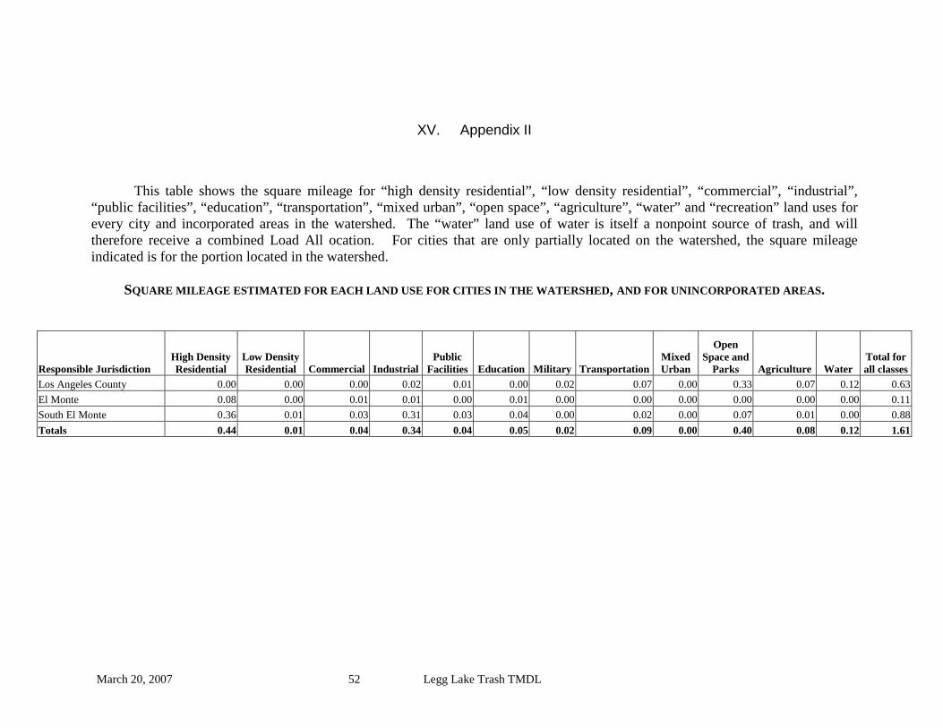
March 20, 2007 52 Legg Lake Trash TMDL
XV. Appendix II
This table shows the square mileage for “high density residential”, “low density residential”, “commercial”, “industrial”, “public facilities”, “education”, “transportation”, “mixed urban”, “open space”, “agriculture”, “water” and “recreation” land uses for every city and incorporated areas in the watershed. The “water” land use of water is itself a nonpoint source of trash, and will therefore receive a combined Load All ocation. For cities that are only partially located on the watershed, the square mileage indicated is for the portion located in the watershed.
SQUARE MILEAGE ESTIMATED FOR EACH LAND USE FOR CITIES IN THE WATERSHED, AND FOR UNINCORPORATED AREAS.
Responsible Jurisdiction High Density Residential
Low Density Residential Commercial Industrial
Public Facilities Education Military Transportation
Mixed Urban
Open Space and
Parks Agriculture Water Total for all classes
Los Angeles County 0.00 0.00 0.00 0.02 0.01 0.00 0.02 0.07 0.00 0.33 0.07 0.12 0.63 El Monte 0.08 0.00 0.01 0.01 0.00 0.01 0.00 0.00 0.00 0.00 0.00 0.00 0.11 South El Monte 0.36 0.01 0.03 0.31 0.03 0.04 0.00 0.02 0.00 0.07 0.01 0.00 0.88 Totals 0.44 0.01 0.04 0.34 0.04 0.05 0.02 0.09 0.00 0.40 0.08 0.12 1.61

March 20, 2007 53 Legg Lake Trash TMDL
XVI. Appendix III
This table shows the Waste Load and Load Allocations for trash per land use in each city base on square mileage. Waste Load Allocations are assigned to point source areas including high and low density residential, commercial, industrial, public Facilities, education, transportation and mixed urban land uses. Others of open space, agriculture, water and recreation land uses are considered as nonpoint sources and assigned with Load Allocation. For cities that are only partially located on the watershed, the square mileage indicated is for the portion located in the watershed.
WASTE LOAD ALLOCATIONS FOR TRASH PER LAND USE IN EACH CITY (GALLONS OF UNCOMPRESSED VOLUME)
Responsible Jurisdiction
High Density
Residential
Low Density
Residential Commercial Industrial Public
Facilities Education Military Transportation Mixed Urban
Open Space and
Parks Agriculture Water
Total for all classes
Los Angeles County 10.17 0.48 0.65 123.47 30.47 0.00 86.30 445.95 0.00 209.48 42.79 76.57 1026.33 El Monte 424.93 0.00 53.00 31.55 0.00 54.17 0.00 0.00 0.00 0.00 0.00 0.00 563.65 South El Monte 1918.77 30.11 138.99 1649.25 159.65 224.11 11.84 140.97 0.00 43.36 9.17 0.00 4326.21 Totals 2353.87 30.59 192.64 1804.26 190.12 278.29 98.14 586.92 0.00 252.85 51.96 76.57 5916.19
March 20, 2007 54 Legg Lake Trash TMDL
XVII. Definitions
The definitions of terms as used in this TMDL are provided as follows: Beneficial Uses. Beneficial Uses form the cornerstone of water quality protection under the Basin Plan. Once beneficial uses are designated, appropriate water quality objectives can be established and programs that maintain or enhance water quality can be implemented to ensure the protection of beneficial uses. The designated beneficial uses, together with water quality objectives (referred to as criteria in federal regulations), form water quality standards. Such standards are mandated for all waterbodies within the state under the California Water Code. In addition, the federal Clean Water Act mandates standards for all surface waters, including wetlands. Beneficial uses for Legg Lake are listed and defined below:
Municipal and Domestic Supply (MUN) - Uses of water for community, military, or individual water supply systems including, but not limited to , drinking water supply.
Ground Water Recharge (GWR) - Uses of water for natural or artificial recharge of ground water for purposes of future extraction, maintenance of water quality, or halting of saltwater intrusion into freshwater aquifers.
Water Contact Recreation (REC-1) - Uses of water for recreational activities involving body contact with water, where ingestion of water is reasonably possible. These uses include, but are not limited to, swimming, wading, water-skiing, skin and scuba diving, surfing, white water activities, fishing, or use of natural hot springs.
Non-contact Water Recreation (REC-2) - Uses of water for recreational activities involving proximity to water, but not normally involving body contact with water, where ingestion of water is reasonably possible. These uses include, but are not limited to, picnicking, sunbathing, hiking, beachcombing, camping, boating, tide pool and marine life study, hunting, sightseeing, or aesthetic enjoyment in conjunction with the above activities.
Warm Freshwater Habitat (WARM) - Uses of water that support warm water ecosystems including, but not limited to, preservation or enhancement of aquatic habitats, vegetation, fish, or wildlife, including invertebrates.
Cold Freshwater Habitat (COLD) – Uses of water that support cold water ecosystems including, but not limited to, preservation or enhancement of aquatic habitats, vegetation, fish or wildlife, including invertebrates.
Wetland Habitat (WET) – Uses of water that support wetland ecosystems, including, but not limited to, preservation or enhancement of wetland habitats, vegetation, fish, shellfish, or wildlife, and other unique wetland functions which

March 20, 2007 55 Legg Lake Trash TMDL
enhance water quality, such as providing flood and erosion control, stream bank stabilization, and filtration and purification of naturally occurring contaminants.
Wildlife Habitat (WILD) - Uses of water that support terrestrial ecosystems including, but not limited to, preservation and enhancement of terrestrial habitats, vegetation, wildlife (e.g., mammals, birds, reptiles, amphibians, invertebrates), or wildlife water and food sources.
Best Management Practices (BMPs). BMPs are the practice or combination of practices that are determined to be the most effective, practicable means of preventing or reducing the amount of pollution generated by point and nonpoint sources to a level compatible with water quality goals (including technological, economic, and institutional considerations). BMPs are defined in 40 CFR 122.2 as schedules of activities, prohibitions of practices, maintenance procedures, and other management practices to prevent or reduce the pollution of waters of the United States. In this TMDL, two general categories of structural BMPs and non-structural BMPs are discussed as possible means to reach “zero” trash goal. Full Capture Device. A full capture system is any single device or series of devices that traps all particles retained by a 5 mm mesh screen and has a design treatment capacity of not less than the peak flow rate Q resulting from a one-year, one-hour storm in the subdrainage area. Rational equation is used to compute the peak flow rate: Q = C × I × A, where Q = design flow rate (cubic feet per second, cfs); C = runoff coefficient (dimensionless); I = design rainfall intensity (inches per hour, as determined per the rainfall isohyetal map in Figure 2),2 and A= subdrainage area (acres). Baseline Load Allocation. The Baseline Load Allocation is analogous to the Baseline Waste Load Allocation for point sources, instead it is for nonpoint sources. Baseline Load Allocation is derived from the existing data, i.e. trash types and quantities, collected by responsible jurisdictions for various land uses. The progressive reductions in the Load Allocation will be determined based on the Baseline Load Allocation. Baseline Waste Load Allocation. The Baseline Waste Load Allocation is the Waste Load Allocation assigned to a permittee before reductions are required. The progressive reductions in the Waste Load Allocations could be based on a percentage or variable percentages of the Baseline Waste Load Allocation. The Baseline Waste Load Allocation was calculated based on the annual average amount of trash discharged to the storm drain system from a representative sampling of land use areas, as determined during the Trash Monitoring Plan.
Monitoring Entity. The Monitoring Entity is the permittee or one of multiple permittees and/or co-permittees that has been authorized by all the other affected permittees or co-permittees to conduct Baseline monitoring on their behalf.
2 The isohyetal map may be updated by the Los Angeles County hydrologist to reflect additional rain data. Updates published by the Los Angeles County Department of Public Works are prospectively incorporated by reference into this TMDL and accompanying Basin Plan amendment.

March 20, 2007 56 Legg Lake Trash TMDL
Nonpoint Source. It refers to diffuse, widespread sources of pollution. These sources may be large or small, but are generally numerous throughout a watershed. Nonpoint Sources include but are not limited to urban, agricultural, or industrial areas, roads, highways, construction sites, communities served by septic systems, recreational boating activities, timber harvesting, mining, livestock grazing, as well as physical changes to stream channels, and habitat degradation. NPS pollution can occur year round any time rainfall, snowmelt, irrigation, or any other source of water runs over land or through the ground, picks up pollutants from these numerous, diffuse sources and deposits them into rivers, lakes, and coastal waters or introduces them into ground water. Permittee. The term "permittee" refers to any permittee or co-permittee of a stormwater permit. Point Source. The term “point Source” means any discernible, confined and discrete conveyance, including but not limited to any pipe, ditch, channel, tunnel, conduit, well, discrete fissure, container, rolling stock, concentrated animal feeding operation, or vessel or other floating craft, from which pollutants are or may be discharged. This term does not include agricultural storm water discharges and return flows from irrigated agriculture. Trash. In this document, we are defining “trash” as man-made litter, as defined in California Government Code Section 68055.1(g):
“Litter means all improperly discarded waste material, including, but not limited to, convenience food, beverage, and other product packages or containers constructed of steel, aluminum, glass, paper, plastic, and other natural and synthetic materials, thrown or deposited on the lands and waters of the state, but not including the properly discarded waste of the primary processing of agriculture, mining, logging, sawmilling or manufacturing."
For purposes of this TMDL, we will consider trash to consist of litter and particles of litter, including cigarette butts. These particles of litter are referred to as “gross pollutants” in European and Australian scientific literature. This definition excludes sediments, and it also excludes oil and grease, and vegetation, except for yard waste that is illegally disposed of in the storm drain system. Additional TMDLs for sediments3 and oil and grease may be required at a later date.
Urbanized Portion of the Watershed. For the purposes of this TMDL, the urban portion of the watershed includes the sum of total areas of the incorporated cities and the partial unincorporated portion, which comprise of high and low density residential, commercial,
3 Sediments which may be addressed in a separate TMDL are natural particulate matters such as silt and sand. Sediments result from erosion and are deposited at the bottom of a stream. Sediments do not refer to the decomposition of settleable litter into small particulate matters, which this TMDL is trying to prevent.

March 20, 2007 57 Legg Lake Trash TMDL
industrial, mixed urban areas in Los Angeles County.4 The estimated areas of the “urbanized” portion of the watershed are summarized in the Appendix II.5 The remainder of the watershed is made up of the Angeles National Forest, agriculture and other open space.
4 The Regional Board recognizes that some areas within the unincorporated sections of Los Angeles County are actually suburban or rural. 5 As determined by the Regional Board from GIS mapping. (Other minor differences in figures are due to rounding.)


