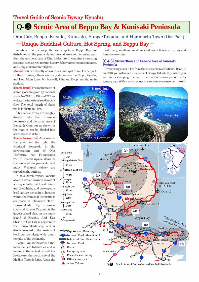
1 Travel Guide of Scenic Byway Kyushu Oita City, Beppu, Kitsuki, Kunisaki, Bungo-Takada, and Hiji-machi Town (Oita Pref.) ―Unique Buddhist Culture, Hot Spring, and Beppu Bay- As shown on the map, the scenic spots of Beppu Bay are distributed on the peninsula and coastal areas to the central part from the northern part of Oita Prefecture. It contains interesting contents such as rich nature, history & heritage since ancient ages, and unique mountain religions. [Access] You can directly access this scenic spot from Oita Airport. In the JR railway, there are many stations on the Nippo, Kyudai, and Hohi Main Lines, but basically Oita and Beppu are the main stations. [ Scenic Route] The main routes of scenic spots are given by national roads No.213, 10, 197 and 217, as well as the industrial road in Oita City. The total length of these roads is about 160 km. This scenic areas are roughly divided into the Kunisaki Peninsula and the urban area of Beppu & Oita, but as shown in the map, it can be divided into seven zones in detail. [Scenic Resaources] As shown in the photo on the right, the Kunisaki Peninsula in the northeastern part of Oita Prefecture has Futagoyama (721m) located upside down in the center of the peninsula, and many V-shaped valleys are carved on the surface. In this harsh region, various ascetics settled down in search of a unique faith that fused Shinto and Buddhists, and developed a local culture rooted in it. In other words, the Kunisaki Peninsula is composed of Hijimachi Town, Bungo-takada City, Kunisaki City, and Kitsuki City, and is the largest sacred place on the main- island of Kyushu. And, Usa Shrine in Usa City is adjacent to the Bungo-takada city, and is deeply involved in the creation of local culture along with many temples of the peninsula. Beppu Bay, on the other hand, faces the Seto Inland Sea and is located in the central part of Oita Prefecture, the north side of the Median Tectonic Line. Along the coast, many small and medium-sized rivers flow into the bay and form the coastline. (1) & (2) Showa Town and Seaside Area of Kunisaki Peninsula Proceeding about 5 km from the intersection of National Road 10 and 213, you will reach the center of Bungo-Takada City, where you will find a shopping mall with the motif of Showa period half a century ago. With a retro bonnet bus service, you can enjoy the old- Q-⓬ Scenic Area of Beppu Bay & Kunisaki Peninsula Q- ⓬ Scenic Area of Beppu Gulf and Kunisaki Peninsula. Beppu Bay Usa
Transcript
1
Travel Guide of Scenic Byway Kyushu
Oita City, Beppu, Kitsuki, Kunisaki, Bungo-Takada, and Hiji-machi Town (Oita Pref.)
―Unique Buddhist Culture, Hot Spring, and Beppu Bay- As shown on the map, the scenic spots of Beppu Bay are
distributed on the peninsula and coastal areas to the central part
from the northern part of Oita Prefecture. It contains interesting
contents such as rich nature, history & heritage since ancient ages,
and unique mountain religions.
[Access] You can directly access this scenic spot from Oita Airport.
In the JR railway, there are many stations on the Nippo, Kyudai,
and Hohi Main Lines, but basically Oita and Beppu are the main
stations.
[Scenic Route] The main routes of
scenic spots are given by national
roads No.213, 10, 197 and 217, as
well as the industrial road in Oita
City. The total length of these
roads is about 160 km.
This scenic areas are roughly
divided into the Kunisaki
Peninsula and the urban area of
Beppu & Oita, but as shown in
the map, it can be divided into
seven zones in detail.
[Scenic Resaources] As shown in
the photo on the right, the
Kunisaki Peninsula in the
northeastern part of Oita
Prefecture has Futagoyama
(721m) located upside down in
the center of the peninsula, and
many V-shaped valleys are
carved on the surface.
In this harsh region, various
ascetics settled down in search of
a unique faith that fused Shinto
and Buddhists, and developed a
local culture rooted in it. In other
words, the Kunisaki Peninsula is
composed of Hijimachi Town,
Bungo-takada City, Kunisaki
City, and Kitsuki City, and is the
largest sacred place on the main-
island of Kyushu. And, Usa
Shrine in Usa City is adjacent to
the Bungo-takada city, and is
deeply involved in the creation of
local culture along with many
temples of the peninsula.
Beppu Bay, on the other hand,
faces the Seto Inland Sea and is
located in the central part of Oita
Prefecture, the north side of the
Median Tectonic Line. Along the
coast, many small and medium-sized rivers flow into the bay and
form the coastline.
(1) & (2) Showa Town and Seaside Area of Kunisaki Peninsula
Proceeding about 5 km from the intersection of National Road 10
and 213, you will reach the center of Bungo-Takada City, where you
will find a shopping mall with the motif of Showa period half a
century ago. With a retro bonnet bus service, you can enjoy the old-
Q-⓬ Scenic Area of Beppu Bay & Kunisaki Peninsula
Q-⓬ Scenic Area of Beppu Gulf and Kunisaki Peninsula.
Beppu Bay
Usa
2
fashioned cityscape, classic cars, unique shopping outlets, and
modern restaurants.
National Road 213, which connects Bungo-Takada City and
Kitsuki City, runs along the coastline of Kunisaki Peninsula, and
is a comfortable drive course that runs to Oita Airport via Kunisaki
City. About 75 km long, it has beautiful coastal landscapes,
peaceful fishing villages, and a world heritage agricultural area.
The Matama Kaigan (coast) has tidal flats and is known as one
of the most beautiful scenery of sunsets in Japan. In addition, Cape
Nagasakihana is on the north side of the peninsula. Rape blossoms
bloom like carpets in spring, and sunflowers bloom all at once in
summer.
A ferry is operated from “Imi” Port on the peninsula to the small
island of Himeshima. This island is one of many described in the
myth of land creation in
Japan. Outdoor fishing and
aquaculture are popular,
and you can enjoy fresh fish
dishes. In August, Bon-
Odori (Dance) of fox
performed by children is
famous and humorous.
Please visit once.
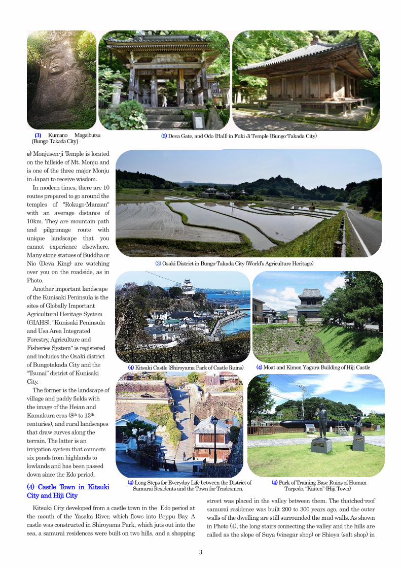
(3) Rokugo-manzan in Kunisaki Peninsula. As mentioned above, the mountainous area of the Kunisaki
Peninsula is a steep terrain with many radial valleys centered on
Mt. Futagoyama. Under these circumstances, Ninmon Bosatsu
(Bodhisattva) of legendary monk, established Mountain Buddhism
in 718, and from the end of the 11th century to early 12th century,
monks of the Tendai sect built mounds to bury sutras. As a result,
many temples were built in about 30 valleys and dispersed into six
sanctuaries, and they are collectively called “Rokugo-Manzan
(mountain in six sanctuaries) ”.
Ninmon Bosatsu is said to be the incarnation of Hachiman
Okami (God). Therefore, "Rokugo-Manzan" is a religion that
combines the Buddhist Tendai sect, and the Hachiman God
worship of Usa-jingu shrine at the root of the peninsular (See Q-❿).
There were up to 65 temples, but even today, there are still around
30 temples including Usa Shrine, all of which is the world of
Buddha surrounded by forests.
For reference, some temples can be introduced as follows:
a) The Usa-jingu shrine is the headquarters of Hachiman shrines.
b) Odo (Big Hall) of Fuki-ji Temple is the oldest wooden building in
Kyushu, National treasure, and was built in the 8th century.
c) Choan-Ji Temple supervised many temples during the
Kamakura period (around the 12th to 13th C).
d) Futago-Ji Temple was the best praying place for the Kitsuki clan
during the Edo period.
(1) Usa-Jingu (Usa City)
(1) Town in Showa Era (Bungotakada City)
(2) Cape of Nagasaki Bana
(3) Okunoin of Futagoji-temple Stone Buddha on the Roadside Statue of Nio
Fox Dance in Hime-Shima Island.
3
e) Monjusen-ji Temple is located
on the hillside of Mt. Monju and
is one of the three major Monju
in Japan to receive wisdom.
In modern times, there are 10
routes prepared to go around the
temples of "Rokugo-Manzan"
with an average distance of
10km. They are mountain path
and pilgrimage route with
unique landscape that you
cannot experience elsewhere.
Many stone statues of Buddha or
Nio (Deva King) are watching
over you on the roadside, as in
Photo.
Another important landscape
of the Kunisaki Peninsula is the
sites of Globally Important
Agricultural Heritage System
(GIAHS). "Kunisaki Peninsula
and Usa Area Integrated
Forestry, Agriculture and
Fisheries System" is registered
and includes the Osaki district
of Bungotakada City and the
“Tsunai” district of Kunisaki
City.
The former is the landscape of
village and paddy fields with
the image of the Heian and
Kamakura eras (8th to 13th
centuries), and rural landscapes
that draw curves along the
terrain. The latter is an
irrigation system that connects
six ponds from highlands to
lowlands and has been passed
down since the Edo period.
(4) Castle Town in Kitsuki
City and Hiji City
Kitsuki City developed from a castle town in the Edo period at
the mouth of the Yasaka River, which flows into Beppu Bay. A
castle was constructed in Shiroyama Park, which juts out into the
sea, a samurai residences were built on two hills, and a shopping
street was placed in the valley between them. The thatched-roof
samurai residence was built 200 to 300 years ago, and the outer
walls of the dwelling are still surrounded the mud walls. As shown
in Photo (4), the long stairs connecting the valley and the hills are
called as the slope of Suya (vinegar shop) or Shioya (salt shop) in
(3) Kumano Magaibutsu (Bungo Takada City)
(3) Deva Gate, and Odo (Hall) in Fuki Ji Temple (Bungo-Takada City)
(4) Long Steps for Everyday Life between the District of Samurai Residents and the Town for Tradesmen.
(4) Kitsuki Castle (Shiroyama Park of Castle Ruins)
(4) Park of Training Base Ruins of Human Torpedo, “Kaiten” (Hiji Town)
(4) Moat and Kimon Yagura Building of Hiji Castle
(3) Osaki District in Bungo-Takada City (World’s Agriculture Heritage)
4
accordance of the shops in
the valley. These are still
used on a daily basis, and
children are going up and
down the hill to school as
in the Edo period.
Hiji Town is on the west
of the Kitsuki City. In the
Edo period, it was the
territory of Kinoshita
clan, a relative of
Hideyoshi Toyotomi, and
the castle was built on the
coastal terrace facing
Beppu Bay. The ruins of
castle are now an
elementary school, but
facilities such as moats,
stone walls, Yagura
(watchtower), and the
slope that allow ships to
enter and leave the sea,
are remained.
In addition, fresh water
springs from the seabed
near the coast under Hiji
Castle, which is a
brackish water area with
low salinity. For the reason, Marbled flounder grows in seawater
and freshwater plankton and is called castle flounder, and its
taste is light and elegant.
(5) Spa Town of Beppu City (See Q-❽)
Beppu City is famous for having the largest number of hot springs
in Japan, which is 2,300. According to your physical condition and
preference, you can enjoy eight types of hot springs. Of course, there
are also hells that spouts various hot water from the deep part of
the earth, and you can hear the beat of the earth.
In addition, if you follow National Road 10 from Beppu City to
Oita City, you will find an aquarium and an artificial beach along
the road. Takasaki Nature Zoo for a wild monkey, is also famous.
Beppu City is a resort town with plenty of hot springs, hells, and
recreational facilities.
(6) CBD Zone in Oita City.
Sorin Otomo (1530-1587) was the lord of the Oita region during
the Warring States period, which ruled a large area in northern
Kyushu. He was a Christian and invited Xavier (Spanish monk)
and others. For these reasons, he is the most familiar person to the
citizens of Oita and is proud of him (see Photo (6)).
On the other hand, if you head toward the center of Oita City on
National Road 171, you will find the Funai-jo castle on the right
side of the road. This place was originally a place for loading and
unloading cargo. Construction of the castle began in 1597 and was
finally completed after the new daimyo took office in 1602,
following the Battle of Sekigahara. But currently, only parts such
as the castle gate, stone walls, and moats remain.
(7)Saganoseki District in Oita City
The Saganoseki Peninsula, located at the western end of Oita City,
is famous for mackerel and horse mackerel fishing. The lighthouse
is at the tip of the peninsula, from which the direction of National
Road 197 turns along Usuki Bay, where you can enjoy two different
beaches, one with: black serpentine and the other with white sand.
If the weather is good, you can also see Shikoku Main Island from
the observatory deck of Sekizaki-kaiseikan, an observatory and
observation facility.
(5) Ponds of Blood Hell and Yama Hell, where water vapor is blowing up
from near the mountain skirt.
(6) Statue of Otomo Sorin in Oita
Station Square.
(5)Beppu Spa Town (Beppu City)
(6) Funai Castle fortified in 1597
(7) Saganoseki Fishing Port
Publishing and Copy right: Promotion Council of Scenic Byway Kyushu ○C Copy right 2021. All rights reserved)