118
TRENTON COMPREHENSIVE PLAN June 2006
TRENTON COMPREHENSIVE
PLAN
June 2006
TRENTON
COMPREHENSIVE PLAN 2006
Prepared by the Trenton Comprehensive Planning Committee:
Fred Ehrlenbach, Chair Duane Bartlett
James Cameron Peter Dow
Vincent Esposito Michael Hodgkins
Peter Lazas Fred Noyes
Mark Remick Michael Swanson
Gary Weber Dorothy Young
With technical assistance from the
Hancock County Planning Commission
PART I:
INVENTORY AND ANALYSIS
June 2006
TABLE OF CONTENTS
SECTION PAGE INTRODUCTION........................................................................................................1 PART I INVENTORY AND ANALYSIS A. Population.............................................................................................................2
1. Purpose .......................................................................................................2 2. Key Findings and Issues .............................................................................2 3. Highlights of the 1992 Plan..........................................................................2 4. Trends Since 1990 ......................................................................................2 5. Seasonal Population....................................................................................4 6. Projected Population ...................................................................................5
B. Economy...............................................................................................................6 1. Purpose .......................................................................................................6 2. Key Findings and Issues .............................................................................6 3. Highlights of the 1992 Plan..........................................................................6 4. Trends since 1990 .......................................................................................6 5. Current Economic Issues...........................................................................11
C. Housing ..............................................................................................................12 1. Purpose .....................................................................................................12 2. Key Findings and Issues ...........................................................................12 3. Summary of the 1992 Plan ........................................................................12 4. Trends since 1990 .....................................................................................12 5. Affordable Housing ....................................................................................16 6. Major Housing Issues ................................................................................17 7. Dwelling Unit Projections...........................................................................17
D. Transportation ....................................................................................................19 1. Purpose .....................................................................................................19 2. Key Findings and Issues ...........................................................................19 3. Highlights of the 1992 Plan........................................................................19 4. State, Municipal and Private Road System................................................19
a. Road Mileage and Classification.....................................................19 b. Traffic Flow .....................................................................................20 c. High Crash Location........................................................................21
5. Railways ....................................................................................................24 6. Airports ......................................................................................................24 7. Adequacy of Existing Measures to Manage Traffic Impacts of Dev...........24 8. Public Transportation.................................................................................25
9. Local Parking Facilities, Bicycles and Sidewalks ......................................25 10. Regional Issues.........................................................................................25 11. Future Needs .............................................................................................26
E. Public Facilities and Services .............................................................................27 1. Purpose .....................................................................................................27 2. Key Findings and Issues ...........................................................................27 3. Summary of 1992 Plan ..............................................................................27 4. Town Government .....................................................................................27
a. Current Condition............................................................................27 b. Current and Future Adequacy.........................................................28
5. Solid Waste Disposal and Recycling .........................................................28 a. Current Condition............................................................................28 b. Current and Future Adequacy.........................................................28
6. Fire Protection ...........................................................................................28 a. Current Condition............................................................................28 b. Current and Future Adequacy.........................................................30
7. Police Protection........................................................................................30 a. Current Condition............................................................................30 b. Current and Future Adequacy.........................................................31
8. Ambulance.................................................................................................31 9. Education...................................................................................................31 a. Current Condition ...........................................................................31
10. Public Works ..............................................................................................34 F. Recreation...........................................................................................................35
1. Purpose .....................................................................................................35 2. Key Findings and Issues ...........................................................................35 3. Summary of the 1992 Plan ........................................................................35 4. Recreation Sites and Programs.................................................................35 5. State Recreation Standards & Comparisons to Other Towns....................36 6. Open Space...............................................................................................38 7. Scenic Resources......................................................................................38 8. Current & Future Adequacy of Recreation, Scenic & Open Space Res ....38
G. Marine Resources ..............................................................................................39 1. Purpose .....................................................................................................39 2. Key Findings and Issues ...........................................................................39 3. A Summary of the 1992 Plan.....................................................................39 4. An Overview of Trenton’s Marine Resources ............................................39 5. Marine Water Quality.................................................................................40 6. Commercial Fishing...................................................................................40 7. Related Marine Employment ....................................................................42 8. Water Dependent Uses .............................................................................42 9. Adequacy of Existing Ordinances and Protective Measures .....................42
10. Public Access Points ..................................................................................42 H. Water Resources ................................................................................................43
1. Purpose .....................................................................................................43 2. Key Findings and Issues ...........................................................................43 3. Summary of the 1992 Plan ........................................................................43 4. Ponds and Watersheds .............................................................................43 5. Freshwater Wetlands.................................................................................44
6. Rivers and Streams ...................................................................................44 7. Coastal Wetlands ......................................................................................44 8. Flood Hazard Areas...................................................................................45 9. Ground Water ............................................................................................45
10. Public Water Systems ................................................................................45 11. Existing and Potential Threats....................................................................47 12. Regional Considerations ............................................................................47 13. Adequacy of Existing Protection Measures ................................................47
I. Natural Resources................................................................................................48 1. Purpose .....................................................................................................48 2. Key Findings and Issues ...........................................................................48 3. Summary of the 1992 Plan ........................................................................48 4. Areas Identified by Maine’s Beginning with Habitat Program ....................48 5. Other Natural Features..............................................................................49 6. Fresh Water Fisheries ...............................................................................50 7. Threats and Existing Protection.................................................................50
J. Agricultural and Forest Resources ......................................................................51 1. Purpose .....................................................................................................51 2. Key Findings and Issues ...........................................................................51 3. Highlights of the 1992 Plan........................................................................51 4. Agricultural Resources ..............................................................................51 5. Forest Resources ......................................................................................52 6. An Analysis of Threats to Farm & Forest Land from Projected Dev. .........54 7. Adequacy of Existing Measures to Protect Farm and Forest Land............54
K. Historic and Archaeological Resources ..............................................................55 1. Purpose .....................................................................................................55 2. Key Findings and Issues ...........................................................................55 3. Summary of the 1992 Plan ........................................................................55 4. Town History..............................................................................................55 5. Identified, Pre-Historic, Historic, and Archaeological Sites ........................58 6. Adequacy of Existing Protection Efforts.....................................................59 7. Threats and Planning Implications.............................................................59
L. Land Use.............................................................................................................60 1. Purpose .....................................................................................................60 2. Key Findings and Issues ...........................................................................60 3. Summary of the 1992 Plan ........................................................................60 4. Overview....................................................................................................60 5. Existing Zoning and Regulations ...............................................................62 6. Land Use Issues........................................................................................63
7. Land Needed for Future Development ......................................................63 8. Regional Implications ................................................................................64
M. Fiscal Capacity ...................................................................................................65 1. Purpose .....................................................................................................65 2. Key Findings and Issues ...........................................................................65 3. Summary of the 1992 Plan ........................................................................65 4. Valuation and Tax Assessment .................................................................65
5. Tax Base and Revenue Sources ...............................................................67 6. Municipal Expenditure Trends. ..................................................................69
7. The Future.................................................................................................70 N. Inventory and Analysis Summary .......................................................................71
1. Purpose .....................................................................................................71 2. Priority Issues ............................................................................................71 3. Key Findings and Issues ...........................................................................71
a. Population......................................................................................71 b. Economy........................................................................................71 c. Housing..........................................................................................72 d. Transportation................................................................................72 e. Public Facilities and Services ........................................................72 f. Recreation .....................................................................................72 g. Marine Resources..........................................................................72 h. Water Resources ...........................................................................73 i. Natural Resources .........................................................................73 j. Agricultural and Forest Resources.................................................73 k. Historical and Archaeological Resources.......................................73 l. Existing Land Use ..........................................................................73 m. Fiscal Capacity ..............................................................................73
4. Key Regional Issues..................................................................................74
PART II GOALS AND OBJECTIVES
1. Purpose .....................................................................................................76 2. Overall Goal...............................................................................................76 3. Goals and Objectives ................................................................................76
A. Population Goal ...................................................................................................76 B. Economy.............................................................................................................76
1. Regional Coordination ...............................................................................77 2. Assistance to Existing Businesses ............................................................77 3. Home Based Occupations.........................................................................77 4. Business Park Expansion..........................................................................77 5. Village Business Development ..................................................................77
C. Housing ..............................................................................................................78 1. First Time Homebuyer Subdivision............................................................78 2. Improvement of Existing Housing Stock ....................................................78 3. Land Use Ordinance Standards ................................................................79 4. Senior Citizen Housing ..............................................................................79 5. Regional Housing Ventures.......................................................................79
D. Transportation ....................................................................................................79 1. Route 3 Corridor Improvements ................................................................80 2. Access Management .................................................................................81 3. Sight Distance ...........................................................................................81 4. Scenic Byway ............................................................................................82 5. Pedestrian Facilities ..................................................................................82
6. Bicycle Facilities ........................................................................................83 7. Town Road Policy......................................................................................83 8. Parking ......................................................................................................83
9. Separation of Local and Through Traffic ...................................................84 10. Managing Off-site Traffic Impacts of Development ...................................84
E. Public Facilities and Services .............................................................................85 1. Police Protection........................................................................................85 2. Education...................................................................................................85 3. Public Works..............................................................................................85 4. Fire Protection and Emergency Response ................................................86 5. Municipal Government and Buildings ........................................................86 6. Solid Waste and Recycling ........................................................................86 7. Ambulance Service....................................................................................87
F. Recreation, Open Space and Scenic Resources ...............................................87 1. Current Recreation Arrangements.............................................................87 2. Open Space Preservation .........................................................................87 3. Scenic Resources......................................................................................88
G. Marine Resources ..............................................................................................88 1. Public Access ............................................................................................88 2. Marine Water Quality.................................................................................88 3. Shellfish Restoration..................................................................................88
H. Water Resources ................................................................................................89 1. Ground Water Protection...........................................................................89 2. Non-Point Source Management and Stormwater Runoff...........................89 3. Floodplain Management ............................................................................90 4. Wetlands Protection ..................................................................................90 5. Public Water System Protection ................................................................90
I. Historic and Archaeological Resources Goals ....................................................91 J. Natural Resources...............................................................................................92 K. Agricultural and Forest Resources Goal .............................................................92 L. Land Use.............................................................................................................93
1. Managing Commercial Strip Development ................................................93 2. Promoting Village Development ................................................................93
3. Airport Coordination...................................................................................94 4. Rural Area Protection and Natural Resource Conservation ......................94
5. Contract Zoning.........................................................................................94 M. Fiscal Capacity ...................................................................................................95
1. Alternative Funding Sources......................................................................95 2. Fiscal Planning ..........................................................................................95 3. Impact Fees...............................................................................................96
N. Capital Investment Plan......................................................................................96 O. Regional Coordination ........................................................................................98
PART III FUTURE LAND USE
1. Introduction..............................................................................................102 2. Land Needed for Future Development ....................................................102 3. Criteria for Growth and Rural Areas ........................................................103
a. Soils .............................................................................................103 b. Roads and Infrastructure .............................................................103 c. Existing Built up Areas .................................................................103 d. Areas with Development Constraints & Key Natural Resources..104 e. Conclusions .................................................................................104
4. A Future Land Use Scheme for Trenton.................................................104 a. An Overview ................................................................................104 b. The Village Area ..........................................................................105 c. Manufacturing Areas ....................................................................106 d. Commercial Areas .......................................................................106 e. Residential Growth Area ..............................................................106 f. Residential Areas.........................................................................107
5. Measures to Distinguish Between Growth and Rural Areas ...................107 6. Benchmark Measurements.....................................................................107 7. Conclusions ............................................................................................108
TABLES AND MAPS Tables: Part I A.1 Historical Population Trends ..........................................................................3 A.2 Change in Age Breakdown.............................................................................3 A.3 Projected Population ......................................................................................5 B.1 Class of Workers............................................................................................7 B.2 Employment by Industry Sector, 2000 ...........................................................8 B.3 Average Annual Unemployment Rate 1999-2003 ..........................................9 B.4 Town Businesses ...........................................................................................9 C.1 Change in Housing Units: 1990-2000 ..........................................................13 C.2 Change in Housing Types: 1990-2000.........................................................13 C.3 Estimated Tenure of Occupied Year-Round Housing: 1990 & 2000 ............14 C.4 Contract Rent of Renter-Occupied Units Trenton/Hancock County 2000 ....15 C.5 Value of Specified Owner-Occupied Housing Units 2000 ............................16 C.6 Projected Year Round Occupied Dwelling Units ..........................................18 D.1 Average Annual Daily Traffic........................................................................20 D.2 MaineDOT Crash Data 2001-2003 Rt. 3 Intersections.................................21 D.3 MaineDOT Crash Data for 2001-2003 Rt. 3 Segments................................22 E.1 Fire Department Service Calls .....................................................................29 E.2 Fire Department Vehicles.............................................................................30 E.3 School Enrollment Trends ............................................................................32 E.4 School Enrollment Projections .....................................................................33
F.1 State Guidelines for Standards & Comparison to Other Towns ...................36 G.1 Clam Harvest by Town.................................................................................41 G.2 Trenton Resident Fishing Licenses by Select Category...............................41 H.1 Public Water Systems ..................................................................................46 J.1 Farm and Open Space Parcels ....................................................................52 J.2 Tree Growth Parcels ....................................................................................53 J.3 Timber Harvesting Trends 1996-2002..........................................................53 L.1 Summary of Commercial, Manufacturing & Multi-Family Development .......61 L.2 Summary of Subdivision Activity ..................................................................61 L.3 Soil Suitability for Low Density Urban Development ....................................62 M.1 Trends in Valuation 1993-2004 ....................................................................66 M.2 Trends in Tax Commitment 1993-2004........................................................66 M.3 Summary of Municipal Valuation by Type 2004 ...........................................67 M.4 Revenue Sources.........................................................................................68 M.5 State School Subsidies ................................................................................68 M.6 Summary of Appropriations..........................................................................69 M.7 Comparison of Appropriations 1993-2004....................................................70
Part II II.1 Summary of Anticipated Capital Expenditures 2007-2013......................... 97 Maps 1. Base Map 2. Land Use and Ownership 2A. Land Use and Ownership Types 3. Water and Marine Resources 3B. Natural Resources 4. Cultural Resources 5. Proposed Future Land Use 6. Existing Zoning 7. Soils
Page 1
INTRODUCTION The Trenton comprehensive plan is an advisory document. It reflects the desired future of the town. Overall, it identifies current issues and opportunities that the town faces and discusses what is expected to happen within the next five to ten years. It is an update to the 1992 plan and replaces that document. The plan consists of two major parts. The Inventory and Analysis discusses recent trends in the town and projects what may happen in the future. While it discusses some options for the town to consider, these are not recommendations. Rather, this section is a reference document that reflects conditions in the town as of early-2006. Since all towns change rapidly, some of the information in this section may be out of date by the time the plan is adopted. The second part is the Goals, Policies, Implementation Strategies and Future Land use Plan. This section sets specific recommendations for the future of the town. These recommendations are followed by detailed implementation strategies that indicate who will do what and when. The Future Land Use Plan presents a vision of how the town should grow.
The plan, however, is not valid until it is adopted by the voters. While the plan is the legal basis of any changes to land use ordinances, all such changes must be voted upon by the voters separate from the comprehensive plan vote. Public hearings are required before any vote. The plan is intended to guide the select board, planning board, town employees and other town committees and boards in their decisions and provide continuity in town policy. It can also be used to help Trenton seek funding from various state and federal grant programs. Residents are reminded that planning is an on-going process. This plan should be reviewed annually to see if its assumptions are still valid. A more thorough review may be needed in five years.
Page 2
A. POPULATION 1. Purpose Population is one of the most basic components of a comprehensive plan. In order to understand Trenton’s current and future needs, it is important to review population trends. This section aims to accomplish the following:
a. Review population trends since 1990; and b. Project future population growth.
2. Key Findings and Issues
Trenton is one of the fastest growing towns in Hancock County. Its year-round population increased by 29 percent between 1990 and 2000. The town’s 2015 population is projected to be 1,738, which is 26 percent more than its 2000 population of 1,374. The town’s residential population is estimated to more than double during the peak summer and this figure does not include the vast number of day visitors, nor the people who work in town. The town’s population is aging. Those in the 45-64 age group increased by 51 percent.
3. Highlights of the 1992 Plan
The plan noted that the there had been a considerable influx of young families with
school-aged children. It projected a year-round population for 2000 of 1,468 while the U.S. Census for that year reported a population of 1,370. There had been a decrease in the average household size.
4. Trends Since 1990
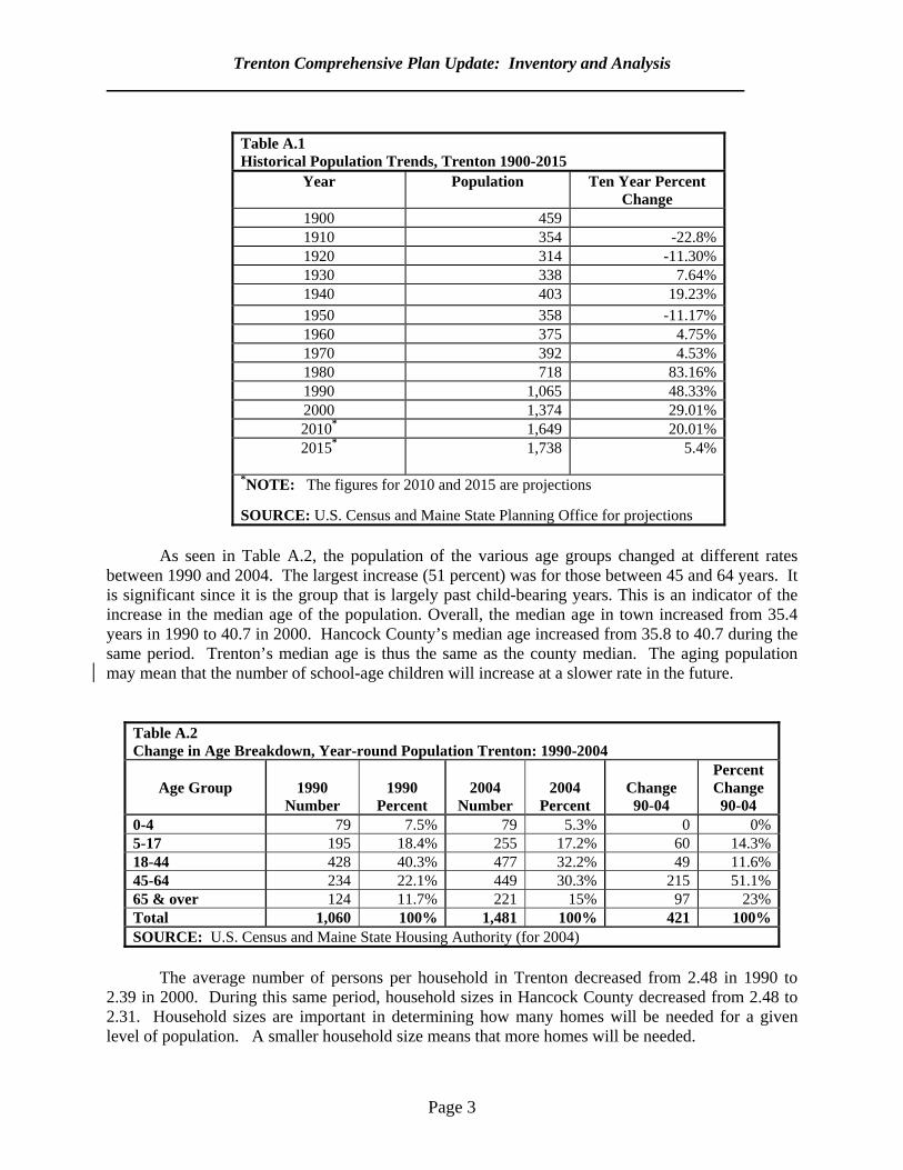
Table A.1 shows historical population trends for Trenton. After a period of population fluctuation for the first few decades of the 20th century, the town saw steady year-round population growth toward the end of the century. In fact, between 1990 and 2000, it was one of the fastest growing towns in Hancock County.
Trenton Comprehensive Plan Update: Inventory and Analysis
Page 3
Table A.1 Historical Population Trends, Trenton 1900-2015
Year Population Ten Year Percent Change
1900 459 1910 354 -22.8% 1920 314 -11.30% 1930 338 7.64% 1940 403 19.23% 1950 358 -11.17% 1960 375 4.75% 1970 392 4.53% 1980 718 83.16% 1990 1,065 48.33% 2000 1,374 29.01% 2010* 1,649 20.01% 2015* 1,738 5.4%
*NOTE: The figures for 2010 and 2015 are projections SOURCE: U.S. Census and Maine State Planning Office for projections
As seen in Table A.2, the population of the various age groups changed at different rates
between 1990 and 2004. The largest increase (51 percent) was for those between 45 and 64 years. It is significant since it is the group that is largely past child-bearing years. This is an indicator of the increase in the median age of the population. Overall, the median age in town increased from 35.4 years in 1990 to 40.7 in 2000. Hancock County’s median age increased from 35.8 to 40.7 during the same period. Trenton’s median age is thus the same as the county median. The aging population may mean that the number of school-age children will increase at a slower rate in the future.
Table A.2 Change in Age Breakdown, Year-round Population Trenton: 1990-2004
Age Group
1990
Number
1990
Percent
2004
Number
2004
Percent
Change 90-04
Percent Change 90-04
0-4 79 7.5% 79 5.3% 0 0%5-17 195 18.4% 255 17.2% 60 14.3%18-44 428 40.3% 477 32.2% 49 11.6%45-64 234 22.1% 449 30.3% 215 51.1%65 & over 124 11.7% 221 15% 97 23%Total 1,060 100% 1,481 100% 421 100%SOURCE: U.S. Census and Maine State Housing Authority (for 2004)
The average number of persons per household in Trenton decreased from 2.48 in 1990 to
2.39 in 2000. During this same period, household sizes in Hancock County decreased from 2.48 to 2.31. Household sizes are important in determining how many homes will be needed for a given level of population. A smaller household size means that more homes will be needed.
Trenton Comprehensive Plan Update: Inventory and Analysis
Page 4
There have been changes in other population statistics as well. In 1990 the town had a
median household income of $29,760, which was 118 percent of the county median income of $25,247. By 2000, Trenton’s median income had increased to $34,808, which was about 97 percent of the county income of $35,811. The town’s median income has not kept pace with that of the county. Similarly, the 1990 poverty rate in Trenton was 5.3 percent compared to 10.0 percent for Hancock County. By 2000, the town poverty rate had increased to 10.0 percent compared to 7.1 percent for the county. The town’s poverty rate had virtually doubled while the rate for the county as whole decreased.
There has been an increase in educational attainment levels. In 1990, 82.6 percent of Trenton
residents aged 25 and older had a high school education and 23.4 percent had a bachelor’s degree. By 2000, 89.2 percent had a high school degree and 30.6 percent had a bachelor’s degree. By comparison, Hancock County in 2000 had an 87.8 percent high school education rate and a 27.1 percent Bachelor of Arts degree rate. Educational attainment rates county-wide are somewhat lower than those in Trenton.
There are two basic components to Trenton’s year-round population: those residing in
households and those living in group quarters such as dormitories and nursing homes. In Trenton, the 2000 Census reported no one living in group quarters. 5. Seasonal Population It is very difficult to estimate a town’s seasonal population. There are several sources of population that affect a town’s seasonal fluctuations. First, there are people who reside in seasonal dwellings and their house guests. Second, there are people residing in transient accommodations such as campgrounds, bed and breakfasts and similar lodgings. Third, there are day visitors. A general estimate of the population residing in seasonal homes can be made by multiplying the total number of second homes by the average household size. While there is no way to estimate the average household size for a second home it can be argued that it is normally larger than that of year-round home since seasonal homes tend to have more visitors or to be used by families. Therefore, an average household size of 3.56 persons will be assumed for seasonal homes (compared to 2.39 for year-round homes). If the 3.56 persons per household is multiplied by the 219 second homes reported in the 2000
Census, there would be 785 persons residing in second homes. Thus the peak summer resident population is around 2,159. This figure combines the year-round population of 1,374 and 785 seasonal residents. The town’s population increases by about 57 percent in the peak summer months. It should be noted that this figure does not include the population in transient accommodations such as camp grounds, hotels and bed and breakfasts. An estimate by the comprehensive planning committee indicates that there are about 350 beds/camping places in seasonal accommodations in town or about 700 persons. This means that the town could have a peak summer resident population of 2,859, which is more than double the year-round population. The peak population consists of 2,159 persons in dwellings plus 700 persons in transient accommodations). Like any estimate, this should be seen as general.

Trenton Comprehensive Plan Update: Inventory and Analysis
Page 5
6. Projected Population
There is no reliable way to project population for a small town such as Trenton. Some general statistical models can be used, however. The State Planning Office (SPO) has developed year-round population projections for all towns in the state through 2015. The figures for Hancock County and Trenton are shown on Table A.3. As seen, Hancock County as a whole has considerable growth potential. This is consistent with recent trends of a high in-migration rate. Trenton is projected to grow at a 26 percent rate between 2000 and 2015.
Table A.3 Projected Population through 20151
Unit of Government 2000 2010 2015 Trenton 1,374 1,649 1,738 Hancock County 51,791 56,635 58,741
1 NOTE: refer to text for discussion of limitations of data SOURCE: State Planning Office web site

Page 6
B. ECONOMY 1. Purpose An understanding of the economy is important in planning for the future of a town. This section aims to accomplish the following:
a. Summarize recent economic trends; and b. Identify current economic issues.
2. Key Findings and Issues
Trenton’s labor force increased from 524 persons in 1990 to 708 in 2000. There are no major differences in employment patterns in Trenton and in the county as a whole. However, unemployment rates in town are generally below the county average. The town has attracted many new and expanded business. More people commute into Trenton than commute out of town.
3. Highlights of the 1992 Plan The plan reported that the economy in Trenton was largely seasonal and most residents of working age commuted out of town for employment. Results of a survey revealed that the business community would support a plan to improve the business climate along the Route 3 corridor.
4. Trends Since 1990
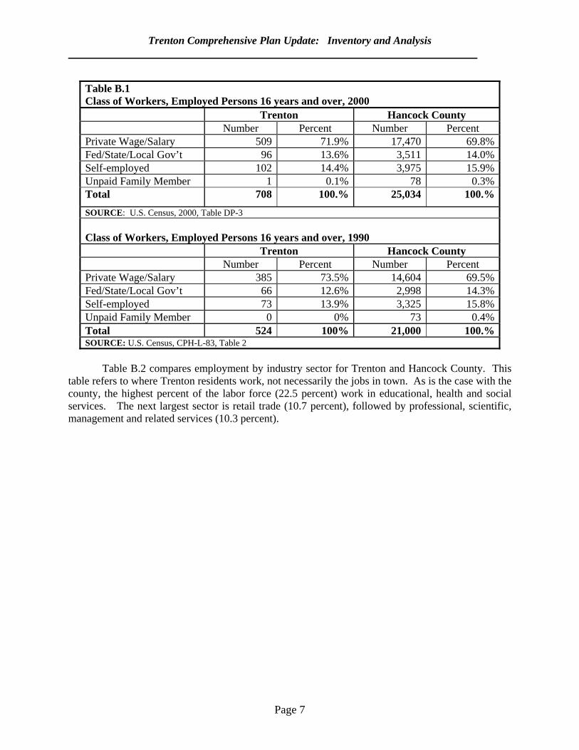
Table B.1 compares employment by classification between Trenton and Hancock County for
1990 and 2000. Overall, the size of the labor force increased from 524 in 1990 to 708 in 2000, an increase of 35 percent. There were only minor differences in the breakdown among the employment classifications. The proportions of people who were government workers, private workers and self-employed remained largely unchanged. There are just minor differences between the employment classification breakdown of the Trenton labor force and that of Hancock County in the year 2000. The town has a slightly smaller percentage of government workers and self-employed than does the county.
Trenton Comprehensive Plan Update: Inventory and Analysis
Page 7
Table B.1 Class of Workers, Employed Persons 16 years and over, 2000 Trenton Hancock County Number Percent Number Percent Private Wage/Salary 509 71.9% 17,470 69.8%Fed/State/Local Gov’t 96 13.6% 3,511 14.0%Self-employed 102 14.4% 3,975 15.9%Unpaid Family Member 1 0.1% 78 0.3%Total 708 100.% 25,034 100.%
SOURCE: U.S. Census, 2000, Table DP-3 Class of Workers, Employed Persons 16 years and over, 1990 Trenton Hancock County Number Percent Number Percent Private Wage/Salary 385 73.5% 14,604 69.5%Fed/State/Local Gov’t 66 12.6% 2,998 14.3%Self-employed 73 13.9% 3,325 15.8%Unpaid Family Member 0 0% 73 0.4%Total 524 100% 21,000 100.%SOURCE: U.S. Census, CPH-L-83, Table 2
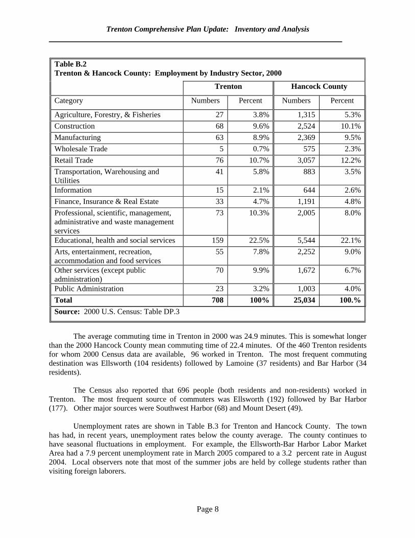
Table B.2 compares employment by industry sector for Trenton and Hancock County. This
table refers to where Trenton residents work, not necessarily the jobs in town. As is the case with the county, the highest percent of the labor force (22.5 percent) work in educational, health and social services. The next largest sector is retail trade (10.7 percent), followed by professional, scientific, management and related services (10.3 percent).
Trenton Comprehensive Plan Update: Inventory and Analysis
Page 8
Table B.2 Trenton & Hancock County: Employment by Industry Sector, 2000
Trenton Hancock County
Category Numbers Percent Numbers Percent
Agriculture, Forestry, & Fisheries 27 3.8% 1,315 5.3%Construction 68 9.6% 2,524 10.1%Manufacturing 63 8.9% 2,369 9.5%Wholesale Trade 5 0.7% 575 2.3%Retail Trade 76 10.7% 3,057 12.2%Transportation, Warehousing and Utilities
41 5.8% 883 3.5%
Information 15 2.1% 644 2.6%Finance, Insurance & Real Estate 33 4.7% 1,191 4.8%Professional, scientific, management, administrative and waste management services
73 10.3% 2,005 8.0%
Educational, health and social services 159 22.5% 5,544 22.1%Arts, entertainment, recreation, accommodation and food services
55 7.8% 2,252 9.0%
Other services (except public administration)
70 9.9% 1,672 6.7%
Public Administration 23 3.2% 1,003 4.0%Total 708 100% 25,034 100.%Source: 2000 U.S. Census: Table DP.3
The average commuting time in Trenton in 2000 was 24.9 minutes. This is somewhat longer
than the 2000 Hancock County mean commuting time of 22.4 minutes. Of the 460 Trenton residents for whom 2000 Census data are available, 96 worked in Trenton. The most frequent commuting destination was Ellsworth (104 residents) followed by Lamoine (37 residents) and Bar Harbor (34 residents).
The Census also reported that 696 people (both residents and non-residents) worked in
Trenton. The most frequent source of commuters was Ellsworth (192) followed by Bar Harbor (177). Other major sources were Southwest Harbor (68) and Mount Desert (49).
Unemployment rates are shown in Table B.3 for Trenton and Hancock County. The town
has had, in recent years, unemployment rates below the county average. The county continues to have seasonal fluctuations in employment. For example, the Ellsworth-Bar Harbor Labor Market Area had a 7.9 percent unemployment rate in March 2005 compared to a 3.2 percent rate in August 2004. Local observers note that most of the summer jobs are held by college students rather than visiting foreign laborers.
Trenton Comprehensive Plan Update: Inventory and Analysis
Page 9
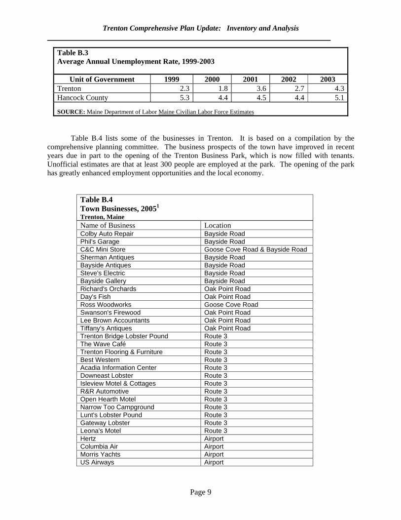
Table B.3 Average Annual Unemployment Rate, 1999-2003
Unit of Government 1999 2000 2001 2002 2003 Trenton 2.3 1.8 3.6 2.7 4.3Hancock County 5.3 4.4 4.5 4.4 5.1 SOURCE: Maine Department of Labor Maine Civilian Labor Force Estimates
Table B.4 lists some of the businesses in Trenton. It is based on a compilation by the comprehensive planning committee. The business prospects of the town have improved in recent years due in part to the opening of the Trenton Business Park, which is now filled with tenants. Unofficial estimates are that at least 300 people are employed at the park. The opening of the park has greatly enhanced employment opportunities and the local economy.
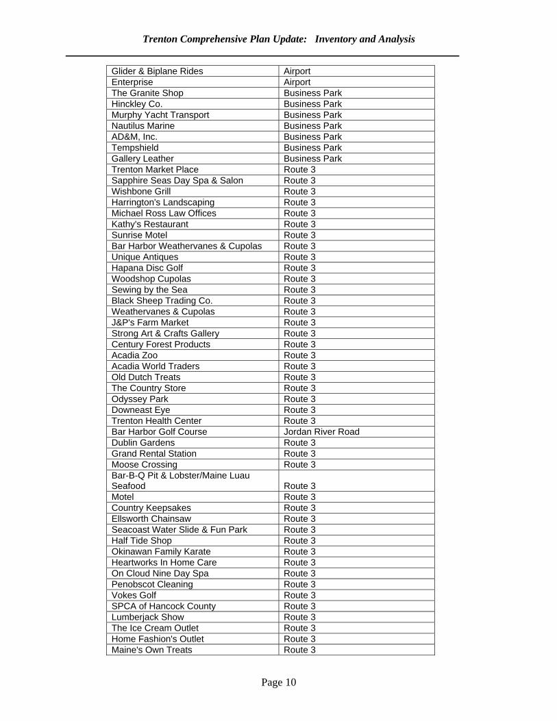
Table B.4 Town Businesses, 20051
Trenton, Maine Name of Business Location Colby Auto Repair Bayside Road Phil's Garage Bayside Road C&C Mini Store Goose Cove Road & Bayside Road Sherman Antiques Bayside Road Bayside Antiques Bayside Road Steve's Electric Bayside Road Bayside Gallery Bayside Road Richard's Orchards Oak Point Road Day's Fish Oak Point Road Ross Woodworks Goose Cove Road Swanson's Firewood Oak Point Road Lee Brown Accountants Oak Point Road Tiffany's Antiques Oak Point Road Trenton Bridge Lobster Pound Route 3 The Wave Café Route 3 Trenton Flooring & Furniture Route 3 Best Western Route 3 Acadia Information Center Route 3 Downeast Lobster Route 3 Isleview Motel & Cottages Route 3 R&R Automotive Route 3 Open Hearth Motel Route 3 Narrow Too Campground Route 3 Lunt's Lobster Pound Route 3 Gateway Lobster Route 3 Leona's Motel Route 3 Hertz Airport Columbia Air Airport Morris Yachts Airport US Airways Airport
Trenton Comprehensive Plan Update: Inventory and Analysis
Page 10
Glider & Biplane Rides Airport Enterprise Airport The Granite Shop Business Park Hinckley Co. Business Park Murphy Yacht Transport Business Park Nautilus Marine Business Park AD&M, Inc. Business Park Tempshield Business Park Gallery Leather Business Park Trenton Market Place Route 3 Sapphire Seas Day Spa & Salon Route 3 Wishbone Grill Route 3 Harrington's Landscaping Route 3 Michael Ross Law Offices Route 3 Kathy's Restaurant Route 3 Sunrise Motel Route 3 Bar Harbor Weathervanes & Cupolas Route 3 Unique Antiques Route 3 Hapana Disc Golf Route 3 Woodshop Cupolas Route 3 Sewing by the Sea Route 3 Black Sheep Trading Co. Route 3 Weathervanes & Cupolas Route 3 J&P's Farm Market Route 3 Strong Art & Crafts Gallery Route 3 Century Forest Products Route 3 Acadia Zoo Route 3 Acadia World Traders Route 3 Old Dutch Treats Route 3 The Country Store Route 3 Odyssey Park Route 3 Downeast Eye Route 3 Trenton Health Center Route 3 Bar Harbor Golf Course Jordan River Road Dublin Gardens Route 3 Grand Rental Station Route 3 Moose Crossing Route 3 Bar-B-Q Pit & Lobster/Maine Luau Seafood Route 3 Motel Route 3 Country Keepsakes Route 3 Ellsworth Chainsaw Route 3 Seacoast Water Slide & Fun Park Route 3 Half Tide Shop Route 3 Okinawan Family Karate Route 3 Heartworks In Home Care Route 3 On Cloud Nine Day Spa Route 3 Penobscot Cleaning Route 3 Vokes Golf Route 3 SPCA of Hancock County Route 3 Lumberjack Show Route 3 The Ice Cream Outlet Route 3 Home Fashion's Outlet Route 3 Maine's Own Treats Route 3
Trenton Comprehensive Plan Update: Inventory and Analysis
Page 11
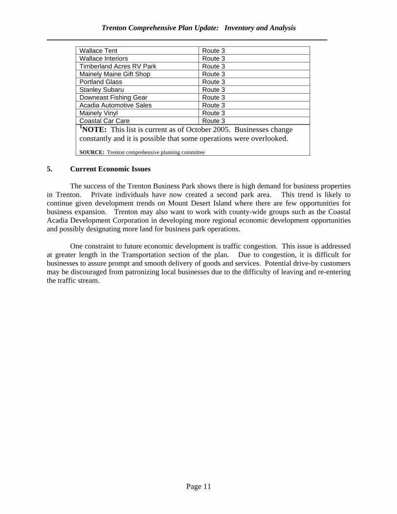
Wallace Tent Route 3 Wallace Interiors Route 3 Timberland Acres RV Park Route 3 Mainely Maine Gift Shop Route 3 Portland Glass Route 3 Stanley Subaru Route 3 Downeast Fishing Gear Route 3 Acadia Automotive Sales Route 3 Mainely Vinyl Route 3 Coastal Car Care Route 31NOTE: This list is current as of October 2005. Businesses change constantly and it is possible that some operations were overlooked. SOURCE: Trenton comprehensive planning committee
5. Current Economic Issues The success of the Trenton Business Park shows there is high demand for business properties in Trenton. Private individuals have now created a second park area. This trend is likely to continue given development trends on Mount Desert Island where there are few opportunities for business expansion. Trenton may also want to work with county-wide groups such as the Coastal Acadia Development Corporation in developing more regional economic development opportunities and possibly designating more land for business park operations. One constraint to future economic development is traffic congestion. This issue is addressed at greater length in the Transportation section of the plan. Due to congestion, it is difficult for businesses to assure prompt and smooth delivery of goods and services. Potential drive-by customers may be discouraged from patronizing local businesses due to the difficulty of leaving and re-entering the traffic stream.
Page 12
C. HOUSING
1. Purpose It is important for a comprehensive plan to have an analysis of the housing market and local and regional housing needs. This section aims to: a.. review housing trends since 1990; b. discuss housing affordability; c. identify major housing issues; and
d. project future housing construction trends.
2. Key Findings and Issues
The total number of dwelling units in Trenton increased by 22 percent between 1990
and 2000. The number of rental units increased by almost double the rate for Hancock County as a whole. While median household incomes in Trenton increased by 9.4 percent between 2001 and 2004, the median sales price of a house increased by 45 percent during the same period. The number of year-round, occupied units is projected to increase by 26 percent between 2000 and 2015,
3. Summary of the 1992 Plan
Trenton’s housing stock was described as newer and in better condition than in many parts of Hancock County. While there were housing opportunities for those of low and moderate income, there were not opportunities for those of very low income. Unlike in previous decades, the 1980s saw a much faster increase in year-round versus seasonal dwellings. The former increased at a 58 percent rate compared for a 9 percent rate for the latter.
4. Trends Since 1990
There was a nearly 22 percent increase in the total number of dwelling units (year-
round and seasonal) in Trenton between 1990 and 2000 (see Table C.1). As of 2000, there were 816 dwelling units in Trenton reported by the U.S. Census. The number of year-round units increased by nearly 28 percent (129 units) between 1990 and 2000. There was an 8 percent increase (17 units) in the number of second homes. As of 2000, 27 percent of the homes in town were seasonally occupied and 73 percent were year-round. In 1990 about 30 percent of the homes were seasonal and 70 percent were year-round. Local observers note that there have been many conversions of second homes to year-round use.
Trenton Comprehensive Plan Update: Inventory and Analysis
Page 13
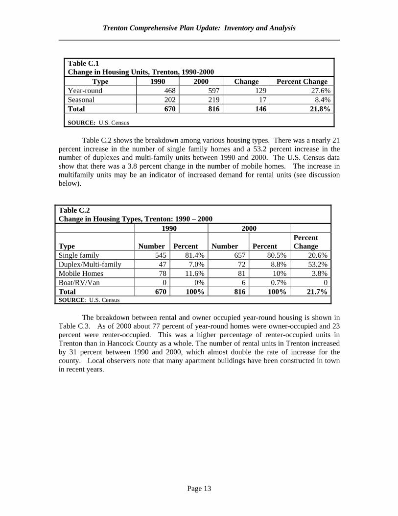
Table C.1 Change in Housing Units, Trenton, 1990-2000
Type 1990 2000 Change Percent Change Year-round 468 597 129 27.6%Seasonal 202 219 17 8.4%Total 670 816 146 21.8% SOURCE: U.S. Census
Table C.2 shows the breakdown among various housing types. There was a nearly 21
percent increase in the number of single family homes and a 53.2 percent increase in the number of duplexes and multi-family units between 1990 and 2000. The U.S. Census data show that there was a 3.8 percent change in the number of mobile homes. The increase in multifamily units may be an indicator of increased demand for rental units (see discussion below). Table C.2 Change in Housing Types, Trenton: 1990 – 2000
1990 2000 Type
Number
Percent
Number
Percent
Percent Change
Single family 545 81.4% 657 80.5% 20.6%Duplex/Multi-family 47 7.0% 72 8.8% 53.2%Mobile Homes 78 11.6% 81 10% 3.8%Boat/RV/Van 0 0% 6 0.7% 0Total 670 100% 816 100% 21.7%SOURCE: U.S. Census
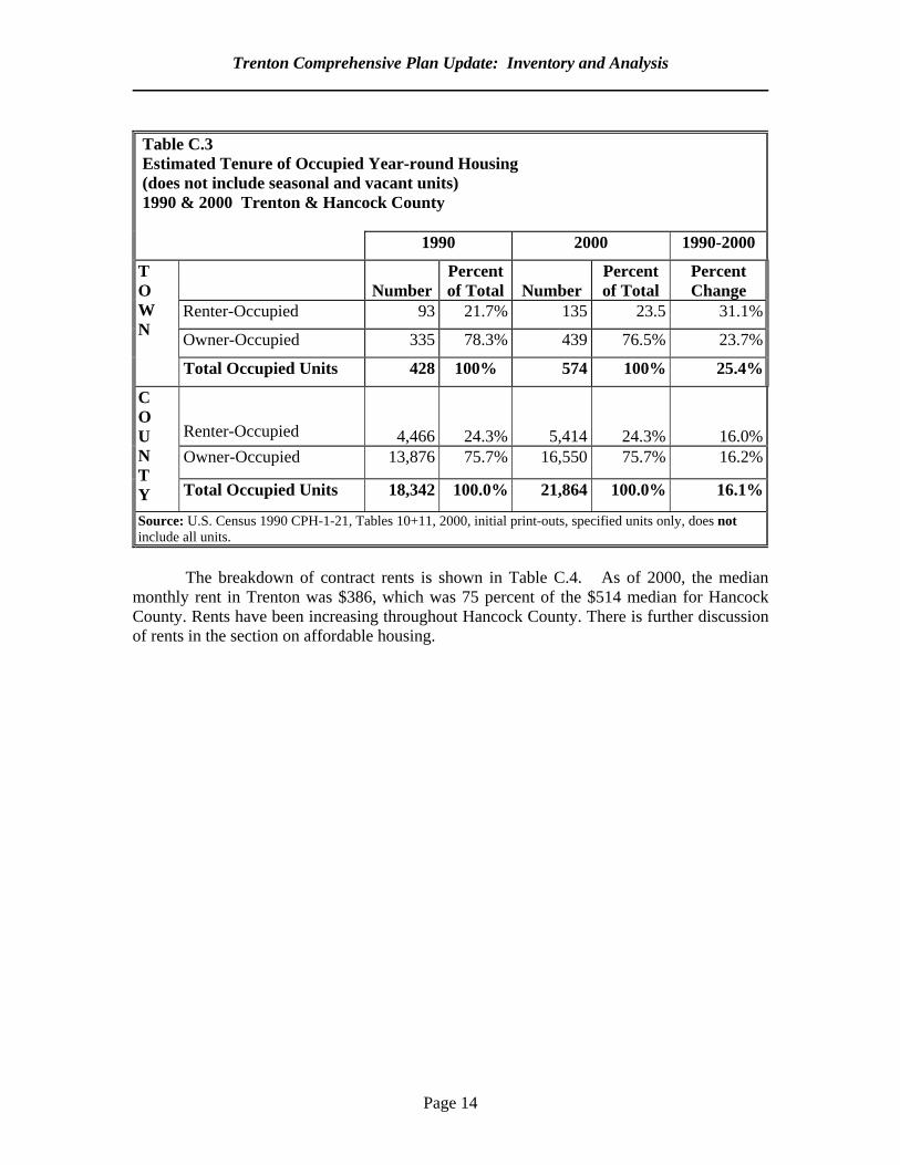
The breakdown between rental and owner occupied year-round housing is shown in
Table C.3. As of 2000 about 77 percent of year-round homes were owner-occupied and 23 percent were renter-occupied. This was a higher percentage of renter-occupied units in Trenton than in Hancock County as a whole. The number of rental units in Trenton increased by 31 percent between 1990 and 2000, which almost double the rate of increase for the county. Local observers note that many apartment buildings have been constructed in town in recent years.
Trenton Comprehensive Plan Update: Inventory and Analysis
Page 14
Table C.3 Estimated Tenure of Occupied Year-round Housing (does not include seasonal and vacant units) 1990 & 2000 Trenton & Hancock County 1990 2000 1990-2000
Number
Percent of Total
Number
Percent of Total
Percent Change
Renter-Occupied 93 21.7% 135 23.5 31.1%
T O W N Owner-Occupied 335 78.3% 439 76.5% 23.7%
Total Occupied Units 428 100% 574 100% 25.4%
Renter-Occupied 4,466 24.3% 5,414
24.3% 16.0%Owner-Occupied 13,876 75.7% 16,550 75.7% 16.2%
C O U N T Y Total Occupied Units 18,342 100.0% 21,864 100.0% 16.1%
Source: U.S. Census 1990 CPH-1-21, Tables 10+11, 2000, initial print-outs, specified units only, does not include all units.
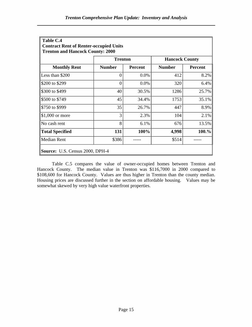
The breakdown of contract rents is shown in Table C.4. As of 2000, the median
monthly rent in Trenton was $386, which was 75 percent of the $514 median for Hancock County. Rents have been increasing throughout Hancock County. There is further discussion of rents in the section on affordable housing.
Trenton Comprehensive Plan Update: Inventory and Analysis
Page 15
Table C.4 Contract Rent of Renter-occupied Units Trenton and Hancock County: 2000
Trenton Hancock County
Monthly Rent Number Percent Number Percent
Less than $200 0 0.0% 412 8.2%
$200 to $299 0 0.0% 320 6.4%
$300 to $499 40 30.5% 1286 25.7%
$500 to $749 45 34.4% 1753 35.1%
$750 to $999 35 26.7% 447 8.9%
$1,000 or more 3 2.3% 104 2.1%
No cash rent 8 6.1% 676 13.5%
Total Specified 131 100% 4,998 100.%
Median Rent $386 ----- $514 ----- Source: U.S. Census 2000, DPH-4
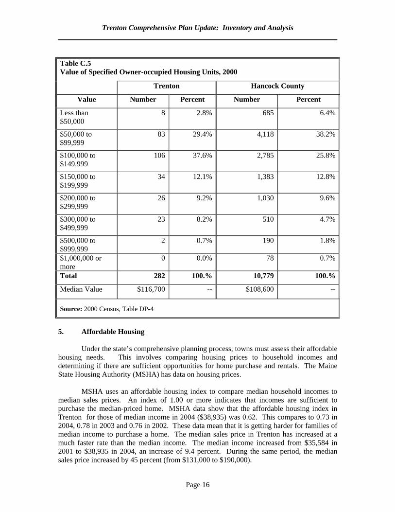
Table C.5 compares the value of owner-occupied homes between Trenton and
Hancock County. The median value in Trenton was $116,7000 in 2000 compared to $108,600 for Hancock County. Values are thus higher in Trenton than the county median. Housing prices are discussed further in the section on affordable housing. Values may be somewhat skewed by very high value waterfront properties.
Trenton Comprehensive Plan Update: Inventory and Analysis
Page 16
Table C.5 Value of Specified Owner-occupied Housing Units, 2000
Trenton Hancock County
Value Number Percent Number Percent
Less than $50,000
8 2.8% 685 6.4%
$50,000 to $99,999
83 29.4% 4,118 38.2%
$100,000 to $149,999
106 37.6% 2,785 25.8%
$150,000 to $199,999
34 12.1% 1,383 12.8%
$200,000 to $299,999
26 9.2% 1,030 9.6%
$300,000 to $499,999
23 8.2% 510 4.7%
$500,000 to $999,999
2 0.7% 190 1.8%
$1,000,000 or more
0 0.0% 78 0.7%
Total 282 100.% 10,779 100.%
Median Value $116,700 -- $108,600 -- Source: 2000 Census, Table DP-4
5. Affordable Housing
Under the state’s comprehensive planning process, towns must assess their affordable housing needs. This involves comparing housing prices to household incomes and determining if there are sufficient opportunities for home purchase and rentals. The Maine State Housing Authority (MSHA) has data on housing prices.
MSHA uses an affordable housing index to compare median household incomes to
median sales prices. An index of 1.00 or more indicates that incomes are sufficient to purchase the median-priced home. MSHA data show that the affordable housing index in Trenton for those of median income in 2004 ($38,935) was 0.62. This compares to 0.73 in 2004, 0.78 in 2003 and 0.76 in 2002. These data mean that it is getting harder for families of median income to purchase a home. The median sales price in Trenton has increased at a much faster rate than the median income. The median income increased from $35,584 in 2001 to $38,935 in 2004, an increase of 9.4 percent. During the same period, the median sales price increased by 45 percent (from $131,000 to $190,000).
Trenton Comprehensive Plan Update: Inventory and Analysis
Page 17
For those earning less than the median, the index is even lower. For example,
Trenton households of moderate income (those earning 80 percent of the median income) in 2004, had an index of 0.49. MSHA data indicate that there were a total of 416 moderate income households in Trenton in 2004. Of these 287 were homeowners and another 55 were potential homeowners. Trenton thus has a homeownership gap of a least 55 units to accommodate current residents. This gap does not include the ten percent of all new housing that is urged by the state goals for comprehensive planning.
There are limited data on rental affordability in Trenton. A rental unit is considered
affordable if it costs no more than 30 percent of a household’s income. According to MSHA, the average 2004 monthly rent for a one-bedroom apartment in Trenton was $774. There were 47 very low income (earning $19,468 or less a year) households in Trenton in 2004. The average monthly rent would not be affordable for these households. MSHA data indicate that there were no subsidized units in town for such households. There is thus a rental gap for the very low income of at least 47 units of which 37 are for families and ten for the elderly.
6. Major Housing Issues As in the case for much of coastal Hancock County, housing prices are a major issue. However, as indicated in the analysis of 1990 and 2000 Census data, the town has seen a more rapid increase in rental housing than the county as a whole. This is probably at least partly due to rental housing being even more expensive on Mount Desert Island (MDI). While home purchase prices are also high in Trenton, prices on MDI tend to be even higher. Trenton thus needs to strike a balance between assuming its fair share of affordable housing and avoiding having excessive amounts of such housing placed in town. One of the biggest barriers to the construction of affordable housing is the cost of land. There are few low cost lots for sale and costly infrastructure improvements (such as subdivision roads) are often needed. The cost of school impact fee assessments may be another barrier. 7. Dwelling Unit Projections
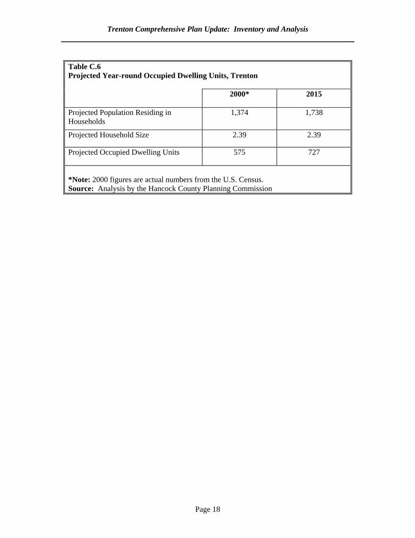
It is possible to estimate the number of year-round homes that will be built by dividing the projected household population by the projected household size. The Population chapter projected a year-round population of 1,738 for Trenton by 2015. Given a projected household population of 1,738 divided by the household size of 2.39, there would be a total of 727 year-round, occupied dwelling units in town by 2015 (see Table C.6). This would represent a 26 percent increase since 2000.
There are some factors that may lead to even more homes being built. First,
household sizes are likely to decrease as the population ages. Second, some homes may be vacant for at least part of the year; the projections are for occupied units only. They do not reflect anticipated construction in second homes.
Trenton Comprehensive Plan Update: Inventory and Analysis
Page 18
Table C.6 Projected Year-round Occupied Dwelling Units, Trenton 2000* 2015
Projected Population Residing in Households
1,374 1,738
Projected Household Size 2.39 2.39
Projected Occupied Dwelling Units 575 727
*Note: 2000 figures are actual numbers from the U.S. Census. Source: Analysis by the Hancock County Planning Commission
Page 19
D. TRANSPORTATION 1. Purpose This section will: a. identify and profile Trenton's roadway and transportation systems in terms of extent,
capacity, and use; b. assess the adequacy of those systems in handling current use demands; and c. predict whether transportation improvements will be needed to adequately
accommodate the demands generated by projected increases in population and development within Trenton and Hancock County.
2. Key Findings and Issues Traffic flows in Trenton increased steadily between 1991 and 2003. These increases ranged from around 40 percent on some segments to as much as 110 percent on another. The Maine Department of Transportation predicts continued annual increases of about 2.5 percent. At times of peak traffic flow Route 3 in Trenton is over its design capacity of 20,000 vehicles per day by about 15 percent. Since 1992 the town has taken steps to manage the traffic impacts of strip development along Route 3. As traffic continues to increase additional steps may be needed. There are also some highway safety issues that the town needs to address in cooperation with the Maine Department of Transportation. 3. Highlights of the 1992 Plan Route 3 was described as the town’s life blood and Trenton was urged to create a corridor committee. The plan recommended the designation of the Goose Cove Road as a residential street while discouraging its use as a bypass for Route 3. There were general concerns about the aesthetic, traffic and safety concerns related to strip development. 4. State, Municipal and Private Road System
a. Road Mileage and Classification
The Maine Department of Transportation (MDOT) has classified all public roads in the state. The classification system is based on the principle that the roads that serve primarily regional or statewide needs should be the state’s responsibility and roads that serve primarily local needs should be a local responsibility. The state’s classification system includes the following:
Trenton Comprehensive Plan Update: Inventory and Analysis
Page 20
Arterials: are comprised of a system of connected highways throughout the state which serve arterial or through traffic. The state is responsible for maintaining the 6.8 miles of arterial highway in Trenton. Route 3 is the only arterial serving Trenton. Collectors: serve as collectors and feeder routes connecting local service roads to the state arterial system. The state is responsible for maintaining Trenton’s 10.6 miles of collectors. However, the Town is responsible for winter maintenance of these roads. Collectors include Route 230 and Route 204. Local Roads: include all other public roads not included in the state classification system. These roads are maintained by the municipality, and based on the state system, serve primarily as local service roads, which provide access to adjacent land. Before addition of the industrial park service road, there were approximately 3.86 miles of local roads in Trenton. The park service road increased total town road mileage by about one-half mile. Some local roads may actually be functioning as collectors. Local roads with annual average daily traffic volumes greater than 200 vehicles/day and/or serving more than 25 residences could be considered collectors. The Goose Cove Road is an example. The high rate of through traffic on what is a local road is a serious concern to the town.
b. Traffic Flow
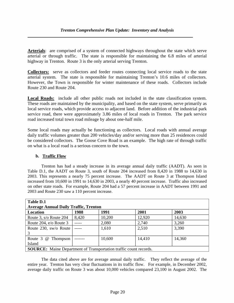
Trenton has had a steady increase in its average annual daily traffic (AADT). As seen in Table D.1, the AADT on Route 3, south of Route 204 increased from 8,420 in 1988 to 14,630 in 2003. This represents a nearly 75 percent increase. The AADT on Route 3 at Thompson Island increased from 10,600 in 1991 to 14,630 in 2003, a nearly 40 percent increase. Traffic also increased on other state roads. For example, Route 204 had a 57 percent increase in AADT between 1991 and 2003 and Route 230 saw a 110 percent increase. Table D.1 Average Annual Daily Traffic, Trenton Location 1988 1991 2001 2003 Route 3, s/o Route 204 8,420 10,200 12,920 14,630 Route 204, e/o Route 3 ----- 2,080 2,740 3,260 Route 230, sw/o Route 3
----- 1,610 2,510 3,390
Route 3 @ Thompson Island
------- 10,600 14,410 14,360
SOURCE: Maine Department of Transportation traffic count records. The data cited above are for average annual daily traffic. They reflect the average of the entire year. Trenton has very clear fluctuations in its traffic flow. For example, in December 2002, average daily traffic on Route 3 was about 10,000 vehicles compared 23,100 in August 2002. The
Trenton Comprehensive Plan Update: Inventory and Analysis
Page 21
summer peak is particularly significant since the road has a design capacity of about 20,000 vehicles per day. At peak times of travel, the road is about fifteen percent over capacity. There are also hourly fluctuations in traffic flow. According to MDOT data, the peak hours of traffic on Route 3 are between 3:00 and 5:00 PM. On August 16, 2002, the peak hourly traffic was just over 2,000 vehicles. This compares to about 1,250 vehicles on April 26, 2002. Overall, there is a different pattern in flow in the tourist season. In the off-season, traffic decreases after the morning commuting hours. During the tourist season, there is a gradual increase from 10:00 AM through 3:00 PM. This means that there is a prolonged period of high traffic flow in the summer months.
c. High Crash Locations
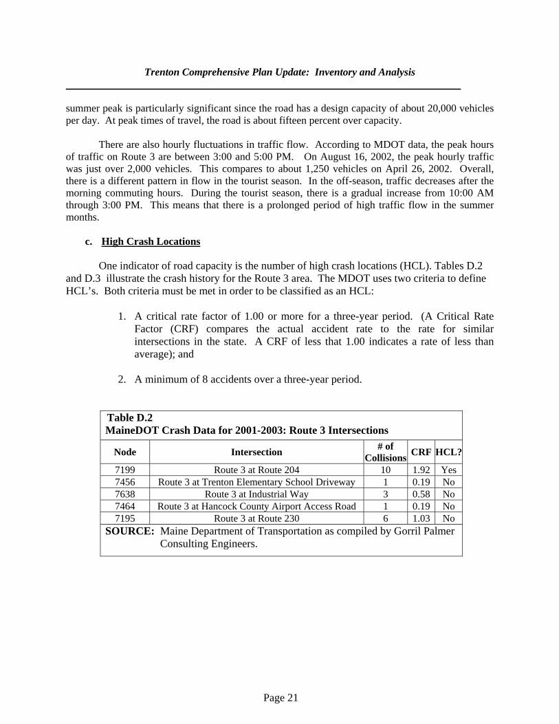
One indicator of road capacity is the number of high crash locations (HCL). Tables D.2 and D.3 illustrate the crash history for the Route 3 area. The MDOT uses two criteria to define HCL’s. Both criteria must be met in order to be classified as an HCL:
1. A critical rate factor of 1.00 or more for a three-year period. (A Critical Rate
Factor (CRF) compares the actual accident rate to the rate for similar intersections in the state. A CRF of less that 1.00 indicates a rate of less than average); and
2. A minimum of 8 accidents over a three-year period.
Table D.2 MaineDOT Crash Data for 2001-2003: Route 3 Intersections
Node Intersection # of Collisions CRF HCL?
7199 Route 3 at Route 204 10 1.92 Yes 7456 Route 3 at Trenton Elementary School Driveway 1 0.19 No 7638 Route 3 at Industrial Way 3 0.58 No 7464 Route 3 at Hancock County Airport Access Road 1 0.19 No 7195 Route 3 at Route 230 6 1.03 No
SOURCE: Maine Department of Transportation as compiled by Gorril Palmer Consulting Engineers.
Trenton Comprehensive Plan Update: Inventory and Analysis
Page 22
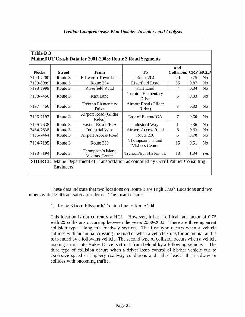
Table D.3 MaineDOT Crash Data for 2001-2003: Route 3 Road Segments
Nodes Street From To # of
Collisions CRF HCL?7199-7200 Route 3 Ellsworth Town Line Route 204 29 0.75 No 7199-8999 Route 3 Route 204 Riverfield Road 35 0.87 No 7198-8999 Route 3 Riverfield Road Kart Land 7 0.34 No
7198-7456 Route 3 Kart Land Trenton Elementary Drive 3 0.33 No
7197-7456 Route 3 Trenton Elementary Drive
Airport Road (Glider Rides) 3 0.33 No
7196-7197 Route 3 Airport Road (Glider Rides) East of Exxon/IGA 7 0.60 No
7196-7638 Route 3 East of Exxon/IGA Industrial Way 1 0.36 No 7464-7638 Route 3 Industrial Way Airport Access Road 6 0.63 No 7195-7464 Route 3 Airport Access Road Route 230 5 0.78 No
7194-7195 Route 3 Route 230 Thompson’s island Visitors Center 15 0.51 No
7193-7194 Route 3 Thompson’s island Visitors Center Trenton/Bar Harbor TL 13 1.34 Yes
SOURCE: Maine Department of Transportation as compiled by Gorril Palmer Consulting Engineers.
These data indicate that two locations on Route 3 are High Crash Locations and two others with significant safety problems. The locations are:
1. Route 3 from Ellsworth/Trenton line to Route 204 This location is not currently a HCL. However, it has a critical rate factor of 0.75 with 29 collisions occurring between the years 2000-2002. There are three apparent collision types along this roadway section. The first type occurs when a vehicle collides with an animal crossing the road or when a vehicle stops for an animal and is rear-ended by a following vehicle. The second type of collision occurs when a vehicle making a turn into Vokes Drive is struck from behind by a following vehicle. The third type of collision occurs when a driver loses control of his/her vehicle due to excessive speed or slippery roadway conditions and either leaves the roadway or collides with oncoming traffic.
Trenton Comprehensive Plan Update: Inventory and Analysis
Page 23
2. Route 3 at Route 204
This intersection is an HCL with a critical rate factor of 1.92 and ten collisions occurring between 2000-2002. There were three types of collisions that occurred at this intersection. The first type occurs when a vehicle turning left out of Route 204 collides with a vehicle headed north on Route 3. There were four such collisions between 2000-2002. The second type occurs when a vehicle making a left turn out of Route 204 collides with a vehicle making a left turn from Route 3 onto Route 204. The third collision type occurs when a vehicle waiting to make a left turn is struck from behind by a following vehicle.
3. Route 3 from Route 204 to Riverfield Road This location is currently not a HCL. However, it has a critical rate factor of 0.87 with 35 collisions occurring in the years 2000-2002. There are three apparent collision types at this location. The first collision type occurs when a vehicle collides with an animal crossing the road or a vehicle stopping for an animal crossing the road is rear-ended by a following vehicle. A second type of collision also occurs on the S-curve in which a driver loses control of his/her vehicle and leaves the roadway due to either high speed or slippery roadway conditions. A third collision type occurs when a vehicle waiting to make a left turn or in the process of making a right turn into a driveway is rear-ended by a following vehicle. The remainder of the collisions were random in nature and did not present any apparent patterns. 4. Route 3 from Thompson’s Island Visitors Center to Trenton/Bar Harbor line This location is an HCL with a critical rate factor of 1.34 and thirteen collisions occurring during the years 2000-2002 and has three apparent collision types. The first collision type occurs when a vehicle making a left turn out of a driveway collides with oncoming traffic. The second type of collision occurs when a driver loses control of his/her vehicle due to slippery roadway conditions and leaves the roadway. The third type of collision occurs when a vehicle stopped in traffic is rear-ended by a following vehicle.
The 2005 Strategic Management Plan for the Route 3 Corridor and Trenton Village identified some general traffic hazards. These included an absence of left turning lanes, the lack of signalization at critical intersections and inadequate sight distances. Problems were also noted with excessive curb cuts and hazardous parking on shoulders. According to MDOT data, there were 305 accidents reported in Trenton town-wide between 1998 and 2002. About 45 percent were rear-end or sideswipe accidents. Vehicles running off the road accounted for next most frequent percentage of accidents (19 percent),
Trenton Comprehensive Plan Update: Inventory and Analysis
Page 24
following by collisions with deer (14 percent). Another 11 percent were due to intersection movements and 5 percent to head-on/sideswipes.
The comprehensive plan committee identified several other hazardous segments in Trenton. These include both Goose Cove Road-Route 230 intersections. There are also several curves on Route 230 where accidents have occurred. Other causes accounted for much smaller proportions. 5. Railways Trenton has never had rail service and there has been no rail service in eastern and central Hancock County since 1985. There have been various proposals for passenger excursion service in the immediate Ellsworth area. 6. Airports Trenton hosts the Hancock County-Bar Harbor airport. It is served by two active runways. They are able to accommodate Gulfstream III’s and Cessna 441’s. In addition to general aviation flights, it has scheduled commuter service to Boston. It had a total of 13,996 enplanements in 2000. These had decreased to 11,906 in 2001 and 11,796 in 2002. These decreases were probably due to a combination of the aftermath of the September 11, 2001 terrorist attacks and the economic slow down those years. According to the 2004 Airport Master Plan, enplanements are expected to increase to 19,500 by 2013. There were a total of 42,500 operations in 2002 and this is expected to increase to 50,600 by 2013. The airport is an important factor in the future development in town. In addition to aviation-related businesses such as rental car agencies and fuel dealers, the airport also enhances other businesses in town. Executives are provided with easy private aircraft access to the town. Federal Aviation Administration requirements mean that there are restrictions on municipal zoning to avoid uses and activities that could interfere with flight operations. 7. Adequacy of Existing Measures to Manage Traffic Related Impacts of Development The town subdivision and land use ordinances address many traffic-related impacts of development. For example, the subdivision ordinance has detailed design standards for roads. These standards limit entrances onto existing roads and set sight distance requirements. There is also a provision that discourages the “movement of through traffic” in subdivisions. While this may help limit traffic in individual developments, it may have the unintended effect of channeling more local traffic onto existing roads. There are no requirements for the assessment of off-site traffic impacts of development. The land use ordinance limits commercial development along segments of Route 3. The Rural Commercial district allows commercial uses of up to 10,000 square-feet as a conditional
Trenton Comprehensive Plan Update: Inventory and Analysis
Page 25
use. The ordinance also has setback and off-street parking requirements. Given the large number of curb cuts along Route 3, the town may want to review its access management standards. For example, incentives could be added to encourage more sharing of driveways and further setback of curb cuts from intersections. 8. Public Transportation Trenton is served by several public transportation providers. Downeast Transportation, Inc provides weekly bus service to Ellsworth. Washington Hancock Community Agency supplies transportation to eligible clients. The Island Explorer bus offers seasonal service around MDI. There is clearly the potential for expanded public transportation in Trenton. This could include a broader Island Explorer service and more park and ride services. There could also be more subscription bus services. “Subscription” refers to buses that carry passengers from a specific area to a designated employer. For example, Jackson Lab already has several subscription buses for its commuters. 9. Local Parking Facilities, Bicycles and Sidewalks The town land use ordinance requires the provision of off-street parking for uses such as duplex and multi-family residential, commercial and manufacturing. This ordinance appears adequate to assure adequate provision of parking. The only parking problems noted are those with grandfathered uses. The land use ordinance has a number of provisions that promote aesthetically pleasing parking. These include landscaping requirements and lot coverage standards. Thirty percent is the highest lot coverage standard for commercially zoned areas. Lot coverage is defined to include parking. These standards limit the adverse impacts of any major parking facility. There are no sidewalks in town. Route 3 has a state designated bicycle shoulder. There are no other bicycle lanes or facilities in Trenton. 10. Regional Issues Trenton faces several regional transportation issues. Overall, the high rate of traffic on Route 3 is a regional problem. The town would be affected by efforts to address the traffic bottleneck in Ellsworth such as a bypass. It would also be affected by the creation of park and ride facilities in Trenton aimed at easing congestion on Mount Desert Island. It is important that the town participate in regional discussions to assure that these and other transportation developments proceed in a manner that protects Trenton’s interests. There are several issues in immediately adjoining towns that affect traffic in Trenton. First, the traffic signals at the Route 3-Route 102 intersection in Bar Harbor affects traffic flow in Trenton. Some accidents in Trenton may be due to backed-up traffic at this signal. Second, the
Trenton Comprehensive Plan Update: Inventory and Analysis
Page 26
flow of traffic is also affected by the timing of signals in Ellsworth. Third, signage in Ellsworth directing MDI-bound traffic at the Bayside-Beechland Road intersection to Route 3 (rather than to Route 230) could help eliminate through traffic on the Goose Cove Road. 11. Future Needs Traffic on Route 3 is projected to increase at a rate of 2.5 percent a year. This means that Route 3, which already exceeds its design capacity during times of peak traffic, is likely to require further improvements and or measure to manage the flow of traffic. Traffic management is likely to involve two major components. The first is assuring that highway access management measures are adequate to avoid excessive curb cuts and vehicle turning movements. The second is managing overall demand that results from through traffic. The town will also need to work with the MDOT in promoting other improvements to state roads. One needed improvement is additional left turn lanes along Route 3. Another is additional traffic signals at critical intersections.
Page 27
E. PUBLIC FACILITIES AND SERVICES 1. Purpose A thorough understanding of a town's public services is necessary to determine any current constraints to growth and identify any growth-related problems that the town is likely to face in the future. A plan should also identify likely future capital improvement needs. Specifically, this section will:
a. identify and describe Trenton's public facilities and services; and
b. assess the adequacy of these services to handle current and projected demands. Town expenditures are discussed in detail in the Fiscal Analysis Chapter. The complete Capital Investment Plan (CInP) is included in the Goals, Objectives and Implementation Section.
2. Key Findings and Issues Trenton faces no major public facility needs. Some minor improvements are needed to the fire station and the school building. At some point, additional space may be needed for town office functions. 3. Summary of the 1992 Plan The plan identified several public service deficiencies. These included a need for a new salt-sand storage shed, addressing some school facility needs and general improvements to the Route 3 corridor area. 4. Town Government
a. Current Conditions Trenton is run largely by the three-member board of selectmen. There is also a full-time administrative assistant who also serves as town clerk, treasurer and tax collector. The only other paid position is a part-time assistant. The town office functions are conducted in the town office building on the Oak Point Road. This facility also houses the fire department. It was originally built in 1952 and acquired as town office space around 1978. It includes a 144-square-foot clerk’s office, a 342-square-foot assessor’s office and a 768-square-foot conference room. Other rooms include a vault (100-square-feet), kitchen (240-square-feet), restroom (64-square-feet) and utility room (42 square-feet).
Trenton Comprehensive Plan Update: Inventory and Analysis
Page 28
b. Current and Future Adequacy
As the town government functions continue to become more demanding, additional staff may be needed. It is likely that by 2008 that a full-time assessor’s clerk will be needed to work with the assessor’s agent. The presently part-time assistant position may need to be expanded to full-time by 2010. The town eventually has to explore options for a part-time or full-time town manager. There are also several improvements that are needed to the town office building. The clerk’s office and meeting room are too small. The town vault will soon reach capacity. The town is continuing to place more records and data on computers. It is also making more information available to the public on its web site. 5. Solid Waste Disposal and Recycling
a. Current Conditions The town currently contracts with EMR in Southwest Harbor for solid waste and recycling services. Residents have access to the EMR transfer station facility. There is curbside collection of materials suitable for recycling on the third Tuesday. As of early 2006, the economics of recycling are such that the town is losing money on its recycling program. Recycling markets, however, are very volatile.
b. Current and Future Adequacy The town faces some challenges in its solid waste management policies. Options are being explored as the plan is being drafted. One is to join the Acadia Disposal District on Mount Desert Island. Another is to join the Ellsworth transfer station. 6. Fire Protection
a. Current Conditions Fire protection in Trenton is provided by the 23-member volunteer fire department. Its resources are supplemented by mutual aid arrangements with all Hancock County towns. The department has automatic mutual aid with Lamoine, Trenton, Bar Harbor and Ellsworth.
1) Facilities
The fire station is in the same building as the town office. The fire station portion was expanded in 2004. It consists of a main bay (1,700 square-feet), the new bay (1,300 square-feet)
Trenton Comprehensive Plan Update: Inventory and Analysis
Page 29
and a back bay (520 square-feet). All bays are heated. There is also a 680-square-foot meeting room, a 200-square-foot office and a 144-square-foot restroom/storage area.
2). Staffing
Six of the 23 volunteers are generally available during the day. While the department does not foresee the need for any paid day personnel, it would like to increase the number of volunteers. The department did not identify any training-related needs or concerns. Apart from standard fire department activities, the department also conducts yearly fire prevention programs in the local schools. The average response time to a call is ten minutes. The time needed to reach the most remote part of town is fifteen minutes. Road access for fire fighting equipment is generally adequate. The only exception is on some privately owned camp roads that are very narrow.
Calls for service are shown on Table E. l. As seen, they have fluctuated over the years. There is no discernable pattern of increases or decreases.
Table E.1 Fire Department Calls for Service Year Number of Calls 1997 38 1998 51 1999 31 2000 45 2001 61 2002 52 2003 61 2004 60 Source: Fire Department Records
3). Equipment
The current inventory of vehicles is shown in Table E.2. As seen, there is one pump truck that will need replacement by 2008 and another pumper that is essentially beyond its useful life. The two other trucks should be adequate until 2015 and 2023 respectively.
Trenton Comprehensive Plan Update: Inventory and Analysis
Page 30
Table E.2 Fire Department Vehicles, 2005 Type Year Condition Years of
Service Left 2,500 gallon, 1,250 gpm International 2002 Excellent 18 1,500 gallon, 750 gpm, International 1995 Excellent 10 750 gallon, 1,000 gpm, KHE 1988 Poor 3 Rescue Ford 1988 Good 10 2,000 gallon, 750 gpm pumper 1982 Poor 0 SOURCE: Trenton Fire Department
b. Current and Future Adequacy Overall, the station meets the department’s needs. No additional rooms or bays are needed. There is no need for any branch stations. Apart from replacement of existing vehicles, no new vehicles or equipment are needed. The only identified deficiency is that the main bay doors are too narrow and low. Water supply for fire fighting purposes is generally adequate. However, a dry hydrant is needed in the Bayside Road-Oak Point area. Previous efforts to install a dry hydrant in this area have been unsuccessful due to the inability to secure approval from the DEP. The dam at Odyssey Park breaches frequently. This means the dry hydrant in this area does not always have access to water. The department would like all new subdivisions to have their own water source. The Trenton fire department serves the Hancock County Airport. The Federal Aviation Administration (FAA) presently waives the requirement that there be on-site fire protection services for the airport. Trenton currently meets FAA requirements. If these requirements are made more stringent, additional fire protection services may be needed. This may involve a contract for specialized services between the county government and the Trenton fire department. 7. Police Protection
a. Current Conditions There is no municipal police department. Police protection is provided by the county sheriff and state police. There are also two municipal constables. The airport has its own security personnel.
Trenton Comprehensive Plan Update: Inventory and Analysis
Page 31
b. Current and Future Adequacy
No issues have been noted with police protection. However, any plans for major new facilities may also require consideration of additional police protection needs.
8. Ambulance Ambulance service is provided on a contractual basis by County Ambulance. No problems have been noted with the service. 9. Education a. Current Conditions K-8 education is provided by School Union 92 at the Trenton Elementary School. The facility has a rated capacity of 150 students and a current (fall 2005) enrollment of 140. There are twelve regular classrooms. Core facilities consist of a 6,240-square-foot gymnasium/community center, a 1,456-square-foot library and a 1,760-square-foot cafeteria. These facilities are adequate for current use and there is no need for any expansions. The school meets all state accreditation requirements. School Union officials have identified no pressing problems. The school building does need several minor improvements. These include better water flow and increased water storage capacity. Other needs include paving the parking area, adding emergency electrical generator capability and replacing the roof shingles in the front section of the original section of the building. The life skills program needs a kitchen area. Enrollment trends are shown in Table E.3. Enrollment increased during much of the 1990’s but then fluctuated into the first years of the current century. Total Trenton k-12 enrollment as of the fall of 2005 was 227, which was more than the 182 enrollment in 1990 but less than the peak of 258 in 1997.
Trenton Comprehensive Plan Update: Inventory and Analysis
Page 32
Table E.3 School Enrollment Trends Trenton 1991-2005 (other towns includes all towns in School Union 92)
Year K-6 7-8 9-12 Total 1990 Trenton 118 19 45 182 Other Towns 551 114 262 927
1990 Total 669 133 307 1109 1991 Trenton 130 17 48 195 Other Towns 563 122 267 952
1991 Total 693 139 315 1147 1992 Trenton 132 26 45 203 Other Towns 602 144 276 1022
1992 Total 734 170 321 1225 1993 Trenton 135 32 57 224 Other Towns 629 149 210 988
1993 Total 764 181 267 1212 1994 Trenton 121 36 62 219 Other Towns 638 173 288 1099
1994 Total 759 209 350 1318 1995 Trenton 117 42 56 215 Other Towns 636 164 288 1088
1995 Total 753 206 344 1303 1996 Trenton 122 34 73 229 Other Towns 630 158 328 1116
1996 Total 752 192 401 1345 1997 Trenton 134 38 86 258 Other Towns 608 186 327 1121
1997 Total 742 224 413 1379 1998 Trenton 131 36 84 251 Other Towns 586 200 341 1127
1998 Total 717 236 425 1378 1999 Trenton 118 39 81 238 Other Towns 584 197 364 1145
1999 Total 702 236 445 1383 2000 Trenton 131 32 72 235 Other Towns 572 185 382 1139
2000 Total 703 217 454 1374 2001 Trenton 117 41 83 241 Other Towns 550 193 391 1134
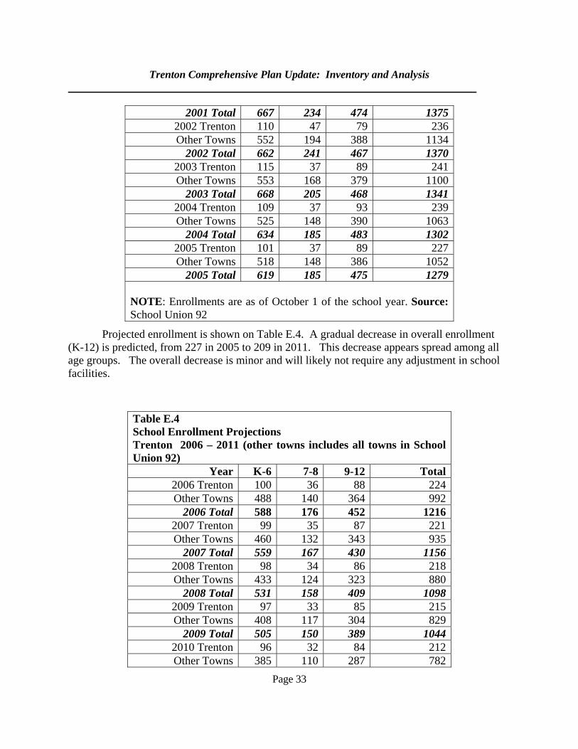
Trenton Comprehensive Plan Update: Inventory and Analysis
Page 33
Projected enrollment is shown on Table E.4. A gradual decrease in overall enrollment (K-12) is predicted, from 227 in 2005 to 209 in 2011. This decrease appears spread among all age groups. The overall decrease is minor and will likely not require any adjustment in school facilities.
2001 Total 667 234 474 1375 2002 Trenton 110 47 79 236 Other Towns 552 194 388 1134
2002 Total 662 241 467 1370 2003 Trenton 115 37 89 241 Other Towns 553 168 379 1100
2003 Total 668 205 468 1341 2004 Trenton 109 37 93 239 Other Towns 525 148 390 1063
2004 Total 634 185 483 1302 2005 Trenton 101 37 89 227 Other Towns 518 148 386 1052
2005 Total 619 185 475 1279 NOTE: Enrollments are as of October 1 of the school year. Source: School Union 92
Table E.4 School Enrollment Projections Trenton 2006 – 2011 (other towns includes all towns in School Union 92)
Year K-6 7-8 9-12 Total 2006 Trenton 100 36 88 224 Other Towns 488 140 364 992
2006 Total 588 176 452 1216 2007 Trenton 99 35 87 221 Other Towns 460 132 343 935
2007 Total 559 167 430 1156 2008 Trenton 98 34 86 218 Other Towns 433 124 323 880
2008 Total 531 158 409 1098 2009 Trenton 97 33 85 215 Other Towns 408 117 304 829
2009 Total 505 150 389 1044 2010 Trenton 96 32 84 212 Other Towns 385 110 287 782
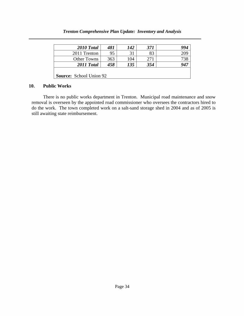
Trenton Comprehensive Plan Update: Inventory and Analysis
Page 34
10. Public Works
There is no public works department in Trenton. Municipal road maintenance and snow removal is overseen by the appointed road commissioner who oversees the contractors hired to do the work. The town completed work on a salt-sand storage shed in 2004 and as of 2005 is still awaiting state reimbursement.
2010 Total 481 142 371 994 2011 Trenton 95 31 83 209 Other Towns 363 104 271 738
2011 Total 458 135 354 947 Source: School Union 92
Page 35
F. RECREATION 1. Purpose This section will: a. describe the characteristics and use of recreation resources in Trenton and the
surrounding region; b. assess the adequacy of open space and recreation resources in meeting current and
projected demand; c. determine the adequacy of open space and scenic resource protection in Trenton; and d. assess the options for providing needed recreational additions and improvements. 2. Key Findings and Issues Town recreational facilities are very limited. Residents depend on recreational facilities and services in adjoining towns. Apart from a 54-acre piece owned by Acadia National Park on Thompson Island, there is little permanently protected open space. 3. Summary of the 1992 Plan
The plan noted that recreational facilities were limited other than what was available through the school system. There was a proposal to expand a recreational facility in conjunction with the county boat landing. 4. Recreation Sites and Programs Outdoor recreational sites in Trenton consist of the Thompson Island Picnic Area, which is managed by Acadia National Park, and the seaplane landing ramp at the airport. The school facilities, described under the Public Services and Facilities chapter, are also available for recreational use. Recreational programs in Trenton are overseen by the parks and recreation committee. The committee is supported by a town appropriation. In 2003-2004, its appropriation was $3,350. These funds were used to support the Trenton Little League, the ice rink at the school and the Ellsworth YMCA.
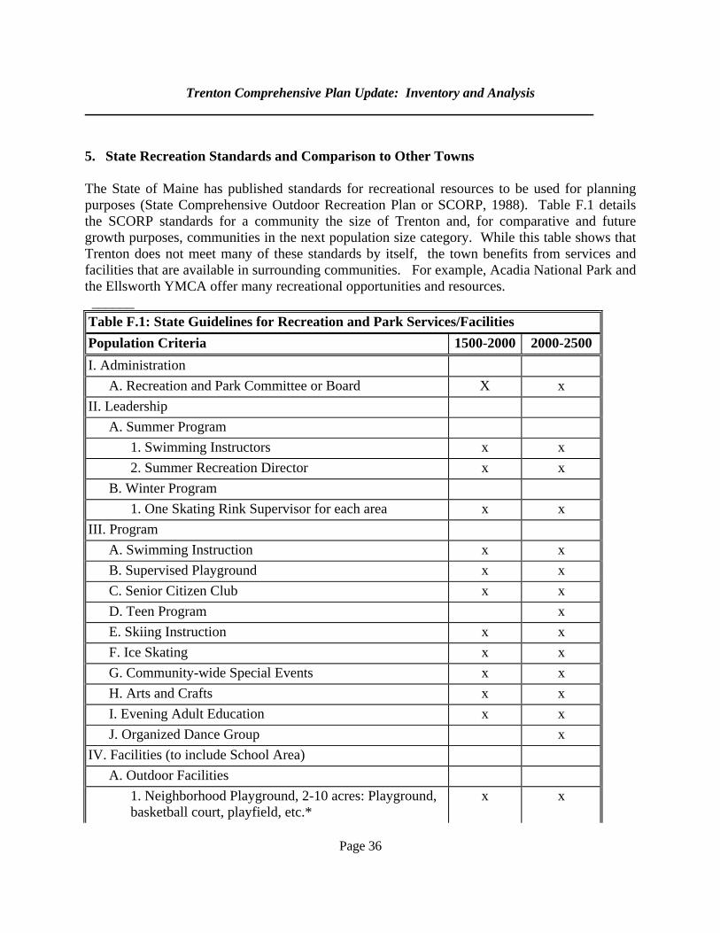
Trenton Comprehensive Plan Update: Inventory and Analysis
Page 36
5. State Recreation Standards and Comparison to Other Towns The State of Maine has published standards for recreational resources to be used for planning purposes (State Comprehensive Outdoor Recreation Plan or SCORP, 1988). Table F.1 details the SCORP standards for a community the size of Trenton and, for comparative and future growth purposes, communities in the next population size category. While this table shows that Trenton does not meet many of these standards by itself, the town benefits from services and facilities that are available in surrounding communities. For example, Acadia National Park and the Ellsworth YMCA offer many recreational opportunities and resources. ______ Table F.1: State Guidelines for Recreation and Park Services/Facilities Population Criteria 1500-2000 2000-2500 I. Administration A. Recreation and Park Committee or Board X x II. Leadership A. Summer Program 1. Swimming Instructors x x 2. Summer Recreation Director x x B. Winter Program 1. One Skating Rink Supervisor for each area x x III. Program A. Swimming Instruction x x B. Supervised Playground x x C. Senior Citizen Club x x D. Teen Program x E. Skiing Instruction x x F. Ice Skating x x G. Community-wide Special Events x x H. Arts and Crafts x x I. Evening Adult Education x x J. Organized Dance Group x IV. Facilities (to include School Area) A. Outdoor Facilities 1. Neighborhood Playground, 2-10 acres: Playground,
basketball court, playfield, etc.* x x
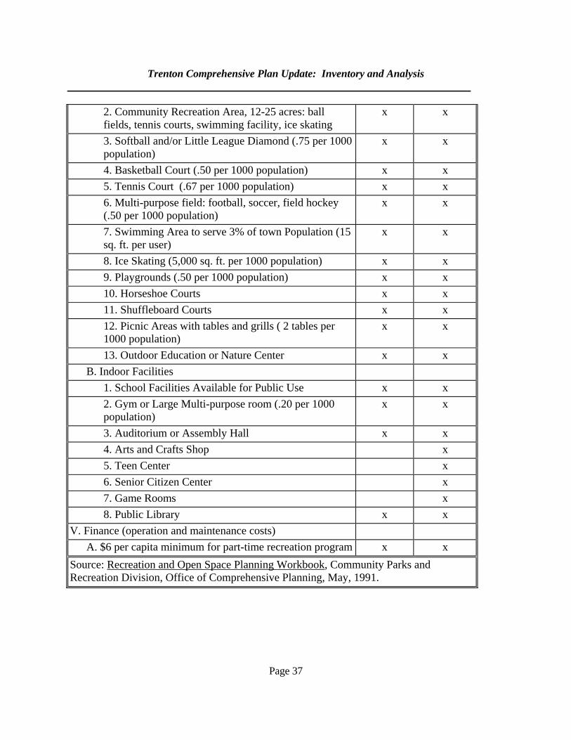
Trenton Comprehensive Plan Update: Inventory and Analysis
Page 37
2. Community Recreation Area, 12-25 acres: ball fields, tennis courts, swimming facility, ice skating
x x
3. Softball and/or Little League Diamond (.75 per 1000 population)
x x
4. Basketball Court (.50 per 1000 population) x x 5. Tennis Court (.67 per 1000 population) x x 6. Multi-purpose field: football, soccer, field hockey
(.50 per 1000 population) x x
7. Swimming Area to serve 3% of town Population (15 sq. ft. per user)
x x
8. Ice Skating (5,000 sq. ft. per 1000 population) x x 9. Playgrounds (.50 per 1000 population) x x 10. Horseshoe Courts x x 11. Shuffleboard Courts x x 12. Picnic Areas with tables and grills ( 2 tables per
1000 population) x x
13. Outdoor Education or Nature Center x x B. Indoor Facilities 1. School Facilities Available for Public Use x x 2. Gym or Large Multi-purpose room (.20 per 1000
population) x x
3. Auditorium or Assembly Hall x x 4. Arts and Crafts Shop x 5. Teen Center x 6. Senior Citizen Center x 7. Game Rooms x 8. Public Library x x V. Finance (operation and maintenance costs) A. $6 per capita minimum for part-time recreation program x x Source: Recreation and Open Space Planning Workbook, Community Parks and Recreation Division, Office of Comprehensive Planning, May, 1991.
Trenton Comprehensive Plan Update: Inventory and Analysis
Page 38
6. Open Space Open space is a concept related to recreation, which is important for a community. Open space is land which contributes to the character of the community or a neighborhood merely by being undeveloped. While much of Trenton is undeveloped, protected open space is relatively limited. Parcels include the Thompson Island picnic area (53 acres), the old fire station property (10) acres and the school property (12 acres). Since the old fire station site is now used for the salt-sand storage shed, it is of limited use for recreational open space. Much of the school property is also already developed. There are currently (2004) two parcels for a total of sixteen acres in Open Space tax protection, as described in Section J. This compares to one parcel in 1992 and 5.60 acres. Initial estimates for 2006 are that there are now 128.4 acres held in this classification. This program gives tax breaks to landowners with open space who agree not to develop it. There is presently minimal participation in this program in Trenton. 7. Scenic Resources As a peninsula community, Trenton has countless scenic views. The Bayside Road offers many views of the Union River Estuary and the east side of town overlooks the Jordan River. Portions of Routes 3 and 230 offer views of Mount Desert Island. 8. Current and Future Adequacy of Recreation, Scenic and Open Space Resources
As the town’s population continues to increase, it will likely rely primarily on adjoining towns for recreational facilities and program. However, there may be an opportunity to develop more sites in town if recreational facilities are made part of a major land development proposal.
As noted above, there is little protected open space in town. This may become a problem as the
town continues to grow. Preserving areas of open space is important in maintaining a town’s scenic and rural character. Similarly, there is little protection of scenic views.
Page 39
G. MARINE RESOURCES
1. Purpose
An understanding of marine resources is an essential element of a comprehensive plan
for any coastal community in Maine. It is particularly important in the case of Trenton since so many of its residents depend on marine resources for a living. This section aims to accomplish the following: a. Describe Trenton’s marine resource areas, harbor, and water-dependent uses in terms of access, uses and importance to the economy of Trenton and the region: b. Assess the adequacy of existing harbor facilities and public access points to handle current use demands; c. Predict whether harbor improvements will be needed to accommodate adequately the use demands of the projected population;
d. Predict whether the viability or productivity of marine resource areas, commercial fishing and other important water-dependent uses will be threatened by the impacts of growth and development.
e. Assess the effectiveness of existing measures to protect and preserve marine resource resource areas and important water-dependent uses. 2. Key Findings and Issues
While Trenton has many areas with high clam and other shell fish yields, the Goose Cove and Union River areas are presently closed to shellfish harvesting. Most economic activity directly related to marine resources in Trenton comes from lobsters. There is indirect activity from tourism and boat building.
3. A Summary of the 1992 Plan
The plan noted that Trenton had considerable marine resource habitat. With the clean-up of a few localized sources of pollution and sound resource management, these resources could be an important supplement to the local economy. 4. An Overview of Trenton’s Marine Resources
The town has extensive shellfish areas, although some are subject to closure for harvesting. The Jordan River/Bay area has an extensive soft shell clam habitat and is also a
Trenton Comprehensive Plan Update: Inventory and Analysis
Page 40
shorebird feeding area of some importance according to the U.S. Fish and Wildlife Service. Soft shell clams are abundant in the extensive mudflats located between the airport ramp and the Narrows Bridge. Soft shell clams are also abundant on both sides of the Alley Island Bar. Sand and blood worms are dug commercially on both sides of the Narrows Bridge.
Soft shell clams are found on the west side of the bridge to Haynes Point but are much
less productive than they are on the east side of the bridge. There are also shell fishing areas between the seaplane ramp, Trap Rock and north toward the mouth of the Jordan River. The U.S. Fish and Wildlife Service has identified the Goose Cove area as a prime habitat for marine worms and soft shell clams and also as an important shorebird feeding area. The Union River and Bay was once considered an excellent sea scallop area and the mouth of the river was a good marine worm habitat. The Union River has also been identified as a major anadromous fishery with alewives, rainbow smelts, blue back herring and Atlantic salmon. The area north of Mill Cove along the Trenton shore is closed to shell fishing as a result of the city of Ellsworth sewage treatment plant outflow. 5. Marine Water Quality Most of the marine waters adjacent to Trenton are classified “SB,” which is the second highest DEP classification for salt waters. It is applied to waters that are suitable for recreation, fishing, aquaculture, the propagation of harvesting of shellfish, industrial process and cooling water supply and as a habitat for fish and other marine life. Discharges that would cause the Department of Marine Resources (DMR) to close shellfish areas are prohibited. Portions of the Union River are classified “SC.” This lower classification is due at least in part to the Ellsworth sewage treatment plant. As of October 2005, Trenton had two areas that were closed to shellfish harvesting due to water quality problems (see map 3.a). The first is the Goose Cove area. The second is the Union River Bay. It should be stressed that closed areas subject to closure change periodically, so this information is subject to change. 6. Commercial Fishing As seen in Table G.1, clam harvests have fluctuated considerably in recent years. This is typical of many coastal regions. In its most productive years, Trenton has higher yields than many surrounding towns.
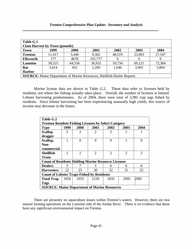
Trenton Comprehensive Plan Update: Inventory and Analysis
Page 41
Table G.1 Clam Harvest by Town (pounds) Town 1999 2000 2001 2002 2003 2004 Trenton 11,417 5,440 9,362 48,519 23,063 27,547 Ellsworth 177 4678 101,777 0 0 0 Lamoine 58,525 64,556 36,932 59,734 69,121 72,384 Bar Harbor
3,414 452 1,200 1,046 3,902 5,804
SOURCE: Maine Department of Marine Resources, Shellfish Dealer Reports Marine license data are shown in Table G.2. These data refer to licenses held by residents, not where the fishing actually takes place. Overall, the number of licenses is limited. Lobster harvesting predominates. As of 2004, there were total of 2,085 trap tags fished by residents. Since lobster harvesting has been experiencing unusually high yields, this source of income may decrease in the future.
Table G.2 Trenton Resident Fishing Licenses by Select Category Type 1999 2000 2001 2002 2003 2004 Scallop dragger
2 2 2 2 1 1
Scallop, Non-commercial
1 0 0 0 1 0
Shellfish Trans
2 2 2 2 2 2
Count of Residents Holding Marine Resource Licenses Dealers 5 7 5 6 6 6 Harvesters 22 25 30 32 31 25 Count of Lobster Traps Fished by Residents Total Trap Tags
1850 1055 1230 1835 2095 2085
SOURCE: Maine Department of Marine Resources There are presently no aquaculture leases within Trenton’s waters. However, there are two mussel farming operations on the Lamoine side of the Jordan River. There is no evidence that these have any significant environmental impact on Trenton.
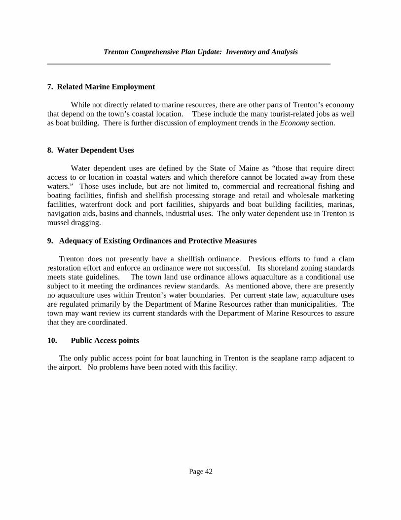
Trenton Comprehensive Plan Update: Inventory and Analysis
Page 42
7. Related Marine Employment While not directly related to marine resources, there are other parts of Trenton’s economy that depend on the town’s coastal location. These include the many tourist-related jobs as well as boat building. There is further discussion of employment trends in the Economy section. 8. Water Dependent Uses
Water dependent uses are defined by the State of Maine as “those that require direct access to or location in coastal waters and which therefore cannot be located away from these waters.” Those uses include, but are not limited to, commercial and recreational fishing and boating facilities, finfish and shellfish processing storage and retail and wholesale marketing facilities, waterfront dock and port facilities, shipyards and boat building facilities, marinas, navigation aids, basins and channels, industrial uses. The only water dependent use in Trenton is mussel dragging. 9. Adequacy of Existing Ordinances and Protective Measures
Trenton does not presently have a shellfish ordinance. Previous efforts to fund a clam
restoration effort and enforce an ordinance were not successful. Its shoreland zoning standards meets state guidelines. The town land use ordinance allows aquaculture as a conditional use subject to it meeting the ordinances review standards. As mentioned above, there are presently no aquaculture uses within Trenton’s water boundaries. Per current state law, aquaculture uses are regulated primarily by the Department of Marine Resources rather than municipalities. The town may want review its current standards with the Department of Marine Resources to assure that they are coordinated.
10. Public Access points
The only public access point for boat launching in Trenton is the seaplane ramp adjacent to the airport. No problems have been noted with this facility.
Page 43
H. WATER RESOURCES
1. Purpose It is the purpose of this section to:
a. describe the characteristics, uses, and quality of Trenton's significant water resources;
b. predict whether the quantity or quality of significant water resources will be threatened by the impacts of future growth and development; and
c. assess the effectiveness of existing measures to protect and preserve significant water
resources. 2. Key Findings and Issues Residents generally depend on private wells for their water supply. Apart from a few isolated case of salt water intrusion into wells, ground water quality is generally good. The town has three major drainage areas: the Union River, Goose Cove and the Jordan River. 3. Summary of the 1992 Plan The plan mentioned that although water quality was generally good, there were limits to the amount of ground water that could be removed. This was particularly the case in Oak Point and Haynes Point areas of town. The Big Heath, wetland areas and groundwater recharge areas were particularly important water-related features. 4. Ponds and Watersheds There are no great ponds (naturally occurring freshwater lakes of ten acres or more) in Trenton. There are three major drainage areas, the Jordan River, the Union River and Goose Cove. All three drain into salt water. The Jordan River drainage includes all of the Route 3 corridor and that portion of Route 204 that lies within Trenton. A major portion of the drainage runs into Foster Brook and Crippens Creek, the rest drains directly into the Jordan River/Bay. The Goose Cove drainage includes the McFarland Brook drainage as well as the drainage to Western Bay from the east side of the West Trenton and Oak Point Ridges. Route 230 bisects this area. The Union River drainage is the largest drainage area in town. It includes the Heath Brook, Lords Brook and the Big Heath drainages. Route 230, the Cross Road and many minor shore property access roads are found in this area. Land uses in this section of town are predominantly residential.
Trenton Comprehensive Plan Update: Inventory and Analysis
Page 44
5. Freshwater Wetlands
Freshwater wetlands are defined as those areas commonly referred to as swamps, bogs, or
marshes that are inundated or saturated by surface or ground water at a frequency and for a duration sufficient to support, and which under normal circumstances do support, a prevalence of wetland vegetation typically adapted for life in saturated soils. Wetlands larger than 10 acres (“designated wetlands”) are subject to the shoreland zoning setback standards. Wetlands 0.1 to 10 acres in size are subject to regulation by the Maine Dept. of Environmental Protection under the Natural Resources Protection Act.
6. Rivers and Streams The town, on its water side, is largely bounded by the Union River and Jordan River and their respective bays. The Union River estuary consists of 794 acres and the entire watershed, including those parts outside the estuary, is about 563 square-miles. The watershed is 60 miles-long and up to 45 miles-wide. There are about 4,848 miles of freshwater streams feeding the estuary. The tidal head of the estuary is in downtown Ellsworth, approximately 3.75 miles from its seaside boundary. The Jordan River watershed is much smaller. It consists of about 10.6 square-miles. Both rivers are important features of Trenton due to their natural and scenic values. As mentioned above, there are also several streams in town. Information on fisheries resources in these streams can be found in the Natural Resources section. Freshwater quality in Trenton is generally good. Most streams are classified by the DEP as “B-1”, which means that they are essentially unimpaired for habitat and suitable for drinking purposes after adequate treatment. However, Fosters (Stony) Brook is classed at “C” from its crossing on Route 3 to the tidewater. 7. Coastal Wetlands.
Maine’s Natural Resources Protection Act defines coastal wetlands as tidal or subtidal land. They are identified by the presence of salt-tolerant wetland plants or the presence of a tidal debris line, and include mudflats, beaches, and salt marsh. Coastal wetlands serve as nurseries and food sources for larger fish and provide wintering areas for waterfowl and staging areas for migratory shorebirds. They protect coastlines from erosion and provide open space for recreation and fishing. All coastal wetlands are protected by NRPA, regardless of size; but it is also important to protect the upland areas draining into coastal areas. Trenton’s coastal wetlands are shown on Map 3.
Trenton Comprehensive Plan Update: Inventory and Analysis
Page 45
8. Flood Hazard Areas
Flood hazard areas, as mapped by the federal government, are shown on Map 3. The town has enacted a flood plain management ordinance, which sets development standards for land uses within flood-prone areas. By having a flood plain management ordinance that meets state and federal guidelines, property owners in Trenton are eligible for flood insurance. As of 2003, there were ten properties in town that had flood insurance. Between 1989 and 2003, there was only one claim paid and it amounted to $160. Given the limited number of claims, the town appears to face no major flood hazard issues. Its ordinance currently meets all state and federal standards.
9. Ground Water
Ground water is defined as subsurface water found in the saturated soils and water bearing bedrock of the earth's surface. Its upper level, which rises and falls seasonally, is called the water table. A bedrock aquifer is a rock formation that contains recoverable volumes of ground water. All ground water is important to a community as a source of drinking water, and aquifers are especially important, while also especially vulnerable to pollution from surface and subsurface sites. The majority of Trenton residents depend on private wells for their domestic water supply. Most of these wells are located in bedrock areas, which is less permeable than sand and gravel areas. While adequate for private, domestic use bedrock well yields may be inadequate for larger scale uses. Overall, ground water quality appears adequate. There have been cases in the Haynes Point and Oak Point areas where there has been salt water infiltration into wells. 10. Public Water Systems
Public water systems are defined as those that serve a given number of the general public even if they are not publicly owned. They may be as large as a system serving a neighborhood or downtown area or as small as one serving a restaurant. These systems are subject to various state regulations and reporting requirements. According to data from the Maine Drinking Water Program, there are 22 public systems in Trenton. They are summarized on Table H.1 and shown on Map 3. The systems are all located adjacent to Route 3. They include motels, schools and major employers.
The map shows the “public water supply source water protection area.” This area is
defined as the “area that contributes recharge water to a surface water intake or public water supply well.” Operators of these systems, per state law, must be notified of land use decisions that could affect the source water protection area. This allows the operators to participate in the
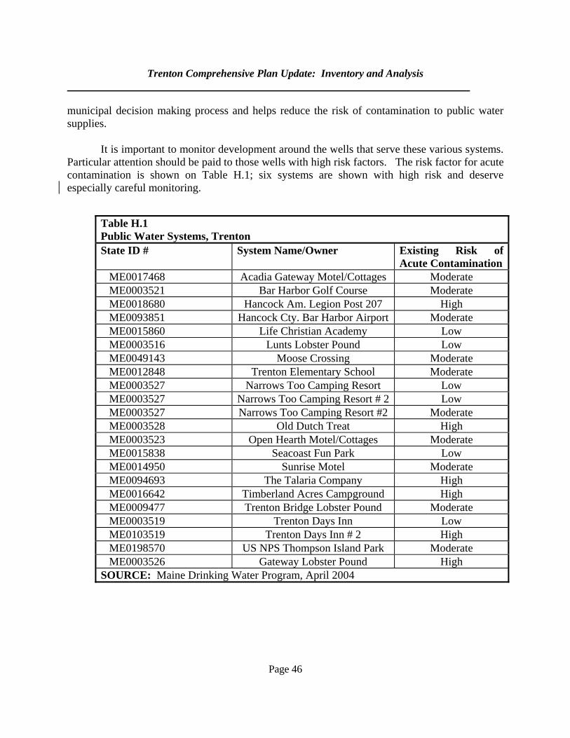
Trenton Comprehensive Plan Update: Inventory and Analysis
Page 46
municipal decision making process and helps reduce the risk of contamination to public water supplies.
It is important to monitor development around the wells that serve these various systems. Particular attention should be paid to those wells with high risk factors. The risk factor for acute contamination is shown on Table H.1; six systems are shown with high risk and deserve especially careful monitoring.
Table H.1 Public Water Systems, Trenton State ID # System Name/Owner Existing Risk of
Acute ContaminationME0017468 Acadia Gateway Motel/Cottages Moderate ME0003521 Bar Harbor Golf Course Moderate ME0018680 Hancock Am. Legion Post 207 High ME0093851 Hancock Cty. Bar Harbor Airport Moderate ME0015860 Life Christian Academy Low ME0003516 Lunts Lobster Pound Low ME0049143 Moose Crossing Moderate ME0012848 Trenton Elementary School Moderate ME0003527 Narrows Too Camping Resort Low ME0003527 Narrows Too Camping Resort # 2 Low ME0003527 Narrows Too Camping Resort #2 Moderate ME0003528 Old Dutch Treat High ME0003523 Open Hearth Motel/Cottages Moderate ME0015838 Seacoast Fun Park Low ME0014950 Sunrise Motel Moderate ME0094693 The Talaria Company High ME0016642 Timberland Acres Campground High ME0009477 Trenton Bridge Lobster Pound Moderate ME0003519 Trenton Days Inn Low ME0103519 Trenton Days Inn # 2 High ME0198570 US NPS Thompson Island Park Moderate ME0003526 Gateway Lobster Pound High
SOURCE: Maine Drinking Water Program, April 2004
Trenton Comprehensive Plan Update: Inventory and Analysis
Page 47
11. Existing and Potential Threats
There are two different types of water pollution: point source, and non-point source. Point source pollution is that which comes from a specific source, such as a pipe, and can easily be identified, measured, licensed, or removed. Nonpoint pollution is much broader and less simple to identify. It ranges from storm water runoff to leaking gasoline tanks, agricultural, lawn, and forestry runoff.
According to DEP records, all overboard discharges (wastewater systems discharging
into saltwater) in Trenton have been removed. All problems related to such discharges have thus been addressed. No other point sources have been identified. There are no specifically identified non-point sources. 12. Regional Considerations The town faces several regional water quality issues. First, it would benefit from regional efforts to improve the water quality of the Union River. Second, it could work with other towns on shellfish restoration efforts. Third, it may want to coordinate steps to protect the quality of the Jordan River with Lamoine and Hancock. 13. Adequacy of Existing Protection Measures The Trenton land use ordinance has standards to manage the water quality impacts from new development. These include lot coverage ratios, storm water run off and erosion and sedimentation standards. The latter two standards are fairly general and do not provide the planning board with detailed guidelines. Given the amount of commercial and other non-residential development that is occurring in Trenton, the town may want to enact more detailed standards. It may also want to review its impervious surface ratios for uses such as parking lots and other uses that may cover large areas of land.
Page 48
I. NATURAL RESOURCES
1. Purpose This section will: a. describe Trenton's critical natural resources in terms of their extent,
characteristics, and significance; b. predict whether the existence, physical integrity, or quality of critical natural
resources will be threatened by the impacts of future growth and development; and
c. assess the effectiveness of existing measures to protect and preserve critical
natural resources. 2. Key Findings and Issues The town’s natural resources include a bald eagle essential habitat area and a roseate tern habitat. Almost all of the coastline is waterfowl and wading bird habitat. Trenton also has two deer wintering areas and some of its brooks are important sea-rainbow smelt runs. 3. Summary of the 1992 Plan The plan noted the town’s diversity of wildlife and fisheries. No major issues were apparent at that time. 4. Areas Identified by Maine’s Beginning with Habitat Program The Beginning with Habitat initiative, which is a program coordinated by various agencies including the Maine Department of Inland Fisheries and Wildlife, the Maine Natural Area Program and the Maine Audubon Society has mapped key natural resources in Trenton (see Map 3.b). Some of these resources are subject to state regulation under the Natural Resources Protection Act (NRPA). This act set standards to protect key natural features such as certain wildlife habitats, wetlands and other water bodies from adverse impacts of development. Certain habitats are subject to protection by the Maine Endangered Species Act. Almost of all of Trenton’s coastline is tidal waterfowl and wading bird habitat. Waterfowl habitat consists of areas where breeding, migration, staging and wintering takes place. Wading bird habitats are also used for feeding and loafing. These areas have not been officially adopted as habitat subject to NRPA regulation. There are also some freshwater waterfowl and wading bird habitat.
Trenton Comprehensive Plan Update: Inventory and Analysis
Page 49
The town also has one area of bald eagle essential habitat. This is a site that is within a nesting territory during at least one of three recent years and has been either intact for two consecutive years or is the only extant nest in the territory. Bald eagle habitats are protected by the Maine Endangered Species Act. Any action requiring a state or local permit within one-quarter mile of the site requires review by the MDIFW. Eagle nests are particularly sensitive to disruption during nesting season from about February 1 through August 31. There is also an area of upland sandpiper habitat, which is a threatened species. Upland sandpipers are among the rarest grassland birds in the Northeast. It was listed as threatened in 1997 because of small populations, regional population declines and diminishing habitats in the Northeast. Development proposals in this habitat should be reviewed by the MDIFW. Trenton has an area of American sea-blite (suada calceoformis). This is a critically imperiled plant in Maine due to its extreme rarity or vulnerability to extirpation. It has been found in a total of nine towns in Maine. It occurs near the upper tidal limit of salt marshes and along the sandy or gravelly shores. Sea-blites are succulent kalophytes with flowers borne in clusters of three in the axils of the leaves. The town’s five wetlands that are over ten acres in size are ranked as significant wildlife habitats. As such they are subject to the NRPA. Here again, development proposals that affect these habitats require MDIFW review.
5. Other Natural Features
Inland Trenton, particularly those areas near and around the town’s wetlands and heath, is home to several species of wildlife. Large mammals known to inhabit this area include deer, and on occasion, moose and bear. Smaller animals include rabbits, porcupines, raccoons, coyote and fox. There are two deer wintering areas. One is located near Oak Point and is approximately 90 acres in size. The other consists of about 45 acres and located at the head of Goose Cove. The town’s deer yards are not subject to protection under the NRPA. As is discussed in the Existing Land Use section, Trenton still has large parcels of undeveloped land. Unbroken stretches of rural land are important in preserving habitat since they allow animals unbroken access to sources of food and other features essential to their survival. According to data supplied by the Beginning With Habitat program, Trenton has two large areas of largely undeveloped land. There is a 6,700-acre piece in the interior, north of Goose Cove Road and a 1,500-acre piece south of that road. These pieces are not held in single ownership and continued development of smaller parcels is likely.
Trenton Comprehensive Plan Update: Inventory and Analysis
Page 50
6. Fresh Water Fisheries There are several small streams and brooks that are or have been important sea-rainbow smelt runs. Lords, Heath, Cuppers, Fosters and Goose Cove Brooks are considered by the DMR as important fishing habitat.
7. Threats and Existing Protection The major threat to natural resources is from continued development. However, the Trenton subdivision ordinance has standards to protect significant habitat areas. The ordinance requires that the applicant demonstrate that the development will have no adverse impact on the habitat and the species it supports. The ordinance gives the planning board the right to require that a report be prepared by a wildlife biologist to assess the impacts of the proposed development. The report must also describe mitigating measures the applicant can take to avoid adverse environmental impacts.
Page 51
J. AGRICULTURAL AND FOREST RESOURCES 1. Purpose This section presents an overview of Trenton's agricultural and forest resources. Specifically, this section will:
a. describe the extent of Trenton's farms and forest lands;
b. predict whether the viability of these resources will be threatened by the impacts of growth and development; and
c. assess the effectiveness of existing measures to protect and preserve
important farm and forest resources. 2. Key Findings and Issues
Farming and forestry are very limited in Trenton. There is minimal farming and only 1,467 acres in timber harvests were reported to the Maine Forest Service between 1991 and 2003.
3. Highlights of the 1992 Plan The plan mentioned that forestry and agriculture were not major contributors to the Trenton economy, but that small farms and woodlots were important sources of family income. These lands also contributed to the town’s overall character. 4. Agricultural Resources According to data from the Natural Resources Conservation Service, Trenton has 245 acres of prime agricultural soils and 2,356 acres of farmland soils of statewide importance. The term “prime agricultural soils” refers to those soils that have the potential to have the highest agricultural yields, they are not necessarily farmed. The “soils of statewide importance” category refers to soils that have a more modest potential yield. Agricultural soils account for about 23 percent of the town’s total land area of 11,452 acres. Another way to estimate current amounts of agricultural land is through the acreage of land held under the Farm and Open Space Act. This act allows farmland owners property tax breaks for parcels over five contiguous acres if they meet certain conditions such as a minimum farm-derived income. Normally, qualifying farmers with a long-term commitment to farming would participate in this program. A review of state records indicates that there were only 378 acres held in this farmland classification in most recent years (see Table J.1). This means that farming is very limited in Trenton.
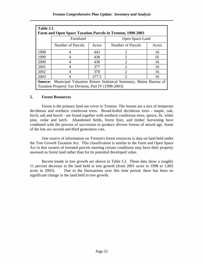
Trenton Comprehensive Plan Update: Inventory and Analysis
Page 52
Table J.1 Farm and Open Space Taxation Parcels in Trenton, 1998-2003 Farmland Open Space Land
Number of Parcels Acres Number of Parcels Acres
1998 4 443 2 16 1999 4 438 2 16 2000 4 438 2 16 2001 4 377 2 16 2002 4 378 2 16 2003 4 377.5 2 16 Source: Municipal Valuation Return Statistical Summary, Maine Bureau of Taxation Property Tax Division, Part IV (1998-2003)
5. Forest Resources Forest is the primary land use cover in Trenton. The forests are a mix of temperate deciduous and northern coniferous trees. Broad-leafed deciduous trees - maple, oak, birch, ash and beech - are found together with northern coniferous trees, spruce, fir, white pine, cedar and larch. Abandoned fields, forest fires, and timber harvesting have combined with the process of succession to produce diverse forests of mixed age. Some of the lots are second and third generation cuts. One source of information on Trenton's forest resources is data on land held under the Tree Growth Taxation Act. This classification is similar to the Farm and Open Space Act in that owners of forested parcels meeting certain conditions may have their property assessed as forest land rather than for its potential developed value.
Recent trends in tree growth are shown in Table J.2. These data show a roughly 11 percent decrease in the land held in tree growth (from 2001 acres in 1998 to 1,805 acres in 2003). Due to the fluctuations over this time period, there has been no significant change in the land held in tree growth.
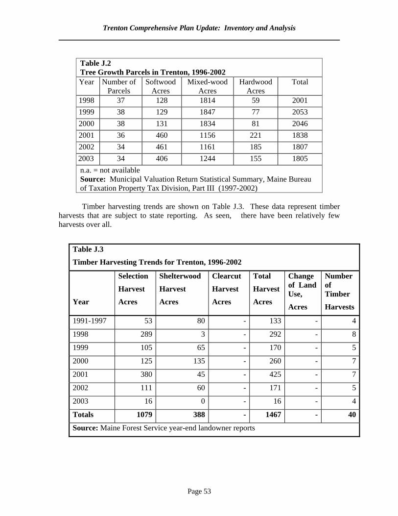
Trenton Comprehensive Plan Update: Inventory and Analysis
Page 53
Table J.2 Tree Growth Parcels in Trenton, 1996-2002 Year Number of
Parcels Softwood
Acres Mixed-wood
Acres Hardwood
Acres Total
1998 37 128 1814 59 2001 1999 38 129 1847 77 2053 2000 38 131 1834 81 2046 2001 36 460 1156 221 1838 2002 34 461 1161 185 1807 2003 34 406 1244 155 1805 n.a. = not available Source: Municipal Valuation Return Statistical Summary, Maine Bureau of Taxation Property Tax Division, Part III (1997-2002)
Timber harvesting trends are shown on Table J.3. These data represent timber
harvests that are subject to state reporting. As seen, there have been relatively few harvests over all.
Table J.3
Timber Harvesting Trends for Trenton, 1996-2002
Year
Selection
Harvest
Acres
Shelterwood
Harvest
Acres
Clearcut
Harvest
Acres
Total
Harvest
Acres
Change of Land Use,
Acres
Number of Timber
Harvests
1991-1997 53 80 - 133 - 4
1998 289 3 - 292 - 8
1999 105 65 - 170 - 5
2000 125 135 - 260 - 7
2001 380 45 - 425 - 7
2002 111 60 - 171 - 5
2003 16 0 - 16 - 4
Totals 1079 388 - 1467 - 40
Source: Maine Forest Service year-end landowner reports
Trenton Comprehensive Plan Update: Inventory and Analysis
Page 54
6. An Analysis of Threats to Farm and Forest Land from Projected Development
The major threat is a gradual reduction of the currently forested area. The town’s remaining farms could also be sold for development as Trenton continues to grow. 7. Adequacy of Existing Measures to Protect Farm and Forest Land
While there are no direct measures in the town’s land use ordinances to protect farm and forest land, there are several measures that facilitate their protection. First, the tree growth tax classification offers at least temporary protection. Over the long term, there is no guarantee that land not be withdrawn from this classification and sold for development. Second, there are shoreland zoning standards for timber harvesting. Third, the subdivision ordinance provisions for the retention of natural beauty and the preservation of open space may help protect forested areas. The town ordinances could benefit from more specific guidelines.

Page 55
K. HISTORIC AND ARCHAEOLOGICAL RESOURCES
1. Purpose This section will:
a. outline the history of the town of Trenton;
b. identify and profile the historic and archaeological resources of Trenton in terms of their type and significance;
c. assess current and future threats to the existence and integrity of those resources; and
d. assess the effectiveness of existing measures to protect and preserve those resources;
and.
2. Key Findings and Issues While there are no buildings in Trenton listed on the National Registry of Historic Places, it is likely that there are many homes that are eligible for listing. There are fourteen pre-historic shell midden sites that were used by the Native Americans and one historic archaeological site. 3. Summary of the 1992 Plan The plan mentioned that a comprehensive survey of Trenton’s historic resources needed to be conducted to identify those properties which may be eligible for nomination to the National Registry of Historic Places. Additional data collection was needed to identify archaeological resource potential areas. 4. Town History Long before the discovery and settlement of the Maine coast by Europeans, various Indian groups inhabited the area. Archaeological excavations in this region suggest that a non-agricultural tribe, referred to as the Red Paint or the Moorehead People, frequented the region as long as 5,000 years ago. These Indians followed seasonal fluctuations in food supply, hunting seal, and porpoise for food and oil and catching fish and shellfish along the coast. It is possible that an even earlier prehistoric Indian group inhabited the region shortly after the end of the last Ice Age, some 10,000 years ago. Since 2000 B.C., Algonquin Indians moved in from the south and west, forming the Abnaki group (Indian for “living at the sunrise”). The Abnaki pursued a semi-agricultural, semi-hunting and gathering livelihood, wintering on the coast and summering inland. Abnaki progeny of historic times, known today as Penobscots and Passamaquoddies, probably reversed this pattern wintering inland and summering along the coast. This change may have occurred partly as a result of the European exploration and the subsequent demand for furs, which necessitated that
Trenton Comprehensive Plan Update: Inventory and Analysis
Page 56
Indians hunt inland in the winter-time to supply the fur traders. Summers were spent on the coast by these tribes as recently as the late 1800’s. Although their visits have not been documented, Northern European fishermen probably visited the coast prior to the 1500’s. Temporary settlements may have been built by these fishermen. Explorers of the 15th and 16th centuries, notably Cabot for England, Verrazano and Thavet for France and others for Portugal and Spain, sailed along Maine’s coast, making claims for their respective countries. In the early 17th century, French geographer Samuel de Champlain visited and mapped the region, which had been claimed by earlier French explorers. Champlain was a member of the 1604 expedition of Pierre du Guast, the Sieur de Monts, to whom King Henry IV of France had granted the land known as Acadia. De Monts, Champlain, and others established a temporary settlement at St. Croix, which was also part of the grant. It is doubtful, however, that de Monts himself visited the Mount Desert area. A few years after de Monts was granted Acadia, the King of France granted Madame de Geurcheville the area including Mount Desert Island and the nearby mainland. She sent a group of Jesuit priests to colonize the area. Settling on nearby Mount Desert Island, the Jesuits were attacked and their settlement destroyed within weeks by Sam Argail and a British fishing party on orders from the Jamestown Colony to destroy any French settlement they found. It is believed that Madame de Guercheville lived for a brief time after that at Trenton Point. In 1688 the King of France transferred the title to Sieur de Cadillac, granting the Mount Desert Island and the mainland around the Donaqua River, which is presumably the Indian name for the Union River. Following the Revolutionary War, Cadillac’s granddaughter, Madame de Gregoire, claimed the land which had been granted Cadillac. In 1787 the Massachusetts Legislature granted de Gregoire some 6,000 acres, including much of Trenton and portions of towns of Mount Desert Island. The de Gregoires lived awhile in Mount Desert, holding the only French claim in Maine. Present titles to property in this area go back to the de Gregoire claim of 1787. Around the same time that Champlain visited the area claimed by the French, British explorers were visiting the same area, which had also been claimed for the British crown. Two explorers are notable: Martin Pring, who explored the Penobscot Bay area extensively in 1603, and Captain George Weymouth, who visited in 1605. A temporary British settlement was located at Popham, further west on the coast, in 1607. No permanent settlements were made in the immediate area until the end of the French and Indian Wars around 1760, when the British triumphed and claimed the entire region. In 1762 the Massachusetts Bay Colony established six townships between the Penobscot and Donaqua Rivers and six townships east of the Donaqua River. These townships were granted to David Marsh and others under certain conditions of settlement. Those conditions included inhabiting each township with 60 Protestant families who would build houses and cultivate the land within six years.
Trenton Comprehensive Plan Update: Inventory and Analysis
Page 57
Trenton, Number 1 of the six “second-class townships” to the east of the Union, was ceded in 1762 to Eben Thorndike, and then confirmed to Paul Thorndike by the Commonwealth of Massachusetts in 1785. The first British settlement was made here in 1763 by Thorndike and other settlers who were attracted to the area by the opportunities for fishing and growing crops. The first division of lots was made on Oak Point in 1764, when 66 lots were laid out. Settlers drew 60 of these lots by lottery and proceeded to clear the land and build houses. First called Thornbury or Thorndike Plantation, Trenton was incorporated in 1789 and named after the 1776 Battle of Trenton, New Jersey. The population in 1789 was about 300 people. In 1798 the settlement located at the head of the Union River was set off and, along with portions of other townships, incorporated as the town of Ellsworth. Lamoine was considered a part of Trenton until it was incorporated in 1870. A portion of Mount Desert Island now belongs to Trenton because of a minor disagreement in 1848 between the Thompson family who owned Thompson’s Island and the town of Eden, now Bar Harbor. When Eden assessors valued his property too high, Colonel Thompson successfully petitioned the State Legislature to remove his property from that town and annex it to Trenton. As in many other coastal towns, lumbering, farming, and fishing were the primary occupations for Trenton residents in the past. The early settlers engaged in all three activities. Timber was cut from the abundant forests and sawmills built to turn the logs into lumber, which were traded for essential supplies. Fishing provided food for the early settlers and their families. Farming consisted of growing grain and vegetables for the settlers’ own use. Eventually a general store was built, where settlers could trade their fish and farm products for household goods. The proprietor, Mr. Hopkins, also built a windmill for grinding the settlers’ corn into meal. In the late 1800’s Trenton residents became involved in the coastal carrying trade, granite and ice, to Boston and New York markets and returning with supplies. Many townspeople were employed as sea captains and sailors on the large coasting vessels. Others owned two-masted schooners which carried lumber, granite, bricks, and other building materials to Mount Desert Island when summer estates were being built there in the late 1800’s. Lumber was Trenton’s major product during the years of the coasting trade. Many residents employed in woodcutting or at the large lumber mill located at the “Millcove” at Bayside. Owned by Whitcomb, Haynes and Whitney, the Trenton Lumber Company operated from the late 1800’s until 1924. The Union River was an active place for lumbering operations, both because of the mill at Bayside and because of the lumber trade from Ellsworth, located upriver from Trenton. The Union River was also the site of considerable shipbuilding activity. Applebee’s Sailing Vessels Built in the Frenchman’s Bay District, Maine lists over 60 vessels which were built at Trenton between 1830 and 1860. For the most part, farming has continued to be a subsistence activity, as it was during the early settlement years. Poultry, beef and dairy farming has existed on a small scale along both the Jordan and Union Rivers. Some vegetable farming has also existed. The few large dairy farms which were in operation along the Jordan River several decades ago have since become a country club and other tourist related businesses.
Trenton Comprehensive Plan Update: Inventory and Analysis
Page 58
Fishing, which did not play a major role in Trenton’s development, was generally considered a secondary occupation to many residents. Weirs were built along the coast, with the fish sold locally. Fish and shellfish have been an important resource throughout the town’s history, however. Town records for 1791 show that a fine of forty shillings was imposed on anyone not belonging to the town who was caught digging clams within the town’s boundaries. Trenton did not play an active part in the quarrying industry which was so important to other coastal towns in the latter 1800’s. The 1881 Colby Atlas for Hancock County does list a silver mine along the Jordan River, but it is unlikely that the mine produced ore of any quantity or quality. A brickyard was operated at Bayside for a brief time around the turn of the century. A major aluminum reduction plant was proposed in Trenton in 1969, under the conditions than an atomic power plant and an industrial park be built to provide necessary services to the aluminum plant. Development of the industrial park which was necessary to attract that industry was voted down by Trenton residents. Prior to the construction of the Trenton Bridge across the Mount Desert Narrows to Mount Desert Island, a ferry was operated by the Thompson family, who owned Thompson’s Island and the land at the Narrows. Several attempts were made to build a bridge here, including an unsuccessful try in 1826. Ten years later the Mount Desert Bridge Corporation succeeded in building a toll bridge, complete with a draw span to allow vessels to pass through. It quickly became the property of two local families, the Thompson’s and the Somes, who owned and maintained it until the County took it over in 1917. The present cement bridge was completed in 1960. Although Trenton did not experience as much activity from summer visitors during the resort period of the late 1800’s as did Mount Desert Island and other coastal towns, Trenton has had its share of the summer tourist trade. The area of town known as Shady Nook has been inhabited by a small colony of summer residents since the late 1800’s. 5. Identified Pre-Historic, Historic and Archaeological Sites Archaeological sensitive zones have been identified and are mapped on the Trenton Natural Resources Map. A total of fourteen (14) prehistoric archaeological sites are located along Trenton’s coast. These are “shell middens” which are Indian campsites. In Trenton, numerous shell heaps were surveyed and excavated in the early 1900’s by Dr. Warren K. Moorehead and his team from Boston’s Peabody Museum. More recently, an archaeological team from the University of Maine surveyed sites in the Frenchman Bay region. Shell heaps containing evidence of habitation have been surveyed on Western bay at Oak Point and Alley’s Island, and along the Jordan River. Prehistoric shell middens and associated campsites are found near the shore just north of the Bar Harbor airport. The only historic archaeological site is the Thompson family complex, an early American settlement. The Maine Historic Preservation Commission (MHPC) indicates that there is a need for further survey of Trenton’s historic archaeological resources. There has been no
Trenton Comprehensive Plan Update: Inventory and Analysis
Page 59
professional survey done to date. Future fieldwork could focus on agricultural, residential and industrial sites relating to the earliest Euro-American settlement beginnings in the 1760s. As of April 2005, MHPC data indicate that there were no properties in Trenton that were listed in the National Register of Historic Places. The agency recommended that a comprehensive survey be done to identify properties that may be eligible to be placed on the Register. Given the large number of older homes, it is likely that many properties are eligible. 6. Adequacy of Existing Protection Efforts
The Trenton subdivision regulations have provisions that require if any portion of a proposed development is designated a site of historic or prehistoric archaeological significance by the comprehensive plan or the MHPC, “appropriate measures” for the protection of these resources “shall be included in the application submissions.” Since there are no detailed guidelines on what these measures are, the current provisions are very general.
There is also a provision in the zoning ordinance that requires that any proposed land use
activity involving structural development or soil disturbance on or adjacent to sites eligible for listing on the National Register of Historic Places be submitted to the MHPC for review and comment. The permitting authority is required to consider the comments before making a decision. 7. Threats and Planning Implications As mentioned above, the town has only general guidelines in its historic and archaeological resource protection measures. A larger issue is the lack of a complete survey of the town’s historic resources. This means that there is the risk of important features being destroyed by development simply because the planning board may not be aware of their existence.
Page 60
L. LAND USE
1. Purpose It is the purpose of this section to: a. identify and understand the uses of land throughout Trenton in terms of the amounts and
location of land generally devoted to various land use classifications; b. identify and understand changes in Trenton's land use patterns and how they might reflect
future land use patterns; and c. identify land areas suitable and unsuitable as the primary locations for the growth and
development predicted for the next ten years. 2. Key Findings and Issues Trenton has seen continued commercial and residential development. There has also been a dramatic increase in manufacturing development. One issue facing the town is the lack of a defined village center. The town is expected to see another 550 acres developed by 2015. 3. Summary of the 1992 Plan The town was already experiencing considerable land development. It had about 1,000 acres in residential uses and 250 acres in commercial and manufacturing uses. There were a total of four manufacturing operations. 4. Overview Trenton has continued to grow since 1992. Several general trends are evident. First, there has been significant manufacturing development. This is due both to the opening of the Trenton Business Park and other operations that have opened elsewhere in town. Second, there has been continued commercial development, especially along Route 3. Both commercial and manufacturing development trends are summarized in Table L.1 Third, there has been continued residential development. Residential subdivisions from 1995 to 2003 are shown in table L.2. A total of 39 lots were approved and homes were constructed on 21 lots. There has also been considerable single lot home construction. A review of building permits indicates that 73 permits for new homes were issued between 2000 and 2005. As was discussed in the Housing chapter, the total number of dwelling units increased from 670 to 816 between 1990 and 2000. This represents an increase of 146 units or nearly 22 percent. As was mentioned in the housing chapter, there was a 31 percent increase in rental units during this period. More apartment buildings are being built in town.
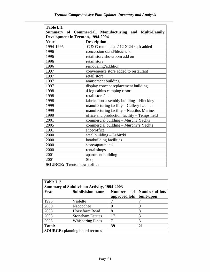
Trenton Comprehensive Plan Update: Inventory and Analysis
Page 61
Table L.1 Summary of Commercial, Manufacturing and Multi-Family Development in Trenton, 1994-2004 Year Description 1994-1995 C & G remodeled / 12 X 24 sq ft added 1996 concession stand/bleachers 1996 retail store showroom add on 1996 retail store 1996 remodeling/addition 1997 convenience store added to restaurant 1997 retail store 1997 amusement building 1997 display concept replacement building 1998 4 log cabins camping resort 1998 retail store/apt 1998 fabrication assembly building – Hinckley 1999 manufacturing facility – Gallery Leather 1999 manufacturing facility – Nautilus Marine 1999 office and production facility – Tempshield 2001 commercial building – Murphy Yachts 2005 commercial building – Murphy’s Yachts 1991 shop/office 2000 steel building – Lebitzki 2000 boatbuilding facilities 2000 store/apartments 2000 rental shops 2001 apartment building 2001 Shop SOURCE: Trenton town office
Table L.2 Summary of Subdivision Activity, 1994-2003 Year Subdivision name Number of
approved lotsNumber of lots built-upon
1995 Violette 7 7 2000 Nacoochee 0 0 2003 Horsefarm Road 8 8 2003 Stoneham Estates 17 3 2003 Whispering Pines 7 3 Total: 39 21 SOURCE: planning board records
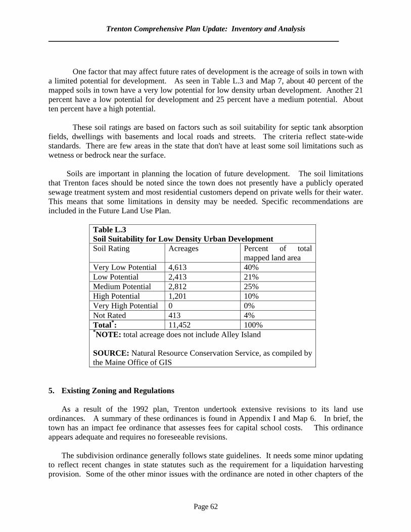
Trenton Comprehensive Plan Update: Inventory and Analysis
Page 62
One factor that may affect future rates of development is the acreage of soils in town with a limited potential for development. As seen in Table L.3 and Map 7, about 40 percent of the mapped soils in town have a very low potential for low density urban development. Another 21 percent have a low potential for development and 25 percent have a medium potential. About ten percent have a high potential. These soil ratings are based on factors such as soil suitability for septic tank absorption fields, dwellings with basements and local roads and streets. The criteria reflect state-wide standards. There are few areas in the state that don't have at least some soil limitations such as wetness or bedrock near the surface. Soils are important in planning the location of future development. The soil limitations that Trenton faces should be noted since the town does not presently have a publicly operated sewage treatment system and most residential customers depend on private wells for their water. This means that some limitations in density may be needed. Specific recommendations are included in the Future Land Use Plan.
Table L.3 Soil Suitability for Low Density Urban Development Soil Rating Acreages Percent of total
mapped land area Very Low Potential 4,613 40% Low Potential 2,413 21% Medium Potential 2,812 25% High Potential 1,201 10% Very High Potential 0 0% Not Rated 413 4% Total*: 11,452 100% *NOTE: total acreage does not include Alley Island SOURCE: Natural Resource Conservation Service, as compiled by the Maine Office of GIS
5. Existing Zoning and Regulations As a result of the 1992 plan, Trenton undertook extensive revisions to its land use ordinances. A summary of these ordinances is found in Appendix I and Map 6. In brief, the town has an impact fee ordinance that assesses fees for capital school costs. This ordinance appears adequate and requires no foreseeable revisions. The subdivision ordinance generally follows state guidelines. It needs some minor updating to reflect recent changes in state statutes such as the requirement for a liquidation harvesting provision. Some of the other minor issues with the ordinance are noted in other chapters of the
Trenton Comprehensive Plan Update: Inventory and Analysis
Page 63
Inventory and Analysis. Of particular importance may be more stringent provisions for access management. There are presently eight zones in the zoning ordinance. These include a Residential District, Gateway Commercial District, Airport Commercial Industrial, Trenton Business Park, Rural Commercial, Rural Development, Resource Protection and Village District. There are also two overlay districts; one for the Route 3 Corridor and the other for the airport area. The latter follows FAA (Federal Aviation Administration) standards regarding heights and other measures related to airport safety. While the zoning ordinance is adequate overall, there are several provisions that may need to be reviewed. Specific issues related to access management are addressed in the Transportation chapter. A more general issue is impervious surface ratios. While there are lot coverage standards, these are less meaningful if there is a large-scale development. For example, a 50-acre development in the Gateway Commercial zone, which has a 30 percent lot coverage ratio, could have as much as fifteen acres of lot coverage. The town may want to set limits on the extent of unbroken impervious surface allowed in one development. 6. Land Use Issues Trenton faces several land use issues. The first is that development along Route 3 faces increased rates of traffic. This makes difficult for residents to stop and patronize local businesses since it is hard to leave and enter the flow of traffic. The second (and related issue) is that Trenton does not have a defined village center where compact residential uses and small-scale commercial operations can locate in a harmonious and pedestrian friendly manner. The third issue is that they are large areas of poor soils in town. This means that it would be difficult for higher density development to occur in many areas. 7. Land Needed for Future Development The future residential acreage can be estimated by multiplying the expected number of dwelling units by the average required lot size. Table C.6 in the Housing chapter indicates that there would be approximately 152 dwelling units in town by 2015, which would mean 152 additional residential acres (assuming one acre per unit). To allow for some unforeseen growth, it will be assumed that 300 additional residential acres would be needed. There is no set way to estimate future non-residential acreage, which would include the land needed for commercial and manufacturing uses. It can be assumed, however, that Trenton will continue to attract such development. As a general estimate, at least 250 additional non-residential acres can be expected. The combined residential land (300 acres) and non-residential land (250 acres) amounts to 550 acres of additional developed land. It is also possible that there will be additional acreage placed in conservation land, but there is no way to estimate the amount. Estimating the acreage
Trenton Comprehensive Plan Update: Inventory and Analysis
Page 64
of land needed in the future is important in planning to assure that enough land is zoned in a way that facilitates development. 8. Regional Implications
Trenton is affected by development in adjoining towns. As land prices increase on Mount Desert Island, Trenton is likely to experience more development. Similarly, there is likely to be continued spillover from the high rate of commercial development in Ellsworth. Trenton may want to monitor development rates in the immediate region to help it assess likely future growth rates.
Page 65
M. FISCAL CAPACITY
1. Purpose
It is important to understand a municipality’s tax base and its various fiscal challenges. A town’s fiscal capacity affects its ability to pay for new services related to growth and development and growth trends in turn affect the tax base. This section will:
a. discuss Trenton’s fiscal conditions; b. assess recent expenditure and revenue trends; and c. discuss likely future trends.
2. Key Findings and Issues
While the town’s total valuation increased by a pre-inflation rate of 88 percent between 1993 and 2004, tax assessments increased by 106 percent during the same period. This means that expenditures are increasing at a faster rate than the tax base and residents are facing higher property taxes. Education is the largest expenditure in the town budget, it accounted for about 90 percent of all expenditures in 2004. About 80 percent of municipal revenues are from property taxes and 9 percent are from excise taxes. State revenue sharing and impact fees account for a smaller portion of revenues.
3. Summary of the 1992 Plan
The plan mentioned that per capita expenditures were increasing at a faster rate than the valuation. The increases in valuation meant a decrease in state school funding. School costs accounted for the majority of increased spending. Other expenditures increased at a more modest scale. 4. Valuation and Tax Assessment
The town’s ability to raise taxes depends largely on the total value of all property in town. The change in state valuation for Trenton is shown on Table M.1. Between 1993 and 2004, the total valuation in town increased by about 88 percent. When adjusted for inflation, there was an actual increase of about 37 percent.
Tax assessments (shown on Table M.2) increased at a much faster rate than the
valuation. Assessments increased by 106 percent between 1993 and 2004. When adjusted for inflation, the actual increase was 50 percent. Trenton land owners are thus facing continued increases in property taxes.
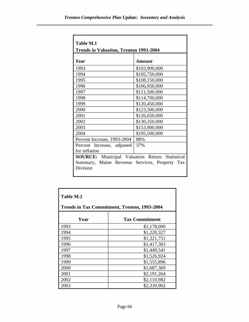
Trenton Comprehensive Plan Update: Inventory and Analysis
Page 66
Table M.1 Trends in Valuation, Trenton 1993-2004
Year Amount 1993 $103,900,000 1994 $105,750,000 1995 $108,150,000 1996 $106,950,000 1997 $111,500,000 1998 $114,700,000 1999 $120,450,000 2000 $123,500,000 2001 $126,650,000 2002 $130,350,000 2003 $153,900,000 2004 $195,500,000 Percent Increase, 1993-2004 88% Percent Increase, adjusted for inflation
37%
SOURCE: Municipal Valuation Return Statistical Summary, Maine Revenue Services, Property Tax Division
Table M.2
Trends in Tax Commitment, Trenton, 1993-2004
Year Tax Commitment 1993 $1,178,000 1994 $1,220,327 1995 $1,321,751 1996 $1,417,303 1997 $1,449,541 1998 $1,526,924 1999 $1,555,896 2000 $1,687,369 2001 $2,191,264 2002 $2,110,982 2003 $2,339,902
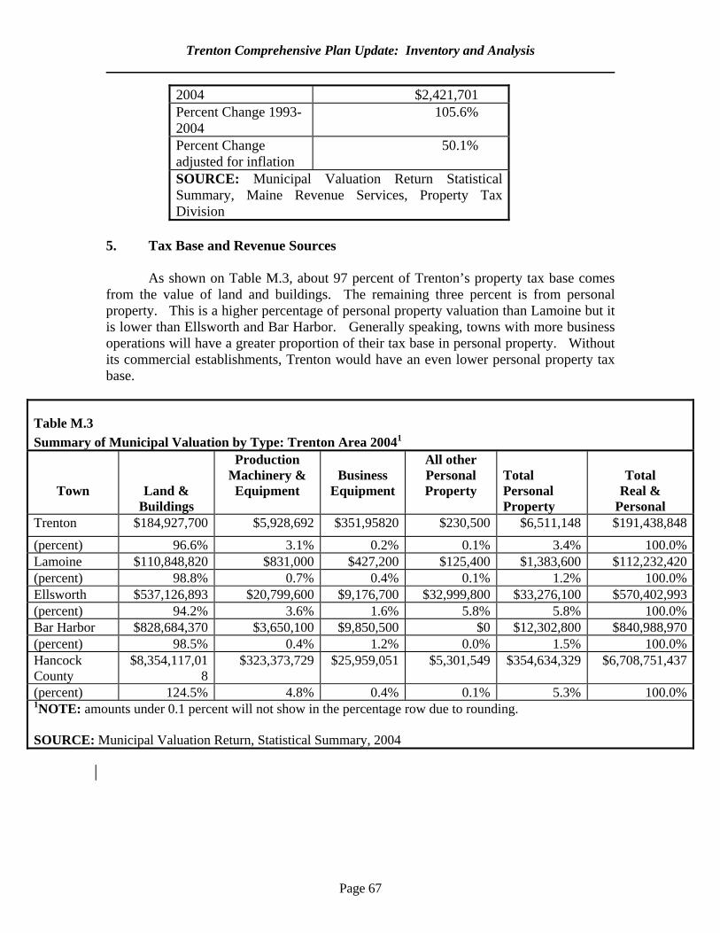
Trenton Comprehensive Plan Update: Inventory and Analysis
Page 67
2004 $2,421,701 Percent Change 1993-2004
105.6%
Percent Change adjusted for inflation
50.1%
SOURCE: Municipal Valuation Return Statistical Summary, Maine Revenue Services, Property Tax Division
5. Tax Base and Revenue Sources
As shown on Table M.3, about 97 percent of Trenton’s property tax base comes from the value of land and buildings. The remaining three percent is from personal property. This is a higher percentage of personal property valuation than Lamoine but it is lower than Ellsworth and Bar Harbor. Generally speaking, towns with more business operations will have a greater proportion of their tax base in personal property. Without its commercial establishments, Trenton would have an even lower personal property tax base.
Table M.3 Summary of Municipal Valuation by Type: Trenton Area 20041
Town
Land & Buildings
Production Machinery & Equipment
Business
Equipment
All other Personal Property
Total Personal Property
Total
Real & Personal
Trenton $184,927,700 $5,928,692 $351,95820 $230,500 $6,511,148 $191,438,848
(percent) 96.6% 3.1% 0.2% 0.1% 3.4% 100.0%Lamoine $110,848,820 $831,000 $427,200 $125,400 $1,383,600 $112,232,420(percent) 98.8% 0.7% 0.4% 0.1% 1.2% 100.0%Ellsworth $537,126,893 $20,799,600 $9,176,700 $32,999,800 $33,276,100 $570,402,993(percent) 94.2% 3.6% 1.6% 5.8% 5.8% 100.0%Bar Harbor $828,684,370 $3,650,100 $9,850,500 $0 $12,302,800 $840,988,970(percent) 98.5% 0.4% 1.2% 0.0% 1.5% 100.0%Hancock County
$8,354,117,018
$323,373,729 $25,959,051 $5,301,549 $354,634,329 $6,708,751,437
(percent) 124.5% 4.8% 0.4% 0.1% 5.3% 100.0%1NOTE: amounts under 0.1 percent will not show in the percentage row due to rounding. SOURCE: Municipal Valuation Return, Statistical Summary, 2004
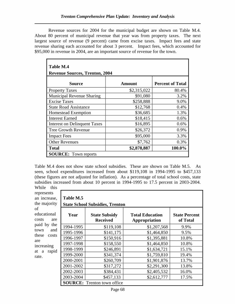
Trenton Comprehensive Plan Update: Inventory and Analysis
Page 68
Revenue sources for 2004 for the municipal budget are shown on Table M.4. About 80 percent of municipal revenue that year was from property taxes. The next largest source of revenue (9 percent) came from excise taxes. Impact fees and state revenue sharing each accounted for about 3 percent. Impact fees, which accounted for $95,000 in revenue in 2004, are an important source of revenue for the town.
Table M.4 does not show state school subsidies. These are shown on Table M.5. As seen, school expenditures increased from about $119,108 in 1994-1995 to $457,133 (these figures are not adjusted for inflation). As a percentage of total school costs, state subsidies increased from about 10 percent in 1994-1995 to 17.5 percent in 2003-2004. While this represents an increase, the majority of educational costs are paid by the town and these costs are increasing at a rapid rate.
Table M.4 Revenue Sources, Trenton, 2004
Source Amount Percent of Total Property Taxes $2,315,022 80.4% Municipal Revenue Sharing $91,080 3.2% Excise Taxes $258,888 9.0% State Road Assistance $12,768 0.4% Homestead Exemption $36,685 1.3% Interest Earned $18,415 0.6% Interest on Delinquent Taxes $16,895 0.6% Tree Growth Revenue $26,372 0.9% Impact Fees $95,000 3.3% Other Revenues $7,762 0.3% Total $2,878,887 100.0% SOURCE: Town reports
Table M.5 State School Subsidies, Trenton
Year State Subsidy Received
Total Education Appropriation
State Percent of Total
1994-1995 $119,108 $1,207,568 9.9% 1995-1996 $141,175 $1,464,850 9.5% 1996-1997 $150,916 $1,395,881 10.8% 1997-1998 $158,550 $1,464,850 10.8% 1998-1999 $246,891 $1,634,721 15.1% 1999-2000 $341,374 $1,759,810 19.4% 2000-2001 $260,709 $1,901,876 13.7% 2001-2002 $317,272 $2,291,300 13.8% 2002-2003 $384,431 $2,405,532 16.0% 2003-2004 $457,133 $2,612,777 17.5% SOURCE: Trenton town office
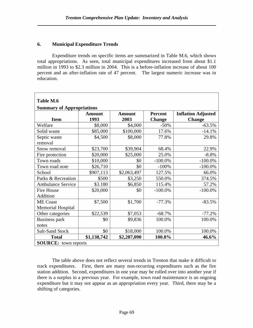
Trenton Comprehensive Plan Update: Inventory and Analysis
Page 69
6. Municipal Expenditure Trends
Expenditure trends on specific items are summarized in Table M.6, which shows total appropriations. As seen, total municipal expenditures increased from about $1.1 million in 1993 to $2.3 million in 2004. This is a before-inflation increase of about 100 percent and an after-inflation rate of 47 percent. The largest numeric increase was in education.
Table M.6 Summary of Appropriations
Item
Amount 1993
Amount 2003
Percent Change
Inflation Adjusted Change
Welfare $8,000 $4,000 -50% -63.5%Solid waste $85,000 $100,000 17.6% -14.1%Septic waste removal
$4,500 $8,000 77.8% 29.8%
Snow removal $23,700 $39,904 68.4% 22.9%Fire protection $20,000 $25,000 25.0% -8.8%Town roads $10,000 $0 -100.0% -100.0%Town road note $26,710 $0 -100% -100.0%School $907,113 $2,063,497 127.5% 66.0%Parks & Recreation $500 $3,250 550.0% 374.5%Ambulance Service $3.180 $6,850 115.4% 57.2%Fire House Addition
$20,000 $0 -100.0% -100.0%
ME Coast Memorial Hospital
$7,500 $1,700 -77.3% -83.5%
Other categories $22,539 $7,053 -68.7% -77.2%Business park notes
$0 $9,836 100.0% 100.0%
Salt-Sand Stock $0 $18,000 100.0% 100.0%Total $1,138,742 $2,287,090 100.8% 46.6%
SOURCE: town reports
The table above does not reflect several trends in Trenton that make it difficult to
track expenditures. First, there are many non-recurring expenditures such as the fire station addition. Second, expenditures in one year may be rolled over into another year if there is a surplus in a previous year. For example, town road maintenance is an ongoing expenditure but it may not appear as an appropriation every year. Third, there may be a shifting of categories.
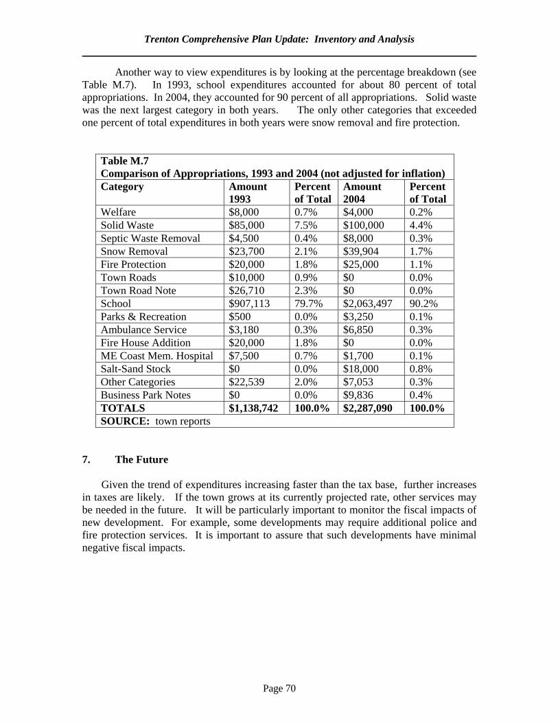
Trenton Comprehensive Plan Update: Inventory and Analysis
Page 70
Another way to view expenditures is by looking at the percentage breakdown (see Table M.7). In 1993, school expenditures accounted for about 80 percent of total appropriations. In 2004, they accounted for 90 percent of all appropriations. Solid waste was the next largest category in both years. The only other categories that exceeded one percent of total expenditures in both years were snow removal and fire protection.
Table M.7 Comparison of Appropriations, 1993 and 2004 (not adjusted for inflation) Category Amount
1993 Percent of Total
Amount 2004
Percent of Total
Welfare $8,000 0.7% $4,000 0.2% Solid Waste $85,000 7.5% $100,000 4.4% Septic Waste Removal $4,500 0.4% $8,000 0.3% Snow Removal $23,700 2.1% $39,904 1.7% Fire Protection $20,000 1.8% $25,000 1.1% Town Roads $10,000 0.9% $0 0.0% Town Road Note $26,710 2.3% $0 0.0% School $907,113 79.7% $2,063,497 90.2% Parks & Recreation $500 0.0% $3,250 0.1% Ambulance Service $3,180 0.3% $6,850 0.3% Fire House Addition $20,000 1.8% $0 0.0% ME Coast Mem. Hospital $7,500 0.7% $1,700 0.1% Salt-Sand Stock $0 0.0% $18,000 0.8% Other Categories $22,539 2.0% $7,053 0.3% Business Park Notes $0 0.0% $9,836 0.4% TOTALS $1,138,742 100.0% $2,287,090 100.0% SOURCE: town reports
7. The Future
Given the trend of expenditures increasing faster than the tax base, further increases in taxes are likely. If the town grows at its currently projected rate, other services may be needed in the future. It will be particularly important to monitor the fiscal impacts of new development. For example, some developments may require additional police and fire protection services. It is important to assure that such developments have minimal negative fiscal impacts.
Page 71
N. INVENTORY AND ANALYSIS SUMMARY
1. Purpose
This chapter is a summary of the Inventory and Analysis phase of the comprehensive plan. It summarizes the key issues Trenton faces and serves as the major focus of the Goals and Objectives. The first part of the chapter identifies the most pressing issues. The second part summarizes each chapter. These summaries are taken verbatim from the Key Issues and Findings section of each individual chapter. The third part identifies the major regional issues in the greater Trenton area.
2. Priority Issues Trenton faces several priority issues. One is the continued increases in traffic flow.
Another is achieving a balance between maintaining a healthy business climate and avoiding the sort of business development along Route 3 that may intensify traffic congestion. A third issue is the high cost of housing in relation to median income, which is making it harder for younger families to move to town. At the same time, the even higher housing prices on nearby Mount Desert Island, mean that the town has attracted considerable residential development. The town risks losing some of its rural, coastal character. A fourth issue is high property tax rates.
3. Key Findings and Issues
A. Population Trenton is one of the fastest growing towns in Hancock County. Its year-round population increased by 29 percent between 1990 and 2000. The town’s 2015 population is projected to be 1,738, which is 26 percent more than its 2000 population of 1,374. The town’s residential population is estimated to more than double during the peak summer and this figure does not include the vast number of day visitors, or the people who work in town. The town’s population is aging. Those in the 45-64 age group increased by 51 percent.
B. Economy Trenton’s labor force increased from 524 persons in 1990 to 708 in 2000. There are no major differences in employment patterns in Trenton and in the county as a whole. However, unemployment rates in town are generally below the county average. The town has attracted many new and expanded businesses. More people commute into Trenton than commute out of town.
Trenton Comprehensive Plan Update: Inventory and Analysis
Page 72
C. Housing
The total number of dwelling units in Trenton increased by 22 percent between 1990 and 2000. The number of rental units increased by almost double the rate for Hancock County as a whole. While median household incomes in Trenton increased by 9.4 percent between 2001 and 2004, the median sales price of a house increased by 45 percent during the same period. The number of year-round, occupied units is projected to increase by 26 percent between 2000 and 2015,
D. Transportation Traffic flows in Trenton increased steadily between 1991 and 2003. These increases ranged from around 40 percent on some segments to as much as 110 percent on another. The Maine Department of Transportation predicts continued annual increases of about 2.5 percent. At times of peak traffic flow Route 3 in Trenton is over its design capacity of 20,000 vehicles per day by about 15 percent. Since 1992 the town has taken steps to manage the traffic impacts of strip development along Route 3. As traffic continues to increase additional steps may be needed. There are also some highway safety issues that the town needs to address in cooperation with the Maine Department of Transportation.
E. Public Facilities and Services Trenton faces no major public facility needs. Some minor improvements are needed to the fire station and the school building. At some point, additional space may be needed for town office functions.
F. Recreation Town recreational facilities are very limited. Residents depend on recreational facilities and services in adjoining towns. Apart from a 54-acre piece owned by Acadia National Park on Thompson Island, there is little permanently protected open space. G. Marine Resources
While Trenton has many areas with high clam and other shell fish yields, the Goose Cove and Union River areas are presently closed to shellfish harvesting. Most economic activity directly related to marine resources in Trenton comes from lobsters. There is indirect activity from tourism and boat building.
Trenton Comprehensive Plan Update: Inventory and Analysis
Page 73
H. Water Resources Residents generally depend on private wells for their water supply. Apart from a few isolated case of salt water intrusion into wells, ground water quality is generally good. The town has three major drainage areas: the Union River, Goose Cove and the Jordan River.
I. Natural Resources
The town’s natural resources include a bald eagle essential habitat area and a roseate tern habitat. Almost all of the coastline is waterfowl and wading bird habitat. Trenton also has two deer wintering areas and some of its brooks are important sea-rainbow smelt runs.
J. Agricultural and Forest Resources
Farming and forestry are very limited in Trenton. There is minimal farming and
only 1,467 acres in timber harvests were reported to the Maine Forest Service between 1991 and 2003.
K. Historical and Archaeological Resources While there are no buildings in Trenton listed on the National Registry of Historic Places, it is likely that there are many homes that are eligible for listing. There are fourteen pre-historic shell midden sites that were used by the Native Americans and one historic archaeological site.
L. Existing Land Use Trenton has seen continued commercial and residential development. There has also been a dramatic increase in manufacturing development. One issue facing the town is the lack of a defined village center. The town is expected to see another 550 acres developed by 2015.
M. Fiscal Capacity
While the town’s total valuation increased by a pre-inflation rate of 88 percent between 1993 and 2004, tax assessments increased by 106 percent during the same period. This means that expenditures are increasing at a faster rate than the tax base and residents are facing higher property taxes. Education is the largest expenditure in the town budget, it accounted for about 90 percent of all expenditures in 2004. About 80 percent of municipal revenues are from property taxes and 9 percent are from excise taxes. State revenue sharing and impact fees account for a smaller portion of revenues.
Trenton Comprehensive Plan Update: Inventory and Analysis
Page 74
4. Key Regional Issues
One regional issue is traffic and related transportation matters. Trenton has the only road access to the Mount Desert Island, which attracts millions of summer visitors. Effective traffic management requires a regional approach.
Another regional issue is economic development. The success of the Trenton
Business Park shows the high demand for land devoted to manufacturing. To assure continued job opportunities, the town may want to participate in county-wide economic development ventures. Trenton residents benefit from jobs created elsewhere in the region.
Housing is also a regional issue. Due to its lack of publicly owned water and
sewer systems, there is limited infrastructure for high density housing. At the same time, there may be pressures from nearby towns on Mount Desert Island to create more lower cost housing in mainland towns. Trenton needs to find a balance between addressing its share of regional housing needs while avoiding assuming a disproportionate amount of lower cost housing.

Page 75
SECTION II
GOALS AND OBJECTIVES
Page 76
II.A. GOALS, OBJECTIVES and IMPLEMENTATION 1. Purpose This section presents goals and objectives for Trenton. Goals are general statements for the town's future and are followed by more specific objectives. As will be seen, these goals and objectives are often interrelated. The goals and objectives are followed by implementation strategies that explain how each goal will be achieved. While this plan contains some highly specific recommendations, residents are reminded that planning is an ongoing process. To assure flexibility in the event of unforeseen circumstances, periodic updating of these goals is necessary. 2. Overall Goal Trenton seeks to promote orderly growth while preserving its coastal, rural character and its high quality of life. It encourages a strong local economy that provides sustainable jobs. 3. Goals and Objectives A. POPULATION GOAL
Trenton wishes to be a community with a year-round population composed of all age groups. It also wishes to sustain its seasonal population. The plan recommends that these goals be accomplished by the following steps:
1. Undertake measures to promote a balanced, year-round economy (see Economy goals) so
that families of working age have access to jobs; 2. Support measures to increase opportunities for first time homebuyers so that younger
families have easier access to housing (see Housing goals); and 3. Undertake measures to maintain the town’s quality of life so that it remains attractive to
second home owners and vacationers. (this is addressed throughout the plan).
Implementation Strategy: This is addressed through other goals and objectives in the plan. Responsibility: As indicated elsewhere in the plan.
Time Frame: As indicated elsewhere in the plan. B. ECONOMY GOAL
Trenton seeks to promote an economy that offers its residents a variety of well paying year-round jobs both within the town and within easy commuting distance. It also seeks to preserve its important seasonal sources of employment, encourage home-based businesses and
Trenton Comprehensive Plan Update: Goals, Objectives & Implementation
Page 77
local entrepreneurial activities. The plan recommends that these goals be accomplished through the following specific measures:
1. Regional Coordination: The plan recommends that Trenton participate in regional efforts to diversify the Hancock County economy. This will include ongoing involvement with the Coastal Acadia Development Corporation (or its successor organization) and supporting endeavors of other state and regional organizations that promote this goal;
Implementation Strategy: This is a continuation of current policy
2. Assistance to Existing Businesses: The plan supports measures to help business retain and create jobs. Specific steps include, but are not limited to, seeking state grant and loan funds for necessary public infrastructure, interim financing and job training;
Implementation Strategy: The town contacts area economic development groups to ascertain what grant programs would meet the town’s needs and recommends to the select board which funds should be sought. Joint grant applications with adjoining towns shall be considered whenever deemed feasible. Responsibility: select board. Time Frame: ongoing 3. Home-Based Occupations: The plan recommends that home-based occupations
continue to be permitted in all parts of town unless prohibited by state-mandated shoreland zoning standards;
Implementation Strategy: This is addressed through the Future Land Use Plan and the proposed changes to the land use ordinances.
4. Business Park Expansion: The plan recommends that town support the expansion of the existing business parks;
Implementation Strategy: The town retains its current zoning that allows such uses. It seeks grant funds and/or tax increment financing to create additional lots with utilities and other services. It works with a regional organization to market the sites. Responsibility: select board Timeframe: 2007-2009
5. Village Business Development: The plan recommends that town encourage the development of businesses oriented toward local consumption in the proposed village area. This would be accomplished by assuring that zoning allowed small-scale business operations in an area served by a local street network;
Trenton Comprehensive Plan Update: Goals, Objectives & Implementation
Page 78
Implementation Strategy: The general zoning changes are recommended in the future land use plan. These would be part of the overall town land use ordinance revisions. Responsibility: planning board or designee Timeframe: 2007-2009
C. HOUSING GOAL Trenton seeks to have a diversity of housing stock and opportunities for persons of all income levels to live in the town. In addition to addressing its existing affordable housing gap, it aims to have least ten percent of its new housing be affordable to persons of low to moderate income. This will be accomplished through the following specific measures:
1. First-time Homebuyer Subdivision: The town will work with the Maine State Housing Authority and other housing professionals to create subdivisions that will offer a portion of the homes for sale to households in the median household income range for Hancock County. The town would not become a housing provider, but rather would facilitate this process by pursuing appropriate grants that could be administered by an organization experienced in such ventures. The subdivisions would be located in the proposed village area as shown in the future land use plan. All roads would be built to town standards in the event that the homeowners and the town agree that the road should be recommended for acceptance as a public way at a town meeting;
Implementation Strategy: The select board appoints a community housing committee to work with the various housing agencies to determine what grant programs are best suited to the town. The committee recommends to the select board what grants should be sought and if tax increment financing or other locally generated sources of match should be pursued. Responsibility: Community Housing Committee takes lead. Time Frame: Select board appoints committee in 2007, grant submitted by 2009
2. Improvement of Existing Housing Stock: The town will seek funds from the Community Development Block Grant program and other funding sources such as regional banking institutions for low interest financing to rehabilitate the homes of interested home owners who meet the program income guidelines;
Implementation Strategy: The community housing committee works with groups such as the Washington Hancock Community Agency, the Maine Office of Community Development, the Hancock County Planning Commission and USDA Rural Development to determine what grants are most suited to the town. Responsibility: Community Housing Committee Time Frame: 2007-2009
Trenton Comprehensive Plan Update: Goals, Objectives & Implementation
Page 79
3. Land Use Ordinance Standards: Assure that town-wide land use standards accomplish the following:
a. Allow accessory (sometimes called in-law) and duplex apartment units in all districts where allowed by state law without an increase in density requirements over those required for single family homes;
b. Allow multifamily units in designated growth areas (see Future Land Use Plan) except for the Airport Commercial Industrial District (ACID). Units will be required to provide adequate off-street parking, meet state life and safety codes and be buffered from surrounding properties. The current maximum of eight units per building would be retained; and
c. Set standards to allow mobile home parks in all residential growth areas and
the commercial areas (but not the village, ACID or rural areas). Implementation Strategy: This will be addressed in the revisions to the land use ordinance. Responsibility: Planning board Time Frame: 2006-2008 4. Senior Citizen Housing: To address housing needs of the increasing number of elderly
residents in town, the plan recommends that the town explore options to create additional units of senior citizen housing that are affordable to those of all income level. The plan recommends that these units be located the village growth area to allow easier access by pedestrians.
Implementation Strategy: The community housing committee contacts the Maine State Housing Authority and other housing providers to learn what programs are available that are appropriate to Trenton and works to initiate these programs. Responsibility: The community housing committee Time Frame: 2007-2009 5. Regional housing ventures: Given the regional nature of housing needs in Hancock
County, the plan recommends that the town participate in relevant regional endeavors to create affordable housing.
Implementation Strategy: Representatives from the community housing committee participate in various regional forums that examine housing options.
Trenton Comprehensive Plan Update: Goals, Objectives & Implementation
Page 80
Responsibility: The community housing committee Time Frame: 2007-2009 D. TRANSPORTATION GOAL
Trenton seeks to have a transportation system that facilitates the cost-effective, safe and efficient movement of goods, people and services within and through the town and that is designed to accommodate higher rates of vehicles and alternative modes of transportation while minimizing the adverse effects of excessive traffic and traffic-related development. The plan recommends that this be accomplished through the following specific measures: 1. Route 3 Corridor Improvements: Trenton wishes to promote the Route 3 corridor as a
safe and efficient arterial that allows for the movement of people, goods and services through the town while minimizing the impact on local residents. This will be accomplished through the following specific measures:
a. Route 3 from the Trenton/Ellsworth line to Route 204: In order to reduce the rate
of collisions along this segment, the plan recommends:
i. Posting highway warning signs that inform drivers of turning movements and animal crossings; and
ii. Providing turning lanes or pull-around lanes at road intersections and
commercial entrances.
b. Route 3 from 204 to Riverfield Road: In order to warn drivers of the curve, vehicle turning movements, slippery road conditions and animal crossings, the plan recommends that warning signs be posted.
c. Route 3 from Thompson’s Island Visitor’s Center to the Trenton/Bar Harbor line:
In order to reduce the incidence of rear-end collisions due to traffic stopped at the traffic light, the plan recommends evaluating the feasibility of installing an activated flashing warning light to alert southbound traffic to the stopped traffic ahead.
Implementation Strategy: The select board contacts the Maine Department of Transportation (MaineDOT) and requests that these improvements be placed in MaineDOT’s Six-Year Plan Responsible parties: select board and MaineDOT Timeframe: 2006-2008
Trenton Comprehensive Plan Update: Goals, Objectives & Implementation
Page 81
2. Access Management: Trenton wishes to promote access management policies that preserve the safety and retain the capacity of Route 3 and other town roadways. This shall be accomplished through the following specific steps:
a. Definition of a driveway and entrance: The plan recommends that the town, in
its land use ordinances, define a driveway as an access point generating up to 20 vehicle trips a day (the equivalent of two houses). Any access point in excess of this amount would be defined as an entrance or street.
b. Road connectivity: The plan recommends that the town undertake measures to
increase road connectivity in future development through the following steps:
i. amend the subdivision and site plan review standards to require that development proposals for new or expanded uses allow for a street connection to adjacent streets unless the proposed interconnection is not feasible due to environmental impacts or to topographical constraints; and
ii. implement design standards for interconnecting streets that minimize
vehicle speed (through measures such as traffic calming) and promote pedestrian passage (through the provision of sidewalks and crossing areas).
c. Management of access points: The plan recommends that the town amend its land
use ordinances to address limiting the number of new entrances onto all existing public roads through the following measures:
i. adopt the current MaineDOT access standards that apply to Route 3 for all
public ways in town. This will limit most new uses to one two-way or two one-way entrances. Exceptions will be made in cases where significant truck or RV traffic is expected and where there is no development abutting a site;
ii. allow the phase-in of shared entrances as may be necessary to
accommodate traffic in areas of intense development; and
iii. include provisions to require the removal of one entrance in a development initially approved for two entrances when the abutting parcel is developed and it is possible for two developments to share the same entrance.
3. Sight Distance: The plan recommends that town land use ordinances be revised to
assure that curb cuts along Route 3 meet MaineDOT recommended standards for mobility corridors while curb cuts along other public ways meet MaineDOT basic safety standards.
Trenton Comprehensive Plan Update: Goals, Objectives & Implementation
Page 82
Implementation Strategy: (for D.2 & D.3) As part of the land use ordinance revision process, the planning board works with its consultant and MaineDOT to assure that it meets all appropriate access management standards Responsibility: planning board/MaineDOT Timeframe: 2007-2009 4. Scenic Byway: In order to promote tourism and other economic development measures,
encourage sound transportation policies while also preserving scenic views, the town supports the extension of the Route 3 scenic byway through Trenton to the Ellsworth city line. This will be accomplished through the following specific measures:
a. Signage regulations: Revising to the town’s sign standards to assure that new,
replaced and expanded signs meet aesthetic standards in terms of materials used, colors size and lighting. Also, include measures in the standards to assure the gradual removal of non-conforming signs as businesses close or change use;
b. Design and aesthetic standards: Revising the site plan review standards to
assure that greater emphasis is placed on preservation of natural features, screening of buildings and parking areas and limiting the extent of impervious surface that is visible from the road;
c. Existing byway committee: The town works with the existing Acadia All
American Road Corridor Committee and other parties involved with the byway designation and planning process.
Implementation Strategy: 4.a & b these are accomplished as part of the land use ordinance revision process; 4.c: the select board appoints a committee to work with the current Route 3 byway committee, the Hancock County Planning Commission and the MaineDOT to learn what additional measures are necessary. Responsibility: 1&2: planning board; 3: local byway committee. Timeframe: 1 & 2: 2007-2009; 3: immediately 5 Pedestrian Facilities: The plan supports the following measures to promote the safe
separation of vehicle and pedestrian traffic and encourage a more walking opportunities:
a. Require that developments in the village area include provisions for sidewalks; b. Require through site plan review standards that new or expanded commercial uses
make provisions for connecting pedestrian ways with adjoining commercial uses; and
c. Give the planning board the authority to require that subdivisions retain
easements for pedestrian facilities both within a development as well as providing easements for future connections with adjoining subdivisions.
Trenton Comprehensive Plan Update: Goals, Objectives & Implementation
Page 83
Implementation Strategy. These will be addressed through the land use ordinance revisions. Responsibility: planning board or designee Time Frame: 2007-2009 6. Bicycle Facilities: The plan supports the provision of safe bicycle shoulders along town
roads and state highways serving Trenton and in the village area. Implementation Strategy: The select board contacts the MDOT and requests that relevant state road improvements be included in the Biennial Transportation Improvement Plan. Local improvements are included in the municipal CIP. Responsibility: Select board Time Frame: 2005 7. Town road policy: The plan recommends that town policy recognize that town roads are
a crucial factor in shaping future growth and determining municipal service costs. Recommended road policy steps include:
a. develop construction and design standards for all new roads in town that address
matters such as width, paved shoulders, emergency vehicle access, drainage and road base that assure that substandard roads are not built. The plan recommends that town ordinances require that all new or expanded subdivision roads be required to meet these standards. It also recommends that any reconstruction of existing town ways be done in a manner that meets these standards whenever practical;
b. allow the acceptance as town ways of any new subdivision roads built to town
standards in the growth areas; c. restrict the acceptance of any new road as a town way in designated rural areas;
and d. research the status of all un-maintained and unused town ways outside of the
growth areas and formally discontinue any current roads that are not maintained. Implementation Strategy: 7.a -c are part of the land use ordinance revisions; 7.d involves the select board confirming the status of existing un-maintained roads (if any) that may not have been discontinued. Responsibility: Planning board (7.a & b) Select board (7.c & d) Time Frame: 2007-2009 8. Parking: The plan encourages the provisions of adequate and safe parking in Trenton
through the following specific measures:
Trenton Comprehensive Plan Update: Goals, Objectives & Implementation
Page 84
a. assure that the site plan review ordinance has standards that give the planning
board guidance to assure that off-street parking provisions meet the demand from a proposed new use or change of use. These standards shall require that the parking areas be landscaped when possible to minimize their visual impact and that stormwater run-off impacts are managed in accordance with DEP standards. It also recommends that parking be located, wherever possible, at the side or rear of the building.
Implementation Strategy: This would be addressed through the land use ordinance revisions. Responsibility: planning board or designee Time Frame: 2007-2009 9. Separation of Local and Through Traffic: The plan promotes measures to reserve
local roads primarily for local traffic and encourage through traffic to use state highways. This shall be accomplished by the following measures:
a. in order to reduce through traffic on the Goose Cove Road, ask MDOT to place
directional signs at various points in Ellsworth to direct through traffic to Route 3 rather than Route 230;
b. develop the proposed village area as a site for commercial uses that cater
primarily to local markets;
c. support the re-alignment of the Route 230 intersection so it is opposite the airport access road and a signalized intersection can be installed. This would facilitate the channeling of more local traffic into the proposed village area (see future land use plan); and
d. support the development of a village area street system with a connecting road to
the business park and the school. Implementation Strategy: 9.a The select board contacts the MDOT and asks that the signs be installed; 9.b this is accomplished through revisions to the town land use ordinances. 9.c & 9.d, the select board contacts the MDOT. Responsibility: 9.a, c& d Select board; 9.b planning board or designee Time Frame: 2007-2010 10. Managing Off-Site Traffic Impacts of Development: The plan recommends that the
provisions in the subdivision ordinance and site plan review standards that give the planning board the authority to require developers to prepare a traffic assessment that considers the off-site impacts of their development be retained. This assessment shall be used to determine if the developer needs to pay a proportionate share of the cost of any off-site transportation improvements that are necessary to mitigate the impacts of the development.
Trenton Comprehensive Plan Update: Goals, Objectives & Implementation
Page 85
Implementation Strategy: This would be addressed through the land use ordinance revisions. Responsibility: planning board or designee Time Frame: 2007-2009 E. PUBLIC FACILITIES AND SERVICES GOAL Trenton seeks to provide its residents with quality public services and facilities in a manner that respects the limitations of its tax base and the ongoing growth that the town faces. Specific measures include:
1. Police Protection: The comprehensive plan supports the continuation of current police protection services for Trenton. It recommends that these services be reviewed periodically in the event that continued land development in Trenton or changes in the security requirements at the airport require additional protection. It also recommends that police protection needs be part of the development review assessment for any large-scale development.
Implementation Strategy: The select board periodically review the adequacy of police protection services. The planning board, in its revisions to the land use ordinances, assures that public safety impacts are included in the development review criteria. Responsibility: select board Time Frame: on-going
2. Education: The comprehensive plan supports providing Trenton students a quality education in facilities and with a curriculum that meet state standards. This will involve continuing with current educational arrangements and assuring that any necessary school improvements are supported in the town budget process.
Implementation Strategy: Any new school-related capital improvements are included in the town’s capital investment plan. Responsibility: select board/budget committee Time Frame: ongoing
3. Public Works: The plan supports continuation of current public works arrangements unless increasing costs or rates of use make other options more cost-effective.
Implementation Strategy: This is a continuation of current policy.
Trenton Comprehensive Plan Update: Goals, Objectives & Implementation
Page 86
4. Fire Protection and Emergency Response: The plan supports the provision of adequate fire protection and emergency response services through the following specific steps:
a. Include anticipated major fire equipment purchases in the CIP; b. Undertake measures to increase access to water supply for fire fighting
purposes by installing a dry hydrant in Bayside Road-Oak Point area and improving the water supply for the hydrant in the Odyssey Park area;
c. Revise municipal land use regulations to require that all new subdivisions
and other forms of larger scale development make adequate provision for water for fire fighting purposes; and
d. Periodically review the need for a satellite station, particularly if large-
scale development with high fire protection needs are proposed.
Implementation Strategy: 4. a & 4.b, These are accomplished by funding indicated in the Capital Investment Plan; 4.c, this would be part of the land use ordinance revision process; 4.d the fire department monitors demand for fire services and reports to the select board. Responsibility: 4 a, b & d, select board & fire chief; 4.c, planning board or designee Time Frame: 4.a, ongoing; 4.b & c, 2007-2009; 4.d ongoing 5. Municipal Government and Buildings: Trenton continues to provide its residents with
an efficient and customer service-oriented town government. The plan recommends that this be accomplished through the following measures:
a. periodically reviewing the need for an expansion to the town vault, clerk’s office and meeting room;
b. if still deemed necessary, hiring a full-time assessor’s clerk by 2008 and
making the part-time assistant position full-time by 2010; and
c. periodically review the need for a town manager.
Implementation Strategy: 5.a,, The select board assesses the need every three years and if the need is apparent, a building needs committee is formed; 5.b, these positions are added if deemed necessary; and 5.c. the select review the need every three years. Responsibility: select board Time Frame: ongoing
6. Solid Waste and Recycling: Trenton seeks to have efficient and environmentally sound solid waste programs. The town promotes recycling whenever it is proven cost-effective.
Trenton Comprehensive Plan Update: Goals, Objectives & Implementation
Page 87
(As the comprehensive plan is being developed, new solid waste management options are being explored).
Implementation Strategy: These options will likely have been chosen by the time the plan is adopted.
7. Ambulance Service: The plan recommends that current ambulance service arrangements continue.
Implementation Strategy: This is a continuation of current policy.
F. RECREATION, OPEN SPACE & SCENIC RESOURCES GOALS
Trenton wishes to provide its residents with a range of recreational, open space and scenic view opportunities that recognize the limitations of municipal budget. The plan recommends that this be accomplished through the following specific measures: 1. Current Recreation Arrangements: The plan recommends that the town continue with
its current recreation arrangements. This involves relying primarily on the school, adjoining towns and Acadia National Park for programs and facilities. It also involves continued financial support for the Trenton Little League, the ice rink at the school and the YMCA.
Implementation Strategy: This is a continuation of current policy.
2. Open Space Preservation: The plan supports the preservation of open space through
the following measures:
a. assuring that major residential and non-residential developments (those involving 100 acres or more) provide on-site open space proportionate to their need for open space; and
b. assuring that eligible land owners are aware of the farm and open space tax
classification program. Implementation Strategy: 2.a, This would involve revisions to the town’s land use ordinance that would require a recreation impact statement for major development and if the statement determined that on-site facilities were needed, the planning board would require that they would be provided; and 2.b. brochures on the farm and open space tax program are made available at the town office. Responsibility: 2.a, planning board or designee; 2.b, the town clerk.
Trenton Comprehensive Plan Update: Goals, Objectives & Implementation
Page 88
Time Frame: 2007-2009 3. Scenic Resources: The plan promotes the preservation of scenic views by supporting the
expansion of the Route 3 Scenic Byway into Trenton.
Implementation Strategy: (see Transportation goal D.4) G. MARINE RESOURCES GOAL Trenton wishes to protect and enhance its marine resources in a manner that assures that they can be used and enjoyed by all residents and tax payers while also avoiding any harm to their long-term viability. The plan recommends the following specific policies:
1. Public Access: The plan supports measures to maintain and improve the seaplane ramp adjacent to the airport. This will involve a cooperative effort with airport authorities and the county government.
Implementation Strategy: The select board co-sponsors any ramp improvement grants sought by the county commissioners. Responsibility: select board and county commissioners Time Frame: ongoing 2. Marine Water Quality: Trenton seeks to minimize any threats to marine water quality.
Specific steps include:
a. assuring that town regulations sufficiently protect water quality in marine watersheds through land development review standards that consider storm water runoff, extent of impervious surface and other non-point sources of pollution; and
b. assuring adequate enforcement of existing and proposed town ordinance revisions that affect water quality.
Implementation Strategy: 2.a, This would be accomplished through town land use ordinance revisions; 2.b, the planning and select board review the code enforcement officer’s duties and determine if additional hours are needed. If there is a need, the hours are expanded. Responsibility: planning board and select board Time Frame: 2007-2009
3. Shellfish Restoration: The plan recommends that town officials contact the Maine
Department of Marine Resources to determine what steps are necessary to open areas
Trenton Comprehensive Plan Update: Goals, Objectives & Implementation
Page 89
currently closed to shell fishing and to pursue shellfish seeding operations in newly opened areas. It is recommended that this be done in conjunction with adjoining towns that share marine resources and efforts to protect marine water quality.
Implementation Strategy: The select board recommends creation of shellfish committee and the committee contacts the Department of Marine Resources to assess the feasibility of re-opening closed areas and explore seeding activities. Responsibility: Select board and Shellfish committee Time Frame: 2008 -2010 H. WATER RESOURCES GOAL Trenton desires to maintain and, where needed, restore the quality of its ground and surface water resources through the following specific policies:
1. Ground Water Protection: Since there are no municipal water systems in Trenton and
there is presently little information available on underground water supplies, protection of ground water resources is a priority for the town. The plan recommends the following measures:
a. assuring that minimum lot sizes are sufficiently large to allow adequate
distances between septic systems and wells; and
b. assuring that municipal site plan review and subdivision standards do not allow any development to be approved that disrupts the water quality or quantity of water users on adjoining properties. The plan recommends that all applicants for major subdivision and site plan review approval be required to provide test wells so that the water supply conditions can be determined. If conditions are proven inadequate, the applicant will be required to provide an alternative source of water or else reduce the scale of the development to a level appropriate to water supply conditions.
Implementation Strategy: These will be addressed through changes to the town’s land use ordinances. Responsibility: planning board or designee Time Frame: 2007-2009 2. Non-Point Source Management and Stormwater Runoff: Assuring that all town
regulations make adequate provisions to manage non-point pollution, stormwater runoff, drainage, erosion and sedimentation. Such provisions could include, but are not limited to, minimizing storm water runoff, assuring adequate drainage and buffering, and setting standards for the handling of deleterious matter and hazardous materials at commercial and industrial operations. They may also involve setting stricter impervious surface
Trenton Comprehensive Plan Update: Goals, Objectives & Implementation
Page 90
standards for large-scale developments (those in excess of five contiguous acres) in order to prevent vast areas of a lot from being covered.
Implementation Strategy: This would be addressed through changes to the town’s land use ordinances Responsibility: planning board or designee Time Frame: 2007-2009 3. Flood Plain Management: The plan recommends that the town retain its current flood
plain management ordinance and update this ordinance when recommended to do so by the State Planning Office Flood Plain Management staff.
Implementation Strategy: The planning board contacts the Hancock County Planning Commission and asks that it be informed when it is time to update the flood plain ordinance. At this time, the board recommends to town meeting that the ordinance be updated. Responsibility: planning board Time Frame: ongoing 4. Wetlands Protection: The plan recommends that the town retain its current wetlands
protection measures. Implementation Strategy: This is a continuation of current policy. 5. Public water system protection: The plan recommends that public water systems (i.e.,
ones that serve the general public including those at restaurants, motels and the school) be protected by assuring that subdivision and site plan review applicants be required to identify any “public water supply source water protection area” in their submission materials to the planning board and notify the operators of these systems of their plans for the property.
Implementation Strategy: This would be addressed through changes to the town’s land use regulations. Responsibility: planning board or designee Time Frame: 2007-2009
Trenton Comprehensive Plan Update: Goals, Objectives & Implementation
Page 91
I. HISTORIC & ARCHAEOLOGICAL RESOURCES GOALS In recognition of their importance to the town’s historic character, Trenton seeks to protect and enhance its historic and archaeological resources. The plan recommends that this be accomplished through support of the following measures: 1. encouraging the historical society to work with the Maine Historic Preservation
Commission to conduct a comprehensive survey of historic resources in town to identify potential structures and sites that are eligible for listing on the National Register of Historic Places and working with interested property owners to have their properties voluntarily placed on the Register;
Implementation Strategy: The historical society contacts the Maine Historic Preservation Commission to learn how it might best proceed. Responsibility: Historical Society Time Frame: 2007-2009 2. after completion of the survey, prepare a map showing key historic and pre-historic sites.
This map shall serve as reference material for the planning board as it reviews development proposals (such as subdivisions, site plan review applications and other uses subject to planning board permitting authority) to assure it is aware of all potential historical sites. This information will be used by the planning board in determining if changes are needed in site layout, building footprints and the timing of construction in order to allow a more thorough assessment of relevant features;
Implementation Strategy: The planning board hires a consultant to prepare a digital map. It also undertakes drafting of the necessary changes in the land use ordinances. Responsibility: Planning board Time Frame: 2008-2010 3. explore options to develop secure storage and display areas for books, artifacts and
items of historical interest and value. Implementation Strategy: The historical society seeks grants and/or undertakes fund raising for this purpose. Responsibility: historical society Time Frame: on-going
Trenton Comprehensive Plan Update: Goals, Objectives & Implementation
Page 92
J. NATURAL RESOURCES GOAL
In recognition of their importance to the overall quality of life, the protection of open space, the preservation of hunting and fishing opportunities, significant wildlife and fisheries, and endangered species habitat the plan supports the protection and enhancement of Trenton’s natural resources. The plan’s Future Land Use section recommends that this be accomplished through the following specific measures: 1. designating large, unfragmented areas of natural wildlife habitat as rural in the future
land use plan; Implementation Strategy: This is addressed through the future land use plan. 2. Amending the subdivision and site plan review ordinance to require the identification of
key natural features as identified in the plan. Require the applications to include proposed measures to mitigate any adverse impacts of development on these features. These measures may include shifts in building foot prints, mitigating steps in earth disturbance and changes in timing of construction;
Implementation Strategy: This will be accomplished through the land use ordinance revisions. Responsibility: Planning board Time Frame: 2006-2008 K. AGRICULTURAL AND FOREST RESOURCES GOAL In recognition of their importance to the area economy, as open space and the town’s rural character, the plan supports the preservation and enhancement of Trenton’s farm and forest resources. The plan recommends that this be accomplished through the following specific measures; 1. designating large un-fragmented areas of open space and natural wildlife habitat as rural
in the Future Land Use Plan; Implementation Strategy: This is addressed through the Future Land Use Plan. 2. Making the following changes to land use ordinances: a. adding “right to farm and manage forest” provisions in the land use ordinance. This
would exempt farm and forest activities in rural areas from certain noise and other nuisance standards provided that these exemptions are necessary for farm and forest operations; and
Trenton Comprehensive Plan Update: Goals, Objectives & Implementation
Page 93
b. adding a “liquidation harvesting” provision to the subdivision ordinance, which meets the requirements of 30-A MRSA 4404 (state statutory subdivision review criteria).
Implementation Strategy: This would be addressed through the land use ordinance changes. Responsibility: Planning board Time Frame: 2007-2009 3. Assuring that farm and forested-related uses such as food stands and small-scale saw
mills are permitted in areas designated as rural in the Future Land Use Plan.
Implementation Strategy: This is addressed in the Future Land Use Plan. L. LAND USE GOAL
Trenton seeks to preserve its current land use pattern while allowing ample opportunity for future growth. The plan recommends that the town revise its zoning standards to implement the measures proposed in the Future Land Use Plan. It supports the following measures:
1. Managing commercial strip development: the plan recommends that the town
continue with its current measures to manage commercial strip development and that it create incentives to encourage more commercial uses to locate elsewhere (see village promotion measures below).
Implementation Strategy: This would be addressed by retaining the current land use ordinance provisions along Route 3. 2. Promoting village development: The plan recommends that Trenton undertake the
following measures to promote the development of a village center for the town (see also the Future Land Use Plan):
a. seek funding to develop a local road/sidewalk network serving the village area; b. undertake enhancement measures such as tree planting, installation of street furniture and mini parks; and
c. make the following amendments to the Village District zoning provisions:
ii. allow multi-family housing (up to eight units per building);
iii. reduce the minimum lot size for residential uses to 20,000 square-feet per unit (if lot meets state septic system requirements) and 10,00 square-feet if on a central water and sewer system; and
iv. prohibiting new manufacturing uses.
Trenton Comprehensive Plan Update: Goals, Objectives & Implementation
Page 94
Implementation Strategy: 2.a & 2.b: The town seeks grant funding for this purpose; 2.c: This would be addressed through the land use ordinance changes. Responsibility: 2.a & 2.b: select board or its designee; 2.c: Planning board Time Frame: 2007-2009 3. Airport coordination: The plan recommends that the town continue to assure that its
zoning is consistent with the requirements of the Federal Aviation Administration. Implementation Strategy: This would be addressed by retaining the current land use ordinance provisions.
4. Rural Area Protection and Natural Resource Conservation: In the interest of preserving undeveloped rural, forest, and scenic resources, and to avoid the costly extension of municipal services needed by the residential growth areas of town, the plan recommends the following measure:
a. restricting new commercial uses (other than neighborhood convenience stores) and multi-family uses from the area designated as rural in the Future Land Use Plan.
Implementation Strategy: This would be accomplished through changes to the land use ordinances. Responsibility: planning board. Time Frame: 2007-2009 5. Contract Zoning: In order to give voters greater input into the review of major land use
decisions, the plan recommends that the town enact contract zoning provisions that would apply to uses that are not presently allowed in the Gateway, Rural Commercial and Rural Development districts. Under this recommended change, voter approval would be required to allow otherwise prohibited uses that exceed one acre of impervious surface provided that all performance standards of the ordinance for the district in question are met (see Future Land Use Plan, section 4.d)
Implementation Strategy: This would be accomplished through changes to the land use ordinances. Responsibility: planning board. Time Frame: 2007-2009
Trenton Comprehensive Plan Update: Goals, Objectives & Implementation
Page 95
M. FISCAL CAPACITY GOAL
Trenton seeks to promote fiscally sound development and policies that encourage long-term fiscal planning and the sharing of services with adjoining towns whenever proven practical. Specific fiscal polices are divided into three categories: alternative funding sources, fiscal planning and impact fees.
1. Alternative Funding Sources: In the interests of minimizing demands on the property tax base, the plan recommends that the town undertake the following measures to develop and/or expand other funding sources:
1. continuing to seek grant funds for projects and maintaining capital reserve accounts so that matching local sources of funds may be accumulated well before the grant application deadline;
2. retaining the select board’s the authority enact building permit fees based on a sliding scale that is related to the value of construction; and
3. charging user fees for certain town services if proven equitable for all parties
involved.
Implementation Strategy: 1. This is a continuation of current policy; 2. the town land use ordinances are revised to indicate that the select board review the fees on an annual basis to assure that they cover the costs of development review 3. The select board reviews current policies and determines if any additional user fees can be imposed; Responsibility: 1& 3. select board; 2. the planning board and select board Time Frame: 2006 -2009 2. Fiscal Planning: The plan recommends the following measures to promote long term
fiscal planning in the hopes of mitigating the rate of future property tax increases:
a. Exploring the further sharing of services with other members of the MDI League of Towns and Ellsworth; and
b. Implementing a capital improvement plan (CIP) that will be revised annually. The CIP is an advisory document that summarizes planned major capital expenditures in Trenton over a six to ten-year period. The final decision on all expenditures will remain with the voters at town meeting.
Implementation Strategy: 2.a. this is on-going; 2.b. The select board and the budget committee update the CIP on annual basis Responsibility: 2.a: this is on-going; 2.b: Select board and budget committee Time Frame: ongoing
Trenton Comprehensive Plan Update: Goals, Objectives & Implementation
Page 96
3. Impact Fees: The plan recommends that the town retain its current impact fee ordinance.
Implementation Strategy: this is a continuation of current policy.
N. CAPITAL INVESTMENT PLAN The capital investment plan (CInP) summarizes major capital expenditures that the town
anticipates undertaking and is the first step in a capital improvement plan. Like the rest of the comprehensive plan, the CInP is advisory in nature. Final recommendations on funding each year are still made by the selectmen and budget committee and are subject to approval by town meeting vote. Capital expenses are defined as items with a useful life of at least five years that cost at least $10,000. They are distinct from operational expenditures such as fuel, minor repairs to buildings and salaries. Capital expenditures may be funded in several ways. One is a single appropriation from a town meeting warrant article. Another is a transfer from surplus, which is the preferred option in Trenton rather than a capital reserve fund. A third is borrowing through bonds or loans. A fourth is grants, which usually require a local match. Other sources include state highway local road assistance grants, boat excise taxes and bonds. Anticipated capital expenditures as of April 2006 are shown on Table II.1. These include both recurring expenditures such as annual highway repairs and one-time expenditures such as major renovations. All expenditures are shown in 2006 dollars and are subject to inflation. The need for these expenditures is explained in the Inventory and Analysis section and each is explained briefly below.
The annual road improvements refer to ongoing maintenance and upgrade of town roads. These expenditures are funded by the MDOT Urban Rural Initiatives Program (URIP) and transfers from surplus. The village development infrastructure matching grant fund is a recommended appropriation for the town. It would serve as a source of matching funds for various state and federal grants.
The items are presented according to the year that they are expected to take place. They do not necessarily reflect the priority of a given item. The comprehensive plan recommended a number of capital expenditures. The fire truck replacement is expected in 2008. The town office upgrade would cover the costs of needed improvements to the town office.

Trenton Comprehensive Plan Update: Goals, Objectives & Implementation
Page 97
Table II.1
SUMMARY OF ANTICIPATED CAPITAL EXPENDITURES, 2007-2013
ITEM
COST ANTICIPATED
YEAR/METHOD OF FINANCING
Annual road improvements $70,000 Annually/2,5 Village development infrastructure matching grant fund
$50,000 2010/1,2
Fire truck $175,000 2008/1,2 Town office storage space $100,000 2012/1,2 Key: 1. Direct appropriation; 2.Surplus; 3. Matching state grant; 4. Bond; 5. MDOT URIP funding; 6. Boat excise tax revenues; 7. Bonded debt; 8. motor vehicle excise tax revenues p.a. = per annum NOTE: This information is current as of April 2006, changes may have occurred since that date.
Trenton Comprehensive Plan Update: Goals, Objectives & Implementation
Page 98
O. REGIONAL COORDINATION GOAL
Trenton promotes regional coordination whenever it is of mutual benefit to all parties. These regional measures are addressed throughout these goals and objectives and are summarized below.
SUMMARY OF POLICIES REQUIRING REGIONAL COORDINATION
Topic Supporting Policies Economy B.1
Housing C.5
Transportation D.3, D.9
Fiscal Capacity N.2
MAINE'S GROWTH MANAGEMENT GOALS
1. To encourage orderly growth and development in appropriate areas of each community, while protecting the State's rural character, making efficient use of public services and preventing development sprawl. Related Policies: A. & E.
2. To plan for, finance and develop an efficient system of public facilities and services to accommodate anticipated growth and economic development. Related Policies: E. & M.
3. To promote an economic climate that increases job opportunities and overall economic well-being. Related Policies: B
4. To encourage and promote affordable, decent housing opportunities for all Maine citizens. Related Policies: C
5. To protect the quality and manage the quantity of the State's water resources, including lakes, aquifers, great ponds, estuaries, rivers and coastal areas. Related Policies: G & H
6. To protect the State's other critical natural resources, including, without limitation, wetlands, wildlife and fisheries habitat, sand dunes, shore lands, scenic vistas, and unique
Trenton Comprehensive Plan Update: Goals, Objectives & Implementation
Page 99
natural areas.
Related Policies: J
7. To protect the State's marine resources industry, ports, and harbors from incompatible development, and to promote access to the shore for commercial fishermen and the public. Related Policies: G
8. To safeguard the State's agricultural and forest resources from development which threatens those resources. Related Policies: K
9. To preserve the State's historic and archeological resources.
Related Policies: I
10. To promote and protect the availability of outdoor recreation opportunities for all Maine citizens, including access to surface waters.
Related Policies: F
MAINE'S COASTAL POLICIES
1. Port and Harbor Development. Promote the maintenance, development and revitalization of the State's ports and harbors for fishing, transportation and recreation.
Related Policies: not applicable
2. Marine Resource Management. Manage the marine environment and its related resources to preserve and improve the ecological integrity and diversity of marine communities and habitats, to expand our understanding of the productivity of the Gulf of Maine and coastal waters, and to enhance the economic value of the State's renewable marine resources. Related Policies: G.2 & G.3
3. Shoreline Management and Access. Support shoreline management that gives preference to water dependent uses over other uses, that promotes public access to the shoreline, and that considers the cumulative effects of development on coastal resources.
Related Policies: G.2
4. Hazard Area Development. Discourage growth and new development in coastal areas where, because of coastal storms, flooding, landslides or sea level rise, it is hazardous to human health and safety.
Trenton Comprehensive Plan Update: Goals, Objectives & Implementation
Page 100
Related Policies: (This is addressed through existing shoreland and floodplain ordinances) 5. State and Local Cooperative Management. Encourage and support cooperative state and municipal management of coastal resources. Related Policies: G.3
6. Scenic and Natural Areas Protection. Protect and manage critical habitat and natural areas of state and national significance and maintain the scenic beauty and character of the coast even in areas where development occurs. Related Policies: D.4
7. Recreation and Tourism. Expand the opportunities for outdoor recreation and encourage appropriate coastal tourist activities and development. Related Policies: F.1 & F.2
8. Water Quality. Restore and maintain the quality of our fresh, marine and estuarine waters to allow for the broadest possible diversity of public and private uses.
Related Policies: G.2, H.1 & H.2 9. Air Quality. Restore and maintain coastal air quality to protect the health of citizens and visitors and to protect enjoyment of the natural beauty and maritime characteristics of the Maine coast. Related Policies: not applicable
Page 101
SECTION III
FUTURE LAND USE
Page 102
THE TRENTON FUTURE LAND USE PLAN 1. Introduction The future land use plan (FLU) is a vision of what Trenton residents want their town to look like in the future. Its goal is to allow sufficient land for expected growth while also encouraging other parts of town to remain relatively rural. The FLU is also designed to help Trenton preserve its business-friendly atmosphere by allowing adequate land for commercial and manufacturing development.
Specifically, this section: a. estimates the amount of land needed for future development; b. establishes criteria for growth and rural areas; c. proposes a future land use scheme for Trenton; and d. recommends areas for growth and rural development.
2. Land Needed for Future Development It is important to base the future land use plan on an estimate of how much land will be needed for various uses. While there is no precise way to predict the acreage that will be developed, some general estimates can be made. These are based on a review of recent development trends.
The data presented in the Inventory and Analysis section of the plan indicated that the town is growing rapidly. The data in table C.6 show that there will be a total of 727 year-round, occupied dwelling units by 2015. This would be a 26 percent increase (or 152 units) from 2000. Assuming an average of one acre per unit, this means that there would be approximately 152 additional residential acres in town by 2015. This estimate does not include likely commercial, manufacturing and other forms of development. To allow for some unforeseen growth, it will be assumed that 300 additional residential acres would be needed. As mentioned in the Existing Land Use chapter, the plan assumes that there would also 250 additional non-residential acres of development. The combined residential land (300 acres) and non-residential land (250 acres) amounts to 550 acres of additional developed land. Table L.3 indicates that there are about 11,500 acres of land in Trenton. Obviously, the town has ample land to accommodate future growth. However, not all of the available land is suitable for residential development. For example, about 40 percent of the soils in town have a very low suitability for development. Other land is already developed.
More important than the total acreage of development is where it will take place if there is no change in the town’s approach to managing its own development. Much of the town’s vacant land is in the center portion of the town. It is held in generally large parcels and has limited, if
Page 103
any road access. This means that there is the risk of overdevelopment immediately along existing roads. 3. Criteria for Growth and Rural Areas The plan recommends that several factors be considered in designation growth and rural areas. These include following: a soils As mentioned above, about 40 percent of the soils in town have a very low suitability for development. Normally, concentrations of poor soils should be avoided as growth areas. b. roads and infrastructure Growth areas need to be well served by roads if they are going to attract much development. However, excessive development immediately along a major road such as Route 3 can result in traffic problems. Rather, policies that promote development adjacent to major roads (rather than having their immediate access from such roads) should be encouraged. The town has already enacted measures to avoid the overdevelopment of Route 3. It is important that these measures remain in place. As mentioned above, much of the inland area of Trenton is not well served by roads and is not suitable for a concentration of growth. It is important to keep such areas rural. If intensely developed, not only does the town lose its rural character but municipal service costs may increase. It is more costly on per home basis to provide services such as town road maintenance, school bus service and emergency vehicle response in lightly developed rural area than to the same number of homes in a more densely settled area. There are no areas of Trenton presently served by a publicly owned water or sewer system. This limits opportunities for higher density development. However, if the town does pursue plans to develop a village center, there is the possibility of obtaining funds for a water or sewer system. c. Existing built-up areas As has been mentioned throughout this plan, Trenton does not have a village center. The recent residential development pattern has consisted primarily of subdivisions adjacent to existing roads. Commercial development has located primarily in a spread out manner along Route 3. This means that there are no intense concentrations of existing development such as a village. Furthermore, there are few places left along existing roads with vacant, developable land.
Trenton Comprehensive Plan Update Future Land Use Plan
Page 104
d. Areas with development constraints and key natural resource features The major development constraint is poor soils. Areas with concentrations of poor soils are not suitable for higher density development. The Natural Resource chapter stresses the important of large, unbroken tracts of land as wildlife habitat. This is another reason for minimizing the amount of development in the central portions of town.
e. conclusions While the town is projected to face substantial growth, Trenton has few areas that are readily suitable for higher density residential growth. The plan recommends that the town expand its existing growth areas as described below. 4. A Future Land Use Scheme for Trenton a. An Overview This section presents the recommended future land use proposal for Trenton. It aims to keep the rural parts of town relatively rural while assuring that there is adequate land for residential, commercial, manufacturing and other forms of development. As much as possible it builds on recent development patterns in town. Since planning is an ongoing process the recommendations in this plan must be reviewed every few years. If they prove overly restrictive, the town may want to recommend some changes. Similarly, it may find that some of the recommendations prove insufficient to manage growth and development. The plan recommends only minor changes to Trenton’s land use ordinances. Overall, it urges the retention of the current overall standards. Specific changes are recommended in this section (Future Land Use) and in the Goals and Objectives. These changes are necessary to implement the plan’s recommendations. Other implementation strategies include municipal capital investments and seeking grant funds for various projects. These are also discussed in the goals and objectives. The current shoreland zoning standards would be retained unless necessary to meet the latest state shoreland zoning guidelines. No changes in the shoreland boundaries are recommended. This would include the inland wetlands presented protected by Resource Protection zoning. There are some land use standards that would apply to all districts. One is that accessory apartments would continue to be allowed without any change in the overall lot density in all zones unless prohibited by state shoreland zoning standards or on-site soil and water conditions. The rationale for this provision is to make it easier for households to house a family member in a separate apartment from the primary home.
Trenton Comprehensive Plan Update Future Land Use Plan
Page 105
Another is the minimum threshold for a cluster development to be reduced to five acres from the current fifteen acres. This will make it easier for small-scale cluster development to occur. Another incentive for cluster development would be to give the planning board the authority to require that any subdivision of ten or more units have its preliminary sketch plan submitted showing both a cluster alternative and a conventional subdivision. This will give the planning board greater leverage in encouraging use of cluster development. The planning board would be able to waive standard road frontage requirements in the event the cluster option was used. Home-base occupations would also continue to be allowed in all districts (unless prohibited by shoreland zoning requirements) provided they meet the current standards of the zoning ordinance. These uses are an important source of income in most small towns. They also help many small businesses to begin. b. The Village Area The purpose of the village area is to attract small-scale commercial and residential development. The plan recommends that this area be expanded to cover the area shown on the Future Land Use map. The current residential minimum lot size per single family home would be reduced from 40,000 square-feet to 20,000 square-feet contingent upon the lot meeting state septic system and well placement requirements.. Residential lot frontage requirements would be reduced to 150 feet. This would be contingent upon the lot meeting state requirements for septic systems and water supply. If both public water and sewer were available, the lot size could be reduced to 10,000 square-feet. The purpose of these recommended changes is to encourage the development of a higher density village area. There would be no change in the current residential lot coverage requirement of 60 percent. The minimum lot size for commercial uses would be reduced to 20,000 square-feet with 150 feet of frontage. The maximum commercial lot coverage would be increased from 60 percent to 75 percent. These changes would facilitate more village-scale commercial uses. This is important if the village is to attract businesses aimed at local customers. The current list of permitted uses would continue. These allow commercial and multi-family uses if the ground floor area does not exceed 3,000 square-feet. Manufacturing uses, however, would no longer be permitted. To encourage the development of a pedestrian-friendly street network, the plan recommends that all streets within the village area be required to have sidewalks. While parking would normally be required on-site for all uses, this requirement would be waived if there were communal parking available within walking distance of the use. In such cases, developers could contribute to a fund to construct shared parking lots. In addition to these land use ordinance changes, the plan recommends that the town seek grant funds to improve the village infrastructure. This would be part of an overall village master plan developed in conjunction with a private developer. Specific
Trenton Comprehensive Plan Update Future Land Use Plan
Page 106
improvements may include, but are not limited to, roads, sidewalks, landscaping, shared parking facilities and water and sewer. The plan also recommends several road improvements. These are based, in part, on the recommendations of the Strategic Management Plan for the Route 3 Corridor and Trenton Village and the Transportation Goals and Objectives of this plan.. One recommended improvement is the realignment of the Route 230-Route 3 intersection north of its current location to a point opposite the airport entry road. Another is building connecting roads from this realigned intersection to the business park and the school. These connections would allow residents access to these facilities without going onto Route 3. The third recommendation is the development of a village street network. c. Manufacturing Areas The plan recommends that the current business park areas be retained. There is presently no need to expand these areas or change the zoning standards. Access to the business park near the school would be improved by the proposed connecting road to the village. d. Commercial Areas Apart from the Village District, commercial uses are presently allowed in the Gateway Commercial, Airport Commercial/Industrial, Rural Commercial and Rural Development Districts. The plan recommends that the current district boundaries and permitted uses be retained for these areas. One exception would be for uses that exceed one acre of impervious surface in the Gateway, Rural Commercial and Rural Development Districts that are otherwise not allowed. Such uses would be allowed on a contractual zoning basis subject to the approval of the town meeting. e. Residential Growth Area The proposed boundaries of the Residential Growth Area are shown on the Future Land Use map. The purpose of this district is to attract primarily single family (and accessory apartment) uses on individual lots. The minimum lot size would be 40,000 square-feet with 150 feet of frontage. The other lot standards would largely follow those in the current Residential district. One difference would be that new commercial retail operations and uses such as campgrounds would no longer be allowed. The rationale for these changes is to assure that the area remains attractive for residential development. To help encourage the development of lots set back from the road, the maximum distance between turnarounds or hammerheads would be 2,000 feet. Otherwise, it may prove difficult to develop deep lots.

Trenton Comprehensive Plan Update Future Land Use Plan
Page 107
f. Residential Areas The purpose of this district is to attract lower density rural development while minimizing impacts on natural resources and rural character. Apart from single family residential, accessory apartments and duplexes, allowed uses would include neighborhood stores and campgrounds. Traditional rural uses such as farm stands, farm equipment storage and portable saw mills would also be allowed. This would not be an area where other sorts of commercial development would be encouraged. New multi-family development would not be permitted in this district. New residential development would be required to have a minimum average density of 40,000 square feet per unit. There would be a road frontage requirement of 200 feet. The maximum length of a cul-de-sac or hammerhead would be 3,000 feet. These restrictions help assure that the development that does take place will be relatively low density and rural in nature.
4. Measures to Distinguish Between Growth and Rural Areas
The plan proposes several measures to distinguish between growth and rural areas. The purpose of these distinctions is to encourage the majority of residential growth to locale in growth areas. They also serve to encourage all new commercial growth except for small-scale neighborhood operations and home occupations to locate in growth areas. The rural areas of town are those designated Resource Protection and Residential. All other areas outside of the shoreland are considered growth. However, the current Rural Commercial zone has a minimum lot size of five acres for commercial uses. This limits how much commercial development can occur in this growth area. Multifamily uses are only permitted in certain sections of the growth area and are not allowed in the rural area.
One major difference between growth and rural areas is the minimum lot size for residential uses. The lot size in the Village area is recommended to be as low as 10,000 square-feet, if served by water and sewer. In the Rural Residential area a 40,000 square-foot minimum is proposed. The plan also has recommendations that town seek grant funds for making investments in the village area. This will help make this growth area more attractive to development. Of particular importance are the proposed road improvements and the re-alignment of the Route 230-Route 3 intersection. 5. Benchmark Measurements In order to evaluate the effectiveness of this plan in guiding development primarily toward growth areas, the plan recommends benchmark measurements. One measurement shall be that all commercial development (with the exceptions noted 3.f Rural Residential) locates in the designated growth areas. Another measure would be that 70 percent of all new residential units locate in the growth area.
Trenton Comprehensive Plan Update Future Land Use Plan
Page 108
If five years after the major land use ordinance changes recommend in this plan are implemented, new development in town has not met these guidelines, the plan recommends that the current approach to managing development be reviewed. This could mean developing new policies that would meet the benchmark measurements more effectively. 6. Conclusions The future land use plan represents a compromise between the need for the town to grow and prosper while also avoiding the costs and other problems associated with unplanned development. The plan offers protection to rural areas while continuing to promote commercial and manufacturing development in its growth areas.


