+ All Categories
Home > Education > Tropical Storm Isaac - August 26 to September 8, 2012 C-51 Basin West with Local Drainage Districts...

Tropical Storm Isaac - August 26 to September 8, 2012 C-51 Basin West with Local Drainage Districts...

Date post: 27-Jul-2015
Category:
Upload: juan-tobar
View: 194 times
Download: 0 times
Share this document with a friend
Popular Tags:
1
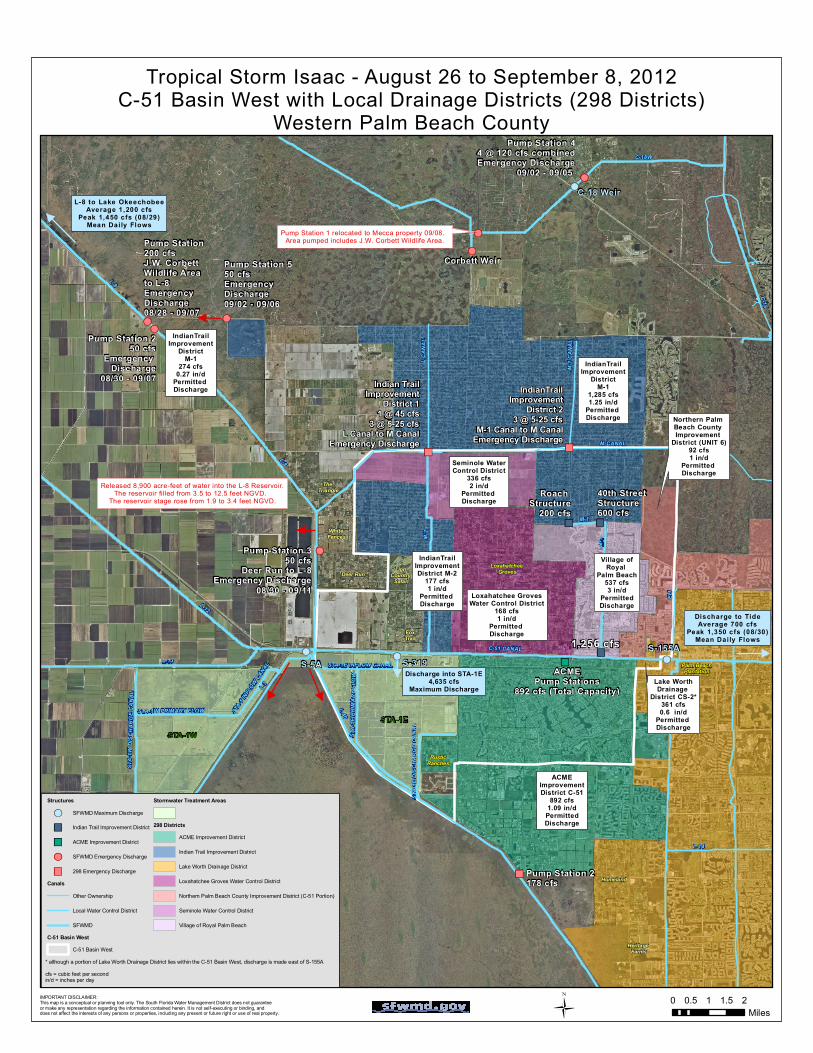
! ( " ) " ) " ) ! ( " ) " ) ! ( ! ( ! ( " ) " ) ! ( ! ( ! ( ! ( ! ( ! ( L-8 L-40 C-51 CANAL L-13 M-2 C-18 M-1 M-CANAL L-12 C-18W STA-1W DISCHARGE CANAL STA-1W PRIMARY FLOW STA-1E PRIMARY FLOW STA-1E INFLOW CANAL STA-1E DISCHARGE CANAL STA-1 INFLOW CANAL E-1 L-14 L-7 M-1 L-8 L CANAL M-1 CANAL Deer Run Fox Trail White Fences Homeland Loxahatchee Groves Heritage Farms Rustic Ranches IndianTrail Improvement District M-1 274 cfs 0.27 in/d Permitted Discharge IndianTrail Improvement District M-2 177 cfs 1 in/d Permitted Discharge Seminole Water Control District 336 cfs 2 in/d Permitted Discharge Loxahatchee Groves Water Control District 168 cfs 1 in/d Permitted Discharge Village of Royal Palm Beach 537 cfs 3 in/d Permitted Discharge ACME Improvement District C-51 892 cfs 1.09 in/d Permitted Discharge Lake Worth Drainage District CS-2* 361 cfs 0.6 in/d Permitted Discharge Northern Palm Beach County Improvement District (UNIT 6) 92 cfs 1 in/d Permitted Discharge Palm Beach Plantation The Triangle Roach Structure 200 cfs 40th Street Structure 600 cfs Discharge into STA-1E 4,635 cfs Maximum Discharge 1,256 cfs S-155A ACME Pump Stations 892 cfs (Total Capacity) Pump Station 2 178 cfs Pump Station 5 50 cfs Emergency Discharge 09/02 - 09/06 Pump Station 2 50 cfs Emergency Discharge 08/30 - 09/07 C-18 Weir Lion Country Safari IndianTrail Improvement District M-1 1,285 cfs 1.25 in/d Permitted Discharge Indian Trail Improvement District 1 1 @ 45 cfs 3 @ 5-25 cfs L Canal to M Canal Emergency Discharge IndianTrail Improvement District 2 3 @ 5-25 cfs M-1 Canal to M Canal Emergency Discharge Pump Station 1 relocated to Mecca property 09/08. Area pumped includes J.W. Corbett Wildlife Area. Pump Station 3 50 cfs Deer Run to L-8 Emergency Discharge 08/30 - 09/11 S-5A Released 8,900 acre-feet of water into the L-8 Reservoir. The reservoir filled from 3.5 to 12.5 feet NGVD. The reservoir stage rose from 1.9 to 3.4 feet NGVD. Discharge to Tide Average 700 cfs Peak 1,350 cfs (08/30) Mean Daily Flows L-8 to Lake Okeechobee Average 1,200 cfs Peak 1,450 cfs (08/29) Mean Daily Flows Pump Station 4 4 @ 120 cfs combined Emergency Discharge 09/02 - 09/05 Pump Station 200 cfs J.W. Corbett Wildlife Area to L-8 Emergency Discharge 08/28 - 09/07 Corbett Weir S-319 STA-1W STA-1E Ü Tropical Storm Isaac - August 26 to September 8, 2012 C-51 Basin West with Local Drainage Districts (298 Districts) Western Palm Beach County IMPORTANT DISCLAIMER: This map is a conceptual or planning tool only. The South Florida Water Management District does not guarantee or make any representation regarding the information contained herein. It is not self-executing or binding, and does not affect the interests of any persons or properties, including any present or future right or use of real property. 0 0.5 1 1.5 2 Miles * although a portion of Lake Worth Drainage District lies within the C-51 Basin West, discharge is made east of S-155A cfs = cubic feet per second in/d = inches per day Structures ! ( SFWMD Maximum Discharge " ) Indian Trail Improvement District " ) ACME Improvement District ! ( SFWMD Emergency Discharge " ) 298 Emergency Discharge Canals Other Ownership Local Water Control District SFWMD C-51 Basin West C-51 Basin West Stormwater Treatment Areas 298 Districts ACME Improvement District Indian Trail Improvement District Lake Worth Drainage District Loxahatchee Groves Water Control District Northern Palm Beach County Improvement District (C-51 Portion) Seminole Water Control District Village of Royal Palm Beach
Transcript

!( ")

") ")

!(")

")

!(!(

!(

")")

!(

!(

!(

!(

!(

!(

L-8

L-40

C-51 CANALL-13

M-2

C-18

M-1

M-CANAL

L-12

C-18W

Perim

eter C

anal

BOYNTON CANAL

STA-

1W D

ISCH

ARGE

CAN

AL

STA-1W PRIMARY FLOW

STA-

1E P

RIMA

RY FL

OW

STA-1E INFLOW CANAL

STA-

1E D

ISCHA

RGE

CANA

L

STA-1

INFL

OW CANAL

E-1

L-14

L-7

M-1

L-8

L CAN

AL

M-1 C

ANAL

Deer Run

FoxTrail

White Fences

Homeland

Loxahatchee Groves

Heritage Farms

RusticRanches

IndianTrailImprovement

DistrictM-1

274 cfs0.27 in/d

Permitted Discharge

IndianTrailImprovementDistrict M-2

177 cfs1 in/d

Permitted Discharge

Seminole WaterControl District

336 cfs2 in/d

Permitted Discharge

Loxahatchee GrovesWater Control District

168 cfs1 in/d

Permitted Discharge

Village ofRoyal

Palm Beach537 cfs3 in/d

PermittedDischarge

ACMEImprovementDistrict C-51

892 cfs1.09 in/d

PermittedDischarge

Lake WorthDrainage

District CS-2*361 cfs0.6 in/d

Permitted Discharge

Northern Palm Beach County Improvement

District (UNIT 6)92 cfs1 in/d

Permitted Discharge

Palm BeachPlantation

The Triangle Roach

Structure200 cfs

40th Street Structure600 cfs

Discharge into STA-1E4,635 cfs

Maximum Discharge

1,256 cfs S-155A

ACMEPump Stations

892 cfs (Total Capacity)

Pump Station 2178 cfs

Pump Station 550 cfsEmergency Discharge09/02 - 09/06

Pump Station 250 cfs

Emergency Discharge

08/30 - 09/07

C-18 Weir

Lion Country

Safari

IndianTrailImprovement

DistrictM-1

1,285 cfs1.25 in/d

Permitted Discharge

Indian TrailImprovement

District 11 @ 45 cfs

3 @ 5-25 cfsL Canal to M Canal

Emergency Discharge

IndianTrailImprovement

District 23 @ 5-25 cfs

M-1 Canal to M CanalEmergency Discharge

Pump Station 1 relocated to Mecca property 09/08. Area pumped includes J.W. Corbett Wildlife Area.

Pump Station 350 cfs

Deer Run to L-8Emergency Discharge

08/30 - 09/11

S-5A

Released 8,900 acre-feet of water into the L-8 Reservoir.The reservoir filled from 3.5 to 12.5 feet NGVD.

The reservoir stage rose from 1.9 to 3.4 feet NGVD.

Discharge to TideAverage 700 cfs

Peak 1,350 cfs (08/30)Mean Daily Flows

L-8 to Lake OkeechobeeAverage 1,200 cfs

Peak 1,450 cfs (08/29)Mean Daily Flows

Pump Station 44 @ 120 cfs combinedEmergency Discharge

09/02 - 09/05

Pump Station 200 cfsJ.W. CorbettWildlife Areato L-8Emergency Discharge08/28 - 09/07

Corbett Weir

S-319

STA-1WSTA-1E

Ü

Tropical Storm Isaac - August 26 to September 8, 2012C-51 Basin West with Local Drainage Districts (298 Districts)

Western Palm Beach County

IMPORTANT DISCLAIMER: This map is a conceptual or planning tool only. The South Florida Water Management District does not guarantee or make any representation regarding the information contained herein. It is not self-executing or binding, and does not affect the interests of any persons or properties, including any present or future right or use of real property.

0 0.5 1 1.5 2Miles

* although a portion of Lake Worth Drainage District lies within the C-51 Basin West, discharge is made east of S-155Acfs = cubic feet per secondin/d = inches per day

Structures

!( SFWMD Maximum Discharge

") Indian Trail Improvement District

") ACME Improvement District

!( SFWMD Emergency Discharge

") 298 Emergency DischargeCanals

Other Ownership

Local Water Control District

SFWMDC-51 Basin West

C-51 Basin West

Stormwater Treatment Areas

298 DistrictsACME Improvement District

Indian Trail Improvement District

Lake Worth Drainage District

Loxahatchee Groves Water Control District

Northern Palm Beach County Improvement District (C-51 Portion)

Seminole Water Control District

Village of Royal Palm Beach

Recommended