72
Tropicana Joint Venture Tropicana Gold Project Landscape Assessment December 2008
Tropicana Joint Venture
Tropicana Gold ProjectLandscape Assessment
December 2008
Executive Summary
The Tropicana Joint Venture (TJV) is proposing to develop the Tropicana Gold Project (TGP) on thewestern edge of the Great Victoria Desert in Western Australia. The TJV is an agreement betweenAngloGold Ashanti Australia Ltd (AGAA; 70% stake and Manager) and Independence Group NL (IG;30% stake).
One of the key environmental challenges identified for the project is the issue of ‘improved access tothe region’. Currently, the region surrounding the project area is relatively inaccessible to the generalpublic due to a lack of quality roads and is relatively pristine in comparison to the traditional gold-bearing areas in Western Australia (WA). As the development of the project will necessitate theconstruction of a higher quality road than currently services the area, it is anticipated that this couldlead to an increase in the number of visitors, be they mining related or tourists, to the region.
GHD has been engaged by the TJV to complete a higher level and broader assessment of thelandscape across the TGP area and anticipated impacts to provide input to the development ofbroader environmental management strategies for the project. The aim of the study is to provide anoverview of the attributes of the Great Victoria Desert (GVD) biogeographic region (IBRA), to outlinewhat makes the landscape of the TGP particularly interesting and to identify what broad scaleenvironmental impacts may be anticipated as a result of the development of the TGP.
The study demonstrated that the TGP is located in a region of Western Australia that can beconsidered to be different to the traditional gold mining areas of WA. The study has found that theTGP area comprises a complex and arid ecosystem that has developed over time and may beconsidered to be delicately balanced. Due to the delicate balance of the arid environment, thepotential indirect impact of the project may be felt at a much wider landscape scale than the morediscrete direct impacts associated with a typical mine. At the broader scale, the main impacts thathave been identified are as follows:
• Improved access to the region.
• Fire.
• Ferals.
• Weeds.
• Clearing.
• Fragmenting habitats and severing corridors.
• Waste.
The impact management strategies for the TGP should be developed:
• At the broader landscape level (i.e. beyond the immediate project boundaries).
• To engage a wide variety of stakeholders from government, industry and community groups.

• To recognise the evolutionary and existing ecological processes with respect to the landscapeso that key large scale features of the landscape including long term ecological processes andinteractions are preserved.
• To maintain connectivity between ecosystems and population.
• With an emphasis on maintaining ecological integrity rather than restoration. (The strategiesshould be preventative to limit the disturbance footprint of the project rather than repairdamage caused).
• To be adaptive with respect to data gaps and research priorities and allow fordevelopment/evolution as result of monitoring and feedback.
461/22966/83368 Tropicana ProjectLandscape Assessment
Contents
Executive Summary 2
1. Introduction 6
2. Background Information 6
2.1 Environmental Assessment 6
2.2 Tropicana Gold Project 7
2.3 Study Area 7
2.4 Previous Studies 8
2.5 Summary of Methods 8
2.6 Limitations 9
2.7 Structure of the Report 9
3. The GVD Bioregion 9
3.1 Physical Description 10
3.2 Biological Description 14
3.3 Landuse History 26
4. Attributes of interest 28
4.1 Geology and Landforms 28
4.2 Vast, Remote and Intact 28
4.3 Biodiversity Significance 29
5. Project Development and Potential Impacts 30
5.1 General 30
5.2 Improved Access to the Region 31
5.3 Fire 31
5.4 Ferals 31
5.5 Weeds 31
6. Summary and Recommendations 36
7. References 36
561/22966/83368 Tropicana ProjectLandscape Assessment
Table IndexTable 1: Climate Data for Laverton and Rawlinna (Source:
BoM, 2008) 10Table 2: Vegetation Associations Present within the Study
Area (as described by Beard, 1974) 16Table 3: Number of species in each status class in the GVD
(Source: National Land and Water ResourcesAudit, 2002) 25
Table 4: Description of Potential Landscape Impacts 33
AppendicesFiguresReferral Document
661/22966/83368 Tropicana ProjectLandscape Assessment
1. Introduction
AngloGold Ashanti Australia (AGAA), in joint venture with Independence Gold NL (theTropicana Joint Venture – TJV), is proposing to develop the Tropicana Gold Project (TGP) onthe western edge of the Great Victoria Desert in Western Australia. The TJV is currentlypreparing the pre-feasibility study and Public Environmental Review (PER) documentation forthe project, which is the most significant gold resource project under development in the pastten years in Western Australia. The environmental approvals process for the project has alsobeen initiated at both a state and a federal level.
One of the key environmental challenges for the project that has been identified is the issue of‘improved access to the region’. Currently, the region surrounding the project area is relativelyinaccessible to the general public due to a lack of quality roads and is relatively pristine incomparison to the traditional gold-bearing areas in Western Australia (WA). The developmentof the project will necessitate the construction of a higher quality road than currently servicesthe area. It is possible that this could lead to an increase in the number of visitors to theregion, which in turn could lead to negative environmental outcomes including (but not limitedto):
• Increased pressure on Nature Reserves in the region, which have been instated toprotect biodiversity and conservation values in WA.
• Introduction of invasive species by the general public who may not be educated in thethreats to biodiversity posed by weeds and feral species in the wider region, and whowill not have been educated and inducted into the hygiene and weed managementpractices of staff and contractors of the TJV.
• Increased incidence of anthropogenic fire in the region with associated detrimentaleffects on ecosystem values and threatened flora and fauna.
GHD has been engaged by the TJV to complete a higher level and broader assessment ofthe landscape across the Tropicana project area and anticipated impacts in order to provideinput to the development of broader environmental management strategies for the project.The aim of this study is to provide an overview of the biophysical aspects of the Great VictoriaDesert (GVD) biogeographic region (IBRA) and specifically to outline what makes thelandscape of the Tropicana project area special and what impacts may be anticipated on theenvironment at the broader landscape scale.
2. Background Information
2.1 Environmental AssessmentEnvironmental management has developed since the advent and subsequent development ofthe environmental impact assessment process (EIA) in the 1970s.
The TGP is being developed in a highly sophisticated and robust regulatory system withrespect to the assessment, approval and subsequent management of all environmentalimpacts. At the same time stakeholders and the public at large have become moreknowledgeable and informed in their understanding of mining and other projects and will, as a
761/22966/83368 Tropicana ProjectLandscape Assessment
result, expect and anticipate the TJV to deliver a serious and honest commitment to theenvironmental management of the project and associated impacts.
The TJV has a strong commitment to the responsible management of the environmentalimpacts associated with the development of the Tropicana project and other potentialresources within the tenement package. This is demonstrated by the following:
• ISO 14000 certification of the Exploration Group
• Policies, procedures and IMS in place for good practice management
• Commitment to avoiding impacts where possible
• Commitment to continually improve management practices following availability ofmore detailed information
• Commitment to adopt best practice environmental management
• Commitment to comply with all relevant legislation, policies, etc
2.2 Tropicana Gold ProjectThe TGP is located approximately 330km to the east northeast of Kalgoorlie Boulder, on thewestern edge of the Great Victoria Desert in Western Australia. It is anticipated that the TGPwill be an open cut gold mine with a life of approximately 15 years (AGAA, 2008). The extentof the project area is shown in Figure 1, Appendix A and full details are provided in thereferral document attached in Appendix B. It is anticipated that the project will have a directimpact on and disturb up to 3,940 hectares.
In summary, the TGP will comprise the following major features:
• Anticipated mine life of 15 years.
• A series of open pits producing up to 7Mt/pa of ore and total mining rate of 75Mtpa
• A standard “Carbon in Leach” processing plant and associated tailings storage facility
• Waste Material Landform with batter slopes of 1:4 or 15 deg covering an area of up to1200 hectares.
• Administration and workshop facilities.
• Accommodation camp for 700 persons.
• Airstrip – sealed with supporting infrastructure including fuel storage tanks.
• Access roads– approximately 300km of made all weather roads.
• Water supply area (borefield) with up to 40 production water bores.
• Power plant with power generation capacity of up to 40MW fuelled by diesel, naturalgas solar thermal or liquid natural gas or a combination of these energy sources.
2.3 Study AreaThe study area comprises a broad area of the western portion of the GVD that incorporatesthe footprint of the TGP and the surrounding broader area encompassing the TJV tenementpackage, proposed infrastructure corridors and potential borefield sites. The total area of thestudy area is 61,924 km2.
The extent of the study area is shown in Figure 1, Appendix A and is broadly defined by thefollowing geographic features and boundaries:
861/22966/83368 Tropicana ProjectLandscape Assessment
• To the south by the Trans-Australian railway.
• To the east by the Tropicana to Transline Infrastructure Corridor (an old sandalwoodlogging track), the western boundary of the Nullarbor region (as defined by the InterimBiogeographic Regionalisation for Australia system) and the Connie Sue Hwy (toNeale Junction).
• To the north by White Cliffs Yamarna Rd and the Anne Beadell Highway.
• To the west by the western limits or boundary of the Great Victoria Desert (GVD).
2.4 Previous StudiesExamination of available literature and information on the project and adjacent areas duringthe desktop study phase indicated that few studies have been completed in the area. Alimited number of broad biological and geological studies have been conducted in the regionsuch as Beard’s vegetation survey (1974) and the WA Geological Survey (1970’s); however,few detailed studies were available. As a consequence, the current understanding of theregion in terms of geology, landscape, flora and fauna associations is limited. In the absenceof available information, the TJV is in the process of conducting numerous detailed flora,fauna and heritage studies throughout the TGP area and its surrounds to provide essentialbaseline information to enable informed decisions to be made with regards to minimisingimpacts of the proposed mine.
2.5 Summary of MethodsThe landscape assessment study included both a desktop study and field assessment. Thepurpose of the desktop assessment was to collate baseline data on the site history andnatural attributes of the study area and to identify key factors responsible for shaping theexisting environment and maintaining landscape function. The desktop study was limited to areview and analysis of readily available literature and published mapping information (referSection 7). Given the limited data available on the study area, studies undertaken within thebroader GVD were also reviewed and key findings noted within the report. Whilst thisassessment was undertaken at a high level over broad spatial scales, it is acknowledged thatthe GVD is not uniform and that the EIA detailed studies may reveal differences between thestudy area and the broader GVD.
Formal consultation with external parties was not undertaken as part of this assessment norincluded in the scope of works developed with the TJV.
The field assessment was undertaken by a qualified Environmental Engineer andEnvironmental Scientist from GHD’s Kalgoorlie office during the period 9 – 11 July 2008. Theprimary purpose of the field assessment was to verify the findings of the desktop assessmentand observe and document key landscape features and influences within the study area.
Given the considerable extent of the study area (refer Figure 1, Appendix A) and limited timeavailable for the site visit, field observations were limited to selected sites accessible by 4WDvehicle. Potential access/communication corridors were also traversed by vehicle whilsttravelling to and from the TGP site, thereby providing an opportunity to identify possibleimpacts associated with upgrading potential infrastructure corridors and to comparelandscape features within the study area to adjacent areas.
A review of potential impacts of the TGP on the broader landscape was undertaken followingthe field assessment and the results are documented within this report.
961/22966/83368 Tropicana ProjectLandscape Assessment
2.6 LimitationsThis landscape assessment has been completed with the following limitations:
• No fine scale floristic and fauna data was available for much of the study area at thetime of the assessment.
• No evaluation of project related impacts has been completed for specific species.
• No assessment has been made of the direct impacts of mining at the local scale.
• No assessment has been made of issues and impacts of cultural heritagesignificance.
2.7 Structure of the ReportThe report is structured as follows:
Section 1: Introduction to the report.
Section 2: Provides background information to this report, including an overview of TJV’senvironmental management commitments, a description of the study area, previous studiesconducted within the region, the methodology employed in the study, study limitations and anoutline of the structure of the report.
Section 3: Includes the following:
• A summary of available baseline information on the natural attributes and landusehistory of the study area. As stated previously, studies undertaken within the broaderGVD were also reviewed and inferences made in relation to the study area whereappropriate.
• A review of key factors responsible for shaping and maintaining natural systemswithin the landscape. Key threats to landscape health such as fire, climate, weedsand feral animals are also discussed in relation to key plant and animal communities.
Information provided in Section 3 is based on the premise that it is necessary to firstunderstand the general characteristics and influences on the landscape prior to appreciatingits special features or identifying potential broad-scale impacts associated with the TGP.
Section 4: Highlights the interesting attributes of the GVD bioregion.
Section 5: Identifies potential broad impacts from the TGP and provides suggestions as tohow they may be managed to minimise or mitigate the impact on the broader landscape.
Section 6: Summarises the key observations, findings and recommendations from thestudy.
3. The GVD Bioregion
The study area lies predominately within the GVD bioregion as delineated under the InterimBiogeographic Regionalisation for Australia (IBRA) system. IBRA is a national planningframework in which 85 biogeographic regions have been established to assist in settingreservation targets across the entire Australian landscape. Each bioregion is a geographicallydistinct area of land with common characteristics such as geology, landform patterns,vegetation, fauna and climate.
1061/22966/83368 Tropicana ProjectLandscape Assessment
The GVD bioregion covers an area of some 418,800 sq. kms (ANRA, 2008), extending fromthe Eastern Goldfields in Western Australia across the southern parts of Central Australia tothe Stuart and Gawler Ranges in South Australia.
The GVD bioregion has been further subdivided into six sub-regions under the IBRAframework. The study area is situated in the western portion of the GVD, predominatelystraddling the Great Victoria Desert Shield subregion (GVD1) and the Great Victoria DesertCentral subregion (GVD 2). A small area of the southern portion of the study area extendsinto the Eastern Goldfields subregion of the Coolgardie bioregion (COO3) and the NullarborCentral band subregion (NUL2) of the Nullarbor bioregion (refer Figure 2, Appendix A).
Given that limited data was available for the study area at the time of this assessment, manylandscape attributes and associated influences have been described for the broader GVDregion. The relevance of regional information to the study area is provided throughout thedocument where appropriate.
3.1 Physical Description
3.1.1 Climate
The climate of the GVD is classified as hot, persistently dry desert, according to a modifiedKoëppen climate classification system (BoM 2008). Average annual rainfall within the GVDranges from 150 mm to over 250 mm (Laut, 1977; Newby, 1984). Northern sectors are slightlymore dominated by summer rainfall patterns; however, rainfall across the region is still largelyunpredictable and highly variable from year to year.
Mean maximum summer temperatures range from 32 – 35 oC (World Wildlife, 2008). Diurnalranges are also considerable with winter temperatures commonly falling overnight to below 0oC.
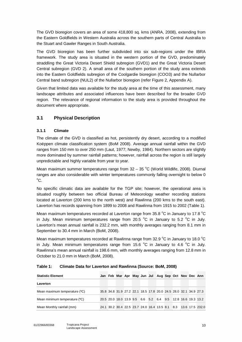
No specific climatic data are available for the TGP site; however, the operational area issituated roughly between two official Bureau of Meteorology weather recording stationslocated at Laverton (200 kms to the north west) and Rawlinna (200 kms to the south east).Laverton has records spanning from 1899 to 2008 and Rawlinna from 1915 to 2002 (Table 1).
Mean maximum temperatures recorded at Laverton range from 35.8 oC in January to 17.8 oCin July. Mean minimum temperatures range from 20.5 oC in January to 5.2 oC in July.Laverton’s mean annual rainfall is 232.2 mm, with monthly averages ranging from 8.1 mm inSeptember to 30.4 mm in March (BoM, 2008).
Mean maximum temperatures recorded at Rawlinna range from 32.9 oC in January to 18.0 oCin July. Mean minimum temperatures range from 15.6 oC in January to 4.6 oC in July.Rawlinna’s mean annual rainfall is 198.6 mm, with monthly averages ranging from 12.8 mm inOctober to 21.0 mm in March (BoM, 2008).
Table 1: Climate Data for Laverton and Rawlinna (Source: BoM, 2008)
Statistic Element Jan Feb Mar Apr May Jun Jul Aug Sep Oct Nov Dec Ann
Laverton
Mean maximum temperature (ºC) 35.8 34.8 31.9 27.2 22.1 18.5 17.8 20.0 24.5 28.0 32.1 34.9 27.3
Mean minimum temperature (ºC) 20.5 20.0 18.0 13.9 9.5 6.6 5.2 6.4 9.5 12.8 16.6 19.3 13.2
Mean Monthly rainfall (mm) 24.1 30.2 30.4 22.5 23.7 24.0 16.4 13.5 8.1 8.3 13.6 17.5 232.0
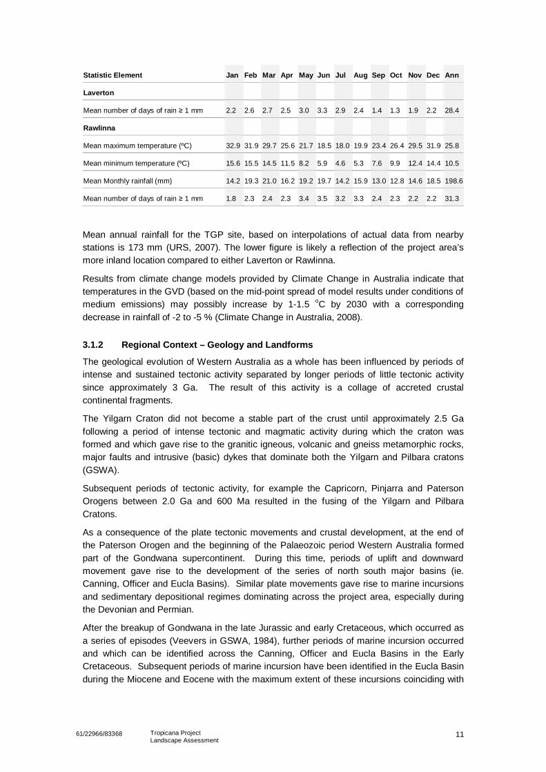
1161/22966/83368 Tropicana ProjectLandscape Assessment
Statistic Element Jan Feb Mar Apr May Jun Jul Aug Sep Oct Nov Dec Ann
Laverton
Mean number of days of rain 1 mm 2.2 2.6 2.7 2.5 3.0 3.3 2.9 2.4 1.4 1.3 1.9 2.2 28.4
Rawlinna
Mean maximum temperature (ºC) 32.9 31.9 29.7 25.6 21.7 18.5 18.0 19.9 23.4 26.4 29.5 31.9 25.8
Mean minimum temperature (ºC) 15.6 15.5 14.5 11.5 8.2 5.9 4.6 5.3 7.6 9.9 12.4 14.4 10.5
Mean Monthly rainfall (mm) 14.2 19.3 21.0 16.2 19.2 19.7 14.2 15.9 13.0 12.8 14.6 18.5 198.6
Mean number of days of rain 1 mm 1.8 2.3 2.4 2.3 3.4 3.5 3.2 3.3 2.4 2.3 2.2 2.2 31.3
Mean annual rainfall for the TGP site, based on interpolations of actual data from nearbystations is 173 mm (URS, 2007). The lower figure is likely a reflection of the project area’smore inland location compared to either Laverton or Rawlinna.
Results from climate change models provided by Climate Change in Australia indicate thattemperatures in the GVD (based on the mid-point spread of model results under conditions ofmedium emissions) may possibly increase by 1-1.5 oC by 2030 with a correspondingdecrease in rainfall of -2 to -5 % (Climate Change in Australia, 2008).
3.1.2 Regional Context – Geology and Landforms
The geological evolution of Western Australia as a whole has been influenced by periods ofintense and sustained tectonic activity separated by longer periods of little tectonic activitysince approximately 3 Ga. The result of this activity is a collage of accreted crustalcontinental fragments.
The Yilgarn Craton did not become a stable part of the crust until approximately 2.5 Gafollowing a period of intense tectonic and magmatic activity during which the craton wasformed and which gave rise to the granitic igneous, volcanic and gneiss metamorphic rocks,major faults and intrusive (basic) dykes that dominate both the Yilgarn and Pilbara cratons(GSWA).
Subsequent periods of tectonic activity, for example the Capricorn, Pinjarra and PatersonOrogens between 2.0 Ga and 600 Ma resulted in the fusing of the Yilgarn and PilbaraCratons.
As a consequence of the plate tectonic movements and crustal development, at the end ofthe Paterson Orogen and the beginning of the Palaeozoic period Western Australia formedpart of the Gondwana supercontinent. During this time, periods of uplift and downwardmovement gave rise to the development of the series of north south major basins (ie.Canning, Officer and Eucla Basins). Similar plate movements gave rise to marine incursionsand sedimentary depositional regimes dominating across the project area, especially duringthe Devonian and Permian.
After the breakup of Gondwana in the late Jurassic and early Cretaceous, which occurred asa series of episodes (Veevers in GSWA, 1984), further periods of marine incursion occurredand which can be identified across the Canning, Officer and Eucla Basins in the EarlyCretaceous. Subsequent periods of marine incursion have been identified in the Eucla Basinduring the Miocene and Eocene with the maximum extent of these incursions coinciding with
1261/22966/83368 Tropicana ProjectLandscape Assessment
the present day 300m and/or 250m contours respectively (Churchill 1973 and Lloyd 1968,both in GSWA).
Throughout its geological history, the region has been and continues to be characterized byhigh levels of weathering the result of which is a regolith (ie. weathered material) with a typicalthickness in excess of 100m. The depth of weathering is typical of geomorphologicalprocesses that operate in humid and moist climates and hence reflects the influence of platetectonics and large scale geological processes on the evolution and development of thecurrent surface geology (and landscape).
The weathering of the underlying rock (refer Section 3.1.3) has given rise to the developmentof three regolith related landform or physiographic units (Anand & Pain, 2002) that arecharacteristic of the the East Yilgarn and Great Victoria Desert region of Western Australia.These are:
• Sediment dominated areas: dominated by fluvial, aeolian and/or lacustrine depositsup to several metres in thickness overlying weathered duricrust or bedrock formingareas of sand plains and sand ridges.
• Ferruginous and siliceous duricrusts: typically formed whilst major drainage systemswere operational but no later than the Late Cretaceous or Early Miocene. Thesedeposits comprise the most common superficial units across Western Australia –laterite and pisolithic gravels (GSWA 1977) and form over older sedimentary andcrystalline rocks.
• Weathered bedrock and colluvial materials: areas of exposed or eroded bedrock thathave not been capped by duricrust and have active areas of colluvial deposition (ie.slope erosion).
3.1.3 Study area context – Geology and Landforms
The TGP is, by way of its geographical location, dominated by two very different groups ofrock whose origins have been described in Section 3.1.2. To the west, the geology isdominated by Archaean and Proterozoic granitic, volcanic and metamorphic rocks which arein excess of 2,500 Ma and form the Yilgarn Craton. To the east the geology is dominated byyounger, sedimentary deposits which unconformably overlie the Archaean and Proterozoicrocks. These younger deposits, which comprise alluvial, lacustrine and aeolian deposits,were laid down in a north south trough which was active from the beginning of the Palaeozoicthrough to the Miocene. The sedimentary material was generated from both the erosion andweathering of the rocks of the Yilgarn Craton and periods of marine incursion and varies inthickness between 600m and 4,300m (Beard 1968).
Whilst the TGP area may be considered to be relatively featureless it comprises undulatingsand plains, dunes with localised breakaways of indurated and siliceous sedimentary rocksand salt lakes (Beard, 1968). The three main physiographic units that can be observed in theTGP area are:
• Sediment dominated areas
This is the dominant landform and soil unit in the project area and reflects the closerelationship with the underlying geology that comprises the older granitic rocks of theYilgarn Craton and younger sedimentary rocks laid down in the Officer, Eucla andCanning Basins (Beard, 1968) from which the sediments have been generated (referSection 3.1.2). These deposits are typically observed in the study and TGP areas.
1361/22966/83368 Tropicana ProjectLandscape Assessment
The aeolian sands that are characteristic of the region form large areas of flatfeatureless plains and longitudinal dunes (GSWA, 1971), which have an averageheight of 10m (typically between 2m and 15m high) and a length that ranges between1.5km to 5km. The dunes vary in width between 100m to 200m and the interduneareas can vary between 250m and 800m in width. The dunes are generallyorientated east west, but localized deviations from this trend indicate that the duneswere formed by westerly winds (King in GSWA, 1971). The origin of the sand thatforms the plains and dunes has been attributed to insitu weathering of the underlyinggranites of the Yilgarn Craton and sedimentary rocks of the Paterson Formation(Beard, 1968).
The dunes and sand plains are considered to be relatively stable or mature. Thismay be determined with respect to the symmetrical shape of the dunes observedacross the project area and the presence of the generally well developed vegetationcover. Photographic studies undertaken in the 1970s by the GSWA indicate thatthere was little or no movement or modification of the dunes in a nine year periodbetween 1961 and 1970 indicating a mature landscape (GSWA, 1971). However, thestudies also indicated that this was found to be the case for both well and sparselyvegetated areas of dune and plain.
The sediment dominated areas also include lacustrine and fluvial silts, clays andhalite deposits and marine silts and clays that correspond to palaeo and existingdrainage regimes that have dominated the area in more recent times, for example theLake Rason system. It should be noted that Lake Rason is a wetland of significance.
• Ferruginous and siliceous duricrusts
• Weathered bedrock and colluvial materials
Localised areas of rock exposure can be seen across the project area, typically alongridge lines and low breakaway features. These areas of exposure are in themselvesthe result of physical and chemical weathering of the weaker kaolinitic zones(Pearson, 1994).
3.1.4 Soils
Limited information is available on the soils that may be encountered across the region andmore specifically in the study and TGP areas. Generally the soils may be described as silty,sandy, loamy soils, generally red to light red brown in colour and of variable thickness.
Limited information is available on the soils that may be encountered in the project area.Recent research by Pearson (1994) of the Queen Victoria Spring Nature Reserve (QVSNR)indicates that the extensive sand plains and dunes have been mapped as red sands withinterdune areas of red earthy sands (Northcote et al 1968). Beard (1974) similarly describedthese soils as friable loams and noted that they occurred between the sands dunes and onbreakaways. He also noted that areas of desert pavement or hamada may be observed thatare strewn with ironstone fine to medium gravels due to wind erosion.
More recently the CSIRO through the ASRIS project has provided further information thatallows the soil type to be related to existing geographical and palaeodrainage features, forexample Lake Rason. The soils vary in fines (clay and silt content) with depth and proximityto these drainage features which has a close bearing on the related vegetation (refer Section6.3). For example to the south of Lake Rason, in the area of and to the south of the proposed
1461/22966/83368 Tropicana ProjectLandscape Assessment
mine area, the landscape is dominated by three vegetation regions as described by Beard(section 3.2.1).
3.1.5 Hydrology
The Lake Rason drainage basin is the dominant regional drainage feature. The regionaldrainage is illustrated in Figure 1. Lake Rason is classified as a wetland with regionalsignificance (Australian Government 2008) and is significant for the maintenance of regionalecological processes. The main lake system occupies an area of some 140 km2, fillsintermittently after rainfall and is saline (Australian Government 2008). It is unlikely that LakeRason ever fills to capacity and overtops. Water ponded in the lake is probably lost toevaporation and seepage.
A Lake Rason drainage line lies some 6 km northeast of the downstream edge of theproposed location of mine infrastructure and the main lake lies some 50 km to the north.
Ponding in Lake Rason and its associated drainage system does not appear to affectdrainage or flooding at the mine site. While the available detailed topographic data does notextend as far as this drainage line, aerial imagery does not indicate a connection between theoverland flow path near the mine and the lake drainage.
Local hydrology has been described in a study undertaken in 2007 by URS Pty Ltd (URS2007). This study focused on defining the catchments that contribute flow to the area of themine site and on quantifying flooding risk for the pit. The hydrologic characterisation given byURS (2007) is summarised here and extended as required to assess impacts of mineinfrastructure on surface water movement and the environment and on pit flood risk.
Infiltration measurements through the mine area have also been provided by the TJV. Theseare summarised here and used to help infer runoff potential for contributing catchments.
The proposed operational area is located in an area with little local hydrologic and catchmentdata and relatively coarse topographic data. Accordingly, the analysis is limited to the extentthat interpretation can be drawn from the available data.
3.2 Biological DescriptionThe following section provides an overview of readily available information on the major plantand vertebrate communities within the study area as well as key factors influencing theirdistribution within the landscape. Identifying key influences and drivers within natural systemsis central to developing effective strategies for minimising impacts from the TGP at broadspatial scales.
3.2.1 Vegetation and Flora
The GVD is remarkably well vegetated and contains a rich mosaic of vegetation communitiesin near pristine condition. Vegetation patterns observed are largely a reflection of thegeological surface, with distinct changes occurring in response to soil structure and landform.Regular fires are also likely to have had a marked influence on vegetation structure.
OriginsA census of Australian vascular plants completed by Hatinuk in 1990, suggests that floristicdiversity recorded within the broader GVD is generally lower than surrounding bioregions,particularly the more mesic areas to the south west (Hatinuk, 1990). It should also be noted,
1561/22966/83368 Tropicana ProjectLandscape Assessment
however, that few fine scale floristic studies have been undertaken within the GVD andrecorded diversity may reflect, in part, differences in survey intensity between regions.
Moore (2005) suggests that lower reported plant diversity in inland arid regions is notsurprising given that speciation takes time and is favoured by adversity rather thancatastrophe. Smith-White (1982) proposes that the cycles of extreme aridity experienced ininland Australia during the Pleistocene era were so severe that they were responsible forrepeated extinctions rather than adaptation and speciation. Surrounding regions such as thesouth west, however, were buffered against such climatic extremes and plants were able tomigrate back and forth as conditions fluctuated with each cycle. This view is supported byPearson (1994) in his analysis of the flora in the QVSNR. Pearson (1994) concluded that thesouth-western flora had a pronounced influence on the composition of the flora of theReserve and was responsible for the comparatively high vascular plant species richnessrecorded (i.e. 198.1 species/1000 km2). The northern extent of this zone of mixed regionalfloras has not been mapped and may extend into the south-west portion of the GVD. Finescale floristic studies are likely to contribute significantly to the current understanding ofrelative plant diversity and the distribution of plant communities within the study area.
Whilst some minor speciation (at specific and intraspecific levels) occurred during thePleistocene, it is likely that the evolutionary development of the arid flora occurred muchearlier and from several biogeographical sources (Smith-White, 1982). Once thought to haveoriginated from outside the continent, it is now accepted that the present day inland flora isderived from plant groups present in more temperate regions of Australia as well as fromplants growing under a variety of conditions in other countries. A more detailed analysis ofthe origin of arid flora is provided in Barker and Greenslade (1982).
PhytogeographyWhilst little fine scale floristic data is available for the GVD region in Western Australia,broader patterns of vegetation assemblages were mapped by Beard as part of the WesternAustralian mapping project conducted from 1964-1981. Beard used a combination of bothstructure and floristics to delineate and describe vegetation associations within botanicaldistricts.
The study area lies predominately within the Helms Botanical District of the GVD. Beard(1980) broadly describes the vegetation within the district as a tree steppe of Eucalyptusgongylocarpa and E. youngiana over Triodia basedowii, with mulga low woodland occurringon hardpan soils between aeolian sand dunes.
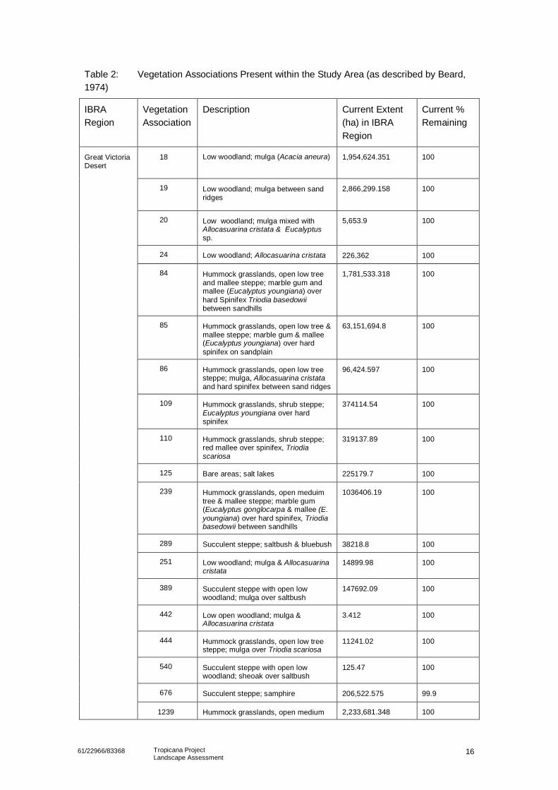
Vegetation communities present within the study area as described and noted by Beard(1974;1980) are listed in Table 2. The regional extent in Western Australia of each vegetation typerepresented and the proportion of each type remaining as a percentage of the pre-European extent (asdrawn from Shepherd, pers.comm., 2005) is also provided. A map of the study area showing Beard’svegetation associations is included in Figure 3, Appendix A.
1661/22966/83368 Tropicana ProjectLandscape Assessment
Table 2: Vegetation Associations Present within the Study Area (as described by Beard,1974)
IBRARegion
VegetationAssociation
Description Current Extent(ha) in IBRARegion
Current %Remaining
18 Low woodland; mulga (Acacia aneura) 1,954,624.351 100
19 Low woodland; mulga between sandridges
2,866,299.158 100
20 Low woodland; mulga mixed withAllocasuarina cristata & Eucalyptussp.
5,653.9 100
24 Low woodland; Allocasuarina cristata 226,362 100
84 Hummock grasslands, open low treeand mallee steppe; marble gum andmallee (Eucalyptus youngiana) overhard Spinifex Triodia basedowiibetween sandhills
1,781,533.318 100
85 Hummock grasslands, open low tree &mallee steppe; marble gum & mallee(Eucalyptus youngiana) over hardspinifex on sandplain
63,151,694.8 100
86 Hummock grasslands, open low treesteppe; mulga, Allocasuarina cristataand hard spinifex between sand ridges
96,424.597 100
109 Hummock grasslands, shrub steppe;Eucalyptus youngiana over hardspinifex
374114.54 100
110 Hummock grasslands, shrub steppe;red mallee over spinifex, Triodiascariosa
319137.89 100
125 Bare areas; salt lakes 225179.7 100
239 Hummock grasslands, open meduimtree & mallee steppe; marble gum(Eucalyptus gonglocarpa & mallee (E.youngiana) over hard spinifex, Triodiabasedowii between sandhills
1036406.19 100
289 Succulent steppe; saltbush & bluebush 38218.8 100
251 Low woodland; mulga & Allocasuarinacristata
14899.98 100
389 Succulent steppe with open lowwoodland; mulga over saltbush
147692.09 100
442 Low open woodland; mulga &Allocasuarina cristata
3.412 100
444 Hummock grasslands, open low treesteppe; mulga over Triodia scariosa
11241.02 100
540 Succulent steppe with open lowwoodland; sheoak over saltbush
125.47 100
676 Succulent steppe; samphire 206,522.575 99.9
Great VictoriaDesert
1239 Hummock grasslands, open medium 2,233,681.348 100
1761/22966/83368 Tropicana ProjectLandscape Assessment
tree and mallee steppe; marble gumand mallee (Eucalyptus youngiana)over hard Spinifex Triodia basedowiion sandplain
1446 Succulent steppe with scrub; mulgaover bluebush
13051.67 100
Nullarbor 441 Succulent steppe with open lowwoodland; mulga & sheoak overbluebush
2335777.3 100
109 Hummock grasslands, shrub steppe;Eucalyptus youngiana over hardspinifex
264906.71 100
467 Mosaic: Medium woodland; salmongum & gimlet / Hummock grasslands,mallee steppe; red mallee overspinifex, Triodia scariosa
278884.1 100
468 Medium woodland; salmon gum &goldfields blackbutt
583361.4 100
Coolgardie
936 Medium woodland; salmon gum 586793.284 100
As indicated in Table 2, each vegetation type present is virtually intact with only a slightreduction in area recorded for the succulent steppe; samphire unit.
Yellow sand plain communities with distinct scrub heath vegetation were observed within thesouthern portion of the study area. The extent and significance of such communities will beapparent following the completion of fine scale floristic and fauna studies. This is potentiallythe recently DEC listed ’Yellow Sand Plain’ Priority Ecological Community (PEC) of the GVD.
Vegetation PatternsAn assessment of the broader influence of edaphic factors on vegetation associations presentwithin the study area was undertaken by GHD by comparing vegetation, soil andgeomorphological mapping for the area.
A comparison of the available information for the project area, obtained from sourcesincluding the GSWA maps, ASRIS maps and Beard vegetation maps, indicates that there is abroad relationship between the underlying geology, resultant soils and vegetation. This isbest illustrated with reference to two areas within the project area as a whole.
Firstly Lake Rason, which is located to the north of the actual mine area, is typified by an areaof saline lacustrine sediments that relate to the current and past (ie. palaeodrainage) drainagehistory of the area. The soils are fine grained and generally comprise in excess of 45% siltsand clays (ASRIS 2008). Vegetation in this area typically comprises salt bush and blue bush.
Secondly to the south of Lake Rason, in the area of and to the south of the proposed minearea, the landscape is dominated by three vegetation associations as described by Beard.These can be differentiated as follows:
• Areas of hummocky grassland with open low trees and mallee, some marble gumsand spinifex. The underlying soil profile comprises loamy, silty and clayey soils withbetween 20% and 30% fines which are in turn underlain by Quaternary colluvial andalluvial deposits (ASRIS 2008 and GSWA 1977).
• Areas of hummocky grassland with open low trees, some marble gums over spinifex.The underlying soil profile comprises sandy loamy soils with less than 10% fines
1861/22966/83368 Tropicana ProjectLandscape Assessment
overlying loamy, silty and clayey soils with between 20% and 30% fines to the base ofthe soil profile. These are in turn underlain by Quaternary aeolian sands with pocketsof colluvial and alluvial deposits (ASRIS 2008 and GSWA 1977).
• Areas of low woodland and mulga. The underlying soil profile comprises sandyloamy soils with less than 10% fines overlying loamy, silty and clayey soils withbetween 20% and 30% fines to the base of the soil profile. These are in turnunderlain by Quaternary aeolian sands with pockets of colluvial and alluvial deposits(ASRIS 2008 and GSWA 1977). This area is dominated by areas of sand plains andsand dunes.
It was observed during the site visit that the broad vegetation associations described aboveare repeated across the project area. These observations support the close relationships thatmay be determined from ASRIS, GSWA and Beard two of which are described above.However whilst broad influences on vegetation associations are apparent at a regional scale,the patchwork of vegetation communities observed in the field over relatively short distancessuggest that more localised factors contribute to patterns of distribution. These are describedin more detail in the following sections.
Influences on Localised Vegetation PatternsFiner scale studies and reviews of landscapes within the GVD (Pearson, 1994; Greenslade etal., 1986; Beard, 1980) provide some insight into factors potentially affecting the distributionand composition of vegetation communities within the project area. It is generally acceptedthat edaphic factors such as landforms, soil structure and chemistry as well as depth tocalcrete or hardpan are the strongest predictors of gross variations observed in vegetationpatterns in the GVD along with external factors such as fire and climate.
It should be noted that subtle changes in edaphic factors can have pronounced effects onpatterns of distribution and often it is the combination of a number of factors that determinesthe composition of vegetation present.
Although a thorough investigation of the above was beyond the scope of this study, fine scalefloristic studies have recently been undertaken within the project area and it is likely thatlocalised factors affecting patterns of distribution will be far more apparent following a detailedanalysis of the data. Some key observations noted during the field visit conducted in earlyJuly 2008 which serve to illustrate the influence of edaphic factors on vegetation patterns areprovided below.
Landforms
Consistent patterns of vegetation distribution were evident in the dune-interdune sequencewithin the project area. The less sandy soils of the dune swales were commonly vegetatedwith mallees and mulga (Acacia aneura) over spinifex. Marble gums (Eucalyptusgonglyocarpa) and mixed shrubs occupied the deeper sandy soils of the dune slopes, withoccasional pockets of Callitris sp. present. Vegetation cover on the crest of the dunes wastypically sparse and consisted of low shrubs. Spinifex was less abundant on the dunes.Greenslade et al. (1982) reported a similar pattern of distribution in GVD dune systems in theUnamed Conservation Reserve (UCR) in South Australia whereby a Eucalyptus gonglyocarpaopen woodland dune community was commonly interspersed with an Acacia aneuraassociation in the swales.
Whilst dune-interdune vegetation associations in the GVD are reasonably well documented,studies investigating causal relationships are relatively scarce. Pearson (1994) found that thesoils on the crests of sand dunes in the Queen Victoria Springs Nature Reserve (QVSNR)
1961/22966/83368 Tropicana ProjectLandscape Assessment
were particularly nutrient poor and suggested that the distinctive flora present was able tobetter cope with severe conditions or able to thrive because of the absence of a well-developed cover of spinifex.
Soils
The vegetation of the sand plains was far less uniform than that of the dunes; however,changes in response to soil conditions were clearly evident. The open woodland ofEucalyptus gonglyocarpa over Triodia basedowi was typically observed on the deeper sandysoils of the plains, whilst mulga groves tended to dominate the finer textured soils (and areasof weathered laterite, duricrust and hamada observed at site). The vegetation association onyellow sand plains was particularly distinctive with a relatively rich scrub heath communitydominant and a noticeable absence of taller shrubs and trees. Pearson (1994) noted thatsimilar substrates in the QVSVR were not only the sandiest, but also the most nutrient poor,with low concentrations of phosphate, nitrogen, potassium and exchangeable cationsrecorded. Whilst allowing rapid infiltration, the relatively coarse sands also exhibit poor waterholding capacity. Such harsh conditions are likely to have favoured the sclerophyll scrubspecies over the taller strata commonly observed in other sand plain communities.
Depth to Hardpan
The presence of a hardpan was also observed by GHD to influence vegetation present in thestudy area. The most noticeable indicator being the regular appearance of Casuarina sp. inareas characterised by shallow soils over a calcareous hardpan. Casuarinas were alsoobserved along valley lines within the project area, possibly reflecting the presence ofhardpan formed from the deposition of calcium carbonate along palaeodrainage channels inearlier times.
The observations made at site support Williams (in Greenslade et al., 1982) who noted thatthe distribution and depth of calcrete and carbonate hardpans in the UCR was just asinfluential in determining patterns of vegetation distribution as the dune-interdune sequence.
Other landform features such as salt lakes and breakaways have distinct vegetationassemblages and edaphic factors influencing vegetation are discussed in Beard’s explanatorynotes of the Great Victoria Desert (1974).
Fire
Fire is a natural feature of the Western Australian Landscape. It was apparent from a limitedreview of MODIS fire data for the 2007 calendar year (Geosciences Australia, 2008) thatnumerous fires occurred within the vicinity of the project area over the 12-month period. Suchfires are difficult to control due to access difficulties and the large extent burnt. Unfortunately,MODIS data does not provide information on fire intensity or extent. Therefore, it is necessaryto refer to detailed analyses of satellite imagery conducted by others in the region. Pianka(2000) undertook a detailed study of fire history in the region (immediately north of the TGParea) by analysing satellite imagery (Landsat) spanning the years 1972-1991. He concludedthat between 2 and 5 % of the landscape was burnt each year and that the average size ofeach fire was approximately 28 km2. Pianka noted, however, that this figure was skewed by afew large fires and concluded that most fires in the region are of intermediate size. Theaverage fire return interval was estimated to be at least 20 years. This relatively long firereturn interval is most probably due to low precipitation rates within the region.
Observations of fire scars within the project area suggest that local fire frequencies andextents may be higher than that reported by Pianka; however, detailed analysis of satellite
2061/22966/83368 Tropicana ProjectLandscape Assessment
imagery data would be required to assess this further. It is also worth noting that most firesare started by lightning and reasons for a possible higher incidence of fires within the projectarea are not immediately apparent. A review of lighting flashes in Western Australia suggeststhat between one and two lightning strikes per square kilometre hit the ground annually withinthe GVD. The proportion of fires in the landscape started by humans is unknown.
The impact of fires on vegetation communities present in the project area is dependent on anumber of factors including fire intensity (severity), extent (area), seasonality (time of year),species composition, and importantly, the time since the last fire (ie. fire interval). Fireregimes which are beyond the tolerance levels of a particular species may result in thedecline and eventual loss of fire sensitive species from the area. For example, an obligateseeder must reach sexual maturity and build up sufficient seed stores in the underlyingsubstrate to have a reasonable chance of recovery if killed by fire. Fires can also exacerbateadditional threatening processes such as soil erosion and weed invasion. Very intense fireswhich kill mature vegetation can contribute to long-term ecological change by removing adultsand leaving new seedlings vulnerable to climate stressors such as drought (WesternAustralian Government, 2008). Exclusion of fire can also impact on biodiversity by limitingreproduction mechanisms of some plants that use ash, smoke or intense heat to germinateseed.
Knowledge of fire ecology and the vulnerability of the community as a whole is of obviousmanagement significance. A key finding from the State of the Environment Report (2007) wasthat appropriate regimes for biodiversity conservation are not well understood, indicating theneed for further investigations and improved management.
Climate
Apart from northern sectors being slightly more dominated by summer rainfall patterns,climate within the study area and GVD is relatively uniform. The influence of climate onvegetation patterns in the GVD is perhaps more appreciable by examining the indirect impactassociated with higher fire frequencies following periods of sustained rainfall. Fuel loadsincrease substantially following significant rainfall events, particularly with the rapidemergence and subsequent drying out of the herbaceous layer. Vegetation types unlikely tosupport fires during drier times are particularly vulnerable during these subsequent periods.An analysis of over 5000 fires in the southern half of the Northern Territory between 1950 and1984 revealed that cumulative millimetres of precipitation was a useful temporal productivityagainst which to calibrate fires and vulnerability of fire (Griffin et al, 1988). During periods oflow rainfall, fires were also smaller and less frequent.
Periods of sustained rainfall within the study area are likely to result in increased fuel loadsand an elevated fire risk in successive dry periods, both in terms of fire frequency and extent.Appropriate strategies should be implemented in relation to changing risk levels.
The effects of climate change on the landscape are difficult to predict due to the uncertainty offuture climatic conditions and the complex nature of ecological systems. However, changesin climatic factors such as temperature and rainfall may impact on the distribution, lifecycles,physiology and ultimately the survival of individual species. Climate change may alsoindirectly affect species and ecosystems by changing factors such as fire frequency andbehaviour, surface and groundwater, the spread of diseases, etc (DEC, 2008).
2161/22966/83368 Tropicana ProjectLandscape Assessment
Key Vegetation Units and Ecological Drivers
Plant communities are a fundamental element of the landscape. Understanding theecophysiology of key vegetation units within the study area is important when developingstrategies to maintain landscape functioning over broad spatial scales. The following providesand overview of key vegetation units within the study area.
Mulga
Mulga is an integral component of the Australian continent with associated communitiesoccupying approximately 20 percent of the landscape. Such communities occur in areasreceiving a mean annual rainfall of between 200 and 500 mm but are noticeably absent fromsemi-arid regions with a regular summer or winter drought (White, 1994).
Mulga is a long-lived species, which has quite variable morphology, both within and betweenpopulations and individuals. It flowers opportunistically when adequate soil moisture isavailable and takes between 5-15 years (or more) to set seed after fire (Williams, 2002).Germination and growth of mulga is also dependent on rainfall.
Mulga is highly adapted to survive in arid environments. Its deep root system can extractmoisture at depth as surface layers dry out and nitrogen fixing bacteria contained within itsroot nodules can assist in overcoming the low nutrient status of surrounding soils. Phyllodesare designed to minimise water loss, yet maximise water harvesting. The near-verticalarchitecture of mulga branches and stems also promotes efficient channelling of rainfall tostem bases (Slayter, 1965).
Mulga also commonly occurs in groves whereby leaf fall (litter) is concentrated and water andnutrients from surface flows are trapped. The litter layer not only provides for effectiverecycling of nutrients but also a fertile bed for future seedling establishment.
Anderson and Hodgkinson (1997) found that the capture of surface flows can be important formulga survival and recruitment, particularly when mulga roots are confined within a shallowsoil zone. (Mulga roots were unable to penetrate and draw water from the fractured rock atdepth and relied on shallow root systems to obtain water). Observations and discussions withthe Tropicana Project team (Bastow pers. comm., 2008) suggest that surface flows within theproject area are minimal and may only occur for brief periods following high intensity rainfallevents. It is therefore considered unlikely that mulga populations in the project area are asreliant on surface water flows as those studied by Anderson and Hodgkinson (1997).Nonetheless, some evidence of nutrient capture from surface flows was evident during thefield visit and disruption to any significant surface flows should be avoided.
Fire regimes can have a significant impact on mulga communities. Mulga is usually killed if itscanopy is burnt. If a second fire occurs before it has had time to set seed or the post fireconditions are not suitable for regeneration, then it can potentially be eliminated from an area.Williams (2002) suggests that fire intervals of less than 10-15 years may cause thecontraction or loss of mulga and reported that mulga systems in some parts of the central andwestern part of its range appear to have contracted in response to fire. Post fire grazing ofemerging seedlings by domestic stock or other exotic species may adversely affectrecruitment.
The occurrence of unplanned fires in mulga landscapes is strongly linked to periods ofprolonged high rainfall and the high fuel levels that result. Williams (2002) suggests that thetraditional patch burning of Spinifex around mulga by Aboriginal people probably helpedprotect mulga from the impacts from wildfires.
2261/22966/83368 Tropicana ProjectLandscape Assessment
Mulga is a key component of the study area, represented in ten of the 24 vegetationassociations present (refer Table 2). Clearly, the long-term survival of mulga within the studyarea is dependent on maintaining hydrological and nutrient balances as well as appropriatefire regimes.
Mallee
Mallee is a collective term for eucalypt species with multiple stems arising from a commonlignotuber. Mallee dominated communities are widespread in the GVD and may occur inassociation with marble gum open woodlands or as belts of tall shrubland, often comprising asuite of different mallee species. Mallee is also dominant within the study area and is a keycomponent in six of the 24 vegetation associations recorded for the area (refer Table 2).
Species in which lignotubers are persistent are most commonly found where the genus isclose to its physiological limits and site qualities are particularly poor (White, 1994). Theprevalence of mallees in the project area is likely to be a reflection of the nutrient poor soils,past fire regimes and climatic conditions of the GVD.
Vegetative growth of mallees occurs in late spring or summer, although this is the hottest timeof the year. While they can flower at most times in response to rain, the major floweringoccurs in summer. Often flowering of co-existing species is staggered so that hybridisation forcompatible species is reduced (White, 1994). Competition for pollinators is also reduced byflowering at different times.
Unlike the mulga, mallees are remarkably tolerant to fire and resprout vigorously after a burn.Mallees also release a large amount of seed following fire and seeds remain in the soil untilsufficient moisture is available to initiate germination. Seedlings can persist in an ‘advancedgrowth’ seedling state until gaps appear in the plant cover and they have room to develop(White, 1994).
Although mallee recruitment may be favoured by fire, it should be noted that adults can bekilled under annual or biennial burning regimes – particularly in autumn (Myers et al., 2004)
Spinifex Grasslands
Spinifex grasslands, characterised by the dominance of perennial hummock grasses of thegenus Triodia, cover around 43 percent of the Western Australian landscape and occurpredominately within the semi-arid/arid interior. Triodia basedowi is the dominant species inthe GVD and is reported to comprise up to 98 percent of recorded plant cover. Plantstypically grow from the centre out, forming a distinctive ring as the centre dies. The rootsystem of mature hummocks is extensive and deep. Many fauna species present in the GVDand study area are also dependent on spinifex communities (Pianka, 1996; Pearson, 1995).
Spinifex grasslands are highly flammable. Hummocks are comprised of dry grass filled withflammable resins and as Triodia clumps grow the gaps between hummocks reduces and theprobability that a fire will spread increases. Winkworth (1967) suggested that all spinifexcommunities in the Northern Territory are in a state of cyclic development from fire to fire, withonly 20 percent in a ‘mature’ climax state. He found that Spinifex roots survive fire andregrowth can be rapid following rain. Spinifex fills in the gaps both vegetatively and by settingseed and this rapid rate of vegetative recovery ensures a high level of fire activity. Fire returnintervals have been suggested to be as low as 3-10 years (Kimber, 1983). Pianka (2000)suggests that fire return intervals in the GVD are probably much longer due to lower rates ofprecipitation and added that a spinifex grassland in the GVD can take as long as 20-25 yearsto reach maturity.
2361/22966/83368 Tropicana ProjectLandscape Assessment
Fire regimes in much of the spinifex grasslands have changed with the cessation of aboriginalburning from a fine grain mosaic of burnt patches at different seral states to a coarse grain,simplified mosaic of infrequent large wildfires (Burrows, 2006). Burrows suggests thatcoupled with predation by introduced predators, changed fire regimes have probablycontributed to the alarming decline in native fauna, particularly medium sized animals andsome ground nesting birds.
Weeds
Large numbers of introduced plants are now established weeds in the Australian landscape.Many species are fast growing and can out-compete native plants for space, light, water andnutrients (CRC, 2008). Fauna habitats can also be impacted and degradation of naturalsystems can occur incrementally over large spatial scales. Weeds can also cause indirectimpacts such as changed fire regimes.
A total of 53 weed species have the potential to occur within the GVD (Thorpe, 2008). Studiescompleted as part of the TGP baseline assessment have only recorded four weed speciespresent within the TGP area. Low recorded weeds levels are considered to be a reflection oflimited dispersal opportunities (e.g. human, vehicle movements, etc), limited disturbance (i.e.relatively intact bushland in good condition) and current weed management practicesemployed by mining companies.
3.2.2 Vertebrate Fauna
AvifaunaMost bird species in the GVD are of Eyrean origin (comparatively young fauna of Australia’sarid inland) and are widespread across the region. Distribution is closely linked to habitattype, with the mallee belt of the GVD providing an active corridor for many mallee inhabitingspecies across southern Australia (Shepard, 1995). The western and eastern populations ofsuch species show little divergence as a result.
Studies of avifauna in the GVD at Mamungari Conservation Park in South Australia indicatethat mulga and mallee habitats generally support a higher diversity and abundance of birdspecies compared to marble gum woodlands (Greenslade et al., 1986). That said, diversity inmarble gum communities increases at different times of the year (e.g. flowering) and largehollow limbs of mature individuals provide ideal nesting and roosting sites. The chenopodshrublands also support a different suite of species, adding to overall diversity across theregion. Habitat preferences for a range of selected species within the GVD are provided inShepard (1995).
Abundance and distribution of avian communities is also linked to availability of food andwater. The most obvious example being the marked increase in nectivorous species observedacross habitat types during peak flowering periods. Given that rainfall is limited andunpredictable in the GVD, species are either highly nomadic or have evolved strategies tosurvive in arid environments
A useful summary of the status of avifauna in the GVD is provided in the TerrestrialAssessment 2002 report (National Land and Water Resources Audit, 2002). Key findings arelisted below:
• Species diversity recorded for the GVD during assessment surveys (178 species)was generally lower than most IBRA regions.
2461/22966/83368 Tropicana ProjectLandscape Assessment
• The GVD has the highest level of Australian endemism (i.e. Australian endemicspecies/total resident species).
• A handful of limited range, threatened and introduced species are reported to occur inthe region, but only in limited numbers.
• Potential exists for the decline of some ground feeding birds as a result of grazing,predators and/or changes in fire regimes.
A number of additional bird surveys have been undertaken in the GVD (Burbidge et al.,1976;Greenslade et al., 1982); however, the extent of the region surveyed is still somewhat limitedand reported trends must be treated with caution. Baseline surveys of the project areacommissioned by AGAA will add significantly to existing data and it is expected that ongoingmonitoring will assist in determining localised trends.
ReptilesThe GVD supports an exceedingly high diversity of reptiles and comprises one of the mostdiverse lizard faunas on earth (Panika, 1996). More than 100 species of reptiles have beenrecorded in the GVD region and up to 53 lizard species have being found to coexist on asingle sand ridge site, located not more than 70 kms north east of the study area (Pianka,1996). It is reasonable to assume that similar sites (i.e. stable sandridges) within the studyarea would support comparable reptile diversity. By way of comparison, American desertshost a mere dozen species of lizards.
Extensive lizard radiations and speciation occurred all over the arid interior of Australia,largely in response to climatic changes in the late Pleistocene and the associated shifting andisolation of vegetation patches. Unsuitable habitats are considered to have limited dispersaland contributed to isolation rather than any obvious geographical barriers. Natural wildfiresare also likely to have fostered local diversity. Pianka (2000) suggests that natural wildfirescreate a patchwork of habitats in various states of recovery and that each favours a differentsubset of species.
Whilst some lizard species are ubiquitous across the arid interior, many have developed ahigh degree of habitat specificity. Habitat requirements and influences on distribution ofselected species are provided in Shepard (1995).
MammalsFifty-two mammal species have been recorded within the GVD which represents a moderatelevel of relative mammal species richness within Australia. The total number of mammalspecies recorded within IBRA regions ranges from 25 to 86 species. A summary of thecurrent mammal status within the region (as reported in the National Land and WaterResources Audit Report, 2002) is provided in Table 3.
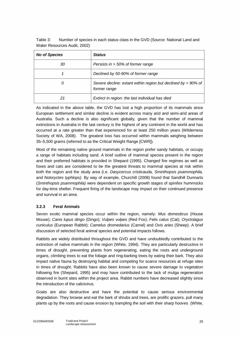
2561/22966/83368 Tropicana ProjectLandscape Assessment
Table 3: Number of species in each status class in the GVD (Source: National Land andWater Resources Audit, 2002)
No of Species Status
30 Persists in > 50% of former range
1 Declined by 50-90% of former range
0 Severe decline: extant within region but declined by > 90% offormer range
21 Extinct in region: the last individual has died
As indicated in the above table, the GVD has lost a high proportion of its mammals sinceEuropean settlement and similar decline is evident across many arid and semi-arid areas ofAustralia. Such a decline is also significant globally, given that the number of mammalextinctions in Australia in the last century is the highest of any continent in the world and hasoccurred at a rate greater than that experienced for at least 250 million years (WildernessSociety of WA, 2008). The greatest loss has occurred within mammals weighing between35–5,500 grams (referred to as the Critical Weight Range [CWR]).
Most of the remaining native ground mammals in the region prefer sandy habitats, or occupya range of habitats including sand. A brief outline of mammal species present in the regionand their preferred habitats is provided in Shepard (1995). Changed fire regimes as well asfoxes and cats are considered to be the greatest threats to mammal species at risk withinboth the region and the study area (i.e. Dasycercus cristicauda, Sminthopsis psammophila,and Notoryctes typhlops). By way of example, Churchill (2008) found that Sandhill Dunnarts(Sminthopsis psammophila) were dependent on specific growth stages of spinifex hummocksfor day-time shelter. Frequent firing of the landscape may impact on their continued presenceand survival in an area.
3.2.3 Feral Animals
Seven exotic mammal species occur within the region, namely: Mus domesticus (HouseMouse); Canis lupus dingo (Dingo); Vulpes vulpes (Red Fox); Felis catus (Cat); Oryctolaguscuniculus (European Rabbit); Camelus dromedarius (Camel) and Ovis aries (Sheep). A briefdiscussion of selected feral animal species and potential impacts follows.
Rabbits are widely distributed throughout the GVD and have undoubtedly contributed to theextinction of native mammals in the region (White, 1994). They are particularly destructive intimes of drought, preventing plants from regenerating, eating the roots and undergroundorgans, climbing trees to eat the foliage and ring-barking trees by eating their bark. They alsoimpact native fauna by destroying habitat and competing for scarce resources at refuge sitesin times of drought. Rabbits have also been known to cause severe damage to vegetationfollowing fire (Shepard, 1995) and may have contributed to the lack of mulga regenerationobserved in burnt sites within the project area. Rabbit numbers have decreased slightly sincethe introduction of the calicivirus.
Goats are also destructive and have the potential to cause serious environmentaldegradation. They browse and eat the bark of shrubs and trees, are prolific grazers, pull manyplants up by the roots and cause erosion by trampling the soil with their sharp hooves (White,
2661/22966/83368 Tropicana ProjectLandscape Assessment
1994). Goats are not known to occur within the project area; however, the potential exist forpopulations to expand beyond their current distribution if suitable watering points are created.
Camels are widely distributed within the GVD and grazing has been shown to negativelyimpact on vegetation (Peeters et al., 2005). Shepard (1995) also suggests that the capacity ofcamels to drink waterholes dry can cause serious environmental impacts. Such impacts arelikely to increase if camel densities continue to rise. Densities in the Northern Territory arepredicted to increase by 10% per year and approximately double every eight years (Edwardset al, 2004). A report on Plumridge Lakes prepared by the non-profit organisation, DesertDiscovery, suggests that camel numbers in the GVD may be as high as 700,000 (noreference was provided for this figure). It is worth noting that the lack of artificial wateringpoints in the GVD may limit the abundance and distribution of camels in times of drought(Peeters et al., 2005).
Feral cats are abundant throughout the GVD. There lack of dependence on free water fordrinking, their omnivorous diet and their capacity to breed prolifically has allowed them tosurvive and flourish in the arid environment. Whilst rabbits are the primary food source forferal cats, native mammal populations are likely to have suffered dramatic declines asalternative food sources were found in times of drought. Shepard (1995) notes that many ofthe native mammals now extinct are within the size range of prey preferred by feral cats.
The red fox has a similar distribution across Australia to the rabbit and can be foundthroughout the GVD. Like the feral cat it will seek out native fauna when rabbits are scarce.Cats and foxes are considered to be key threats to most faunal species at risk within theGVD.
3.3 Landuse HistoryThe landuse history of the GVD, and adjacent areas, can be divided into four main periodswhich are:
• Pre 1857: Traditional Aboriginal life prior to European contact.
• 1857 to 1932: European exploration.
• 1932 to 1970: European development.
• 1970 to present day: Recent times.
The following summary of the landuse history is provided for completeness and draws heavilyon the work completed by Mark Shepherd in his book The Great Victoria Desert: north of theNullarbor, south of the Centre (1995) and work completed by the Commonwealth Government.
3.3.1 Traditional Aboriginal life prior to European contact
The Australian continent has been inhabited by Aboriginal people for approximately 50,000years. In the GVD traditional life revolved around small groups using hunter gatherertechniques to survive. Water determined how successful the use of these techniques (ie.hunting) would be and the availability of foods from traditional plant sources. As a resultthese groups were extremely mobile, highly flexible and adaptive due to their dependence onthe limited sources of water throughout the area.
To survive the harsh conditions that prevailed throughout the GVD, periods of low rainfall andeven drought, the Aboriginal people employed water conservation measures such as
2761/22966/83368 Tropicana ProjectLandscape Assessment
construction of dams on clay pans, the use of harvesting water from the roots of certain treesand covering rock holes to reduce evaporation.
3.3.2 European Exploration: 1857 to 1932
Following on from the arrival of Europeans in Australia, the seventy five years between 1857and 1932 were dominated by the exploration of the region by Europeans whose aspirationsand goals were to explore the large uncharted block of land to the west of the OverlandTelegraph line and to establish the first land link with the western coast. This would only bepossible and achieved by finding permanent supplies of good water and lands that could bedeveloped to support communities across this new region of Australia.
Exploration occurred from both directions: from east to west by the likes of Giles (1873) andForrest (1874) and from west to east by the likes of Mason (1896) and Russel (1897). One ofthe main impacts of these ventures was the increased contact with the traditional people thatlived across the region and the beginning of the influence of Europeans on their lifestyles.
3.3.3 The Contact Years: 1932 to 1970s
This period of land tenure was dominated by a series of major events including:
• WWII
• Construction of the Transaccess railway and numerous access tracks across theregion.
• Establishment of Missions at places such as Cunderlee, Mount Margaret and CosmoNewberry as part of the government’s policy approach to provide welfare to andassimilate Aboriginal people into the wider Australian community.
• Proclamation of the Woomera Prohibited Area by the Australian and BritishGovernments in 1946. The area was subsequently used for the testing of long rangerockets, major nuclear trials (at Totem and Maralinga) and several hundred smallerscale trails (AVRN, 2008).
3.3.4 Recent times: From 1970 to the present day
The majority of the GVD today is crown land, conservation reserves and Aboriginal land.Since the 1970s Aboriginal people have had the legislative backing to begin and see throughthe process by which they can claim land tenure over their traditional lands and as aconsequence return to these lands to live. As a result a significant portion (majority) of theGVD is under the tenure of four major Aboriginal groups (Shephard, 1995) including theArangu Pitjantjatjara and Maralinga Tjarutja.
Conservation and nature reserves in the GVD include Queen Victoria Spring, PlumridgeLakes and Neales Junction all of which are within or close to the study area and TGP area.
Despite the intense period of exploration from 1857 to 1932, little infrastructure has beenconstructed and the majority of the GVD is still considered inaccessible (AVRN, 2008). As aconsequence large expanses of the region can be considered to be relatively pristine andretain most of the biological integrity.
The region has however been subject to more recent periods of exploration and visitation withthe resultant localised degradation of the region (AVRN, 2008). This has included mineralexploration activity which has been typically undertaken from the Western Australian side of
2861/22966/83368 Tropicana ProjectLandscape Assessment
the GVD from the centres of Kalgoorlie Boulder and Laverton. Examples of such activityinclude:
• PNC: for uranium
• Western Mining: for nickel
• Independence/AngloGold Ashanti: for gold
• Energy and Minerals Australia: for uranium
4. Attributes of interest
The TGP is located in a region of Western Australia that, as the above sections demonstrate,can be considered to be of particular interest. This has been recently recognised by theDepartment of Environment and Conservation which registered the south western portion ofthe GVD as a site of priority ecological conservation (PEC) in August 2008 (DEC, 2008).
The key special attributes of the study area (and the south west of the GVD) are summarisedbelow.
4.1 Geology and LandformsThe study area is dominated by, as described in Section 3.1, the following significantgeological and landform features:
• The study area straddles the north western and western boundary of the marineincursions that occurred during the Miocene and Eocene (ref Section 3.1.2). As aconsequence the surface geology and subsequent landforms are strongly influencedby the underlying bedrock.
• The study area is dominated by two landforms; dunes and sand plains. These havebeen formed by erosion of the underlying igneous and sedimentary bedrock (referSection 3.1.3). The resultant landforms have had a strong influence on thedevelopment of the flora and fauna communities observed across both the study andproject areas.
• Lake Rason is a wetland of know and recorded significance. Located to the north ofthe project area, it is an area of saline lacustrine sediments that relate to the currentand past (ie. palaeodrainage) drainage history of the area. Its significance may beattributed to the close relationship that can be identified between the underlyinggeology and soils and the resultant landforms and vegetation. For example the soilsthat are observed within the Lake Rason area are fine grained and generallycomprise in excess of 45% silts and clays (ASRIS 2008). The presence of these soilshas had a strong controlling influence on the vegetation associations in the area. Inthe area immediately surrounding Lake Rason the vegetation typically comprises saltbush and blue bush.
4.2 Vast, Remote and IntactThe most significant feature of the GVD is that it is vast, remote and intact.
A review of data from the Australian Native Vegetation Assessment 2001 (Cofinas &Creighton, 2001) revealed that the GVD is one the largest intact landscapes left in Australia.

2961/22966/83368 Tropicana ProjectLandscape Assessment
It is also reported to be among the ten largest deserts in the world (World Almanac, 2005),making its considerable expanse significant not only nationally but also on a global level.
Due to its remote location, the GVD has largely escaped European incursions and remains ina relatively undisturbed condition. Impacts resulting from sandalwood harvesting, miningexploration and tourist activity have been limited and, apart from the western fringes whichhave been subjected to clearing and grazing by domestic stock, the condition of thelandscape is good. The GVD also has virtually all of its original vegetation remaining (ANRA,2008). By comparison, only 40% of the pre-European extent of native vegetation still remainsin the South West and only 8.6% remains in the western Avon Wheatbelt subregion (EPA,2007). Connectivity within landscapes is important for maintaining key ecosystem processesand diversity at all levels. Fragmented landscapes may experience a decline in geneticdiversity and ecosystem resilience.
The GVD has also largely escaped the invasion and establishment of weeds which hasoccurred in more accessible and disturbed regions. Only four weed species have beenrecorded in the study area during TGP baseline assessment surveys.
4.3 Biodiversity SignificanceThe GVD is also significant from a biodiversity perspective. As discussed previously (Section3.2.2), it is host to one of the richest lizard faunas in the world with up to 53 species recordedat a single sand ridge site (Pianka, 1996). By way of comparison, American deserts host amere dozen species of lizards. Many factors have contributed to such extraordinary lizarddiversity; however, the most significant appear to be the shifting and isolation of vegetationpatches during the Pleistocene and the mosaic of habitats created by natural wildfires.
Whilst inland arid regions are generally not considered to represent areas of significant plantdiversity, a study by Sattler and Creighton (2002) focusing on combined Acacia and eucalyptdiversity across Australia, found that the GVD is more significant than first thought. Sattlerand Creighton analysed patterns of species richness, endemism and irreplacability for allspecies of Acacia and eucalypt across IBRA regions. (Irreplacability is a measure of thedegree to which species in a region are represented in other regions). The study revealedthat the GVD was significant in terms of not only the number of species present from bothgenera but also the proportion of Acacia and eucalypt species that have restricteddistributions.
The GVD is also considered to be significant in terms of its connectivity at a broaderlandscape level. An example is the ‘Giles Corridor’ which is a narrow strip of Acaciavegetation in the northern sector of the GVD linking Acacia shrubland in the Pilbara to that ofthe central ranges by passing through Lake Carnegie. Such corridors are particularlyimportant for fauna reliant on Acacia shrubland for habitat. (It should be noted, however, thatthe ‘Giles Corridor’ is outside of the study area.) Shepard (1995) suggests that the distinctivemallee belt immediately to the north of the Nullarbor Plain may also form a biological corridorbetween the southern mallee of South Australia and Western Australia.
Given the extent and remoteness of the GVD, only a small portion of the landscape has beensurveyed and it may contain taxa currently unknown to science. Hopper and Gioia (2004)suggest that 10-15 % of Western Australia’s flowering plants are yet to be discovered.Results of fine scale studies recently commissioned by TJV were unavailable at the time ofthis assessment, but should contribute significantly to existing baseline data and provide agreater understanding of biodiversity within the study area and region.
3061/22966/83368 Tropicana ProjectLandscape Assessment
5. Project Development and Potential Impacts
5.1 GeneralThe development of any mining project will result in a variety of impacts on and to thereceiving environment. What is important is how these impacts are first understood andcontextualised then assessed, prioritized and subsequently managed by the proponent of theproject.
The aim of this study has been to identify the processes that have resulted in thedevelopment or formation of the prevailing landscape as it exists today in the study area andmore specifically the project area. By improving the understanding of the ecologicalprocesses that operate at the broader regional scale, which is critical if landscapes are tofunction effectively at a regional level, the impacts of the TGP may be minimised andmanaged effectively.
The assessment has found that the study and project areas comprise a complex and aridecosystem that has developed over time and may be considered to be delicately balanced.Due to the delicate balance of the arid environment, the potential indirect impact of the projectmay be felt at a much wider landscape scale than the more discrete direct impacts associatedwith a typical mine. Indeed the cumulative effect of impacts that may be consideredmanageable in their own right may actually be sufficient to initiate broader scale landscapedegradation.
At a broad scale the main impacts that have been identified are as follows:
• Improved access to the region.
• Fire.
• Ferals.
• Weeds.
• Clearing.
• Fragmenting habitats and severing corridors.
• Waste.
The impact management strategies for the Tropicana project should be developed:
• At the broader landscape level (ie. beyond the immediate project boundaries).
• To engage a wide and relevant group of stakeholders from government, industry andcommunity groups.
• To recognise the evolutionary and existing ecological processes with respect to thelandscape so that key large scale features of the landscape including long termecological processes and interactions are preserved.
• To maintain connectivity between ecosystems and population.
• With an emphasis on maintaining ecological integrity rather than restoration. (Thestrategies should be preventative to limit the disturbance footprint of the project ratherthan repair damage caused).
• To be adaptive with respect to data gaps and research priorities and allow fordevelopment/evolution as result of monitoring and feedback.
3161/22966/83368 Tropicana ProjectLandscape Assessment
5.2 Improved Access to the RegionDevelopment of the TGP will open up the south western portion of the GVD to increasedhuman activity and traffic through the construction of either the Pinjin access road or theTropicana to Transline Infrastructure Corridor, or both.. The increased activity will be relatedto mineral exploration and tourist activity.
The impact is considered more significant following the recent lifting, by the newly electedLiberal State Government, of the ban on uranium mining in Western Australian (The SundayTimes, November 2008). The study area is known to contain three significant deposits ofuranium ore which have been previously explored by NPC and more recently by EnergyAustralia NL (at Mulga Rocks).
Improved access to the region may be considered as the beginning of the impact of the TGP.Subsequent and related impacts are fire, ferals and weeds as described in the followingsections.
5.3 FireThe impact of fire on the vegetation and associated fauna has been described in detailSection 3.2.1. Observations made during the site visit in July 2008 indicated that some of thestudy area has been subject to significant fires in subsequent years (ie. after two years ofburning). The increased frequency of burning has had an impact on the mulga, spinifex andmallee communities which are sensitive to repeat fire events.
Whilst the majority of fires may be attributed to natural causes (lightning), the frequency andproximity and frequency of some of the fires may be the result of human activity. It may beconsidered that increased human activity has and will, have an increasing and moredestructive impact on the landscape. In order to manage the potential impact of fire on theregion, the impact at the community and landscape level should be investigated further.Management strategies should also be flexible to cater for changes in fuel load followingperiods of rain.
5.4 FeralsThe development of the TGP may result in increased feral numbers and activity in the studyand project areas. The Pinjin access road and the Tropicana to Transline InfrastructureCorridor will provide ferals with better access to the area, whilst activity at the TGP andneighbouring sites will provide ferals with more readily available sources of water and food.Similarly, following periods of higher rainfall, feral activity can increase through attraction tothe new vegetation (ie. goats, camels).
Examples of the impacts of increased feral numbers include the displacement of natives andloss of seeds by rabbits.
As the impact of ferals is regional, the management of the issue needs to be effected at aregional level to ensure that the area as a whole is managed.
5.5 WeedsThe information presented in Section 3.2.1 indicates that whilst a total of 53 weed specieshave the potential to occur within the GVD (Thorpe, 2008), only recorded four weed speciesare present within the TGP area. This has been attributed to the current limited dispersalopportunities (e.g. human, vehicle movements, etc), limited disturbance (i.e. relatively intact
3261/22966/83368 Tropicana ProjectLandscape Assessment
bushland in good condition) and current weed management practices employed by miningcompanies.
As for fire and ferals the TGP may, through the improved access to the region, increase thenumber of weeds found in the region due to increased vehicle movements (dispersal),increased frequency of soil movements, increased fire events and due to clearance of areasof native vegetation. It should be noted that weeds are able to invade large areas and can liedormant for many years prior to germinating resulting in an incremental impact on thelandscape.
Table 4 provides a summary of the four impacts described above and other broaderlandscape scale impacts that may be experienced as a result of the development of the TGP.As this study is focused on the broader level of the region and impacts, it is anticipated that amore detailed assessment of the more specific impacts that may be experienced will beaddressed by the full environmental impact assessment (PER) documentation. As a result nocomment on these impacts has been made in this report.
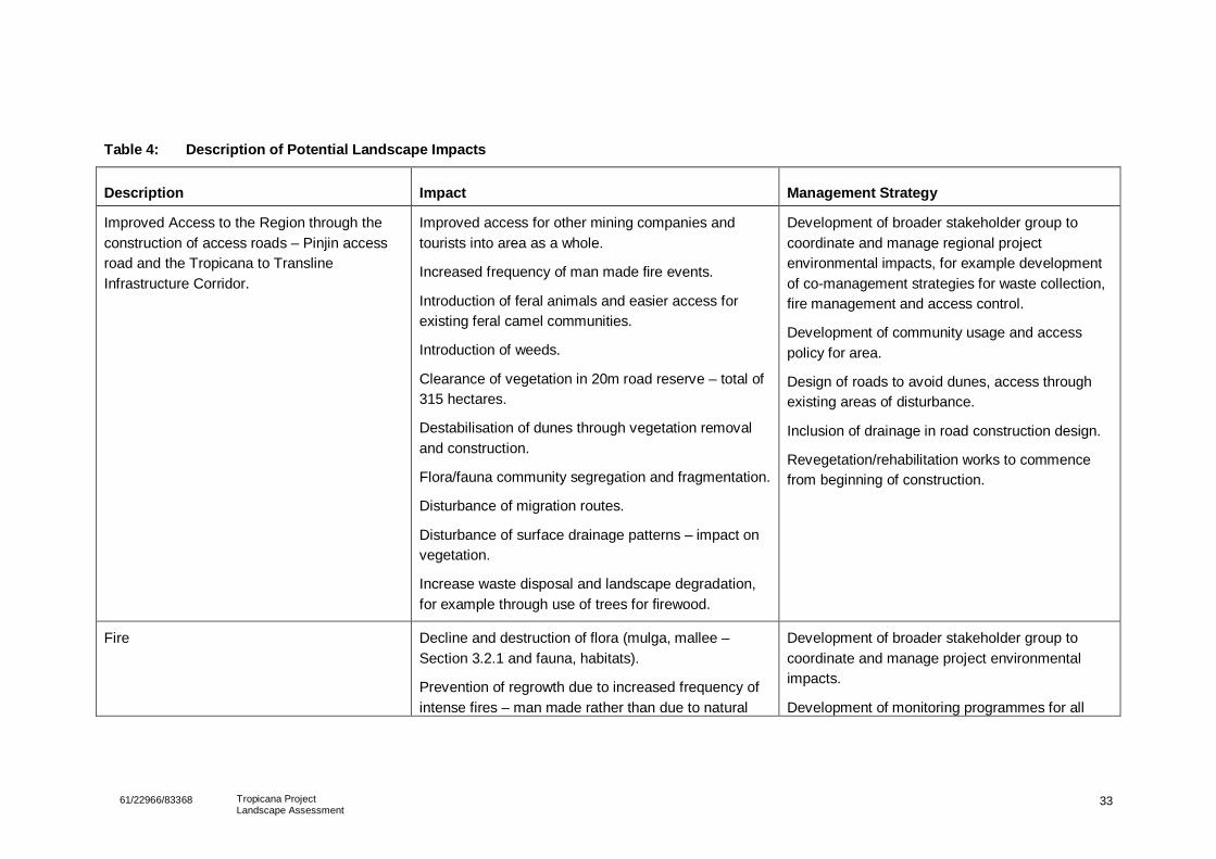
3361/22966/83368 Tropicana ProjectLandscape Assessment
Table 4: Description of Potential Landscape Impacts
Description Impact Management Strategy
Improved Access to the Region through theconstruction of access roads – Pinjin accessroad and the Tropicana to TranslineInfrastructure Corridor.
Improved access for other mining companies andtourists into area as a whole.
Increased frequency of man made fire events.
Introduction of feral animals and easier access forexisting feral camel communities.
Introduction of weeds.
Clearance of vegetation in 20m road reserve – total of315 hectares.
Destabilisation of dunes through vegetation removaland construction.
Flora/fauna community segregation and fragmentation.
Disturbance of migration routes.
Disturbance of surface drainage patterns – impact onvegetation.
Increase waste disposal and landscape degradation,for example through use of trees for firewood.
Development of broader stakeholder group tocoordinate and manage regional projectenvironmental impacts, for example developmentof co-management strategies for waste collection,fire management and access control.
Development of community usage and accesspolicy for area.
Design of roads to avoid dunes, access throughexisting areas of disturbance.
Inclusion of drainage in road construction design.
Revegetation/rehabilitation works to commencefrom beginning of construction.
Fire Decline and destruction of flora (mulga, mallee –Section 3.2.1 and fauna, habitats).
Prevention of regrowth due to increased frequency ofintense fires – man made rather than due to natural
Development of broader stakeholder group tocoordinate and manage project environmentalimpacts.
Development of monitoring programmes for all
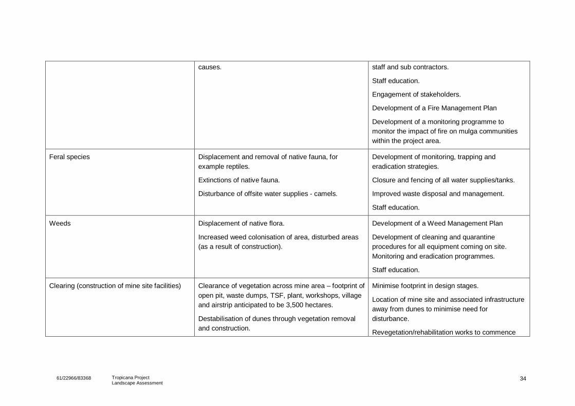
3461/22966/83368 Tropicana ProjectLandscape Assessment
causes. staff and sub contractors.
Staff education.
Engagement of stakeholders.
Development of a Fire Management Plan
Development of a monitoring programme tomonitor the impact of fire on mulga communitieswithin the project area.
Feral species Displacement and removal of native fauna, forexample reptiles.
Extinctions of native fauna.
Disturbance of offsite water supplies - camels.
Development of monitoring, trapping anderadication strategies.
Closure and fencing of all water supplies/tanks.
Improved waste disposal and management.
Staff education.
Weeds Displacement of native flora.
Increased weed colonisation of area, disturbed areas(as a result of construction).
Development of a Weed Management Plan
Development of cleaning and quarantineprocedures for all equipment coming on site.Monitoring and eradication programmes.
Staff education.
Clearing (construction of mine site facilities) Clearance of vegetation across mine area – footprint ofopen pit, waste dumps, TSF, plant, workshops, villageand airstrip anticipated to be 3,500 hectares.
Destabilisation of dunes through vegetation removaland construction.
Minimise footprint in design stages.
Location of mine site and associated infrastructureaway from dunes to minimise need fordisturbance.
Revegetation/rehabilitation works to commence
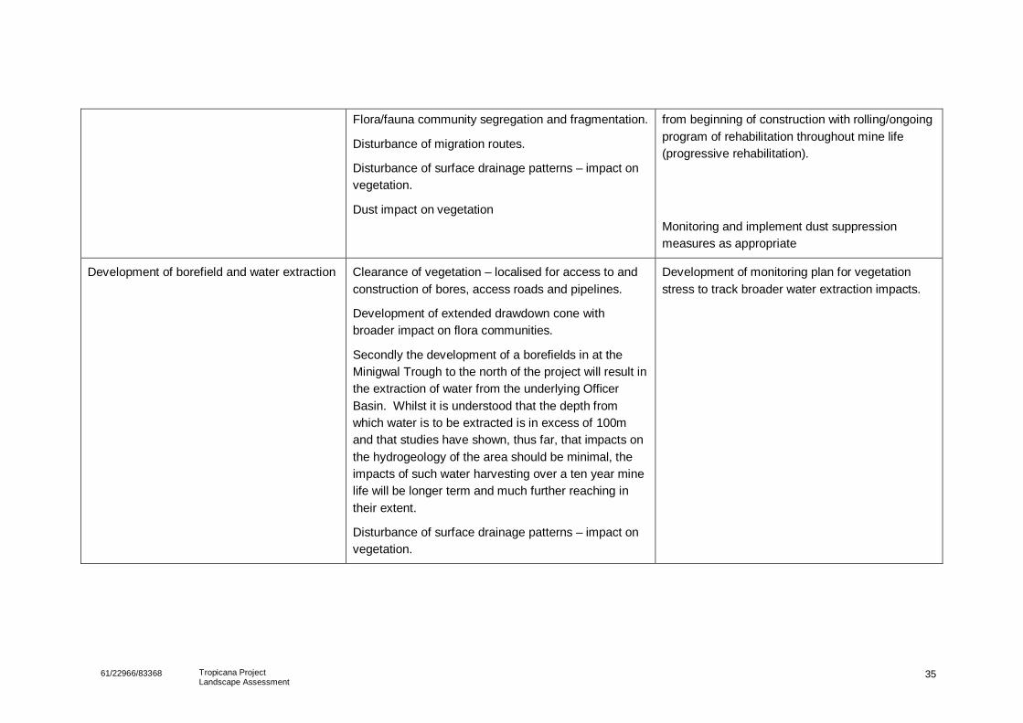
3561/22966/83368 Tropicana ProjectLandscape Assessment
Flora/fauna community segregation and fragmentation.
Disturbance of migration routes.
Disturbance of surface drainage patterns – impact onvegetation.
Dust impact on vegetation
from beginning of construction with rolling/ongoingprogram of rehabilitation throughout mine life(progressive rehabilitation).
Monitoring and implement dust suppressionmeasures as appropriate
Development of borefield and water extraction Clearance of vegetation – localised for access to andconstruction of bores, access roads and pipelines.
Development of extended drawdown cone withbroader impact on flora communities.
Secondly the development of a borefields in at theMinigwal Trough to the north of the project will result inthe extraction of water from the underlying OfficerBasin. Whilst it is understood that the depth fromwhich water is to be extracted is in excess of 100mand that studies have shown, thus far, that impacts onthe hydrogeology of the area should be minimal, theimpacts of such water harvesting over a ten year minelife will be longer term and much further reaching intheir extent.
Disturbance of surface drainage patterns – impact onvegetation.
Development of monitoring plan for vegetationstress to track broader water extraction impacts.
3661/22966/83368 Tropicana Gold ProjectLandscape Assessment
6. Summary and Recommendations
The TJV is proposing to develop the Tropicana Gold Project (TGP). The project is located in an area ofWestern Australia that has been subject to a limited number of studies and investigations since the early1970s. Whilst these have been typically associated with earlier exploration work completed bycompanies such as Western Mining Corporation (WMC), the focus of these studies has been on theimmediate management of discrete impacts.
This study has demonstrated that the TGP is located in an area of the Western Australian landscape thatis considered to be of particular interest. The study has shown that many characteristics of the regioncan be related to the underlying geology, soils and landforms, all of which have had an influence on thedevelopment of the landscape, vegetation and fauna communities that can be seen across the study andproject areas.
It is known that the TGP will have an impact on the landscape through mining and related activity. Thepurpose of this study, and the more detailed baseline studies that are being completed as part of thePER, is to improve the TJV understanding of the landscape and its evolution so that the impacts of theproject may be minimised, mitigated and managed appropriately. It is recommended that the informationand conclusions presented in this report are revisited and revised by TJV on completion of the baselinestudies to ensure that all documents are relevant to the TGP.
What is harder to determine is the impact and the extent of the impacts that the TGP will have on thewider/broader landscape due to the activity of others, for example other mining and explorationcompanies and increased tourist traffic. In order to manage the broader impacts presented in Table 4, itis recommended that the TJV form a broad stakeholder group with state and local government agencies,mining and exploration companies with interests in the region and, most importantly, community groupsfor the region in order to develop a coordinated management approach for the duration of the project.This group should then focus its efforts on the development of coordinated management of, for example,fire (through further fire studies), ferals and weeds within the study area and south west GVD.
7. References
Anderson, V.J. & Hodgkinson, K.C. (1997) Grass-mediated Capture of Resource Flows and themaintenance of Banded Mulga in a Semi-arid Woodland. Australian Journal of Botany 45, 331-342
Australian Natural Resources Atlas (2008). Biodiversity Assessment – Great Victoria Desert:http://www.anra.gov.au/topics/vegetation/assessment/sa/ibra-great-victoria-desert.html [Accessed13/07/08]
Australian Natural Resources Atlas (2002). Australian Terrestrial Biodiversity Assessment 2002 – 6. –Mammals: http://www.anra.gov.au/topics/vegetation/pubs/biodiversity/bio_assess_mammals.html[Accessed 15/11/08]
Australian Natural Resources Atlas (2002). Australian Terrestrial Biodiversity Assessment 2002 – 7. –Acacias & eucalypts:

3761/22966/83368 Tropicana Gold ProjectLandscape Assessment
http://www.anra.gov.au/topics/vegetation/pubs/biodiversity/bio_assess_acacias.html [Accessed13/07/08]
Barker, W. R. and Greenslade, P. J. (1982) Evolution of the Flora & Fauna of Arid Australia. PeacockPublications, South Australia
Barton, B., & Cowan, M. (2001) A Biodiversity Audit of Western Australia’s 53 BiogeographicalSubregions in 2002: Great Victoria Desert 1 (GVD1 – Great Victoria Desert Shield subregion). TheDepartment of Conservation and Land Management.
Barton, B., & Cowan, M (2001) A Biodiversity Audit of Western Australia’s 53 BiogeographicalSubregions in 2002: Great Victoria Desert 2 (GVD2 – Great Victoria Desert Central subregion) TheDepartment of Conservation and Land Management.
Beard, J. S. (1974) Great Victoria Desert: Vegetation Survey of Western Australia, 1:1,000,000Vegetation Series Explanatory notes to Sheet 3. University of Western Australia Press
Beard, J.S. (1980) Plant Life of Western Australia. Kangaroo Press, NSW.
Black, A.B., and Badman, F.J. Birds of the Eastern Great Victoria Desert In: Greenslade, P., Joseph, L.,and Barley R. (eds). The Great Victoria Desert. Nature Conservation Society of South Australia,Adelaide.
Burbidge, A., McKenzie, N. L., Chapman, A., & Lambert, P. M. (1976) Wildlife Research BulletinWestern Australia Number 5: The wildlife of some Existing and Proposed Reserves in the GreatVictoria & Gibson Deserts, Western Australia. Western Australian Wildlife Research Centre,Department of Fisheries & Wildlife Perth, Western Australia.
Burrows, N.D., Ward, B., Robinson, A.D., and Behn, G. (2006) ‘Fuel Dynamics & Fire Behaviour inSpinifex Grasslands of the Western Desert’. Proceedings from Bushfire Conference 2006 –Brisbane, Life in a Fire-Prone Environment:: Translating Science into Practice.
Churchill, S. (2001) Recovery plan for the Sandhill Dunnart (Sminthopsis psammophila) Unpublishedreport for the South Australian Department for Environment and Heritage, Adelaide.
CSIRO (2008) Climate Change in Australia. http://www.climatechangeinaustralia.gov.au/ [accessed27/10/08].
Crawford, M., and Pianka, E. (2008) Great Victoria Desert, Australia: Topic: Wildfire Behaviourhttp://www.csr.utexas.edu/projects/rs/aussie.html [Assessed 13/07/2008]
Department of Environment and Conservation (2008), Priority Ecological Communities for WesternAustralia, DEC, 2008.
Department of National Resources (1977), 1:250,000 Geological Series Explanatory Notes, Rason,Western Australia.
Department of National Resources (1977), 1:250,000 Geological Series Explanatory Notes, Minigwal,Western Australia.Desert Discovery (inc) (2002) Plumridge Lakes Project Report. UnpublishedReport.
Environmental Protection Authority (2007) Referral of a Proposal to the Environmental ProtectionAuthority under Section 38(1) of the Environmental Protection Act. Government of WesternAustralia.
3861/22966/83368 Tropicana Gold ProjectLandscape Assessment
Environmental Protection Authority (2008) State of the Environment Report 2007 Chapter 5 Biodiversity.Western Australian Government http://www.soe.wa.gov.au/report/biodiversity.html [Accessed14/07/08]
Greensland, P., Joseph, L., & Barley, R (1986) The Great Victoria Desert. Nature Conservation Societyof South Australia.
Haydon, D.T., Friar, J.K., & Pianka, E.R. (2000) Fire-driven dynamic mosaics in the Great VictoriaDesert, Australia. Landscape Ecology 15, 373-381. Kluwer Academic Publishers
Hatinuk, R. J. (1990) Australia Flora & Fauna Series Number 11: Census of Australian Vascular Plants,Bureau of Flora & Fauna, Canberra.
Hopper, S.D, and Gioia, P. (2004) The southwest Australian Floristic Region: Evolution and Conservationof a Global Biodiversity Hotspot. Annual Review of Ecology and Systematics 35, 623-650.
Langlands, P. R., and Brennan K.E., and Pearson, D.J. (2006) Spiders, spinifex, rainfall and fire: long-term changes in an arid spider assemblage http://www.elsevier.com/locate/jnlabr/yjare Journal ofArid Environments p36-59.
Laut, P., Keig, G., Lazarides, M., Loffler, E., Margules, C., Scott, R., and Sullivan, M. (1977)Environments of South Australia Province 8 Northern Arid. Commonwealth Scientific and Industrialresearch Organisation, Canberra, Australia
Morton, S. R., Short, J., & R. D. Barker (2004) Refugia for Biological Diversity in Arid & Semi-aridAustralia: BiodiversitySeries, Paper No. 4 – Biodiversity Unit – Chapter 5 Foci of BiologicalDiversity in South Australia Department of the Environment, Water, Heritage & the Arts..http://www.environment.gov.au/biodiversity/publications/series/paper4/gvd.html [Assessed04/07/2008]
Newby, K. (1984) The biological Survey of the Eastern Goldfields of Western Australia Part 2Widgimooltha-Zanthus study area II Physical Environment. Records of the Western AustralianMuseum Supplement 18: 29-40.
News International (2008), ‘WA ends ban on uranium mining’, The Sunday Times, 17 November 2008,viewed 30 November 2008, http://www.news.com.au/perthnow/story.html
Pearson, D.J (1994) The Vegetation & Flora of Queen Victoria Springs Nature Reserve, WesternAustralia. Department of Botany, University of Western Australia.
Peeters, P., Jennings, S., Carpenter, R.J., and Axford, G. (2005) Assessing the abundance and impactsof feral camels in the Great Victoria Desert: A Report to the Aboriginal Lands Integrated NaturalResource Management Group.
Pianka, E. R (1996) Long-Term Changes in Lizard Assemblages in the Great Victoria. Long-TermStudies of Vertebrate Communities 191-215, Academic Press, San Diego.
Pianka, E.R (1969) Habitat Specifity, Speciation, and species density in Australian Desert Lizards .Ecology 50: 498-502
Pianka, E.R (2000) Fire-driven mosaics in the Great Victoria Desert, Australia. Landscape Ecology 15:373-381. Kulwer Academic Publishers.
Shepard, M. (2005) The Great Victoria Desert. Reed Books, Chatswood, NSW.
3961/22966/83368 Tropicana Gold ProjectLandscape Assessment
Symon, D.E. and Copley, P.B. (1986) Vegetation of the Eastern Great Victoria Desert: Floristics. In:Greenslade, P., Joseph, L., and Barley R. (eds). The Great Victoria Desert. Nature ConservationSociety of South Australia, Adelaide.
Thackway, R. and Lesslie, R. (2006) Reporting Vegetation Condition Using the Vegetation Assets,States & Transition. Ecological Management & Restoration, 7, 53-62
Thorp, J.R., & Wilson, M. (1998 onwards) Weeds Australia - http://www.weeds.org.au/cgi-bin/weedident.cgi?tpl=region.tpl7state=wa®ion=gvd [Accessed 22/07/08]
URS (2007) Tropicana Hydrological Investigation. Unpublished report prepared by URS Australia forAngloGold Ashanti Australia.
Myers, B., Allan, G., Bradstock, R., Dias, L., Duff, G., Jacklyn., and Williams, R. (2004) – FireManagement in the Rangelands. Tropical Savannas CRC, Darwin.
Watson, A., Judd, S., Watson, J., Lam, A., & Mackenzie, D. (2008) The Extraordinary Nature of TheGreat Western Woodlands. The Wilderness Society.
Williams, J. (2002) Fire Regimes and their Impacts in the Mulga (Acacia aneura) Landscapes of CentralAustralia. In: Australian Fire Regimes: Contemporary Patterns (April 1998- March 2002) andChanges Since European Settlement, Russell-Smith, J.,et., al. Department of Environment andHeritage, Canberra.
World Almanac (2005) The World Almanac and Book of Facts. World Almanac Education Group. StMartins Press, United States of America
World Wildlife Fund (2008) Terrestrial Ecoregions – Great Victoria Desert (AA1305)http://www.worldwildlife.org/wildworld/profiles/terrestrial/aa/aa1305_full.html [Assessed13/07/2008]
61/22966/83368 Tropicana Gold ProjectLandscape Assessment
Appendix A
Figures
Figure 1: Locality Map
Figure 2: Study Area in Relation to IBRA Sub-regions
Figure 3: Vegetation Associations Present within the Study Area as Mapped by Beard (1980)
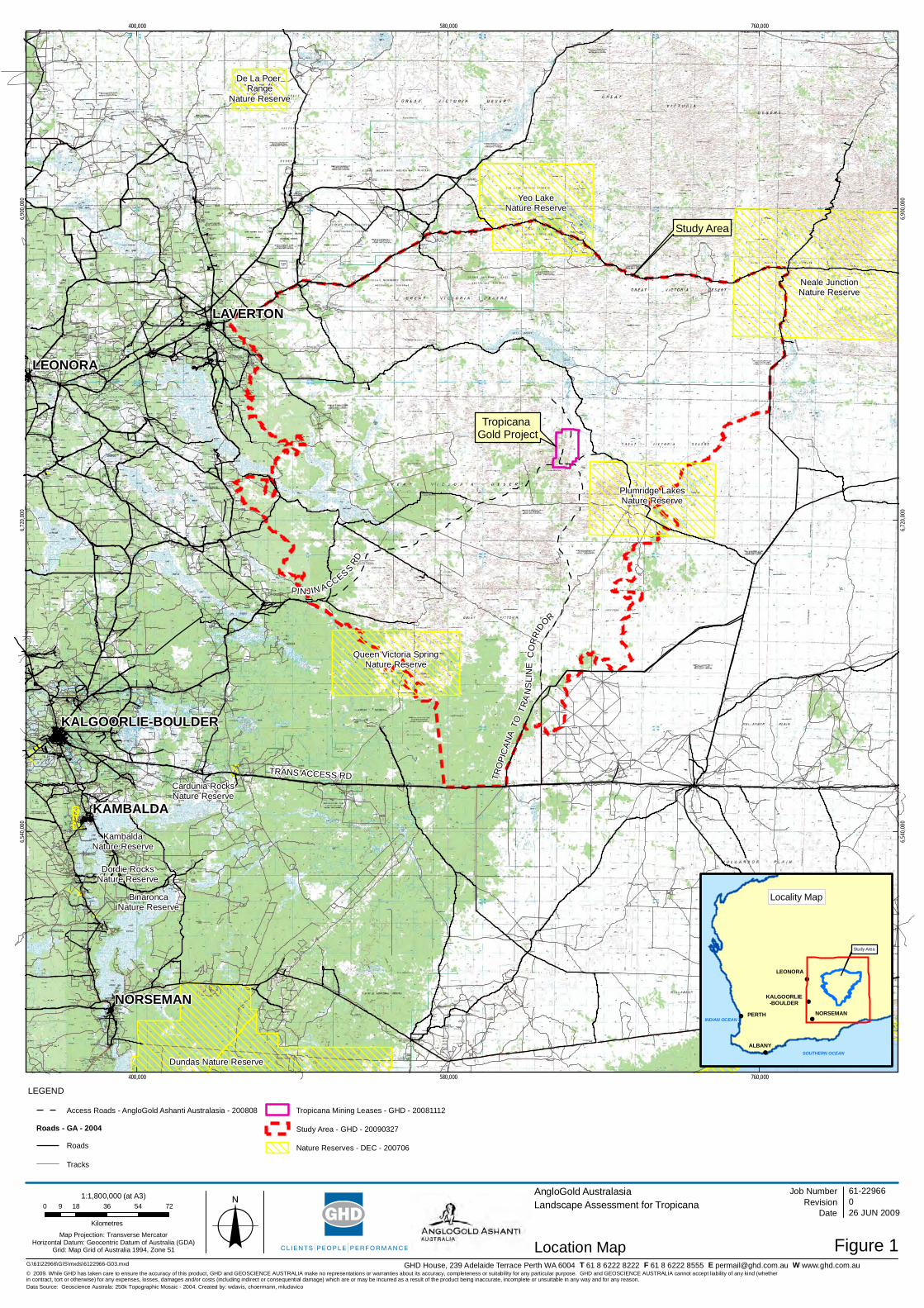
!
!
!
!!
!
Neale JunctionNature Reserve
Yeo LakeNature Reserve
Dundas Nature Reserve
Plumridge LakesNature Reserve
Queen Victoria SpringNature Reserve
De La PoerRange
Nature Reserve
NuytslandNature Reserve
BinaroncaNature Reserve
Dordie RocksNature Reserve
Cardunia RocksNature Reserve
KambaldaNature Reserve
TropicanaGold Project
TRANS ACCESS RD
PINJIN ACCESS RD
Study Area
TRO
PIC
ANA
TO
TRA
NS
LIN
E C
OR
RID
OR
LEONORA
NORSEMAN
KAMBALDA
LAVERTON
KALGOORLIE-BOULDER
400,000
400,000
580,000
580,000
760,000
760,000
6,540
,000
6,540
,000
6,720
,000
6,720
,000
6,900
,000
6,900
,000
G:\61\22966\GIS\mxds\6122966-G03.mxd
LEGEND
0 18 36 54 729
KilometresMap Projection: Transverse Mercator
Horizontal Datum: Geocentric Datum of Australia (GDA)Grid: Map Grid of Australia 1994, Zone 51 o
© 2009. While GHD has taken care to ensure the accuracy of this product, GHD and GEOSCIENCE AUSTRALIA make no representations or warranties about its accuracy, completeness or suitability for any particular purpose. GHD and GEOSCIENCE AUSTRALIA cannot accept liability of any kind (whetherin contract, tort or otherwise) for any expenses, losses, damages and/or costs (including indirect or consequential damage) which are or may be incurred as a result of the product being inaccurate, incomplete or unsuitable in any way and for any reason.
AngloGold AustralasiaLandscape Assessment for Tropicana
Figure 1
Job NumberRevision 0
61-22966
26 JUN 2009
Location Map
Date
Data Source: Geoscience Australa: 250k Topographic Mosaic - 2004. Created by: wdavis, choermann, mludovico
GHD House, 239 Adelaide Terrace Perth WA 6004 T 61 8 6222 8222 F 61 8 6222 8555 E [email protected] W www.ghd.com.au
!
!
!
!!
Study Area
SOUTHERN OCEAN
INDIAN OCEANPERTH
ALBANY
LEONORA
NORSEMAN
KALGOORLIE-BOULDER
Locality Map
1:1,800,000 (at A3)
Access Roads - AngloGold Ashanti Australasia - 200808
Roads - GA - 2004
Roads
Tracks
Tropicana Mining Leases - GHD - 20081112
Study Area - GHD - 20090327
Nature Reserves - DEC - 200706
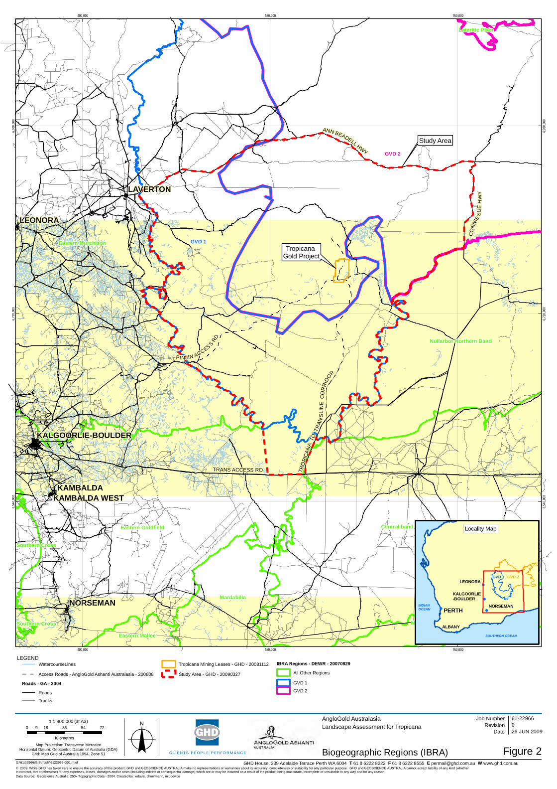
!
!
!
!!
!
TropicanaGold Project
TRANS ACCESS RD TRO
PIC
ANA
TO
TR
ANS
LIN
EC
OR
RID
O
R
PINJIN ACCESS RD
Study Area
GVD 1
GVD 2
Eastern Murchison
Eastern Goldfield Central band, Nullabor Plain
Nullarbor Northern Band
Mardabilla
Mardabilla
Eastern Mallee
HamptonEastern Mallee
Southern Cross
Lateritic Plain
Southern Cross
LEONORA
NORSEMAN
KAMBALDA
LAVERTON
KAMBALDA WEST
KALGOORLIE-BOULDER
400,000
400,000
580,000
580,000
760,000
760,000
6,540
,000
6,540
,000
6,720
,000
6,720
,000
6,900
,000
6,900
,000
G:\61\22966\GIS\mxds\6122966-G01.mxd
LEGEND
0 18 36 54 729
KilometresMap Projection: Transverse Mercator
Horizontal Datum: Geocentric Datum of Australia (GDA)Grid: Map Grid of Australia 1994, Zone 51 o
© 2009. While GHD has taken care to ensure the accuracy of this product, GHD and GEOSCIENCE AUSTRALIA make no representations or warranties about its accuracy, completeness or suitability for any particular purpose. GHD and GEOSCIENCE AUSTRALIA cannot accept liability of any kind (whetherin contract, tort or otherwise) for any expenses, losses, damages and/or costs (including indirect or consequential damage) which are or may be incurred as a result of the product being inaccurate, incomplete or unsuitable in any way and for any reason.
AngloGold AustralasiaLandscape Assessment for Tropicana
Figure 2
Job NumberRevision 0
61-22966
26 JUN 2009
Biogeographic Regions (IBRA)
Date
Data Source: Geoscience Australia: 250k Topographic Data - 2004. Created by: wdavis, choermann, mludovico
GHD House, 239 Adelaide Terrace Perth WA 6004 T 61 8 6222 8222 F 61 8 6222 8555 E [email protected] W www.ghd.com.au
!
!
!
!!
INDIAN OCEAN
INDIANOCEAN
SOUTHERN OCEAN
GVD 1 GVD 2
PERTH
ALBANY
LEONORA
NORSEMAN
KALGOORLIE-BOULDER
Locality Map
WatercourseLines
Access Roads - AngloGold Ashanti Australasia - 200808
Roads - GA - 2004
Roads
Tracks
Tropicana Mining Leases - GHD - 20081112
Study Area - GHD - 20090327
IBRA Regions - DEWR - 20070929
All Other Regions
GVD 1
GVD 2
1:1,800,000 (at A3)
CO
NN
IES
UE
HW
Y
ANN BEADELL HWY
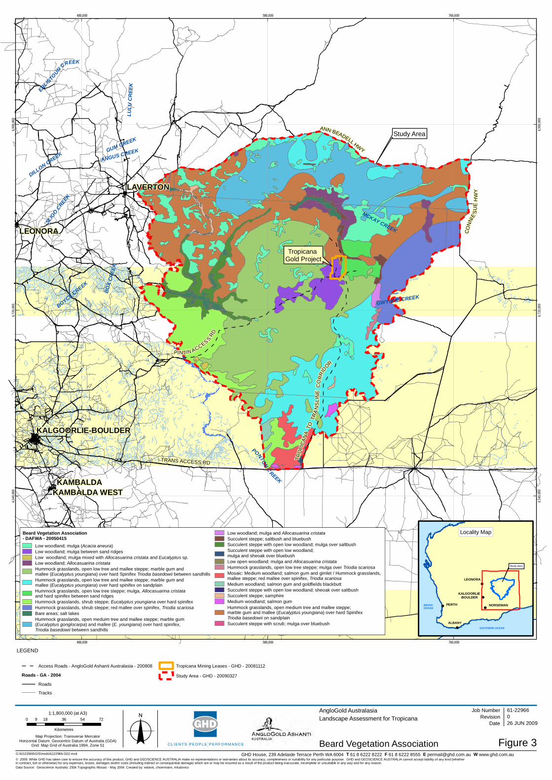
!
!
!
!!
!
TropicanaGold Project
TRANS ACCESS RD
PINJIN ACCESS RD
Study Area
TRO
PIC
ANA
TO
TRA
NS
LIN
EC
OR
RID
OR
PONTON
C
REEK
ERLISTOUN
CREEK
BO
X C
REE
K
DILLON CREEK
GWYNNE CREEK
MCKAY CREEK
ANGUS CREEK
BOYCE CREEK
SLIG
O CREE
K
LULU
CR
EEK
GUM CREEK
LEONORA
NORSEMAN
KAMBALDA
LAVERTON
KAMBALDA WEST
KALGOORLIE-BOULDER
400,000
400,000
580,000
580,000
760,000
760,000
6,540
,000
6,540
,000
6,720
,000
6,720
,000
6,900
,000
6,900
,000
G:\61\22966\GIS\mxds\6122966-G02.mxd
LEGEND
0 18 36 54 729
KilometresMap Projection: Transverse Mercator
Horizontal Datum: Geocentric Datum of Australia (GDA)Grid: Map Grid of Australia 1994, Zone 51 o
© 2009. While GHD has taken care to ensure the accuracy of this product, GHD and GEOSCIENCE AUSTRALIA make no representations or warranties about its accuracy, completeness or suitability for any particular purpose. GHD and GEOSCIENCE AUSTRALIA cannot accept liability of any kind (whetherin contract, tort or otherwise) for any expenses, losses, damages and/or costs (including indirect or consequential damage) which are or may be incurred as a result of the product being inaccurate, incomplete or unsuitable in any way and for any reason.
AngloGold AustralasiaLandscape Assessment for Tropicana
Figure 3
Job NumberRevision 0
61-22966
26 JUN 2009
Beard Vegetation Association
Date
Data Source: Geoscience Australia: 250k Topographic Mosaic - May 2004. Created by: wdavis, choermann, mludovico
GHD House, 239 Adelaide Terrace Perth WA 6004 T 61 8 6222 8222 F 61 8 6222 8555 E [email protected] W www.ghd.com.au
!
!
!
!!
Study Area
SOUTHERN OCEAN
INDIANOCEAN
PERTH
ALBANY
LEONORA
NORSEMAN
KALGOORLIE-BOULDER
Locality Map
1:1,800,000 (at A3)
Access Roads - AngloGold Ashanti Australasia - 200808
Roads - GA - 2004
Roads
Tracks
Tropicana Mining Leases - GHD - 20081112
Study Area - GHD - 20090327
CO
NNI
ES
UE
HW
Y
ANN BEADELL HWY
Beard Vegetation Association- DAFWA - 20050415
Low woodland; mulga (Acacia aneura)Low woodland; mulga between sand ridgesLow woodland; mulga mixed with Allocasuarina cristata and Eucalyptus sp.Low woodland; Allocasuarina cristataHummock grasslands, open low tree and mallee steppe; marble gum andmallee (Eucalyptus youngiana) over hard Spinifex Triodia basedowii between sandhillsHummock grasslands, open low tree and mallee steppe; marble gum andmallee (Eucalyptus youngiana) over hard spinifex on sandplainHummock grasslands, open low tree steppe; mulga, Allocasuarina cristataand hard spinifex between sand ridgesHummock grasslands, shrub steppe; Eucalyptus youngiana over hard spinifexHummock grasslands, shrub steppe; red mallee over spinifex, Triodia scariosaBare areas; salt lakesHummock grasslands, open meduim tree and mallee steppe; marble gum(Eucalyptus gonglocarpa) and mallee (E. youngiana) over hard spinifex,Triodia basedowii between sandhills
Low woodland; mulga and Allocasuarina cristataSucculent steppe; saltbush and bluebushSucculent steppe with open low woodland; mulga over saltbushSucculent steppe with open low woodland;mulga and sheoak over bluebushLow open woodland; mulga and Allocasuarina cristataHummock grasslands, open low tree steppe; mulga over Triodia scariosaMosaic: Medium woodland; salmon gum and gimlet / Hummock grasslands,mallee steppe; red mallee over spinifex, Triodia scariosaMedium woodland; salmon gum and goldfields blackbuttSucculent steppe with open low woodland; sheoak over saltbushSucculent steppe; samphireMedium woodland; salmon gumHummock grasslands, open medium tree and mallee steppe;marble gum and mallee (Eucalyptus youngiana) over hard SpinifexTriodia basedowii on sandplainSucculent steppe with scrub; mulga over bluebush

61/22966/83368 Tropicana Gold ProjectLandscape Assessment
Appendix B
Referral Document
Version 6 26/7/07
1
EPA
REF
ERR
AL
FOR
M
Pro
pone
nt
Referral of a Proposal to the Environmental Protection Authority under Section 38(1) of the Environmental Protection Act. Referral by the Proponent
PURPOSE OF THIS FORM Section 38(1) of the Environmental Protection Act 1986 provides that where a development proposal is likely to have a significant effect on the environment, a proponent may refer the proposal to the Environmental Protection Authority (EPA) for a decision on whether or not it requires assessment under the Act.
A referral to the EPA by a proponent under Section 38(1) must be made on this form.
Before completing this form, proponents are encouraged to familiarise themselves with the EPA’s General Guide for Referral of Proposals to the EPA under section 38(1) of the EP Act 1986 (accessed at the EPA’s website at www.epa.wa.gov.au or by contacting the EPA on 6467 5419).
Proponents need to complete Parts A and B of the form by marking the appropriate boxes and providing explanatory or additional information where requested. Part B should be completed based on information known to the proponent. Only those sections of Part B that are pertinent to the proposal need to be completed. If space is insufficient, attach additional pages. Where information is contained in a report that is to be submitted with the referral form, the proponent may complete sections of the form by referring to the pertinent section of the report.
Proponents are encouraged to attach any other environmental information they consider may be relevant to the EPA for making a decision on whether or not to assess the proposal, and, if it is to be assessed, the level of assessment. In general, referrals should contain information on the potential environmental impacts of the proposal, the proposed management mechanisms to be implemented to minimise and mitigate for these impacts, and how the principles of the EP Act have been addressed by the proposal.
In addition to providing a hard copy of referral documentation, proponents are also requested to provide an electronic copy of the referral document, noting that section 39(2) of the EP Act provides for a proponent to request that matters of a confidential nature not be kept on the public record. If confidential matters are included in the referral, proponents are requested to identify the confidential information at this stage of the process, specifically request that it be treated as confidential, and submit the confidential information in a separate hard copy attachment to the referral document. The electronic copy of the referral should be identical to the hard copy of the referral document, excluding any confidential attachment.
You may need to contact government agencies or local authorities to obtain information required by this form. A list of key agencies and their contact details is provided in Attachment 1.
Where the EPA decides that a proposal will be assessed at the level of Public Environmental Review or Environmental Review and Management Programme, it will also require the proponent to prepare an Environmental Scoping Document (refer Environmental Impact Assessment (Part IV Division 1) Administrative Procedures 2002).
Proponents should also be aware of the need to determine their obligations under the Commonwealth Environment Protection and Biodiversity Conservation Act 1999 (EPBC Act). The EPBC Act is separate legislation to the Environmental Protection Act and it identifies a number of matters of national environmental significance which are subject to assessment and approval by the Commonwealth. The matters identified as triggers for the Commonwealth assessment and approval regime are World Heritage properties, Ramsar wetlands, nationally threatened species and ecological communities, migratory species, Commonwealth marine areas, and nuclear actions (refer to the Department of Environment and Water Resources website at www.environment.gov.au). Questions in this referral form that may be relevant to matters of national environmental significance are marked with a #.

Version 6 26/7/07
2
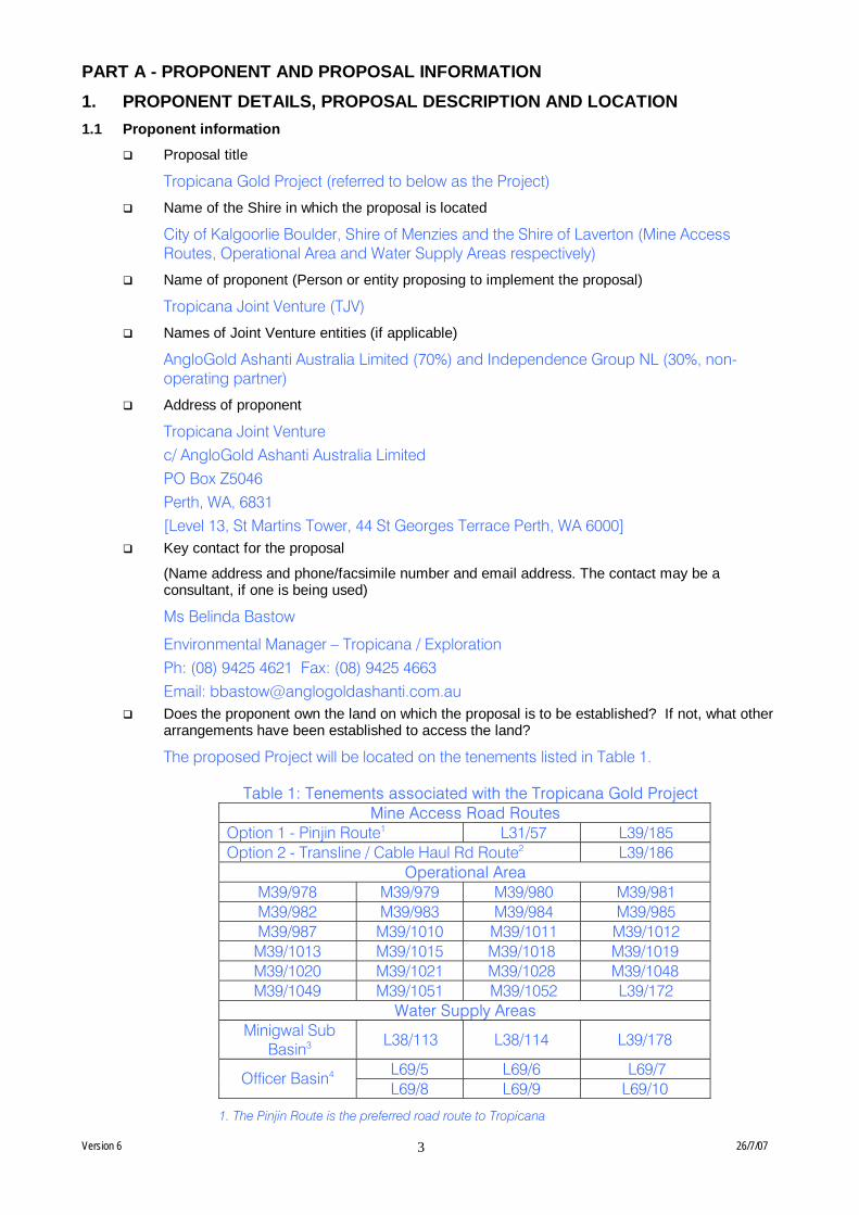
Version 6 26/7/07
3
PART A - PROPONENT AND PROPOSAL INFORMATION 1. PROPONENT DETAILS, PROPOSAL DESCRIPTION AND LOCATION 1.1 Proponent information
Proposal title
Tropicana Gold Project (referred to below as the Project)
Name of the Shire in which the proposal is located
City of Kalgoorlie Boulder, Shire of Menzies and the Shire of Laverton (Mine Access Routes, Operational Area and Water Supply Areas respectively)
Name of proponent (Person or entity proposing to implement the proposal)
Tropicana Joint Venture (TJV)
Names of Joint Venture entities (if applicable)
AngloGold Ashanti Australia Limited (70%) and Independence Group NL (30%, non-operating partner)
Address of proponent
Tropicana Joint Venture c/ AngloGold Ashanti Australia Limited PO Box Z5046 Perth, WA, 6831 [Level 13, St Martins Tower, 44 St Georges Terrace Perth, WA 6000]
Key contact for the proposal
(Name address and phone/facsimile number and email address. The contact may be a consultant, if one is being used)
Ms Belinda Bastow
Environmental Manager – Tropicana / Exploration Ph: (08) 9425 4621 Fax: (08) 9425 4663 Email: [email protected]
Does the proponent own the land on which the proposal is to be established? If not, what other arrangements have been established to access the land?
The proposed Project will be located on the tenements listed in Table 1.
Table 1: Tenements associated with the Tropicana Gold Project Mine Access Road Routes
Option 1 - Pinjin Route1 L31/57 L39/185 Option 2 - Transline / Cable Haul Rd Route2 L39/186
Operational Area M39/978 M39/979 M39/980 M39/981 M39/982 M39/983 M39/984 M39/985 M39/987 M39/1010 M39/1011 M39/1012 M39/1013 M39/1015 M39/1018 M39/1019 M39/1020 M39/1021 M39/1028 M39/1048 M39/1049 M39/1051 M39/1052 L39/172
Water Supply Areas Minigwal Sub
Basin3 L38/113 L38/114 L39/178
L69/5 L69/6 L69/7 Officer Basin4 L69/8 L69/9 L69/10
1. The Pinjin Route is the preferred road route to Tropicana
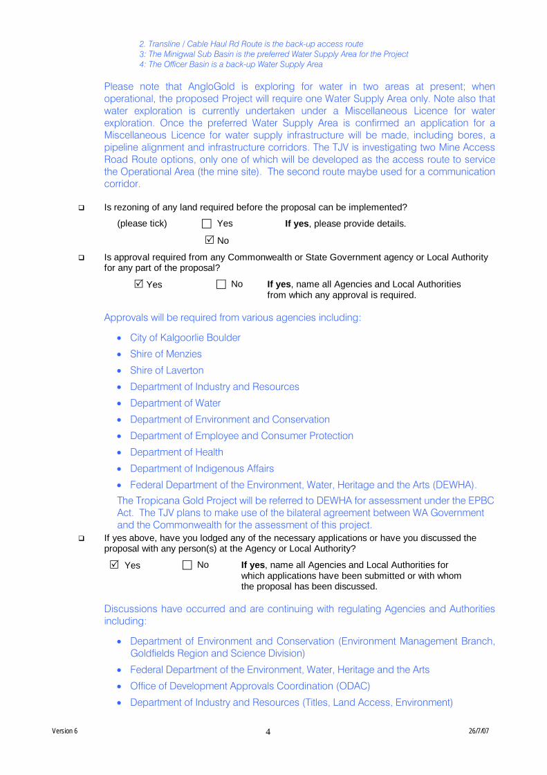
Version 6 26/7/07
4
2. Transline / Cable Haul Rd Route is the back-up access route 3: The Minigwal Sub Basin is the preferred Water Supply Area for the Project 4: The Officer Basin is a back-up Water Supply Area
Please note that AngloGold is exploring for water in two areas at present; when operational, the proposed Project will require one Water Supply Area only. Note also that water exploration is currently undertaken under a Miscellaneous Licence for water exploration. Once the preferred Water Supply Area is confirmed an application for a Miscellaneous Licence for water supply infrastructure will be made, including bores, a pipeline alignment and infrastructure corridors. The TJV is investigating two Mine Access Road Route options, only one of which will be developed as the access route to service the Operational Area (the mine site). The second route maybe used for a communication corridor.
Is rezoning of any land required before the proposal can be implemented?
(please tick) Yes If yes, please provide details.
No
Is approval required from any Commonwealth or State Government agency or Local Authority for any part of the proposal?
Yes No If yes, name all Agencies and Local Authorities from which any approval is required.
Approvals will be required from various agencies including:
• City of Kalgoorlie Boulder
• Shire of Menzies
• Shire of Laverton
• Department of Industry and Resources
• Department of Water
• Department of Environment and Conservation
• Department of Employee and Consumer Protection
• Department of Health
• Department of Indigenous Affairs
• Federal Department of the Environment, Water, Heritage and the Arts (DEWHA).
The Tropicana Gold Project will be referred to DEWHA for assessment under the EPBC Act. The TJV plans to make use of the bilateral agreement between WA Government and the Commonwealth for the assessment of this project.
If yes above, have you lodged any of the necessary applications or have you discussed the proposal with any person(s) at the Agency or Local Authority?
Yes No If yes, name all Agencies and Local Authorities for which applications have been submitted or with whom the proposal has been discussed.
Discussions have occurred and are continuing with regulating Agencies and Authorities including:
• Department of Environment and Conservation (Environment Management Branch, Goldfields Region and Science Division)
• Federal Department of the Environment, Water, Heritage and the Arts
• Office of Development Approvals Coordination (ODAC)
• Department of Industry and Resources (Titles, Land Access, Environment)

Version 6 26/7/07
5
• Department of Employee and Consumer Protection
• Department of Water
• Shire of Menzies
• City of Kalgoorlie Boulder
• Shire of Laverton
• Office of Native Title
• Department of Indigenous Affairs
What is the current land use on the property, and the extent (area in hectares) of the property?
The Operational Area of the proposed Project is located on granted Mining Leases and situated over vacant Crown Land approximately 330km east-northeast of Kalgoorlie and 14km northwest of the Plumridge Lakes Nature Reserve (see Figure 1). These Mining Leases are jointly held by AngloGold and Independence Group NL (the TJV). The Officer Basin water exploration areas abut the Neale Junction Nature Reserve and are situated on vacant Crown Land. The Minigwal Basin water exploration area is approximately 200km east of Laverton and is also located on vacant Crown Land. The current land use of both Road Route options is a combination of existing tracks and roads, and vacant Crown Land. Both road options and both potential water supply areas are shown on Figure 1. The tenement areas associated with the Project are as follows:
Mining Leases 17,080ha Pinjin Access Route Miscellaneous Licences 24,000ha Transline/Caul Haul Rd Route Miscellaneous Licences 4,300ha Minigwal Sub Basin Miscellaneous Licences 160,000ha Officer Basin Miscellaneous Licences 337,000ha
1.2 Proposal Description (Please attach extra pages where necessary)
Provide a description of the proposal.
The proposed Project aims to establish an open-cut gold mine, processing plant and associated infrastructure located approximately 330km east northeast of Kalgoorlie and 230km east of Laverton (Figure 1). The Project will consist of:
• A series of open-cut pits producing up to 7.5Mt/pa of ore and up to 60Mt/pa of waste rock with an anticipated mine life of 10 years.
• Waste rock dumps, low-grade (L/G) stockpiles and Run-of-Mine (ROM) storage area. The waste landform will comprise a series of waste rock dumps that will store up to 600Mt of waste rock and L/G material.
• Crushing and grinding circuit comprising of a primary crusher, High Pressure Grinding Rolls (HPGR), fine ore stockpile (50Kt) and a mill (either semi-autogenous grinding (SAG) or a Ball Mill),
• A Carbon in Pulp (CIP) processing plant with a production capacity of up to 6.5Mt/pa. The CIP plant proposed for the Project is a typical gold processing plant used in Western Australia. The CIP processing plant will contain two thickeners (for leach and tailings), two leach tanks, six Carbon in Leach tanks (CIL), an elution circuit, carbon regeneration kiln, cyanide destruction circuit and gold recovery system.
• A Tailings Storage Facility (TSF) with a storage capacity of up to 65Mt and associated tailing and water recovery pipelines (approximately 6km of High Density Poly-ethylene (HDPE) pipe of 250 - 400mm diameter).
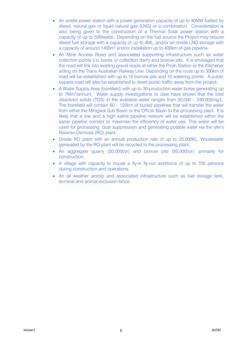
Version 6 26/7/07
6
• An onsite power station with a power generation capacity of up to 40MW fuelled by diesel, natural gas or liquid natural gas (LNG) or a combination. Consideration is also being given to the construction of a Thermal Solar power station with a capacity of up to 50Mwatts. Depending on the fuel source the Project may require diesel fuel storage with a capacity of up to 4ML, and/or an onsite LNG storage with a capacity of around 1400m3 and/or installation up to 400km of gas pipeline.
• An Mine Access Road and associated supporting infrastructure such as water collection points (i.e. bores or collection dam) and borrow pits. It is envisaged that the road will link into existing gravel roads at either the Pinjin Station or the Kitchener siding on the Trans Australian Railway Line. Depending on the route up to 300km of road will be established with up to 15 borrow pits and 10 watering points. A public bypass road will also be established to divert public traffic away from the project.
• A Water Supply Area (borefield) with up to 30-production water bores generating up to 7Mm3/annum. Water supply investigations to date have shown that the total dissolved solids (TDS) in the available water ranges from 30,000 – 240,000mg/L. The borefield will contain 60 – 120km of buried pipelines that will transfer the water from either the Minigwal Sub Basin or the Officer Basin to the processing plant. It is likely that a low and a high saline pipeline network will be established within the same pipeline corridor to maximise the efficiency of water use. This water will be used for processing, dust suppression and generating potable water via the site’s Reverse Osmosis (RO) plant.
• Onsite RO plant with an annual production rate of up to 20,000KL. Wastewater generated by the RO plant will be recycled to the processing plant.
• An aggregate quarry (50,000t/yr) and borrow pits (50,000t/yr), primarily for construction.
• A village with capacity to house a fly-in fly-out workforce of up to 700 persons during construction and operations.
• An all weather airstrip and associated infrastructure such as fuel storage tank, terminal and animal exclusion fence.
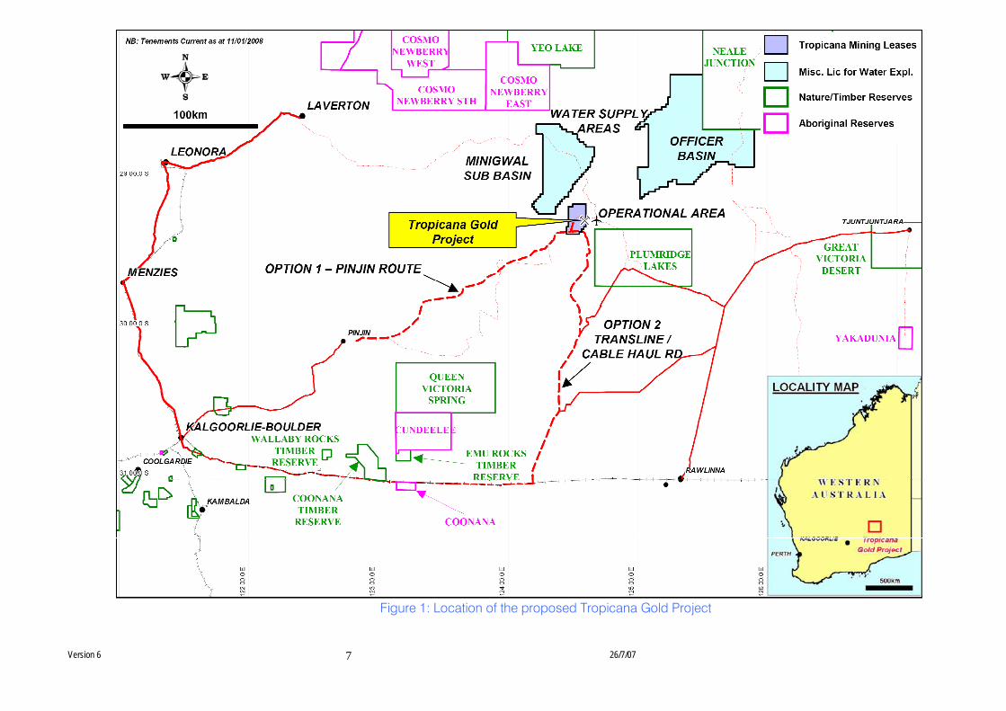
Version 6 26/7/07
7
Figure 1: Location of the proposed Tropicana Gold Project
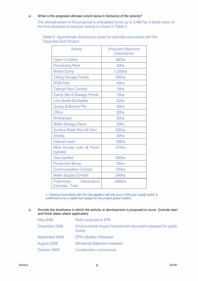
Version 6 26/7/07
8
What is the proposed ultimate extent (area in hectares) of the activity?
The ultimate extent of the proposal is anticipated to be up to 3,495 ha. A break down of the final disturbance area per activity is shown in Table 2.
Table 2: Approximate disturbance areas for activities associated with the Tropicana Gold Project
Activity Proposed Maximum Disturbance
Open Cut Mine 400ha
Processing Plant 30ha
Waste Dump 1,200ha
Tailing Storage Facility 350ha
ROM Pad 40ha
Tailings Pipe Corridor 15ha
Camp Site & Sewage Ponds 15ha
Low Grade Stockpiles 50ha
Quarry & Borrow Pits 30ha
Office 20ha
Workshops 20ha
Water Storage Dams 20ha
Surface Water Run-off Dam 220ha
Airstrip 50ha
Internal roads 100ha
Mine Access road (& Public bypass)
315ha
Gas pipeline1 200ha
Production Bores 30ha
Communication Corridor 150ha
Water Supply Corridor 240ha
Preliminary Disturbance Estimate - Total
3495ha
1. Clearing associated with the Gas pipeline will only occur if the gas supply option is confirmed to be a viable fuel supply for the project power station.
Provide the timeframe in which the activity or development is proposed to occur. (Include start and finish dates where applicable)
May 2008 Refer proposal to EPA
December 2008 Environmental Impact Assessment document released for public review
September 2009 EPA’s Bulletin Released
August 2009 Ministerial Statement released
October 2009 Construction commences
Version 6 26/7/07
9
Provide details of any staging of the proposal.
It is envisaged that the Project will progressively increase the number/size of open-cut pits over the life of the Project. The total area proposed to be cleared for the pits would not exceed 400ha based on current exploration knowledge. This proposal is based on the assumed maximal pit-size of 400ha.
Additional Exploration will occur within region as approved under the Mining Act 1978 Programme of Work process.
Indicate whether, and in what way, the proposal is related to other proposals in the region.
The TJV has existing approvals for mineral and water exploration within and adjacent to the operational area. This work plus normal regional exploration activities will continue as approved under the Mining Act 1978 Programme of Work process while the Project undergoes the Environmental Impact Assessment process.
1.3 Location information
Provide proposal location details in the following two ways:
a) Electronic spatial data b) GIS or CAD on CD, depicting the proposal extent, geo-referenced and conforming to the
following parameters:
• datum: GDA94 • projection: Geographic (latitude/longitude) or Map Grid of Australia (MGA) • format: Arcview shapefile, Arcinfo coverages, Microstation or AutoCAD.
AND b) Maps and/or directions Any maps or diagrams of the proposal, together with the following directions:
• for urban areas: street address, lot number, the suburb and nearest road intersection;
• for remote localities: the nearest town, together with distance and direction from that town to the proposal site.
See Figure 1 for the location of the proposed mine. The nearest large towns are Kalgoorlie (330km west-south-west of the proposed Operational Area) and Laverton (230km west).
Please also attach the following map/plans, clearly showing the location of the development in its regional and local context.
See Figures 2 - 4 below. Figures 2 and 3 show the general locality, proposed disturbance areas and existing environment for all infrastructure associated with the Project (Operational Area, Mine Access Road and Water Supply Area). As stated above, please note that only one Mine Access Road and only one Water Supply Area will be required for the Project. Figure 4 shows the site of the proposed Operational Area in more detail, as this area will be more significantly disturbed by the proposed Project than the Mine Access Road and the Water Supply Area. Other than the TJVs exploration activities in the vicinity of the Operational Area (approved under the Mining Act 1978) the area is largely undisturbed by human influences. Bush fires have affected vegetation in some parts of the Operational Area and Mine Access Road Routes.
Locality plan – Broad Scale
Provide a locality plan (preferably superimposed on an aerial photograph) to identify:
• proposed development site and any associated infrastructure • main roads • urban centres • wetlands and watercourses
Version 6 26/7/07
10
• remnant native vegetation • adjoining land uses (including recreation) • sensitive marine areas
See Figure 2 below. Other than approved disturbances (by the Tropicana JVs exploration activities in the area) the vegetation is undisturbed; while bush fires have affected some areas.
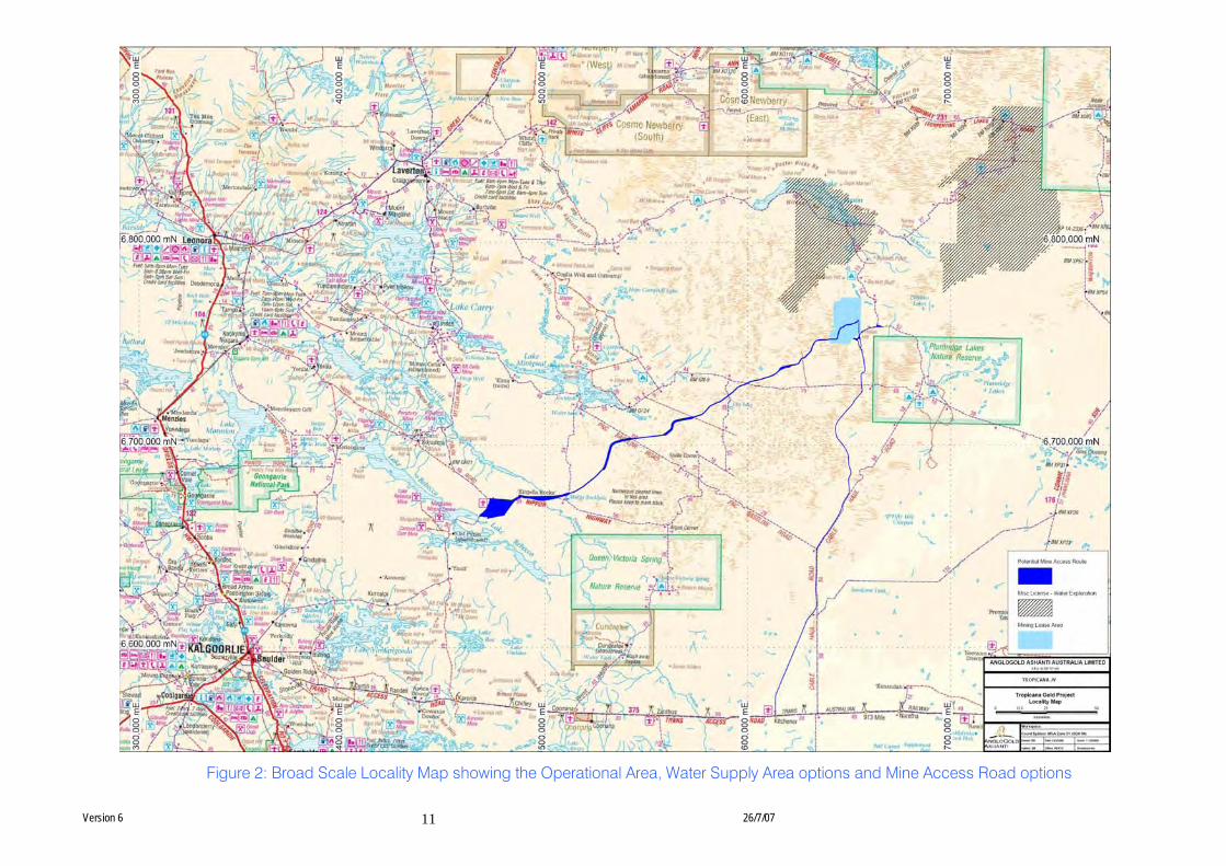
Version 6 26/7/07
11
Figure 2: Broad Scale Locality Map showing the Operational Area, Water Supply Area options and Mine Access Road options
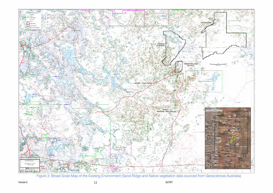
Version 6 26/7/07
12
Figure 3: Broad Scale Map of the Existing Environment (Sand Ridge and Native vegetation data sourced from Geosciences Australia)

Version 6 26/7/07
13
Figure 4: Conceptual Site Layout and Existing Environment at the proposed Operational Area.
Note that only one village of the three mapped options will be constructed and that the airstrip and quarry will be located within the bounded area (northern portion of figure), and will not require clearing of the entire bounded area
Version 6 26/7/07
14
Site Plan – Proposal Details
Provide a site plan to scale and indicate the location of:
• lot boundaries
• road frontages
• extent of the proposed development area
• extent of the proposed buffer area (if applicable)
Site Plan – Existing Environment
Provide a site plan to scale (the same scale as above) and indicate the location of:
• lot boundaries
• road frontages
• any information required to be shown from Section 2.2 of this form
• extent of native vegetation of the site (the extent of overlap between the proposed development area and the area of native vegetation must be highlighted)
• extent of hydrological features on the site (this includes wetlands, watercourses, creek lines, seasonal creeks and artificial drainage lines)
• sensitive marine areas
PART B - ENVIRONMENTAL IMPACTS AND MANAGEMENT COMMITMENTS
2. ENVIRONMENTAL IMPACTS
Describe the impacts of the proposal on the following elements of the environment, through the questions below:
(i) flora and vegetation #;
(ii) fauna #;
(iii) rivers, creeks, wetlands and estuaries;
(iv) significant areas and/ or land features;
(v) coastal zone areas;
(vi) marine areas and biota #;
(vii) water supply and drainage catchments;
(viii) pollution;
(ix) greenhouse gas emissions;
(x) contamination;
(xi) social surroundings; and
(xii) risk.
These features should be shown on the site plan, where appropriate)
For all information, please indicate:
(a) the source of the information; and
(b) the currency of the information.
2.1 Flora and Vegetation
Do you propose to clear any native flora and vegetation as a part of this proposal?
Version 6 26/7/07
15
(A proposal to clear native vegetation may require a clearing permit under Part V of the EP Act (Environmental Protection (Clearing of Native Vegetation) Regulations 2004). Please contact the Department of Environment and Conservation (DEC) for more information.
(please tick) Yes If yes, complete the rest of this section
No If no, go to the next section
How much vegetation are you proposing to clear (in hectares)?
Up to 3,495ha.
Have you submitted an application to clear native vegetation to the DEC (unless you are exempt from such a requirement)?
Yes No If yes, on what date and to which office was the application submitted of the DEC?
Are you aware of any recent flora surveys carried out over the area to be disturbed by this proposal?
Yes No If yes, please attach a copy of any related survey reports and provide the date and name of persons / companies involved in the survey/s. (If no, please do not arrange to have any biological surveys conducted prior to consulting with the DEC.)
Prior to commencing exploration activities for the proposed Project, there was an absence of baseline flora information for the proposed Operational Area and its immediate vicinity. Some data was available for the adjacent Plumridge Lakes Nature Reserve and other DEC estates in the region (e.g., David Pearson 1994 PhD: The vegetation and flora of Queen Victoria Spring Nature Reserve, Western Australia), the TJV commissioned a baseline flora survey and targeted threatened species surveys for the Operational Area which have also encompassed the surrounding area to provide regional context. Both Mine Access Road Routes and the Minigwal Basin have also been surveyed. The TJVs surveys have identified, the presence of several species of conservation significance in the area, see below.
A summary of the work completed to date has been attached to this document. (Refer to attachment 1)
Has a search of DEC records for known occurrences of rare or priority flora or threatened ecological communities been conducted for the site? #
Yes No If you are proposing to clear native vegetation for any part of your proposal, a search of DEC records of known occurrences of rare or priority flora and threatened ecological communities will be required. Please contact DEC for more information.
Are there any known occurrences of rare or priority flora or threatened ecological communities on the site? #
Yes No If yes, please indicate which species or communities are involved and provide copies of any correspondence with DEC regarding these matters.
The flora surveys commissioned by the TJV have identified the presence of several species of Declared Rare and Priority Flora across the Operational Area, Mine Access Road Routes and the Minigwal Basin including:
Version 6 26/7/07
16
• Conospermum toddii (DRF)
• Baeckea sp. Sandstone (P1)
• Baeckea sp. Great Victoria Desert (P2)
• Dicrastylis nicholasii (P2)
• Grevillea secunda (P2)
• Malleostemon sp. Officer Basin (P2)
• Acacia eremophila (numerous nerved variant) (P3)
• Lepidobolus deserti (P3)
• Microcorys macredieana (P3)
• Micromyrtus stenocalyx (P3)
• Olearia arida (P3)
These species are also found in areas outside the proposed Project’s disturbance area. Vegetation mapping and flora survey have been undertaken over approximately 200,00ha.
If located within the Perth Metropolitan Region, is the proposed development within or adjacent to a listed Bush Forever Site? (You will need to contact the Bush Forever Office, at the Department for Planning and Infrastructure)
Yes No If yes, please indicate which Bush Forever site is affected (site number and name of site where appropriate).
What is the condition of the vegetation at the site?
Vegetation condition throughout the Operational Area varies from small areas of disturbed vegetation around mineral exploration bores and access tracks, to larger areas of fire affected vegetation and large areas of undisturbed vegetation.
Vegetation along both Mine Access Road Routes varies from highly disturbed areas along existing roads and tracks and/ or fire affected areas, to undisturbed vegetation.
Refer to Attachment 1 for more information on vegetation condition
2.2 Fauna
Do you expect that any fauna or fauna habitat will be impacted by the proposal?
(please tick) Yes If yes, complete the rest of this section
No If no, go to the next section
Describe the nature and extent of the expected impact.
Vegetation clearing will result in the loss of fauna habitat and will potentially result in the loss of individuals from a variety of terrestrial fauna species known to use habitat in and around the proposed Project area. The Operational Area will be most affected.
In particular, ground-disturbing activities at the proposed Operational Area including the establishment of the open-cut pits, waste dumps, and TSF will result in the removal of habitat known to be used by the Southern Marsupial Mole (SMM; Notorcytes typhlops). It is also possible that internal roads and other infrastructure including the village and airstrip will increase ground compaction in sandy areas, which are also inhabitated by the SMM. This may limit the ability of the SMM to move through the environment. Assessment of the likely risk and extent of impacts on the SMM is limited by a lack of current knowledge for the species. The TJV has commissioned extensive surveys for the SMM and has determined that they occur more frequently along sandy dunes and in sandy
Version 6 26/7/07
17
inter-dunal areas (rather than loam). Less than 10% (approximately 230 ha) of the proposed clearing and compaction impacts for the proposed Project will occur in preferred SMM habitat at Tropicana. This is a very small proportion (0.002%) of the Great Victoria Desert (the GVD which covers ~ 42Mha), which is one of the known habitats of the SMM. As a result of the surveys conducted by the TJV, the proposed operational footprint has been designed to avoid most of the dune area, which are known to be the preferred habitat of the SMM.
Following the successful rehabilitation of the site it is likely that affected faunal species will re-colonise of the Operational Area from neighbouring undisturbed areas.
Are you aware of any recent fauna surveys carried out over the area to be disturbed by this proposal?
Yes No If yes, please attach a copy of any related survey reports and provide the date and name of persons / companies involved in the survey/s. (If no, please do not arrange to have any biological surveys conducted prior to consulting with the DEC.)
There was an absence of detailed baseline fauna information for the proposed Project area existed prior to the commencement of the TJVs activities in the area. Some data was available for the adjacent Plumridge Lakes Nature Reserve and other DEC estate in the area. The TJV commissioned baseline terrestrial and subterranean fauna surveys, short-range endemic invertebrate surveys as well as targeted threatened species surveys for Southern Marsupial Mole and Sandhill Dunnart (Sminthopsis psammophila). These surveys have been conducted for the Operational Area and have also encompassed the surrounding area to provide regional context. Both Mine Access Road Routes and the Minigwal Basin have also been surveyed. The TJVs surveys have identified the presence of several species of conservation significance in the area, see below.
A summary report detailing all the fauna work undertaken by the TJV has been attached to this submission (Attachment 2).
Has a search of DEC records for known occurrences of Specially Protected (Threatened) fauna been conducted for the site?
Yes No (please tick)
Are there any known occurrences of Specially Protected (Threatened) fauna on the site? #
Yes No If yes, please indicate which species or communities are involved and provide copies of any correspondence with DEC regarding these matters.
The fauna surveys commissioned by the TJV have provided information on the presence of conservation significant fauna in and around the proposed Project area including the:
• Southern Marsupial Mole (Endangered)
• Malleefowl (Vulnerable)
• Sandhill Dunnart (Endangered)
• Peregrine Falcon (Schedule 4)
• Great Desert Skink (Vulnerable) (to be confirmed)
• Australian Bustard (P4)
• Rainbow Bee-eater (EPBC-protected – Migratory)
Version 6 26/7/07
18
2.3 Rivers, Creeks, Wetlands and Estuaries
Will the development occur within 200m of a river, creek, wetland or estuary?
(please tick) Yes If yes, complete the rest of this section
No If no, go to the next section
Will the development result in the clearing of vegetation within the 200 m zone?
Yes No If yes, please describe the extent of the expected impact.
Will the development result in the filling or excavation of a river, creek, wetland or estuary?
Yes No If yes, please describe the extent of the expected impact.
Will the development result in the impoundment of a river, creek, wetland or estuary?
Yes No If yes, please describe the extent of the expected impact.
Will the development result in draining to a river, creek, wetland or estuary?
Yes No If yes, please describe the extent of the expected impact.
Are you aware if the proposal will impact on a river, creek, wetland or estuary (or its buffer)
within one of the following categories? (please tick)
Conservation Category Wetland Yes No Unsure
Draft Environmental Protection (Swan Coastal Plain Wetlands) Policy 2004 Yes No Unsure
Environmental Protection (South West Agricultural Zone Wetlands) Policy 1998 Yes No Unsure
Perth’s Bush Forever site Yes No Unsure
Environmental Protection (Swan & Canning Rivers) Policy 1998 Yes No Unsure
The management area as defined in s4(1) of the Swan River Trust Act 1988 Yes No Unsure
Which is subject to an international agreement, because of the importance of the wetland for waterbirds and waterbird habitats (e.g. Ramsar, JAMBA, CAMBA) #
Yes No Unsure
2.4 Significant Areas and/ or Land Features
Is the proposed development located within or adjacent to an existing or proposed National Park or Nature Reserve?
Yes No If yes, please provide details.
Plumridge Lakes Nature Reserve is adjacent to the Operational Area (approximately 14km SE).
Are you aware of any Environmentally Sensitive Areas (as declared by the Minister under section 51B of the EP Act) that will be impacted by the proposed development?
Version 6 26/7/07
19
Yes No If yes, please provide details.
Are you aware of any significant natural land features (e.g. caves, ranges etc) that will be
impacted by the proposed development?
Yes No If yes, please provide details.
2.5 Coastal Zone Areas (Coastal Dunes and Beaches)
Will the development occur within 300m of a coastal area?
(please tick) Yes If yes, complete the rest of this section
No If no, go to the next section
What is the expected setback of the development from the high tide level and from the primary dune?
Will the development impact on coastal areas with significant landforms including beach ridge plain, cuspate headland, coastal dunes or karst?
Yes No If yes, please describe the extent of the expected impact.
Is the development likely to impact on mangroves?
Yes No If yes, please describe the extent of the expected impact.
2.6 Marine Areas and Biota
Is the development likely to impact on an area of sensitive benthic communities, such as seagrasses, coral reefs or mangroves?
Yes No If yes, please describe the extent of the expected impact.
Is the development likely to impact on marine conservation reserves or areas recommended for reservation (as described in A Representative Marine Reserve System for Western Australia, CALM, 1994)?
Yes No If yes, please describe the extent of the expected impact.
Is the development likely to impact on marine areas used extensively for recreation or for commercial fishing activities?
Yes No If yes, please describe the extent of the expected impact, and provide any written advice from relevant agencies (e.g. Fisheries WA).
2.7 Water Supply and Drainage Catchments
Are you in a proclaimed or proposed groundwater or surface water protection area?
(You may need to contact the Department of Water (DoW) for more information on the requirements for your location, including the requirement for licences for water abstraction. Also, refer to the DoW website)
Yes No If yes, please describe what category of area.
The Project area is within the Goldfields and Nullarbor Groundwater Management Area, both are Proclaimed Groundwater Areas. A small area is located in a non-prescribed water area.
Are you in an existing or proposed Underground Water Supply and Pollution Control area?
Version 6 26/7/07
20
(You may need to contact the DoW for more information on the requirements for your location, including the requirement for licences for water abstraction. Also, refer to the DoW website)
Yes No If yes, please describe what category of area.
Are you in a Public Drinking Water Supply Area (PDWSA)?
(You may need to contact the DoW for more information or refer to the DoW website. A proposal to clear vegetation within a PDWSA requires approval from DoW.)
Yes No If yes, please describe what category of area.
Is there sufficient water available for the proposal?
(Please consult with the DoW as to whether approvals are required to source water as you propose. Where necessary, please provide a letter of intent from the DoW)
Yes No (please tick)
Will the proposal require drainage of the land?
Yes No If yes, how is the site to be drained and will the drainage be connected to an existing Local Authority or Water Corporation drainage system? Please provide details.
Dewatering in parts of the Operational Area (e.g. the pit) will be required to facilitate the mining activities. Dewatering activities will occur via a series of dewatering bores and internal sumps. The water generated by these activities will be used for dust suppression and mineral processing.
Is there a water requirement for the construction and/ or operation of this proposal?
(please tick) Yes If yes, complete the rest of this section
No If no, go to the next section
What is the water requirement for the construction and operation of this proposal, in kl/year?
Up to 7ML/annum (water will be used for both processing and dust suppression).
What is the proposed source of water for the proposal? (eg dam, bore, surface water etc.)?
Bores in the Water Supply Area and surface water run-off from the Operational Area.
2.8 Pollution
Is there likely to be any discharge of pollutants from this development, such as noise, vibration, gaseous emissions, dust, liquid effluent, solid waste or other pollutants?
(please tick) Yes If yes, complete the rest of this section
No If no, go to the next section
Is the proposal a prescribed premise, under the Environmental Protection Regulations? (Refer to the EPA General Guide for Referral of Proposals to the EPA under section 38(1) of
the EP Act 1986 for more information)
Yes No If yes, please describe what category of prescribed premise.
Category 5 Processing or Benefaction of Metallic or Non Metallic Ore
Category 6 Mine Dewatering
Category 52 Power Generation (10Mw or more by fuel other natural gas)
Category 57 Used Tyre Storage (General)
Category 63 Class I inert Landfill
Category 64 Class II or III putrescibles Landfill site
Version 6 26/7/07
21
Category 73 Bulk Storage of chemicals
Category 85b Water Desalination Plant
Will the proposal result in gaseous emissions to air?
Yes No If yes, please briefly describe.
The Project will generate particulate matter, Volatile Organic Compounds (VOC), greenhouse gas emission s, nitrogen and sulfur oxides (NOx and SOx) and carbon monoxide from the Power Station and hydrogen cyanide (HCN) gas from the processing plant and TSF.
Have you done any modelling or analysis to demonstrate that air quality standards will be met, including consideration of cumulative impacts from other emission sources?
Yes No If yes, please briefly describe.
Will the proposal result in liquid effluent discharge?
Yes No If yes, please briefly describe the nature, concentrations and receiving environment.
If there is likely to be discharges to a watercourse or marine environment, has any analysis been done to demonstrate that the State Water Quality Management Strategy or other appropriate standards will be able to be met?
Yes No If yes, please describe. Not applicable
Will the proposal produce or result in solid wastes?
Yes No If yes, please briefly describe the nature, concentrations and disposal location/ method.
The Project will generate putrescible and general industrial waste, waste rock and processing wastes such as tailings. Putrescible waste and some industrial wastes will be disposed of in the onsite landfill to be located in the Operational Area. Other industrial wastes will be packaged up and sent off-site for disposal at authorised locations. The waste rock will be managed onsite and the tailings material will be disposed of in a specifically designed TSF.
Will the proposal result in significant off-site noise emissions?
Yes No If yes, please briefly describe.
Will the development be subject to the Environmental Protection (Noise) Regulations?
Yes No If yes, has any analysis been carried out to demonstrate that the proposal will comply with the Regulations?
Please attach the analysis.
Does the proposal have the potential to generate off-site, air quality impacts, dust, odour or another pollutant that may affect the amenity of residents and other “sensitive premises” such as schools and hospitals (proposals in this category may include intensive agriculture, aquaculture, marinas, mines and quarries etc.)?
Yes No If yes, please describe and provide the distance to residences and other “sensitive premises”.
If the proposal has a residential component or involves “sensitive premises”, is it located near a land use that may discharge a pollutant?
Yes No Not Applicable If yes, please describe and provide the distance to the potential pollution source
Version 6 26/7/07
22
2.9 Greenhouse Gas Emissions
Is this proposal likely to result in substantial greenhouse gas emissions (greater than 100 000 tonnes per annum of carbon dioxide equivalent emissions)?
Yes No If yes, please provide an estimate of the annual gross emissions in absolute and in carbon dioxide equivalent figures.
The Project is predicted to emit between 240,000 – 500,000t/annum.
Further, if yes, please describe proposed measures to minimise emissions, and any sink enhancement actions proposed to offset emissions.
The Project has been designed to optimise the energy efficiency of the plant and associated infrastructure and thus reduce energy consumption and greenhouse gas emissions. It is yet to be determined if the onsite Power Station will be a diesel or LNG or natural gas facility. Consideration is also being given to the establishment of a Thermal Solar Power Station.
In addition to the site Power Station, a remote power station will be required to pump water from the Water Supply Area, which will be located between 30 – 100km from the Operational Area.
Evaluation of renewable energy options such as photovoltaic solar panels and wind energy utilisation will be considered for non-base load requirements of the Project including village facilities and ancillary infrastructure.
2.10 Contamination
Has the property on which the proposal is to be located been used in the past for activities which may have caused soil or groundwater contamination?
Yes No Unsure If yes, please describe.
Has any assessment been done for soil or groundwater contamination on the site?
Yes No If yes, please describe.
Has the site been registered as a contaminated site under the Contaminated Sites Act 2003? (on finalisation of the CS Regulations and proclamation of the CS Act)
Yes No If yes, please describe.
2.11 Social Surroundings
Is the proposal on a property, which contains or is near a site of Aboriginal ethnographic or archaeological significance that may be disturbed?
Yes No Unsure If yes, please describe.
The TJV has undertaken detailed ethnographic and archaeological surveys since the commencement of exploration activities in the region. This work has located a number of archaeological sites such as gnamma holes, potential quarry site, artefact scatters, and breakaways containing caves and other material of interest.
The proposed footprint of the project and its supporting infrastructure have been designed to prevent the damage or destruction of any recorded site.
Is the proposal on a property which contains or is near a site of high public interest (for example, a major recreation area or natural scenic feature)?
Yes No If yes, please describe.
Will the proposal result in or require substantial transport of goods, which may affect the amenity of the local area?
Version 6 26/7/07
23
Yes No If yes, please describe.
Due to the remote location of the Project, all freight and production consumables will be transported to and from the site via road-trains during the construction, commissioning, operation and decommissioning of the mine. There will be no requirement to transport large quantities of product from the mine site as the processed gold will be small in volume (in comparison to other mining projects in WA which require the transport of large quantities of product e.g., nickel concentrate). It is not anticipated that transport requirements for the Project will negatively impact the amenity of the area, as the surrounding area is largely uninhabited (see Figure 1 for location of towns and settlements).
2.12 Risk
Is the proposal located near a hazardous industrial plant or high-pressure gas pipeline?
Yes No If yes, please describe.
Does the proposal have the potential to generate off-site risk?
Yes No If yes, will the proposal be a major hazardous facility regulated under the Explosives and Dangerous Goods Act?
The Project will be regulated under the Dangerous Goods Safety Act due to the need to store explosives, cyanide, aviation fuel and LNG.
3. MANAGEMENT 3.1 Principles of Environmental Protection
Have you considered how your project gives attention to the following Principles, as set out in section 4A of the EP Act? (For information on the Principles of Environmental Protection, please see EPA Position Statement No. 7, available on the EPA web.) 1. The precautionary principle. Yes No
2. The principle of intergenerational equity. Yes No
3. The principle of the conservation of biological diversity and ecological integrity.
Yes No
4. Principles relating to improved valuation, pricing and incentive mechanisms.
Yes No
5. The principle of waste minimisation. Yes No
Is the proposal consistent with the EPA’s Position Statements (available on the EPA web)?
Yes No
3.2 Management Commitments How has the proposal been developed to avoid, minimise and manage potential impacts?
Please describe any specific commitments you make as the proponent to minimising the potential environmental impacts of this development. Environmental surveys have been undertaken across the Project area and in adjacent areas to identify environmental constraints to the Project (i.e. heritage sites and threatened flora and fauna). The results of surveys completed to date have been used to
Version 6 26/7/07
24
site infrastructure in such a way as to minimise impact to the existing environment (e.g. the village will be sited away from preferred habitat of the SMM, and the Mine Access Road will be aligned to minimise environmental impacts).
In addition, environmental risk assessments have been conducted for the major components of the Project:
• Mine and Waste Rock management
• Crushing, Processing Plant and Tailings Storage Facility
• Village, Communications, Airstrip, Village, Logistics & Waste Management
• Project-wide issues
These workshops aimed to identify environmental risks and appropriate management practices. An Environmental Management Plan for the Project is being developed to document appropriate environmental management activities and techniques, and this will form part of the environmental documentation.
3.3 Consultation
Has public consultation taken place (such as with other government agencies, community groups or neighbours), or is it intended that consultation shall take place?
Yes No If yes, please list those consulted and attach comments or summarise response on a separate sheet.
Consultation has been undertaken with the following groups and is ongoing with key stakeholders:
• Department of Environment and Conservation (Environment Management Branch, Kalgoorlie Regional Division and Science Division)
• Federal Department of the Environment, Water, Heritage and the Arts
• Office of Development Approvals Coordination
• Department of Industry and Resources (Titles, Aboriginal Enterprises, Environment)
• Office of the Deputy Premier, Treasurer and Minister for State Development
• Department of Water (Kalgoorlie and Perth)
• Shire of Menzies
• City of Kalgoorlie Boulder
• Shire of Laverton
• Tjuntjuntjarra Aboriginal Corporation
• North East Independent Body as authorised representatives of the Wongatha people
• Office of Native Title
• Department of Indigenous Affairs
• Goldfields Land and Sea Council
• Goldfields Esperance Development Commission
• Conservation Council of Western Australia
• Wildflower Society (Perth and Kalgoorlie Region)
Version 6 26/7/07
25
• Wilderness Society (WA Branch)
• Rangelands NRM Coordinating Group
• Goldfields Naturalists
• World Wildlife Fund (WA, Threatened Species Group)
Consultations are schedule to occur with
• Friend of the Great Victoria Desert
• Malleefowl Preservation Society

Version 6 26/7/07
26
CHECKLIST AND DECLARATION
Before you submit this form, have you: YES NO
Completed all the questions on this form?
Have you attached any extra information, such as:
Site plans?
Detailed explanations?
Comments obtained during consultation?
Have you included any electronic information, such as:
A CD of the referral and documentation, in PDF format, excluding any confidential information?
A CD of the spatial data?
Any other relevant information?
Following a review of the information presented in this form, please consider the following question. (Your response is Optional) DO YOU CONSIDER THE PROPOSAL REQUIRES FORMAL ENVIRONMENTAL IMPACT ASSESSMENT?
(Information on the levels of environmental impact assessment is available on the EPA website at www.epa.wa.gov.au)
YES NO NOT SURE
IF YES, WHAT LEVEL OF ASSESSMENT?
ASSESSMENT ON REFERRAL INFORMATION
ENVIRONMENTAL PROTECTION STATEMENT
PUBLIC ENVIRONMENTAL REVIEW
ENVIRONMENTAL REVIEW AND MANAGEMENT PROGRAMME
STRATEGIC ENVIRONMENTAL ASSESSMENT
I Belinda Bastow declare that I have completed all of the questions in this form and attached the requested information and declare that the information contained in this form is, to my knowledge, true and not misleading.
Signature
Name Belinda Bastow
Position Environmental Manager, AngloGold Ashanti Australia Limited
Date
Version 6 26/7/07
27
Government Agency Contact Details Attachment 1
Environmental Protection Authority Level 8, The Atrium 168 St Georges Tce PERTH WA 6000
Please mail completed referrals to: Postal address: Locked Bag 33 CLOISTERS SQUARE WA 6850 Website: www.epa.wa.gov.au
EPA Service Unit Level 8, The Atrium 168 St Georges Tce PERTH WA 6000
Telephone: (08) 6467 5000 Facsimile :(08) 6467 5562 Website: www.dec.wa.gov.au
Contact details for the head offices of the primary agencies involved in development proposals follow. You may need to contact your relevant district or regional office (details of all State Government agencies are available on the website of the Department of the Premier and Cabinet, www.dpc.wa.gov.au). You will also need to contact your Local Government Authority in the first instance. For some proposals, consultation with or referral to Commonwealth agencies may be required. Department of Environment and Conservation The Atrium 168 St Georges Tce Perth WA 6000
For Licensing and Clearing Permits under Part V - Telephone: (08) 6467 5000 Website: www.dec.wa.gov.au
Department of Water The Atrium 168 St Georges Terrace Perth WA 6000
Telephone: (08) 6364 7600 Website: www.water.wa.gov.au
Department of Industry & Resources Mineral House 100 Plain St East Perth WA 6004
Telephone: (08) 9327 5555 Website: www.doir.wa.gov.au
Department of Fisheries 3rd floor, SGIO Atrium 168 St George’s Terrace Perth WA 6000
Telephone: (08) 9482 7333 Website: www.wa.gov.au/westfish
Department for Planning and Infrastructure (including Bush Forever Office) Albert Facey House 469 Wellington Street Perth WA 6000
Telephone: (08) 9264 7777 Telephone: 1800 626 477 (Bush Forever Office) Website: www.planning.wa.gov.au
Department of Indigenous Affairs Level 1, 197 St George’s Terrace PERTH WA 6000
Telephone: (08) 9235 8000 Website: www.dia.wa.gov.au
Health Department of Western Australia 189 Royal St EAST PERTH WA 6004
Telephone: (08) 9222 4222 Website


