9
Types of photographs We will look at three types of photographs: Ground level/horizontal photographs Oblique photographs Aerial photographs

Types of photographs
We will look at three types of photographs:
Ground level/horizontal photographs Oblique photographs Aerial photographs

1. GROUND LEVEL PHOTOGRAPHS
Ground level photographs are taken from a ground level perspective.
The axis of the camera is tilted horizontally when the photo is taken.
They record exactly what a person would see if they were standing in the place of the photographer.
Ground level photographs give a horizontal view and are therefore called horizontal photographs.
In Geography, ground level photographs are used when conducting a detailed study of people and places in the world.
Geographers use a ground level photograph when studying a particular part of an area, rather than analysing spatial distribution and patterns over the whole area.
http://media1.picsearch.com

Ground Level Photographs
Advantages of ground level photographs
Ground level photographs are useful because: It shows the landscape in great detail. It’s less expensive and easier to produce than oblique and aerial photographs, since
ground level photographs do not require the use of any aircraft. It’s also familiar to the human eye and one doesn’t need orientation with regard to
this type of photograph. Things in the foreground show more detail than objects in the background.
Disadvantages of ground level photographs.
It does not show the entire area, because objects in the front may block important information (dead areas).
A person's view is often blocked by tall trees, houses, hills etc. The scale diminishes from the foreground to the background.

2. OBLIQUE PHOTOGRAPHS
low oblique
high oblique
http://media3.picsearch.com http://media5.picsearch.com

Oblique photographs are taken from a high point, which is at an angle to the area being photographed. The angle is often referred to as a slope.
Oblique photographs are usually divided into two main types.
• A low oblique photograph is directed at a lower angle (normally 30°), which means the horizon is not visible.
• A high oblique photograph features the horizon in the image and at a higher angle (normally 60°).
The uses of oblique photographs are endless. • Cartographers use them to construct
physical and topographical maps. • The property and construction
industries also use oblique photographs to record and measure properties, as well as to track the progress of development sites.

OBLIQUE PHOTOGRAPHSOblique photographs are useful because: It shows more of an area than ground level photographs. It can also easily be assessed and understood. The perspective of an oblique photograph is similar to that of a conventional
(ground level) photograph, so the physical and cultural features of the landscape are still recognisable.
It doesn’t require the aircraft to fly directly overhead the area being photographed.

OBLIQUE PHOTOGRAPHS
Disadvantages of Oblique photographs.
The scale of the photograph is inconsistent, i.e. while the distances can be calculated in the foreground, according to the provided scale, distances which are closer to the horizon would be completely inaccurate if calculated using the same scale.
Less detail in the foreground It would be difficult to draw maps from these photographs because it will have a
negative effect on the scale.
Click on here to read more on this http://www.skwirk.com
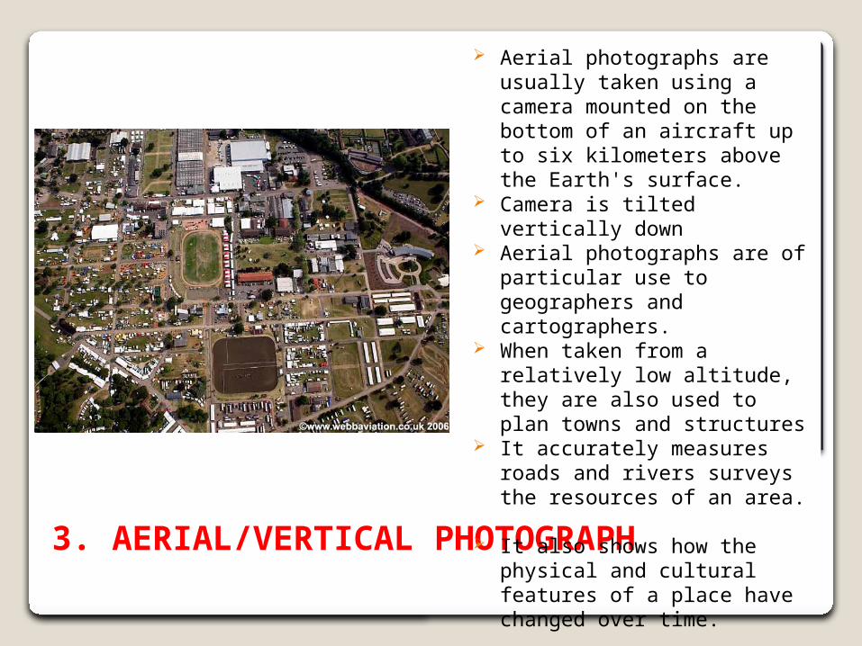
3. AERIAL/VERTICAL PHOTOGRAPH
Aerial photographs are usually taken using a camera mounted on the bottom of an aircraft up to six kilometers above the Earth's surface.
Camera is tilted vertically down Aerial photographs are of particular
use to geographers and cartographers.
When taken from a relatively low altitude, they are also used to plan towns and structures
It accurately measures roads and rivers surveys the resources of an area.
It also shows how the physical and cultural features of a place have changed over time.
Aerial photographs
Advantages of Aerial photographs
An aerial photograph enables the whole of an area to be observed, rather than just a portion of it.
The scale of an aerial photograph is relatively consistent throughout the entire frame. This enables accurate measurements to be made using photographs taken from this vertical view.
Disadvantages of Aerial photographs
The point of view is unfamiliar and most features look very different when viewed from above.
It is very difficult to recognise ground features.


