Page 1
Types of Spatial Data Sites
• Data portals: Find and download data– Humboldt County, National Atlas
• “Atlases”: General information– GoogleMaps, MapQuest
• Cartographic: Look cool– Wind map
• Spatial Web Applications: Targeted, provide information in spatial form– Sea level rise
Page 2
Types of Web Maps
• Static Maps (don’t move)
• Dynamic maps: zoom and pan
• Interactive maps: something happens when the user clicks on the map
• “Configurable”?– Allows user to change the layers
• 3D: Sorry, Google just canceled this– 3D “APIs” may appear in the future
Page 3
What do user’s need?
Page 4
Technology Needs
• Get raster and vector data from the server to the client as needed– Display for the user
• Respond to user requests for information– Balloons popup when the user clicks– Change layers, charts, etc. on clicks
Page 5
HTML 5 Game Changer
• Canvas element allows vector drawing in the browser
• Before this we had to:– Draw using “div” elements (little squares)
• Really complex and slow
– Pre-create tiles on the server
• Now:– We can draw!– http://www.w3schools.com/html/html5_canva
s.asp
Page 6
Definitions• Library - a collection of functions you can use
• API – application programming interface– How a programming language can “call” a library
of functions– “alert()” is part of the API for a browser– “getElementByID()” is part of the DOM API
• There are APIs for:– GoogleMaps– MapQuest– Weather services– Etc.
Page 7
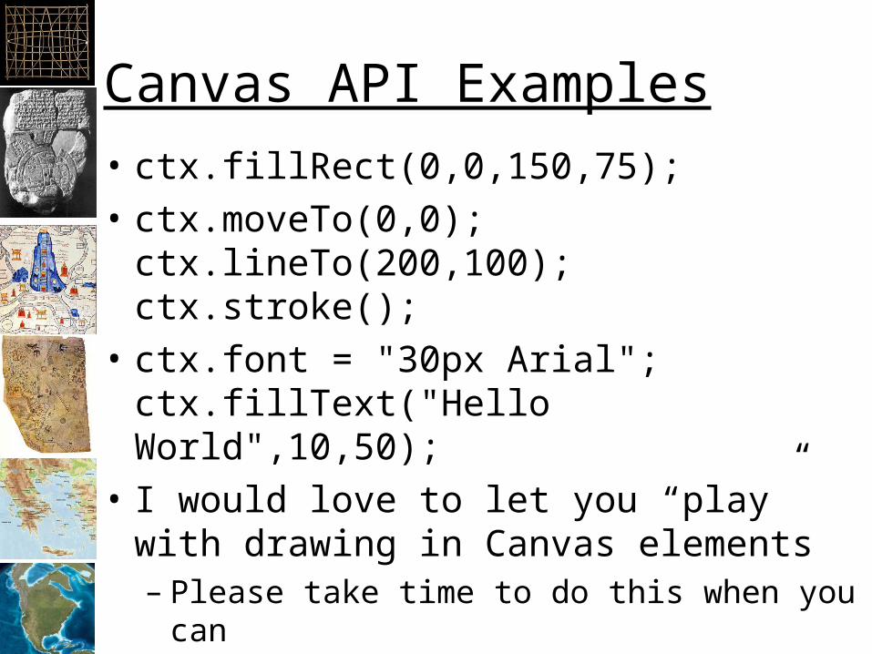
Canvas API Examples
• ctx.fillRect(0,0,150,75);
• ctx.moveTo(0,0);ctx.lineTo(200,100);ctx.stroke();
• ctx.font = "30px Arial";ctx.fillText("Hello World",10,50);
• I would love to let you “play” with drawing in Canvas elements– Please take time to do this when you can
Page 8
GIS Web Servers
Browser
Client Server
Web Server
HTML File
Image File
HTML File
Image File
Internet
URL
GeoJSON FilesJavaScript
Tile Server
Vector Data
Backgrounds (raster)Library
AJAX
Page 9
Technologies• JavaScript
– Much faster than expected
• AJAX: Asynchronous JavaScript and XML– Allow data to move from the server to
JavaScript
• GeoJSON: Geographic JavaScript Object Notation– Allows vector data to move from server to client
• The DOM– Canvas Objects
Page 10
Map Apps
• Problem: The libraries have not kept up– MapLayers: Maybe?– Leaflet: Still DIV based– MapBox: Cool but proprietary– Others are way behind
• CanvasMap: brand new– “Small” JavaScript library– Allows for:
• Full-feature default installation• High levels of customization
Page 11
GIS Web Servers
Browser
Client Server
Web Server
HTML File
Image File
HTML File
Image File
Internet
URL
GeoJSON FilesJavaScript
Tile Server
Vector Data
Backgrounds (raster)CanvasMap
AJAX
Page 12
How It Works
• Create a web page that includes:– The CanvasMap files– A “canvas” element
• Create vector data sets from Shapefiles:– Add the attributes you want to appear in the
map (e.g. HTML for a balloon)– Project the data to GoogleMaps (BlueSpray)– Save the data to GeoJSON
• Setup and start the CanvasMap map– Add you layers and specify attributes