UNCLASSIFIED Distribution authorized to US Government agencies and their contractors. UNCLASSIFIED (U) Improved Fusion Algorithm System John Merrihew Thomas Bevan, Ph.D. June 2016 (U) 1.0 Summary The objective of the Improved Fusion Algorithm System (IFAS) technology demonstration program is to develop advanced stochastic risk assessment technologies for information fusion in Associate Systems. The program is in Phase II of am OSD SBIR and has developed approaches for detecting and localizing OPFOR Tactics, Techniques and Procedures (TTPs) such as IED emplacement, VBIED emplacement, Ambush and Complex Attacks. IFAS fuses data from several sources including GMTI, GMTI MASINT, text reports and chat room conversations. IFAS demonstration systems have successfully yielded quantified risk assessment fusion that was both transparent and understandable for the operator. (U) 1.1 Abstract The objective of the Improved Fusion Algorithm System (IFAS) technology demonstration is to develop approaches to apply advanced stochastic risk assessment technologies that are currently in use in the financial industry by embedding them in an Associate System. The IFAS demonstrations combined Associate System technology that already had a robust topological GUI and net-centric presence with advanced statistical methods. The selected application involved risk assessments for OPFOR insurgent emplacement of Improvised Explosive Devices (IED), Vehicle Borne Improvised Explosive Devices (VBIED) and Ambushes as well as to provide a forensics capability for tracking IED triggermen and observers in the OPFOR IED cell. Interactive Associate Systems have been used to support human military decision makers in many contexts (e.g. pilots associate) but until now Associate Systems did not provide a quantified expression of risk to the operator based on objective data. An Associate System is a knowledge-based artificial intelligence system that analyzes data available to the operator and makes recommendations as to alternative courses of action. Veloxiti had previously developed an existing Associate System for Army units which provided a GUI which displayed an Area of Interest and could display net-centric information such as the monitoring of key words from chat rooms, and the position and disposition of ground and air assets. The financial industry has developed stochastic statistics to calculate the risk of loss from holding securities or holding a particular portfolio. The most advanced statistical approaches calculate “Conditional Value at Risk” (CVAR). The IFAS demonstration was intended to adapt these advanced statistical approaches for risk assessment in order to support the military operator. IFAS provides the capability to analyze large amounts of Ground Moving Target Indication Radar data and fuse it with other data. This would be tedious task for the human operator. GMTI data is used to track known insurgents as well as to perform
Transcript
UNCLASSIFIED Distribution authorized to US Government
agencies and their contractors.
UNCLASSIFIED
(U) Improved Fusion Algorithm System
John Merrihew
Thomas Bevan, Ph.D.
June 2016
(U) 1.0 Summary The objective of the Improved Fusion Algorithm System (IFAS) technology
demonstration program is to develop advanced stochastic risk assessment technologies
for information fusion in Associate Systems. The program is in Phase II of am OSD
SBIR and has developed approaches for detecting and localizing OPFOR Tactics,
Techniques and Procedures (TTPs) such as IED emplacement, VBIED emplacement,
Ambush and Complex Attacks. IFAS fuses data from several sources including GMTI,
GMTI MASINT, text reports and chat room conversations. IFAS demonstration systems
have successfully yielded quantified risk assessment fusion that was both transparent and
understandable for the operator.
(U) 1.1 Abstract
The objective of the Improved Fusion Algorithm System (IFAS) technology
demonstration is to develop approaches to apply advanced stochastic risk assessment
technologies that are currently in use in the financial industry by embedding them in an
Associate System. The IFAS demonstrations combined Associate System technology
that already had a robust topological GUI and net-centric presence with advanced
statistical methods. The selected application involved risk assessments for OPFOR
insurgent emplacement of Improvised Explosive Devices (IED), Vehicle Borne
Improvised Explosive Devices (VBIED) and Ambushes as well as to provide a forensics
capability for tracking IED triggermen and observers in the OPFOR IED cell. Interactive
Associate Systems have been used to support human military decision makers in many
contexts (e.g. pilots associate) but until now Associate Systems did not provide a
quantified expression of risk to the operator based on objective data. An Associate
System is a knowledge-based artificial intelligence system that analyzes data available to
the operator and makes recommendations as to alternative courses of action. Veloxiti had
previously developed an existing Associate System for Army units which provided a GUI
which displayed an Area of Interest and could display net-centric information such as the
monitoring of key words from chat rooms, and the position and disposition of ground and
air assets.
The financial industry has developed stochastic statistics to calculate the risk of
loss from holding securities or holding a particular portfolio. The most advanced
statistical approaches calculate “Conditional Value at Risk” (CVAR). The IFAS
demonstration was intended to adapt these advanced statistical approaches for risk
assessment in order to support the military operator.
IFAS provides the capability to analyze large amounts of Ground Moving Target
Indication Radar data and fuse it with other data. This would be tedious task for the
human operator. GMTI data is used to track known insurgents as well as to perform
UNCLASSIFIED Distribution authorized to US Government
agencies and their contractors.
UNCLASSIFIED
MASINT analysis of speed and direction. The quantified risk and location of OPFOR
Tactics, Techniques and Procedures (TTP) is conveyed to the operator in a way that
provides transparency and understandability. Rather than use statistics variables which
are hard to intuit, a 0-200 risk assessment is provided. Transparency and
understandability are important in order for the operator to accept and have confidence
the Associate System and the algorithm results. Likewise, the risk that moving vehicles
contained triggermen or observers in the OPFOR IED cell is calculated based on distance
from the IED blast and the time since the IED blast. The CVAR risk statistics is added
together to provide a risk assessment. The risk for each vehicle is conveyed to the
operator.
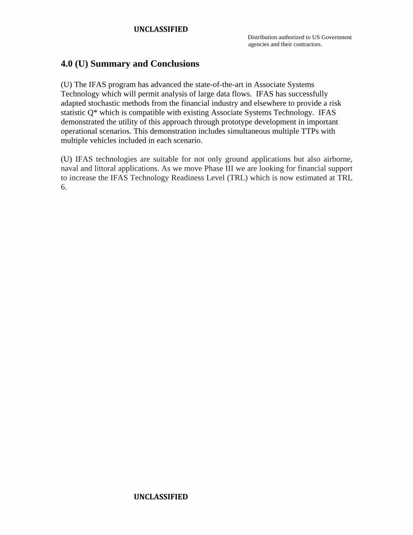
IFAS technologies are suitable for not only ground applications but also airborne,
naval and littoral applications. As we move Phase III we are looking for support to
increase IFAS Technology Readiness Level (TRL) which is now estimated at TRL 6.
2.0 (U) Introduction and Objectives (U) Improvements in remote sensing technology and the increase in remote sensing
platforms have drastically increased data flows within the net centric system. These data
flows contain important operational risk information but the data far exceeds the human
capability to extract this risk information in near real time. Having the capability to
analyze these data flows would increase the operational utility of the sensor collections.
(U) In particular, ground moving target radar (GMTI) data is collected nearly
continuously across the battlefield. The primary JSTARS system has been augmented
with GMTI sensors operating various aircraft and on drone platforms. Data from GMTI
systems are used for such tasks as convoy oversight but most of the data cannot be
analyzed because of its volume. GMTI corellators are in development to provide data
streams that include all of the GMTI assets. These corellators also deconflict and track
detected target vehicle.
(U) The United States military is engaged in conflicts with insurgents in many areas
of the world. Indications are that the U.S. will have to deal with insurgent warfare into
the foreseeable future. For this reason, near real time detection and alerting of insurgent
TTPs (techniques, tactics and procedures) is of interest. Typical insurgent TTPs include
improvised explosive devices (IED) used for roadside attack, ambushes and vehicle borne
improvised explosive devices (VBIED). There are several common ambush formations
which are taught by the world’s military and used by insurgents. The V formation is the
most common with the apex of the V pointing towards direction of travel. This formation
allows vehicles and personnel to be blocked by the apex of the V with good fields of fire
for attackers. Also of interest are warnings of complex attacks that, for example, involve
both ambush and VBIED. In this case the VBIED is positioned near the apex of the V to
destroy or disable friendly vehicles that also block the direction of travel.
(U) In addition to the need for near real time warnings of insurgent TTPs, U.S. forces
would also like to improve forensics analysis which seeks to track attackers as they flee
UNCLASSIFIED Distribution authorized to US Government
agencies and their contractors.
UNCLASSIFIED
from engagements. This is particularly important for insurgent attackers because they
can otherwise melt back into the local population. Some non-real time GMTI forensics
is currently conducted, but it is time consuming and takes several months for results. By
that time, attackers may have moved to other areas or other safe houses.
(U) Associate Systems Technology (AST) was developed to aid pilots to deal with the
large dataflows on modern combat aircraft. The technology can analyze available data to
provide users with findings and recommendations on alternative courses of action. For
this reason application of Associate Systems Technology could be a valuable asset to
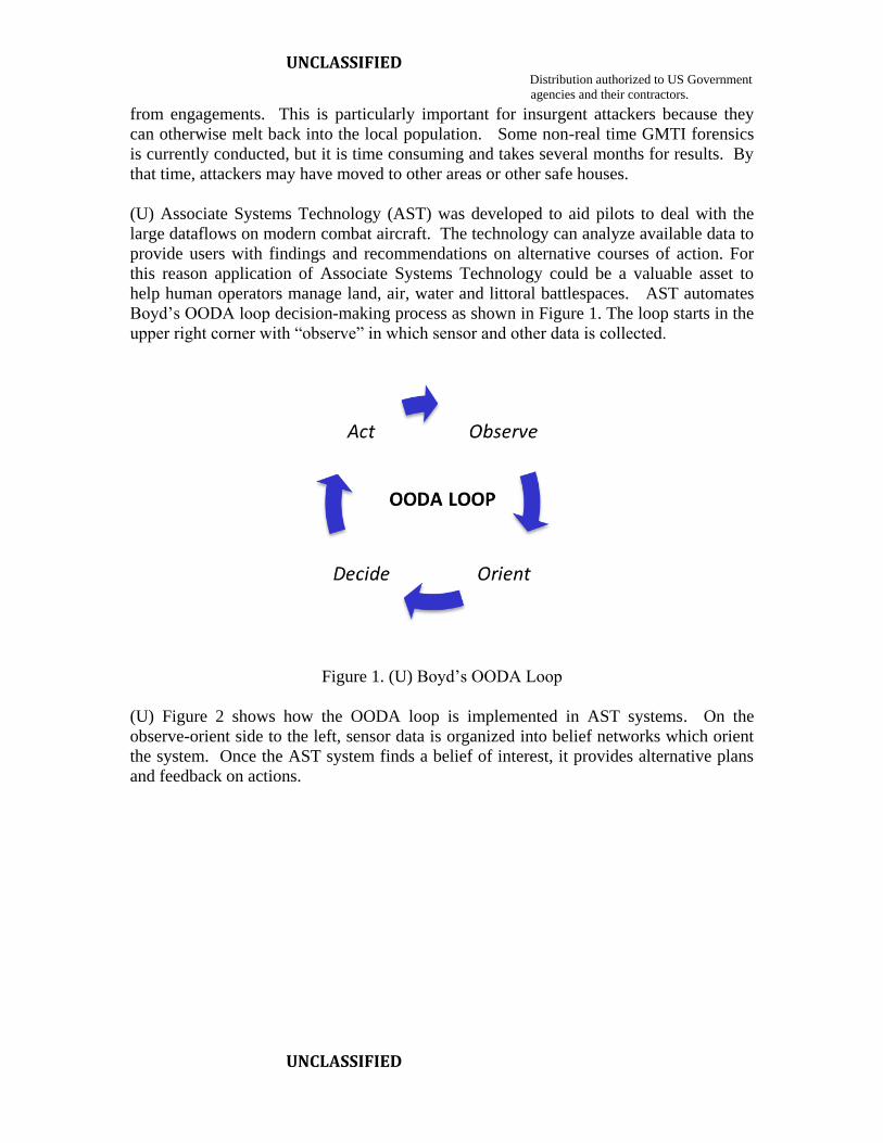
help human operators manage land, air, water and littoral battlespaces. AST automates
Boyd’s OODA loop decision-making process as shown in Figure 1. The loop starts in the
upper right corner with “observe” in which sensor and other data is collected.
Figure 1. (U) Boyd’s OODA Loop
(U) Figure 2 shows how the OODA loop is implemented in AST systems. On the
observe-orient side to the left, sensor data is organized into belief networks which orient
the system. Once the AST system finds a belief of interest, it provides alternative plans
and feedback on actions.
UNCLASSIFIED Distribution authorized to US Government
agencies and their contractors.
UNCLASSIFIED
Figure 2. (U) Implementation of Boy’s OODA loop in Associate Technology Systems
(U) The technical objectives of the IFAS Program are two fold:
Adapt stochastic methods to AST belief networks.
Demonstrate GMTI MASINT detection of insurgent TTP and forensics.
(U) Prior to IFAS, Associate Systems Technology based its belief and decision networks
on subjective opinion, whether through deterministic or Bayesian links. The goal of the
IFAS program was to adapt stochastic techniques to be used in AST networks.
Specifically, statistical approaches that have been developed in the financial industry to
assess stock price and portfolio risk to assess the risk of TTP. The stochastic approach
from the financial industry that was used is called Conditional Value at Risk or CVAR.
CVAR statistics are particularly useful for assessing values at the extremes of stock price
distributions as shown in Figure 3. This figure shows the difference between two
distributions (normal, t-distribution). The values of percentiles at the tails are sensitive to
the exact distribution involved. The IFAS program developed a statistic called Q* which
is the reciprocal of the observed percentile. This provides a useful statistic which
increases with risk and has other useful properties. For example, to adapt CVAR to
GMTI vehicle speed data where very slow vehicles may be carrying IED munitions, we
calculated the Q* score for the percentile of the observed value. As the speed of the
vehicle decreased, the risk of that vehicle carrying IED munitions decreased in terms of
Q* score.
UNCLASSIFIED Distribution authorized to US Government
agencies and their contractors.
UNCLASSIFIED
Figure 3. (U) Importance of CVAR for Distribution Tails.
Figure 4 summarizes the useful properties of CVAR for AST.
Figure 4. (U) Summary of CVAR Advantages
UNCLASSIFIED Distribution authorized to US Government
agencies and their contractors.
UNCLASSIFIED
The objective of the IFAS program was to demonstrate that stochastic methods could be
integrated into AST to conduct MASINT analysis of GMTI data. The goal was to use
stochastic methods to analyze speed, direction and position of vehicles as detected by
GMTI. These methods were used to detect IED, ambush, VBIED and complex attack
TTPs as well as to provide forensics intelligence. An IFAS prototype was developed and
demonstrated in two scenarios involving these TTPs. This adaptation of stochastic
methods for AST.
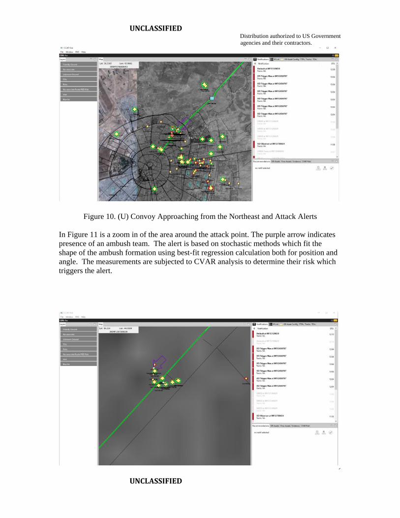
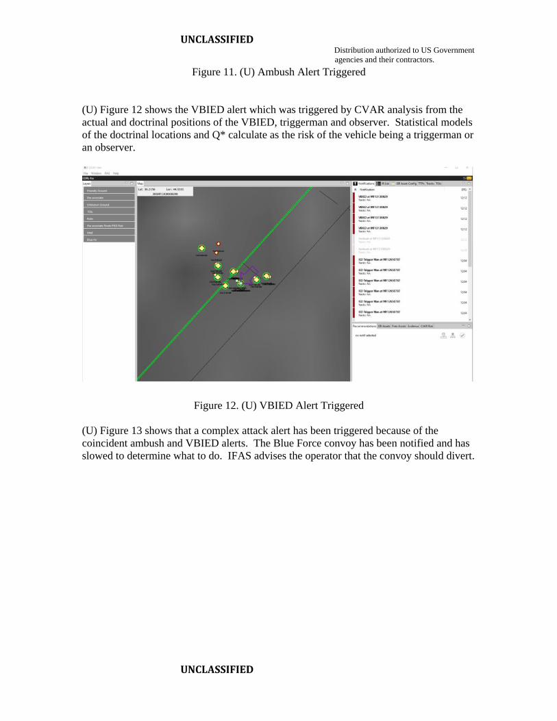
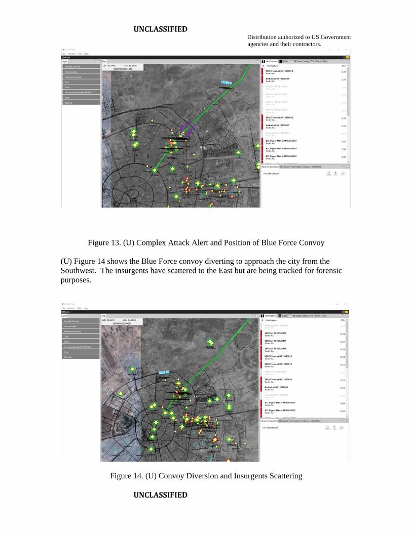
3.0 (U) Scenario Demonstrations
(U) In Phase I of the IFAS SBIR Phase II a prototype was constructed and demonstrated
on two scenarios so far. A third scenario on patterns of life is in progress. The two
scenarios are:
1. IED Emplacement Detection
2. Ambush, VBIED and Complex Attack Detection
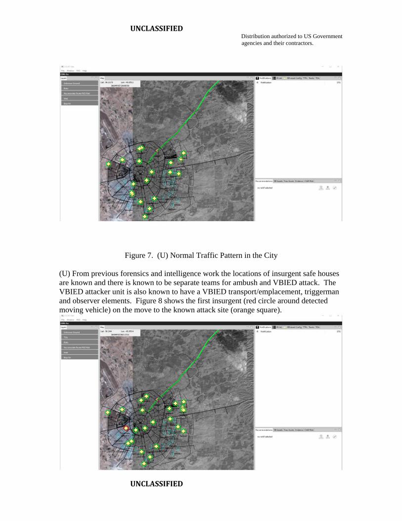
3.1 (U) Scenario 1: IED Emplacement Detection
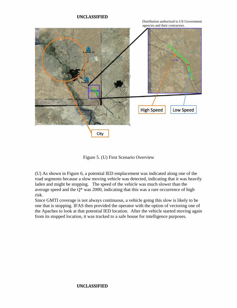
(U) This scenario involved detection of the emplacement of IEDs along roads which is a
common insurgent TTP. As shown in Figure 5, the scenario involved two road segments
where IEDs have frequently been planted. A distribution of vehicle speeds was
constructed using research findings indicating that they tend to be normally distributed.
One was a low speed average segment and one a high-speed segment. Apache
helicopters were on routing patrol in the area.
UNCLASSIFIED Distribution authorized to US Government
agencies and their contractors.
UNCLASSIFIED
Figure 5. (U) First Scenario Overview
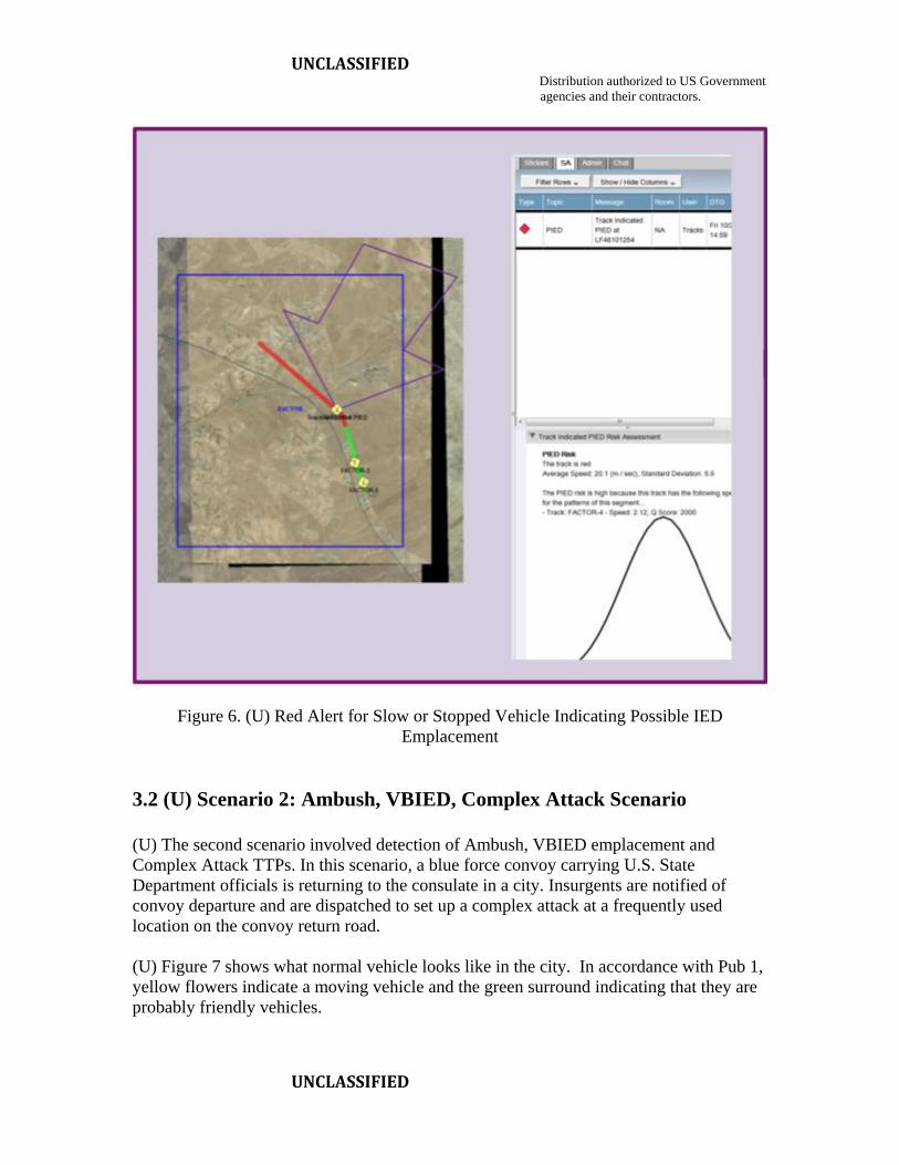
(U) As shown in Figure 6, a potential IED emplacement was indicated along one of the
road segments because a slow moving vehicle was detected, indicating that it was heavily
laden and might be stopping. The speed of the vehicle was much slower than the
average speed and the Q* was 2000, indicating that this was a rare occurrence of high
risk.
Since GMTI coverage is not always continuous, a vehicle going this slow is likely to be
one that is stopping. IFAS then provided the operator with the option of vectoring one of
the Apaches to look at that potential IED location. After the vehicle started moving again
from its stopped location, it was tracked to a safe house for intelligence purposes.
UNCLASSIFIED Distribution authorized to US Government
agencies and their contractors.
UNCLASSIFIED
Figure 6. (U) Red Alert for Slow or Stopped Vehicle Indicating Possible IED