ZEUS PETROLEUM LIMITED P.1393 Relinquishment Report October 2009 Page 1 RELINQUISHMENT REPORT FOR P.1393; BLOCKS 12/15, 13/11, 13/12 & 13/13 Licence: P.1393 Blocks: 12/15, 13/11, 13/12 & 13/13 23rd Round Promote Licence Operator: Zeus Petroleum Ltd. 100% Work Programme Summary: Acquire and interpret 760km 2D seismic data. Construct a tectonostratigraphic framework of the Jurassic in the licensed area (Promote). Fulfilled. Acquire 1700 km high resolution 2D seismic with pseudo 3D processing -equivalent to 300 km2 3D (Extension period). Fulfilled (1849km full fold data acquired). Contingent well: Test Jurassic & Cretaceous targets to a depth of 3050m, contingent on; 1) Further analysis of the leads already identified to demonstrate the presence of a competent trapping mechanism (based on new seismic) and 2) The presence of any Direct Hydrocarbon Indicators on the above leads (based on the new seismic). Waived in view of absence of viable prospects in Blocks. SYNOPSIS Blocks 12/15, 13/11, 13/12, & 13/13 were awarded as Promote licence P 1393 to Wimbledon Oil & Gas Ltd, as part of the 23 rd round awards, in December 2005. Wimbledon was subsequently purchased by Zeus in September 2006. The blocks are located in a high risk, relatively under explored area of the Moray Firth (Wick Basin) and prior to the current licence being taken up, were covered by a loose grid of 2D seismic lines. The original application for the license was based on the identification of a number of conceptual leads in the primary Upper Jurassic and secondary Lower Cretaceous strata and Zeus latterly undertook to shoot a proprietary high resolution 2D seismic survey in conjunction with pseudo 3D processing (See Figure 1).
Transcript
ZEUS PETROLEUM LIMITED
P.1393 Relinquishment Report October 2009 Page 1
RELINQUISHMENT REPORT FOR P.1393;
BLOCKS 12/15, 13/11, 13/12 & 13/13
Licence: P.1393
Blocks: 12/15, 13/11, 13/12 & 13/13
23rd Round Promote Licence
Operator: Zeus Petroleum Ltd. 100%
Work Programme Summary: Acquire and interpret 760km 2D seismic data. Construct a
tectonostratigraphic framework of the Jurassic in the
licensed area (Promote). Fulfilled.
Acquire 1700 km high resolution 2D seismic with pseudo
3D processing -equivalent to 300 km2 3D (Extension
period). Fulfilled (1849km full fold data acquired).
Contingent well: Test Jurassic & Cretaceous targets to a
depth of 3050m, contingent on;
1) Further analysis of the leads already identified to
demonstrate the presence of a competent trapping
mechanism (based on new seismic) and
2) The presence of any Direct Hydrocarbon Indicators on
the above leads (based on the new seismic).
Waived in view of absence of viable prospects in Blocks.
SYNOPSIS
Blocks 12/15, 13/11, 13/12, & 13/13 were awarded as Promote licence P 1393 to Wimbledon Oil & Gas Ltd, as part of the 23rd round awards, in December 2005. Wimbledon was subsequently purchased by Zeus in September 2006.
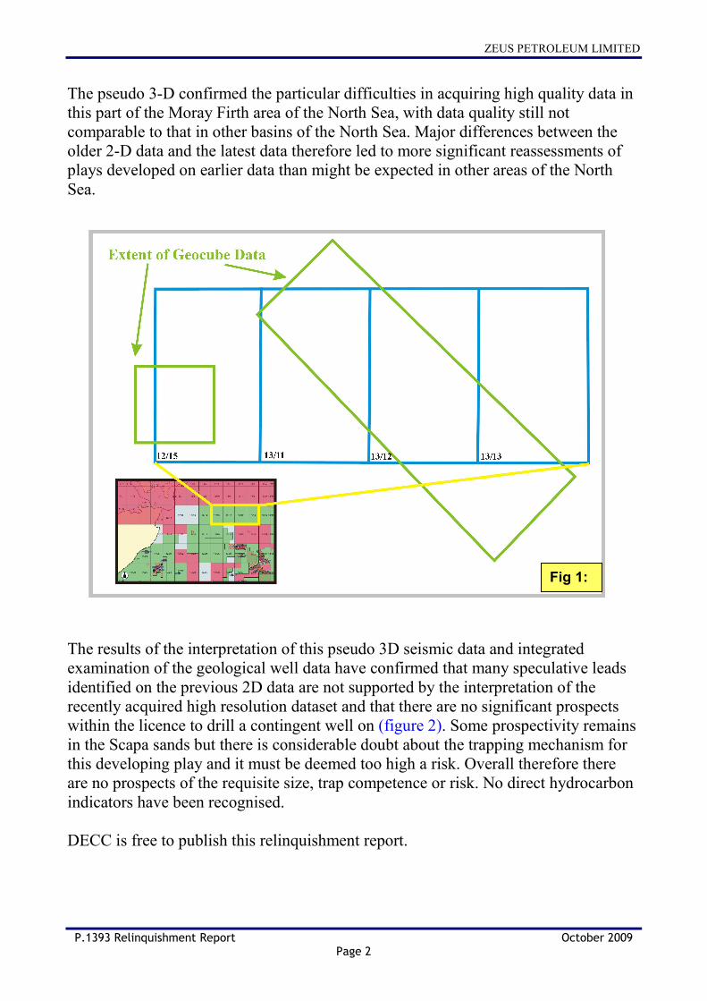
The blocks are located in a high risk, relatively under explored area of the Moray Firth (Wick Basin) and prior to the current licence being taken up, were covered by a loose grid of 2D seismic lines. The original application for the license was based on the identification of a number of conceptual leads in the primary Upper Jurassic and secondary Lower Cretaceous strata and Zeus latterly undertook to shoot a proprietary high resolution 2D seismic survey in conjunction with pseudo 3D processing (See Figure 1).
ZEUS PETROLEUM LIMITED
P.1393 Relinquishment Report October 2009 Page 2
The pseudo 3-D confirmed the particular difficulties in acquiring high quality data in this part of the Moray Firth area of the North Sea, with data quality still not comparable to that in other basins of the North Sea. Major differences between the older 2-D data and the latest data therefore led to more significant reassessments of plays developed on earlier data than might be expected in other areas of the North Sea. The results of the interpretation of this pseudo 3D seismic data and integrated examination of the geological well data have confirmed that many speculative leads identified on the previous 2D data are not supported by the interpretation of the recently acquired high resolution dataset and that there are no significant prospects within the licence to drill a contingent well on (figure 2). Some prospectivity remains in the Scapa sands but there is considerable doubt about the trapping mechanism for this developing play and it must be deemed too high a risk. Overall therefore there are no prospects of the requisite size, trap competence or risk. No direct hydrocarbon indicators have been recognised. DECC is free to publish this relinquishment report.
Fig 1:
ZEUS PETROLEUM LIMITED
P.1393 Relinquishment Report October 2009 Page 3
EXPLORATION ACTIVITIES In order to fulfill the initial work program, and to fully evaluate Blocks 12/15, 13/11, 13/12 and 13/13, a loose grid of 2D seismic was purchased and interpreted. Encouraged by the identification of conceptual leads at the Lower Cretaceous and Upper Jurassic levels on this 2D it was decided to shoot a new high resolution 2D seismic survey (with pseudo 3D processing) over the blocks to de-risk these leads. Zeus commissioned Fugro to acquire these data in 2008.
Data for 11 exploration wells were also purchased for this evaluation. Subsequently data were interpreted over the whole area, concentrating on the Lower Cretaceous Scapa and Upper Jurassic Teviot and Buzzard intervals. Interpretation has been
WICK BASIN
WICK BASIN
Fig 2:
ZEUS PETROLEUM LIMITED
P.1393 Relinquishment Report October 2009 Page 4
completed and has confirmed that there are no significant prospects to drill the Contingent well on. PROSPECTIVITY OF 12/15, 13/11, 13/12 & 13/13 The area of Blocks 12/15, 13/11, 13/12 and 13/13 largely covers an area known as the Wick Basin. The potential for a working petroleum system has been examined within the blocks. For this to be effective, hydrocarbons must be trapped in stratigraphic closures in both the Upper Jurassic and Lower Cretaceous sands, as there is no evidence of any significant, untested structural closures within the licence area. As part of a group in an adjacent licence, Zeus has undertaken regional source rock modelling using geochemical data from wells throughout the Inner and Outer Moray Firth. This demonstrates that Devonian source rocks entered the ‘oil window’ at around 4000 metres depth of burial in the Wick Basin. Similarly, the Upper Jurassic source rocks entered the oil window at around 3600 metres and a limited hydrocarbon kitchen can be mapped in the blocks at the base of the Upper Jurassic. Migrated hydrocarbon shows have been identified in wells drilled outside the licence area and on the periphery of the basin (12/14-1 to the west and 13/16-1 to the south). Despite this potential for hydrocarbon generation, neither wells which have been drilled in the licence and which penetrate the Devonian (13/11-1 and 13/12-1) encountered any hydrocarbon shows in the Devonian or Jurassic section. The conclusion from this evidence is that there is a restricted hydrocarbon kitchen within the Wick Basin and that any generated hydrocarbons may have migrated outside of the licence area. In addition, the new data confirms that the main NW-SE Little Halibut Fault to the east of the Wick Basin and which runs through blocks 13/11 & 12, has been reactivated many times with evidence of disturbances up to the sea-bed. Therefore, this provides the potential for a direct hydrocarbon conduit right through to the surface in this direction, limiting the potential for hydrocarbon migration into the eastern part of the licence. Mapping of the Upper Jurassic and Lower Cretaceous events provide evidence of a series of sands which have the potential to form stratigraphic traps if encapsulated in sealing shale. Although the wells in this area show that good quality reservoir sands are abundant there is limited evidence of effective lateral seal and thus any stratigraphic trapping mechanism remains highly uncertain. Well 13/11-1 tested the Upper Jurassic Volgian section and demonstrated the presence of significant sands but due to the absence of any shows there is no evidence that hydrocarbons reached this area. The recent seismic data has helped to define a potential Lower Cretaceous ‘Scapa’ package in 13/11, which does not continue along the major fault into 13/12 as
ZEUS PETROLEUM LIMITED
P.1393 Relinquishment Report October 2009 Page 5
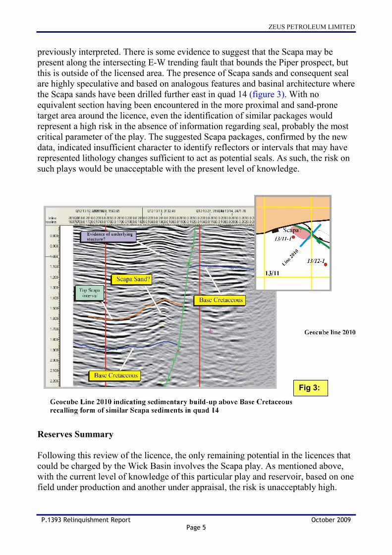
previously interpreted. There is some evidence to suggest that the Scapa may be present along the intersecting E-W trending fault that bounds the Piper prospect, but this is outside of the licensed area. The presence of Scapa sands and consequent seal are highly speculative and based on analogous features and basinal architecture where the Scapa sands have been drilled further east in quad 14 (figure 3). With no equivalent section having been encountered in the more proximal and sand-prone target area around the licence, even the identification of similar packages would represent a high risk in the absence of information regarding seal, probably the most critical parameter of the play. The suggested Scapa packages, confirmed by the new data, indicated insufficient character to identify reflectors or intervals that may have represented lithology changes sufficient to act as potential seals. As such, the risk on such plays would be unacceptable with the present level of knowledge. Reserves Summary Following this review of the licence, the only remaining potential in the licences that could be charged by the Wick Basin involves the Scapa play. As mentioned above, with the current level of knowledge of this particular play and reservoir, based on one field under production and another under appraisal, the risk is unacceptably high.
Fig 3:
ZEUS PETROLEUM LIMITED
P.1393 Relinquishment Report October 2009 Page 6
Scapa Lead
Type: Stratigraphic pinchout at near BCU level against the Little Halibut Fault.
Risks: • Structure: Defined by pseudo 3D seismic. Risk of structure is moderate but there are significant uncertainties on GRV. (0.6)
• Source/Migration: Restricted Kitchen in Block 13/11. Oil shows have not been recognised in nearby wells – maybe not on migration pathway. Risk of suitable source and migration path is moderate to high. (0.5)
• Seal: Lead is likely to leak if there is connectivity to sands higher in the section. The trap is stratigraphic and there is a significant risk on top seal at the location. Seal risk is high. (0.2)
• Reservoir: Lower Cretaceous Scapa sediments are postulated within the mapped seismic package. Not identified in nearby wells. Reservoir risk is moderate to high. (0.3)