UMATILLA RIVER BASIN ANADROMUS FISH HABITAT ENHANCEMENT PROJECT 1994 ANNUAL REPORT Prepared by: R. Todd Shaw Confederated Tribes of the Umatilla Indian Reservation Department of Natural Resources Fisheries Program Prepared for: U S. Department of Energy Bonneville Power Administration Environment, Fish and Wildlife P.O. Box 3621 Portland, OR 97208-362 1 Project No. 87- 100-O 1 Contract No. DE-BI79-87BP35768 May 1994
Transcript
UMATILLA RIVER BASIN ANADROMUS FISH HABITATENHANCEMENT PROJECT
1994 ANNUAL REPORT
Prepared by:
R. Todd Shaw
Confederated Tribes of the Umatilla Indian ReservationDepartment of Natural Resources
Fisheries Program
Prepared for:
U S. Department of EnergyBonneville Power AdministrationEnvironment, Fish and Wildlife
The Umatilla Basin Anadromous Fish Habitat Enhancement Project is funded under theNorthwest Power Planning Council’s Columbia River Basin Fish and Wildlife Program, Section7.6 - 7.8 and targets the improvement of water quality and restoration of riparian areas,holding, spawning and rearing habitats of steelhead, spring and fall chinook and coho salmon.
The project focused on implementing cooperative instream and riparian habitat improvementson private lands on the Umatilla Indian Reservation (hereafter referred to as Reservation) fromApril 1, 1988 to March 31, 1992. These efforts resulted in enhancement of the lower l/4 mileof Boston Canyon Creek, the lower 4 river miles of Meacham Creek and 3.2 river miles of theUmatilla River in the vicinity of Gibbon, Oregon. In 1993, the project shifted emphasis to acomprehensive watershed approach, consistent with other basin efforts, and began to identifyupland and riparian watershed-wide causative factors impacting fisheries habitat and naturalfisheries production capabilities throughout the Umatilla River Watershed. During the 1994 - 95project period, a one river mile demonstration project was implemented on two privately ownedproperties on Wildhorse Creek. This was the first watershed improvement project to beimplemented by the Confederated Tribes of the Umatilla Indian Reservation (CTUIR) off of theReservation.
Four 15 year riparian easements and two right-of-way agreements were secured forenhancement of one river mile on Wildhorse Creek and l/2 river mile on Meacham Creek.Enhancements implemented between river mile (RM) 9.5 and RM 10.5 Wildhorse Creek included:1) installation of 1.43 miles of smooth wire high tensile fence line and placement of 0.43 milesof fence posts and structures to restrict livestock from the riparian corridor, 2) construction ofeighteen sediment retention structures in the stream channel to speed riparian recovery byelevating the stream grade, slowing water velocities and depositing sediments onto streambanksto provide substrate for revegetation, and 3) revegetation of the stream corridor, terraces andadjacent pasture areas with 644 pounds of native grass seed (when commercially available) orclose species equivalents and 4,000 native riparian shrub/tree species to assist in floodplainrecovery, stream channel stability and filtering of sediments during high flow periods. Threehundred pounds of native grass/legume seed (including other grasses/legumes exhibiting nativespecies characteristics) were broadcast in existing Boston Canyon Creek, Meacham Creek andUmatilla River project areas. The addition of two properties into the project area between RM4.25 and RM 4.75 Meacham Creek during the 1995 - 96 work period will provide nearly completeproject coverage of lower Meacham Creek corridor areas on the Reservation.
Water quality monitoring continued for temperature and turbidity throughout the upperUmatilla River Watershed. Survey of cross sections and photo documentation of riparianrecovery within the project areas provided additional baseline data.
Physical habitat surveys continued to be conducted to characterize habitat quality and toquantify various habitat types by area. This information will be utilized to assist in identificationof habitat deficient areas within the watershed in which to focus habitat restoration efforts.
These ef‘forts were coordinated with the CXJIR Umatilla Basin Natural Production Monitoringand Evaluation (1JBNPME) Project.
Poor land use practices, which 11ave altered natural floodplain dynamics and significantlyreduced or eliminated fisheries hablt;it, continued to be IdentifLed in the Mission Creek Subbasin.Complied data is currently being incorporated into a data layer for a Geographic InformationSystem (GIS) data base. This cf‘fort is being coordinated wit!1 the Natural Resource ConservationService (NRCS).
Community outreach efrorts and pubiic education opportunities continued during the reportingperiod. CTUIR cooperatively spcln5ored a bioengineermg worlkshop on February 23, 1995 withthe Oregon Department of F!sl: and Wildlife (ODFW). This workshop attracted a combined total3f over 270 participants at day and evening sessions.
ii
ACKNOWLEDGMENTS
This project was funded by the Bonneville Power Administration. The Confederated Tribes of theUmatilla Indian Reservation thank Jerry Bauer and other Bonneville Power Administrationpersonnel for their assistance. Thanks also to Jerry Lauer of the Bureau of Indian Affairs, TimBailey and Troy Laws of the Oregon Department of Fish & Wildlife, Ed Calame of the UmatillaNational Forest, Bob Adelman, Lisa Greber and Stephen Caruana of the Natural ResourceConservation Service and Jim Loiland of Grassland West Seed Company for technical input andassistance.
We would like to acknowledge cooperating landowners, Bud Schmidtgall, Terry Schmidtgall, BobMiller. Janet Miller, Lynn Walker, Virginia Whitacre, Sam Haynes, Frances Myers, Merna Tovey,Emmet Williams, Fawn Williams, Kathy Williams, Cecelia Bearchum, Brenda Bearchum, TheresaJohnson and Eleanor Home, who supported our efforts and provided important backgroundinformation on their properties in the project areas.
Thanks also to Confederated Tribes of the Umatilla Indian Reservation staff, whose cooperationand contributions are evident in this report. Special thanks to Ken Hall, David Wolf, Louis Caseand Troy Rodriguez for the iong hours performing office duties, monitoring habitatenhancements, and implementing and maintaining improvements in project areas, to AaronSkirvin for assistance with MissIon Creek Watershed planning and development, to MichaelPurser for sharing his knowledge of non-point source pollution impacts, to Janet Ebaugh forbotarncal expertise, to Julie A. Burke and Celeste Reeves for secretarial services and publicrelations preparations, to Michael Farrow, Carl Scheeler and Gary James for their optimism,support and guidance, to Joe Richards for administration of this agreement.
Last, but not least, we wash to thank the Confederated Tribes of the Umatilla Indian ReservationSalmon Corps participants, Blue Mountain Chapter of Trout Unlimited, the Umatilla BasinWatershed Council and other volunteers who assisted in planting 4,000 trees along WildhorseCreek during the fall of 1994 and spring of 1995.
3. Post-construction Activities and Habitat Enhancement Monitoringa. Post-construction Final Review . . . . . . . . . . . . . . . . . . . . . . . . . . 10b. Transect Measurements and Photo Point Monitoring . . . . . . , . . . . 10C. Physical Condition of Improvements and General Stream Hydraulics 11
Objective II. Collect Baseline Water Quality Data and Continue Post-project Monitoring toIdentify Watershed Health Concerns and to Quantify the Short and Long-TermEffects of Habitat Enhancement Activities in the Umatilla River Basin.
Objective III. Continue Watershed Planning/Scoping/Education Process by Identifying Problemsand Developing Creative Solutions to Land Use Problems Impacting FisheriesHabitat in the Umatilla River Basin.
3. Post-construction Activities and Habitat Enhancement Monitoringa. Post-construction Final Review . . . . . . . . . . . . . . . . . . . . . . . . . . . 23b. Transect Measurements and Photo Point Monitoring . . . . . . . . . . . 23C. Physical Condition of Improvements and General Stream Hydraulics 24
Objective II. Collect Baseline Water Quality Data and Continue Post-project Monitoring toIdentify Watershed Health Concerns and to Quantify the Short and Long-TermEffects of Habitat Enhancement Activities in the Umatilla River Basin.
Continue Watershed Planning/Scoping/Education Process by Identifying Problemsand Developing Creative Solutions to Land Use Problems Impacting FisheriesHabitat in the Umatilla River Basin.
Pursue Alternative Management Methods to Mitigate Impacts from Past andOngoing Land Management Activities
Appendix A - Water Temperature Graphs . . . , . . . . . . . . . . . . . . . . . . . . . . . . . . . . . .A-l. Umatilla River - River Mile 56 (West Reservation Boundary)A-2. Umatilla River - River Mile 78.5 (Downstream Mouth of Meacham Creek)A-3. Umatilla River - River Mile 79 (Upstream Mouth of Meacham Creek)A-4. Umatilla River - River Mile 81.7 (USGS Gage Station No. 14020000)A-5. Wildhorse Creek - River Mile 0 (Confluence with Umatilla River)A-6. Wildhorse Creek - River Mile 26A-7. Buckaroo Creek - River Mile 2A-8. Squaw Creek - River Mile 2A-9. Squaw Creek - River Mile 9 (Confluence with Little Squaw Creek)A-10. Meacham Creek - River Mile 2 (USGS Gage Station No. 14020300)A-11. Meacham Creek - River Mile 5.25 (East Reservation Boundary)
Appendix B - Suspended Sediment Graphs . . . . . . . . . . . . . . . . . . . . . . . . . . . . . . . . .B-l. Umatilla River - River Mile 56B-2. Umatilla River - River Mile 81.7 (USGS Gage Station No. 14020000)B-3. Meacham Creek - River Mile 2 (USGS Gage Station No. 14020300)
Appendix C - News Articles, CTUIR Habitat Enhancement Efforts
3. Suspended Sediment Monitoring Sites for the 1994 Annual Year . . . . . . . . . . . . . 14
Vlll
INTRODUCTION
This Umatilla River Basin Anadromous Fish Habitat Enhancement Project Report covers workaccomplished by the Confederated Tribes of the Umatilla Indian Reservation (CTUIR) from May1, 1994 through April 30, 1995 as part of the Umatilla Basin Fisheries Restoration Program. Thisproject is funded under the Northwest Power Planning Council’s Columbia Basin Fish andWildlife Program, Section 7.6 - 7.8 to partially mitigate for losses of salmon and steelheadpopulations in the Columbia River Basin from the construction and operation of hydroelectricdams.
Significant effort and funds have been directed at restoration of anadromous fish in the UmatillaRiver Basin. This habitat project is one element in the comprehensive Umatilla Basin FisheriesRestoration Program which also includes artificial production, adult and juvenile passageimprovements (ladders, screens and trap and haul), instream flow enhancement and monitoringand evaluation. Emphasis on watershed-wide habitat is needed for protection and enhancementof the natural production capabilities in the basin.
The primary problems continuing to impact water quality and limit available habitat and naturalfisheries production capabilities in the Umatilla River Basin include: non-point source pollutiondue to poor cropland tillage and rotation practices, livestock overgrazing riparian and uplanddress, over appropriation of necessary instream flows to irrigators, and stream channelization,constriction, and floodplain modification from agricultural and road/railroad building andmaintenance activities.
The project represents a continuation and evolution of existing efforts to improve naturalproduction in the Umatilla River Basin. The goal of this project is to enhance natural productionof existing summer steelhead and re-introduced chinook and coho salmon in the Umatilla RiverBasin. Land use practices in the watershed and existing fish and riparian habitats are beinganalyzed to identify and address the watershed-wide causative factors to reduced fish productioncapability. The project will continue to provide critical elements to a comprehensive watershedmanagement approach to help guide implementing agencies and CTUIR in promotinganadrcmous fish rebuilding plans, and recommend necessary changes to management systems.
Technical integration and coordination is being provided by utilizing a GIS data base for suchcomponents as habitat condit:,on, land ownership, land use, ecotype and proposedmanagement/restoration actions. The project complements ongoing fish passage and artificialproduction projects already in place in the basin and will integrate existing on-the-groundmanagement systems and programs on private and public lands with restoration activities tobetter justify expenditure of funds and time. Stream habitat surveys, summaries of existingsurvey information and follow up surveys are coordinated with CTUIR’s UBNPME Project.Remedial measures will be implemented to reduce or eliminate detrimental land use activitieswhere possible. Continued operations and maintenance of- existing enhancement projects areincluded under this integrated approach.
The restoration of anadromous fisheries resources in the Umatilla River Basin has been acoordinated effort between CTUIR. local, state and federal agencies and the agriculturalcommunity. Examp!es include the Umatilla River Basin Anadromous Fish Habitat EnhancementProlect, the Umatilla Basin Project, the IJmatilla River Subbasm Salmon and Steelhead Productionplan and development of the Umatilla Hatchery and associated artificial production plans. Thiscoordination will continue and expand through scoping groups comprised of local land owners,sportsman clubs and resource agencies formed to identify issues and develop creative solutionsto land use problems in the basin.
DESCRIPTION OF PROJECT AREAS
Project areas include the Umatilla River between RM 78.5 and RM 82.7, the lower 4 miles ofMeacham Creek, the lower l/4 mile of Boston Canyon Creek and Wildhorse Creek between RM9.5 and RM 10.5.
The Umatilla River is a tributary to the Columbia River at RM 289. It has a drainage basin of 308square miles below the confluence of Meacham Creek. The principle aquifer is quaternaryalluvium composed of unconsolidated sand and gravel, and some silt. Alluvium may reach adepth of up to 12 feet (Gonthier and Harris, 1975).
Meacham Creek is a major tributary to the Umatilla River, entering at RM 79. It drainsapproximately 165 square miles ard produces 145,000 acre-feet annually at RM 5 near the headof the project area.
Boston Canyon Creek, entering Meacham Creek at RM 2.1, is the largest tributary to MeachamCreek within the reservation. It contributes over 4,000 acre-feet annually to Meacham Creekfrom a drainage basin of approximately 5.5 square miles. it runs over and through large alluvialdeposits as it enters the Mracham Creek floodplain.
Elevations in the Umatilla River, Meacham Creek and Boston Canyon Creek project areas rangefrom 1,760 to 2,000 feet above sea level, giving the area an unusually long growing season.Stream gradients average less than two percent. Flooding in the project area usually occurs inlate winter and spring as a result of a rain on snow event. The flood peaks tend to be high andthe volumes large, but the duration of damaging stages seldom last more than a day or two(U.S. Army Corps of Engineers, 1975).
The Umatilla River, Meacham Creek and Boston Canyon Creek project areas lie in a big gamewinter grazing zone as outlined by the CTUIR Land Development Code (1983). The primary landuse is livestock grazing from May to November. Timber harvest is permissible under aconditional use permit.
Wildhorse Creek is a 34 mile intermittent tributary to the Umatilla River, entering at RM 55 inthe city of Pendleton, Oregon. 1t drains approximately 190 square miles and produces 14,000acre-feet annually at the mouth. The highest point on the drainage divide of the basin is at analtitude of about 3,800 feet (Gonthier and Harris, 1975). A steep headwater topography of 15to 35 percent contributes to rapid runoff rates. The slope in the lower and mid reaches variesfrom 0 to 3 percent (U.S. Department of Agriculture, Soil Conservation Service, 1988).
Riparian and water storage capabilities m the upper Wildhorse Creek Watershed have beenimpacted from past timber harvest practices. Mid and low elevation lands are characterized bydryland crop farming, livestock grazing and residential use. Poor land use practices havesignificantly impacted upland vegetation communities, reduced riparian vegetation, degradedwater quality, and diminished water table elevations and instream flows. Lack of conservation
3
farming practices, such as strip cropping, terrace systems and grass waterways, are commonproblems in mid and lower watershed areas. Overgrazing of livestock and absence of pasturerotation plans have contributed to poor water quality and loss of flood plain function. Thecommumties of Athena and Adams, county and state highway departments and the UnionPacific Railroad have constrained the mainstem stream channel, resulting in downcutting, lossof flood plain function and water quality impacts.
A map of the Umatilla Rover, Meacham Creek, Boston Canyon Creek and Wildhorse Creek projectareas is illustrated in Figure 1.
4
_._~l_ ;--- ---.----‘_.T -_---,,,+--r;:
,-,/ :‘>
IV (1 s ..--3. ,, ,.“WALI.A y4lLA \1-T-T---l
..,. ’ . ..‘ .,_” .‘,. .,., b .I,. .,..._ ,’
II c 47
! .~~~~~~~~~~-;~~~~~~~~~:; ~*&/
/,-%i i,,; ;h,Giq--.
r,;;::‘;\- i; h %;,~~~~ - ,I i,. '.>
KL-ICKI’TAT,!\+ 2; ' 1
L.“hF,,l,lT,i / * _/ /,+j-:-,,-r
i--
,,,‘I -j.,y\y+;2.-pi
j $\;,‘>;,;,,
i
( ,), 1, I-;l!~r-.py!y i,,) ,.,,! 4- !’ I ,,;, jr .,/,I ~,i""Y 5
"mpo" ,,;i*":;,l \ **l\>'.
,y. I..,>, f NY“:/ $_ h,../ r i
-~‘.;yy .\,,Jj/ ____ ‘.”:i ,,rl,x I b :' '\ \ ,,,A /.I i,',, ' i-
Objective I. Maintain and Continue Implementation. of-..Habitat, Enhancement Projects_-----throughout the IJmatilla River Watershed~_--A
1. Preconstruction Preparation:
a. Assess Maintenance Needs
The physical condition of all improvements and general stream hydraulics wereevaluated in the Meacham Creek, Boston Canyon Creek and Umatilla River project areasin late May 1994, following spring high flow events, to evaluate effectiveness andprescribe improvements dnd mamt-enance to OCCLK in the summer 1994 as needed.
b. BIA--Righl,of-Way Clearances and CTUIR..RiEirian Easements--__--.-___
The Bureau of Indian Affairs (BIA} requires a iand !8urvey of designated project areaboundaries and the acquisition of a right-of-way agreement on private, tribally ownedReservation properties (trust lands), prior to pursual of an easement. These agreementsrequire considerable effort and landowner coordination.
Fifteen year riparian easements were pursued and developed for habitat implementationactivities on Reservation trust lands m the Meacham Creek Drainage and on non-Indianowned properties on Wildhorse Creek outside ofReservation Boundaries. An attempt wasmade to address landowner needs (livestock wat-er gaps, siream crossing sites, etc.) andmcorporate these needs into the final project design. Ripartan easements protect habitatimprovements and insure d fifteen year recovery period within project areas. Someeasements developed dunng the 1994 - 95 work period will not be implemented on theground until the 1995 - 96 work period.
C. Proiect Cost Share
Grant applications were submitted to various entities for cost share and technicalassistance with 1994 habitat improvement projects, These eflorts effectively forgepartnerships between resource agencies and the public and allow Bonneville PowerAdministration (BPA) funds to go further.
d. Fill and I&nova1 Permits
Instream work activities on the IJmatilla Indian Reservation require obtainment of aTribal Stream Zone Alteration Permit and a U.S. Army Corps of Engineer’s (COE) 404Permit. Instream work activities off of the reservation generally require a GeneralAuthorization for Fish Habitat Enhancement Permit from the Oregon Division of StateLands (ODSL) in addition to a COE 404 Permit. Applications for these permits should be
6
completed and returned to the respective agencies a minimum of 90 days prior toanticipated instream work. Permitted instream work activities in the Umatilla River Basinare restricted to an instream work period. The instream work period is based upon whenmigrating and spawning salmonids are least likely to be impacted by fill and removalactivities. This work window varies throughout the basin. Instream Fill and RemovalPermits for 1994 - 95 habitat improvement projects were applied for in March 1994,during the 1993 - 94 funding period.
e. On-site Cultural/Archeological Monitoring
All habitat improvement projects involving ground disturbance (high tensile fenceconstruction, instream structures keyed into streambanks, etc.) either on or off theReservation require a cultural resource clearance, prior to project implementation.CTUIR’s Cultural Resource Staff conduct file and literature searches, pedestrian surveysand/or archeological excavations on habitat improvement sites involving grounddisturbance activities to determine if cultural resources potentially eligible for inclusionto the National Register of Historic Places are present on the site. Final reportsdocumenting their findings are prepared and submitted to the BIA Umatilla Agency RealProperty Management Office (for implementation efforts on the R.eservation) and to theState Historic Preservation Office (for implementation efforts, both on and off theReservation). All cultural clearances are obtained in compliance with Section 106 of theNational Historic Preservation Act.
f. Design and Layout
Design and layout of new habitat enhancement projects and existing project areasconsisted of determining the quantity and type of materials required to build or repairfence and instream structures and develop heavy equipment access sites, haul roads andboulder/gravel storage sites. Instream structure sites and streambank areas were stakedand flagged to provide assistance to the heavy equipment contractor.
g. --Contracts
Proposed implementation activities requiring rental of heavy construction equipmentwere advertised and pre-bid tours provided to potential sub-contractors. A notice toproceed was issued in writing to the selected sub-contractor, and a sub-contract wasdeveloped to implement these improvements.
h. High Tensile Fence Materials Purchase
High tensile fence construction materials were purchased for installation of ripariancorridor fences. Fence materials were also purchased and stockpiled for implementationactivities to occur in the 1995 - 96 project period.
7
i. Native Grasses, Legumes, Riparian Shrubs and Trees__.----.-
The CTUIR Habitat Enhancement Project practices and promotes the utilization of“native” plant species for ecosystem restoration. Native plants are acclimated to the localclimate, provide natural forage for wildlife and are much more resistant to the area’sdisease and insect problems. Studies have found that exotic species may out competeand displace native riparian vegetation (Gordon et al., 1993). The planting of exoticspecies may also introduce foreign organic matter into the ecosystem and change thetiming and rate of processmg of the material (Campbell et al., 1990).
An effort should always be made to locally acquire indigenous tree and shrub species.Native tree species obtained from other localities may not have the long-term ability tosurvive and reproduce because the environment may be different from their place oforigin. There may also be concerns about pollution of the gene pool of existing plantpopulations when non-local plants are introduced to a site (Lambert et al., 1995). Themajority of native trees and shrubs planted in the Wildhorse Creek Project Area werecuttings gathered locally b,I’ CT11IR Salmon Corps’ participants. However, not all nativetree and shrub species could be readily obtained in the local area. Additional trees and.shrubs grown at similar e!evations as the Wildhorse Creek Project Site were purchasedfrom nurseries in Eastern Idaho and Washington. Native grass seed/legumes and closereplicates of native grass serdjlegumes were also unavailable locally and had to bepurchased from Grassland West Seed Company in Ciarkston, Washington.
j. Transect and Photo Point Estab!ishme-nt
Permanent transects vcere . .ilstablished at channel cross sections in the Wildhorse CreekProject Area, prior to pt’o~--.~“i + imp!ementation to obtciin baseline data regarding channelmorphology and riparian vegetat.ion. These meh-‘curt’ments will be repeated annually thefirst five years following initial implementation and will be repeated at 3-5 year intervalsthereafter.
Permanent photo points were established, prior to project implementation in conjunctionwith the permanent transects. Standardized photos will be taken each autumn to providea visual record of changes in channel morphology and riparian recovery.
2. Maintain and Implement Habitat Enhancements;
a. _-___-Rock Delivex
Diced rock was purchased and delivered to the Wildhorse Creek Project Area forconstruction of instream sediment retention structures.
b. Contractor Supplies and Materials
CIUIR furnished high tensile fence materials to the fence subcontractor for constructionof riparian corridor fencing between RM 9.5 and RM 10.5 Wildhorse Creek.
C. Sediment Retention Structures
Sediment retention structures (check dams) were placed into the stream channel andkeyed into adjacent streambanks in the Wildhorse Creek Project Area. The sedimentretention structures are designed to assist in speeding riparian recovery by slowingwater velocities, recruiting sediments and depositing sediments onto streambanks toprovide substrate for revegetation.
d. Instream and Bank Stabilization Maintenance
CTUIR Habitat Enhancement Project Personnel routinely perform structural maintenanceactivities in project areas. Structures are periodically hilti cabled to increase stability andensure long-term structural integrity. Logs recruited into the stream channels are cabledto boulders and structures to provide instream cover for salmonids and to assist inrebuilding streambanks by slowing water velocities and capturing sediment deposits.
e. Livestock Exclusion and Riparian Corridor Fencing~- -__--
Smooth wire high tensile fences were constructed to exclude livestock and provideriparian protection and recovery. These fences can be installed in such a manner thatmultiple pastures can be developed in flood plain areas to reduce grazing intensity andassist the landowner in developing rest/rotation grazing systems. The initial short-termcost of constructing this type of fencing is quite expensive. However, long-termmaintenance costs remain low and the fence has proven to be much more “user friendly”to wildlife than other types of fencing.
High tensile corridor fencing, gates and cross section fences in existing Meacham Creek,Boston Canyon Creek and Umatilla River project areas were repaired as needed. Frequentfence inspections were conducted throughout the project period to ensure continuedexclusion of livestock and to allow for continued riparian recovery inside of project areas.
f. Construction Activities - Project Review and Inspection
Prior to commencement of a sub-contract, the sub-contractor meets with CTUIR HabitatEnhancement Project Personnel to discuss sub-contract terms and work performancerequirements, work progress schedule, petroleum spill plans and fire prevention andsuppression plans.
9
The sub-contractor provides and maintains an mspection system acceptable to the CTUIRcovering the services under the sub-contract. Complete records of all inspection workperformed by the sub-contractor are maintained and made available to the CIUIR duringsub-contract performance and for as long afterwards as the sub-contract requires.
Equipment is inspected at the tim,s1 it is delivered to the work site. Equipment must bein good working condition, free from excessive leaks m hydraulic, fuel and powersystems and clean enough to allow close inspection of these systems. Equipment thatdoes not meet sub-contract specifications and requirements is rejected.
CTUIR Habitat Enhancement Project Personnel monitor the sub-contractor’s progress andphoto document various stages of project implementation.
s. wegetation
Native riparian tree and shrub species were planted along toe dikes, bank revetmentstructures, sediment retention structures and pool edges throughout enhancement areasto improve bank stability, provide insect drop, shade the stream channel and providefuture recruitable large woody debris. Streambanks, terraces and disturbed sites withinthe project areas were seeded with native grasses/legumes and close equivalents ofnative grasses/legumes to mprove bank stability and to provide vertical surfaces tocapture and retain sediments during high flow events.
3. Post-construction Activities and Habitat Enhancement Monitoring:
Post-consfruct~~~.-FinalR e v i e w
CIUIR Habitat Enhancement Project Personnel visit implementation sites immediatelyfollowing final construction as indicated by the sub-contractor. Sub-contracted servicesare inspected to determine whether they conform with sub-contact requirements. If thesub-contract services art not accepted, CTIJ!R may require the sub-contractor to performthe services again in conformity with :he Sub-ccilltract requirements.
b. Transect Measurements and Photo Point Mow- - -
CI’UIR established 42 permanent transects at channel cross sections to measure changesin channel morphology and vegetative response to habitat enhancements m the lowerMeacham Creek and Umatil!a River project areas, prior to project implementation. Thesemeasurements were repeated annually the first five years following initial constructionactivities and will be repeated at 3-5 year intervals thereafter.
Permanent photo points were established prior to project implementation in conjunctionwith the 42 permanent transects. Standardized photos continue to be taken each autumnto provide a visual record of changes in channel morphology and riparian recovery. A
10
photo point notebook containing 35 mm slides of annual changes at each photo pointis currently maintained by the CI’UIR Fisheries Habitat Enhancement Project.
C. Physical Con&ition of Improvemen_ts and General Stream Hydraulics
The physical condition of all improvements and general stream hydraulics wereevaluated following spring 1995 high flow events to evaluate effectiveness and prescribeimprovements and maintenance to occur in the summer 1995 (1995 - 96 work period)as needed.
Objective II. Collect Baseline Wa&r Quality Data and Continue Post-project MonitorinP toIdentify Watershed Health Concerns and to Quantify the Short and Lonp;- TermEffects of Habitat Enhancement Activities in the Umatilla River Basin.
1. Determine Existing Land Use Practices Impacting Salmon and Steelhead HabitatCapability:
a. Identification of Major Land Use Practices- - -
Past and present land use practices (dryland agriculture, irrigated agriculture, grazing,timber harvest, community developments, roads and railroads, etc.) within majorsubbasins of the Umatilla River Watershed continued to be identified during the projectperiod. A data layer based on this theme is being developed for a GIS data base.Individual land use practices are currently being mapped by area. This effort is beingcoordinated with the CTUIR GIS Planning Staff.
b. Identification of Site Specific Detrimental Land Use Practices_--__-..-
Areas where poor land use practices have altered natural floodplain dynamics andsignificantly reduced or eliminated critical fisheries habitat continued to be identified.These practices include improper tillage methods, overgrazing, overharvest of timber,floodplain encroachment due to development, stream channel constrainment anddowncutting from road and railroad building and maintenance activities, etc. Problemareas are being assigned a rating of poor, fair and good and this information is beingincorporated into a data layer for a GIS data base. Maps of major subbasins are beingdeveloped illustrating where these problem areas occur. Areas throughout the watershed,which are determined to have poor quality habitat, will be targeted for future habitatenhancement projects. This effort is being coordinated with NRCS and the CTUIR GISPlanning Staff.
2. Fish Habitat Surveys:
CTUIR-DNR Fisheries Habitat Enhancement Personnel coordinated with the CTUIRUBNPME Project to conduct physical habitat surveys during the 1994 field season. Data
11
collection methods developed by the ODFW Aquatic Inventory Program were utilized tosample various habitat paramet:irs. Sufficient surveys continued to be conducted tocharacterize habitat quality and quantify various habitat types by area in the surveyedstream reaches. This information should prove useful in identification of habitat deficientareas within the watershed in which to focus habitat restoration efforts. The UBNPMEStaff conducted biological inventories in conjunction with the physical surveys. Thesesurveys assist in determinlng the relations of anadromous fish habitat and abundancein different types of stream channels from a total basin perspective. Physical habitat andbiological inventory summaries compiled from the 1994 field season will be publishedin the 1993 - 94 UBNPME Annual Progress Report.
3. Riparian Vegetation Sampling:
CTUIR Habitat Enhancement Project Personnel met with the CIIJIR Botanist to discussvarious riparian vegetation sampling methods and the potential development of amonitoring program to comparatively measure vegetative response in enhanced versusunenhanced stream corridors.
4. Aquatic Macroinvertebrate Sampling:
CTIJIR Habitat Enhancemen! Project Personnel contacted other resource agencies in theUmatilla Rjver Basin to determine which agencies were sampling macroinvertebratepopulations and to identif:,r sampling sites. This information assisted the CTUIR HabitatEnhancrment Project in establishing a sampling plan to comparatively monitormacroinvertebrates within enhancement areas and in adjacent unenhanced streamreaches.
5. Water Quality Sampling:
CTUIR Habitat Enhancement Project Personnel contacted other resource agencies in thebasm to determine which agencies were monitormg various water quality parameters,such as acidity, alkalinity, carbon dioxide, chloride, dissolved oxygen, hardness, nitriteand PH. The purpose of. this effort was to determine the need for a coordinated, basinwide water quality sampling effort.
6. Water Temperature Monitoring:
Ryan Tempmentor Thermographs were deployed within selected stream reaches (seeFigure 2) In the upper Umatilla River Watershed. Several of these instruments wereinstalled upstream, downstream and/or withm project areas in Meacham Creek and theupper Umatilla River to monitor the effectiveness of habitat improvements on watertemperature cooling. The remammg thermographs were installed in Wildhorse Creek,Buckaroo Creek, Squaw Creek and at RM 56 Umatllla River to obtain data on potentialhabitat hmltmg factors and existing water quality conditions. Two additional
12
thermograph sampling sites were identified during the 1994 - 95 project period. Thesesites include RM 3.5 Mission Creek and the lower project area in Wildhorse Creek at RM9.5.
Thermographs were deployed in the winter of 1993 - 94 and the fall of 1994.Thermographs were recovered and downloaded into a computer program in November1994 and May 1995. The thermographs collected one temperature reading per hour.Maximum, minimum and average daily water temperatures were compiled in tabularform. Water temperatures were graphed during critical warmer months (June, July, andAugust) to determine if temperatures were reached which could prove detrimental tosalmonids.
Figure 2. Thermograph Locations 1994-95 Project Period
-1.
2.
3.
4.
Location
Umatilla River - RM 56 @ West Reservation Boundary
Umatilla River - RM 78.5 (downstream mouth of Meacham Creek)
Umatilla River - RM 79 (upstream mouth of Meacham Creek)
Umatilla River - RM 81.7 ((1’ USGS Gage Station No. 14020000 (EastReservation Boundary)- -
5. Wildhorse Creek - RM 0 at confluence with Umatilla River
6. Wildhorse Creek - RM 26-7. Buckaroo Creek - RM 2-8. Squaw Creek - RM 2
9. Squaw Creek - RM 9 (cr; Little Squaw Creek confluence
10. Meacham Creek - RM 2 (@ USGS Gage Station No. 14020300
11. Meacham Creek - RM 5.25 ((I East Reservation Boundary
7. Suspended Sediment Monitoring:
Three Isco Model 2700 Wastewater Samplers were deployed to obtain estimates ofsuspended sediments. These sampling sites include RM 81.7 Umatilla River, RM 56Umatilla River and RM 2 Meacham Creek. These sampling sites were located at or nearthermographs and gage stations (see Figure 3 for gage station agency and identificationnumbers).
13
Samples were taken year round at 6 hour intervals to create a composite daily sample.The samples were processed monthly by Umatilla National Forest Service Personnel at theU.S. Forest Service (USFS) Lab in Pendleton, Oregon to determine Jackson Turbidity Units,conductivity and total dissolved solids. CTUIR staff correlated suspended sediment datawith stream flow data collected from the adjacent gage stations to arrive at dailysediment loads (tons/day) estimates.
A Hach 2100~ portable turbidimeter was purchased to measure turbidity levels in theWildhorse Creek Project Area. Due to the lack of a stream gage station on WildhorseCreek, an ISCO Sampler cannot be utilized on the stream at this time.
Figure 3.----
Suspended Sediment Monitoring Sites 1994 Annual Year
II Location II
II Umatilla River - RM 56 ((I West Reservation Boundary 11
Umatilla River - RM 81.7 !cr USGS Gage Station No. 14020000 (East Reservation
Meacham Creek - RM 2 ((1 USGS Gage Station NO. 14020300
Objective III: Continue Watershe_d_Planning/Scoping/Education Process by Identifking Problems___----and Developing; Creative Solutions to Land Use Problems Impacting Fisheries- - - - - - - - -Habitat in the Umatilla River Basin:
1. Community Outreach Effort:
An extensive outreach effort at the local community level continued to be conductedthroughout the 1994 - 95 project period to identify interested individuals, special interestgroups and agencies and encourage their involvement for scoping of issues, identificationof opportunities and development of mitigation efforts. This educational effort involveddistribution of habitat/watershed literature, attending public and agency meetings topromote watershed restoration efforts and providing presentations to the public andspecial interest groups. Such activities serve to increase public awareness of habitat andwatershed health issues in the Umatilla River Basin and foster landowner cooperationregarding habitat restoration efforts.
2. Scoping Groups:
The CTUIR Habitat Enhancement Project continued to meet with scoping groupscomprised of local landowners, sportsman clubs, special interest groups and resourceagencies in the upper Umatilla River Watershed (upstream of Mission, Oregon) and the
14
Wildhorse Creek Watershed to assist in identification of problems and to develop longterm innovative methods of improving land use practices impacting fisheries habitat.Scoping group input was documented.
3. Wildhorse Creek Demonstration Project:
A habitat enhancement project was implemented between RM 9.5 and RM 10.5 onWildhorse Creek. Habitat improvements included placement of instream sedimentretention structures, riparian corridor fencing and native revegetation. The project siteis located in a highly visible area between Oregon State Highway 11 and Umatilla CountyRoad 425. The purpose of the project is to recover the riparian corridor, demonstrate thebenefits of naturally functioning flood plain and wetland functions and to promotelandowner participation. BPA funds were cost shared. with BIA monies to accomplish thiseffort.
4. Public Educational Opportunities:
The CTUIR Habitat Enhancement Project sponsored workshops, provided riparianimprovement training opportunities and provided tours of habitat enhancement projectareas to interested public and resource agency personnel throughout the 1994 - 95project period.
5. Public Monitoring Programs:
The CTUIR Habitat Enhancement Project coordinated with other resource agencies andenvironmental groups to promote citizen involvement and commitment to watershedhealth by encouraging the development of community stream monitoring programs.
6. Educational Brochure:
Development of a brochure to highlight successful CTUIR riparian enhancements in theUmatilla River Basin was started during the 1994 - 95 project period. Upon completion,this information will be dispersed to the public at educational functions to promotewatershed and habitat restoration efforts.
7. Watershed Library:
Development of a watershed library containing reference materials (brochures, books andvideos) to give or loan to the public was started during the project period to promotelandowner education on habitat enhancement needs and methodologies.
15
Objective IV. Pursue Alternative Management Methods to Mitigate Impacts from Past andOngoing Land Management Activities:
1. Acquisition Land/Management Rights:
An attempt was made to identify properties available for purchase, containing significantreaches of high quality or potentially high quality anadromous salmonid habitat in theCrmatilla River Basin, and explore funding opportunities for land acquisition. Propertiespurchased will be restored as needed and/or protective management measuresimplemented.
Management rights, including water rights, timber rights and grazing rights, can also beacquired to provide adequate fisheries habitat protection. Purchase of management rightswould restrict landowners from various land use activities over a period of time. Theterm of an agreement is dependent upon the current habitat condition of the site beingprotected and the desired future condition.
16
RESULTS AND DISCUSSION
Objective I. Maintain and Continue Implementation of Habitat Enhancement Projectsthrouphout the Umatilla River Watershed.
1. Pre-construction Preparation:
a. Assess Maintenance Needs
The physical condition and structural integrity of improvements within Meacham Creek,Boston Canyon Creek and Umatilla River project areas was evaluated following spring1994 high flow events. Due to a relatively mild winter, it was determined that sub-contracts would not be developed for instream structure and high tensile fencemaintenance in the 1994 work season. These project areas have now had 3 to 5 years ofrapid riparian recovery. Future maintenance activities will most likely be limited to fencerepair and opportunistic instream placement of available large woody debris.
b. BIA Right-of-Way Clearances and CTUIR Riparian Easements
CTUIR hired a sub-contractor to survey property lines and proposed right-of-way areas(designated flood plain areas to be enclosed with high tensile fencing) to satisfy BIArequirements on Indian allotments 1232 and 1138 on Meacham Creek during the 1993 -94 project period. Maps developed from these surveys were presented to the BIA
Umatilla Agency Real Property Management Office for property appraisal (value of thearea to be enclosed in fencing) in June 1994. The BIA granted CTUIR 15 year riparianeasements for allotments 1232 and 1138 on March 10, 1995.
These properties are located between RM 4.25 and RM 4.75 Meacham Creek. Allotment1232 is owned by Mrs. Merna Tovey, Mr. Emmet Williams (Estate), Ms. Fawn Williamsand Mrs. Kathy Williams. Allotment 1138 is owned by Mrs. Cecelia Bearchum, Ms. BrendaBearchum, Mrs. Theresa Johnson and Mrs. Eleanor Houle. These individuals are veryinterested and supportive of implementing habitat improvements on their respectiveproperties. Inclusion of these properties into the project area will provide nearly fullcoverage of lower Meacham Creek corridor areas on the Reservation with the exceptionof three small properties where the landowners have been unwilling to participate.
CI’UIR Habitat Enhancement Project Personnel also pursued development of a riparianeasement for a property located between RM 4.75 and RM 6 on Meacham Creek. Thisproperty straddles the East Reservation Boundary just upstream of allotments 1232 and1138. The landowner was not receptive to signing a fifteen year riparian easement at thistime, due to concerns regardmg exclusion of livestock and unavailable forage. Theproperty 1s being leased to a local cattleman. However, the landowner is currentlyparticipating m several fifteen year riparian easements with CTUIR and has indicated thatshe may be willing to exclude livestock from this property in the future.
17
CI’UIR pursued development of three riparian easements on Wildhorse Creek during theproject period. CTUIR entered into a fifteen year riparian easement with Mr. MelvinSchmidtgall and Mr. Robert Miller (S&M Farming Company), Mrs. Terry Schmidtgall, Mrs.Janet Miller, Mrs. Lynn Walker and Ms. Virginia Whitacre on October 24, 1994 forimprovement of the riparian corridor between RM 9.5 and RM 10.25 Wildhorse Creek. Afifteen year riparian easement was entered into on November 4, 1994 between CTUIR, Mr.Samuel Haynes and Mrs. Frances Myers for improvement of the stream corridor areabetween RM 10.25 and RM 10.5. flUIR also attempted to develop a fifteen year riparianeasement on a property located between RM 10.5 and RM 11 Wildhorse Creek. Theproperty owner was very receptive to CI’UIR.‘s proposed habitat enhancements. However,he is currently grazing horses on the property and was unwilling to reach an agreementwith CIUIR on an acceptable corridor width. Due to concerns regarding potential fencefailure and maintenance liability, CTUIR chose not to develop an agreement with thisparticular individual at this time.
C. Project Cost Share
CTUIR prepared a Partners for Wildlifk Habitat Restoration Grant Proposal and submittedit to the U.S. Fish & Wildlife Service (USFWS) durmb7 the project period. This effortresulted in a S10,OOO grant being awarded to C?L!IR on August 26, 1994. These monieswill be cost shared with BPA f;dnds to construct a high tensile riparian fence onWildhorse Creek properties during the 1995 - 96 work period.
BPA funds were cost shared tvith B!A funds lo il:)nstruii a smooth wire high tensile ftncebetween RM 9.5 and PM 10.5 Wiidhorse Creek durmg the project period. BPA funds wereused !o purchase fence n!,-lirriais, while ‘81.4 monies paid for sub-contracted services.
A grant proposal was also submitt<ld to the Co‘~t~1 -.JIc;T’s W.21~lrshed Enhancement Board(GWEB) for habitat restordtlon efforts on Wildhorse Creek. CTUIR was unsuccessful inobtaining the requested funds.
d. Fill and Removai Permits___ -_---.- ____---
Instream fill/removal permit apphcatlons for the placement of gravel sediment retentionstructures between RM 9.5 to RLI 12 Wildhorse Creek *were completed and submitted tothe COE and ODSL for permit obtainment during the 1993 - 94 project period. CKJIRreceived a General Authorization for Fish Habitat Enhancement from ODSL on June 2,1994 and a 404 Permit from COE on August 15, 1994 authorizing these instreamactivities.
18
e. On-site Cultural/Archaeological Monitoring
The CTUIR Cultural Resource Staff conducted pedestrian surveys in proposed habitatenhancement project areas to determine if cultural resources potentially eligible forinclusion to the National Register of Historic Places were present on the sites. Thesesurveys were required prior to project implementation. A pedestrian inventory conductedbetween RM 9.5 and RM 12 Wildhorse Creek on October 18, 1994 failed to find anyprehistoric or historic cultural materials eligible for inclusion to the National Register. Acultural resource monitor was present on the site during placement of instream sedimentretention structures to monitor ground disturbing activities.
A pedestrian survey was conducted on March 8, 1995 to determine if installation of ahigh tensile fence line between RM 4.25 and RM 6 Meacham Creek would potentiallyimpact cultural resources. Several historic properties have been recorded within theproposed project area in the past. The CIUIR Cultural Resources Staff determined that ariparian corridor fence would have no adverse impacts on cultural resources in the areaand would aid in protecting historic properties located within the proposed fenceboundaries from further disturbances.
Final reports documenting these findings were prepared and submitted to the BIAUmatilla Agency Real Property Management Office (for Meacham Creek properties on theReservation) and to the State Historic Preservation Office (for all properties surveyed).
f. Design and Layout
Proposed riparian corridor fence lines and fence structure locations were staked betweenRM 4.25 and RM 4.75 Meacham Creek and between RM 9.5 and RM 10.5 Wildhorse Creekto aid the fence subcontractor. Instream structure locations were staked within theWildhorse Creek Project Area to provide site assistance to the heavy equipment operator.Diced rock varying from 2 to 20 inches in diameter was delivered to the Wildhorse CreekProject Area for construction of sediment retention structures and to be stockpiled forrepair of these structures during the 1995 - 96 project period.
g. Contracts
An 11 day heavy equipment sub-contract was issued to Pioneer Construction, Inc. onOctober 17, 1994 for placement of instream sediment retention structures in theWildhorse Creek Project Area. Pioneer Construction, Inc. completed all contracted serviceswithin a 2 day period.
A fence sub-contract for installation of 1.4 miles of high tensile fence line and placementof 0.43 miles of fence posts and structures on Wildhorse Creek was funded with BIAmonies.
19
h. f-r&h Tensile Fence Materials Purchase
Pressure treated, pointed and capped fence posts, tamarack fence stays, high tensile wireand miscellaneous fence hardware were purchased to maintain and/or construct riparianfence lines on the Ilmatilla River, Meacham Creek and Wildhorse Creek during the projectperiod and in the 1995 - 96 project period.
i. Native Grasses, Lepumes, Riparian Shrubs and Trees
Approximately 4,000 native trees and shrubs were purchased or gathered for planting inthe Wildhorse Creek Project Area. Bareroot trees purchased included the following: 450black cottonwoods, 400 red osier dogwoods, 200 serviceberries and 100 chokecherries.All bareroot trees and shrubs were purchased from Plants of the Wild in Tekoa,Washington and Clifty View Nursery in Bonners Ferry, !daho. An additional 2,800 to 3,000black cottonwood, red osier dogwood and willow (various species) cuttings were gatheredlocally by CTUIR Salmon Corps participants.
Grass seed was purchased from Pendleton Grain Growers and Grassland West SeedCompany m Clarkston, Washington. One hundred and fifty pounds of annual rye waspurchased to seed streambank areas disturbed by heavy equipment in the WiidhorseCreek Project Area. Two hundred and seventy-five pounds of native grass seed and nativegrdss seed equivalents were purchased to seed riparian corridor areas in the WiidhorseCreek Project Area. Tl;is yeed mix contained 4OY western wheatgrass, 25?4) sanddropseed, 18% great basin wildrye and 17% Sherman big bluegrass. One hundred poundsof native grass seed and native grass seed equivalents were purchased to seed terracesand dry sites in the Wildhorse Creek Project Area. This seed mix included 36% IndianiYCcgrdS3, 3G!‘;f western W!le2tgFISS, 1,T’!,: great basin wildrye. 9?/) sand dropseed and 6%sherman big bluegrass. Twenty-tive pounds of tufted hairgrass was purchased to seedsediment retention structures and channel margms m the Wildhorse Creek Project Area.Two liundred pounds of native grass seed and native grass/legume seed equivalents werepurchased to seed riparian corridor areas in the hleacham Creek Project Area. This seedmix contained 33”;’ alsike clover, 17‘/;I sodar streambank wheatgrass, 17% sheep fescue,I7(% cicer milkvetch and 16?i: mountain brome. One hundred pounds of native grass seedand native grass/legume seed equivalents were purchased to seed terraces and dry sitesin the Meacham Creek Projec: Area. This seed mix included 23% yellow sweetclover, 16%bluebunch wheatgrass, 16% western wheatgrass, 15”1: mountain brome, 15% sheep fescueand 15% canby bluegrass.
An additional 269 lbs of native grass seed was purchased with BIA funds to seed ripariancorridor areas, terraces and pastures in the Wildhorse Creek Project Area.
20
j. Transect and Photo Point Establishment
Transects were established at 14 channel cross section sites between RM 9.5 and RM IO.5in the Wildhorse Creek Project Area to obtain baseline data regarding channelmorphology and riparian vegetation, prior to project implementation. Thesemeasurements will be repeated annually for a five year period and will be repeated atthree to five year intervals thereafter.
Permanent photo points were established in conjunction with the transects. Slides weretaken at the 14 transect sites to document pre-project conditions. Slides will continue tobe taken each autumn to provide a visual record of changes in channel morphology andriparian recovery.
2. Maintain and Implement Habitat Enhancements:
a. Rock Delivery
Pioneer Construction, Inc. delivered 360 cubic yards of diced rock varying from 2 to 12inches in diameter to the Wildhorse Creek Project Area for construction of instreamsediment retention structures in late October 1994. Shockman Brothers Companydelivered an additional 222 cubic yards of diced rock varying from 2 to 20 inches indiameter to the Wildhorse Creek Project Site in February 1995. This rock was stockpiledat the project site where it will be used for repair of sediment retention structures duringthe 1995 - 96 project period.
b. Contractor Supplies and Materials
CIUIR supplied high tensile fence materials to the fence contractor for construction oftwo miles (one stream mile) of riparian corridor fenceline in the Wildhorse Creek projectArea.
C. Sediment Retention Structures
Eighteen sediment retention structures (check dams) were placed into the stream channelbetween RM 9.5 and RM 10.25 Wildhorse Creek. The sediment retention structures weredesigned by Ed Calame, Hydrological Technician, with the Umatilla National Forest. Eachstructure consists of approximately 18 to 20 cubic yards of diced rock varying from 2 to12 inches in diameter. The structures were placed throughout the length of the project,so that there is one structure per each one foot rise in streambed gradient from theupper to lower pool to create a back water and allow for sufficient fish passage. Thestructures have an 8:2 slope of repose and are keyed into adjacent streambanks. Thestructures are approximately 12 feet in length.
21
The sediment structures were effective in capturing sediment loads and depositingsediments onto streambanks during 1994 - 95 high flow events. Sediment bars, whichformed on streambanks upstream of the structures, were seeded with native grasses andplanted with trees and shrubs. Structural maintenance will be performed during the 1995- 96 project period.
d. I__Instream and Bank Stabilization Maintenance
CIUIR Habitat Enhancement Project Personnel hilti cabled existing bank and mstreamstructures, following spring 1994 high flow events, in the Meacham Creek, Boston CanyonCreek and Umatilla River project areas to increase stability and long-term structuralintegrity. Logs recruited into the stream channels during high flow periods were cabledto boulders and structures to provide instream cover for salmon and steelhead and toassist in rebuilding streambanks by slowing water velocities and capturing sediments forsubstrate.
e. Livestock Exclusion and Ripuarin Corridor Fencing--.-_-
A high tensile smooth wire fence was installed between RM 9.5 and RM 10.25 WildhorseCreek to exclude cattle from the riparian corridor. Two livestock water gaps/equipmentcrossings were included in the fence design and four multiple pastures created insurrounding floodplain areas. Fence posts and structures were constructed between RM10.25 and RM 10.5 Wildhorse Creek. Smooth wire will be installed on this propertyduring the 1995 -96 project period, following placement of sediment retention structuresin the stream channel.
Minor fence repair was performed by CTUIR Habitat Enhancement Project Personnel inthe Meacham Creek, Boston Canyon Creek and Umatilla River project areas.
f. _____Construction Activities - Project&view and Inspection_.---- .-. -___--.-
CTUIR Habitat Enhancement Project Personnel met with Pioneer Construction Inc., priorto placement of instream sediment retention structures, to discuss sub-contract terms andwork performance requirements, work progress schedule, petroleum spill plans and fireprevention and suppression plans.
Equipment was inspected at the Wildhorse Creek Project Site by CTUIR HabitatEnhancement Project Personnel and determined to be in good working order, free fromexcessive leaks in hydraulic, fuel and power systems. Pioneer Construction, Inc.maintained a daily equipment inspection log and work progress schedule.
CIUIR Salmon Corps participants, Blue Mountain Chapter of Trout Unlimited volunteersand other local volunteers assisted the CHJIR Habitat Enhancement Project in plantingapproximately 4,000 native trees and shrubs throughout the Wildhorse Creek ProjectArea. Dibble bars were utilized to plant bareroot trees and tools fabricated from l/2-inchrebar were used to plant cuttings. Trees and shrubs were planted in November, Marchand April of the project period.
Willow cuttings were periodically planted in the Meacham Creek Project Area throughoutthe 1994 - 95 work period. No intensive tree planting efforts were undertaken in this areadue to high natural recovery rates of alder and willow species in the riparian corridor.
Streambanks in the Wildhorse Creek Project Area disturbed from heavy equipment wereseeded with annual rye immediately following placement of sediment retention structuresto slow potential erosion during the winter months. The Wildhorse Creek and MeachamCreek project areas were seeded with native grass and legume mixes or close equivalentsin March and April of the project period to assist in stream channel stability and filteringof sediments during high flow periods. Sediment retention structures in the WildhorseCreek Project Area will be seeded with tufted hair grass during the summer of 1995 toassist in stabilization of these structures.
Umatilla County Weed Control addressed noxious weed problems in the Meacham Creek,Boston Canyon Creek and Umatilla River project areas on two occasions during theproject period. Sub-contract funds were not required to treat noxious weeds on theseReservation properties. Umatilla County Weed Control treated noxious weeds in theWildhorse Creek Project Area in April 1995 and will treat this area again during thesummer of 1995. These sub-contracted activities are currently being funded with BIAfunds.
3. Post-construction Activities and Habitat Enhancement Monitoring:
a. Post-construction Final Review
CTUIR Habitat Enhancement Project Personnel inspected final construction of sedimentretention structures in the Wildhorse Creek Project Area and determined that servicesperformed were consistent with the sub-contract requirements.
b. Tl
Stream channel cross sections were not measured at established transect sites in theIv’Ieacham Creek, Boston Canyon Creek and Umatilla River project areas. These crosssections are not scheduled to be measured again until the 1996 - 97 work period.
23
Slides continued to be taken at all 42 photo point locations within the Boston CanyonCreek, Meacham Creek and Umatilla River project areas to document project recovery andto provide a visual record of annual changes withm the floodplain. Photographs indicatean upward, downward, or static trend in woody vegetation, streambank stability andcover (Meyers, 1987). However, initial vegetation “expression”, obvious in photographs,should not be confused with vegetation “succession” required for stream ecosystem health(Elmore and Beschta, 1987).
C. Physical Condition of Improvements and General Stream Hydraulics- -- - - -
The physical condition and structural integrity of improvements within project areas wasevaluated following spring 1995 high flow events. It was determined that repair andmaintenance of sediment retention structures in the Wildhorse Creek Project Area wouldbe required in the 1995 - 96 project period. Larger, better quality rock up to 20 inchesin diameter will be incorporated into the sediment retention structures during thesummer of 1995 to improve structural integrity and to prevent future structural failure.It was determined that high tensile fence maintenance sub-contracts would not need tobe developed for the 1995 - 96 project period.
Objective II. e WaterQuality Data and Continue Post$xoiect Monitorinp to- -Identifv Watershed HgJjth Concerns and to Quantify the Short and Long- Term- -.---.-Effects of Habitat Enhancement @ivitks j-g the Umatilla River Basin.____-____“_--- --
1. Determine Existing Land Use Practices Impacting Salmon and Steelhead HabitatCapability:
d. - _____ -c -._.__ i _.__ --5 --.. .-L-..- -- ..___. c_ .._IIdentific?tior’ of Major L.md Use Pr-ictices
CTUIR Habitat Enhancement Project Personnel continued to gather historical and currentland use data regarding the Mission Creek Subbasin and developed a data layer based oncurrent land use practices for a GIS data base.
b. Identification of Site Specific Detrimental Land Use Practices
CTLJIR Habitat Enhancement Project Personnel continued to coordinate with the CTUIRWater Resources Program and NRCS Conservationists, Bob Adelman and Lisa Greber, toidentify poor land use practices impacting fisheries habitat in the Mission Creek Subbasin.Identified poor land use practices are currently being incorporated into a GIS data layerfor a GIS data base.
24
2. Fish Habitat Surveys:
Physical habitat surveys were coordinated with and conducted by the CTUIR UBNPMEProject on 39.4 stream miles in the Umatilla River Basin. Streams surveyed included RM56.1 to RM 81.8 Umatilla River, Squaw Creek, Camp Creek and an unnamed tributary onCamp Creek. The UBNPME Project conducted biological inventories in conjunction withthe physical surveys. Physical habitat and biological inventory summaries compiled fromthe 1994 field season have been published in the 1993 - 94 Umatilla Basin NaturalProduction Monitoring and Evaluation Annual Progress Report. Habitat survey data willbe used to determine habitat deficient areas throughout the watershed in which to focushabitat restoration efforts.
3. Riparian Vegetation Sampling:
A study conducted by the Soil Conservation Service (1989) found that only two percentof privately owned rangelands in the West are in excellent forage condition. Streamswhich provide the best condltlons for fish are those with dense, vigorous and diverseriparian vegetation (Platts, 1991). Dense vegetation provides shade, energy (nutrients andfood) and erosion resistance (Bauer and Burton, 1993). Development of a vegetativemonitoring program would be of value in assessing the effects of grazing on riparianvegetation. The dimensions of nonpoint source impacts from grazing is not welldocumented. State nonpoint source reports provided to the U.S. Environmental ProtectionAgency (EPA) usually combine stream miles affected by grazing in a general category withagriculture (Bauer and Burton, 1993).
CTUIR Habitat Enhancement Project Personnel discussed vegetative samplingmethodologies and potential development of a monitoring program with the CTUIRBotanist during the project period. The purpose of such a monitoring program would beto comparatively measure vegetative response in enhanced versus unenhanced streamcorridor areas. It was determined that such a program would be beneficial. However,development of a vegetative monitoring program at this time is unrealistic due to limitedproject personnel and lack of available staff time.
4. Aquatic Macroinvertebrate Sampling:
Macroinvertebrate surveys are an important tool in describing the condition and relativehealth of the aquatic ecosystem. Macroinvertebrates are components of the aquaticenvironment that provide a connecting link in the food chain between multicelledperiphyton, detritus from terrestrial sources and the fish population. As a food sourcethey are essential to the growth and production of fish and, because of their stricthabitat requirements, are very useful as indicators of changes in aquatic habitat (UnitedStates Forest Service, 1985).
25
CTUIR Habitat Enhancement Project Personnel contacted various resource agencies in theUmatilla River Basin to determine which agencies were sampling macroinvertebrates,where sampling was occurring and to identify potential sampling sites. It was discoveredthat the IJmatilla National Forest has sampled macroinvertebrate populations in the past,but no longer conduct these surveys. No other agencies in the basin are currentlysampling macroinvertebrates.
The CIUIR Habitat Enhancement Project identified sampling sites upstream, downstreamand within CI’UIR Habitat Enhancement Project Areas to sample macroinvertebratepopulations. Sampling equipment will be purchased during the 1995 - 96 project period.Macroinvertebrate samples will be collected twice a year with intial sampling efforts tobegin in the fall of 1995, prior to high flows, and again in the spring of 1996,irnmediately following high flow events. Samples will be sent to the Bureau of LandManagement (BLM) Aquatic Ecosystem Lab in Logan, Utah for processing. Informationobtained from the samples should prove useful in providing comparisons betweenenhanced stream habitat and adjacent unenhanced stream reaches.
5. Water Quality Sampling:
No concerted, consistent or spatially integrated water quality sampling has occurred inthe Umatilla River Basin. The only continuous, long term, baseline sampling to occur hasbeen done by the Oregon Department of Environmental Quality (DEQ) at Pendleton(STORET station 402075) and Yoakum (ST@RET st:it.ion 40~“0’74) from 1960 to the present,dnd at McKay (STORET station 4112767) fi.Oii! ‘I971 lis : iic’ prrsent. The parameters sampledinclude pH, conductivity, tur?lidity, total solids, susl:c:nded solids, nitrate, nitrite, TKN(Total Kjeldhal Nitrogen), .immonia, dissolved oxygen, BID, COD, total phosphorous,chlorophyll a and i,acttkria (CIX~IR, I934j.
Many tributaries in the Umatilla River Easin lrzve one i!i’ more water quaiity parametersout of compliance with state water quality standards ;iccording to information accessedfrom the STORET water quality database (EPA - Re@n 10) and temperature data collectedunder this project. Non-point sourc‘e pollurion from iigricuiturai practices appears to bethe primary cause of impaired waterways in the Umatilla River Basin. Salmon and troutrequire high quality waters. Continual degradation of subwatersheds in the basin canseriously impact fisheries populations and in some localiti.es has most likely decimatedfish populations.
CI’UIR Habitat Enhancement Project Personnel determined that a coordinated, continuousbasin wide water quality sampling effort is needed to monitor parameters, such asacidity, alkalinity, carbon dioxide, chloride. dissolved oxygen. hardness, nitrite and pH.The CTUIR Habitat Enhancement Project will rely on the recently developed CTUIR Non-Point Sources of Water Pollut&n Assessment and Management Plan - Umatilla River Basin___-______for guidance in addressing water quality concerns. Due to limited project personnel andunavailable staff time, a water quality monitormg program cannot be implemented at thistime.
26
6. Water Temperature Monitoring:
Temperatures in excess of 65 F impair growth and survival in salmonids (USFWS andNational Marine Fisheries Service, 1981). Abnormally high temperature conditions duringmigration can contribute to outbreaks of disease among adult chinook salmon oftenresulting in prespawning mortality. Temperatures in excess of 68 F have been shown toresult in impairment of chinook salmon. High stream temperatures may also stressjuvenile steelhead during warm summer months. Temperatures exceeding 73 F result indirect mortality to chinook salmon and steelhead (Bell, 1984).
Thermographs were deployed at ten locations, including two sites on Meacham Creek,two sites on Squaw Creek, one site on Buckaroo Creek, two sites on Wildhorse Creek andfour sites on the Umatilla River (see Figure 2 page for river mile locations). Streamtemperature data was summarized into tabular form illustrating maximum, minimum andaverage daily Celsius and fahrenheit temperatures during thermograph deploymentperiods. A binder containing annual water temperature tables is maintained in the CKJIRHabitat Enhancement Project Office. Water temperatures have been graphed duringcritical warm season months Uune, July and August) to determine whether temperatureswere reached which could prove detrimental to anadromous salmonids. Graphed data canbe viewed in Appendix A.
IV! 2 Squaw Creek data, collected in the spring and early summer of 1994, was lost dueto a tempmentor being stolen. This resulted in no June temperature data being graphedfor this stream reach. However, July through September 1994 temperature data wasgraphed for RM 2 Squaw Creek. Data collected in the winter and spring of 1994 - 95 atRM 9 Squaw Creek near the confluence with Little Squaw Creek was lost due to thetempmentor being washed away in a late spring high flow event. In addition to the twotempmentors lost during the project period, several others had to be sent to RyanInstruments for repair. The majority of these instruments are five to six years old and arebeginning to require frequent technical repair.
Two Ryan Instrument RTM 2000 Thermographs were purchased for deployment at RM3.5 Mission Creek and in the lower Wildhorse Creek Project Area at RM 9.5. Initial datawill be obtained from these instruments during the 1995 - 96 project period.
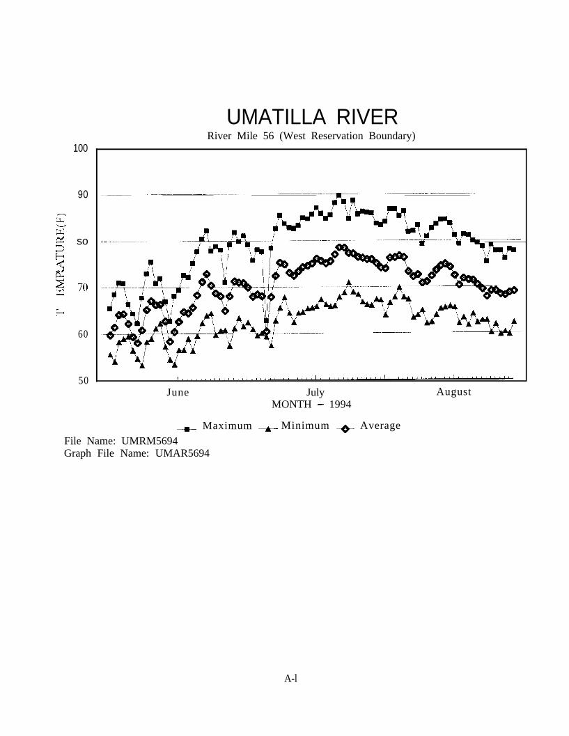
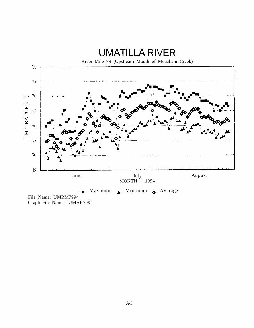
Stream temperatures at RM 56 Umatilla River exceeded 80 F, 47 out of 60 days betweenJune 21, 1994 and August 19, 1994. Temperatures at this location exceeded 68 F for 18to 21 hours per day during this time period and reached a maximum summertemperature of 89.8 F on July 21, 1994. Stream temperatures at RM 78.5 Umatilla River,RM 79 Umatilla River and RM 81.7 Umatilla River frequently exceeded 70 F from mid Junethrough mid August 1994 for two to six hour periods. During these warm months,temperatures in these stream reaches often exceeded 65 F for 12 to 14 hour periods.
27
The maximum summer stream temperature at RM 26 Wildhorse Creek was 69.3 F on July9, 1994. During the summer of 1992, temperatures exceeded 80 F on 25 days betweenJune 19 and August 18 and exceeded 70 F on eight days during the summer of 1993 atthis same location. This is an anomaly because there were drought condrtrons andintermittent flows during the summer of 1994, whereas the summers of 1992 and 1993where more normal flow years. This cooling trend might be explained due to thepresence of a spring at this site. Higher, warmer instream flows might dilute the coolingefyect the spring has on this reach during normal flow years. During lower flowconditions, the spring may have more of an influence on stream temperatures obtainedat this site.
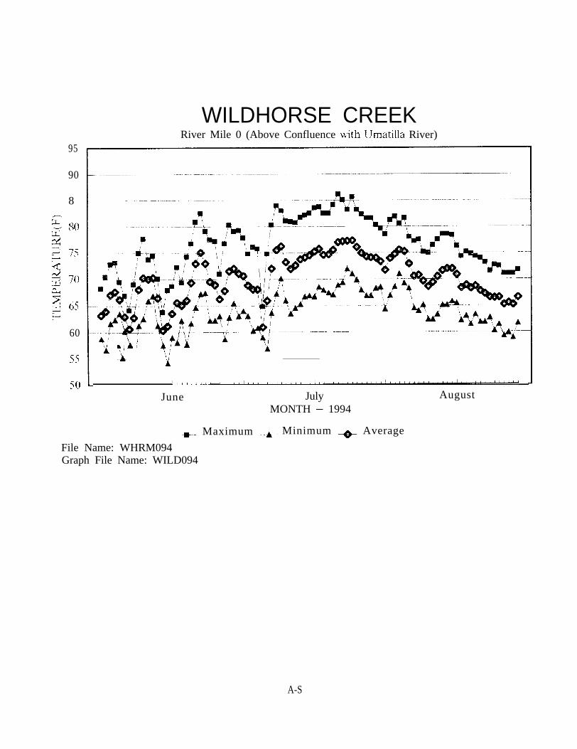
Stream temperatures obtained at RM 0 Wildhorse Creek were consistent withtemperatures recorded in previous years. Temperatures ranged between 5 and 17 Fwarmer at RM 0 Wildhorse Creek than at RM 26 Wildhorse Creek. Temperatures exceeded80 F for seven to ten hour daily intervals over a 23 consecutive day period in July 1994with a maximum summer water temperature of 86.2 F being reached on July 21, 1994.
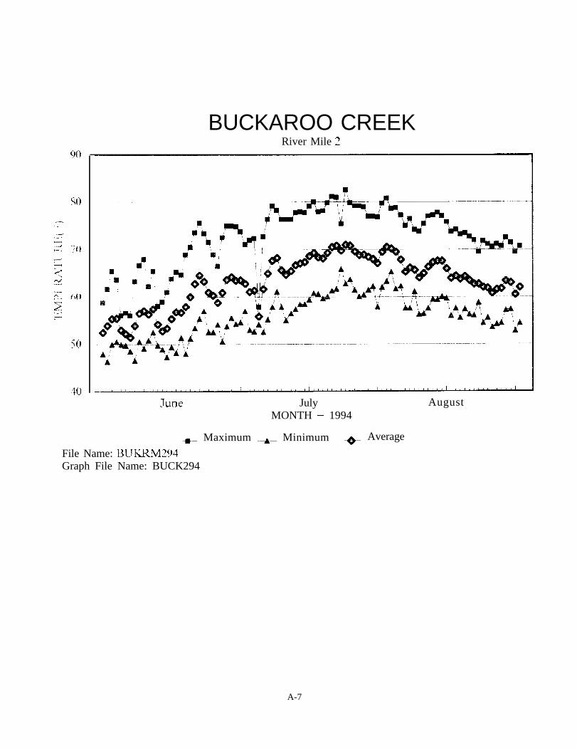
Stream temperatures at RM 2 Buckaroo Creek exceeded 80 F on five different days in lateJuly and early August. Temperatures in this stream reach frequently exceeded 70 F forfour to fourteen hour drily time intervals from mid June into early September 1994.
Stream temperatures often exceeded 70 I; fbr three to four hour intervals at RM 2 SquawCreek from early July to mtd August 1994. Wairr temperatures recorded at RM 9 SquawCreek near the confluence with Little Squaw Crrek exceeded 70 F from mid June into;-‘2 riy sqm1i her 1994 f;-;r t.i-.rre (c; icln ]ioc!r Eir‘ne per:iods.
VdXilliiiin strerlm !cmpL’ratures N-.1 r’re similiar between RM 2 Meacham Creek and RM 5.25Me&ham Creek ;vith slightly less of a drurna! flux at RM 2 Mea&am Creek. ThisA,K -.,:,,,c;enc-e ;Gil:.'4 i?c illi i-e:,!& i)f ::q(~(,j~j~~l~~ : ;;,;!rI;-:JJ r~overy and reduced solar input:$J![];in tt\CL ah.TJbl[tii c;~L]l,ir.cx:!I;e~ii prc~~~ct ;u’;!r\ :)i !. II ___ !,,.;‘I 1 -~rww R”4 2 and RM 4.25 Meacham Creek.StlCAKi t.empcratures ai both RM 2 and RM 5.25 often exceeded 75 F from mid JunethrnLlgh inid AUgLlSt.
In genera!, strp;:rn ip~npe_l~-;itups were 2 to 5 F wiriner in the summer of 1994 thanduring previous years Y&II the exception of RM 26 Wildhorse Creek. This increase canbe attributed to drought condltlons and associated low stream flows. All stream reachesmonitored, periodically exceeded the state water quality standard, 68 F, for streamtemperature.
7. Suspended Sediment Monitoring:
Siltation, a leading cause of non-purnt source poilutlon, 1s especially harmful to fish andaquatrc ecosystems. Sedlmrnts harm frs!l by reducing dissolved oxygen levels and bysmothering eggs and newly hatched fry. Sediment deposits also can eliminate aquatic
28
plants that provide cover for fish and the invertebrates they consume (Trout Unlimited,1994).
CTUIR Habitat Enhancement Project Personnel collected daily suspended sediment datafrom three ISCO Model 2700 Wastewater Samplers. Data obtained was averaged andcombined with gage station stream flow data to arrive at daily estimates of totalsediment yield at RM 2 Meacham Creek, RM 56 Umatilla River and RM 81.7 Umatilla Riverfor the 1994 annual year. This information is presented in graphical form in Appendix B.Tabular daily sediment yield data is maintained at the CTUIR Habitat EnhancementProject Office.
Stream flows during 1994 ranged from a peak of 1,650 cfs on March 4, 1994 to aminimum of 9.5 cfs in late August, September and early October 1994 at RM 2 MeachamCreek, a peak of 3,810 cfs on March 4, 1994 to a minimum of 31 cfs on August 15, 1994at RM 56 Umatilla River, and a peak of 1,400 cfs on March 2, 1994 to a minimum of 38cfs in late August and early September 1994 at RM 81.7 Umatilla River. The peaks insediment yield correspond closely to high flow events in winter and early spring.Maximum recorded 1994 daily sediment yields of 1,168 tons per day at RM 2 MeachamCreek on March 6, 1994, 977 tons per day at RM 56 Umatilla River on December 18, 1994and 184 tons per day at RM 81.7 Umatilla River on December 1, 1994 occurred duringmajor high flow events. Sediment yields were much lower during the 1994 annual thanin previous years, This can be attributed to less precipitation and resultant lower streamflows.
Data could not be compiled for spring 1995 of the project period because flow data wasnot yet available for this time period from the U.S. Geological Survey (USGS) and theOregon Water Resource Department (OWRD). Spring 1995 sediment yield data will beincluded in the 1995 Umatilla River Basin Anadromous Fish Habitat Enhancement AnnualReport.
Periodic malfunctioning of the sediment samplers resulted in incomplete data. Whenpossible, unavailable daily sediment yields were obtained by averaging sediment dataobtained prior to and following the period of malfunction. These daily sediment yieldswere incorporated into corrected monthly sediment load calculations.
Some discrepancy exists in sediment yield data obtained at RM 56 Umatilla River becausethe sediment sampling station located at RM 56 is upstream from the Wildhorse Creekconfluence, and flow data was obtained from OWRD Gage Station No. 14021000 at RM53.5 Umatilla River downstream from the mouth of Wildhorse Creek. The CIUIR WaterResources Department plans to install a gage station at RM 56 in the near future. Thisshould help to overcome this problem.
A Hach 2100P portable turbidimeter was purchased to monitor turbidity levels in theWildhorse Creek Project Area. Turbidity levels will begin to be monitored during the 1995- 96 project period.
29
Objective III. Continue Watershed Planning/Scopinp;/Education Process by Identifiinn Problemsand Developing. Creative Solutions to Land Use Problems Impacting FisheriesL__-Habitat in the [Jmatilla river Basin:__-.-_~-
1. Community Outreach Effort:
CTUIR Habitat Enhancement Project Personnel participated in the following outreachefforts during the project period:
Provided educational instruction and distributed literature regarding watershedhealth and fisheries habitat issues to Pendleton School District sixth gradeelementary students at the 1994 Outdoor School.
Coordmated with resource agencies and Union Pacific Railroad (UPRR) to developa mitigation plan for habitat degradation caused f-rem UPRR’s Blue MountainsProject double track expansion activities and to develop a cumulative impactassessment to mitlgdte for past dclLrimer~tal iiPRR railroad building andmaintenance activities in the Meacham Creek Canyon.
Met with the Oregon Waier Trust to discuss lio!ei;tial sites in the [Umatilla RiverWaLershed where inst ream rvatt,‘r rig]iL> x:o~~!:l be leased.
Attended a meeting m Helix, Oregon to Ld;scuss local land owner concernsregarding floodin,u of upper Greasewood ~‘rt:~k (SV~ldhorse Creek tributary). TheCXIR Habitat Enhmccment Bi::iog:sL :ind i,)i?FVj. D;;trict Biologis!, Tim Baileyencouraged landowners to diddress pcor crupl”ind prac:iccs in ihe .dpperwatershed. Improvements suggested included instaliation ofgrass waterways andfilter strips and construcLion vr~f‘itlrrac;~~ tc rl,>* r<‘at;c the rate of rapid water runofdnd loss of top soils.
Coordinated with UPRR Personnel regarding the removal of abandoned bridgeabutments between RM 2 and RM 12 Wildhorse Creek.
Altended Oregon Concrete and AggregaLL 1+s qissociat ien iancheon and presentation.
Coordinated with Grassland West Seed Company Sales Consultant, Jim Loiland, inidentification of native grasses to be remtroduced at the Wildhorse Creek ProjectSite.
Coordinated with the Oregon Department of Transportation (ODOT) to discusspotential restoration of a small wetland area in the Greasewood Creek Drainage.
30
Attended Umatilla River Basin Watershed Council meetings to assist withwatershed health planning and to secure their endorsement of proposed CTUIRHabitat Enhancement Projects,
Provided tours of BPA funded habitat enhancement areas on Meacham Creek,Wildhorse Creek and in other impacted Umatilla Basin Subwatersheds to: 1) theOregon Water Trust, 2) Adopt-A-Stream Foundation, 3) Anne Beier, Umatilla BasinWatershed Council Coordinator and 4) Jeff Spencer, Umatilla Basin IrrigationDistricts Environmental Advisor to demonstrate program successes and/or possiblyobtain potential cost share funding for future Umatilla River Watershedrestoration efforts.
Coordinated with NRCS Personnel regarding a watershed restoration project onMission Creek to address upland impacts in the Mission Creek Watershed. CTUIRwould address riparian impacts with separate funding.
Provided a tour of the Wildhorse Creek Project Area to the Blue Mountain Chapterof Trout Unlimited to encourage their participation with enhancement efforts.
Provided a display and literature at the Umatilla Basin Ecosystem Forum.
Coordinated with Ed Calame, Umatilla National Forest Hydrological Technician,regarding sediment retention structure design and placement for the proposed1995 Greasewood Creek Project.
Participated in Umatilla River Basin Regulatory Work Group Meetings with ODSL,COE, other commenting agencies and the public. The focus of this group is toprovide technical assistance to landowners before submitting permit applications,provide a more streamlined permit review process for land owners and to addressinstream activities on a reach by reach basis to discourage unnecessarydetrimental instream practices. CIUIR participated not only because of our roleas a commenting agency, but also to address detrimental instream practicesimpacting watershed health.
Provided a presentation of detrimental land use practices impacting fisherieshabitat in the Umatilla River Watershed and CTUIR habitat enhancements to : 1)the Homestead Youth Lodge, 2) Adopt-a-Stream Foundation Workshop, 3) UmatillaBasin Watershed Council, 4) Pendleton High School Agricultural Students, 5) CTUIRSalmon Corps participants, 6) Native Plant Society and 7) Blue Mountain Chapterof Trout Unlimited.
Provided interviews and tours of BPA funded habitat enhancement areas onMeacham Creek, Wildhorse Creek and/or other impacted Umatilla BasinSubwatersheds to Lewis and Clark Law School, Walla Walla Union Bulletin and the
31
East Oregonian to promote watershed restoration efforts in the Umatilla RiverBasin and to encourage land owner participation in CIUIR’s Habitat EnhancementProjects (see news articles in Appendix C).
2. Scoping Groups:
Initial scoping meetings were conducted during the 1993 - 94 work period toidentify landowners, sportsman clubs, special interest groups and resourceagencies to assist in identification of problems areas in major subwatersheds andin development of long term innovative methods of improving detrimental landuse practices impacting fisheries habitat. Additional scoping meetings wereconducted during the 1994 - 95 project period to receive input from landownersregarding specific subbasins in which to focus implementation efforts and toappraise participants of ongoing CIUIR Habitat Enhancement Project efforts.
A scoping meeting was conducted on the evening of June 15, 1994 at Weston-PAcEwen High School in Athena, Oregon to discuss potential project areas in theWildhorse Creek Watershed and to receive any additional input from scopinggroup participants. Scoping group participants indicated that tributaries flowinginto Wildhorse Creek from the northwest, Gerking Creek, Sand Hollow Creek andtireclst~wood Creek, app eared to be having 11~<A most mlpact on the system. It wascollectively suggested that CTUIR focus their efforts on headwater areas in thesesystems and attempt to improve land use practices and restore water quality.Scc':,iq ,group par? icipant s also indicated ekat land owners wanted scientificevidt?nce of pour wdt~rslird c.onditinns, I? ~~~1s suggested that data collectionstations should be established in the Y,?ldhnrse Creek Subbasin to monitorsediment !oads. Ten people attended the scoping meeting.
A scrzpnlg met-~.>,:,~‘irlcr :.vas ccndiicted on the evening of July 6, 1994 at YellowhawkClinic on the Reservation to discuss potential project areas in the upper UmatillaRiver Watershed (the mainstem Umatilla River and tributaries upstream ofXlission, Oregon) and to receive any additional input from scoping groupi>&icipants. S,:oping group participants indicated that CTIJIR should focusimmediate restoration efforts on Mea&am Creek, Buckaroo Creek and MissionCreek. It was suggested that ho!istic approaches, addressing all detrimental landuse practices, needed to be implemented in these subbasins. Scoping groupparticipants further indicated that tributaries exhibiting the most potential ofsustaining high numbers of sa!monids, should be priority restoration areas. Twopeople attended the scoping meeting.
Future scoping meetings to obtain additional public input and to update thepublic regarding proposed CKJIR habitat enhancements will be held in the future.
32
3. Wildhorse Creek Demonstration Project:
A habitat enhancement project was implemented between RM 9.5 and RM 10.5 WildhorseCreek to recover the riparian corridor, demonstrate the benefits of naturally functioningflood plain and wetland functions and to promote landowner participation. The projectsite is located downstream of Adams, Oregon in a highly visible area between OregonState Highway 11 and Umatilla County Road 425. Response from this project has beenvery favorable. Ten additional landowners in the Wildhorse Creek Watershed haveindicated that they wish to participate in a habitat enhancement project with CTUIR.Collectively, these landowners own over 20 river miles of stream corridor throughout thewatershed.
4. Public Education Opportunities:
The CTUIR Habitat Enhancement Project provided a variety of educational opportunitiesto the public during the project period. CTUIR cooperatively sponsored a bioengineeringworkshop with ODFW on February 23, 1995. The Streambank Stabilization Workshop -Bioengineering Techniques featured 12 guest speakers and attracted a combined total ofover 270 participants at day and evening sessions. Nurseries, grass seed companies,geotextile vendors and consulting firms provided displays for the workshop.
The purpose of this workshop was to provide information to land owners to utilizeappropriate resources for planning, designing and implementing bioengineering projects.A free reference notebook was given to each participant. Numerous resource agencypersonnel also attended the workshop.
Riparian habitat improvement training was provided to the CIUIR Salmon Corps Programand to Blue Mountain Chapter of Trout Unlimited volunteers. These individuals weretrained to assist CTUIR Habitat Enhancement Project Personnel in planting native treesand shrubs in riparian corridor areas, maintaining high tensile fence lines, installing crosssection fences and maintaining instream structures.
Additional public education opportunities provided during the 1994 - 95 project periodare listed on page under Objective III., 1. Community Outreach Effort.
5. Public Monitoring Programs:
High school students, tribal youth, scoping group participants and others wereencouraged to develop long term community stream monitoring programs (such as theEPA Region 10 Streamwalk Program). These efforts were directed at promotion of citizeninvolvement, ownership and commitment to watershed health.
33
6. Educational Brochure:
Development of a brochure to highlight successful CTUIR riparian enhancements in theUmatilla River was started during the project period. Pre-project and recovery photoshave been developed (see photos in Appendix D), a design and layout prepared and costestmates obtained. The brochures will be produced during the 1995 - 96 project periodfor dispersal to the public at educational functions to promote watershed and habitatrestoration efforts.
7. Watershed Library:
Seven educational videos were purchased by or donated to the CTUIR HabitatEnhancement Project during the project period. Miscellaneous literature and brochuresh,tve been donated to the project. These m~~tcri;;ls <ITC’ loaned or given to the public topromote land owner education on habitat enhancement needs and methodologies.
0bjt:ctive IV. Pursue -Alternative Management Mw~~h~~~~-J~_!-!‘!&&@? Impacts from Past andQF@ng Land Managefienl Activities:
1. Acquisition Land/Management Rights:
No properties containing significant anadromous salmonid habitat or managementrights were purchased during the project period. CTVIR Habitat EnhancementProject Personnel coordinated with CI’UIR Wildlife Program Personnel inidentification of potential management right (water, timber and/or grazing)acquisitions.
34
LITERATURE CITED
Bauer, S.B. and T.A. Burton. 1993. Monitoring Protocols to Evaluate Water Quality Effects ofGrazing Management on Western Rangeland Streams. EPA 910/R-93-017. EPA, Region 10,Seattle, WA. 179 p.
Bell, M.C. 1984. Fisheries Handbook of Engineering Requirements and Biological Criteria. FishPassage Development and Evaluation Program, U.S. Army Corps of Engineers, NorthPacific Division. Portland, Oregon.
Campbell, I.C., RR. James and R.T. Edwards. Farming and Streams - Impact, Research andManagement. Proc. of the Conference, The State of Our Rivers, Australia Natural History,September 1989 (as cited by Gordon, N.D., T.A. McMahon and B.L. Finlayson, 1993).
Confederated Tribes of the Umatilla Indian Reservation. 1983. Land Development Code, LandUse Map of the Umatilla Indian Reservation Land Development Code. Pendleton, Oregon.186 p.
Confederated Tribes of the Umatilla Indian Reservation. 1994. Non-point Sources of WaterPollution Assessment and Management Plan. Pendleton, Oregon. 63 p.
Elmore, W. and R.L. Beschta. 1987. Riparian Areas: Perceptions in Management. Rangelands9(6) 260 - 265 (as cited by Bauer, S.B. and T.A. Burton).
Gonthier, J.B. and D.D. Harris. 1977. Water Resources of the Umatilla Indian Reservation,Oregon. USGS Water Resources Investigations 77-3. U.S. Geological Survey, Portland,Oregon. 112 p.
Gordon, N.D., T.A. Mcmahon and B.L. Finlayson. 1993. Stream Hydrology - An Introductionfor Ecologists. John Wiley & Sons Ltd., New York, New York. 526 p.
Lambert, S.M., A. Sassman and J. Rouse. 1995. Washington and Oregon Conservation Grasses,Wildflowers, Legumes, Trees, and Shrubs. Natural Resource Conservation Service. Spokane,Washington. 67 p.
Meyers, L.H. 1987. Montana BLM Riparian Inventory and Monitoring, Riparian TechnicalBulletin No. l., BLM-MT-PT-88-001-4410, Billings, MT (as cited by Bauer, S.B. and T.A.Burton).
Platts, W.S. 1991. Livestock Grazing. “In”, Influences of Forest and Rangeland Managementon Salmonid Fishes and Their Habitat, edited by W.R. Meehan, pp 389-423. SpecialPublication 19. American Fisheries Society. Bethesda, Maryland (as cited by Bauer, S.B. andT.A. Burton).
35
Trout Unlimited. 1994. The Invisible Menace - Agricultural Polluted Run-off in our Nation’sStreams. 12 p.
U.S. Army Corps of Engineers, Walla Walla District. 1975. Flood Plain Information, UmatillaRiver Cayuse - Gibbon, Oregon. 22 p.
1J.S. Environmental Protection Agency, Region 10. Per personal communication with MichaelPurser, CIUIR Forest Hydrologist, on June 16, 1994.
I.?SDA, Forest Service - Intermountain Region Wildlife Management. 1985. Aquatic EcosystemInventory - Macroinvertebratc Analysis, Chapter 5 Aquatic Macroinvertebrate Surveys“from” Fisheries, Habitat Surveys Handbook. R-4 FSH 2609.23. Provo, Utah. 38 p.
USD4, Soil Conservation Service. 1988. Soil Survey of Umntilla County Area, Oregon. U.S.Gov. Printing Office 1988 0 - 183-557. 388 p.
Ii&r L~rc~lltll,~r; jhursda;, N o v e m b e r 10. 1991 Page 3.4- - - - - - - - - - . - . - _ _ _ _ _---..-
EAST O R E G O N I A N-. ____ -.
Landowner, triPartnership
oin forces to i provemay spur othersto join campaignBy JILL SANDEEAGof the East Orqonian
ATHENA - in a gesture Ofne ighbor ly coope ra t i on , t heU m a t i l l a I n d i a n R e s e r v a t i o nand a p r iva t e l andowner onWildhorse Creek have formed aljyear partnership to enhancewater and habitat conditions.
T h e partnershIp 1s t h e f i r s tformed between the Confeder.ated Tribes of the Umatilla In-dian Reservation and a land-owner who lives off the reservation, said Todd Shaw, fish habitat biologist with the TribalFisheries Program.
T h e p a r t n e r s h i p w i t h B u dS c h m i d t g a l l o f S o u t h S&MFarming Company is a demon-stration project, Shaw said, thathe hopes will entice more land-owners along the creek to par-ticipate when they see progressbeing made. Already severalland owners on the creek haveinquired how thev too can be-come involved wcth the tribes,he said.
C a l l e d t h e U m a t i l l a EiaslnAnadromous Fisheries ElabitatImprovement Project , the en-deavo r a ims t o improve t hewa te r t ab l e i n Schmid tga l l ’ spasture while eventually im-proving conditions for salmonr u n s t o t h e U m a t i l l a R i v e r ,where the creek empties, Shawsaid. However, i t also is ex-pected to improve upland areas,taking on a holistic approach,Shaw said.
Schmidtgall, who has ownedthe land for 15 years, said hehas watched the creek erodeand lose much of its vegetation.While he is glviy up some pas-ture lands along the creek’s cor-ridor, he is willing to cooperateto gain long-term benefits, hesaid.
“It will he very nice to see the
Fish habitat biologist Todd Shaw. backyround. looks on as crews Athena. Ninteen structures werebegin building sediment-retention structures in Wddhorse Creek near ment deposits have increased.
S’“” PC’0 by ,121 Km-
built in October and already sedi.
results,” he said.T h e p r o j e c t e n c o m p a s s e s
about 1G miles of Schmidtgall’sland along Wildhorse Creek.Sediment retention structureswere built in the creek in midOctober when they would leastaffect migrating fish, Shaw sardThe 18 structures will create aback water area that will allowabout 2 feet of kqadient changesupstream. The entlre effect uill
crc-ate a new channe l bo t t om.raising t h e ?!lnrmei g rade ande v e n t u a l l y t h e w a t e r t a b l e ,Shaw said. .IIore will be addedin the nest tuo years, he said.
T h e s t r u c t u r e s will a l l o wSshmldtgall to heneflt from sed~Irnent I?at from lands upstream,Shaw >;11<! \Vlth w a t e r bncklng
u p u n t b E m 5 ti (1 I m t: 11 t I .ili,!mj,rd rin the creek bank,. so:,:!tli.t! trt,+,s and grazs can b e
contmuously seeded during thenext five years, he said
About 1,500 to 2,0&l willowsand cottonwoods will be plant-ed, said Shaw, who estimatesahuut 30 to 40 percent of themwill survive. Local landownersdonated the trees from theirl ands , and t he r e se rva t i on ’ sSa lmon Corps member s willplant them
About 10 acres of land will be
burned to plant natli’e grasses,with ali seeding completed byt h e e n d o f N o v e m b e r , Shawsaid.
Fenc ing a l so w i l l be cornpleted by January, he said ThespecKI frnc1n:: Will limit hve-s tock acces s while a l lowingwildlife to pass through It un-harmed. he said.
Schmi~itg.~ll, a whtsat g:awer,admits he would not have t&en
habitat“We need to e tbeyo?d the rngerPpwadrnkfrng and
cooperatively likewe are doing inthis project.”
Todd Shaw,tribal biologist
on such a project alone.“I took the easy way out,” he
jokes. An added attraction wasthe full fundmg from the tribes,he said
Funding the project, whichwill cost up to 8O,CM, are theBonneville P o w e r Administra-tlons. Bureau of Indian Affairsand U.S. Fish and WIldlife Ser-vice
Although the land 1s not tribeal land, the reservation main.tains an Interest m It because Itonce was wlthm the reservationhounr!:irv, Shaw said 1Ie be-Ilc,:es the land was a wetlandbeaver area 100 to Ii0 years agothat ‘&a‘, saturated 1~1th water
Shn,x a d m i t s t h e I L$ mileproject will not cure all of the34rmle creek’s problems. Butthe tribes would like to main-tain an ongoing presence on thecreek, he said. They have beenworkmg to educate area grow-ers through scoping meetingsheid earlier this year.
The project ~111 be an educa-7ionnl process for area growers,who are often tmes unjustlyblamed for the high erosion,Schmidtgall said.
“I thmk the farmer IS doingmore now than they ever have,”he said
“It’s nrit ail the landowners.It’s really highly erodable solI,”Shaw said. “We need to get be-yond the finger pomting andwork cooperatively like we aredoing !n this project.”0
Cornferederated Tribes 1
S U M M A R Y : T h e ConfedcrareTrjbes of the il’-nat,ii,~ Indl;ln Rcier-vatfor- ii sp3x~~nq 530.000 to I+store a ponion of’JC’,ldhorse CreekPasrlng “~~Liir~sli on nearby H,gh-way I I vi1!1 be ab:r to watch thecreek ct?Jnge over a period o f)TXS
By BECKY KRAMERCH ,h” “nmn-Bullet,”
ADAMS. Ore - In a few years,Todd Shw hopes a mile longstretch of R’ildhorse Creek ulll beU~lr~COglliZ~lble
R’here there arc barren bnrths.he hopes to see co!onies of cotstonwood and \\l!low trees. \Vherethere is scruff cheat grass, tallskmds of nallvc grxscs. ?\!:(I
where there is muddy v;ater. aclear-fluwing stream
Project paving way for collegeEigt!tccn menllmx of the Cul:icdcrat<rl Ttiiws of the Urnatills
The “Salmon Corps” is a division oi the AmeriCorps programinitlnted by President Ii111 Clinton last Year
Llembers of five Northirest tnbes, ages 13~2.5. \vill spend a yea:\vn:kmg on variety of rcitoration pf~oJec:.i, such as plnntlng trees,fencing npari:ln zones and conductmg sp,“~t~ing sur~egs. They\rurk for mmimum wage, and earn a $4 ~0 stipend toward co!-icge or a vocational school at the end of the ;/car.
\\‘enix Redelk. II, was among those \<i:o signed up for the pro-gram She said she likes tsorking outdoors. and wanted to earnsome niuney for coilcge “But it does get really cold,” said Weniu,as she plnnted \nllow shoots along \Vddhoi-se Creek this week.
The program kicked off last month with 72 participants fromthe Umatilla, Nez Perce. iVarm Sp;mgs, Takama. andSho:~shorle-Bnnnuck tribes
The $1 6 million Salmon Car-ps is a partnership between theII S Department of Encr@, the Columbia River Inter-Tribal FishCummisslon. the Lrrth Consewatlon Corps and the five tribes.
The Confederated Tribes of theUmatilla In- creek’s steep banks. LYithout the S&b1 F,,rming of Athena is provid-dlan Reser- roots to hold the water, the water ing the land.vntion is table has dropped 10 to 15 feet.sinking Anti the creek runs broivn with top
Bud Schmidtgall of S&h1 Farms
$30,000 into a JUllsaid he \YRS a bit wary when the
creck-tribes first approached him about
So salmon live in \Yildhorserenovation
the restoration project. He’dCreek, and just a few steelhead never :vorked with them before
project near use its lorber stretches. People and Lvasn’t sure what to expect.Adams. The sometimes wonder why the tribes Eut the more Schmidtgall heardland borders are trying to restore a stream aboul the proposal, the better heHigh\cq I I. \v!thout anadromotis fish, Shnw liked itShnw. a fish- SHAW 52idhnbi:rlt biolw
Llcmhers of the Salmon Corps
gist for the tribes, hopes passingEl:! \!‘ildhOrsc Creek is a tl;lijOr - a program that employs youth
motorists wiil takt, a keen Interesttr-ibi;tav of the Unl;,tlll,, Iiivcr, on the reservation - already haveichew the tribes have lvorked ior
in the changing landscape.planted 2,000 willow and cot-
:;ears to bolster salmon and sic& tonwo& trees along the mile ofHe Au envisions the pro,ect head runs The creek dumps some creek Sedment basins have been
serving as a shoirpiece, to let ol tlw he.lviest loads of sediment built to remove soil from the wa-other inndowmers see what can be into the Ums:ll!n River And its tcr. As soil settles out of the water,accomplished through coopera- \r,iter’ tenrper-atui‘es - Lvhich can the \ra!er level in the creek slowi)tion \rith the t&es. cwxd 80 degrees - aiso affect wll riz.b:
The project is part of an o\crn:l conditions for fish in the IJmntiila The tnbc.) nilI do all the workeffort to improve the health of the I<lvcr-. Sha;v said on the creek. and maintain it for 15Umati!la Basin l,$atershed. The project near Adams is the years. In return. Schmidtgall will
\‘<l;dhorse Creek ivinds through 2rs: stream restoration effort the give up some pasture land. A cor-a hen~il!: fxmed and grazed alea !: hes IIJI.C’ tacKed off oi the rcs ridor a!~::g the stream dll beof northern Umntllla County, and e;x.ntion Sh;i;v said fenced, and he has agreed to keepthe creek shous the cumulntl~;e The Bonne\illr Power Adminis- his co’.+5 oat of that area for 15eifects of years of heavy agriciil- tralion. the I!urc3u of Indian :c~ ye,rrs xliilc the vegetation growstural use hIost of the \egetat;on fdlrr and the US Fish and \Viidl;fchas been stlippcd awag from lhc Seticc is providing the money. Set v CREEK, Page 10
V Creek restoration project in Oregonbeing supported by farmers in the area
Con:,n,,cd from C;JZ;~ 9 Some of the land is alre,rdv good pasture, he said. Butother areas tl”~ up quicki! in the summer.
back But Sci;midtgall figures he’s the \o:!:;cr in the‘TIC XC:I \I a!. prc~babl~ n rrlnrstiy patch with bea-
long-term.vef-s n hundred years ago, Shaw said. As the water
“1 figured, ‘How could I go !vrong”” said Schmidt-t,lblc rises, the creek \$-~ll begin to sub-irrigate the
@I. who saw the need for the iyork hmlself, bsdt saidpasture again, he said Several other IandoRmers
he couldn’t afford to spend 530,001) on one m~!e ofalong \Ylldhorse Creek already had expressed inter-
streamest in working \vith the tr!bes on similar projects,
“This \\irill enhance the property vaiue, a::d buld upShau said. As people drive by on IIighway 11, he be-
the pasture I’m loo!Gng fonvard to it,” he said.licves the dramatic changes in creek’s appearance;cill convince others to get m:olved as \vell.
Appendix D
Riparian Recovery Project Photos
Meacham Creek downstream of the Boston Canyon Creek Confluence
Top Photo: 1988, prior to project implementation. Problems included: 1) an unstable,migrating channel, 2) a lack of natural channel sinuosity, 3) a lack of diverse riparian vegetationfrom overgrazing, resulting in unstable streambanks and inadequate shading, and 4) lowinstream flows and reduced water storage.
Bottom Photo: 1992, four years after the following improvements were implemented: 1)armoring streambanks with rock at critical erosion points, 2) placement of rock wing deflectorsto slow stream velocities, capture sediments and rebuild streambanks, 3) revegetation ofstreambanks with grasses and native riparian tree species to increase shading, stabilizestreambanks, increase water retention capabilities and improve water quality, and 4) exclusionof livestock from the stream corridor to allow vegetative recovery and provide streambankprotection.