23
UNDERSTANDING EXTREME WEATHER M MOHAPATRA INDIA METEOROLOGICAL DEPARTMENT NEW DELHI-110003 m. [email protected]
| Date post: | 11-May-2018 |
| Category: |
Documents |
| Upload: | nguyenngoc |
| View: | 214 times |
| Download: | 1 times |

UNDERSTANDING EXTREME WEATHER
M MOHAPATRA
INDIA METEOROLOGICAL DEPARTMENT
NEW DELHI-110003

Presentation layout
Introduction
Extreme Weather Monitoring and Forecasting
Present Day Status,
Gap and Way Aheads
Conclusions
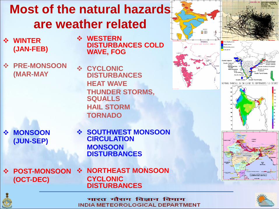
Most of the natural hazards
are weather related
WINTER
(JAN-FEB)
PRE-MONSOON
(MAR-MAY
MONSOON
(JUN-SEP)
POST-MONSOON
(OCT-DEC)
WESTERN DISTURBANCES COLD WAVE, FOG
CYCLONIC DISTURBANCES
HEAT WAVE
THUNDER STORMS, SQUALLS
HAIL STORM
TORNADO
SOUTHWEST MONSOON CIRCULATION
MONSOON DISTURBANCES
NORTHEAST MONSOON
CYCLONIC DISTURBANCES

Major Natural Disasters and risk management in India
Risk management
Hazard Analysis and statistics
Vulnerability Analysis
Preparedness and Planning
Early Warning System
Prevention and Mitigation
Early Warning Components
Obserbation, Monitoring and
analysis and Prediction
Warning generation
Warning dissemination
Public education and Outreach
Verification of warning
• India Meteorological Department : All Meteorological hazards
• Central Water Commission : Floods,
• Geological Survey of India : Landslides
• Indian National Centre for Ocean Information Services : Tsunami
Meteorological Information from IMD is used in several ways for
Disaster Risk Reduction in the region.
Hazard Monitoring, Early warning and Mitigation.
Technical support in risk assessment, preparedness & planning,
Management of natural resources from disasters (Agriculture/Water
resources, Health, Energy Resources etc)

Hazard Monitoring and Forecast Process
Action
Runs of different Models,
Consecutive runs from the same model,
Ensemble runs ("choosing the best member")
Numericalforecasts
ModelDecisionmaker
Numericalforecasts
Endforecast
Initial conditions (Observations)
ForecasterModel
Model runs
Numericalforecasts
Broad Classification of
Observations
Surface
Upper Air
Space Based
• Pilot Balloon
• RSRW
• Profiler
• Ground Based RADAR
• Aircraft
• Geoststionary Satellites
• Polar Orbiting Satellites
• AWS
• ARG
• SYNOP
• BUOYS
• AVIATION
• SHIPS
Monitoring and
Forecast Process

Nowcasting for next 3-6 hours(Venue/ location specific)
Short Range for next 72 hours (Location/District/Met Sub-division)
Medium Range for next 3-7 days(District)
Extended range for 10-15 days (Met Subdivision/State)
Long range for month/season (Homogeneous regions/country)
Public Weather Local Forecast
Tropical Cyclone Forecast & Warnings
Warnings related to all other Disaster (heavy rain/snow, thunderstorm,
squall, hailstorm, strong wind, storm surge, heat/cold wave, fog etc)
Sea State and Coastal Zone Forecasts, Fishermen warning
Forecasts to Aviation
Forecasts for Agriculture
Customized Forecasts to different Sectors- Power, Tourism, Defense,
Adventure, Road/Railway transports, Public Utility, VIP functions,
Strategic operations, Space, event based etc
IMD’s Forecast & Warning

North Region
Central Region
South Region
West Region
East Region
North East Region
Regional CentresDelhi, Kolkata, Guwahati, Nagpur, Mumbai, Chennai
Pune Centre for Research /Training and surface instrumentation
National Weather
Forecasting Centre
at New Delhi

Meteorological Centres1. Srinagar
2. Chandigarh
3. Shimla
4. Dehra Dun
5. Lucknow
6. Patna
7. Itanagar
8. Jaipur
9. Ranchi
10. Agartatala
11. Ahmedabad
12. Bhopal
13. Raipur
14. Bhuvaneshwar
15. Hyderabad
16. Bangalore
17. Thiruvananthapuram
18. Panjim
19. Gangtok

Cyclone Warning Four stage cyclone warning
(Pre-cyclone watch, cyclone
alert, cyclone warning, post-
landfall outlook )
Sea area bulletin
Coastal weather bulletin
Bulletins for Indian navy
Fisheries warnings
Port warnings
Aviation warning
Bulletins for departmental
exchanges
Bulletins for AIR/
Doordarshan/ press
DTH bulletins
Warnings for registered
users.

Cyclone warning system
Example of graphical presentation of cyclone warning

Thunderstorm:
• Moderate Thunderstorm
Loud peals of thunder with frequent
lightning flashes, moderate to heavy
rains and maximum wind speed 29 to 74
kmph
• Severe Thunderstorm :
Continuous thunder and lightning,
heavy rains and maximum wind speed ≥
75 kmph

Hailstorm and Squall
Frequency of Hailstorms in
100 years period • Slight Hailstorm :
Sparse, usually small size and
often mixed with rain
• Moderate Hailstorm :
Fall abundant enough to
whiten ground
• Heavy Hailstorm :
Includes at least a proportion
of large stones
SQUALL:
A sudden increase of
wind speed by at least 29
kmph(16 kts), the speed rising
to 40 kmph (22 kts) or more
and lasting for at least one
minute
Moderate : Surface wind
speed ( in gusts) upto 80 kmph
Severe : Surface wind
speed ( in gusts) > 80 kmph

Nowcasting of thunderstorms
Nowcasting.
Location specific forecast for severe
weather for planning of aviation
activities, sport events and high risk
operations.

15
Heat wave & Thundersquall warning (25 May, 2015)
Heat wave (5.0 to
6.00C above
normal)
Thunder
squall at
isolated
places
>22
kts
Severe heat
wave
( 7.00 C above
Normal or
station reported
45.00 C or more)
Thunder
squall at
a few
places
>22
kts
and
abo
ve
Severe heat
wave
( 7.00 C above
Normal or
station reported
45.00 C or more)
at wide area
Severe
Thunder
squall at
many
places
>22
kts
and
abo
ve
No warning No
warning
Nil

16
Cold wave/ visibility & ground frost warning,
(11 January, 2015)
Cold wave
(5.0 to 6.00C
below
normal)
Ground
frost at one
or two
places
Visibility
at one or
two places
< 500 M
Severe cold
wave ( 70 C
below
normal)
Ground
frost at a
few places
Visibility
at a
few/many
places
<200 M
Cold day
( day temp.
<150C) or
severe cold
wave
Ground
frost at
many
places
Visibility
at most
places
<50 M
No warning No warning No warning

17
Fog/visibility warning (17 January, 2015)
Visibility at
one or two
places
<500M
Visibility at a
few/many
places
<200 M
Visibility at
most places
<200 M
or less
than <50
M
No Warning Nil

18
Heavy snow & hail storm warning
(12 January, 2015)
Very heavy
snow at
one or two
to many
places
>65
cm
Ths + hail+Squall
Heavy
snow at a
few places
>35
cm
Ths+hail+ squall
Heavy
snow at
one or two
places
>35
cm
Ths+ squall
No
warning
Nil

Flood Warning: Basic Structure
.
Streamflow Forecasts
Hydrological ModelHydrological
Observations
Meteorological
Observations
Weather Forecasts
Weather Forecast Models
IMD
CWC
Flood
Warnings

FLOOD WARNING• Real time Hydro-meteorological observations
• Real-time communication and modeling.
• Decision support system for issuing quantitative
precipitation forecast (QPF) and heavy rainfall
warning in place
• Heavy rainfall forecast is still a challenge
Heavy rain at
isolated places
>6.5 cm
or more
Heavy to very
heavy at
isolated/ few
places
>12.5
cm or
more
Heavy to very
heavy at a few
places or
isolated
extreme heavy
>12.5
cm or
more
No warning Nil

• Onset, spread, intensification and
cessation of drought (near real-time
basis) on a daily, weekly, monthly and
seasonal time scale over the country
(RF departures, Aridity Anomaly Index,
SPI).
• Weekly Drought Outlook, based on this
index, which indicates the impending
drought scenario in the country in the
subsequent week.
Drought Monitoring and Forecasting
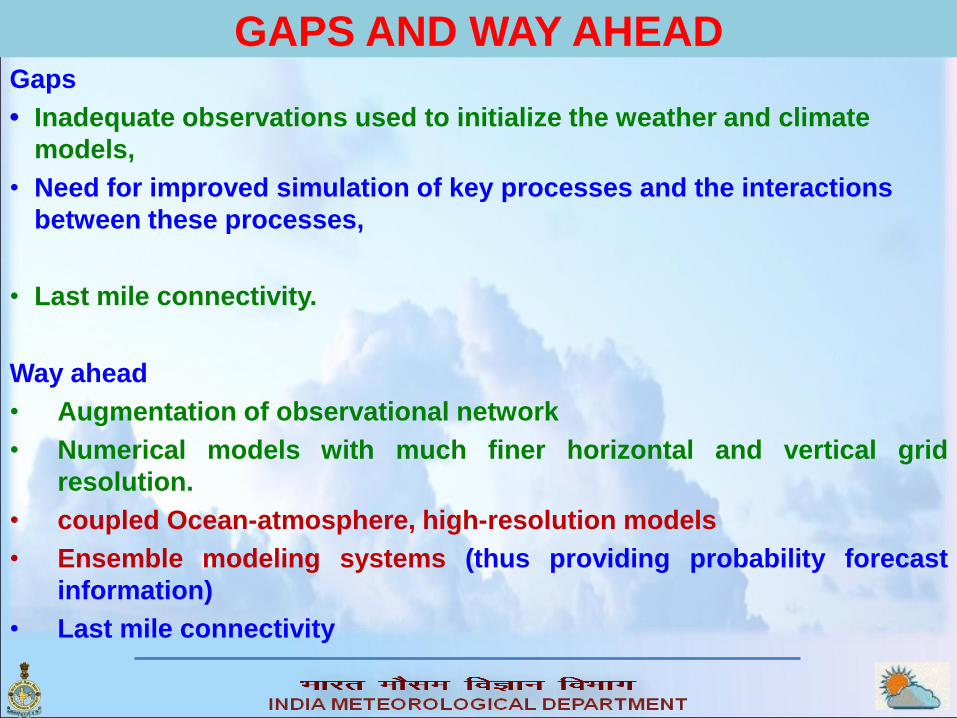
GAPS AND WAY AHEADGaps
• Inadequate observations used to initialize the weather and climate
models,
• Need for improved simulation of key processes and the interactions
between these processes,
• Last mile connectivity.
Way ahead
• Augmentation of observational network
• Numerical models with much finer horizontal and vertical grid
resolution.
• coupled Ocean-atmosphere, high-resolution models
• Ensemble modeling systems (thus providing probability forecast
information)
• Last mile connectivity

Thank you


