unforeSeeable Earthquakes in Switzerland An Exhibition That Makes Earthquakes Visible on the Occasion of the 100 th Anniversary of the Swiss Seismological Service. Please, don’t take me home
Transcript
unforeSeeableEarthquakes in Switzerland
An Exhibition That Makes Earthquakes Visible on the Occasion of the 100th Anniversary of the Swiss Seismological Service.
Please,
don’t take m
e
home
Contents
Part 1: Circling the RotundaPart 2: Triangular TowersPart 3: Maps (inside the rotunda)Part 4: Animations (inside the rotunda)
Circling the Rotunda
Part 1:
Earthquake Country
Is There a Tradition of Earthquakes in Switzerland?Seismic activity in Switzerland and the formation of the Alps are closely linked and can be attributed to the same underground processes. Because these movements have been hap-pening for millions of years, there is a very long-standing tradition of earthquakes in Switzerland.
What Do We Know about Earthquakes in Switzerland Long Before Our Generation?Thanks to historical sources, we can trace the history of earthquakes in Switzerland back to the 11th century. In late antiquity and the early Middle Ages, the written culture was not so strong as it is today, so there are only a few references and brief descriptions that refer to earthquakes. “Natural archives” provide valuable information for these periods and those even further back in history. Examples for such natural archives are lake-bed sediments that document soil slippage as a result of earthquakes, broken stalactites and stalagmites in caves, and archaeological fi ndings. However, these paleo-seismological methods are not entirely reliable.
What Happens during an Earthquake?
The earth’s crust consists of several large and a number of smaller lithospheric plates. These plates can converge, diverge, or grind past each other.
Earthquakes are caused by a sudden release of stress along faults in the crust. Due to continuous motion of tec-
tonic plates, stress builds in the rock on both sides of a fault. When the stress exceeds the strength of the rock, it is released in a sudden, jerky movement. The seismic energy released propagates as waves through the earth and along its surface, and these waves cause the shak-ing that we feel.
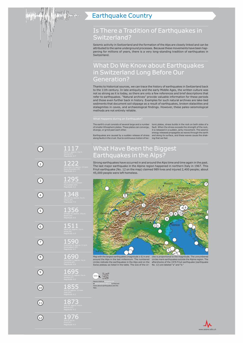
What Have Been the Biggest Earthquakes in the Alps?Strong earthquakes have occurred in and around the Alps time and time again in the past. The last major earthquake in the Alpine region happened in northern Italy in 1967. This Friuli earthquake (No. 12 on the map) claimed 989 lives and injured 2,400 people; about 45,000 people were left homeless.
1117 March 1, approx. 4 p.m.Verona (IT)Magnitude: 6.7
Have a look at Snapshot 05 at www.seismo.ethz.ch to fi nd out more about earthquakes and the Alps.
1
2
3
4
5
6
7
8
9
10
11
12
12
34
5
6
7
8
9
10 11 AB
12
3˚E
3˚E
4˚E
4˚E
5˚E
5˚E
6˚E
6˚E
7˚E
7˚E
8˚E
8˚E
9˚E
9˚E
10˚E
10˚E
11˚E
11˚E
12˚E
12˚E
13˚E
13˚E
14˚E
14˚E
15˚E
15˚E
16˚E
16˚E
17˚E
17˚E
18˚E
18˚E
43˚N 43˚N
44˚N 44˚N
45˚N 45˚N
46˚N 46˚N
47˚N 47˚N
48˚N 48˚N
49˚N 49˚N
Bern
Basel
Vienna
Trento
Innsbruck
Munich Linz
Zurich
Lausanne
Geneva
Trieste
Salzburg
Graz
Ljubljana
Brescia
Venice
Nice
Genova
Florence
Milano
TorinoGrenoble
Map with the largest earthquakes (magnitude ≥ 6) in and around the Alps in the last millennium. The numbered circles indicate the earthquakes in the Alps and on the Swiss plateau as listed in the table. The size of the cir-
cles is proportional to the magnitude. The unnumbered circles mark earthquakes outside the Alpine region. The aftershocks of the 1976 Friuli earthquake (earthquake No. 12) are labeled “a” and “b.”
www.
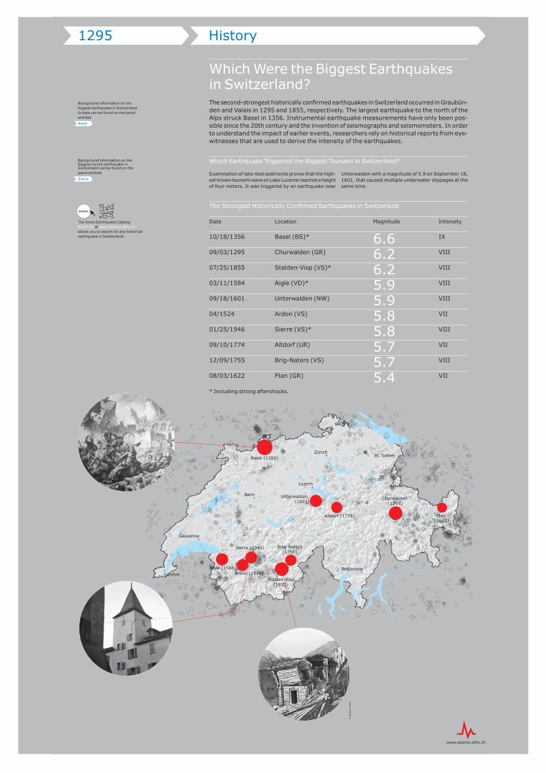
Which Were the Biggest Earthquakes in Switzerland?The second-strongest historically confi rmed earthquakes in Switzerland occurred in Graubün-den and Valais in 1295 and 1855, respectively. The largest earthquake to the north of the Alps struck Basel in 1356. Instrumental earthquake measurements have only been pos-sible since the 20th century and the invention of seismographs and seismometers. In order to understand the impact of earlier events, researchers rely on historical reports from eye-witnesses that are used to derive the intensity of the earthquakes.
Which Earthquake Triggered the Biggest Tsunami in Switzerland?
Examination of lake-bed sediments proves that the high-est known tsunami wave on Lake Lucerne reached a height of four meters. It was triggered by an earthquake near
Unterwalden with a magnitude of 5.9 on September 18, 1601, that caused multiple underwater slippages at the same time.
The Strongest Historically Confi rmed Earthquakes in Switzerland
Date Location Magnitude Intensity
10/18/1356 Basel (BS)* 6.6 IX
09/03/1295 Churwalden (GR) 6.2 VIII
07/25/1855 Stalden-Visp (VS)* 6.2 VIII
03/11/1584 Aigle (VD)* 5.9 VIII
09/18/1601 Unterwalden (NW) 5.9 VIII
04/1524 Ardon (VS) 5.8 VII 01/25/1946 Sierre (VS)* 5.8 VIII
09/10/1774 Altdorf (UR) 5.7 VII
12/09/1755 Brig-Naters (VS) 5.7 VIII
08/03/1622 Ftan (GR) 5.4 VII
* Including strong aftershocks.
1295 History
The Swiss Earthquake Catalog ECOS-09 at www.seismo.ethz.ch allows you to search for any historical earthquake in Switzerland.
•
!
•
•
•
•
•
•
!
Bern
Luzern
Genève
Zürich
Lausanne
Bellinzona
St. GallenBasel (1356)
Unterwalden (1601)
Altdorf (1774)
Churwalden (1295)
Ftan (1622)
Aigle (1584)Ardon (1524)
Stalden-Visp(1855)
Sierre (1946) Brig-Naters(1755)
www.
Background information on the biggest earthquake in Switzerland to date can be found on the panel entitled
Basel
Background information on the biggest recent earthquake in Switzerland can be found on the panel entitled
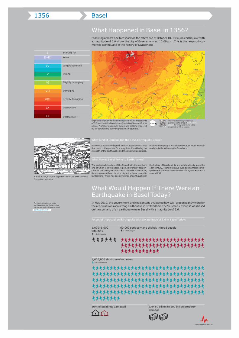
Expected ShakeMap if an earthquake with a magnitude of 6.6 was to strike Basel today (based on Seismo 12 sce-nario). A ShakeMap depicts the ground shaking triggered by an earthquake at every point in Switzerland.
What Kind of Damage Did the 1356 Earthquake Cause?
Numerous houses collapsed, which caused several fi res that could not be put out for a long time. Considering the strength of the earthquake and the destruction caused,
relatively few people were killed because most were al-ready outside following the foreshock.
What Makes Basel Prone to Earthquakes?
The geological structure of the Rhine Plain, the southern end of which is in the Basel region, is primarily respon-sible for the strong earthquakes in the area. After Valais, the area around Basel has the highest seismic hazard in Switzerland. There has been evidence of earthquakes in
the history of Basel and its immediate vicinity since the 14th century. There may have even been a major earth-quake near the Roman settlement of Augusta Raurica in around 250.
What Would Happen If There Were an Earthquake in Basel Today?In May 2012, the government and the cantons evaluated how well prepared they were for the repercussions of a strong earthquake in Switzerland. The Seismo 12 exercise was based on the scenario of an earthquake near Basel with a magnitude of 6.6.
Potential Impact of an Earthquake with a Magnitude of 6.6 in Basel Today:
CHF 50 billion to 100 billion property damage
1,000–6,000 fatalities@ = 1,000 people
@@@@@@
1,600,000 short-term homeless@ = 10,000 people
@@@@@@@@@@@@@@@@@@@@@@@@@@@@@@@@
@@@@@@@@@@@@@@@@@@@@@@@@@@@@@@@@
@@@@@@@@@@@@@@@@@@@@@@@@@@@@@@@@
@@@@@@@@@@@@@@@@@@@@@@@@@@@@@@@@
@@@@@@@@@@@@@@@@@@@@@@@@@@@@@@@@
@@@@@@@@
50% of buildings damaged
60,000 seriously and slightly injured people@ = 1,000 people
@@@@@@@@@@@@@@@@@@@@@@@@
@@@@@@@@@@@@@@@@@@@@@@@@
@@@@@@@@@@@
What Happened in Basel in 1356?Following at least one foreshock on the afternoon of October 18, 1356, an earthquake with a magnitude of 6.6 shook the city of Basel at around 10.00 p.m. This is the largest docu-mented earthquake in the history of Switzerland.
1356 Basel
The Swiss Seismological Service publishes a ShakeMap at www.seismo.ethz.ch for every earthquake with a magnitude of 2.5 or greater.
I
II–III
IV
V
VI
VII
VIII
IX
X+
Scarcely felt
Weak
Largely observed
Strong
Slightly damaging
Damaging
Heavily damaging
Destructive
Destructive ++
www.
Further information on major earthquakes in the Alpine region can be found on the panel entitled
Earthquake Country
Basel, 1356, fi ctional depiction from the 16th century, Sebastian Münster
When Was the Swiss Seismological Service Set Up?With the anchoring of earthquake monitoring in a federal act in 1914, the Swiss Seismo-logical Service became the offi cial federal agency for earthquake monitoring. The govern-ment thus transformed what had been a voluntary activity performed by the Swiss Earth-quake Commission since 1878 into an institution that is attached to ETH Zurich today. Since its establishment 100 years ago, the Swiss Seismological Service has recorded around 13,100 local earthquakes.
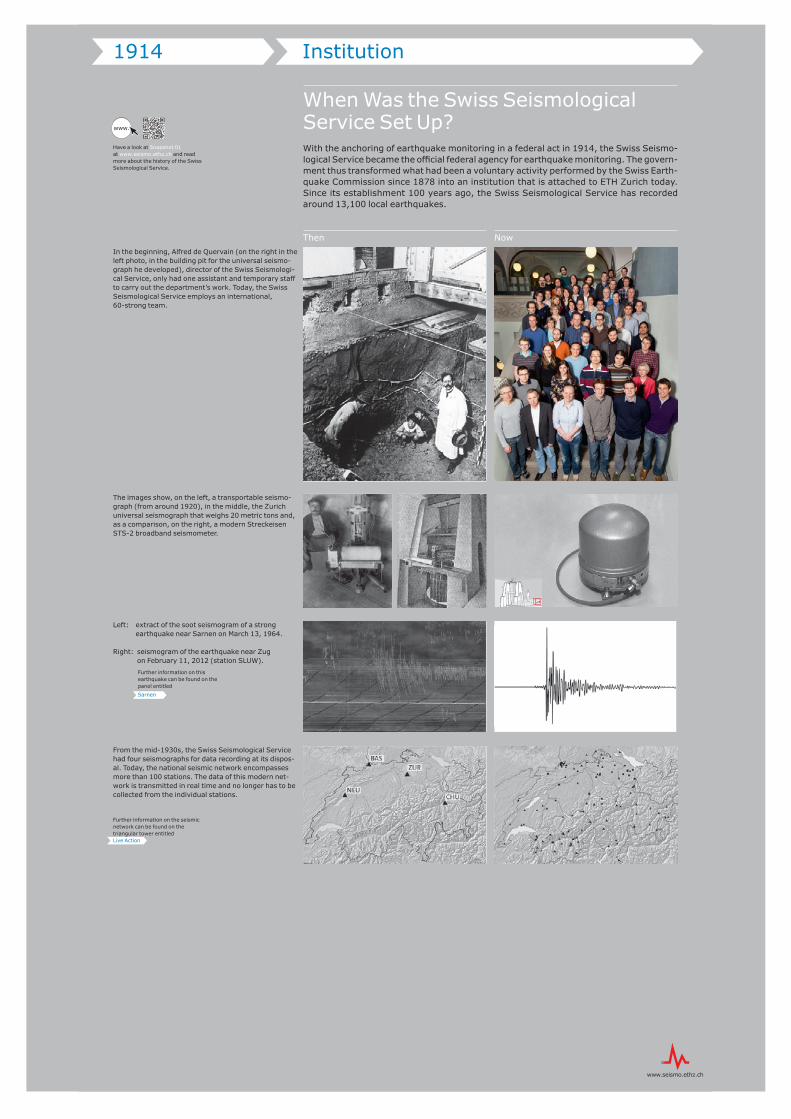
In the beginning, Alfred de Quervain (on the right in the left photo, in the building pit for the universal seismo-graph he developed), director of the Swiss Seismologi-cal Service, only had one assistant and temporary staff to carry out the department’s work. Today, the Swiss Seismological Service employs an international, 60-strong team.
The images show, on the left, a transportable seismo-graph (from around 1920), in the middle, the Zurich universal seismograph that weighs 20 metric tons and, as a comparison, on the right, a modern Streckeisen STS-2 broadband seismometer.
Left: extract of the soot seismogram of a strong earthquake near Sarnen on March 13, 1964.
Right: seismogram of the earthquake near Zugon February 11, 2012 (station SLUW).
From the mid-1930s, the Swiss Seismological Service had four seismographs for data recording at its dispos-al. Today, the national seismic network encompasses more than 100 stations. The data of this modern net-work is transmitted in real time and no longer has to be collected from the individual stations.
1914 Institution
Have a look at Snapshot 01 at www.seismo.ethz.ch and read more about the history of the Swiss Seismological Service.
Then Now
www.
Further information on this earthquake can be found on the panel entitled
Sarnen
Further information on the seismic network can be found on the triangular tower entitledLive Action
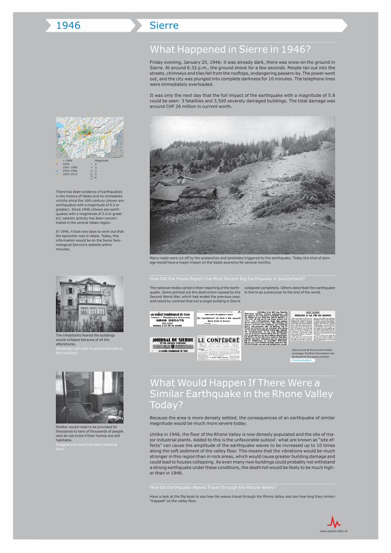
What Happened in Sierre in 1946?Friday evening, January 25, 1946: it was already dark, there was snow on the ground in Sierre. At around 6.32 p.m., the ground shook for a few seconds. People ran out into the streets, chimneys and tiles fell from the rooftops, endangering passers-by. The power went out, and the city was plunged into complete darkness for 10 minutes. The telephone lines were immediately overloaded.
It was only the next day that the full impact of the earthquake with a magnitude of 5.8 could be seen: 3 fatalities and 3,500 severely damaged buildings. The total damage was around CHF 26 million in current worth.
How Did the Media Report the Most Recent Big Earthquake in Switzerland?
The national media varied in their reporting of the earth-quake. Some pointed out the destruction caused by the Second World War, which had ended the previous year, and noted by contrast that not a single building in Sierre
collapsed completely. Others described the earthquake in Sierre as a precursor to the end of the world.
What Would Happen If There Were a Similar Earthquake in the Rhone Valley Today?Because the area is more densely settled, the consequences of an earthquake of similar magnitude would be much more severe today.
Unlike in 1946, the floor of the Rhone Valley is now densely populated and the site of ma-jor industrial plants. Added to this is the unfavorable subsoil: what are known as “site ef-fects” can cause the amplitude of the earthquake waves to be increased up to 10 times along the soft sediment of the valley floor. This means that the vibrations would be much stronger in this region than in rock areas, which would cause greater building damage and could lead to houses collapsing. As even many new buildings could probably not withstand a strong earthquake under these conditions, the death toll would be likely to be much high-er than in 1946.
How Do Earthquake Waves Travel through the Rhone Valley?
Have a look at the flip book to see how the waves travel through the Rhone Valley and see how long they remain “trapped” on the valley floor.
!(
!(!(
!(
!(
!(
!(
!(
Sion
VispBrigAigle
Sierre
Montey
Zermatt
Martigny
Leukerbad
0 10 20 km5
Magnitude23456
< 194619461947–19691970–19921993–2014
Many roads were cut off by the avalanches and landslides triggered by the earthquake. Today this kind of dam-age would have a major impact on the Valais economy for several months.
1946 Sierre
The inhabitants feared the buildings would collapse because of all the aftershocks. Would you still want to spend the night in this building?
Shelter would need to be provided for thousands to tens of thousands of people who do not know if their homes are still habitable. Imagine your aunt had been sleeping here.
There has been evidence of earthquakes in the history of Valais and its immediate vicinity since the 16th century (shown are earthquakes with a magnitude of 5.5 or greater). Since 1946 (shown are earth-quakes with a magnitude of 2.0 or great-er), seismic activity has been concen-trated in the central Valais region.
In 1946, it took two days to work out that the epicenter was in Valais. Today, this information would be on the Swiss Seis-mological Service’s website within minutes.
Have a look at the current media coverage. Further information can be found on the panel entitled Communication
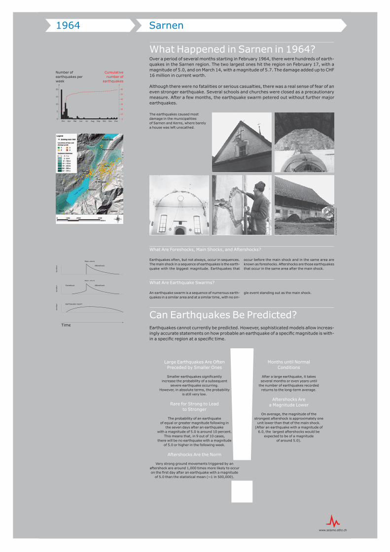
What Happened in Sarnen in 1964?Over a period of several months starting in February 1964, there were hundreds of earth-quakes in the Sarnen region. The two largest ones hit the region on February 17, with a magnitude of 5.0, and on March 14, with a magnitude of 5.7. The damage added up to CHF 16 million in current worth.
Although there were no fatalities or serious casualties, there was a real sense of fear of an even stronger earthquake. Several schools and churches were closed as a precautionary measure. After a few months, the earthquake swarm petered out without further major earthquakes.
What Are Foreshocks, Main Shocks, and Aftershocks?
Earthquakes often, but not always, occur in sequences. The main shock in a sequence of earthquakes is the earth-quake with the biggest magnitude. Earthquakes that
occur before the main shock and in the same area are known as foreshocks. Aftershocks are those earthquakes that occur in the same area after the main shock.
What Are Earthquake Swarms?
An earthquake swarm is a sequence of numerous earth-quakes in a similar area and at a similar time, with no sin-
gle event standing out as the main shock.
Can Earthquakes Be Predicted?Earthquakes cannot currently be predicted. However, sophisticated models allow increas-ingly accurate statements on how probable an earthquake of a specifi c magnitude is with-in a specifi c region at a specifi c time.
The earthquakes caused most damage in the municipalities of Sarnen and Kerns, where barely a house was left unscathed.
Large Earthquakes Are Often Preceded by Smaller Ones
Smaller earthquakes signifi cantly increase the probability of a subsequent
severe earthquake occurring. However, in absolute terms, the probability
is still very low.
Rare for Strong to Lead to Stronger
The probability of an earthquake of equal or greater magnitude following in
the seven days after an earthquake with a magnitude of 5.0 is around 10 percent.
This means that, in 9 out of 10 cases, there will be no earthquake with a magnitude
of 5.0 or higher in the following week.
Aftershocks Are the Norm
Very strong ground movements triggered by an aftershock are around 1,000 times more likely to occur on the fi rst day after an earthquake with a magnitude
of 5.0 than the statistical mean (~1 in 500,000).
Months until Normal Conditions
After a large earthquake, it takes several months or even years until
the number of earthquakes recorded returns to the long-term average.
Aftershocks Are a Magnitude Lower
On average, the magnitude of the strongest aftershock is approximately one
unit lower than that of the main shock. (After an earthquake with a magnitude of
6.0, the largest aftershocks would be expected to be of a magnitude
of around 5.0).
What Does Seismic Hazard Mean?The seismic hazard specifies the probability that a specific ground acceleration will occur at a specific place within a specific period.
How Is Seismic Hazard Determined?
To estimate the seismic hazard, seismologists use region-al information about earthquake history, tectonics, and geology. They also evaluate historical damage reports and develop models of wave propagation. The produc-
tion and regular review of seismic hazard reports for Swit-zerland is one of the core tasks of the Swiss Seismolog-ical Service.
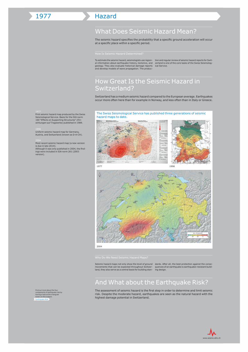
How Great Is the Seismic Hazard in Switzerland?Switzerland has a medium seismic hazard compared to the European average. Earthquakes occur more often here than for example in Norway, and less often than in Italy or Greece.
Why Do We Need Seismic Hazard Maps?
Seismic hazard maps not only show the level of ground movements that can be expected throughout Switzer-land, they also serve as a central basis for building stan-
dards. After all, the best protection against the conse-quences of an earthquake is earthquake-resistant build-ing design.
And What about the Earthquake Risk?The assessment of seismic hazard is the first step in order to determine and limit seismic risk. Despite the moderate hazard, earthquakes are seen as the natural hazard with the highest damage potential in Switzerland.
1977 Hazard
1977First seismic hazard map produced by the Swiss Seismological Service. Basis for the SIA norm 160 “Effects on Supporting Structures” (Ein-wirkungen auf Tragwerke) published in 1989.
1998Uniform seismic hazard map for Germany, Austria, and Switzerland (known as D-A-CH).
2004Most recent seismic hazard map (a new version is due in late 2014). Although it was only published in 2004, the find-ings were included in SIA norm 261 (2003 version).
Find out more about the four components of earthquake risk by having a look at the triangular tower on this subject.
Earthquake Risk
The Swiss Seismological Service has published three generations of seismic hazard maps to date.
1977 1998
2004
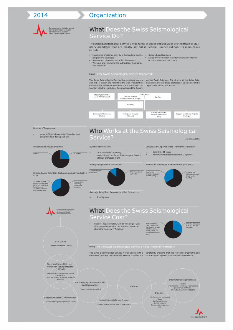
2014 Organization
What Does the Swiss Seismological Service Do?The Swiss Seismological Service’s wide range of duties and activities are the result of stat-utory mandates that are mostly set out in Federal Council rulings. Its main tasks include:
How Is the Swiss Seismological Service Organized?
The Swiss Seismological Service is a nondepartmental unit of ETH Zurich and reports to the Vice President for Research and Economic Relations. It works in close con-junction with the Institute of Geophysics and the Depart-
ment of Earth Sciences. The director of the Swiss Seis-mological Service is also a professor of seismology at the Department of Earth Sciences.
Who Are the Swiss Seismological Service’s Most Important Partners?
The Swiss Seismological Service works closely with a number of partners. As a scientific service provider, it is
constantly ensuring that the relevant agreements and contracts are in place to secure its independence.
Who Works at the Swiss Seismological Service? (As at March 2014)
• Budget: approximately CHF 10 million per year (fluctuates between ± 1 to 2 million based on changing third-party funding)
What Does the Swiss Seismological Service Cost?
• Monitoring of seismic activity in Switzerland and its neighboring countries
• Assessment of seismic hazard in Switzerland• Warning and informing the authorities, the public,
and the media
• Research and teaching• Swiss involvement in the international monitoring
of the nuclear test ban treaty
87% short-term contracts
13% permanent employees
Number of Employees
• Around 60 employees distributed across roughly 50 full-time positions
Proportion of Men and Women
Distribution of Scientific, Technical, and Administrative Staff
Number of Professors
• 1 full professor (Wiemer) as director of the Swiss Seismological Service
• 1 titular professor (Fäh)
Average Employment Conditions
Average Length of Employment for Scientists
• 3 to 5 years
Longest-Serving Employees (Permanent Positions)
• Scientist: 31 years• Administrative/technical staff: 12 years
Number of Employees Financed through Projects
Approx. 40 financed through third-party funding
ETH fixed funding: CHF 3.3 million per year
¼ women¾ men
²⁄³ scientists (including 10 doctoral students)
�⁄³ technical and administrative staff (of which ²⁄³ IT and technical and �⁄³ administrative and managerial)
Approx. 20 financed through fixed funding
Approximately CHF 7 million in third-party funding (ETH research loans, SNSF, EU, industrial projects, etc.)
ETH Zurich
– Department of Earth Sciences
Swiss Federal Office of Energy
– Swiss Federal Nuclear Safety Inspectorate
Cantons
Federal Office for Civil Protection
– National Emergency Operations Centre
Industry
– (Re-)insurance companies– Nagra
– Geothermal energy– Nuclear industry
– Construction engineers– SIA
Swiss Agency for Development and Cooperation
– Swiss Humanitarian Aid Unit
International organizations
– CTBTO– International seismology organizations
(ISC, FDSN, ORFEUS)– Global Earthquake Model (GEM)
Steering Committee Inter-vention in Natural Hazards
(LAINAT)
– Federal Office for the Environment– MeteoSwiss
– WSL Institute for Snow and Avalanche Research
Earthquake Monitoring (Clinton)
Steering Committee Lead: VPFW Siegwart
Earthquake Analysis (Wiemer)
Teaching
DirectorateDirector: Wiemer
Deputy Director: HaslingerExeCom
Earthquake Hazard and Risk Assessment
(Fäh)
Support and Special Projects (Haslinger)
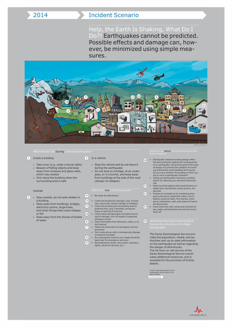
Help, the Earth Is Shaking, What Do I Do?! Earthquakes cannot be predicted. Possible effects and damage can, how-ever, be minimized using simple mea-sures.
What Should I Do During a Strong Earthquake?
Inside a building
• Take cover (e.g. under a sturdy table)• Beware of falling objects and keep
away from windows and glass walls, which may shatter
• Only leave the building when the surrounding area is safe
Outside
• Stay outside, do not seek shelter in a building
• Keep away from buildings, bridges, electricity pylons, large trees, and other things that could collapse or fall
• Keep away from the shores of bodies of water
In a vehicle
• Stop the vehicle and do not leave it during the earthquake
• Do not stop on a bridge, at an under-pass, or in a tunnel, and keep away from buildings at the side of the road (danger of collapse)
What Do I Do After a Strong Earthquake?
• Be ready for aftershocks
• Check the building for damage, and, if neces-sary, leave with caution (danger of collapse)
• Check the building and surrounding area for potential fires, and, if possible, extinguish these or alert the fire service
• Check water and gas pipes and electrical wir-ing for damage; turn off supply if suspected damage is found
• Seek information from television, radio, or on the Internet
• Follow the instructions of emergency service personnel
• Only make phone calls in emergencies (danger of network overload)
• No unnecessary travel by car (roads should be kept clear for emergency services)
• Be prepared for power cuts (trains, elevators, lights, electronic devices, etc.)
What Can I Do Before a Strong Earthquake to Be Better Prepared?
• Earthquake-resistant building design offers the best protection against the consequences of an earthquake; the primary goal of this type of design is to prevent the collapse of a build-ing and thereby avoid fatalities and injuries
Do you know whether the building in which you live or work is earthquake resistant?
• Taking out earthquake insurance is another option for reducing your personal (financial) risk
• Make sure that objects that could fall down or topple over, and thereby cause injuries, are secured
• Prepare an emergency kit containing emer-gency provisions (especially water), torch, battery-powered radio, first-aid box, emer-gency medication, cash, and copies of import-ant documents
• Know where the main valves and switches for gas, water, and electricity are and how to turn them off
What Does the Swiss Seismological Service Do in the Event of a Major Earthquake?
The Swiss Seismological Service pro-vides the population, media, and au-thorities with up-to-date information on the earthquake as well as regarding the danger of aftershocks. The 24-hour on-call service of the Swiss Seismological Service coordi-nates additional measures, and is available for the provision of further details.
2014 Incident Scenario
10
12
13
14
15
1
2
3
4
11
14
5
6
7
8
9
Further information about current earthquakes can be found on the panel entitled
Communication
1
3
2
4
5 6
7
8
91011
12
13
14
15
Illustration: Marion Deichmann
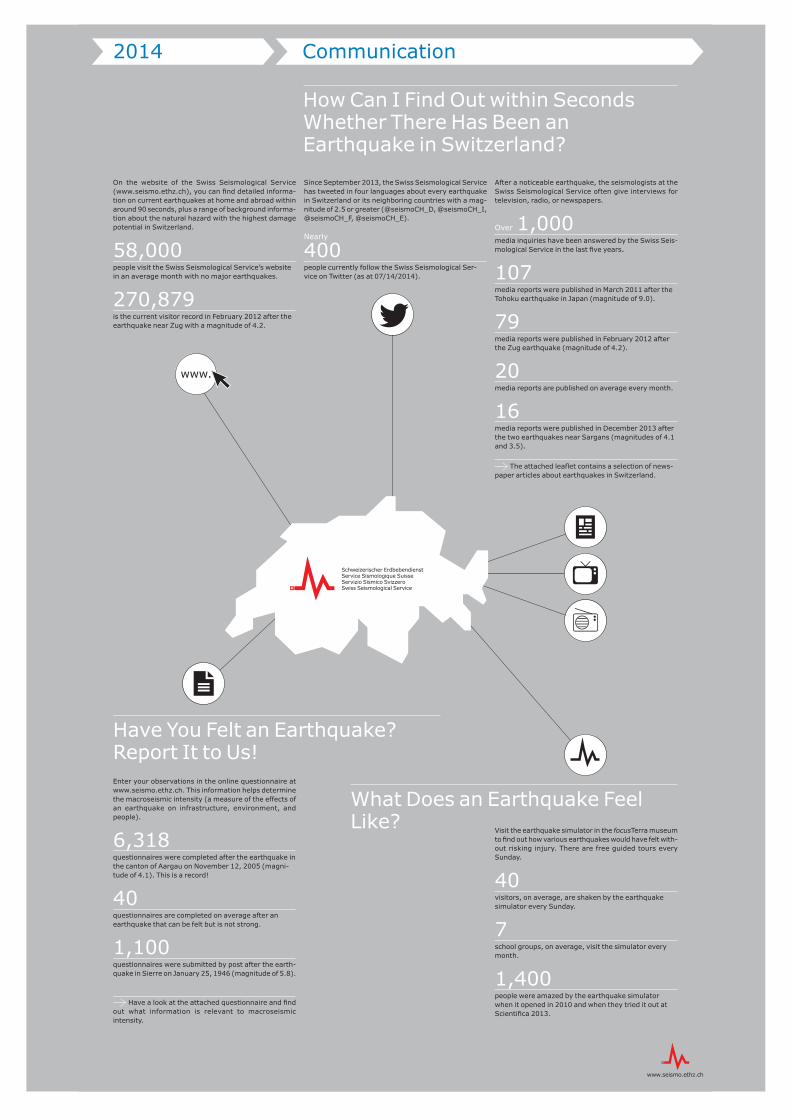
Enter your observations in the online questionnaire at www.seismo.ethz.ch. This information helps determine the macroseismic intensity (a measure of the effects of an earthquake on infrastructure, environment, and people).
6,318questionnaires were completed after the earthquake in the canton of Aargau on November 12, 2005 (magni-tude of 4.1). This is a record!
40 questionnaires are completed on average after an earthquake that can be felt but is not strong.
1,100 questionnaires were submitted by post after the earth-quake in Sierre on January 25, 1946 (magnitude of 5.8).
Have a look at the attached questionnaire and find out what information is relevant to macroseismic intensity.
Visit the earthquake simulator in the focusTerra museum to find out how various earthquakes would have felt with-out risking injury. There are free guided tours every Sunday.
40 visitors, on average, are shaken by the earthquake simulator every Sunday.
7 school groups, on average, visit the simulator every month.
1,400 people were amazed by the earthquake simulator when it opened in 2010 and when they tried it out at Scientifica 2013.
2014 Communication
How Can I Find Out within Seconds Whether There Has Been an Earthquake in Switzerland?
Have You Felt an Earthquake? Report It to Us!
What Does an Earthquake Feel Like?
On the website of the Swiss Seismological Service (www.seismo.ethz.ch), you can find detailed informa-tion on current earthquakes at home and abroad within around 90 seconds, plus a range of background informa-tion about the natural hazard with the highest damage potential in Switzerland.
58,000 people visit the Swiss Seismological Service’s website in an average month with no major earthquakes.
270,879 is the current visitor record in February 2012 after the earthquake near Zug with a magnitude of 4.2.
Since September 2013, the Swiss Seismological Service has tweeted in four languages about every earthquake in Switzerland or its neighboring countries with a mag-nitude of 2.5 or greater (@seismoCH_D, @seismoCH_I, @seismoCH_F, @seismoCH_E).
Nearly 400 people currently follow the Swiss Seismological Ser-vice on Twitter (as at 07/14/2014).
After a noticeable earthquake, the seismologists at the Swiss Seismological Service often give interviews for television, radio, or newspapers.
Over 1,000 media inquiries have been answered by the Swiss Seis-mological Service in the last five years.
107 media reports were published in March 2011 after the Tohoku earthquake in Japan (magnitude of 9.0).
79 media reports were published in February 2012 after the Zug earthquake (magnitude of 4.2).
20 media reports are published on average every month.
16 media reports were published in December 2013 after the two earthquakes near Sargans (magnitudes of 4.1 and 3.5).
The attached leaflet contains a selection of news-paper articles about earthquakes in Switzerland.
100
Illustration: Marion Deichmann
www.
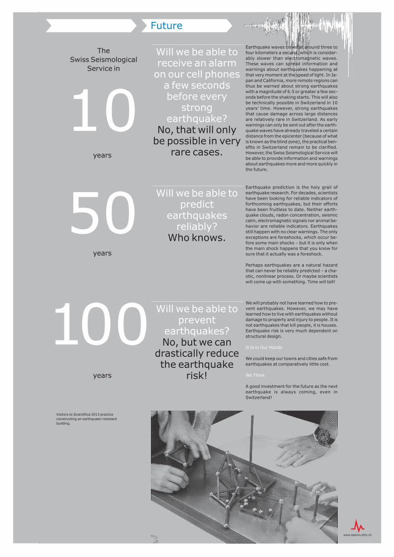
Future
Will we be able to receive an alarm on our cell phones
a few seconds before every
strong earthquake?
No, that will only be possible in very
rare cases.
Will we be able to predict
earthquakes reliably?
Who knows.
Will we be able to prevent
earthquakes? No, but we can
drastically reduce the earthquake
risk!
The Swiss Seismological
Service in
years
years
years
10
50
100Visitors to Scientifica 2013 practice constructing an earthquake-resistant building.
Earthquake waves travel at around three to four kilometers a second, which is consider-ably slower than electromagnetic waves. These waves can spread information and warnings about earthquakes happening at that very moment at the speed of light. In Ja-pan and California, more remote regions can thus be warned about strong earthquakes with a magnitude of 6.5 or greater a few sec-onds before the shaking starts. This will also be technically possible in Switzerland in 10 years’ time. However, strong earthquakes that cause damage across large distances are relatively rare in Switzerland. As early warnings can only be sent out after the earth-quake waves have already traveled a certain distance from the epicenter (because of what is known as the blind zone), the practical ben-efits in Switzerland remain to be clarified. However, the Swiss Seismological Service will be able to provide information and warnings about earthquakes more and more quickly in the future.
Earthquake prediction is the holy grail of earthquake research. For decades, scientists have been looking for reliable indicators of forthcoming earthquakes, but their efforts have been fruitless to date. Neither earth-quake clouds, radon concentration, seismic calm, electromagnetic signals nor animal be-havior are reliable indicators. Earthquakes still happen with no clear warnings. The only exceptions are foreshocks, which occur be-fore some main shocks – but it is only when the main shock happens that you know for sure that it actually was a foreshock.
Perhaps earthquakes are a natural hazard that can never be reliably predicted – a cha-otic, nonlinear process. Or maybe scientists will come up with something. Time will tell!
We will probably not have learned how to pre-vent earthquakes. However, we may have learned how to live with earthquakes without damage to property and injury to people. It is not earthquakes that kill people, it is houses. Earthquake risk is very much dependent on structural design.
It Is in Our Hands
We could keep our towns and cities safe from earthquakes at comparatively little cost.
We Think
A good investment for the future as the next earthquake is always coming, even in Switzerland!
Triangular Towers
Part 2:
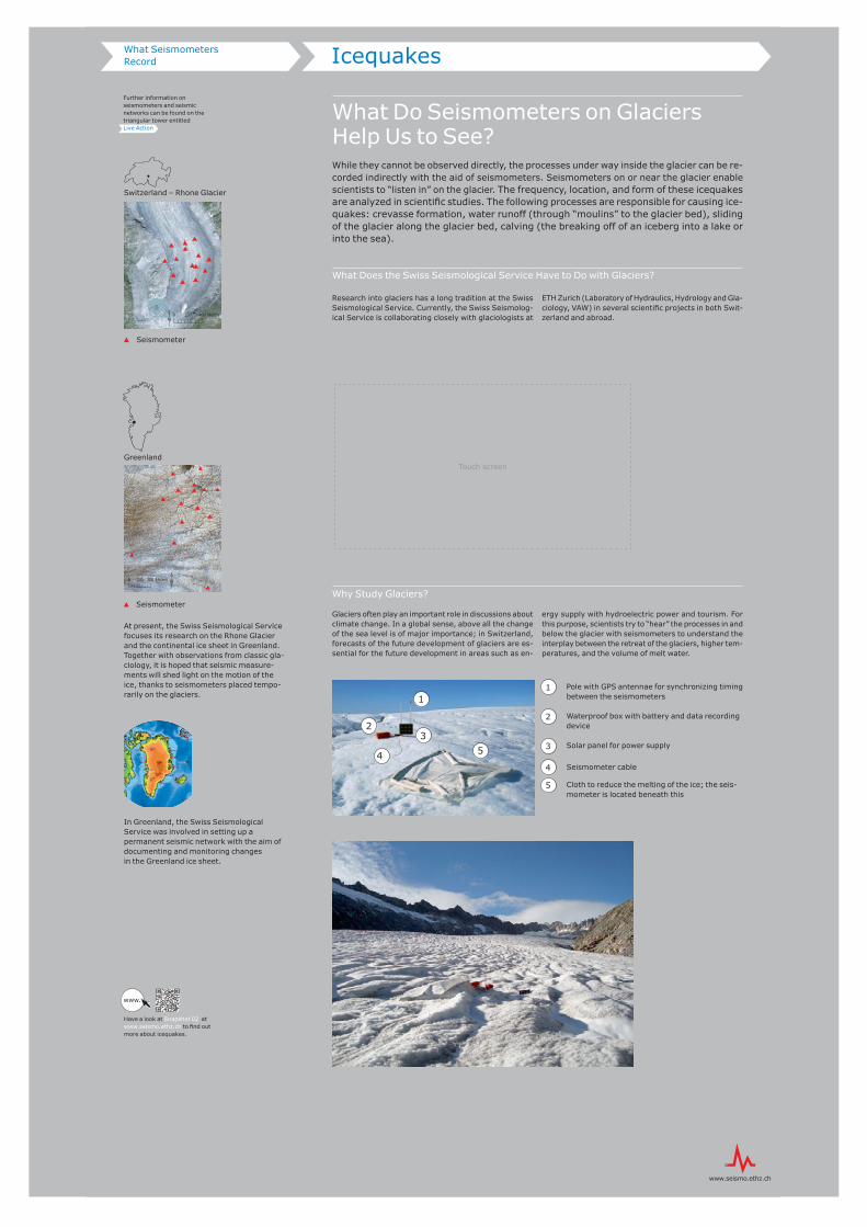
What Do Seismometers on Glaciers Help Us to See?While they cannot be observed directly, the processes under way inside the glacier can be re-corded indirectly with the aid of seismometers. Seismometers on or near the glacier enable scientists to “listen in” on the glacier. The frequency, location, and form of these icequakes are analyzed in scientific studies. The following processes are responsible for causing ice-quakes: crevasse formation, water runoff (through “moulins” to the glacier bed), sliding of the glacier along the glacier bed, calving (the breaking off of an iceberg into a lake or into the sea).
What Does the Swiss Seismological Service Have to Do with Glaciers?
Research into glaciers has a long tradition at the Swiss Seismological Service. Currently, the Swiss Seismolog-ical Service is collaborating closely with glaciologists at
ETH Zurich (Laboratory of Hydraulics, Hydrology and Gla-ciology, VAW) in several scientific projects in both Swit-zerland and abroad.
Why Study Glaciers?
Glaciers often play an important role in discussions about climate change. In a global sense, above all the change of the sea level is of major importance; in Switzerland, forecasts of the future development of glaciers are es-sential for the future development in areas such as en-
ergy supply with hydroelectric power and tourism. For this purpose, scientists try to “hear” the processes in and below the glacier with seismometers to understand the interplay between the retreat of the glaciers, higher tem-peratures, and the volume of melt water.
Switzerland – Rhone Glacier
Seismometer
Greenland
Seismometer station
Seismometer
At present, the Swiss Seismological Service focuses its research on the Rhone Glacier and the continental ice sheet in Greenland. Together with observations from classic gla-ciology, it is hoped that seismic measure-ments will shed light on the motion of the ice, thanks to seismometers placed tempo-rarily on the glaciers.
In Greenland, the Swiss Seismological Service was involved in setting up a permanent seismic network with the aim of documenting and monitoring changes in the Greenland ice sheet.
0 150 300 Meters
0 200 400 Meters
1
23
4 5
1 Pole with GPS antennae for synchronizing timing between the seismometers
2 Waterproof box with battery and data recording device
3 Solar panel for power supply
4 Seismometer cable
5 Cloth to reduce the melting of the ice; the seis-mometer is located beneath this
Icequakes What Seismometers Record
Have a look at Snapshot 02 at www.seismo.ethz.ch to find out more about icequakes.
Further information on seismometers and seismic networks can be found on the triangular tower entitled Live Action
www.
Touch screen
What Are Man-Made Earthquakes?The subsoil is in constant motion, which is why minor and major earthquakes shake the earth every day. However, not all of these vibrations are of natural origin – some are triggered by human activity. In such cases, science speaks of “induced earthquakes” or “induced seismicity.”
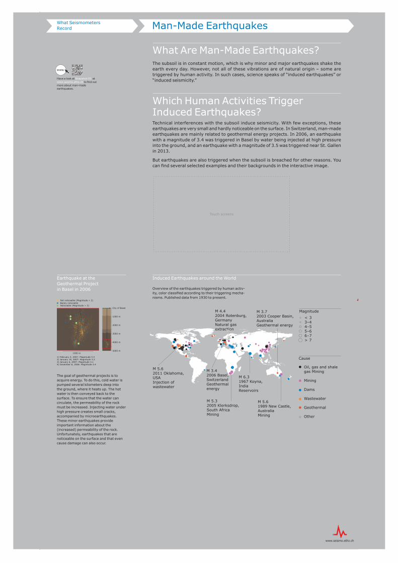
Which Human Activities Trigger Induced Earthquakes?Technical interferences with the subsoil induce seismicity. With few exceptions, these earthquakes are very small and hardly noticeable on the surface. In Switzerland, man-made earthquakes are mainly related to geothermal energy projects. In 2006, an earthquake with a magnitude of 3.4 was triggered in Basel by water being injected at high pressure into the ground, and an earthquake with a magnitude of 3.5 was triggered near St. Gallen in 2013.
But earthquakes are also triggered when the subsoil is breached for other reasons. You can fi nd several selected examples and their backgrounds in the interactive image.
Induced Earthquakes around the World
Overview of the earthquakes triggered by human activ-ity, color classifi ed according to their triggering mecha-nisms. Published data from 1930 to present.
< 33–44–55–66–7> 7
Magnitude
Cause
Oil, gas and shale gas Mining
Mining
Dams
Wastewater
Geothermal
Other
M 6.31967 Koyna, IndiaReservoirs
M 3.72003 Cooper Basin, Australia Geothermal energy
M 5.32005 Klerksdrop, South AfricaMining
M 3.42006 Basel, SwitzerlandGeothermal energy
M 4.42004 Rotenburg, GermanyNatural gas extraction
M 5.62011 Oklahoma, USAInjection of wastewater
M 5.61989 New Castle, AustraliaMining
2000 m
5000 m
4000 m
1000 m
City of Basel
3000 m
1000 m
Not noticeable (Magnitude < 2)Barely noticeableNoticeable (Magnitude > 3)
1) February 2, 2007: Magnitude 3.32) January 16, 2007: Magnitude 3.23) January 6, 2007: Magnitude 3.14) December 8, 2006: Magnitude 3.4
12
3
4
Man-Made EarthquakesWhat Seismometers Record
Have a look at Snapshot 03 at www.seismo.ethz.ch to fi nd out more about man-made earthquakes.
www.
Earthquake at the Geothermal Projectin Basel in 2006
The goal of geothermal projects is to acquire energy. To do this, cold water is pumped several kilometers deep into the ground, where it heats up. The hot water is then conveyed back to the surface. To ensure that the water can circulate, the permeability of the rock must be increased. Injecting water under high pressure creates small cracks, accompanied by microearthquakes. These minor earthquakes provide important information about the (increased) permeability of the rock. Unfortunately, earthquakes that are noticeable on the surface and that even cause damage can also occur.
Touch screens
Natural or Man-Made?Seismometers are highly sensitive measuring devices that record natural as well as man-made ground movements. These signals may originate in the direct surroundings or – in some cases – on the other side of the earth.
Guess whether the signals are man-made or natural and who or what triggered them.
Other SignalsWhat Seismometers Record
2000 m
5000 m
4000 m
1000 m
Stadt Basel
3000 m
1000 m
Nicht spürbar (Magnitude < 2)Kaum spürbarSpürbar (Magnitude > 3)
1) 2. Februar 2007: Magnitude 3.32) 16. Januar 2007: Magnitude 3.23) 6. Januar 2007: Magnitude 3.14) 8. Dezember 2006: Magnitude 3.4
12
3
4
Icequake: naturalAn opening crevasse on the Rhone Glacier, recorded on the glacier.
Blasting: man-madeBlasting work in a quarry in Switzerland.
Rockfall: naturalRockfall in Switzerland.
Teleseismic earthquake: naturalMarch 11, 2011, earthquake in To-hoku (Japan) with a magnitude of 9.0. The signal traveled around the world.
Sonic boom:man-madeOctober 10, 2013, sonic boom, triggered by two fi ghter jets in Switzerland.
Local earthquake:naturalFebruary 11, 2012, earthquake near Zug with a magnitude of 4.2.
Nuclear testing, DPRK:man-madeFebruary 12, 2013, underground nuclear weapons test in North Ko-rea. The signal traveled around the world.
Induced earthquake:man-madeJanuary 6, 2007, earthquake in Ba-sel with a magnitude of 3.1, caused by deep drilling for the geothermal project in Basel.
Triggering an earthquake yourself? A seismometer is installed at the bottom of the museum tower’s staircase in focusTerra, which is capable of recording even the slightest tremors.focusTerra
Real-Time DataLive Action
Was There an Earthquake?More than 100 seismic monitoring stations in the national measuring station network con-stantly monitor earthquake activity in Switzerland and its neighboring countries. They re-cord every tremor, and as soon as an earthquake is detected, the Swiss Seismological Ser-vice immediately publishes details about the location, the magnitude, and the possible effects.
Have a look at the monitors to see what seismometers are currently recording and wheth-er there has been an earthquake in the past hours. The vertical components of the five measuring stations are displayed.
Earthquake
Data recordingThe seismometers register the earthquake.
DataprocessingThe magnitude, the location, and possible effects of the earthquake are automatically determined in the data processing center.
AlarmingAs from a certain magnitude, the population, the authorities, and the on-call service are informed automatically.
Manual data analysisManual localization of the earthquake and additional calculation by a seismologist to find out more about the characteristics of the earthquake.
Real-time signals of the last five minutes transmitted by five seis-mic stations in Switzerland.
Maybe you will discover an earthquake that has just occurred in Switzerland. Earthquakes with a magnitude of 2.0 or greater are usually visi-ble to the naked eye.
Here you can see the seismic monitoring data of the last four hours in Switzerland.
The red lines automatically mark detected possible earthquakes. The signals are not processed until several stations have triggered. If the automatic data processing system detects an earthquake, it triggers a corresponding signal. Blue and green lines indicate that a seismologist has identified the earthquake manually.
The map on the right shows the earthquakes in Switzerland in the past 90 days.
Look and see where earthquakes have occurred around the world in the past 24 hours.
The highest amplitudes indicate earthquakes that have occurred somewhere in the world. The highly sensitive seismometers of the national seismic network record the tremors that these earth-quakes have caused in Switzerland.
Compared with the signals of local earthquakes on the upper mon-itors, the tremors of teleseismic earthquakes last longer and have different frequencies.
The map on the right shows all earthquakes worldwide with a mag-nitude of 5.0 or greater in the past 24 hours.
10
0Seconds
20
40
90
Monitor
Monitor
Monitor
Seismic NetworkLive Action
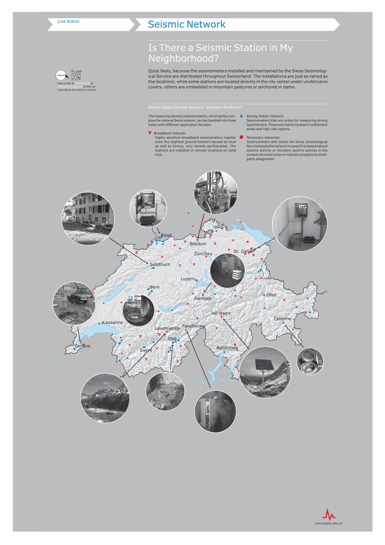
Is There a Seismic Station in My Neighborhood?Quite likely, because the seismometers installed and maintained by the Swiss Seismolog-ical Service are distributed throughout Switzerland. The installations are just as varied as the locations: while some stations are located directly in the city center under unobtrusive covers, others are embedded in mountain pastures or anchored in dams.
Which Tasks Do the Seismic Stations Perform?
The measuring devices (seismometers), which jointly com-pose the national Swiss network, can be classified into three types with different application focuses:
even the slightest ground tremors caused by local as well as strong, very remote earthquakes. The stations are installed in remote locations on solid rock.
Strong motion network: Seismometers that are suited for measuring strong
local tremors. These are mainly located in settlement areas and high-risk regions.
Temporary networks: Seismometers with which the Swiss Seismological
Service boosts the network in case of increased natural seismic activity or monitors seismic activity in the context of construction or industry projects by third-party assignment.
""
"
""
"
")"
Chur
Bern
Basel
Sierre
Luzern
Zürich
Lausanne
Bellinzona
St. Gallen
Genève
Solothurn
Bannalp
Böbikon
Val Nalps
FiescheralpLauchneralp
Visp
Celerina
www.
Have a look at Snapshot 06 at www.seismo.ethz.ch to find out more about the seismic network.
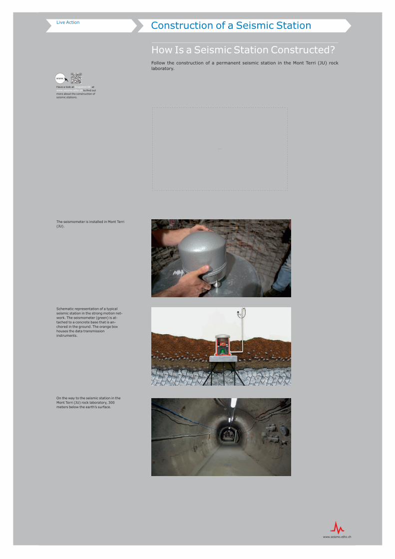
Construction of a Seismic StationLive Action
How Is a Seismic Station Constructed?Follow the construction of a permanent seismic station in the Mont Terri (JU) rock laboratory.
The seismometer is installed in Mont Terri (JU).
Schematic representation of a typical seismic station in the strong motion net-work. The seismometer (green) is at-tached to a concrete base that is an-chored in the ground. The orange box houses the data transmission instruments.
On the way to the seismic station in the Mont Terri (JU) rock laboratory, 300 meters below the earth’s surface.
www.
Have a look at Snapshot 06 at www.seismo.ethz.ch to find out more about the construction of seismic stations.
Monitor
Effects
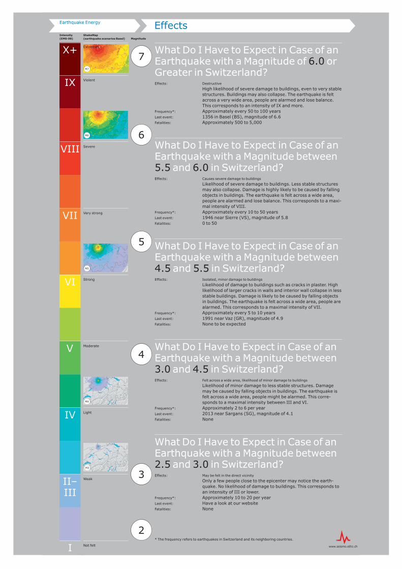
What Do I Have to Expect in Case of an Earthquake with a Magnitude of 6.0 or Greater in Switzerland?Effects: Destructive
High likelihood of severe damage to buildings, even to very stable structures. Buildings may also collapse. The earthquake is felt across a very wide area, people are alarmed and lose balance. This corresponds to an intensity of IX and more.
Frequency*: Approximately every 50 to 100 yearsLast event: 1356 in Basel (BS), magnitude of 6.6Fatalities: Approximately 500 to 5,000
What Do I Have to Expect in Case of an Earthquake with a Magnitude between 5.5 and 6.0 in Switzerland?Effects: Causes severe damage to buildings
Likelihood of severe damage to buildings. Less stable structures may also collapse. Damage is highly likely to be caused by falling objects in buildings. The earthquake is felt across a wide area, people are alarmed and lose balance. This corresponds to a maxi-mal intensity of VIII.
Frequency*: Approximately every 10 to 50 yearsLast event: 1946 near Sierre (VS), magnitude of 5.8Fatalities: 0 to 50
What Do I Have to Expect in Case of an Earthquake with a Magnitude between 4.5 and 5.5 in Switzerland?Effects: Isolated, minor damage to buildings
Likelihood of damage to buildings such as cracks in plaster. High likelihood of larger cracks in walls and interior wall collapse in less stable buildings. Damage is likely to be caused by falling objects in buildings. The earthquake is felt across a wide area, people are alarmed. This corresponds to a maximal intensity of VII.
Frequency*: Approximately every 5 to 10 yearsLast event: 1991 near Vaz (GR), magnitude of 4.9 Fatalities: None to be expected
What Do I Have to Expect in Case of an Earthquake with a Magnitude between 3.0 and 4.5 in Switzerland?Effects: Felt across a wide area, likelihood of minor damage to buildings
Likelihood of minor damage to less stable structures. Damage may be caused by falling objects in buildings. The earthquake is felt across a wide area, people might be alarmed. This corre-sponds to a maximal intensity between III and VI.
Frequency*: Approximately 2 to 6 per year Last event: 2013 near Sargans (SG), magnitude of 4.1 Fatalities: None
What Do I Have to Expect in Case of an Earthquake with a Magnitude between 2.5 and 3.0 in Switzerland?Effects: May be felt in the direct vicinity
Only a few people close to the epicenter may notice the earth-quake. No likelihood of damage to buildings. This corresponds to an intensity of III or lower.
Frequency*: Approximately 10 to 20 per yearLast event: Have a look at our websiteFatalities: None
ShakeMap (earthquake scenarios Basel)
Intensity(EMS-98) Magnitude
7
2
3
4
5
6
X+
IX
V
IV
I
II– III
Violent
VIII Severe
VII Very strong
VI Strong
Moderate
Light
Weak
Not felt
Extreme
Earthquake Energy
M7
M6
M5
M4
M3
* The frequency refers to earthquakes in Switzerland and its neighboring countries.
MagnitudeGlobal annual frequency
Strength
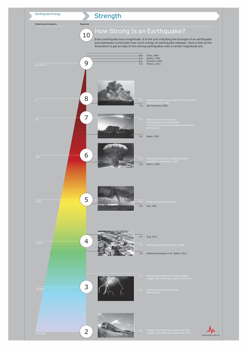
How Strong Is an Earthquake?Every earthquake has a magnitude. It is the unit indicating the strength of an earthquake and expresses numerically how much energy an earthquake releases. Have a look at the illustration to get an idea of how strong earthquakes with a certain magnitude are.
8.1 Released energy at the eruption of the Mount St.
Helens volcano, 19807.8 San Francisco, 1906
6.9 Momentum of the meteorite that exploded over Chelyabinsk in Russia in 2013 (prior to entering the earth’s atmosphere)
6.6 Basel, 1356
5.9 Explosive force of the nuclear bomb that exploded in Hiroshima in 1946
5.8 Sierre, 1946
5.0 Force of an average tornado
4.9 Vaz, 1991
4.2 Zug, 2012
3.9 Nuclear accident in Chernobyl, 1986
3.6 Geothermal project in St. Gallen, 2013
3.4 Energy required to move an Airbus A380 (weight: 500 metric tons, speed: 910 km/h)
2.8 Energy released by an average lightning bolt
2.0 Energy required to move a suburban train (weight: 225 metric tons, speed: 85 km/h)1,000,000
100,000
10,000
1,500
150
18
8
less than 1
Earthquake Energy
EnergyEarthquake Energy
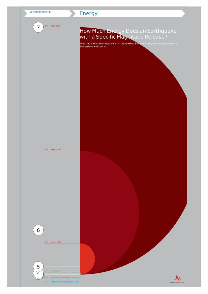
23
7.0 Haiti, 2010
5.8 Sierre, 1946
4.2 Zug, 2012
3.6 Geothermal project in St. Gallen, 2013
3.4 Geothermal project in Basel, 2006
7
6
45
6.6 Basel, 1356
How Much Energy Does an Earthquake with a Specific Magnitude Release?The sizes of the circles represent the energy that different earthquakes have released in Switzerland and abroad.
Local SubsoilEarthquake Risk
What Makes Up the Earthquake Risk?The seismic risk is made up of four components: the seismic hazard, the local subsoil, the factors describing the affected assets (population density and space utilization), and their vulnerability (type and quality of building construction and infrastructure).
How Does the Local Subsoil Influence the Earthquake Risk?Soft soils especially increase those wave types that cause the worst damage to buildings. A building constructed on rocky ground therefore suffers less damage through earthquakes than the same building erected on sediments.
ExperimentLightly hit the short side of the model with the hammer and watch what happens to the buildings.
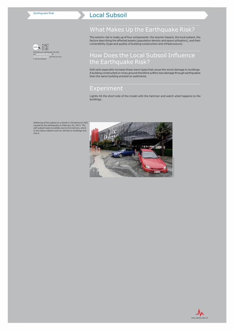
Softening of the subsoil on a street in Christchurch (NZ) caused by the earthquake on February 22, 2012. The soft subsoil loses its solidity due to the tremors, which is why heavy objects such as vehicles or buildings sink into it.
Estimate your earthquake risk with our earthquake risk tool at
www.seismo.ethz.ch and find out how it can be reduced.
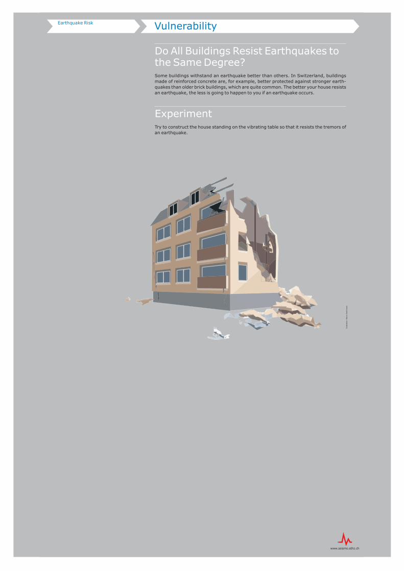
Do All Buildings Resist Earthquakes to the Same Degree?Some buildings withstand an earthquake better than others. In Switzerland, buildings made of reinforced concrete are, for example, better protected against stronger earth-quakes than older brick buildings, which are quite common. The better your house resists an earthquake, the less is going to happen to you if an earthquake occurs.
ExperimentTry to construct the house standing on the vibrating table so that it resists the tremors of an earthquake.
Illu
stra
tion
: M
ario
n D
eich
man
n
Hazard and ValuesEarthquake Risk
Experiment
How Does Seismic Hazard Influence the Risk?Seismic hazard describes the likelihood with which a certain ground acceleration can be expected in a specific location within a specific period of time. The seismic hazard map shows where stronger earthquakes are to be expected in Switzerland.
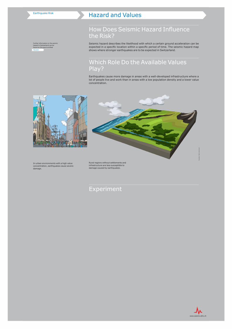
Which Role Do the Available Values Play?Earthquakes cause more damage in areas with a well-developed infrastructure where a lot of people live and work than in areas with a low population density and a lower value concentration.
Rural regions without settlements and infrastructure are less susceptible to damage caused by earthquakes.
In urban environments with a high value concentration, earthquakes cause severe damage.
Further information on the seismic hazard in Switzerland can be found on the panel entitled
Hazard
Illu
stra
tion
: M
ario
n D
eich
man
n
Art
What Are Earthquakes Doing in Art?Quite a bit … Listen to the sounds of earthquakes, look at pictures and photographs inspired by the movements of earthquakes, or immerse yourself in the world of dance.
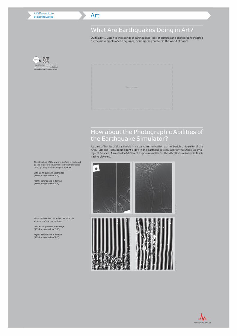
How about the Photographic Abilities of the Earthquake Simulator?As part of her bachelor’s thesis in visual communication at the Zurich University of the Arts, Ramona Tschuppert spent a day in the earthquake simulator of the Swiss Seismo-logical Service. As a result of different exposure methods, the vibrations resulted in fasci-nating pictures.
The structure of the water’s surface is captured by the exposure. The image is then transferred directly to light-sensitive photo paper.
Left: earthquake in Northridge (1994, magnitude of 6.7).
Right: earthquake in Taiwan (1999, magnitude of 7.6).
The movement of the water deforms the structure of a stripe pattern.
Left: earthquake in Northridge (1994, magnitude of 6.7).
Right: earthquake in Taiwan (1999, magnitude of 7.6).
Have a look at Snapshot 04 at www.seismo.ethz.ch to fi nd out more about earthquakes in art.
www.
Touch screen
A Mountain of Data
How Large Is the Annual Mountain of Data Collected by the Swiss Seismological Service?Seismologists are keen collectors of data: their networks of seismometers allow them to map even the slightest ground movements. The mountain of data collected in Switzerland alone has an annual volume of two to three terabytes. This comes to more than 3,000 gigabytes.
What Is the Best Way to Obtain Good Data?
Good data, meaning high-quality scientific data, is pro-duced by especially dense seismic networks equipped with high-quality measuring devices: the denser the net-work and the better the measuring devices are, the small-er the earthquakes that can be reliably recorded.
Every day, the Swiss seismic network even records mul-tiple earthquakes that are too weak to be felt. The record-ing quality in highly seismically active areas such as California and Japan is as good or better, but there are
still earthquakes that go undiscovered under the world’s oceans that would be strong enough to cause minor dam-age if they took place in a city.
If enough seismometers could be distributed around the world to record all of the earthquakes with a magnitude of 2.0 or higher, there would be around one and a half million earthquakes a year, with one happening every 20 seconds on average.
What Does This Mountain of Data Serve For?Certain patterns can be identified using the large quantity of seismic data. They allow us to draw conclusions about the size distribution and geographical distribution of earth-quakes. This information, in turn, serves as the basis for risk analysis and research into the exact causes and mechanisms of earthquakes.
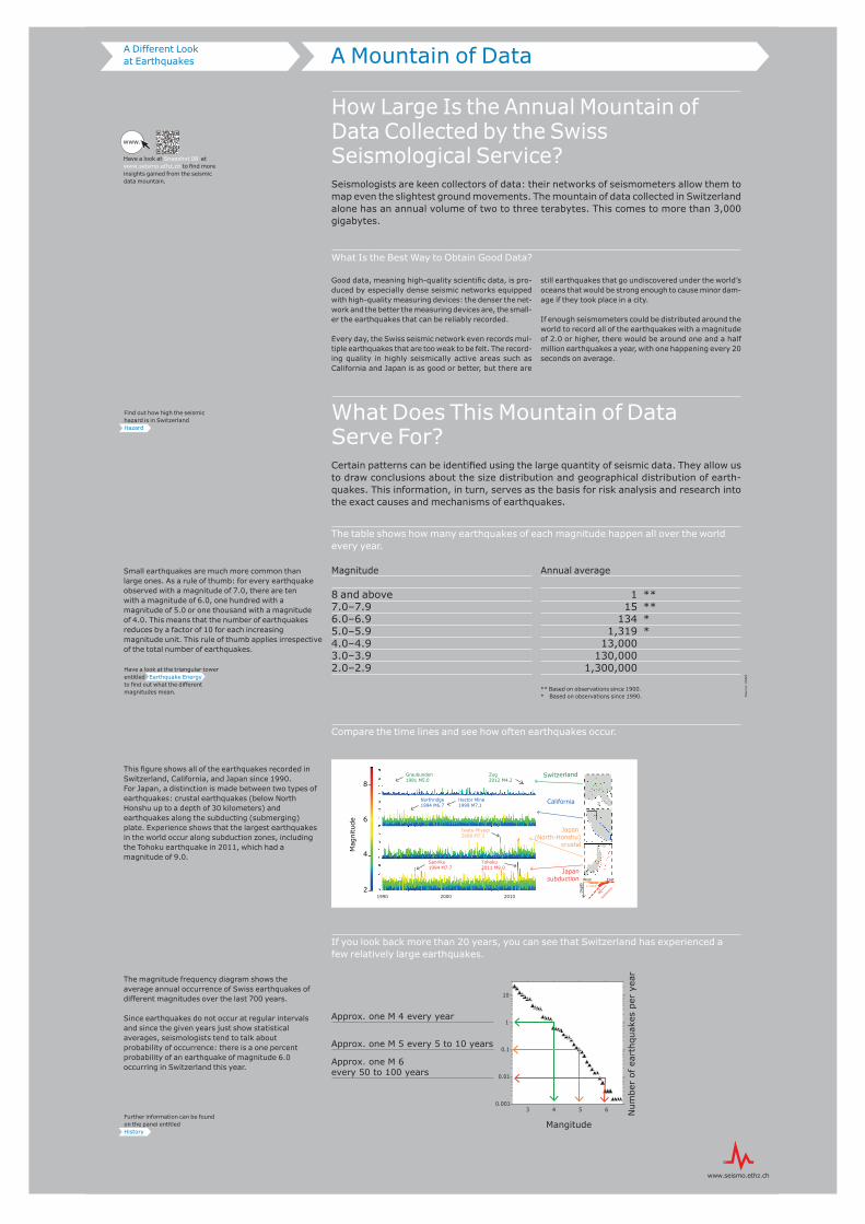
Magnitude
8 and above7.0–7.96.0–6.95.0–5.94.0–4.93.0–3.92.0–2.9
Annual average
1 ** 15 ** 134 * 1,319 * 13,000 130,000 1,300,000
** Based on observations since 1900.* Based on observations since 1990.
Small earthquakes are much more common than large ones. As a rule of thumb: for every earthquake observed with a magnitude of 7.0, there are ten with a magnitude of 6.0, one hundred with a magnitude of 5.0 or one thousand with a magnitude of 4.0. This means that the number of earthquakes reduces by a factor of 10 for each increasing magnitude unit. This rule of thumb applies irrespective of the total number of earthquakes.
This figure shows all of the earthquakes recorded in Switzerland, California, and Japan since 1990. For Japan, a distinction is made between two types of earthquakes: crustal earthquakes (below North Honshu up to a depth of 30 kilometers) and earthquakes along the subducting (submerging) plate. Experience shows that the largest earthquakes in the world occur along subduction zones, including the Tohoku earthquake in 2011, which had a magnitude of 9.0.
The magnitude frequency diagram shows the average annual occurrence of Swiss earthquakes of different magnitudes over the last 700 years.
Since earthquakes do not occur at regular intervals and since the given years just show statistical averages, seismologists tend to talk about probability of occurrence: there is a one percent probability of an earthquake of magnitude 6.0 occurring in Switzerland this year.
0.001
0.01
0.1
1
10
3 4 5 6
Approx. one M 4 every year
Approx. one M 5 every 5 to 10 years
Approx. one M 6 every 50 to 100 years
Mangitude
Num
ber
of e
arth
quak
es p
er y
ear
A Different Look at Earthquakes
Further information can be found on the panel entitled History
Have a look at the triangular tower entitled Earthquake Energy to find out what the different magnitudes mean.
Find out how high the seismic hazard is in Switzerland Hazard
Sou
rce:
USG
S
The table shows how many earthquakes of each magnitude happen all over the world every year.
Compare the time lines and see how often earthquakes occur.
If you look back more than 20 years, you can see that Switzerland has experienced a few relatively large earthquakes.
Have a look at Snapshot 08 at www.seismo.ethz.ch to find more insights gained from the seismic data mountain.
www.
8
6
4
2
Mag
nitu
de
Switzerland
Japan (North-Honshu)
crustal
Japan subduction
California
Graubunden 1991 M5.0
Northridge1994 M6.7
Hector Mine1999 M7.1
Tohoku2011 M9.0
Iwate-Miyagi2008 M7.2
Sanriku1994 M7.7
Zug2012 M4.2
$$
Dep
th
West Eastcrustal
subd
uctio
n
1990 2000 2010
Mars
What Is InSight?
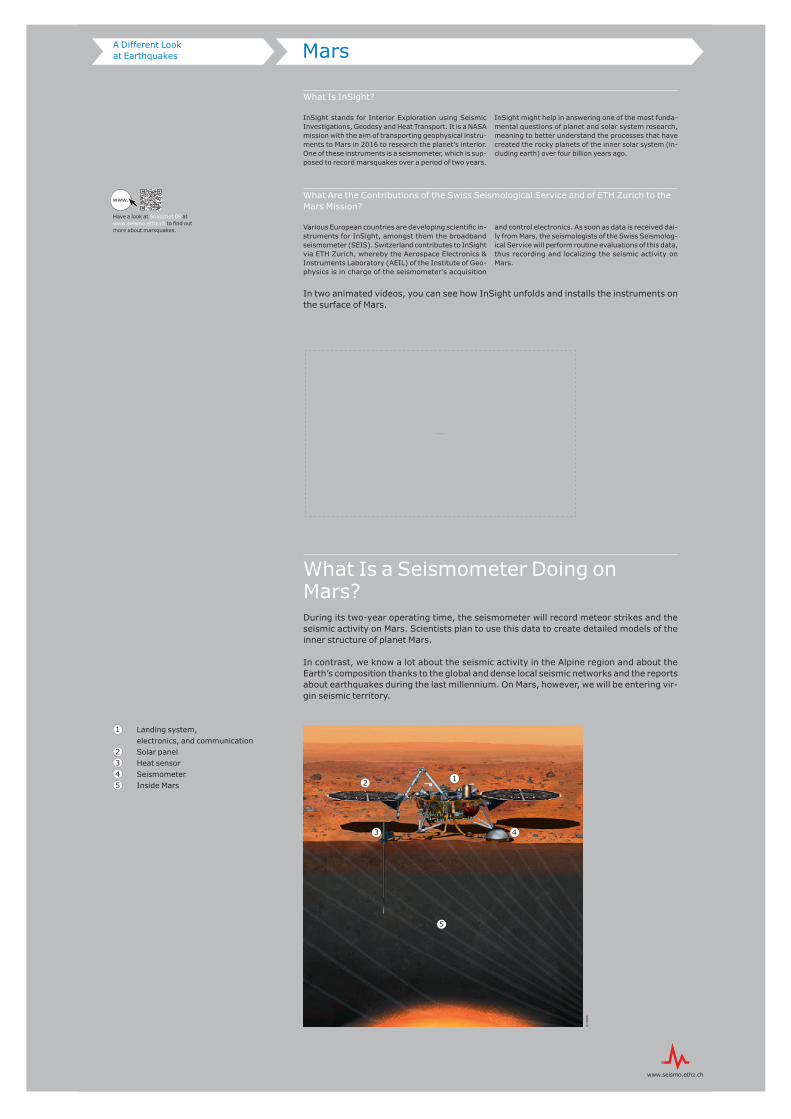
InSight stands for Interior Exploration using Seismic Investigations, Geodesy and Heat Transport. It is a NASA mission with the aim of transporting geophysical instru-ments to Mars in 2016 to research the planet’s interior. One of these instruments is a seismometer, which is sup-posed to record marsquakes over a period of two years.
InSight might help in answering one of the most funda-mental questions of planet and solar system research, meaning to better understand the processes that have created the rocky planets of the inner solar system (in-cluding earth) over four billion years ago.
What Are the Contributions of the Swiss Seismological Service and of ETH Zurich to the Mars Mission?
Various European countries are developing scientific in-struments for InSight, amongst them the broadband seismometer (SEIS). Switzerland contributes to InSight via ETH Zurich, whereby the Aerospace Electronics & Instruments Laboratory (AEIL) of the Institute of Geo-physics is in charge of the seismometer’s acquisition
and control electronics. As soon as data is received dai-ly from Mars, the seismologists of the Swiss Seismolog-ical Service will perform routine evaluations of this data, thus recording and localizing the seismic activity on Mars.
In two animated videos, you can see how InSight unfolds and installs the instruments on the surface of Mars.
What Is a Seismometer Doing on Mars?During its two-year operating time, the seismometer will record meteor strikes and the seismic activity on Mars. Scientists plan to use this data to create detailed models of the inner structure of planet Mars.
In contrast, we know a lot about the seismic activity in the Alpine region and about the Earth’s composition thanks to the global and dense local seismic networks and the reports about earthquakes during the last millennium. On Mars, however, we will be entering vir-gin seismic territory.
Landing system, electronics, and communication Solar panel Heat sensor Seismometer Inside Mars
Have a look at Snapshot 09 at www.seismo.ethz.ch to find out more about marsquakes.
www.
Monitor
Maps(inside the rotunda)
Tectonics
The tectonic map shows the geological units on Swiss territory together with the known fault lines and rupture zones in the Earth’s crust. These occur because the tectonic plates rub against each other, and through tension in these plates.
Earthquakes
Epicenters of all earthquakes in Switzerland with a magnitude of 2.0 or greater since 1975.
Historic Earthquakes
Earthquakes with a magnitude of 4 or greater since the year 250. The bigger the circle, the stronger the earthquake, the brighter the color, the older the earthquake.
Seismic Hazard
The seismic hazard specifies the probability that a specific ground acceleration will occur at a specific place within a specific period. The redder the region on the map, the higher the hazard in this region.
Part 3:
Zug 2012 ShakeMap
ShakeMap of the earthquake with a magnitude of 4.2 near Zug in 2012. A ShakeMap depicts the ground shaking on the surface triggered by an earthquake. The Swiss Seismological Service publishes a ShakeMap for every earthquake with a magnitude of 2.5 or greater.
Sierre 1946 ShakeMap
Expected ShakeMap if an earthquake with magnitude 5.8 was to strike Sierre today. A ShakeMap depicts the ground shaking on the surface triggered by an earthquake. The Swiss Seismological Service publishes a ShakeMap for every earthquake with a magnitude of 2.5 or greater.
Basel 1356 ShakeMap
Expected ShakeMap if an earthquake with magnitude 6.6 was to strike Basel today. A ShakeMap depicts the ground shaking on the surface triggered by an earthquake. The Swiss Seismological Service publishes a ShakeMap for every earthquake with a magnitude of 2.5 or greater.
Seismic Network
The Swiss seismic network incorporates more than 100 seismic stations. Broadband seismometers (red) register even the slightest ground tremors caused by weak, local as well as strong, very remote earthquakes. Strong-motion seismometers (blue) are especially suited for measuring strong local tremors. Temporary networks (yellow) serve to densify the permanent network in case of increased natural seismic activity or to monitor any seismic activity in the context of construction or industry projects. Seismo@School stations (orange) are installed for teaching purposes in schools.
Animations(inside the rotunda)
Earthquakes in Switzerland
The animation shows the epicenters of the earthquakes with a magnitude of 2.5 or greater from 1975 to 2014 recorded with the corresponding instruments.
Every year, between 500 and 800 earthquakes occur in Switzerland. Around 10 of those are strong enough (magnitude of approximately 2.5 or greater) to be noticed by the population.
Earthquake Swarm in Diemtigen in 2014
Since April 13, 2014, the Swiss Seismological Service registered over 150 earthquakes with magnitudes between –0.1 and 2.7 near Diemtigen.In earthquake swarms numerous tremors occur over a longer period without a clear sequence of foreshocks, main shocks, and aftershocks. Swarm activities usually end after a few weeks or months; in rare cases, the strength and number of the tremors increase over time.
Induced Seismicity, Geothermal Energy Project in St. Gallen
Induced seismicity occurs when geotechnical interference changes the tension in the subsoil. In deep geothermal energy projects, numerous small earthquakes are often intentionally triggered to increase the permeability of the rock and thus the profitability of a project.
The animation shows all earthquakes in 2013 and 2014 that occurred in the region of the geothermal energy project near St. Gallen, which has been shelved for the time being.
Part 4:
Seismic Network
The animation shows the development of the seismic network from 1989 to 2014.
Broadband seismometers register even the slightest ground tremors caused by weak, local as well as strong, very remote earthquakes. Strong-motion seismometers are especially suited for measuring strong local tremors.
Spread of Seismic Waves
Computer simulation of the earthquake with a magnitude of 5.8 near Sierre in 1946. The redder the seismic waves, the stronger the tremors that occurred in this region.