85
Unit 3. Flood BCA Module 3-1 Unit 3 FEMA Flood Module

Unit 3. Flood BCA Module 3-1
Unit 3
FEMA Flood Module
Unit 3. Flood BCA Module 3-2
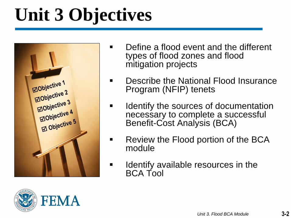
Unit 3 Objectives
Define a flood event and the different types of flood zones and flood mitigation projects
Describe the National Flood Insurance Program (NFIP) tenets
Identify the sources of documentation necessary to complete a successful Benefit-Cost Analysis (BCA)
Review the Flood portion of the BCA module
Identify available resources in the BCA Tool

Unit 3. Flood BCA Module
Flood depths = flood elevations minus FFE
First Floor Elevation (FFE)
Flood Elevations
(10-, 50-, 100-, 500- years)
Flood Damages
3-3
Flood Module Overview
Flood depths = flood elevations minus FFE

Unit 3. Flood BCA Module 3-4-4
Flood Statistics
Floods are the most common, most predictable, and most
costly of all natural disasters in the United States
90 percent of all presidential disaster declarations involve
flooding
Congress established the NFIP in 1968 to regulate affordable
flood insurance for communities in flood-prone areas
Through NFIP, FEMA has identified and mapped out more
than 21,000 communities

Unit 3. Flood BCA Module 3-5
Obtaining Riverine Data

Unit 3. Flood BCA Module -63-6
Flood Terminology Review Activity
Match the terms and
their definitions.
When you think that
you have the correct
answers, let the
instructor know.

Unit 3. Flood BCA Module 3-7
BCA Information Provided by a FIRM
A FIRM provides important BCA data inputs:
If the property is in the Special Flood Hazard Area (SFHA)
Flood zone
Base Flood Elevation (BFE) for the property
Community number, map panel and effective date

Unit 3. Flood BCA Module 3-8
How to Read a Flood Insurance Rate Map (FIRM)

Unit 3. Flood BCA Module 3-9
How to Read a FIRM
The FEMA FIRM Tutorial is a step-by-step process that you may
follow to obtain hazard-specific information on a FIRM. The tutorial
educates users on the use and application of FEMA FIRMs.
The full tutorial can be found at
http://www.fema.gov/media/fhm/firm/ot_firm.htm
This tutorial will help the user:
Find the correct FIRM panel
Find the general location of a property
Find the specific location of a property
Identify the flood insurance risk zone designation

Unit 3. Flood BCA Module 3-10
How to Read a FIRM (continued)
Step 1: Find the
Correct Panel
Use the index to find
the FIRM panel you
need. This sample
index is composed of
four panels (0001,
0002, 0003, and 0004).
Determine the general
area of your property
and locate it on the
index. Check the title
boxes on the panels to
find the panel you need
– panel 0004 in this
example.

Unit 3. Flood BCA Module 3-11
How to Read a FIRM (continued)
Step 2: Find the General
Location
After obtaining panel
0004, find the general
location by referring to
features such as major
roads or city limits.

Unit 3. Flood BCA Module 3-12
How to Read a FIRM (continued)
Step 3: Find the Specific
Location of the Property
To find the specific location
and dimensions of the
property refer to:
A plat map,
A tax assessor’s map, or
The property description on the deed.
Then convert the known
property dimensions to inches
using the flood map scale and
measurements on the flood
map panel.

Unit 3. Flood BCA Module 3-13
How to Read a FIRM (continued)
Step 4: Identify the Flood
Insurance Risk Zone of the
Property
As shown on the map on the
right, the property you are
considering buying is partially
within the dark-tinted SFHA.
Identify the flood insurance risk
zone designation for the
property by finding the labeled
zone.
The SFHA near the property is
labeled Zone AE.

Unit 3. Flood BCA Module 3-14
Obtaining Data from a Flood Insurance Study (FIS)

Unit 3. Flood BCA Module 3-15
BCA Information Provided by a Flood Insurance Study
A FIS provides important BCA data inputs:
Flood elevation data from flood profiles
Streambed elevation
Flood discharges
Unit 3. Flood BCA Module 3-16
Obtaining Riverine Data
This section outlines a step-by-step process to obtain hazard-specific
information from a FIRM and a FIS that are needed to complete a
comprehensive BCA
The full FEMA tutorial can be found at
http://www.fema.gov/media/fhm/fis/ot_fis.htm
This tutorial will help the user:
Locate and effectively use a FIS flood profile
Understand and identify flood frequencies
Determine the BFE and Streambed Elevation of a riverine property
Locate flood discharge data

Unit 3. Flood BCA Module 3-17
Flood Profiles
A flood profile is a graph of the flood elevations along the centerline of a stream. Flood profiles show the predicted water surface elevation for the 100-year-flood event (1-percent-annual chance), and often show the flood elevation profiles for the 10-, 50- and 500-year (equal to the 10-, 2-, and 0.2-percent annual chance, respectively) flood events.
Other information shown on the flood profiles include:
Location of flood map cross sections (a letter within a hexagon)
Location of streets crossing streams
Streambed elevation
Flood profiles should be used to determine the precise BFE for an area in the floodplain, rather than the FIRM, where the BFEs are rounded to the nearest whole foot. Precise streambed elevations can be derived using this same method.

Unit 3. Flood BCA Module 3-18
Obtaining Riverine Base Flood Elevations (BFE)
Step 1: Locate the property ( ) on the Flood Insurance Rate Map and
identify the flooding source

Unit 3. Flood BCA Module 3-19
Obtaining Riverine BFEs (continued)
Step 2: Locate the boundary of the property. Locate a physical feature
near the site that appears on the flood profile, such as a road or an
intersection.
Unit 3. Flood BCA Module 3-20
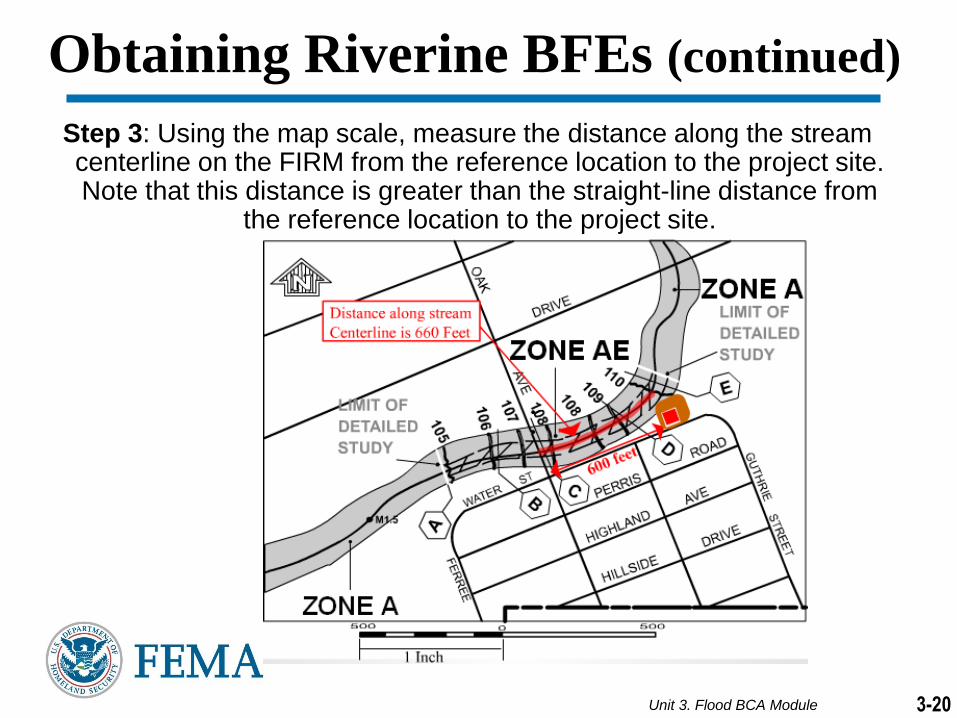
Obtaining Riverine BFEs (continued)
Step 3: Using the map scale, measure the distance along the stream centerline on the FIRM from the reference location to the project site. Note that this distance is greater than the straight-line distance from
the reference location to the project site.

Unit 3. Flood BCA Module 3-21
Obtaining Riverine BFEs (continued)
Step 4: Measure the distance from the reference location (e.g., road or
intersection) to the site on the profile.

Unit 3. Flood BCA Module 3-22
Obtaining Riverine BFEs (continued)
Step 5: Draw a vertical line to find where the site intersects the flood
profiles.

Unit 3. Flood BCA Module 3-23
Obtaining Riverine BFEs (continued)
Step 6: Draw a straight line to the edge of the graph to determine the
elevations for each of the 10-, 50-, 100-, and 500-year flood profiles
at the project site.

Unit 3. Flood BCA Module 3-24
Obtaining Streambed Elevation
The streambed, or the bottom of a stream below the water source,
provides a baseline for riverine measurement.
The Streambed Elevation is easily located on the flood profile by the
symbol indicated below and can be determined using the same
method as you would the BFE.

Unit 3. Flood BCA Module 3-25
Obtaining Flood Discharge Data
The Summary of Discharges Table lists the peak water discharges for
various flood frequencies at locations within the study area.
For example, using the summary of discharges table below, the 100-year
flood discharge for Cobb Brook at the confluence with the Rocky River is
1,080 cubic feet per second (cfs). This means that during the peak of the
100-year flood, 1,080 cubic feet of water will pass this point each second.

Unit 3. Flood BCA Module 3-26
Peak Discharges for a Site
To determine the peak discharges for a specific site:
Locate the flooding source identified for the project site on the
Summary of Discharges table (within the community’s FIS).
Identify the closest physical location to the project site that is listed
for the flooding source.
Enter the peak discharges for the closest location to the site for the
10-, 50-, 100-, and 500-year floods into the BCA Tool.
Unit 3. Flood BCA Module 3-27
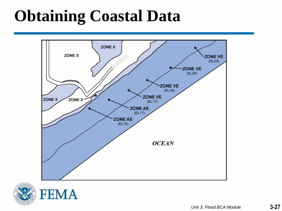
Obtaining Coastal Data

Unit 3. Flood BCA Module 3-28
Coastal Stillwater Elevation
Most coastal floods are caused by coastal storms, usually hurricanes and
northeasters. Such storms bring air pressure changes and strong winds
that pile water up against the shore in what is called a storm surge.
Based on data from past storms, computer models simulate coastal storms
to determine the Stillwater Elevation -- the elevation of coastal floods
without waves.
Stillwater Elevations are found in the Summary of Stillwater Elevations
table in a FIS, typically in Section 3.

Unit 3. Flood BCA Module 3-29
As with riverine studies, a hydraulic analysis determines where moving water
goes. The coastal flood engineering survey uses techniques similar to those
used in a riverine study, but it uses transects instead of cross sections.
Transects

Unit 3. Flood BCA Module 3-30
Wave Runup
In addition to storm surge, wave action is an important aspect of
coastal storms. Wind-driven waves produce water velocities and
impacts that may cause significant structural damage.
When waves hit the shore, water moves with such force that it
keeps traveling inland, called wave runup.
The official BFE of coastal areas is the Stillwater Elevation plus
wave runup, or the wave crest elevation, whichever is greater. The
resulting BFE can be many feet higher than the Stillwater Elevation.

Unit 3. Flood BCA Module 3-31
Obstructions such as dunes or buildings break waves, dissipating the wave
energy so that wave height and BFEs are reduced as you go inland.
Coastal Obstructions

Unit 3. Flood BCA Module 3-32
Coastal High Hazard Area
Coastal High Hazard
Areas are the most
hazardous part of the
coastal floodplain due
to their exposure to
wave effects. These
areas are designated
as V Zones where the
"V" stands for "velocity
wave action," and
includes an increased
degree of risk. Coastal
flood areas not within
the coastal high hazard
area are mapped as A
Zones.

Unit 3. Flood BCA Module 3-33
Obtaining Coastal Data
Step 1: Locate the property and read the flood zone and BFE on a
FIRM. The BFE is listed in parentheses below the zone label. Unlike
Riverine properties, the BFE cannot be found in an FIS Flood Profile.
Property Location

Unit 3. Flood BCA Module 3-34
Obtaining Coastal Data
Step 2: Locate the property on the Transect Location Map in the FIS.
A description of the start of the transects can be found on the
Transect Location Map.
Property Location

Unit 3. Flood BCA Module 3-35
Obtaining Coastal Data
Step 3: Find the 100-year Stillwater Elevations at the start of the two
transects nearest the property in the Transect Data Table in the FIS.
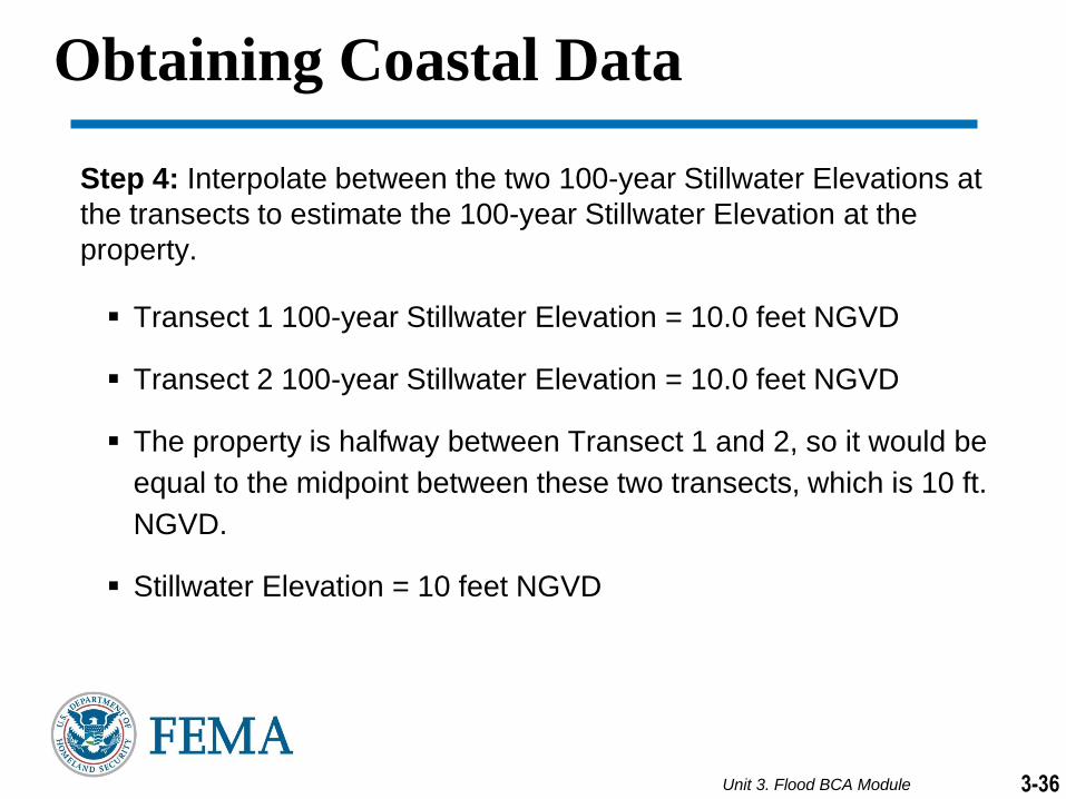
Unit 3. Flood BCA Module 3-36
Obtaining Coastal Data
Step 4: Interpolate between the two 100-year Stillwater Elevations at
the transects to estimate the 100-year Stillwater Elevation at the
property.
Transect 1 100-year Stillwater Elevation = 10.0 feet NGVD
Transect 2 100-year Stillwater Elevation = 10.0 feet NGVD
The property is halfway between Transect 1 and 2, so it would be
equal to the midpoint between these two transects, which is 10 ft.
NGVD.
Stillwater Elevation = 10 feet NGVD

Unit 3. Flood BCA Module
Flood BCA Data Inputs and Documentation
3-37

Unit 3. Flood BCA Module
Data Documentation Template
Reminder: the Flood Data Documentation Template gives you
potential data sources and can be used as a data checklist
3-38

Unit 3. Flood BCA Module 3-39
Flood BCA Tool File Path
Mitigation Project Type
Mitigation Project Cost
Hazard-Specific Data
Structure Information
Depth Damage
Functions

Unit 3. Flood BCA Module 3-40
Flood BCA Documentation: General Guidance
Data used in place of
FEMA standards or
default values MUST
be documented
Documentation should include
justification for the use of data in
place of FEMA values.
Hydrologic and hydraulic analyses
Building Replacement and Contents Values
Elevation Certificate(s)
All data must be obtained
from a credible source
Federal, State, county, regional, and local
government agencies
Qualified professionals such as licensed
architects, engineers, and surveyors

Unit 3. Flood BCA Module 3-41
Flood BCA Tool File Path
Mitigation Project Type

Unit 3. Flood BCA Module 3-42
Mitigation Project Types
Acquisition
The purchase and demolition of a building. Future damage is eliminated because the project site is deed-restricted as open space.
Elevation
The raising of a building on an extended foundation or fill to place the lowest floor at or above the designated flood elevation.

Unit 3. Flood BCA Module 3-43
Mitigation Project Types
Dry Flood Proofing/Flood Barrier
Mitigation measures added or
incorporated into an asset to
prevent flood damage by
making the exterior walls
impermeable to floodwater.
Drainage Improvement
An activity within or adjacent to
a flood source intended to
improve the flow capacity,
drainage, erosion and
sedimentation control, or
stability.

Unit 3. Flood BCA Module 3-44
Flood BCA Tool File Path
Mitigation Project Type
Mitigation Project Cost

Unit 3. Flood BCA Module 3-45
Mitigation Project Cost
Unit II: Estimating Costs and Benefits
Pre-construction, Construction, Ancillary, and Annual Maintenance Costs
Sources:
Local historical cost data
Current contractor bids
Cost estimating software
Flood BCA Documentation: Mitigation Project Cost

Unit 3. Flood BCA Module 3-46
Flood BCA Tool File Path
Mitigation Project Type
Mitigation Project Cost
Hazard-Specific Data

Unit 3. Flood BCA Module 3-47
FIS and/or Hydrology and Hydraulics (H&H) Study
Riverine: Flood Profile, Streambed Elevation, Discharges
Coastal: Stillwater Elevation (SWEL), BFE or 100-year elevation including wave action
FIRM
Panel Number, Effective Date, Community ID Number
Flood BCA Documentation: Hazard-Specific Data

Unit 3. Flood BCA Module 3-48
Flood BCA Tool File Path
Mitigation Project Type
Mitigation Project Cost
Hazard-Specific Data
Structure Information
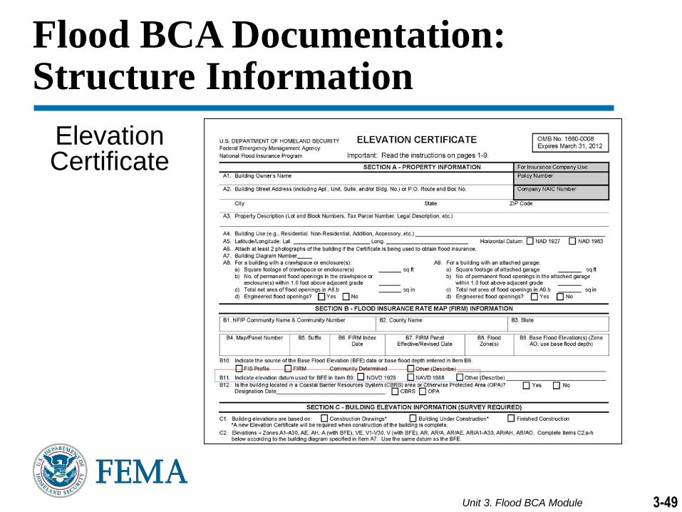
Unit 3. Flood BCA Module 3-49
Elevation Certificate
Flood BCA Documentation: Structure Information

Unit 3. Flood BCA Module 3-50
SECTION B: FLOOD INSURANCE RATE MAP (FIRM) INFORMATION
B1: NFIP Community Name & Community Number
B2: County Name
B3: State
B4: Map/Panel Number
B5: Suffix
Flood BCA Documentation: Structure Information
B6: FIRM Index Date
B7: Firm Panel Effective Date/Revised Date
B8: Flood Zone(s)
B9: BFE(s) (Zone AO, use base flood depth)

Unit 3. Flood BCA Module 3-51
SECTION C: BUILDING ELEVATION INFORMATION (SURVEY REQUIRED)
a) Top of bottom floor (including basement, crawlspace, or enclosure floor
b) Top of the next higher floor
c) Bottom of the lowest horizontal structural member (V Zones only)
Flood BCA Documentation: Structure Information

Unit 3. Flood BCA Module 3-52
Other Sources of Structure Elevation Data
Professional Surveyor
Estimated elevation from a known
elevation of neighboring structure
Estimated elevation from high-
resolution topographic data (i.e.,
LiDAR)

Unit 3. Flood BCA Module 3-53
Flood BCA Documentation:Structure Type and FFE
First Floor Elevation (FFE)
Finished Basement
Unfinished Basement
Finished Walkout Basement

Unit 3. Flood BCA Module 3-54
Size of Building
Measured in square feet
Sources
Building Replacement Value
Cost per square foot to build a comparable structure
Sources
Flood BCA Documentation: Structure Information
Unit 3. Flood BCA Module 3-55
Foundation/Building Type, Number of Stories
What are some acceptable forms of documentation?
Where can you obtain them?
Flood BCA Documentation: Residential Structure

Unit 3. Flood BCA Module 3-56
Primary Use of Building / Number of Stories
Sources: owner, local building inspector, local tax assessor’s office,
or title documents on letterhead from a credible source
Service Types by Facility (Value of Public Service)/Annual Budget
Service Name Examples: government, library, education, hospital,
emergency medical service (EMS), safe room, fire, police, or
Emergency Operations Center
Sources: agency providing service or published annual report
Flood BCA Documentation: Non-residential Structure

Unit 3. Flood BCA Module 3-57
Flood BCA Tool File Path
Mitigation Project Type
Mitigation Project Cost
Hazard-Specific Data
Structure Information
Depth Damage
Functions

Unit 3. Flood BCA Module 3-58
Flood BCA Documentation: Depth Damage Functions
Depth Damage Functions
Choose from three options
Default
Library
Custom
If FEMA Standard Value is not used, sources include: historical loss records and engineering judgments
Mitigation Project Type
Mitigation Project Cost
Hazard-Specific Data
Structure Information
Depth Damage
Functions

Unit 3. Flood BCA Module 3-59
Flood BCA Documentation: Depth Damage Functions
Adjusted Library
Depth Damage
Function for
Finished
Basements

Unit 3. Flood BCA Module 3-60
Flood BCA Tool File Path
Mitigation Project Type
Mitigation Project Cost
Hazard-Specific Data
Structure Information
Depth Damage
Functions
Other
Avoided
Damages

Unit 3. Flood BCA Module 3-61
Flood BCA Documentation:Other Avoided Damages
BCA Tool automatically estimates avoided losses/damages:
Building and Contents Damages
Displacement Costs
Other Avoided Damages Table allows user-entered benefit
categories that may include:
Debris removal
Emergency Management Costs
Disruption of Life

Unit 3. Flood BCA Module 3-62
Flood BCA Documentation: Contents Value
FEMA Standard Value: Contents
Residential and Default DDF (USACE) table:
100 percent of Building Replacement Value
(BRV)
All Others: 50 percent of BRV
If default is not used, sources include:
Insurance records
Appraisals
Receipts
Estimates based on current market prices for similar contents

Unit 3. Flood BCA Module 3-63
Flood BCA Documentation: Displacement/Loss of Rent
Displacement/Loss of Rent
Monthly costs – Rent, furniture rental, utilities
one-time costs - moving and utility hook-up fees
FEMA Standard Values
$1.44 square foot per month for residential
Loss of Rent for rental properties only and do not include one-
time costs

Unit 3. Flood BCA Module 3-64
What documentation is necessary
for the following benefits (damages
or losses avoided)?
Displacement Costs
Loss of Rent
Contents Value
Flood BCA Documentation: Documentation Exercise

Unit 3. Flood BCA Module 3-65
BCA Tool Case Study
Flood
Case
Study 1

Unit 3. Flood BCA Module 3-66
Overview of Flood BCA Tool
Add a new
structure
Select the
State and
county from
the drop-
down
Unit 3. Flood BCA Module 3-67
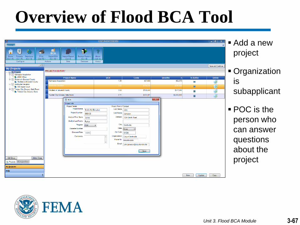
Overview of Flood BCA Tool
Add a new
project
Organization
is
subapplicant
POC is the
person who
can answer
questions
about the
project

Unit 3. Flood BCA Module 3-68
Overview of Flood BCA Tool
Associate the
structure with
the project.
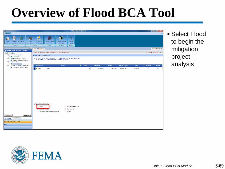
Unit 3. Flood BCA Module 3-69
Overview of Flood BCA Tool
Select Flood
to begin the
mitigation
project
analysis

Unit 3. Flood BCA Module 3-70
Overview of Flood BCA Tool
Select
Mitigation
Project Type:
Acquisition
Elevation
Dry Flood
Proofing/
Flood Barrier
Drainage
Improvement
Other

Unit 3. Flood BCA Module 3-71
Tool asks a series of questions to ensure the user has the appropriate documentation to conduct a full flood analysis
If documentation is deficient, Tool will redirect user to the Damage-Frequency Assessment module
Overview of Flood BCA Tool

Unit 3. Flood BCA Module 3-72
Overview of Flood BCA Tool
Source of Flood Data?
FIS
H&H Study
Both
Project in a SFHA?
Located on FIRM
Source of Flooding?
Riverine
Coastal

Unit 3. Flood BCA Module 3-73
Overview of Flood BCA Tool
Enter the
project useful
life
Select Yes to
detailed SOW
Enter project
Mitigation
Project Cost
Enter Annual
Project
Maintenance
Costs

Unit 3. Flood BCA Module 3-74
Input
information
about flood
data source
using:
FIS
H&H Study
FIRM
Dynamic Help
will guide users
to location of
data
Overview of Flood BCA Tool

Unit 3. Flood BCA Module 3-75
Riverine Data:
FFE and Diagram Description
Flood
Source
Name and
Flood
Profile
Number
Streambed
Elevation
Overview of Flood BCA Tool

Unit 3. Flood BCA Module 3-76
Coastal Data:
FFE and Diagram Description
BFE or 100-
year elevation
including wave
action
Flood Source
Name and
Flood Profile
Number
Stillwater
Elevation
Overview of Flood BCA Tool

Unit 3. Flood BCA Module 3-77
Overview of Flood BCA Tool
Total size of
building
(square feet)
BRV
(dollars
/square foot)
Demolition
damage
threshold

Unit 3. Flood BCA Module 3-78
Overview of Flood BCA Tool
RESIDENTIAL
Riverine/Coastal A
Building Type
Foundation
Type
Basement
Coastal V
Obstruction

Unit 3. Flood BCA Module 3-79
Overview of Flood BCA Tool
NON-RESIDENTIAL
Structure Type
Engineered
Pre-Engineered
Primary Use of
Building
Contents Value
Default changes
based on
primary use of
building
Displacement Cost
One-Time
Displacement Cost

Unit 3. Flood BCA Module 3-80
Overview of Flood BCA Tool
Depth Damage Functions
Default/ Library/ Custom
Displacement Costs
FEMA Standard Value:
$1.44/sf/month
One-time
OR
Loss of Rent (rental property)
Building Contents Value
DDF Table populates after inputs are entered

Unit 3. Flood BCA Module 3-81
Overview of Flood BCA Tool
Select other
benefits by adding
columns
Provide justification
Table is
dynamically
generated based
on user-entered
categories

Unit 3. Flood BCA Module 3-82
Overview of Flood BCA Tool
Expected
Annual
Damages
Report
Provides annual damages based on earlier inputs
No further action
is required after
this screen

Unit 3. Flood BCA Module 3-83
Overview of Flood BCA Tool
Summary of Benefits
provides a report on:
Annual Damages
(Before and After
Mitigation)
Expected Avoided
Damages
Mitigation Benefits
Mitigation Cost
Benefit-Cost Ratio

Unit 3. Flood BCA Module 3-84
Flood BCA Case Study
Refer to the Case Study in the
Student Manual
Complete the Flood BCA module
using the Case Study

Unit 3. Flood BCA Module 3-85
Review of BCA Activity
BCR Value Discussion


