26
Unit 5 Subdivision Regulations Planning and Zoning Training

Unit 5Subdivision Regulations
Planning and Zoning Training

Unit 5 – Subdivision Regulations Page 1
Unit 5 – Subdivision Plats What is a Subdivision Plat?
1. A subdivision plat is not an Auditor’s Plat (or Plat of Irregular Description). Here is a useful definition:
An Auditor’s Plat is suitable for property transfers but not for development purposes. An Auditor’s plat is made for taxation purposes at the request of the County Auditor in accordance with Section 57-02-39 NDCC. A County Auditor’s plat is not platting pursuant to Chapter 40-50 or 11-33.2 NDCC, but rather is made for the convenience of tax officials in describing property on the tax rolls.
2. A subdivision plat has more detail and shows features of the property. Its
purpose is to define the exact size and locations of lots, blocks, streets, easements, etc.
Subdivisions are defined similarly in the NDCC for cities and counties. Cities
Counties
NDCC 40-48-01(2). . . . "Subdivision" means the division of a tract or parcel of land into lots for the purpose, whether immediate or future, of sale or of building development, and any plat or plan which includes the creation of any part of one or more streets, public easements, or other rights of way, whether public or private, for access to or from such lots, and the creation of new or enlarged parks, playgrounds, plazas, or open spaces.
NDCC 11-33.2-01 . . . "subdivision" means the division of a lot, tract, or parcel of land, creating one or more lots, tracts, or parcels for the purpose, whether immediate or future, of sale or of building development, and any plat or plan which includes the creation of any part of one or more streets, public easements, or other rights of way, whether public or private, for access to or from any such lot, tract, or parcel, and the creation of new or enlarged parks, playgrounds, plazas, or open spaces.

Unit 5 – Subdivision Regulations Page 2
Processing a Subdivision Plat The Pre-application Meeting
• Before a plat is submitted, sit down with the developer to discuss it informally. This step can be a requirement of your subdivision regulations.
• It is beneficial to do this beforehand to avoid awkward problems later on. The developer should know what is expected before committing the time and expense of preparing a subdivision plat.
• Determine if the concept being proposed is consistent with your
adopted regulations, policies and plans.
• In determining how the concept fits with the area it is proposed for, other related issues will emerge. Perhaps a zoning change will need to be requested in conjunction with the proposed plat.
• At the Pre-application meeting, you can provide the developer with
information on the fees, schedule, submittal deadlines, a copy of your subdivision regulations, a list of items to be shown on the plat, and what the expectations are. Developers appreciate being informed of what the jurisdiction expects; they don’t like surprises.
The Preliminary Plat and Final Plat
• Two plats will be submitted, a preliminary plat and a final plat. If the final plat is eventually approved, that will be the official plat and the only one that gets recorded or filed with the County Recorder.
• The first submittal is the preliminary plat which shows more features
than the final plat, such as elevation contours, any existing structures, and other existing features of the property.
• The final plat is “cleaner” with no contours, structures, or other
existing features (because those will likely change). The most important elements of the final plat are the property boundary distances and locations, rights-of-way, easements and lot areas.
• The preliminary plat is like a working model. Significant effort may be
required of the developer at the preliminary plat level to prepare a map with necessary detail. Most discussions between staff and the
Meet Early
Developers don’t like surprises, so let them know about your requirements and review procedures up-front. This will lead to a smoother review process with fewer headaches on all sides.

Unit 5 – Subdivision Regulations Page 3
developer will also occur at the preliminary platting stage. Once a preliminary plat is deemed suitable, the final plat should not require a lot of additional scrutiny.
Plat Review
• Your processing schedule for placing a preliminary plat on your planning commission’s agenda should allow enough time to properly review a plat. If you are receiving a high volume of proposed plats, you can adjust the schedule, but it is important that the review period is uniform and consistent with all plats.
• The use of a checklist helps with the staff’s review process. The same checklist can be provided to the developer at the pre-application meeting.
• In addition to a staff review of the checklist items, it’s also a good practice to have a committee to review plats before it is on the Planning Commission agenda.
• The Plat Review Committee should include service providers,
representatives from each of the utilities which will be serving the property. Other Plat Review Committee members can include local government service providers such as representatives from city or county engineering department, street or road department, police or sheriff’s department, emergency services providers, schools, etc. Each of these representatives will have some connection to providing services to the new development. A Plat Review Committee review can often save the developer time and money by all working together, sitting around the same table at the same time to resolve any issues.
• Each member of the plat review committee should receive a full-size
copy of the proposed preliminary plat one week in advance of the plat review meeting so they have an opportunity to review it prior to the meeting. The developer will need to provide as many copies as are necessary to distribute to each committee member.
• Sometimes the preliminary plat is fine as submitted. Other times
revisions may be required. If the review process reveals problems with the plat, let the developer know as soon as you have completed the review. If the preliminary plat requires changes, it can be resubmitted prior to the planning commission meeting. Input from the Plat Review Committee can be forwarded to the Planning Commission.
Your Review, Your Opportunity
- Allow enough review time for the Preliminary Plat.
-Make sure they are consistent with your regulations and plans.
-Make sure all utility and service providers have a chance to review and comment.

Unit 5 – Subdivision Regulations Page 4
• The Planning Commission needs information to base their decision on. Input from the committee will help them do this. Keep notes of comments at Plat Review meetings.
• If the preliminary plat is suitable, the Planning Commission can vote to
schedule the public hearing on the final plat. If not, they can recommend revisions. It is in the developer’s own interest to abide by the wishes of the Planning Commission to obtain approval of the final plat.
• If a proposed plat is totally inappropriate, or if the area for which it is
proposed is inconsistent with the comprehensive plan, the Planning Commission should be made aware of this by staff and reaffirm it at their meeting. The process can still proceed but the developer should know that final plat approval may be difficult to achieve.
Requiring Storm Water Plans & Traffic Studies For large plats containing several lots and blocks, it is advisable to require the developer to submit additional information with the proposed plat. For some smaller, single-lot plats, these supplemental items can be waived.
Storm Water Management Plan
• An important element in platting is determining the storm water runoff that will be generated by a development. The developer’s engineer can prepare the storm water plan and it can be checked by the local jurisdiction’s engineer.
• Vacant, undeveloped agricultural land will soak up rainfall and snow melt but developed land has rooftops, driveways, and roadways that shed water. A heavy rainfall can create problems if significant runoff has not been anticipated. Storm water volumes and directions of flow can be calculated and facilities like culverts or drainage swales can be identified.
• Storm Water Management Plans can be a standard requirement for all
large proposed developments. (As a side note, it is important that all storm water facilities, such as culverts, are installed prior to the subdivision lots being sold and structures being built. If they are not installed in advance, they may never be. Once all the lots are sold,

Unit 5 – Subdivision Regulations Page 5
the developer can walk away. A way to make assure the needed improvements are installed would be to hold off on issuing any building permits unless and until the improvements identified in the Storm Water Management Plan have been properly installed.)
Traffic Study
• When reviewing a proposed plat, consider the traffic it will generate. Each home that’s built will translate to a couple of vehicles and several trips back and forth each day. Where will the traffic access other major roadways? Will there be any safety issues with the added traffic volumes? For any sizable development, it is not unreasonable to require the developer to submit a traffic study in conjunction with the plat.
• A traffic study will establish projections for anticipated traffic and will recommend items like signal lights and turning lanes if they are needed. Because these safety improvements are directly associated with the proposed development, costs for installation should be the developer’s responsibility.
Subdivision Layouts – What to Watch For
• Another important issue is the number of access points for a new development. For the safety of future residents, there should be more than one access to a new neighborhood (for larger developments). If for some reason, one access would become blocked, an alternative route is needed for fire trucks, police, or emergency services.
• Regarding street layouts, the design of a subdivision should allow for the logical extension of streets to adjacent properties. If and when the adjoining land develops, street connections should be available to avoid creation of land-locked parcels, to provide access, and to provide a continuity of a future expanded system of streets and roadways.
• Your local engineering staff should apply minimum standards for roads and streets for items such as width, surfacing requirements, and steepness of grades. Again, building permits can be held until roads and streets are completed to your own engineer’s satisfaction. It’s important that roads are built properly because once the plat is recorded, these become public roadways, to be maintained by your own local road or street department.

Unit 5 – Subdivision Regulations Page 6
• Private streets should be discouraged. There may be a temptation to
allow private streets to ease the public cost and burdens of perpetual maintenance, but private streets are not always in the best interest of the future residents. Neighborhood residents who are responsible for their own streets are unaware of the importance of preventative maintenance. When preventative maintenance is ignored, total street reconstructions are inevitable. These are expensive projects and neighborhood associations seldom have adequate funding resources.
• What about lot sizes? If your ordinance doesn’t already specify lot
sizes, or even if it does, here are a few things to consider for rural lots:
- Existing soil types will determine the area needed for a septic system drain field. Soils with a high clay content will require more area. Sandy soils require less area.
- Sometimes, after several years, a drain field may have to be replaced so it’s a good idea to size lots accordingly and have enough room for a second, future drain field.
• Larger lots are not always better especially in urban settings. Utilities
such as water and sewer lines are expensive to install and expensive to replace. More compact development is more affordable because the cost, usually determined by the linear foot, can be shared by more users.
Ghost Platting
Ghost Platting is a method of splitting large rural lots located in subdivisions close to cities. As a community grows, it can reach a rural large-lot subdivision. Ghost platting allows for easier conversion of rural lots to urban lots.
• If a large-lot rural subdivision which was once on the edge of town is now being swallowed up by surrounding development, it may be reasonable to annex that rural subdivision. Annexation, according to some attorneys, means that the municipality is obligated to provide city water and sanitary sewer systems to the annexed lots. The annexation of a rural subdivision can be very costly for the owners of large lots because the water and sewer line installation costs are based on the linear foot. If a lot is several hundred feet wide, the costs for water and sewer may be very burdensome.
Think long-term, not just 5 years in the future, but 20-30 years.

Unit 5 – Subdivision Regulations Page 7
• Ghost platting allows for cost-sharing when a large-lot rural
development is annexed. Ghost platting will show how large lots will be further subdivided into smaller urban-sized lots. When the time comes, the ghost lots can be sold and utility costs can be shared by more users. To plan ahead for conversion from rural to urban subdivisions on the edge of town, ghost lot lines should be observed when the first house is built and proper setback distances should be implemented. It is possible to combine two or more ghost lots if a larger area is desired for a house.
• Note: When converting ghost lots to actual urban lots, problems can occur with mortgage lenders. If the large rural lot is mortgaged, banks may be skeptical about selling off portions of the property. Lenders should be informed early in the process.
A Note on Urban Sprawl To maximize cost-effectiveness of providing people with public utilities and services, it is advisable for a community to grow outward in an orderly manner. A leapfrog, checkerboard pattern of development does not lend itself to maximum efficiency and can increase local government costs of providing services to those residents. When considering proposed rural developments, obtain input from your local service providers on their ability to serve the location. When city dwellers move out into the country, they will often expect a higher level of services than is available. They need to know that the snow drifts on their road may not be plowed by the time they are ready to go to work in the morning. They need to know that a fire truck or ambulance will not be able to respond as quickly as in town. Sometimes it may not be appropriate to approve a rural residential plat that is too remote. The property tax revenues generated by large-lot rural developments should be compared to the actual costs of public services they require. An acre of corn doesn’t generate much property tax revenue but the level of public services on agricultural land is negligible.
The Subdivision Regulations The Subdivision Regulations section of your code will define the steps of the process, it will establish standards for development, and define how plats are to be prepared and recorded.
Some Important Questions to Ask:
What is the cost of providing services to new developments?
Is new development paying for itself?
How?
Unit 5 – Subdivision Regulations Page 8
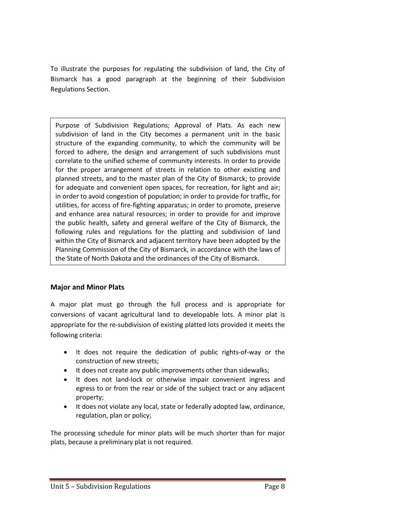
To illustrate the purposes for regulating the subdivision of land, the City of Bismarck has a good paragraph at the beginning of their Subdivision Regulations Section.
Major and Minor Plats
A major plat must go through the full process and is appropriate for conversions of vacant agricultural land to developable lots. A minor plat is appropriate for the re-subdivision of existing platted lots provided it meets the following criteria:
• It does not require the dedication of public rights-of-way or the construction of new streets;
• It does not create any public improvements other than sidewalks; • It does not land-lock or otherwise impair convenient ingress and
egress to or from the rear or side of the subject tract or any adjacent property;
• It does not violate any local, state or federally adopted law, ordinance, regulation, plan or policy;
The processing schedule for minor plats will be much shorter than for major plats, because a preliminary plat is not required.
Purpose of Subdivision Regulations; Approval of Plats. As each new subdivision of land in the City becomes a permanent unit in the basic structure of the expanding community, to which the community will be forced to adhere, the design and arrangement of such subdivisions must correlate to the unified scheme of community interests. In order to provide for the proper arrangement of streets in relation to other existing and planned streets, and to the master plan of the City of Bismarck; to provide for adequate and convenient open spaces, for recreation, for light and air; in order to avoid congestion of population; in order to provide for traffic, for utilities, for access of fire-fighting apparatus; in order to promote, preserve and enhance area natural resources; in order to provide for and improve the public health, safety and general welfare of the City of Bismarck, the following rules and regulations for the platting and subdivision of land within the City of Bismarck and adjacent territory have been adopted by the Planning Commission of the City of Bismarck, in accordance with the laws of the State of North Dakota and the ordinances of the City of Bismarck.

Unit 5 – Subdivision Regulations Page 9
Plat Certifications and Dedications It is important that the application form requesting subdivision plat approval includes all property owners’ signatures and contact information. The application form can also include the name of the developer and in many cases, but not all, the developer will also own the property. The actual owner(s) of the property must also sign the final plat. A title insurance policy or an attorney’s opinion of title is required for plat approval. The title insurance or attorney’s opinion should be current. If they are not recent documents, a land ownership transfer may have occurred since they were drafted.
Submittal Requirements The contents of preliminary and final plats are defined in the Subdivision Regulations. These mapping features and elements can be documented on a list to be provided to developers. Lists are valuable not only for developers, but for staff to review a plat. The NDCC provides lists of required elements for plats. For counties, the basic elements are defined below:
40-50.1-03. Instruments of dedication - Certifying and recording plat. The plat must contain a written instrument of dedication, which is signed and acknowledged by the owner of the land. When there is divided ownership, there must be indicated under each signature the lot or parts of lots in which each party claims an interest. All signatures on the plat must be written with black ink, not ballpoint ink. The instrument of dedication must contain a full and accurate description of the land platted. The registered land surveyor shall certify on the plat that the plat is a correct representation of the survey, that all distances are correct and monuments are placed in the ground as shown, and that the outside boundary lines are correctly designated on the plat. The dedication and certificate must be sworn to before an officer authorized to administer an oath. The plat must be presented for approval to the governing body affected by the plat, together with a copy of a title insurance policy or an attorney's opinion of title, running to the benefit of the governing body affected by the plat, stating the name of the owner of record.

Unit 5 – Subdivision Regulations Page 10
11-33.2-04. Preparation of subdivision resolution - Contents. The board of county commissioners of any county desiring to avail itself of the powers conferred by sections 11-33.2-01 through 11-33.2-11 and sections 11-33.2-13 through 11-33.2-15 shall direct the county planning commission, as established pursuant to sections 11-33-04 and 11-33-05, to prepare a proposed resolution regulating the subdivision of land. The county planning commission shall prepare the proposed resolution to be submitted to the board of county commissioners and shall file it in the office of the county auditor. The proposed subdivision resolution may include:
1. Provisions for the submittal and processing of plats, and specifications for such plats, including provisions for preliminary and final approval and for processing of final approval by stages or sections of development.
2. Provisions for ensuring that:
a. The location, layout, or arrangement of a proposed subdivision shall conform to the comprehensive plan of the county.
b. Streets in and bordering a subdivision shall be coordinated, and be of such width and grade and in such locations as deemed necessary to accommodate prospective traffic, and facilitate fire protection.
c. Adequate easements or rights of way shall be provided for drainage and utilities.
d. Reservations if any by the developer of any area designed for use as public grounds shall be of suitable size and location for the designated use.
e. Land which is subject to extraordinary hazards, including flooding and subsidence, either shall be made safe for the purpose for which such land is proposed to be used, or shall be set aside for uses which shall not endanger life or property or further aggravate or increase the existing hazard.
3. Provisions governing the standards that public improvements shall meet, including streets, walkways, curbs, gutters, streetlights, fire hydrants, and water and sewage facilities. As a condition of final approval of plats, the board of county commissioners may require that the subdivider make and install such public improvements at the subdivider's expense and that the subdivider execute a surety bond or other security to ensure that the subdivider will so make those improvements within such time as the board of county commissioners shall set.
4. Provisions for release of a surety bond or other security upon completion of public improvements required to be made by the subdivider.
5. Provisions for encouraging and promoting flexibility, economy, and ingenuity in the location, layout, and design of subdivisions, including provisions authorizing the board of county commissioners to attach conditions to plat approvals requiring practices which are in accordance with modern and evolving principles of subdivision planning and development, as determined by the board of county commissioners.

Unit 5 – Subdivision Regulations Page 11
Similarly, for cities, the NDCC provides a listing of basic elements to be shown on subdivision plats (see below):
40-50.1-01. Laying out townsites, additions, and subdivisions - Survey and plat required - Contents of plat. Any person desiring to lay out a townsite, an addition to a townsite, or a subdivision of land shall cause the land to be surveyed and a plat made of the land. The written plat must comply with the following:
1. The plat must describe particularly and set forth all the streets, alleys, and public grounds, and all outlots or fractional lots within or adjoining the townsite or jurisdiction, together with the names, widths, courses, boundaries, and extent of all such streets, alleys, and public grounds, and giving the dimensions of all lots, streets, alleys, and public grounds.
2. All lots and blocks, however designated, must be numbered in progressive numbers and their precise length, width, and area be stated on the map or plat. The streets, alleys, or roads which divide or border the lots must be shown on the map or plat.
3. The plat must indicate that all outside boundary monuments have been set and indicate those interior monuments that have been set. There must be shown on the plat all survey and mathematical information, including bearings and distances, and data necessary to locate all monuments and to locate and retrace all interior and exterior boundary lines appearing on the plat. All interior lot lines and exterior boundary lines of the plat must be correctly designated on the plat and show bearings on all straight lines, or angles at all angle points, and central angle, radius, and arc length for all curves. All distances must be shown between all monuments as measured to the hundredth of a foot [0.3048 centimeter]. All lot distances must be shown on the plat to the nearest hundredth of a foot [0.3048 centimeter] and all curved lines within the plat must show central angles, radii, and arc distances. A north arrow and the scale of the plat must be shown on the plat. The scale must be of a dimension that the plat may be easily interpreted. If a curved line constitutes the line of more than one lot in any block of a plat, the central angle for that part of each lot on the curved line must be shown.
4. Ditto marks may not be used on the plat for any purposes.
5. If a river, stream, creek, or lake constitutes a boundary line within or of the plat, a survey line must be shown with bearings or angles and distances between all angle points and their relation to a waterline, and all distances measured on the survey line between lot lines must be shown, and the survey line shown as a dashed line.
6. The unadjusted outside boundary survey and the plat survey data must close by latitude and departure with an error that does not exceed one part in ten thousand parts.
7. All rivers, streams, creeks, lakes, and all public highways, streets, and alleys of record must be correctly located and plainly shown and designated on the plat.

Unit 5 – Subdivision Regulations Page 12
The elements of the NDCC listed above can be translated into subdivision regulations requirements, as many jurisdictions have already done. Materials provided to the developer at the initial pre-application meeting can also include these lists. When a plat is submitted, the same lists can be used again to determine if the proposed plat is complete. Some example lists are provided at the end of this section.
Conclusion Once a subdivision plat is approved, the underground utilities are installed and the streets are built, the development pattern is set. Another puzzle piece has been put in place. As growth occurs, adjoining developments will be tying into and extending the streets and utilities. An adopted master plan which shows the big-picture expectations for community growth will help to integrate these larger, community-wide systems. Supplemental plans for a future roadway/street network or a trails network can apply to each new subdivision, as well as requirements for parks and recreational facilities.
40-50.1-01. (continued) 8. The names and adjacent boundary lines of any adjoining platted
lands must be dotted on the plat.
9. The scale must be shown graphically and the basis of bearings must be shown. The plat must be dated as to the completion of the survey and preparation of the plat.
10. The purpose of any easement shown on the plat must be clearly stated. Building setbacks may not be shown on the plat.
11. Any plat which includes lands abutting upon any lake, river, or stream must show a contour line denoting the present shoreline, water elevation, and the date of survey. If any part of a plat lies within the one hundred year floodplain of a lake, river, or stream as designated by the state engineer or a federal agency, the mean sea level elevation of that one hundred year flood must be denoted on the plat by numerals. Topographic contours at a two-foot [60.96-centimeter] contour interval referenced to mean sea level must be shown for the portion of the plat lying within the floodplain. All elevations must be referenced to a durable benchmark described on the plat with its location and elevation to the nearest hundredth of a foot [0.3048 centimeter], which must be given in mean sea level datum.

1
CITY/ETA SUBDIVISION PLAT SUBMITTAL CHECKLIST
The following is a summary of the information required on all subdivision plats submitted for review and approval, basedon the requirements of Section 14-09-07 of the City Code of Ordinances (Specifications for Plats). The applicant checklistcolumn for the appropriate subdivision plat type (preliminary or final/minor) must be completed by the applicant and thisform must be submitted in conjunction with the unified development application. If required items are not included on aplat submitted for approval, the application will be deemed incomplete.
01/08
I. PRELIMINARY SUBDIVISION PLATS Applicant Staff
Checklist Checklist
a. Proposed name of the subdivision plat (if in City use “addition”, if in ETA use “subdivision”).
b. Location of subdivision plat by section, township and range (to the quarter section).
c. Names and addresses of property owner(s) and registered land surveyor who prepared the plat.
d. Scale of 1” = 100' or less, shown graphically (A different scale may be used only if it has previously been approved by the Director of Planning & Development).
e. Date.
f. North point indication (arrow or compass rose).
g. Boundary line of proposed subdivision plat indicated by a solid heavy line.
h. Total acreage within the subdivision plat.
i. A location map inset showing the boundary of the proposed subdivision plat and covering an area within a one mile radius of the subdivision plat.
j. Existing & proposed access points along public right-of-way within or adjacent to the subdivision plat. For subdivision plats within the ETA, all access points within ¼ mile of the subdivision plat shall be shown.
k. Name, location, and width of all existing or previously platted streets, including the type and width of surfacing, within or adjacent to the subdivision plat.
l. Name, dimensions and location of any railroad right-of-way within or adjacent to the subdivision plat.
m. Name, dimensions and location of any utility easements within or adjacent to the subdivision plat.
n. Name, dimensions and location of any parks, public land or multi-use trails or crosswalks within or adjacent to the subdivision plat.
o. Name, dimensions and location of any permanent buildings or structures within or adjacent to the subdivision plat.
Existing
General Information
Print Form

2
Applicant Staff Existing continued Checklist Checklist
p. Location of any corporate boundary if within or adjacent to the subdivision plat.
q. Location and identification of any sections lines within or adjacent to the subdivision plat.
r. Existing water mains, storm sewers, sanitary sewers, culverts, bridges, poles, pipelines and other utility structures within or adjacent to the tract, indicating pipe sizes, grades, and exact locations.
s. Existing zoning of proposed subdivision plat and adjacent tracts of subdivided and un-subdivided land.
t. Boundary lines of tracts of subdivided and un-subdivided land within or adjacent to the proposed subdivision plat (including any lots being replatted). Owners names are not needed for adjacent tracts within the corporate limits but must be shown for any adjacent tracts within the ETA.
u. Topographic contours with a minimum contour interval of 2 feet, with indication of datum used (NGVD29 or NAVD88 with NAVD88 required for areas with floodplain information in that datum).
v. 100-year floodplain and floodway elevations if any portion of the subdivision plat is within the floodplain, with indication of datum used (NAVD88 required for areas with current information in that datum).
Proposed
w. Layout, numbers and dimensions of lots and blocks.
x. Layout of proposed streets, alleys, crosswalks and easements, showing all widths and proposed street names.
y. Location and dimensions of proposed utility easements, including easements for storm water management facilities and proposed locations of culverts and retention/detention areas, if available.
z. Location and dimensions of non-access lines.
aa. Identification of parcels of land intended to be dedicated or reserved for public uses, or set aside for use of property owners within the subdivision plat.
bb. Fencing note, if required, in accordance with Section 14-09-06 for property adjacent to I-94 or any open drainage facility.
cc. Airport noise contours within or adjacent to the subdivision plat as established by the latest available data.
dd. Location of streams, water courses and marshy or swampy areas within or adjacent to the subdivision plat, including federally designated wetlands (must be labeled).

3
II. FINAL & MINOR SUBDIVISION PLATSa. Name of the subdivision plat (if in City use “addition”, if in ETA use “subdivision”).
j. Legal description of property being platted, including any section line right-of-way not previously deeded for subdivision plats within the ETA.
k. Accurate locations of all monuments. One monument shall be placed at each corner and at each change of direction in theboundary line of the subdivision plat. In addition, one monument shall be noted/ placed at each block corner; at eachpoint of deflection in the interior lot lines; and at the point of curvature and point of tangency of each curve in a street line on both sides of the street. Whether monuments are to be noted or placed prior to recording the plat is based on the location of the subdivision plat.
l. True angles and distances to the nearest official monuments. For subdivision plats adjacent to or within the current corporate limits, a tie to at least one official monument is required. For subdivision plats within the ETA, ties to two official monuments are required. For purposes of this requirement, an official monument is an official government monument, such as a section corner or quarter section corner.
m. Ties to a minimum of two accepted State Plane Coordinate monuments based on NAD 83 horizontal datum (adjusted 86), units of measurement international feet, ND south zone 3302.
n. Elevations referenced to a durable benchmark described on the plat within its location to the nearest hundredth of a foot, with indication of datum used (NAVD88 required for areas with current floodplain information in that datum).
o. Exact location, width and name of all rights-of-way within and adjoining the subdivision plat, and the exact location of all alleys and multi-use trails within the subdivision plat.
p. Accurate outlines and legal descriptions of any areas (not including streets, alleys or public utility easements) to be dedicated or reserved for public use, with the purposes indicated; and of any areas to be reserved by deed covenant for common use of all property owners within the subdivision plat.
s. Square footage or acreage of land within the subdivision plat, each individual lot, each sublot created by ghost platting, and the total area in streets. If the subdivision plat crosses a quarter-section line, the acreage within each quarter section must also be noted.
b. Location of subdivision plat by section, township and range (to the quarter section).
d. Scale of 1” = 100' or less, shown graphically.
c. Names and addresses of property owner(s) and registered land surveyor.
f. North point indication (arrow or compass rose).
e. Date.
g. Basis of bearings, as derived from State Plane Coordinates.
h. Indication of both vertical datum and horizontal datum used for the plat.
i. Boundary line of subdivision plat based on an accurate traverse, with angular and linear dimensions.
q. All easements for rights-of-way provided for public services and public utilities.
r. All lot numbers and block numbers and lot lines, with accurate dimensions in feet and hundredths.
t. Radii, deltas and lengths of all curves based on arc definitions.
u. Location and dimensions of non-access lines and access points within a continuous non-access line.

4
Final Plats continued
v. 100-year floodplain and floodway elevations and topographic contours with a minimum contour interval of 2 feet for any portion of the subdivision plat within a designated floodplain, with indication of datum used (NAVD88 required for areas with current floodplain information in that datum).
w. For any waterways or bodies of water within or adjacent to the subdivision plat, the present shoreline locations (relative to the meander line).
y. For subdivision plats adjacent to theMissouri River, the 33,000 cfs flow elevation must be shown, which is the ordinary high water mark defined in the zoning ordinance for the purpose of measuring setbacks.
z. Certification by the registered surveyor that the subdivision plat represents a survey made by him/her, or under the surveyor's direct supervision, and that the monuments shown thereon are accurate, all required monuments have been set, and that all dimensional and geodetic details are correct.
aa. Notarized certification by all owner(s) of the land of adoption of the subdivision plat and dedication of sewers, water distribution lines, streets, public areas and other improvements. If there are multiple owners, the specific lot(s) owned by each must be specified.
hh. Minimum sheet size of 30” x 36” required. If more than one sheet is required, an index sheet showing the entire subdivision plat on one sheet must submitted, all sheets must be numbered, of the same size, and include matchlines. A border of ½ inch shall be proved on the top, bottom, and right sides of the subdivision plat and a border of 2 inches shall be provided on the left side.
cc. Proper form for acceptance of the subdivision plat and amendment of the Master Streetplan by the Board of City Commissioners. For subdivision plats within the ETA, proper form for acceptance of the right-of-way by the Burleigh County Board of Commissioners is also required.
x. Water elevations must be shown and dated (meander line).
bb. Proper form for approval of the Planning & Zoning Commission.
dd. Proper form for approval by the City Engineer.
ee. Fencing note, if required for fencing along Interstate 94 or any open drainage facility.
ff. All restrictive airport noise, clear zone and approach zone elevations within or adjacent to the subdivision plat.
gg. All easements for stormwater management facilities shall be shown and dedicated.

1
COUNTY PLAT SUBMITTAL CHECKLISTSThe following information is required on all plats submitted for review and approval by Burleigh County. The applicantchecklist column for the appropriate plat type (preliminary or final) must be completed by the applicant and this form mustbe submitted in conjunction with the unified development application. If required items are not included on a platsubmitted for approval, the application will be deemed incomplete.
01/07
COUNTY SUBMISSION CHECKLIST General Information Applicant Staff
Checklist Checklist
1. Proposed name of subdivision (use “subdivision” rather than “addition”)
The following checklist must be completed and submitted with the application form.
2. Location of subdivision by section, township and range (to nearest quarter section)
3. Name and address of registered land surveyor
4. Name and address of property owner
5. Scale of 1” = 100' or less, shown graphically (A different scale may be used only if it has previously been approved by the Director of Planning & Development)
6. Date
7. North point indication (arrow or compass rose)
8. Boundary line of proposed subdivision indicated by a solid heavy line
9. Total acreage within the subdivision and each individual lot
10. A location map inset showing the boundary of the proposed subdivision and covering an area within a one mile radius of the subdivision
EXISTING11. Existing access points along public right-of-way within or adjacent to the subdivision. All such adjacent access points within ¼ mile of the subdivision shall be shown or noted
12. Name, location, and width of all existing or previously platted streets, including the type and width of surfacing, within or adjacent to the subdivision
13. Name, dimensions and location of any railroad right-of-way within or adjacent to the subdivision
14. Name, dimensions and location of any utility easements within or adjacent to the subdivision
15. Name, dimensions and location of any parks or public land within or adjacent to the subdivision
16. Name, dimensions and location of any permanent buildings or structures within or adjacent to the subdivision
Print Form

2
Applicant Staff EXISTING continued Checklist Checklist
17. Location of any corporate boundaries within or adjacent to the subdivision
18. Location of section lines within or adjacent to the subdivision
19. Existing water mains, storm sewers, sanitary sewers, culverts, bridges, poles, pipelines and other utility structures within or adjacent to the tract, indicating pipe sizes, grades, and exact locations
20. Existing zoning of proposed subdivision and all adjacent tracts
21. Boundary lines of adjacent tracts of subdivided and un-subdivided land, showing owners names
22. Location of streams, water courses and marshy or swampy areas within or adjacent to the subdivision, including federally designated wetlands (must be labeled)
23. Topographic contours with a minimum contour interval of 5 feet, with indication of datum used (NGVD29 or NAVD88, with NAVD88 preferred for all areas and required for areas with current floodplain information in that datum)
24. 100-year floodplain and floodway elevations if any portion of the subdivision is within the floodplain, with indication of datum used (NAVD88 required for areas with current floodplain information in that datum )
25. Boundaries of any existing underlying lot(s) being replatted, if any
PROPOSED
26. Layout, numbers and dimensions of lots
27. Layout of proposed streets, alleys, crosswalks and easements, showing all widths and proposed street names
28. Location and dimensions of non-access lines
29. Identification of parcels of land intended to be dedicated or reserved for public uses, or set aside for use of property owners within the subdivision
FINAL PLATS
1. Minimum sheet size of 30” x 36”. If more than one sheet is required, an index sheet showing the entire subdivision on one sheet must submitted, all sheets must be numbered, of the same size, and include matchlines. A border of ½ inch shall be provided on the top, bottom, and right sides of the plat and a border of 2 inches shall be provided on the left side
2. Name of the subdivision (use “subdivision” rather than “addition”)
3. Location of subdivision by section, township and range (to nearest quarter section)
4. Name and address of registered land surveyor
5. Name and address of property owner
6. Scale of 1” = 100' or less, shown graphically
7. Basis of bearings
8. Date
9. North point indication (arrow or compass rose)

3
FINAL PLATS continued
10. Boundary line of subdivision based on an accurate traverse, with angular and linear dimensions
11. Legal description of property being platted, including any section line right-of-way not previously deeded for roadway purpose
12. Accurate locations of all monuments, which shall be one (1) inch diameter iron pipes eighteen (18) inches in length. One monument shall be placed at each corner and at each change of direction in the boundary line of the subdivision; one monument shall be placed at each block corner; and one monument shall be placed at the point of curvature and point of tangency of each curve in a street line on both sides of the street
13. True angles and distances to the nearest established street lines or official monuments, not less than 2 need to be accurately described on the plat. For purposes of this requirement, an official monument is an official government monument, such as a section corner or quarter section corner
14. Ties to within 12 inches of a minimum of two accepted State Plane Coordinate monuments based on NAD 83 ND Zone 3302
15. Exact location, width and name of all streets within and adjoining the subdivision and exact location of all alleys and crosswalks within the subdivision
16. Accurate outlines and legal descriptions of any areas (not including streets, alleys or public utility easements) to be dedicated or reserved for public use, with the purposes indicated; and of any area to be reserved for common use of all property owners within the subdivision
17. All easements for rights-of-way provided for public services and utilities
18. All lot numbers and lot lines, with accurate dimensions in feet and hundredths
19. Square footage or acreage of land within the subdivision, each individual lot and the total area in streets. If the subdivision crosses a quarter-section line, the acreage within each quarter section must also be noted
20. City, township, county or section lines accurately tied to the boundary lines of the subdivision by distance and angles;
21. Radii, internal angles, points of curvature, tangent bearings and lengths of all arc
22. Location and dimensions of non-access lines
23. 100-year floodplain and floodway elevations and topographic contours with a minimum contour interval of five (5) feet for any portion of the subdivision within a designated floodplain, with indication of datum used (NAVD88 required for areas with current floodplain information in that datum )
24. Present shoreline locations and water elevations shown and dated for any waterways or bodies of water within the subdivision (meander line)
25. For subdivisions adjacent to theMissouri River, the 33,000 cfs flow elevation must be shown
26. Certification by a registered surveyor that the plat represents a survey made by him/her, that monuments shown thereon exist as located and that all dimensional and geodetic details are correct
27. Notarized certification by all owners of the land of adoption of the plat and dedication of sewers, water distribution lines, streets, public areas and other improvements
28. Proper form for approval of the Planning Commission
29. Proper form for acceptance of the plat and amendment of the master plan by the Board of County Commissioners
30. Proper form for approval by the CountyEngineer


∆
∆
∆
∆
∆
∆
∆
∆


