United Republic of Tanzania TANZANIA METEOROLOGICAL AGENCY MONITORING OF TROPICAL CYCLONES IN TANZANIA NOVEMBER 2019 St. Denis Reunion Leonia Celestin Msafiri ([email protected]) (Principal Meteorologist)
Transcript
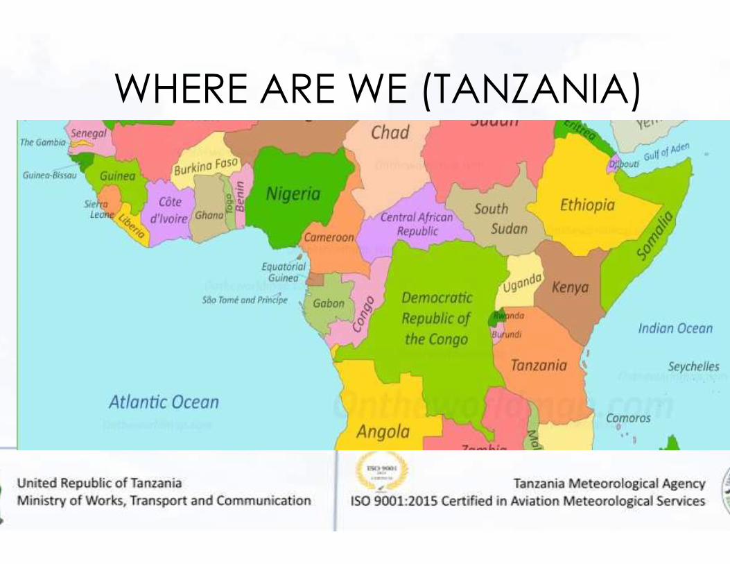
United Republic of TanzaniaTANZANIA METEOROLOGICAL AGENCYMONITORING OF TROPICAL CYCLONES
• Average of 500mm of precipitation during rain season
• Wet season from November to April, other time comprises with dry season.
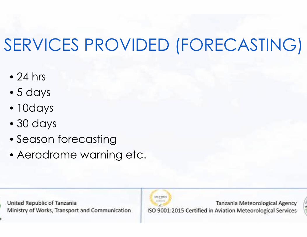
SERVICES PROVIDED (FORECASTING)
• 24 hrs
• 5 days
• 10days
• 30 days
• Season forecasting
• Aerodrome warning etc.
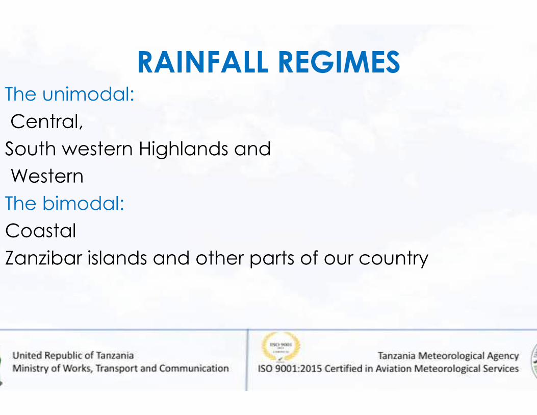
RAINFALL REGIMESThe unimodal:
Central,
South western Highlands and
Western
The bimodal:
Coastal
Zanzibar islands and other parts of our country
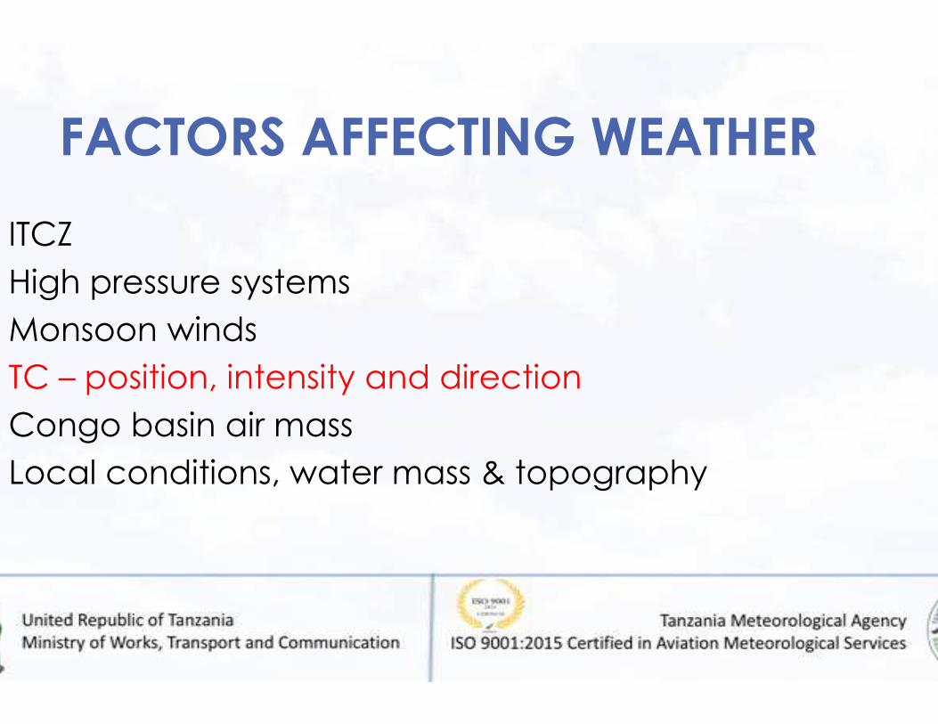
ITCZ
High pressure systems
Monsoon winds
TC – position, intensity and direction
Congo basin air mass
Local conditions, water mass & topography
FACTORS AFFECTING WEATHER
CRITERIA FOR AERODROME WARNINGObtain briefing of current weather situation of development of CB, Tropical cyclone etc. from Observer from Observer or forecaster on duty.
Study actual weather information from Satellite images and Radar data.
Study different NWP models and general weather forecast
If step 1 to 3 is significant issue and disseminate Aerodrome warning accordingly
Continuous monitoring the weather
Cancelling the Aerodrome warning
AERODROME WARNING
Tropical cyclones
Thunderstorms
Hail
Sandstorm
Dust storm
Strong wind surface
Volcanic Ash
Rising sand or dust etc
• Sometimes the winds that are associated with Tropical Cyclones bring heavy to moderate rainfall that favored agriculture sector by provision of optimum rainfall and enough pasture and water for our animals an wild life.
• These rainfall has an impact on fishing industry.
POSITIVE IMPACTS OF TROPICAL CYCLONES
Due to heavy rainfall sometimes can causes:
Floods affect settlements, infrastructure like roads,railways, bridges, power, farming systems.
Spread of waterborne diseases like malaria.
Fishermen and students are limited on their dailyactivities.
Communication systems.
NEGATIVE IMPACTS OF TROPICAL CYCLONES
TC bulletin from RSMC – La Reunion
Satellite imagery
Radar
Synergie
MONITORING OF TROPICAL CYCLONES
TROPICAL CYCLONE- KENNETH
MONITORING OF TROPICAL CYCLONE-KENNETH
21st of April 2019:
The deep cloud band rotating around the location near north east of Madagascar.
Located west of 60 degrees East and near 9 degrees South
NWP Models estimated the central pressure at around 1006hPa.
MONITORING CONT.
22nd of April 2019:
We received a bulletin from Meteo-France La Reunion (RSMS MFR) mentioning it to be located near 9.10S/51.50E
Central pressure of 1006hPa
Maximum wind 25kt.
MONITORING CONT
23rd of April 2019:
The system was given a name KENNETH
According to RSMC MFR it was located at around 10.3S/49.6E.
The central pressure was 998hPa
Maximum wind was 35kt
It was estimated to move towards the west at 8kt
MONITORING CONT
24th of April 2019
Position at 09z: 11s/45.2E
Movement: west at 10kt
Maximum wind : 65kt
Central Pressure: 982hPa
MONITORING CONT
25TH of April 2019
Position at 09z:11.9S/41.3 E
Movement: west-south at 10kt
Maximum wind: 115kt
Central Pressure: 934hPa
MONITORING CONT
26th of April 2019
Position: 12.4S/39.6E (Overland depression over Mozambique)
Movement: west at 5kt
Maximum wind: 35kt
Central Pressure: 995hpa
MONITORING CONT
The first information to National Disaster Management Office was issued on the 23rd of April 2019.
The 1st information issued to Public was on the 22nd of April 2019.
TMA system situation information issued on 21st of April 2019
The NDMO ground situation information issued on 24th of April 2019
Providing impact based forecast
Videos and sound clips which were uploaded on TMA websites and shared on social media
TMA website
Disaster management Department –PMO
TV, Radio, Newspapers
Social Media (WhatsApp, YouTube, Facebook, tweeter and Instagram)
DISSEMINATION OF WARNING
INFORMATION/WARNING ISSUED TO MEDIA
22nd April 2019 - information presentation by DG
23rd April 2019 - information press presentation
24th April 2019 - Warning press release (press conference and document) by DG
25th April 2019 - Warning update press document by DG
26th April 2019 – Warning cancellation press release (press conference and document)
REACTION OF MEDIA
Many of them visited and /or called the Authority to get more clarification
False/uninformed information was also created by unknown people and circulated within the social media
• 23rd April information on like hood of formation of TC were issued
• 24th April 2019 warning on severe Tropical storm development was issued.
• 25th April 2019 update of warning and prevailing development status of the storm (Tropical Cyclone) were issued.
• 26th April 2019 mid-day warning cancellation issued.
• 26th April 2019 the NDMO chief Executive Officer together with TMA’s Director General conducted press conference to the public through media on information of the ground situation and cancellation of warning.
INFORMATION/WARNING ISSUED TO NDMO
PRODUCTS ISSUED BY TMA
Press documents
Video clips
Live broadcasting through TV and radio stations.
TMA’s zonal office at Mtwara were sharing 30 min to hourly Meteorological data, the ground photo and other information
• Tropical cyclones named KENNETH is one of the Tropical Cyclone which came near our Country.
• The lowest central Pressure was 934hPa
• It was categorized as INTENSE TROPICAL CYCLONE near 11.9S/41.3E
• Near 10.3S/49.6E it was categorized as SEVERE TROPICAL STORM.
• KENNETH reached the maximum wind speed of 115kt, in Mtwara, the highest wind speed was 60kt.
• The highest rainfall amount recorded at Mtwara weather station was 10mm on 25th April 2019