United States Department of the Interior BUREAU OF LAND MANAGEMENT California Desert District 22835 Calle San Juan De Los Lagos Moreno Valley, CA 92553‐9046 www.ca.blm.gov COMMENTS: Draft Final WQC, Eagle Mountain Pumped Storage Project, FERC Project No. 13123 April 10, 2013 In Reply Refer to: CACA50946 - P LLCAD01500 April 10, 2013 Mr. Oscar Biondi State Water Resources Control Board Division of Water Rights P.O. Box 2000 Sacramento, CA 95812-2000 [email protected]RE: COMMENTS ON DRAFT FINAL WATER QUALITY CERTIFICATION FOR THE EAGLE MOUNTAIN PUMPED STORAGE PROJECT, FEDERAL ENERGY REGULATORY COMMISSION PROJECT NO. 13123 Dear Mr. Biondi, As the State Water Resources Control Board (Board) is aware, the BLM is initiating the environmental review process for a right-of-way request in response to an application filed by Eagle Crest Energy Company. The BLM has already approved, or is in the process of evaluating, a number of renewable energy projects in the Chuckwalla Valley that identifies demands for groundwater in this basin. Given this increased demand, and the potential uncertainty associated with existing information and modeling efforts, the BLM in concert with a number of research organizations, including the U.S. Geological Survey, Lawrence Berkeley National Laboratory (in conjunction with Pennsylvania State University), Argonne National Laboratory, and the National Resource Conservation Service, has initiated a number of groundwater investigations that are beginning to produce reliable information that may influence our collective current understanding of the groundwater system. BLM appreciates the opportunity to comment on the Draft Final Water Quality Certification for the Eagle Mountain Pumped Storage Project (Eagle Mountain Project) and encourages the Board to seriously consider the suggested revisions to Condition 5. Our recommendations build upon the Board’s use of adaptive management measures that call for project operation changes to address findings from new information and reduce uncertainty.
Transcript
United States Department of the Interior
BUREAU OF LAND MANAGEMENT
California Desert District
22835 Calle San Juan De Los Lagos
Moreno Valley, CA 92553‐9046
www.ca.blm.gov
COMMENTS: Draft Final WQC, Eagle Mountain Pumped Storage Project, FERC Project No. 13123 April 10, 2013
In Reply Refer to:
CACA50946 - P LLCAD01500 April 10, 2013 Mr. Oscar Biondi State Water Resources Control Board Division of Water Rights P.O. Box 2000 Sacramento, CA 95812-2000 [email protected] RE: COMMENTS ON DRAFT FINAL WATER QUALITY CERTIFICATION FOR THE EAGLE MOUNTAIN PUMPED STORAGE PROJECT, FEDERAL ENERGY REGULATORY COMMISSION PROJECT NO. 13123 Dear Mr. Biondi, As the State Water Resources Control Board (Board) is aware, the BLM is initiating the environmental review process for a right-of-way request in response to an application filed by Eagle Crest Energy Company. The BLM has already approved, or is in the process of evaluating, a number of renewable energy projects in the Chuckwalla Valley that identifies demands for groundwater in this basin. Given this increased demand, and the potential uncertainty associated with existing information and modeling efforts, the BLM in concert with a number of research organizations, including the U.S. Geological Survey, Lawrence Berkeley National Laboratory (in conjunction with Pennsylvania State University), Argonne National Laboratory, and the National Resource Conservation Service, has initiated a number of groundwater investigations that are beginning to produce reliable information that may influence our collective current understanding of the groundwater system. BLM appreciates the opportunity to comment on the Draft Final Water Quality Certification for the Eagle Mountain Pumped Storage Project (Eagle Mountain Project) and encourages the Board to seriously consider the suggested revisions to Condition 5. Our recommendations build upon the Board’s use of adaptive management measures that call for project operation changes to address findings from new information and reduce uncertainty.
COMMENTS: Draft Final WQC, Eagle Mountain Pumped Storage Project, FERC Project No. 13123 April 10, 2013
Page 2
INTRODUCTION New information, along with new analysis, has been and is being developed to better understand the issues of water supply in the Chuckwalla Valley Groundwater Basin (Chuckwalla Basin). At present, the Bureau of Land Management (BLM) has identified considerable uncertainty regarding groundwater recharge estimates and potential impacts to the Colorado River from proposed groundwater pumping in support of the Eagle Mountain Pumped Storage Project (Eagle Mountain Project). Given new information, this uncertainty is compounded by reliance on preliminary analysis such as is provided in the Eagle Mountain Pumped Storage Project – Revised Groundwater Supply Pumping Effects technical memorandum produced by GEI Consultants, Inc. in 2009. There is a potential for overdraft conditions to occur within the Chuckwalla Basin. There is also the potential for impacts to occur to Colorado River flows. The BLM and the approved or proposed projects within the BLM-designated Riverside East Solar Energy Zone could suffer serious harm from overproduction of groundwater in this area. The BLM suggests that the State Water Resources Control Board (Water Board) consider re-evaluation of these groundwater issues and make changes to Condition 5. GROUNDWATER SUPPLY that would diminish that potential for harm and help remove some of the existing uncertainty. BLM Investigations A focal point for solar energy expansion in southern California is the Riverside East SEZ, proposed in the recently published Solar Programmatic Final EIS (BLM/DOE, 2012). This document categorizes Federal lands near the Interstate 10 corridor in southern California as suitable for development of renewable energy. The SEZ consists of lands extending from near Desert Center, CA to near Blythe, CA. Most of these lands are within the Chuckwalla Basin, with the balance being located in the Palo Verde Mesa Groundwater Basin, adjacent to the Colorado River and its floodplain in this area, called the Palo Verde Valley. The BLM is currently developing programs to better understand the impacts that projects located within the Riverside East SEZ may have on local groundwater resources. One of these efforts is a pilot monitoring project, under the Solar Programmatic EIS, using landscape scale indicators of resource condition. Argonne National Laboratory is part of this effort and has conducted preliminary modeling to better understand water resources in the Chuckwalla Basin. This model corroborates the idea that the basin in currently in groundwater overdraft condition, while projections of groundwater consumption from solar development are as much as about 15,000 afy. Another related program is focused on an assessment of renewable energy project impacts on groundwater in the Chuckwalla Basin. This is a joint effort involving input and activities from Lawrence Berkeley National Laboratory (Lawrence Berkeley) along with its partner
COMMENTS: Draft Final WQC, Eagle Mountain Pumped Storage Project, FERC Project No. 13123 April 10, 2013
Page 3
Pennsylvania State University (Penn State), the U.S. Geological Survey (USGS), and the National Resource Conservation Service (NRCS). The objectives of this program include developing baseline water level data, better quantifying the perennial yield of the basin, identifying water level trends, and documenting any hydrologic impacts that development may have. The principal tasks are to 1) compile currently available information and oversee a groundwater monitoring network, 2) develop an easily accessible database as a repository for all existing and future information collected, 3) develop a robust numerical groundwater flow and water balance model of the basin, and 4) meld these components into a land management tool that will readily inform Federal decision makers in addressing proposed development in arid regions of the country. Preliminary information from both of these studies points to an increasing uncertainty in confidence of earlier work. Current and planned activities in the Chuckwalla Basin are aimed at reducing the abundant uncertainty presently surrounding the issues of recharge and groundwater production impacts. The BLM is presently compiling monitoring data from various sources including project specific monitoring and production wells, a deep BLM monitoring well, a shallow vadose zone well, and climate stations throughout the valley. Lawrence Berkeley is presently focusing on compiling existing information. The NRCS has installed two Soil Climate Air Network (SCAN) stations within the Chuckwalla Basin and is monitoring data collection from these stations. Lawrence Berkeley in collaboration with Pennsylvania State University is developing a numeric groundwater flow and water balance model that will incorporate surface and near surface indicators of impacts to water use. Future plans include additional vadose zone wells in and around developing projects, monitoring of representative wells in the basin, additional BLM monitoring wells (if needed), a preliminary investigation report, an interim investigation report that includes preliminary modeling results, and a 3 year investigation report detailing all efforts and results identified to date. These endeavors will address the issues of impacts to the Colorado River and impacts to the basin aquifer. In developing a monitoring network, database, and model, a practical tool for land management will be adapted for application to desert basins throughout southern California. DISCUSSION Overview The BLM recently published its Final Solar Programmatic Environmental Impact Statement (EIS) (BLM/DOE, 2012), which identifies the Riverside East Solar Energy Zone (SEZ), that includes most of the Chuckwalla Basin and some areas just outside and to the east. Federally managed land makes up about 80% of the land within the Chuckwalla Basin. There are presently two utility scale renewable energy projects being constructed within the Chuckwalla Basin portion of this SEZ and two electrical substations to serve expected development. At least
COMMENTS: Draft Final WQC, Eagle Mountain Pumped Storage Project, FERC Project No. 13123 April 10, 2013
Page 4
nine additional authorized and proposed projects involving Federal lands in the Chuckwalla Basin are currently being evaluated by the BLM (Figure 1). California’s Groundwater Bulletin 118 (CA-DWR, 2003) identified this basin as having insufficient information available to adequately determine recharge, outflow, or a safe yield for groundwater development. Chuckwalla Basin Water Issues The problem of estimating aquifer inflow and outflow in basins of the arid southwest is a challenging one (Flint et al, 2004). There are often few perennial surface flows to gage and differences in rainfall are controlled by many variables. Precipitation can vary greatly by elevation and orographic effects, as evidenced by “rain shadows” cast by high mountainous regions. High seasonal temperatures and evapotranspiration (ET) are significant factors in desert regions. Researchers in the arid southwest have developed several quantitative methods to arrive at reasonable recharge estimates. These include the chloride-mass balance method (Dettinger, 1989), the Maxey-Eakin method [original and modified methods] (Maxey and Eakin, 1950; Avon and Durbin, 1994; Harrill and Prudic, 1998), the USGS’s distributed parameter water models (INFILv3, or BCM) (Hevesi et al, 2003) that uses a daily water balance, and the USGS MODFLOW model used to verify recharge estimates (Harbaugh, et al, 2000). The California Department of Water Resources (CA-DWR, 2003) recognized in Bulletin 118, update 2003, that there was inadequate data to provide an estimate of the Chuckwalla Basin’s water budget or water use. Since then, there has been considerable effort put forward in trying to understand the information that is available. A number of new groundwater wells have also been drilled since 2003, and solar energy development in the Chuckwalla Basin is currently in full swing. Even with all of this activity, much uncertainty still persists about the Chuckwalla Basin’s recharge, perennial yield, and the water budget. It is critical to groundwater supplies and dependent resources that this uncertainty be reduced to the greatest degree possible. Colorado River Impacts The BLM is concerned about potential down-gradient and downstream impacts to the Colorado River from groundwater production out of the Chuckwalla Basin. Colorado River-dependent resources and authorized users might be affected by groundwater pumping from within the basin. There is currently no existing monitoring or tracking tool in place for the Chuckwalla Basin to identify the extent of this potential and theoretically possible impact.
COMMENTS: Draft Final WQC, Eagle Mountain Pumped Storage Project, FERC Project No. 13123 April 10, 2013
Page 5
The Chuckwalla Basin is hydrologically connected to the Colorado River (Metzger and Loeltz, 1973; Wilson and Owen-Joyce, 1994; Owen-Joyce et al, 2000; Wiele et al, 2008). Water from the Colorado River was last adjudicated by the U.S. Supreme Court in 2006 under the Consolidated Decree (Supreme Court, 2006). Among the actions upheld is language directing the USGS to identify waters drawn from the mainstream of the Colorado River by underground pumping. The USGS developed the “accounting-surface” methodology to accomplish this in the 1990s (Wilson and Owen-Joyce, 1994; Owen-Joyce et al, 2000). This method was updated in 2008 (Wiele et al, 2008) and, while proposed as a rule by the Bureau of Reclamation, the method has not yet been codified into Federal regulations. To clarify, this does not mean that there is no impact to the waters of the Colorado River, but means that there is not a formal legal definition in place to identify Colorado River waters drawn from the mainstream by underground pumping. Work has also been done by the USGS to quantify potential impacts to the river using a superposition model (Leake et al, 2008). This analysis suggests water well production pumping in the vicinity of Desert Center could deplete Colorado River water flow by nearly 1% over 100 years. The depletion of river water could be up to about 50% if the pumping center is located nearer the interface with the Palo Verde Mesa Groundwater Basin, further east in the Chuckwalla Basin and closer to the river. The depletion differences, relative to pumping center in this study, are particularly important when looking at cumulative impacts within the basin. The potential for impact to the Colorado River is not “negligible” and could have an effect on downstream water users. Information developed by the USGS research in these papers (see citations above) points to the following three conclusions:
1. Colorado River water can be consumed by pumping within the Chuckwalla Basin – a methodology has been identified to account for river water directly consumed through groundwater pumping,
2. Colorado River water is hydrologically connected to the Chuckwalla Basin –
groundwater below an elevation of about 238 feet amsl (between 238 feet amsl and 240 feet amsl) would be directly replaced by river water if pumped from the aquifer, and
3. Chuckwalla Basin groundwater above about 238 feet amsl would flow into the Colorado
River, unless otherwise diverted – groundwater within the Chuckwalla Basin is identified as being tributary to the Colorado River.
Groundwater contributions from the Chuckwalla Basin into the Colorado River have been estimated to be a minimum of about 400 acre feet per year (afy) (CA-DWR, 1979; Metzger and Loeltz, 1973). Other estimates range upward to just under 1,200 afy (Engineering Science, 1990, cited in BLM, 2010). Any reduction in actual groundwater outflow could be expected to have some degree of impact on the Colorado River flow volume and water users that are down gradient from the area of Blythe, CA.
COMMENTS: Draft Final WQC, Eagle Mountain Pumped Storage Project, FERC Project No. 13123 April 10, 2013
Page 6
Water Supply Issues and New Information Previously published estimates of groundwater recharge, used by the BLM in the Chuckwalla Basin to evaluate project impacts on both Federal and private land, may overestimate basin recharge. Managing lands using an overestimate of the perennial yield could risk creating basin overdraft conditions, or exacerbating overdraft conditions if they already exist. Underestimating perennial yield might increase capital costs for renewable energy development by creating an unnecessary requirement for additional infrastructure, water supply, or planning in order to provide an adequate supply. In either case, having confidence in calculated estimates of perennial yield, and related volumes, is necessary for a thorough assessment of impacts. The BLM is striving to better understand this complex issue using new information and analysis. In 1992, the BLM, along with Riverside County, published an estimate of recharge for part of the Chuckwalla Basin of about 5,600 afy (Eagle Crest Energy as cited in BLM, 2010). More recently, the BLM has published estimates of recharge for the Chuckwalla Basin in several EIS documents. The Desert Sunlight, Genesis Solar, and Palen Solar Final EISs all present 12,088 afy as the expected recharge rate into the basin (BLM, 2010; BLM, 2011a; BLM, 2011b). The Draft EIS for Desert Harvest Solar (BLM, 2012) found that 12,948 afy is the expected recharge rate. Each of these projects uses a volume of 3,500 afy as the combined underflow from the Orocopia and Pinto Basins. The Federal Energy Regulatory Commission (FERC) published a range of values for basin recharge, from 9,600 afy to 15,000 afy, in its Eagle Mountain Project Final EIS (FERC, 2012). This range of volumes appears to be largely compatible with the earlier published values; however its application has been somewhat uneven. Documents prepared for Eagle Mountain by GEI Consultants, Inc. use a recharge value of 12,700 afy in calculations involving water balance (GEI, 2009). In contrast, the analysis for the Genesis Solar Energy Project (BLM, 2010) established a comparable range of possible recharge, but used the most conservative endpoint in the range of values derived (8,588 afy) for calculations of perennial yield. Ongoing and evolving review of the issue of water recharge into the Chuckwalla Basin suggests that the analyses published in the recent Final EISs may have overestimated the annual recharge of the aquifer within the basin, as shown in Table 2. The National Park Service (NPS) have re-stimulated BLM’s analysis and helped identify new information supporting a recharge estimate that may be as low as 3,000 to 6,000 afy. This would be more in line with BLM’s earlier estimate of 5,600 afy. This two- to four-fold difference in recharge estimates (3,000 afy as compared to 12,700 afy) potentially leads to extremely different conclusions. The focus of the NPS comments on the Chuckwalla basin is the estimate of recharge developed for Eagle Mountain in the FERC Final EIS (FERC, 2012) and the California Water Board’s Draft Environmental Impact Report (EIR) (Water Board, 2010) (Gary Karst, 2012b). These environmental review documents and their associated citations (including the GEI Consultants,
COMMENTS: Draft Final WQC, Eagle Mountain Pumped Storage Project, FERC Project No. 13123 April 10, 2013
Page 7
Inc. Technical Memoranda, GEI, 2009) are central references in each of the recent BLM EIS publications. It is interesting to note that the upper end of the range of the NPS recharge values (6,000 afy) is less than the lower end of the range the Eagle Mountain Final EIS determined was the total available yield (9,600 afy). In their comparative water balance analyses, the NPS demonstrated that using the two different recharge estimates, resulted in an annual groundwater storage surplus of approximately +2,900 af when using the higher value and an annual storage deficit of about -6,800 af when using the smaller value. This disparity in results represents a difference between plentiful water resources or damaging overdraft conditions and is too large to dismiss without further consideration. The Eagle Mountain Final EIS (FERC, 2012) and the California Water Board’s Draft EIR (Water Board, 2010), both reference the GEI Consultants Technical Memorandum (GEI, 2009) as the basis for their central technical analysis of this issue. The Technical Memorandum discusses two methods of calculating the basin recharge: the widely used Maxey-Eakin method and a “Los Angeles Metropolitan Water District Review Panel” (MWD) method cited in a study of the Fenner Basin, north of the Chuckwalla Basin. The MWD method appears to pick a consensus among select professionals, but is not well explained in any of these documents. The Maxey-Eakin method is well recognized as a useful quantitative tool for initial estimations of recharge in basins of the desert southwest (Maxey and Eakin, 1950; Avon and Durbin, 1994; Hevesi et al., 2003). The Eagle Mountain Final EIS (FERC, 2012) reports that the Maxey-Eakin method produced a recharge range of about 600 afy to 3,100 afy, but this value was discarded as being unrealistically low. The MWD method reached a much higher range of values and was embraced. This may appear to be arbitrary, capricious, and unwarranted. Research by the USGS in the basins around the town of Joshua Tree, CA (Nishikawa et al, 2004) studied the issue of recharge in that area. This study included instrumented boreholes (infiltrometers) to measure vadose zone recharge; a distributed-parameter watershed model (INFILv3) to estimate recharge, and a calibrated groundwater flow model (MODFLOW-2000) that found 99% of historic pumping has been produced from storage. The NPS cites this work to draw conclusions about recharge in the Pinto Basin. The basins of the USGS study area are roughly adjacent to the Chuckwalla Basin and within the same orographic province, so precipitation conditions are likely comparable. In extrapolating this work to the Pinto Basin, the Orocopia Basin, and the Chuckwalla Basin, the NPS estimated a combined uncorrected recharge of about 6,026 afy. The NPS settled on a range of groundwater recharge of 3,013 afy to 6,026 afy as a reasonable initial estimate of recharge to the Chuckwalla Basin, as shown in the comparison chart below (see Table 2). It is significant to note that the upper end of the range of computed values reported for the Maxey-Eakin method in the Eagle Mountain Final EIS, overlap the values suggested by the NPS.
COMMENTS: Draft Final WQC, Eagle Mountain Pumped Storage Project, FERC Project No. 13123 April 10, 2013
Page 8
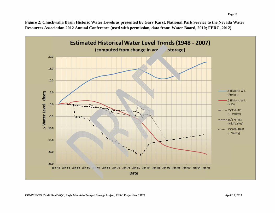
As part of their technical review and analysis of the Eagle Mountain water balance results, the NPS constructed comparative water balances for the Chuckwalla Basin during the previous 60 years of historical pumping in the basin, using the Eagle Mountain recharge estimate (12,700 afy) and the NPS’s extrapolated lower recharge estimate (3,013 afy). These historical water balances were constructed using information published in the Eagle Mountain Final EIS (FERC, 2012) and the Water Board EIR (Water Board, 2010) (See Figure 1). The purpose was to see what the historical effects on aquifer storage volume and equivalent changes to basin-wide water levels were during this period, and whether or not the results were consistent with available water level trends in the basin during this period. The results using the Eagle Mountain recharge estimate indicated that aquifer storage volume should have increased during this period by about +267,000 af, which roughly equates to an average water level rise of +18 feet across the basin. Conversely, the results using the NPS recharge estimate indicated that aquifer storage volume should have decreased during this period by about -314,000 af, which roughly equates to an average water level decline of -21 feet across the basin. Comparison of the estimated annual, basin-wide changes in water levels for both sets of results against available historical water level data for the basin suggests the results using the NPS’s lower recharge estimate are consistent with what appeared to be a general condition of declining water levels in much of the basin. The NPS’s historical water balance analysis suggests that (1) recharge of 12,700 afy for the Chuckwalla Basin may be greater than actual recharge and (2) the Chuckwalla Basin overall may have been experiencing overdraft conditions for several decades. (Karst, 2012b) Table 2: Comparison of Basin Recharge Estimates for Chuckwalla and Tributary Basins
Basin NPS Extrapolation
(afy)
Eagle Mountain Final EIS / Water Board EIR*
(afy)
Chuckwalla Valley Groundwater Basin
2,060 – 4,120
6,125
Pinto Valley Groundwater Basin
624 – 1,248
5,875
Orocopia Groundwater Basin
329 - 658
700
Total Chuckwalla Basin Recharge (from inflow and precipitation)
3,013 – 6,026
12,700
* The range of values determined was approximately 9,600 afy to about 15,000 afy. The single values presented were generally used in calculations. The NPS also used information contained in the Eagle Mountain documents concerning historic pumping volumes and water level recovery measurements from a well in the Pinto Basin (Well
COMMENTS: Draft Final WQC, Eagle Mountain Pumped Storage Project, FERC Project No. 13123 April 10, 2013
Page 9
3S/15E-4J1) to help verify its extrapolated recharge estimate for the Pinto Basin (Karst, 2012b). Historic drawdown of the Pinto Basin aquifer at that well was estimated to be -17.2 feet when pumping to supply the Kaiser mining operations ceased. Recovery of the water level in this well was approximately 3.6 feet during the 23 years since pumping in the basin stopped. Based on the NPS’s calculations, the volume of recharged water represented by the water level recovery during this period equates to an estimated annual basin recharge rate of 1,238 afy, which is within the range calculated for the Pinto Basin by the NPS’s extrapolation method (see Table 2). The close agreement of this recharge estimate with the NPS’s extrapolation method recharge estimate for the Pinto Basin lends support to the NPS’s recharge estimates for each of these three basins. The low natural discharge that has been identified from the Chuckwalla Basin also supports a lower recharge rate than has been published to date. Identified known natural discharge from the Chuckwalla Basin is estimated between 750 afy and 1,550 afy: this includes ET discharge from Palen Dry Lake at about 350 afy and groundwater outflow into the Palo Verde Mesa Groundwater Basin at between 400 afy and 1,200 afy. The NPS’s historic water balance analysis, using Eagle Mountain Final EIS recharge estimates, indicates an increase in storage of about 267,000 af should have occurred over the 60- year historical pumping period (FERC, 2012). If correct, this equates to an annual storage gain of about 4,450 afy, which should have been reflected in raising water levels in the basin, increased discharge by ET, and/or increased subsurface outflow from the basin. None of these three indicators is evident in the basin based on the best available information. This analysis further supports the idea that the higher recharge estimates (12,000 afy to 13,000 afy) may not be justified. New isotopic data recently published as part of the USGS Groundwater Ambient Monitoring and Assessment (GAMA) study (Mathany et al, 2012) suggests that the groundwater in the Chuckwalla Basin and surrounding study area basins is relatively old. Preliminary unpublished estimates (Wright, 2012) of an uncorrected carbon-14 age date for water from a well near Desert Center (western Chuckwalla Basin) under the GAMA study indicates the water to be over 15,000 years old. Similarly, preliminary results for a well near the Chuckwalla State Prison (eastern Chuckwalla Basin) indicated an uncorrected carbon-14 age of more than 28,000 years. Based on the USGS’s preliminary results for all of the basins in the GAMA study area, the average uncorrected carbon-14 age for groundwater in these basins (a total of 26) is about 11,000 years old. Furthermore, preliminary tritium age-dating results from the GAMA study for these same two sampling sites in the Chuckwalla Basin and elsewhere in the GAMA study area indicated very little modern-day recharge is occurring in the Chuckwalla Basin or in most of the other study area basins. The implication of this is important since it suggests that very little recharge is getting into the basin on a “human” time scale. This further indicates that water currently being produced for beneficial use is largely coming from storage and will not be readily replaced. This conclusion concurs with findings of the USGS study near the town of Joshua Tree, CA
COMMENTS: Draft Final WQC, Eagle Mountain Pumped Storage Project, FERC Project No. 13123 April 10, 2013
Page 10
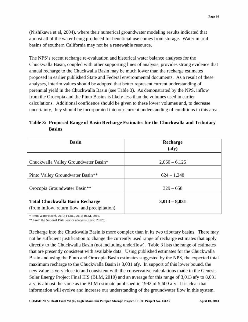
(Nishikawa et al, 2004), where their numerical groundwater modeling results indicated that almost all of the water being produced for beneficial use comes from storage. Water in arid basins of southern California may not be a renewable resource. The NPS’s recent recharge re-evaluation and historical water balance analyses for the Chuckwalla Basin, coupled with other supporting lines of analysis, provides strong evidence that annual recharge to the Chuckwalla Basin may be much lower than the recharge estimates proposed in earlier published State and Federal environmental documents. As a result of these analyses, interim values should be adopted that better represent current understanding of perennial yield in the Chuckwalla Basin (see Table 3). As demonstrated by the NPS, inflow from the Orocopia and the Pinto Basins is likely less than the volumes used in earlier calculations. Additional confidence should be given to these lower volumes and, to decrease uncertainty, they should be incorporated into our current understanding of conditions in this area. Table 3: Proposed Range of Basin Recharge Estimates for the Chuckwalla and Tributary Basins
Basin Recharge (afy)
Chuckwalla Valley Groundwater Basin*
2,060 – 6,125
Pinto Valley Groundwater Basin**
624 – 1,248
Orocopia Groundwater Basin**
329 – 658
Total Chuckwalla Basin Recharge (from inflow, return flow, and precipitation)
3,013 – 8,031
* From Water Board, 2010; FERC, 2012; BLM, 2010. ** From the National Park Service analysis (Karst, 2012b).
Recharge into the Chuckwalla Basin is more complex than in its two tributary basins. There may not be sufficient justification to change the currently used range of recharge estimates that apply directly to the Chuckwalla Basin (not including underflow). Table 3 lists the range of estimates that are presently consistent with available data. Using published estimates for the Chuckwalla Basin and using the Pinto and Orocopia Basin estimates suggested by the NPS, the expected total maximum recharge to the Chuckwalla Basin is 8,031 afy. In support of this lower bound, the new value is very close to and consistent with the conservative calculations made in the Genesis Solar Energy Project Final EIS (BLM, 2010) and an average for this range of 3,013 afy to 8,031 afy, is almost the same as the BLM estimate published in 1992 of 5,600 afy. It is clear that information will evolve and increase our understanding of the groundwater flow in this system.
COMMENTS: Draft Final WQC, Eagle Mountain Pumped Storage Project, FERC Project No. 13123 April 10, 2013
Page 11
The ongoing study, described below, will help inform this understanding and increase confidence in the growing body of work being done here. Estimated use and outflow from the basin ranges from about 9,000 afy to about 12,000 afy (BLM, 2010; BLM, 2011a; BLM, 2011b; FERC, 2012). Since existing outflow estimates exceed the maximum recharge being proposed, it is expected that the Chuckwalla Basin may be experiencing groundwater overdraft conditions to some degree. Future environmental documents should address the groundwater supply issues identified here for the Chuckwalla Basin and other arid basins of southern California. The BLM supports analysis and discussion of perennial yield that presents a full range of possible outcomes and consequences, so that State and Federal agencies can fully meet requirements of the California Environmental Quality Act and the National Environmental Policy Act. Conclusion Utility scale renewable energy development is rapidly becoming an important component of the nation’s energy production portfolio. This growth is particularly noticeable in the deserts of southern California where many projects have been approved or are being considered. Each of these projects carries with it a water demand that varies with the specific technology involved and its application. Where water is scarce, even small demands may have noticeable impacts. Water demand within the Riverside East SEZ is expected to range between a high of about 14,829 afy to a low of about 672 afy (Greer, et al, 2013). These volumes are equivalent to most or all of the groundwater outflow from the Chuckwalla Basin into the Palo Verde Mesa Groundwater Basin and into the Colorado River. The projections made in Greer, et al do not include the potential for the Eagle Mountain Project to further deplete groundwater resources. There is a real risk of harm to the BLM, its management goals in the Chuckwalla Basin, and renewable energy proponents. There is a real risk of harm to authorized users of Colorado River water. In a case study of the Chuckwalla Basin, understanding of the perennial yield is evolving and there continues to be uncertainty. At the heart of this issue is the estimation of groundwater recharge within the basin, which has tremendous importance to existing users of the local aquifer and the nearby Colorado River. New information and analysis suggests that adjustments in the calculated underflow from the Pinto and Orocopia Basins should be made. In making those adjustments, the proposed range of total recharge adds up to less than the current estimates of groundwater production from within the Chuckwalla Basin. Application of these revised values to the water balance calculation indicates the basin may be in overdraft. If nothing else was done, use of the conservative end of a range of values would be prudent. Consideration of this analysis, at the very least, provides greater uncertainty and risk in adhering to earlier, preliminary studies.
COMMENTS: Draft Final WQC, Eagle Mountain Pumped Storage Project, FERC Project No. 13123 April 10, 2013
Page 12
In an effort to further define impacts from solar development in arid landscapes, the BLM has initiated several studies. One is a large scale view of the Chuckwalla Basin in conjunction with Argonne National Laboratory. The other is a more focused study in cooperation with Lawrence Berkeley and Penn State, the USGS, and the NRCS to better understand conditions surrounding solar energy development in the Chuckwalla Basin. This work will help better define perennial yield, other current aquifer conditions, and potential impacts within the basin and to the adjoining Colorado River. Some of the tools developed under these efforts could be applied in other similar basins across southern California and to assist decision makers as they process and review future development projects. There is significant uncertainty regarding basin recharge rates and other parameters of the Chuckwalla Basin’s water balance, as documented above, including the relationship between pumping rates and aquifer drawdown. The current pumping thresholds referenced in Condition 5 may maintain or exacerbate that uncertainty. Historic pumping data may be incomplete for wells in the Chuckwalla Basin. There are no monitoring wells currently listed in the vicinity of the three Project supply wells to be used for the Eagle Mountain Project. Impacts of the proposed project on groundwater will be part of the cumulative impacts generated by multiple users in the Chuckwalla Basin. Those cumulative impacts, whatever their magnitude, will likely impact expected flows in the Colorado River. RECOMMENDATIONS
1. The BLM recommends that the Water Board, or an appropriate third party, re-evaluate and quantify the potential for impacts to flows in the Colorado River from groundwater pumping currently proposed within the Chuckwalla Basin. This effort should use best available science on this issue, for example, Leake, et al’s 2008 Superposition Model. This exercise would greatly enhance the ability of the Water Board to fully evaluate potential impacts to the Colorado River.
2. The BLM recommends that the Water Board, or an appropriate third party, re-evaluate their analysis of groundwater recharge and perennial yield in the Chuckwalla Basin in light of the uncertainties discussed above. The BLM recommends the use of either the proposed interim range of 3,013 afy to 8,031 afy for recharge, or the use of the more conservative endpoint of the range developed in the Eagle Mountain Project (Federal Energy Regulatory Commission) EIS / Water Board EIR of about 9,600 afy. This exercise would greatly enhance the ability of the Water Board to fully evaluate potential impacts to groundwater resources in the Chuckwalla Basin.
3. The BLM recommends that the Water Board will consider making the following changes
(in red and bold) to Condition 5. GROUNDWATER SUPPLY, from the Draft Final Water Quality Certification. Inclusion of this language will remove ambiguity and provide clear guidelines to limit overdraft damage to the aquifer should it be occur.
COMMENTS: Draft Final WQC, Eagle Mountain Pumped Storage Project, FERC Project No. 13123 April 10, 2013
Page 13
At a minimum, the monitoring plan shall be prepared to meet the following objectives and include the following provisions: Confirm that Project pumping is maintained at levels that are at or below the range of
historic pumping as presented in the Groundwater Supply Pumping Effects technical memorandum (GEI, 2009a). Maximum allowable drawdown below static water level shall not exceed 60 feet at any Project supply well. Maximum allowable drawdown below static water level shall not exceed 10 feet at any well within 1 ½ miles of a Project supply well. Water level shall be monitored hourly at all Project supply and monitor wells and data from this monitoring shall be reported quarterly. The Licensee shall track the pumping rate and duration associated with the Project supply wells and report the amount of water extracted quarterly. The groundwater monitoring network shall consist of both existing and new wells to assess changes in groundwater levels at: the Project supply wells; beneath the CRA in the upper Chuckwalla Valley Groundwater Basin and Orocopia Valley; at the mouth of Pinto Basin; and in areas east of the Project supply wells. At least one monitor well will be constructed for each Project supply well, will be located approximately 1 ½ miles to the east, and generally down gradient from the supply well. Monitor well location will require review and approval of the Deputy Director of the BLM and the Board. Wells shall be monitored quarterly for groundwater level, water quality, and the amount of water extracted.
The Licensee shall provide an annual report to the Board detailing both project and cumulative impacts to groundwater resources in the Chuckwalla Basin. This annual report will calculate a water balance and perennial yield for the Chuckwalla Basin, as defined by the California Department of Water Resources (CA-DWR, 2003), and shall be reviewed and approved by the Deputy Director of the BLM prior to submission to the Board.
{THE BALANCE OF CONDITION 5 UNCHANGED}
COMMENTS: Draft Final WQC, Eagle Mountain Pumped Storage Project, FERC Project No. 13123 April 10, 2013
Page 14
If there are any questions regarding these comments, please contact Frank McMenimen, Project Manager (760-833-7150, [email protected]) or Peter Godfrey, Hydrologist (951-697-5385, [email protected]). Sincerely, /s/ Teresa A. Raml Teresa A. Raml District Manager cc Federal Energy Regulatory Commission John Kalish, Field Manager, BLM Palm Springs / South Coast Field Office Enclosures
REFERENCES Figure 1 Figure 2
COMMENTS: Draft Final WQC, Eagle Mountain Pumped Storage Project, FERC Project No. 13123 April 10, 2013
Page 15
REFERENCES BLM, 2010. Plan Amendment / Final Environmental Impact Statement for the Genesis Solar
Energy Project, U.S. Department of the Interior, Bureau of Land Management, August 2010.
_____, 2011a. Desert Sunlight Solar Farm Project, California Desert Conservation Area Plan
Amendment and Final Environmental Impact Statement, U.S. Department of the Interior, Bureau of Land Management, April 2011.
_____, 2011b. Plan Amendment / Final EIS for the Palen Solar Power Project, U.S. Department
of the Interior, Bureau of Land Management, May 2011. _____, 2012. Desert Harvest Solar Project, Draft Environmental Impact Statement and Draft
CDCA Plan Amendment, U.S. Department of the Interior, Bureau of Land Management, April 2012.
BLM/DOE, 2012. Final Programmatic Environmental Impact Statement for Solar Energy
Development in Six Southwestern States, U.S. Department of the Interior, Bureau of Land Management and the U.S. Department of Energy, July 2012, (FES 12-24; DOE/EIS-0403).
CA-DWR, 1979. Sources of Powerplant Cooling Water in the Desert Area of Southern
California – Reconnaissance Study, State of California Department of Water Resources Bulletin 91-24, 1979, 55 p.
_____, 2003. California’s Groundwater Bulletin 118 Update 2003, State of California
Department of Water Resources Bulletin 118, October 2003, 246 p. Engineering Science (ES), 1990, Water and Wastewater Facilities Engineering Study, California
State Prison – Chuckwalla Valley, September 1990, cited in BLM, 2010. FERC, 2012. Eagle Mountain Pumped Storage Hydroelectric Project Final Environmental
Impact Statement, U.S. Federal Energy Regulatory Commission, January 2012, (FERC Project No. 13123). http://www.ferc.gov/industries/hydropower/enviro/eis/2012/01-30-12.asp#skipnav
Flint, A.L., Flint, L.E., Hevesi, J.A., and Blainey, J.M., 2004. Fundamental concepts of
recharge in the Desert Southwest: a regional modeling perspective, in Groundwater Recharge in a Desert Environment: the Southwestern United States, edited by J.F. Hogan,
COMMENTS: Draft Final WQC, Eagle Mountain Pumped Storage Project, FERC Project No. 13123 April 10, 2013
Page 16
F.M. Phillips, and B.R. Scanlon, Water Science and Applications Series, vol. 9 American Geophysical Union, Washington, D.C., p. 159-184.
Effects, Technical Memorandum Prepared by David Fairman, Richard Shatz, GEI Consultants, Inc., Revised October 23, 2009.
Karst, G., 2012a. Historical Water Budget and Water Level Data Analyses to Confirm Recharge
Estimates in Chuckwalla Valley, Presented at the Nevada Water Resources Association 2012 Annual Conference, March 5-8, 2012, U.S. Department of the Interior, National Park Service, Pacific West Region.
Karst, G., 2012b. Personal and written communication, Hydrologist, U.S. Department of the
Interior, National Park Service, Pacific West Region. Leake, S.A., Greer, W., Watt, D., and Weghorst, P., 2008. Use of Superposition Models to
Simulate Possible Depletion of Colorado River Water by Ground-Water Withdrawal: U.S. Geological Survey Scientific Investigations Report 2008-5189, 25 p.
Mathany, T.M., M.T. Wright, B.S. Beuttel, and K. Belitz, 2012. Groundwater-Quality Data in
the Borrego Valley, Central Desert, and Low-Use Basins of the Mojave and Sonoran Deserts Study Unit, 2008-2010; Results from the California GAMA Program: U.S. Geological Survey. Posted online at http://pubs.usgs.gov/ds/659/
Maxey, G.B., and Eakin, T.E., 1950. Ground Water in White River Valley, White Pine, Nye, and
Lincoln Counties, Nevada, Nevada State Engineer, Water Resources Bulletin 8, 59 p. Metzger, D.G., and Loeltz, O.J., 1973. Geohydrology of the Needles area, Arizona, California,
and Nevada: U.S. Geological Survey Professional Paper 486-J, 54p. Nishikawa, T., Izbicki, J.A., Hevesi, J.A., Stamos, C.L., and Martin, P., 2004. Evaluation of
geohydrologic framework, recharge estimates, and ground-water flow of the Joshua Tree area, San Bernardino County, California: U.S. Geological Survey Scientific Investigations Report 2004–5267, 115 p.
Owen-Joyce, S.J., Wilson, R.P., Carpenter, M.C., and Fink, J.B., 2000. Method to identify wells
that yield water that will be replaced by water from the Colorado River downstream from Laguna Dam in Arizona and California: U.S. Geological Survey Water-Resources Investigations Report 00-4085, 3 plates, 31 p.
COMMENTS: Draft Final WQC, Eagle Mountain Pumped Storage Project, FERC Project No. 13123 April 10, 2013
Page 17
Supreme Court, 2006. Consolidated Decree of the United States Supreme Court in Arizona v. California, 547 U.S. 150 (2006).
Report, State of California Water Resources Control Board, July 2010, (State Clearinghouse No. 2009011010; FERC Project No. 13123).
Wiele, S.M., Leake, S.A., Owen-Joyce, S.J., and McGuire, E.H., 2008. Update of the
accounting surface along the lower Colorado River: U.S. Geological Survey Scientific Investigations Report 2008-5113, 16 p.
Wilson, R.P., and Owen-Joyce, S.J., 1994. Method to identify wells that yield water that will be
replaced by Colorado River water in Arizona, California, Nevada, and Utah: U.S. Geological Survey Water-Resources Investigations Report 94-4005, 19 plates, 36 p.
Wright, M.T., 2012. Personal and written communication, Hydrologist, U.S. Department of the