NPS Form 10-900-b OMB No. 1024-0018 (March 1992) United States Department of the Interior National Park Service National Register of Historic Places Multiple Property Documentation Form This form is used for documenting multiple property groups relating to one or several historic contexts. See instructions in How to Complete the Multiple Property Documentation Form (National Register Bulletin 16B). Complete each item by entering the requested information. For additional space, use continuation sheets (Form 10-900-a). Use a typewriter, word processor, or computer to complete all items. _X___ New Submission ____ Amended Submission ======================================================================================================= A. Name of Multiple Property Listing ======================================================================================================= Historic and Historical Archaeological Resources of the Cherokee Trail of Tears ======================================================================================================= B. Associated Historic Contexts ======================================================================================================= (Name each associated historic context, identifying theme, geographical area, and chronological period for each.) See Continuation Sheet ======================================================================================================= C. Form Prepared by ======================================================================================================= name/title _Philip Thomason/Principal_(Historical Overview by Dr. Sara Parker )__________________________ organization ___Thomason and Associates___________ date__October 25, 2003 _________________________ street & number __P.O. Box 121225________ telephone _(615) 385-4960 ______________________________ city or town __Nashville___________________ state_TN ____ zip code_37212_ ======================================================================================================= D. Certification ======================================================================================================= As the designated authority under the National Historic Preservation Act of 1966, as amended, I hereby certify that this documentation form meets the National Register documentation standards and sets forth requirements for the listing of related properties consistent with the National Register criteria. This submission meets the procedural and professional requirements set forth in 36 CFR Part 60 and the Secretary of the Interior's Standards and Guidelines for Archeology and Historic Preservation. (___ See continuation sheet for additional comments.) _____________________________________________ ____________________ Signature and title of certifying official Date ______________________________________________ State or Federal agency and bureau ======================================================================================================= I hereby certify that this multiple property documentation form has been approved by the National Register as a basis for evaluating related properties for listing in the National Register. _______________________________________________ ___________________ Signature of the Keeper Date
Transcript
NPS Form 10-900-b OMB No. 1024-0018 (March 1992) United States Department of the Interior National Park Service National Register of Historic Places Multiple Property Documentation Form This form is used for documenting multiple property groups relating to one or several historic contexts. See instructions in How to Complete the Multiple Property Documentation Form (National Register Bulletin 16B). Complete each item by entering the requested information. For additional space, use continuation sheets (Form 10-900-a). Use a typewriter, word processor, or computer to complete all items. _X___ New Submission ____ Amended Submission ======================================================================================================= A. Name of Multiple Property Listing ======================================================================================================= Historic and Historical Archaeological Resources of the Cherokee Trail of Tears ======================================================================================================= B. Associated Historic Contexts ======================================================================================================= (Name each associated historic context, identifying theme, geographical area, and chronological period for each.) See Continuation Sheet ======================================================================================================= C. Form Prepared by ======================================================================================================= name/title _Philip Thomason/Principal_(Historical Overview by Dr. Sara Parker)__________________________ organization ___Thomason and Associates___________ date__October 25, 2003_________________________ street & number __P.O. Box 121225________ telephone _(615) 385-4960______________________________ city or town __Nashville___________________ state_TN____ zip code_37212_ ======================================================================================================= D. Certification ======================================================================================================= As the designated authority under the National Historic Preservation Act of 1966, as amended, I hereby certify that this documentation form meets the National Register documentation standards and sets forth requirements for the listing of related properties consistent with the National Register criteria. This submission meets the procedural and professional requirements set forth in 36 CFR Part 60 and the Secretary of the Interior's Standards and Guidelines for Archeology and Historic Preservation. (___ See continuation sheet for additional comments.) _____________________________________________ ____________________ Signature and title of certifying official Date ______________________________________________ State or Federal agency and bureau ======================================================================================================= I hereby certify that this multiple property documentation form has been approved by the National Register as a basis for evaluating related properties for listing in the National Register. _______________________________________________ ___________________ Signature of the Keeper Date
======================================================================================================= Table of Contents for Written Narrative ======================================================================================================= Provide the following information on continuation sheets. Cite the letter and the title before each section of the narrative. Assign page numbers according to the instructions for continuation sheets in How to Complete the Multiple Property Documentation Form (National Register Bulletin 16B). Fill in page numbers for each section in the space below. Page Numbers E. Statement of Historic Contexts (If more than one historic context is documented, E-1 - E-84 present them in sequential order.) F. Associated Property Types (Provide description, significance, and registration F-1 - F-34 requirements.) G. Geographical Data G-1 H. Summary of Identification and Evaluation H-1 - H-2 Methods (Discuss the methods used in developing the multiple property listing.) I. Major Bibliographical References (List major I-1 - I-6 written works and primary location of additional documentation: State Historic Preservation Office, other State agency, Federal agency, local government, university, or other, specifying repository.) ======================================================================================================= Paperwork Reduction Act Statement: This information is being collected for applications to the National Register of Historic Places to nominate properties for listing or determine eligibility for listing, to list properties, and to amend existing listings. Response to this request is required to obtain a benefit in accordance with the National Historic Preservation Act, as amended (16 U.S.C. 470 et seq.). Estimated Burden Statement: Public reporting burden for this form is estimated to average 120 hours per response including the time for reviewing instructions, gathering and maintaining data, and completing and reviewing the form. Direct comments regarding this burden estimate or any aspect of this form to the Chief, Administrative Services Division, National Park Service, P.0. Box 37127, Washington, DC 20013-7127; and the Office of Management and Budget, Paperwork Reductions Project (1024-0018), Washington, DC 20503.
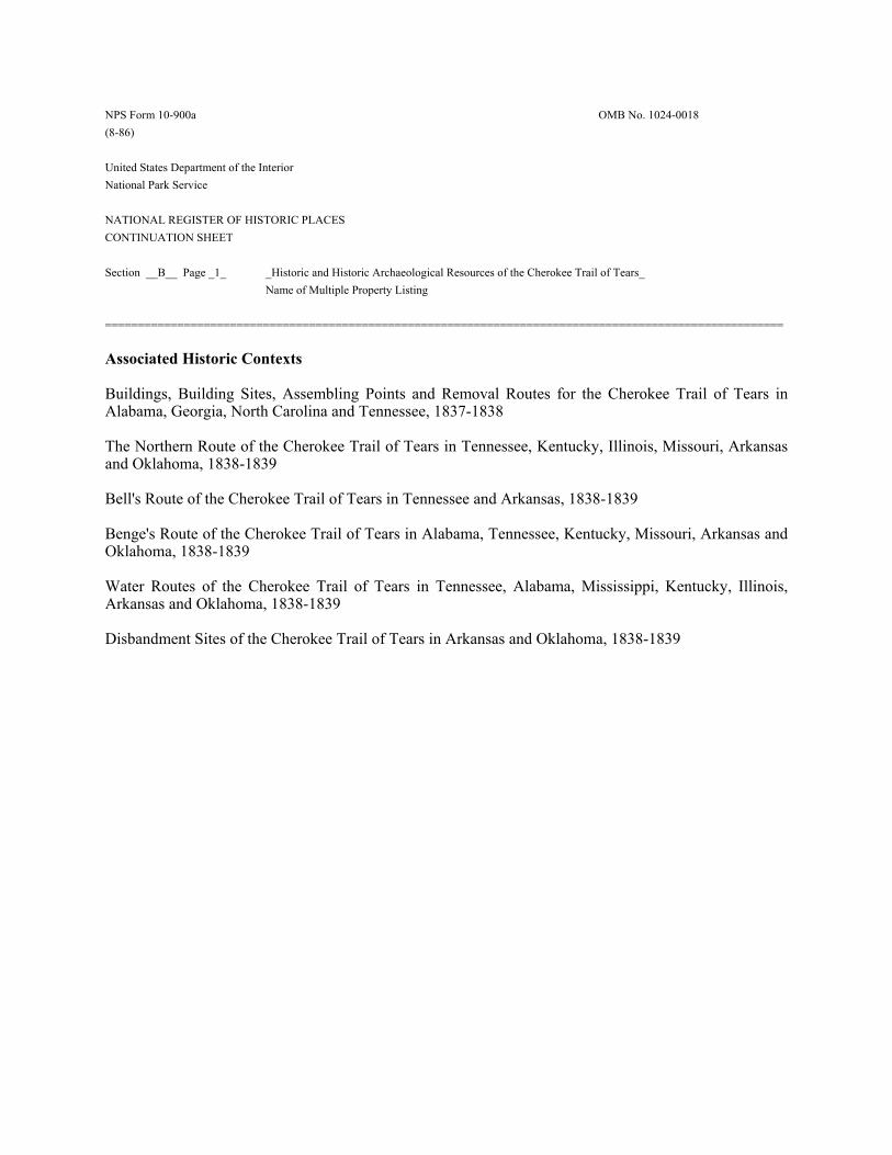
NPS Form 10-900a OMB No. 1024-0018 (8-86) United States Department of the Interior National Park Service NATIONAL REGISTER OF HISTORIC PLACES CONTINUATION SHEET Section __B__ Page _1_ _Historic and Historic Archaeological Resources of the Cherokee Trail of Tears_ Name of Multiple Property Listing ======================================================================================================= Associated Historic Contexts Buildings, Building Sites, Assembling Points and Removal Routes for the Cherokee Trail of Tears in Alabama, Georgia, North Carolina and Tennessee, 1837-1838 The Northern Route of the Cherokee Trail of Tears in Tennessee, Kentucky, Illinois, Missouri, Arkansas and Oklahoma, 1838-1839 Bell's Route of the Cherokee Trail of Tears in Tennessee and Arkansas, 1838-1839 Benge's Route of the Cherokee Trail of Tears in Alabama, Tennessee, Kentucky, Missouri, Arkansas and Oklahoma, 1838-1839 Water Routes of the Cherokee Trail of Tears in Tennessee, Alabama, Mississippi, Kentucky, Illinois, Arkansas and Oklahoma, 1838-1839 Disbandment Sites of the Cherokee Trail of Tears in Arkansas and Oklahoma, 1838-1839
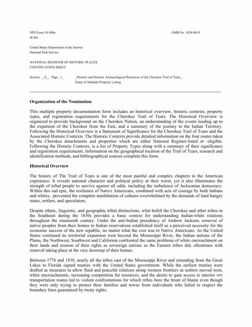
NPS Form 10-900a OMB No. 1024-0018 (8-86) United States Department of the Interior National Park Service NATIONAL REGISTER OF HISTORIC PLACES CONTINUATION SHEET Section __E__ Page _1_ _Historic and Historic Archaeological Resources of the Cherokee Trail of Tears_ Name of Multiple Property Listing ======================================================================================================= Organization of the Nomination This multiple property documentation form includes an historical overview, historic contexts, property types, and registration requirements for the Cherokee Trail of Tears. The Historical Overview is organized to provide background on the Cherokee Nation, an understanding of the events leading up to the expulsion of the Cherokee from the East, and a summary of the journey to the Indian Territory. Following the Historical Overview is a Statement of Significance for the Cherokee Trail of Tears and the Associated Historic Contexts. The Historic Contexts provide detailed information on the four routes taken by the Cherokee detachments and properties which are either National Register-listed or -eligible. Following the Historic Contexts, is a list of Property Types along with a summary of their significance and registration requirements. Information on the geographical location of the Trail of Tears, research and identification methods, and bibliographical sources complete this form. Historical Overview The history of The Trail of Tears is one of the most painful and complex chapters in the American experience. It reveals national character and political policy at their worst, yet it also illuminates the strength of tribal people to survive against all odds, including the turbulence of Jacksonian democracy. Within this sad epic, the resilience of Native Americans, combined with acts of courage by both Indians and whites, prevented the complete annihilation of cultures overwhelmed by the demands of land hungry states, settlers, and speculators. Despite ethnic, linguistic, and geographic tribal distinctions, what befell the Cherokee and other tribes in the Southeast during the 1830s provides a basic context for understanding Indian-white relations throughout the nineteenth century. Under the anti-Indian presidency of Andrew Jackson, removal of native peoples from their homes to Indian reservations established itself as a perceived necessity for the economic success of the new republic, no matter what the cost was to Native Americans. As the United States continued its territorial expansion west beyond the Mississippi River, the Indian nations of the Plains, the Northwest, Southwest and California confronted the same problems of white encroachment on their lands and erosion of their rights as sovereign nations as the Eastern tribes did, oftentimes with removal taking place at the very doorstep of their homes. Between 1776 and 1830, nearly all the tribes east of the Mississippi River and extending from the Great Lakes to Florida signed treaties with the United States government. While the earliest treaties were drafted as measures to allow fluid and peaceful relations along western frontiers as settlers moved west, white encroachments, increasing competition for resources, and the desire to gain access to interior NPS transportation routes led to violent confrontations for which tribes bore the brunt of blame even though they were only trying to protect their families and towns from individuals who failed to respect the boundary lines guaranteed by treaty rights.
Form 10-900a OMB No. 1024-0018 (8-86) United States Department of the Interior National Park Service NATIONAL REGISTER OF HISTORIC PLACES CONTINUATION SHEET Section __E__ Page _2_ _Historic and Historic Archaeological Resources of the Cherokee Trail of Tears_ Name of Multiple Property Listing
By the 1830s, pressure to open interior lands for settlement and resource development was intrinsically a part of Jackson's America. Tennessean Andrew Jackson was a strong proponent of Indian removal. As a military leader in the early 1800s, Jackson had defeated factions of the Creek and Seminole nations in the Southeast, and between 1814 and 1824 he was instrumental in negotiating numerous treaties with southern tribes to exchange their eastern lands for lands in the west. In 1828 Jackson was elected president of the United States. In this powerful position, Jackson successfully pushed the Indian Removal Act through Congress in May 1830, which initiated the formal removal of Native Americans from the Southeastern United States. The Act was to “provide for an exchange of lands with the Indians residing in any of the states or territories, and for their removal west of the river Mississippi.”1 Directed primarily at southern tribes, including the Creeks, Seminoles, Chickasaws, Choctaws, and Cherokees, the act gave the president authority to negotiate treaties with the tribes in order to secure their removal to the West. According to the Act removal was supposed to be voluntary, tribes were to be compensated for their improved lands, and the United States government was to provide the Indians with aid and assistance for the first year following removal. This single act of legislation served as the foundation for removal policies and treaties that resulted in the exodus of Native Americans from the southeastern United States, which is manifested in the Trail of Tears. The majority of Indians resisted the exchange of eastern for western lands “offered” in the Indian Removal Act and were eventually forced to leave. In his annual message to Congress in December of 1835, Jackson stated his firm intention to remove the indigenous people who remained east of the Mississippi River to lands west of Missouri and Arkansas. In his annual message to Congress in December 1835, he stated:
The plan of removing the aboriginal people who yet remain within the settled portions of the United States to the country west of the Mississippi approaches its consummation. It was adopted on the most mature consideration of the condition of this race…All preceding experiments for the improvement of the Indians have failed. It seems now to be an established fact that they can not [sic] live in contact with a civilized community and prosper.2
Jackson's congressional message revealed a troubling disregard for the reality of Southern tribes during the 1830s since his plans for removal specifically and most forcefully targeted the Cherokees, Choctaws, Creeks, Chickasaws and Seminoles. Collectively referred to as the Five
1U.S. Government, Indian Removal Act of 1830, CHAP. CXLVIII. 2Francis Paul Prucha, ed., Documents in United States Indian Policy. Second Edition. (Lincoln and London: University of Nebraska Press,1990) , 71; Robert V. Remini, Andrew Jackson and His Indian Wars (New York, NY: Viking, 2001), passim.
NPS Form 10-900a OMB No. 1024-0018 (8-86) United States Department of the Interior National Park Service NATIONAL REGISTER OF HISTORIC PLACES CONTINUATION SHEET Section __E__ Page _3_ _Historic and Historic Archaeological Resources of the Cherokee Trail of Tears_ Name of Multiple Property Listing
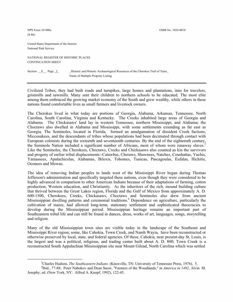
Civilized Tribes, they had built roads and turnpikes, large homes and plantations, inns for travelers, gristmills and sawmills. Many sent their children to northern schools to be educated. The most elite among them embraced the growing market economy of the South and grew wealthy, while others in these nations found comfortable lives as small farmers and livestock owners. The Cherokee lived in what today are portions of Georgia, Alabama, Arkansas, Tennessee, North Carolina, South Carolina, Virginia and Kentucky. The Creeks inhabited large areas of Georgia and Alabama. The Chickasaws' land lay in western Tennessee, northern Mississippi, and Alabama; the Choctaws also dwelled in Alabama and Mississippi, with some settlements extending as far east as Georgia. The Seminoles, located in Florida, formed an amalgamation of dissident Creek factions, Miccosukees, and the descendants of tribes whose populations had been decimated through contact with European colonists during the sixteenth and seventeenth centuries. By the end of the eighteenth century, the Seminole Nation included a significant number of Africans, most of whom were runaway slaves.3 Like the Seminoles, the Cherokees, Choctaws, Creeks and Chickasaws also counted as kin the survivors and progeny of earlier tribal displacements--Catawbas, Cheraws, Shawnees, Natchez, Coushattas, Yuchis, Yamassees, Apalachicolas, Alabamas, Biloxis, Tohomes, Tunicas, Pascagoulas, Eufalas, Hichitis, Oconees and Mowas. The idea of removing Indian peoples to lands west of the Mississippi River began during Thomas Jefferson's administration and specifically targeted these nations, even though they were considered to be highly advanced in comparison to other American Indians because of their adaptations of farming, cotton production, Western education, and Christianity. As the inheritors of the rich, mound building culture that thrived between the Great Lakes region, Florida and the Gulf of Mexico from approximately A. D. 600-1500, Cherokees, Creeks, Chickasaws, Choctaws and Seminoles also drew from ancient Mississippian dwelling patterns and ceremonial traditions.4 Dependence on agriculture, particularly the cultivation of maize, had allowed long-term, stationary settlement and sophisticated theocracies to develop during the Mississippian period. Mississippian heritage remains an important part of Southeastern tribal life and can still be found in dances, dress, works of art, languages, songs, storytelling and religion. Many of the old Mississippian town sites are visible today in the landscape of the Southeast and Mississippi River region; some, like Cahokia, Town Creek, and Nanih Wayia, have been reconstructed or otherwise preserved by local, state, and federal agencies. Of these, Cahokia, near present-day St. Louis, is the largest and was a political, religious, and trading center built about A. D. 800; Town Creek is a reconstructed South Appalachian Mississippian site near Mount Gilead, North Carolina which was settled
3Charles Hudson, The Southeastern Indians. (Knoxville, TN: University of Tennessee Press, 1976), 5. 4Ibid., 77-88; Peter Nabokov and Dean Snow, "Farmers of the Woodlands," in America in 1492, Alvin M. Josephy, ed. (New York, NY: Alfred A. Knopf, 1992), 122-45.
NPS Form 10-900a OMB No. 1024-0018 (8-86) United States Department of the Interior National Park Service NATIONAL REGISTER OF HISTORIC PLACES CONTINUATION SHEET Section __E__ Page _4_ _Historic and Historic Archaeological Resources of the Cherokee Trail of Tears_ Name of Multiple Property Listing ======================================================================================================= around A. D. 1300. Nanih Wayia in Mississippi is the site where the Chickasaws and Choctaws, once united as a people, parted ways and where the Choctaws built a large temple mound. The Choctaws consider Nanih Wayia their birthplace. The Chickasaws, who had traveled in company with the Choctaws from the north sometime around A. D. 900, established their towns in northern Mississippi and western Alabama. Until 1805, they also controlled lands as far east as present-day Nashville, Tennessee. Creeks, who speak both Hitchiti and a Muskogean-based language similar to that of the Choctaws and Chickasaws, were also at one time united with them.5
All of these nations endured enormous suffering during the Removal era, but it was the Cherokee who experienced the greatest loss of life and the tribe with whom the Trail of Tears is most often associated. They called themselves Ani'Yun'wiya, or the Principal People. The name Cherokee appears to be an English translation from a 1557 Portuguese narrative of Hernando de Soto's expedition, in which they were called Chalaque. Cherokees today call their Iroquoian-based language Tsalagi and their exodus into the Trans-Mississippi West nunahi-duna-dio-hilu-i, "the trail where they cried."The Cherokee who survived the journey along the Trail of Tears brought with them to Oklahoma the sacred fire of the Old Nation, which they rekindled along the way in keeping with their ancient tradition. They also brought the syllabary invented by Sequoyah during the 1820s, continuing to use it in their letters and publications into the present day. Cherokee is still spoken in Oklahoma, where most of the Nation settled after 1838, and in North Carolina, where descendants of the approximately 400 Cherokee who were permitted to stay primarily on the Qualla and Snowbird reservations. Since they lived outside the boundaries of the Cherokee Nation by terms of an 1819 treaty, the Qualla Indians were not required to emigrate and were permitted to remain in North Carolina. Cherokee remains one of the most widely spoken American Indian languages, with about 10,000 speakers in Oklahoma and 1,200 in North Carolina.6 To fully comprehend the economic, emotional, and spiritual impact removal had upon the many thousands of people it uprooted, divided, and sent into the Trans-Mississippi West, it is essential to understand both the time and the landscape in which it occurred. The population pressures that brought about this fate originated with global forces set in motion by European exploration and colonization. Spanish expeditions under Juan Ponce de Leon, Panfilo de Narvaez, and Hernando de Soto arrived along the Gulf Coast during the first half of the sixteenth century. Seeking gold and other valuable minerals, these individuals were not kindly sojourners. Despite the welcoming hospitality of the many tribes they encountered, the Spaniards looted villages, captured some of their hosts as slaves, murdered others, and
5Hudson, The Southeastern Indians, 83; Richard White, The Roots of Dependency: Subsistence, Environment, and Social Change Among Choctaws, Pawnees, and Navajos. (Lincoln and London: University of Nebraska Press, 1983), 7. 6James M. Crawford, "Southeastern Indian Languages," Studies in Southeastern Indian Languages (Athens, GA: University of Georgia Press, 1975), 23.
NPS Form 10-900a OMB No. 1024-0018 (8-86) United States Department of the Interior National Park Service NATIONAL REGISTER OF HISTORIC PLACES CONTINUATION SHEET Section __E__ Page _5_ _Historic and Historic Archaeological Resources of the Cherokee Trail of Tears_ Name of Multiple Property Listing ======================================================================================================= left behind a legacy of disease and distrust that shaped future relations between Native Americans and Europeans.7 By the early seventeenth century, significant numbers of Spanish, French, and British merchants, soldiers, hunters and travelers began to arrive in the Southeast. Many of them penetrated deep into the Indian nations via the Chattahoochee, French Broad, and Mississippi rivers. Colonial era contact with Europeans affected Southeastern native peoples biologically through the introduction of diseases such as smallpox and measles, while trade transformed native societies through the introduction of market economy goods such as liquor, guns, manufactured cloth, and iron utensils. Trade also brought about an adaptation of chattel slavery and increased the number of marriages between non-Indian men and Native American women. 8
The tensions arising from market relations with colonial governments competing for resources led to raiding and warfare and destabilized tribal governments and intertribal relations. They also very quickly created a general market for native lands as more and more Europeans, the English in particular, arrived along the Atlantic seaboard. In combination, epidemic diseases, increased white populations, and warfare resulted in mass native depopulation, destruction of crops, and food scarcity; increased hunting of deer and other animals for profit-driven European markets also seriously depleted food sources, eventually forcing the acceptance of domesticated animals such as hogs, cattle, and chickens into the Southeastern tribal landscape.9
As difficult as war and trade made life, and as far reaching as the social transformations were, most devastating to the tribes' survival and well being were the treaties which ceded large tracts of land to non-Indians. Treaties allowed white settlers to build cabins, forts, trading posts and roads in close proximity to Native American towns, within surrounding hunting peripheries, and in the fertile river valleys of the Carolina backcountry and Cumberland regions. Despite the many concessions and agreements Indian nations made between 1721 and 1835, treaty rights and boundaries were seldom respected, and payments rarely equaled what the treaties promised, leading to distrust and tribal factionalism increasingly opposed to treaty making.
7 White, The Roots of Dependency, 7. 8 Theda Perdue, Slavery and the Evolution of Cherokee Society, 1540-1866 (Knoxville, TN: University of Tennessee Press, 1979), 45-61. 9 Gary C. Goodwin, "Cherokees in Transition: A Study of Changing Culture and Environment Prior to 1775" (Chicago, IL: University of Chicago Department of Geography Research Paper No. 181, 1977), 1-5.
NPS Form 10-900a OMB No. 1024-0018 (8-86) United States Department of the Interior National Park Service NATIONAL REGISTER OF HISTORIC PLACES CONTINUATION SHEET Section _E___ Page _6_ _Historic and Historic Archaeological Resources of the Cherokee Trail of Tears_ Name of Multiple Property Listing ======================================================================================================= As the number of speculators, traders, and non-Indian settlers in the Southeast grew, so did the pressures of conflicting beliefs about indigenous peoples' right to possess their lands. Many whites felt that native peoples did not make adequate use of their land, that they used it only for hunting and gathering and practiced no agriculture or permanent dwellings. Despite the abundant physical evidence to the contrary, this pervasive stereotype of all Native Americans as nomadic peoples shaped political thought, speech, writing and policy throughout the nineteenth century. Although the Indian Removal Act was not passed until 1830, the 1775 Treaty of Sycamore Shoals set the stage 55 years earlier by providing white settlers with a route that led west, deep into Indian country.10 Signed just prior to the outbreak of the Revolutionary War, it provided for a road to be constructed that would allow the safe passage of settlers who wanted to move west from Virginia and the Carolinas into Kentucky. During this period, the Cherokee Nation was divided into three districts, the Lower towns, the Middle or Valley towns, and the Overhill towns, primarily for the convenience of colonial traders. The three regions were united under the leadership of Attakullakulla, who was also called The Little Carpenter, Oconostota, a war leader known as The Great Warrior, and Nan'ye hi, better known as Nancy Ward. Ward was the Ghigau or Beloved Woman, whose duty it was to settle disputes that could not be worked out at the town council level by members of the seven Cherokee clans. These leaders resided in Chota, the Cherokee capital located in the Overhill region along the Little Tennessee River, about 50 miles south of present-day Knoxville. Chota, which translates as the Meeting Place, became a vibrant, multicultural hub of social, political, and ceremonial activity between 1755 and 1784. The town was destroyed during the Revolution, largely because of its proximity to the new white settlements. A small monument marks a portion of the site today; most of Chota was excavated prior to its inundation by Tellico Dam in 1979. After Chota was burned by Revolutionary Army soldiers, the Cherokee established an interim capital at Ustanali, then issued a resolution in the 1820s to establish New Echota in Georgia as the Nation's capital.11
Attakullakulla and Oconostota died during the Revolution. During that same period, Ward and her family were among the Cherokee rounded up and held prisoners on the Long Island of Holston (part of what is now Kingsport, Tennessee), then forced to move south to an area along the Hiwassee River. For the
10 James Paul Pate, "The Chickamaugas: A Forgotten Segment of Resistance on the Southern Frontier," Ph.D. dissertation (Mississippi State University, 1969), 58-65,128; ; William G. McLoughlin, Cherokee Renascence in the New Republic (Princeton, NJ: Princeton University Press, 1986), 80-81; Sara G. Parker, "The Transformation of Cherokee Appalachia, 1755-1808," (Ph.D. dissertation, Berkeley, CA, 1991), 24-37. 11 Brett Riggs, Staff Archaeologist, Eastern Band of Cherokees, personal communication, July 6, 2001.
NPS Form 10-900a OMB No. 1024-0018 (8-86) United States Department of the Interior National Park Service NATIONAL REGISTER OF HISTORIC PLACES CONTINUATION SHEET Section __E__ Page _7_ _Historic and Historic Archaeological Resources of the Cherokee Trail of Tears_ Name of Multiple Property Listing ======================================================================================================= remainder of Ward's life, she appeared at treaty councils or sent a speaker on her behalf to plead against any sales of Cherokee lands to whites.
Encouraged by the 1770 Treaty of Hard Labor, which had opened more than 9,000 square miles between the Holston and Cumberland rivers, ever-growing numbers of white settlers moved through western Virginia towards Cherokee towns in the years immediately preceding the Revolutionary War. They were joined by others who migrated from central North Carolina after the Battle of Alamance. In early 1771, at Attakullakulla's request, the boundary lines were surveyed by John Donelson, who would later become one of the founders of Nashville. Donelson's survey determined that the settlers were living within the borders of the Cherokee Nation, but they refused to move, even after being ordered to do so by the Commonwealth of Virginia.12
The Sycamore Shoals "treaty" was in reality a private sale of approximately half of the hunting grounds shared by Cherokees, Creeks, Chickasaws and Shawnees to a group of speculators under the leadership of Richard Henderson, a land speculator and North Carolina judge instrumental in the white settlement of Kentucky by virtue of his role in the Transylvania Company. In order to obtain the Cherokees' signatures, Henderson convinced the elder headmen that they were simply providing an easement along the northern boundary of their country which would allow the safe passage of white families who desired to emigrate to lands in Ken-to-ke (Kentucky), beyond the Cherokees' domain. James McCormick, a mixed blood interpreter present during the negotiations, tried to stop the headmen from signing the document, but Attakullakulla and other Overhill Cherokee put their marks on the contract, hoping to appease the whites by allowing them to bypass Cherokee towns, avoid conflict, and secure Chota from desecration. Despite the Proclamation of 1763, which forbade any white migration across the Allegheny and Appalachian mountains, explorers, hunters, and survey parties continued to move towards Kentucky. Westward moving pioneers, finding the Overhill country fertile and abundant with game, proceeded to build cabins, settlements, and forts within the borders of the Cherokee Nation and in the hunting periphery. Much of this land had already been surveyed during the 1750s by George Washington and Christopher Gist, Sequoyah's grandfather, under the auspices of the Ohio Company. Permanent settlers were led into the regions by Daniel Boone, one of a number of "Overmountain Men" hired by Henderson. Grants were subsequently issued by the incipient State of Virginia to hundreds of whites who, by settling and making "improvements," claimed the acreage as their own. Known as the Watauga Settlement, it became part of the short-lived State of Franklin.13 When Tennessee declared statehood in 1796, this land fell within its borders.
12 Lord Dunmore to William Dartmouth, May 16, 1774. North Carolina Records, Vol.10, 763-83; C.O. Vol. 5, 1352. 13 Samuel Cole Williams, History of the Lost State of Franklin (Johnson City, TN, 1924), passim.
NPS Form 10-900a OMB No. 1024-0018 (8-86) United States Department of the Interior National Park Service NATIONAL REGISTER OF HISTORIC PLACES CONTINUATION SHEET Section __E__ Page _8_ _Historic and Historic Archaeological Resources of the Cherokee Trail of Tears_ Name of Multiple Property Listing =======================================================================================================
During the Revolution, land warrants were issued as enticements for soldiers to enlist in the Continental Army, adding about 2,000 more white settlers to the region, many of whom the British-allied Chickamauga Cherokee fought against during the war. Claimants of these warrants, and also of grants issued just prior to the war, included George Washington, James Monroe, Patrick Henry, Joseph Martin and Daniel Boone. In 1784, Thomas Jefferson directed Joseph Martin, who was married to Nancy Ward's daughter, Elizabeth (Betsy), to negotiate with the Cherokee for more land between the Carolinas and the Mississippi, with the intention of establishing United States sovereignty over the region. Jefferson believed that such a purchase would improve the ease with which goods, cotton in particular, could be shipped to overseas markets. It would also help to fulfill the land warrants issued to Revolutionary War veterans and their heirs. In 1792, all Virginia grants west of Big Sandy River were transferred to the Commonwealth of Kentucky. In 1805, the United States agreed to pay the Cherokee $11,000, plus an annuity of $3,000 for the 5.2 million acres located between the Cherokee town of Tellico, Big Sandy Valley, and eastern Kentucky. In all, 572 grants and 1331 warrants were issued to settlers.14 The continuing erosion of the homelands through such treaties fractured the Cherokee Nation and brought about the dissident response of many of its younger citizens, who, recognizing the threat the Americans presented, formed the secessionist Chickamaugas under the leadership of Dragging Canoe. They were among the first Cherokee to voluntarily move west into the Arkansas Territory. With the Wilderness and Cumberland roads on the northern perimeter and the Natchez Trace and Federal Turnpike penetrating from the south and east, Cherokee country became extraordinarily vulnerable to the further incursions of whites. By 1835, the Cherokee had signed a total of 23 treaties that reduced their land base by 75 per cent and pushed them almost one hundred miles south and west.15 The last of these, the Treaty of New Echota, was the document that spelled doom for the Cherokee who wished to remain in their homes. Most Cherokee were united in opposition to removal under the leadership of Chief John Ross, who, despite being only one-eighth Cherokee, was a significant leader among the Cherokee people. Signed December 29, 1835, the Treaty of New Echota forfeited all remaining Cherokee lands east of the Mississippi River to the federal government. In return, the Cherokee were to be paid five million dollars. The treaty was orchestrated and signed by unsanctioned representatives of the Nation, with fewer than 100 of the 17,000 Cherokee who remained in the east in attendance.
14 Draper Mss., 46J57; William Rouse Jillson, Old Kentucky Entries and Deeds (Louisville, KY, 1926), 1. 15McLoughlin, Cherokee Renascence in the New Republic, 25, 29.
NPS Form 10-900a OMB No. 1024-0018 (8-86) United States Department of the Interior National Park Service NATIONAL REGISTER OF HISTORIC PLACES CONTINUATION SHEET Section __E__ Page _9_ _Historic and Historic Archaeological Resources of the Cherokee Trail of Tears_ Name of Multiple Property Listing ======================================================================================================= The Treaty Party was led by Major Ridge (The Ridge), his son John Ridge, Elias Boudinot (Buck Watie), editor of The Cherokee Phoenix, the first independent Indian-published newspaper in the United States, and Andrew Ross, John Ross' brother. The elder Ridge was persuaded by his son to become part of the pro-treaty faction; both John Ridge and Elias Boudinot were educated at Cornwall Seminary in Connecticut; all three were assassinated in 1839 for their pro-removal politics. John Ross was able to obtain 14,910 Cherokee signatures protesting the treaty and immediately traveled to Washington to try to convince the United States Senate not to ratify it.16 At the time, there was a substantial amount of nationwide public support for Ross's position and less than overwhelming enthusiasm for Removal within the Senate. The treaty passed by only one vote and was subsequently signed into law by Andrew Jackson on May 23, 1836. Ross again circulated a petition in protest, this time obtaining 15,665 Cherokee signatures. At its inception, Removal was intended to be a voluntary exchange of land. However, it was soon apparent that the majority of the tribes were unwilling to cede their homes for unfamiliar western territory. As Grant Foreman stated over 70 years ago in Indian Removal:
They loved their streams and valleys, their hills, and forests, their fields, and herds, their homes and firesides, families and friends. They cherished a passionate attachment for the earth that held the bones of their ancestors and relatives. The trees that shaded their homes, the cooling spring that ministered to every family, friendly watercourses, familiar trails and prospects, bush grounds, and their property and their friends. 17
Under the pressure of ever increasing white populations, some Cherokee voluntarily moved to Missouri and Arkansas well before the era of Removal. In 1782, a small group of Cherokee sought permission from Don Estevan Miro, governor of the Louisiana Territory, to settle west of the Mississippi in lands still controlled by Spain. In the 1790s, following the Treaty of Hopewell, more than 600 Cherokee under the leadership of The Bowl built settlements along the St. Francis River in Arkansas and southeastern Missouri; by 1803, an estimated 6,000 Cherokee were living in this region. 18
16Benjamin C. Nance, “The Trail of Tears in Tennessee: A Study of the Routes Used During the Cherokee Removal of 1838.” (Tennessee Department of Environment and Conservation, Division of Archaeology, 2001), 11-12; Stanley Hoig, Night of the Cruel Moon: Cherokee Removal and the Trail of Tears (New York: Facts on File, 1996), 68-73. 17 Grant Foreman, Indian Removal, (Norman, OK: 1932), preface. 18 Hoig, Night of the Cruel Moon, 16-17, 56-57; Nance, "The Trail of Tears in Tennessee," 11.
NPS Form 10-900a OMB No. 1024-0018 (8-86) United States Department of the Interior National Park Service NATIONAL REGISTER OF HISTORIC PLACES CONTINUATION SHEET Section __E__ Page _10_ _Historic and Historic Archaeological Resources of the Cherokee Trail of Tears_ Name of Multiple Property Listing =======================================================================================================
By 1805, some Cherokee combined hunting expeditions with visits to relatives in Arkansas. They also aided Western Cherokee in fighting the Osage, whose territory was encroached by the Cherokee moving into Missouri and Arkansas. In 1808, approximately 1,000 Chickamauga Cherokee relocated to Arkansas to escape the white squatters whose incursions continually violated the Cherokees' treaty rights and made peace impossible. Between 1810 and 1819, Cherokee under the leadership of Chief Tahlonteskee and John Jolly emigrated. The Treaty of Turkey Town signed in 1817 gave the earliest emigrants, or Old Settlers, as they came to be called, title to land in northwestern Arkansas, but in 1828 they were forced to exchange the Arkansas land for territory further west in Oklahoma. Most of these emigrants traveled along the trail that would become the main route taken in 1838, crossing Tennessee and Kentucky into Illinois, Missouri, and Arkansas. 19 Most Cherokee, however, along with their Creek, Choctaw, Chickasaw and Seminole neighbors, preferred to remain in the East, where their roots were strong and life was familiar. Architecture, creative arts, culture, spirituality and identity were fixed in the Southeastern landscape.20 They had created their nations and way of life in balance with their beliefs and resources, with cultivated fields, communal gardens, and borderlands rich in nut trees, timber, and game. By the early nineteenth century, a number of Cherokee, Creek, and Choctaw families had turned from small farming to participating in a plantation lifestyle which mirrored that of their white neighbors, often surpassing them in wealth, market success, and number of black slaves they held. Many had converted to Christianity, attended school in New England, and married white men and women. At the same time, they maintained their ceremonial life, religion, culture, and tribal laws. Their lands and homes were beautiful and comfortable, the graves of their ancestors were close by, their orchards and fields were productive and profitable. Despite frequent confrontations with white settlers, they wanted nothing more than to be able to continue to raise their families, livestock, and crops in peace and harmony with their fellow countrymen and with their new neighbors. In his address to the Cherokee Nation in January of 1806, Jefferson expressed his satisfaction with "the endeavors we have been making to encourage and lead you in the way of improving your situation….You are becoming farmers, learning the use of the plough and the hoe, enclosing your grounds…I see handsome specimens of cotton cloth raised, spun and wove by yourselves. You are also raising cattle and
19 National Archives Microfilm Publication #M-685, roll 12; John P. Brown, Old Frontiers (Kingsport, TN: Southern Publishers, 1938), 472-476.; McLoughlin, Cherokee Renascence in the New Republic, 233-34. 20 W.H. Holmes, Handbook of Aboriginal American Antiquities, (Washington, D.C.: Smithsonian Institution, Bureau of American Ethnology, Bulletin 60, Part 1, 1919), 90-91.
NPS Form 10-900a OMB No. 1024-0018 (8-86) United States Department of the Interior National Park Service NATIONAL REGISTER OF HISTORIC PLACES CONTINUATION SHEET Section __E__ Page _11_ _Historic and Historic Archaeological Resources of the Cherokee Trail of Tears_ Name of Multiple Property Listing ======================================================================================================= hogs for your food, and horses to assist your labors. Go on, my children, in the same way and be assured the further you advance in it the happier and more respectable you will be."21
Jefferson's paternalism notwithstanding, the Cherokee already had a long, pragmatic history of adapting European plants and animals into their landscape. The peach trees that thrived among their hills had come from the Spanish sojourners who had visited them more than two centuries before Jefferson's address; horses entered their culture at around the same time. Because of the many water borne diseases carried by cattle, they had been adapted only after the scorched earth policies of Revolutionary War era militias had left the tribes little choice. Legend credits Nancy Ward with the introduction of beef and dairy products into the Cherokee diet. By the 1830s and the time of Removal, many families were raising cattle, dairy cows, hogs and chickens. While it may have originated as a concern for the safety of both Indians and whites, removal policy swiftly became an overt expropriation of more than 25 million acres, 102,000 square miles of land for the Cherokee alone, and an inestimable amount for minerals, livestock, guns, wagons, provisions, household goods, and other personal property. In the 1820s, hunger for land and mineral resources increased to such an extent that the State of Georgia called upon President James Monroe to enforce the Georgia Compact of 1802. In that year, the federal government had signed an agreement with Georgia to extinguish Indian land titles within the state as soon as it could be accomplished. This was to be done in order "to promote the interest and happiness" of Cherokees and Creeks by exchanging their homelands for country located to the west.22
With the Louisiana Purchase, sufficient land had been secured by Jefferson to create an Indian Territory in the Trans-Mississippi West, but no widespread, wholesale effort came until gold was discovered at Dahlonega, on the eastern edge of the Cherokee Nation, in 1828. Hugh Montgomery, a contemporary observer, described the ensuing encroachments:
On the subject of gold diggers, the last accounts gave the number at from four to seven thousand. Their morrals [sic] are as bad as it is possible for you to conceive; you can suppose the gamblers, swindlers, debauchers and profane Blackguards all collected from six or seven states without either law or any other power to prevent them from giving full vent to their vicious propensities.23
21 Thomas Jefferson, Public and Private Papers, (New York, NY: Vintage Books, 1990), 235. 22James Monroe to the Senate and House of Representatives, January 27, 1825. James D. Richardson, comp. Messages and Papers of the Presidents, 2:280-81. 23Hugh Montgomery to John Forsyth, July 12, 1828. Georgia Archives, Atlanta.
NPS Form 10-900a OMB No. 1024-0018 (8-86) United States Department of the Interior National Park Service NATIONAL REGISTER OF HISTORIC PLACES CONTINUATION SHEET Section __E__ Page _12_ _Historic and Historic Archaeological Resources of the Cherokee Trail of Tears_ Name of Multiple Property Listing =======================================================================================================
With the discovery of gold and the increasing pressure for white settlement in the Southeast, the removal of the Five Civilized Tribes began in earnest. The Choctaws were the first to emigrate west to the Indian Territory. Concentrated in Mississippi, this tribe had become factionalized and felt so much pressure from American officials in 1829-1830 that they signed the Treaty of Dancing Rabbit Creek in September of 1830; the circumstances were similar to those of the Cherokee--the majority of Choctaws opposed removal, the treaty was signed by an acculturated leadership, and Mississippi was attempting to place the Choctaw Nation under its jurisdiction. They were the first of the Five Civilized Tribes to experience the despair of dispossession.24 The Creeks and Chickasaws did not fare any better. The Chickasaws' removal route ran along the Clear Boggy River, approximately 120 miles south of Fort Coffee on the Arkansas River. Even though they did not as a group resist removal following the signing of the Treaty of Pontotoc Creek on October 20, 1832, they were held prisoners in a large camp where dysentery, fevers, smallpox and corrupt businessmen decimated them--500 Chickasaws died from smallpox; many others died from starvation largely due to the Army's slow processing of provisions. By the time rations shipped from New Orleans reached their camp, they were spoiled and inedible. Other spoiled foods were sold to the Chickasaws at exploitative prices. Out of their own tribal funds, they paid $200,000 for the unusable provisions and an additional $700,000 to suppliers for food they never received.25
It is estimated that the Creek Nation lost over 3,000 people during Removal. Most of the Creeks were forcibly removed in 1836, with approximately 14,500 relocated to Indian Territory. Between 2,700 and 3,000 died along the way from disease, exposure, and starvation. At Fort Gibson, government ordered rations went to waste, and graft and corruption on the part of Indian and state officials was widespread. Under the management of the contractors Harrison and Glasgow, whose partners included Arkansas Governor James S. Conway, cattle and corn weights were grossly overestimated. The Creek chief Artus Fixico, who headed a company of 78 people into the new territory, reported that his party received five barrels of flour. Four of them were sour and one contained lime.26 It was not uncommon for contractors to bill the government for 500-550 pounds for an animal that in actuality weighed 350 pounds. Similarly, corn was measured at two bushels when it actually measured out at one and a half bushels. In addition, the drought in 1838 was so severe that the Indians who had already resettled in the new territory experienced near total crop failure.
24 White, Roots of Dependency, 139-146. 25 Dan Littlefield, Presentation, Trail of Tears Association Annual Meeting (Cape Girardeau, MO: April 2001); Jahoda, 171; Foreman, Indian Removal, 204ff. 26 Foreman, The Five Civilized Tribes, 160-62.
NPS Form 10-900a OMB No. 1024-0018 (8-86) United States Department of the Interior National Park Service NATIONAL REGISTER OF HISTORIC PLACES CONTINUATION SHEET Section __E__ Page _13_ _Historic and Historic Archaeological Resources of the Cherokee Trail of Tears_ Name of Multiple Property Listing =======================================================================================================
Adding to woes of the tribes were the whiskey traders. In little more than a day, Creeks camped near Little Rock purchased 400 barrels of whiskey with funds that were meant to purchase corn rations. By June of 1838, at which time Creek removal was complete, more than 8,000 members of that nation had no provisions whatsoever.27 For the Seminoles, it became a prolonged war, perhaps the most costly to the United States, in terms of lives lost and money spent, of any of the Indian wars. Even though a few Seminole leaders were pressured into signing the Treaty of Payne's Landing in May of 1832, the men who signed it were not given the authority to do so by the tribe and only 134 Seminoles emigrated in 1834. Under the leadership of Osceola, the rest of the Seminoles retreated deep into the Florida Everglades and Big Cypress Swamp, where both the United States Army and Navy used bloodhounds to drag them out a few at a time. After the loss of 1,500 soldiers and 20 million dollars, Army officers felt they had "committed the error of attempting to remove [the Seminoles] when their lands were not required for agricultural purposes; when they were not in the way of white inhabitants; and when the greater portion of their country was an unexplored wilderness, of the interior of which we were as ignorant as the interior of China…"28 Resistance also cost the Seminoles dearly - their population, approximately 6,000 in 1821, was diminished by nearly 40 per cent. Those who were caught, put in chains and taken west numbered 2,254, according to an 1859 census.29 The rest of the Seminole Nation remained in Florida, where they were granted a reservation in the 1930s. With the Dahlonega gold rush and increased pressure by white settlers, attempts were made to legally disenfranchise the Cherokee Nation. Instead of trying to restrain the intruders, Georgia quickly passed laws forbidding Indians to mine or sell gold; it further constricted Native American rights by disallowing them to testify or bring any complaint into Georgia's courts. Georgia also required that any non-Indian wishing to conduct any business within the Nation to swear an oath of allegiance and obtain a license from the State.
In 1832, the state of Georgia distributed former Cherokee lands in the northwest portion of the state to whites through a lottery system. Through the 1832 Land and Gold Lotteries, Georgia divided the former Cherokee land into lots of various sizes and local white citizens entered their name for a random drawing of the lots. Lots were claimed by paying a registration fee. Georgia had used a similar lottery system since 1805 to distribute the lands of the Creeks. The system effectively opened the lands for white settlement and the formation of new counties as new settlers quickly established farmsteads, communities and towns on the former tribal lands.
27 Austin J. Raines to Cyrus Harris, Governor, Chickasaw Nation, June 4, 1838. Office of Indian Affairs, File R, 269, 289. 28 Quoted in Foreman, Indian Removal, 360 and Hudson, The Southeastern Indians, 467. 29 Angie Debo, A History of the Indians of the United States, (Norman,OK: 1970), 126.
NPS Form 10-900a OMB No. 1024-0018 (8-86) United States Department of the Interior National Park Service NATIONAL REGISTER OF HISTORIC PLACES CONTINUATION SHEET Section __E__ Page _14_ _Historic and Historic Archaeological Resources of the Cherokee Trail of Tears_ Name of Multiple Property Listing ======================================================================================================= The Cherokee National Council attempted to fight its battle as a sovereign nation in federal court, even as tribal annuities failed to be distributed and legal bills mounted. Without the financial support of the annuities, the Cherokee had difficulty effectively governing their nation and bringing test cases to court that would stop other states from following Georgia's lead. Even if the Cherokee Nation had ceased to be recognized by Georgia, it did not mean that it had ceased to exist in Tennessee and North Carolina.30 The jurisdictional competition pitted states' rights against both tribal and federal authority. The opportunity for a test case came in the fall of 1830, when Corn Tassel (George Tassel) was arrested by the Georgia Guard for murdering another Cherokee. Corn Tassel was tried, convicted, and sentenced to death. Despite the mounting legal debts, the Cherokee hired William Wirt, a former Attorney General of the United States who would soon run for President against Andrew Jackson. Wirt argued that Georgia had no jurisdiction over a crime that, under treaty law, was within the police rights of self-government retained by the Cherokee. At that point, the arm of Georgia justice moved swiftly. Wasting no time, Corn Tassel was executed before any ruling could be made in federal court. In 1831, the Cherokee attempted again to sue Georgia in federal court. The case, Cherokee Nation v. Georgia, was denied a writ of certiorari because the Supreme Court, led by Chief Justice John Marshall, decided that the tribe was not a foreign nation in the manner intended by the Constitution, but instead "a domestic dependent nation." 31
A year later, the Vermont missionary Samuel Worcester, who was serving a sentence in a Georgia penitentiary for refusing to take the oath of allegiance to the State of Georgia or obtain a permit in order to conduct his missionary work among the Cherokee, brought a suit into federal court. This time the Supreme Court maintained that the Cherokee were "undisputed possessors of the soil" and free from the jurisdiction of the State of Georgia. These decisions became the basis for tribal sovereignty that yet persists in judicial and political affairs involving Indian tribes within the borders of the United States. Cherokee Nation v. Georgia (1831) and Worcester v. Georgia (1832) disallowed state jurisdiction over Indian nations, yet Andrew Jackson is reported to have responded to the decisions brought forth by the Supreme Court with a terse "John Marshall has made his decision, now let him enforce it."32 Jackson subsequently signed the Treaty of New Echota into law on May 23, 1836.
30 McLoughlin, Cherokee Renascence in the New Republic, 438. 31 Prucha, ed. Documents in United States Policy, 58-62. 32Joan Gilbert, The Trail of Tears Across Missouri, (Columbia, MO: University of Missouri Press, 1996), 14.
NPS Form 10-900a OMB No. 1024-0018 (8-86) United States Department of the Interior National Park Service NATIONAL REGISTER OF HISTORIC PLACES CONTINUATION SHEET Section __E__ Page _15_ _Historic and Historic Archaeological Resources of the Cherokee Trail of Tears_ Name of Multiple Property Listing =======================================================================================================
After the signing of the treaty, some Cherokee felt that further resistance was futile and emigrated west to the Indian Territory. The first group to leave the Cherokee Nation was made up of about 600 wealthy, pro- treaty Cherokee. They departed in January of 1837 and were among the few who received compensation for their land and property; in March of that year, other treaty supporters, including Major Ridge, left the Nation under the supervision of General Nathaniel Smith. John Ridge and Elias Boudinot, along with their families, left Creek Path, Alabama in mid-October, traveling through Nashville, where Ridge stopped at the Hermitage to visit Jackson. His group was small, outfitted for travel with horses, carriages, and winter clothing. They arrived in Indian Territory a month before Lieutenant B.B. Cannon's detachment, which had departed at about the same time from the Cherokee Agency area near present day Charleston, Tennessee. Cannon's party traveled overland through Tennessee, Kentucky, Illinois, Missouri, and Arkansas. These emigrants encountered severe weather that delayed them, and a number of ill and elderly Cherokee died and were buried along the way. Cannon's route would later be followed by the majority of the emigrating detachments in 1838-39. Despite the decisions made by the Court, Jackson and his successor, Martin Van Buren, went ahead with Removal plans. Without sufficient time to prepare for the journey west, forced to abandon their personal property, without tools, provisions, ammunition, or money, the Cherokee endured hardships beyond measure. With rare exception, the Indians who were forcibly removed under Jackson's policy lost all their personal property and were driven from their homes with little more than the clothes they were wearing when the soldiers arrived at their door. Ethnographer James Mooney later interviewed a number of Cherokee who survived the ordeal:
[O]n turning for one last look as they crossed the ridge, [the captives] saw their homes in flames, fired by the lawless rabble that followed on the heels of the soldiers to loot and pillage. So keen were these outlaws on the scene that in some instances they were driving off the cattle and other stock of the Indians almost before the soldiers had fairly started the owners in the opposite direction... To prevent escape the soldiers had been ordered to approach and surround each house...so as to come upon the occupants without warning. One old patriarch when thus surprised calmly called his children and grandchildren around him, and kneeling down, bid them pray with him in their own language, while the astonished soldiers looked on in silence. Then rising he led the way into exile. A woman, on finding her house surrounded, went to the door and called up the chickens to be fed for the last time, after which taking her infant on her back and her other children by the hand, she followed her husband with the soldiers.33
33 James Mooney, Myths of the Cherokee, Bureau of American Ethnology Nineteenth Annual Report, Part I (Washington, DC: 1900), 131.
NPS Form 10-900a OMB No. 1024-0018 (8-86) United States Department of the Interior National Park Service NATIONAL REGISTER OF HISTORIC PLACES CONTINUATION SHEET Section __E__ Page _16_ _Historic and Historic Archaeological Resources of the Cherokee Trail of Tears_ Name of Multiple Property Listing =======================================================================================================
The forcible emigration for the Cherokee began June 6, 1838 under the command of General Winfield Scott. The Cherokee were first assembled at temporary forts or concentration camps in Alabama, Georgia, Tennessee, and North Carolina. Intense summer heat, overcrowding, and lack of sanitation, food, clean water and medicine left the Cherokee malnourished, weak, and sick. Between four and ten Cherokee died every day in the camps from heat, lack of food and water, and disease. After several weeks in these temporary camps, the Cherokee were marched to emigration depots to be assigned into various detachments for the journey west. Emigration depots were created at the Cherokee Agency at Charleston, Tennessee, near Ross's landing at present-day Chattanooga, and south of Fort Payne, Alabama. The journey to these depots was also a hardship for the Cherokee. Eyewitness accounts reported in newspapers such as the Niles National Register and The Arkansas Gazette described the ensuing chaos among the Cherokee:
The scenes of distress at Ross's Landing defy all description. On arrival there of the Indians, the horses brought by some of them were demanded by the commissioners of Indian property... for the purpose of being sold. The owners refused to give them up - men, women, children and horses were driven permiscuosly [sic] into one large pen and the horses taken out by force, and cried off to the highest bidder, and sold for almost nothing. 34
At the emigration depots, seventeen detachments were assembled for the trip west. Four detachments would travel by water while the rest journeyed overland. Those taking the water routes embarked at Ross's Landing and at the Cherokee Agency on the Hiwassee River between June and December of 1838. Under military escort, they followed the Tennessee River to its confluence with the Ohio, then to the Mississippi and finally to the Arkansas River.35 Most of the Cherokee Nation traveled overland in detachments that varied in size, with some exceeding 1,000 persons. The government provided one wagon with an ox team and six riding horses for every 15 people. Each person was allowed $65.88 to cover food, clothing, medicine, and ferry and toll road fees.36
The overland detachments attempted to leave the Cherokee Agency camps in August. However, after marching to Blythe's Ferry on the Tennessee River, the heat and lack of water caused the detachments to be recalled and the actual emigration was postponed to October 1st.37 While necessitated by the summer's
34 Niles' National Register, LIV (Aug. 18, 1838):385. Printed in Thurman Wilkins, Cherokee Tragedy: The Ridge Family and the Decimation of a People (Norman, OK and London: 1986), 320-21; Little Rock Arkansas Gazette, October 2, 1839, 2. 35 Duane King, "Report on the Cherokee Trail of Tears: correcting and Updating the 1992 Map Supplement." Unpublished manuscript, 1999, Section 1, 15. 36 Nance,15; Hoig, 91-96. 37Hoig, 99.
NPS Form 10-900a OMB No. 1024-0018 (8-86) United States Department of the Interior National Park Service NATIONAL REGISTER OF HISTORIC PLACES CONTINUATION SHEET Section __E__ Page _17_ _Historic and Historic Archaeological Resources of the Cherokee Trail of Tears_ Name of Multiple Property Listing ======================================================================================================= drought, this late start would result in marching through the worst of the winter on the journey to the Indian Territory.
Once underway, the majority of the detachments crossed the Tennessee River at Blythe's Ferry and struggled across the rugged Walden's Ridge and Cumberland Plateau. Known as the Northern Route, the Cherokee detachments passed through Nashville and into Kentucky. Crossing the Ohio River at Golconda, Illinois, many of the Cherokee detachments were forced to camp for weeks in southern Illinois waiting for the ice-bound Mississippi River to clear. Dozens of deaths occurred in these camps as the Cherokee suffered in the winter months of December and January. Once across the river, the Cherokee marched through central Missouri, northwest Arkansas and on into the Indian Territory. A detachment under John Benge left northern Alabama in October and traveled on a separate route through central Tennessee, Kentucky, Missouri and Arkansas. A third overland route was taken by a pro-treaty detachment led by John Bell. Wishing to avoid contact with the other detachments, this group traveled west through Tennessee crossing the Mississippi River at Memphis. The Bell detachment marched through central Arkansas before disbanding on the edge of the Indian Territory. The loss of life along the Trail of Tears was severe and estimates of deaths range from approximately 500 to over 4,000. The Reverend Daniel S. Butrick, a missionary who accompanied the Cherokee, estimated that over 4,600 Cherokee lost their lives in the camps and along the trail from cholera, smallpox, influenza, pneumonia, starvation, exposure and broken hearts. Among those who died was Quatie Ross, John Ross's wife, who succumbed from pneumonia near Little Rock, Arkansas. Although she was in fragile health, Mrs. Ross gave her blanket to a sick child. After five to six months of travel the overland Cherokee detachments finally reached the Indian Territory, arriving from January to March of 1839. Once in the Indian Territory, the detachments were disbanded and the Cherokee dispersed to begin new lives. The struggles associated with Removal did not cease at the end of the journey west. Life upon arrival in the Indian Territory proved difficult and would remain so for decades to come. Conflicts with the Osage, Sauk and Fox nations arose; there was historic animosity among the Creeks, Cherokee, and Osage, and Osage raiding made resettlement an uneasy task which cost yet more lives. Despite the tragedy of the ordeal faced by the Cherokees, Choctaws, Chickasaws, Creeks and Seminoles, the presence of these nations in Oklahoma, North Carolina, Mississippi and Florida today, as well as in Native American diaspora communities throughout the United States, bears witness to their ability to survive under the very worst of circumstances. Each of these nations established new capitals, tribal governments, schools, farms and businesses in Oklahoma. Today, Tahlequah, is the bustling capital of the Western Cherokee, where it is possible to get a Cherokee-English dictionary, to attend pow wows, stomp dances, and Baptist services. The Chickasaws established a capital at Tishomingo, the Choctaws in
NPS Form 10-900a OMB No. 1024-0018 (8-86) United States Department of the Interior National Park Service NATIONAL REGISTER OF HISTORIC PLACES CONTINUATION SHEET Section __E__ Page _18_ _Historic and Historic Archaeological Resources of the Cherokee Trail of Tears_ Name of Multiple Property Listing ======================================================================================================= Tuskahoma, the Creeks in Okmulgee, and the Seminoles in Wewoka. All of these places have national museums, heritage centers, and on-going celebrations that draw native peoples and visitors from around the world-as many as seven million tourists annually. Indian Removal has marked the American past deeply. The loss of land and lives can never be forgotten. In the end, it was an epic of tragedy and triumph, the physical remains of which can be found in the geography of the Trail of Tears. It is a trail that touches all hearts, a reminder of the strength of the human spirit to survive and carry on, in centuries past and in those yet to come.
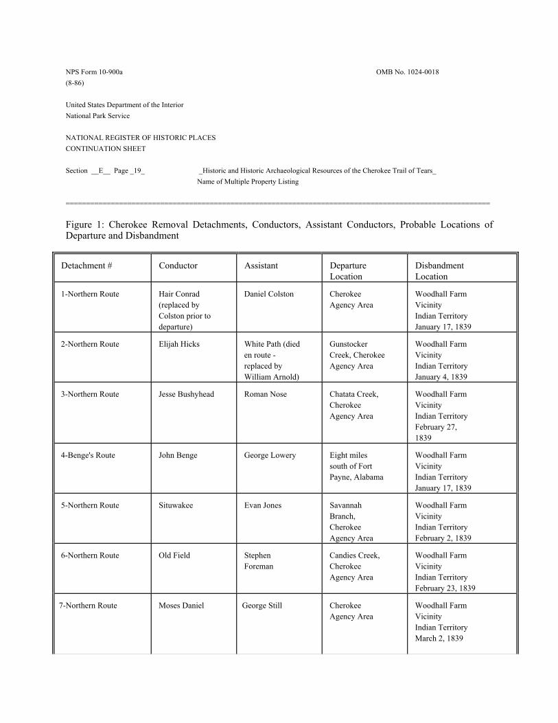
NPS Form 10-900a OMB No. 1024-0018 (8-86) United States Department of the Interior National Park Service NATIONAL REGISTER OF HISTORIC PLACES CONTINUATION SHEET Section __E__ Page _19_ _Historic and Historic Archaeological Resources of the Cherokee Trail of Tears_ Name of Multiple Property Listing ======================================================================================================= Figure 1: Cherokee Removal Detachments, Conductors, Assistant Conductors, Probable Locations of Departure and Disbandment
1-Northern Route Hair Conrad (replaced by Colston prior to departure)
Daniel Colston Cherokee Agency Area
Woodhall Farm Vicinity Indian Territory January 17, 1839
2-Northern Route Elijah Hicks White Path (died en route - replaced by William Arnold)
Gunstocker Creek, Cherokee Agency Area
Woodhall Farm Vicinity Indian Territory January 4, 1839
3-Northern Route Jesse Bushyhead Roman Nose Chatata Creek, Cherokee Agency Area
Woodhall Farm Vicinity Indian Territory February 27, 1839
4-Benge's Route John Benge George Lowery Eight miles south of Fort Payne, Alabama
Woodhall Farm Vicinity Indian Territory January 17, 1839
5-Northern Route Situwakee Evan Jones Savannah Branch, Cherokee Agency Area
Woodhall Farm Vicinity Indian Territory February 2, 1839
6-Northern Route Old Field Stephen Foreman
Candies Creek, Cherokee Agency Area
Woodhall Farm Vicinity Indian Territory February 23, 1839
7-Northern Route
Moses Daniel George Still Cherokee Agency Area
Woodhall Farm Vicinity Indian Territory March 2, 1839
NPS Form 10-900a OMB No. 1024-0018 (8-86) United States Department of the Interior National Park Service NATIONAL REGISTER OF HISTORIC PLACES CONTINUATION SHEET Section __E__ Page _20_ _Historic and Historic Archaeological Resources of the Cherokee Trail of Tears_ Name of Multiple Property Listing =======================================================================================================
8-Northern Route
Choowalooka (replaced by Thomas N. Clark at Smith's Ferry)
J.D. Wofford Cherokee Agency Area
Woodhall Farm Vicinity Indian Territory March 1, 1839
9-Northern Route James Brown ? Ooltewah Creek, near Vann's Plantation
Woodhall Farm Vicinity Indian Territory March 5, 1839
10-Northern Route George Hicks Collins McDonald
Mouse Creek, Cherokee Agency Area
Woodhall Farm Vicinity Indian Territory March 14, 1839
11-Northern Route Richard Taylor Red Watt Adair Near Vann's Plantation
Woodhall Farm Indian Territory March 24, 1839
12-Northern Route Peter Hildebrand James Hildebrand Cherokee Agency Area
Woodhall Farm Indian Territory March 25, 1839
13-Water Route Capt. John Drew John G. Ross Cherokee Agency Area
IllinoisCampground Indian Territory March 18, 1839
14-Bell's Route John Bell Lt. Edward Deas Cherokee Agency Area
Vineyard Post Office, Arkansas (Evansville) January 7, 1839
15-Water Route Lt. Edward Deas Cherokee Agency Area
Fort Coffee, Indian Territory June 20, 1838
16-Water Route Lt. R. Whitely Cherokee Agency Area
Flint Settlement Indian Territory August 5, 1838
17-Water Route Capt. G.S. Drane Cherokee Agency Area
Webbers Plantation Indian Territory September 5, 1838
Sources: Hoig, 99-121; King, 1999, 12-88.
NPS Form 10-900a OMB No. 1024-0018 (8-86) United States Department of the Interior National Park Service NATIONAL REGISTER OF HISTORIC PLACES CONTINUATION SHEET Section __E__ Page _21_ _Historic and Historic Archaeological Resources of the Cherokee Trail of Tears_ Name of Multiple Property Listing =======================================================================================================
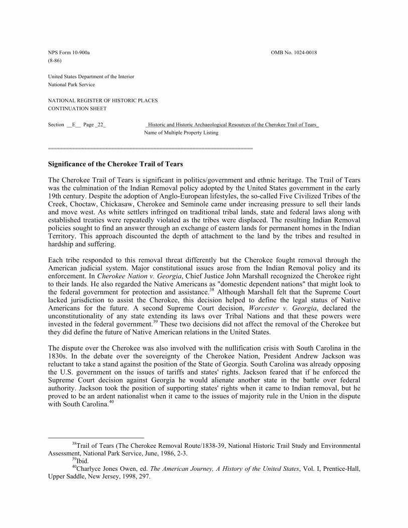
NPS Form 10-900a OMB No. 1024-0018 (8-86) United States Department of the Interior National Park Service NATIONAL REGISTER OF HISTORIC PLACES CONTINUATION SHEET Section __E__ Page _22_ _Historic and Historic Archaeological Resources of the Cherokee Trail of Tears_ Name of Multiple Property Listing ==================================================================== Significance of the Cherokee Trail of Tears The Cherokee Trail of Tears is significant in politics/government and ethnic heritage. The Trail of Tears was the culmination of the Indian Removal policy adopted by the United States government in the early 19th century. Despite the adoption of Anglo-European lifestyles, the so-called Five Civilized Tribes of the Creek, Choctaw, Chickasaw, Cherokee and Seminole came under increasing pressure to sell their lands and move west. As white settlers infringed on traditional tribal lands, state and federal laws along with established treaties were repeatedly violated as the tribes were displaced. The resulting Indian Removal policies sought to find an answer through an exchange of eastern lands for permanent homes in the Indian Territory. This approach discounted the depth of attachment to the land by the tribes and resulted in hardship and suffering. Each tribe responded to this removal threat differently but the Cherokee fought removal through the American judicial system. Major constitutional issues arose from the Indian Removal policy and its enforcement. In Cherokee Nation v. Georgia, Chief Justice John Marshall recognized the Cherokee right to their lands. He also regarded the Native Americans as "domestic dependent nations" that might look to the federal government for protection and assistance.38 Although Marshall felt that the Supreme Court lacked jurisdiction to assist the Cherokee, this decision helped to define the legal status of Native Americans for the future. A second Supreme Court decision, Worcester v. Georgia, declared the unconstitutionality of any state extending its laws over Tribal Nations and that these powers were invested in the federal government.39 These two decisions did not affect the removal of the Cherokee but they did define the future of Native American relations in the United States. The dispute over the Cherokee was also involved with the nullification crisis with South Carolina in the 1830s. In the debate over the sovereignty of the Cherokee Nation, President Andrew Jackson was reluctant to take a stand against the position of the State of Georgia. South Carolina was already opposing the U.S. government on the issues of tariffs and states' rights. Jackson feared that if he enforced the Supreme Court decision against Georgia he would alienate another state in the battle over federal authority. Jackson took the position of supporting states' rights when it came to Indian removal, but he proved to be an ardent nationalist when it came to the issues of majority rule in the Union in the dispute with South Carolina.40
38Trail of Tears (The Cherokee Removal Route/1838-39, National Historic Trail Study and Environmental Assessment, National Park Service, June, 1986, 2-3. 39Ibid. 40Charlyce Jones Owen, ed. The American Journey, A History of the United States, Vol. I, Prentice-Hall, Upper Saddle, New Jersey, 1998, 297.
NPS Form 10-900a OMB No. 1024-0018 (8-86) United States Department of the Interior National Park Service NATIONAL REGISTER OF HISTORIC PLACES CONTINUATION SHEET Section __E__ Page _23_ _Historic and Historic Archaeological Resources of the Cherokee Trail of Tears_ Name of Multiple Property Listing ======================================================================================================= Finally, the Trail of Tears is significant as a seminal event in the history of the Cherokee Nation. The Cherokee were forced to endure the loss of their ancestral homes in the southern Appalachian Mountains and instead begin anew in the totally different environment and landscape of the Indian Territory. Despite terrible hardships and sufferings along poor roads and through a bitter winter, the Cherokee arrived in the Indian Territory with their tribal institutions intact and proceeded to create a new nation. For the purposes of this nomination, the period of significance for the Cherokee Trail of Tears is from January of 1837 to September 6, 1839. While some Cherokee voluntarily settled in the Indian Territory in the early 1830s, formal removal did not occur until after the signing of the Treaty of New Echota in 1835. The first large group of those who signed the New Echota treaty left in January of 1837. Comprised of some 600 Cherokee, this group emigrated west by an overland route. The group was described as well supplied, with numerous wagons loaded with their personal possessions.41 The second organized group of emigrating Cherokee left Ross's Landing in Tennessee on March 3, 1837. This group of 466 Cherokee, traveling on eleven flatboats, was led by Major Ridge, a prominent pro-treaty leader. This group reached Arkansas by the end of the month and landed at Fort Smith. They then took an overland route and settled at Honey Creek in the Indian Territory.42 In early October of 1837, a group of Cherokee led by Lt. B.B. Cannon made an overland journey from the Cherokee Agency area to the Indian Territory. This was the first entirely overland journey made by a large group of Cherokee after the Treaty of New Echota, and this route was followed by eleven of the seventeen detachments which traveled west in 1838. In March of 1839 the last two detachments traveling overland from Tennessee disbanded in the Indian Territory. As the Cherokee began to adjust to their new home, discord continued between the pro- and anti-removal factions. In June 1839, Major Ridge, John Ridge and Elias Boudinot were assassinated for their pro-removal politics. Following the assassinations, the Reverend Jesse Bushyhead and Sequoyah worked to unify the two groups, and on September 6, 1839, a council representing both groups adopted a new constitution and elected John Ross as principal chief.43
41Gilbert, 25. 42Ibid., 28. 43Ibid., 85.
NPS Form 10-900a OMB No. 1024-0018 (8-86) United States Department of the Interior National Park Service NATIONAL REGISTER OF HISTORIC PLACES CONTINUATION SHEET Section __E__ Page _24_ _Historic and Historic Archaeological Resources of the Cherokee Trail of Tears_ Name of Multiple Property Listing ======================================================================================================= Associated Historic Context Buildings, Building Sites, Assembling Points and Removal Routes for the Cherokee Trail of Tears in Alabama, Georgia, North Carolina and Tennessee, 1837-1838 Overview The Trail of Tears was the culminating event of the removal of the Cherokee Nation from the southern Appalachian Mountains in America. Beginning in the 18th century, the Cherokee signed treaty after treaty ceding lands to private speculators and the United States government. Before and after the passage of the Indian Removal Act by Congress in 1830, numerous Cherokee families sold their property and moved west to the Indian Territory (now Oklahoma). In 1832, Benjamin Currey led 626 Cherokee by boat from the Hiwassee River west to the Indian Territory and another group of 457 Cherokee left in 1834.44 With the signing of the Treaty of New Echota in 1835, additional Cherokee felt resisting removal was futile and moved west. These included a group of approximately 600 pro-treaty Cherokee who left New Echota in January of 1837 and an additional 466 Cherokee led by Major Ridge which left from Ross's Landing in March of 1837. Approximately 360 Cherokee led by Lt. B.B. Cannon left the Cherokee Agency near Charleston on October 14, 1837. Cannon marched his group west across the Cumberland Plateau to Nashville and then crossed the Ohio River at Golconda, Illinois. After traveling through southern Illinois, Cannon and his party crossed the Mississippi River at the Hamburg Landing to Bainbridge, Missouri. Cannon's party then traveled to Jackson, Farmington, and Caledonia before stopping for several days on Huzzah Creek in Crawford County due to illness in many families. After a few days, Cannon's group of Cherokee continued southwest through Missouri passing through Springfield and into Arkansas. After going through Fayetteville, the Cannon party entered the Indian Territory and disbanded at Bean’s on the Barren Fork south of present-day Westville, Oklahoma on December 30, 1837. Cannon's journey was an important one because his route was followed by the majority of the Cherokee who would leave the East in 1838. Because of the difficulty of the journey and the deaths which occurred along the way, the Cannon party's physician, Dr. G.S. Townsend, wrote to the Bureau of Indian Affairs urging them to transport the Cherokee by boat rather than by going overland.45 Townsend argued that going by boat to Boonville, Missouri the Cherokee would only have 200 miles of overland travel rather than the 800 miles completed by the Cannon group. Despite this warning no substantial efforts to transport the bulk of the Cherokee via water routes were implemented by the US government.
44Nance, 11. 45Gilbert, 62.
NPS Form 10-900a OMB No. 1024-0018 (8-86) United States Department of the Interior National Park Service NATIONAL REGISTER OF HISTORIC PLACES CONTINUATION SHEET Section __E__ Page _25_ _Historic and Historic Archaeological Resources of the Cherokee Trail of Tears_ Name of Multiple Property Listing ======================================================================================================= The United States War Department began to forcibly roundup and confine the Cherokee people in 1838. General Winfield Scott was in charge of the removal and had a force of over 7,000 troops and state militia to assist in the operation. Scott divided the Cherokee Nation into three military districts and established several military posts throughout the nation. Troops detained the Cherokee at these various posts until officials finalized details of the trip. The Cherokee were then transported to three main emigration depots from which they began their journey. These three emigration depots were the Cherokee Agency at Fort Cass in present-day Charleston, Tennessee, a camp four miles upstream from Ross's Landing in present-day Chattanooga, Tennessee, and a camp south of Fort Payne, Alabama. In his 1999 report on the Cherokee Trail of Tears in which he updates and corrects the National Park Service's 1992 map supplement, historian Duane H. King notes that "With this interpretation, two states which had substantial Cherokee populations at the time of removal, Georgia and North Carolina, have no designation of an historic trail within their boundaries."46 King points out that the true starting points of the Trail of Tears are the individual homes from which thousands of Cherokee were forcibly removed in the initial roundup. King acknowledges the impracticality of several thousand points of origin and suggests that the twenty-seven individual forts used by state militia and Federal troops in 1838 be recognized as starting points, and that the historic roads connecting them to the emigrating depots be acknowledged as parts of the trail.47 This approach, which is utilized for this nomination, recognizes the significance of these properties as assembly locations for the Cherokee, which were a prelude to the actual march west. The bulk of the Cherokee Nation from 1819 to 1838 largely existed in northwestern Georgia. Its boundaries also reached into northeastern Alabama, southeastern Tennessee, and southwestern North Carolina. The Tennessee River served as the nation's northwestern border, and the Chattahoochee River created the southeastern border. Its eight judicial districts established in 1819 were: Amohee, Aquohee, Chatooga, Chickamauga, Coosawatee, Etowah, Hickory Log, and Taquohee.48 Numerous ferries, mills, tanneries, and other industries existed throughout the Cherokee Nation. These include Gunter's Ferry on the Tennessee River near Gunter's Town, Brown's Ferry, Ross's Ferry, and Blythe's Ferry all further north on the Tennessee, and Pathkiller's Ferry located on the Coosa River. Mills included Vann's Mill near Spring Place and the Conasauga River, Brainerd's Mill near Chickamauga, and Glass's Mill on the Tennessee-Georgia border. Schools and missions were located in Creek Path, Will's
46King, 4. 47Ibid., 4-5. 48Ibid., 5.
NPS Form 10-900a OMB No. 1024-0018 (8-86) United States Department of the Interior National Park Service NATIONAL REGISTER OF HISTORIC PLACES CONTINUATION SHEET Section __E__ Page _26_ _Historic and Historic Archaeological Resources of the Cherokee Trail of Tears_ Name of Multiple Property Listing ======================================================================================================= Town, Hawens, Hightower, New Echota, Spring Place, Red Clay, Candy's Creek, Brainerd, Amohee, and other areas. Stores and taverns included Five Killer's Tavern on the Ocoee River just south of Hiwassee, McNair's Store near Red Clay, Vann's Store near Spring Place, Harlan's Tavern north of Coosawatee, McCoy's Tavern near New Echota, Field's Store and McIntosh's Tavern near Fort Cass, and Ross's Store and Brown's Tavern along the Tennessee River.49 Most of these ferries were utilized by the Cherokee during the actual Trail of Tears. Most of the schools, missions, stores, mills, taverns and related properties, while significant for their association with the Cherokee of the early 19th century, will not be directly associated with the Trail of Tears. Other individual properties within the boundaries of the original Cherokee Nation include the homes of various Cherokee leaders such as that of John Ridge in Oothcaloga, Georgia, and that of David Oo-watie located near Calhoun, Georgia. The Oo-watie home, now known as Bray Gardens at Daffodil Farm, is a simple frame dwelling constructed ca. 1796. Oo-watie was the brother of Major Ridge and father to Elias Boudinot and Stand Watie, who were born in the house in 1804 and 1806 respectively.50 Boudinot and Watie were key figures in the pro-treaty faction of the Cherokee people. These and other extant dwellings within the original Cherokee Nation are significant for their associations with individuals notable in the events leading up to the Trail of Tears and its aftermath. General Scott divided the Cherokee Nation into three military districts. The Eastern District consisted of the nation's boundaries in North Carolina, the part of Tennessee that lies north of Gilmer County Georgia, and the counties of Gilmer, Union, and Lumpkin in Georgia. The Western District included the remainder of the nation's land in Tennessee, Dade County in Georgia, and the nation's land in Alabama. The Middle District consisted of the remainder of the Cherokee's land in Georgia. Headquarters for the districts were Ross's Landing in the West, Fort Butler in the East and New Echota in the Middle.51 The twenty-seven military posts established in the Cherokee Nation were: MIDDLE DISTRICT Cedartown, Geogria Rome, Georgia Spring Place, Georgia Fort Gilmer, near Coosawattee, Georgia Fort Cumming, near Lafayette, Georgia Fort Buffington, near Canton, Georgia
NPS Form 10-900a OMB No. 1024-0018 (8-86) United States Department of the Interior National Park Service NATIONAL REGISTER OF HISTORIC PLACES CONTINUATION SHEET Section __E__ Page _27_ _Historic and Historic Archaeological Resources of the Cherokee Trail of Tears_ Name of Multiple Property Listing ======================================================================================================= Fort Wool, near New Echota, Georgia Fort Means, Floyd County, Georgia Fort Chastains, Georgia Fort Sixes, Georgia Fort Campbell, near Scudders, Georgia WEST DISTRICT Fort Likens, Broomtown Valley, Alabama Fort Lovell, near Cedar Bluff, Alabama Fort Payne, near Rawlingsville, Alabama Ross Landing, Tennessee Fort Morrow, Tennessee Fort at Cleveland, Tennessee Fort Foster, Tennessee near Rattlesnake Springs EAST DISTRICT Fort Newnan, near Sanders,Georgia Fort Hetzel, near Ellijay, Georgia Fort Dahlonega, Georgia Fort Butler, North Carolina Fort Hembree, North Carolina Fort Delaney, North Carolina Fort Lindsay, North Carolina Fort on the Nantahala River, North Carolina (Camp Scott) Fort in Cheowee Valley, North Carolina (Fort Montgomery)52 In addition to these forts, Fort Cass at the Cherokee Agency in Charleston was also used as an internment camp. The Cherokee were transferred from these twenty-seven posts to the three principal emigrating depots: the site near Ross's landing, the Cherokee Agency at Fort Cass, and near Fort Payne. In North Carolina, the routes converged at Fort Butler and then headed northwest to Fort Cass. Duane King maps the route from Quallatown to Fort Lindsay, which rested at the northern foot of the Nantaheelee Ridge. The route then followed the Nantaheelee Road in a southwesterly direction through a gap in Long Ridge to where the road intersected the Athens and Franklin Stage Road. Traveling west on the Athens and Franklin Stage Road, the route passes Fort Delaney, where another trail from the north meets the stage road. This trail
52Ibid., 6.
NPS Form 10-900a OMB No. 1024-0018 (8-86) United States Department of the Interior National Park Service NATIONAL REGISTER OF HISTORIC PLACES CONTINUATION SHEET Section _E___ Page _28_ _Historic and Historic Archaeological Resources of the Cherokee Trail of Tears_ Name of Multiple Property Listing ======================================================================================================= descends from the Cheeowah Valley through a gap in Long Ridge. From Fort Delaney, the route continues southwest along the Athens and Franklin Stage Road until it arrives at Fort Butler along the Hiwassee River near the town of Murphy. A direct route also connects Fort Butler with Fort Hembree, which lies to the east.53 The road that connects Fort Lindsay, Fort Delaney, and Fort Butler closely follows the alignment of present day US 19/129. The road that connects Fort Butler and Fort Hembree follows much the same alignment as present day US 64. The site of Andrew Hunter's home is near Fort Butler and is marked on Civil War maps of the area. Hunter was a confidant of both the military and the Cherokee. Lt. William Fenton Mercer Noland, a disbursing agent for the Cherokee removal, notes in his diary that his group stopped for the day at Hunter's place, which he remarks as being approximately six miles below the junction of the Valley River.54 When the Cherokee left Fort Butler they crossed the nearby Hiwassee at a ferry operated by Hunter. The route from Fort Butler to the Cherokee Agency at Fort Cass initially followed the Unicoi Turnpike. This was the primary wagon route connecting Tennessee and North Carolina in this region of the Appalachian Mountains. The Unicoi Turnpike was largely abandoned by the late 19th century and several miles of intact roadbed remain along this route. The route followed the Unicoi Turnpike to Tellico Plains where it turned west and possibly traveled through Athens on its way to Fort Cass. Groups from the Middle District were directed to either a camp four miles north of Ross's Landing near Chattanooga or the Cherokee Agency near Fort Cass. The main route in this district extended north from Fort Means near Adairsville through New Echota and Fort Wool, continuing northward to Dalton, then Varnell's Station, and finally Fort Cass. This route later paralleled the Cleveland and Dalton Railroad line. From Ellijay and Spring Place, groups headed west to Dalton and either traveled north to Charleston or went northwest through Tunnel Hill to Hookers Gap near Ringgold. They then continued on to Rossville where they turned north a short distance to Chattanooga. From Fort Cumming, near Lafayette, Georgia, groups headed north through Fleetown to Rossville and then on to Chattanooga. This route lies east and parallel to Pigeon Mountain and Crawfish Creek.55 In Alabama, the forts of Fort Payne, Fort Likens, and Fort Lovell were built as temporary stockades to house the Cherokee rounded up in northeast Alabama. From these three forts the Cherokee were marched to an emigration depot eight miles south of Fort Payne. The site of this depot in the Western District has never been identified. Duane King suggests that the site might be present-day Lebanon in Big Will's Valley. It is possible, however, that the encampment was located across the ridge in Little Will's
NPS Form 10-900a OMB No. 1024-0018 (8-86) United States Department of the Interior National Park Service NATIONAL REGISTER OF HISTORIC PLACES CONTINUATION SHEET Section __E__ Page _29_ _Historic and Historic Archaeological Resources of the Cherokee Trail of Tears_ Name of Multiple Property Listing ======================================================================================================= Valley near Portersville or Dog Town.56 Seventeen detachments left from the three main emigrating depots, between June 6th and December 5th of 1838. The journey took place over various land and water routes and averaged over 1,000 miles. The first three detachments departed from Ross's Landing in June of 1838. They were accompanied by military escorts and were largely composed of "uncooperative" Georgia Cherokee who were strongly opposed to the removal.57 Two of these three groups left Ross's Landing and traveled west by steamboat. The third group traveled overland from Ross's Landing to Waterloo, Alabama, and from that point traveled by river to the Indian Territory. Only one other detachment received a military escort - that conducted by John Bell who led the "pro-treaty" Cherokee. The remainder of the Cherokee were transferred under the supervision of Cherokee Chief John Ross, who had made an arrangement with General Scott to allow the Cherokee to conduct the removal themselves. Scott also agreed to delay the removal until the fall and improved weather conditions.58 The majority of the Cherokee were concentrated at the Cherokee Agency area. Several camps were located in this general vicinity, which covered a four mile by twelve mile area along the Hiwassee River extending from the Cherokee Agency at Calhoun to Fort Cass, which was near present day Charleston. Camps in the area included those located on Savannah Branch, Gunstocker Spring, Candies Creek, and Mouse Creek. Approximately 2,000 Cherokee were located at Camp Ross, which was situated about thirteen miles south of Fort Cass, where the town of Cleveland is today. In Cleveland at Fort Hill Cemetery is a site of a Cherokee internment camp (40BY32).59 Camps were also organized around four miles above Ross's Landing in present-day Chattanooga. The camp in Alabama was located approximately eight miles south of Fort Payne and contained around 1,000 Cherokee. Between October and December of 1838, fourteen detachments of Cherokee left the emigrating depots for the Indian Territory. All but one of these, the Bell detachment, were under the supervision of John Ross. One party under Ross, which consisted mainly of elderly and infirm individuals, traveled by river; the remainder made the journey overland. There were three primary overland routes. Eleven of the detachments followed the route taken by the Cannon party in 1837 now known as the Northern Route. Variations of this route were made in southeast Tennessee by the Taylor and Brown detachments, and in central Missouri by the Hildebrand detachment. The second route was that taken by John Benge's detachment, which left from the camp south of Fort Payne, Alabama and traveled through Tennessee,
56Ibid., p.11. 57Ibid., 12. 58Nance, "The Trail of Tears in Tennessee,” 14-15. 59Ibid., 23.
NPS Form 10-900a OMB No. 1024-0018 (8-86) United States Department of the Interior National Park Service NATIONAL REGISTER OF HISTORIC PLACES CONTINUATION SHEET Section __E__ Page _30_ _Historic and Historic Archaeological Resources of the Cherokee Trail of Tears_ Name of Multiple Property Listing ======================================================================================================= Kentucky, southeast Missouri, and Arkansas. John Bell's detachment was the third overland route, which led across southern Tennessee through Memphis and into Arkansas.60 Buildings, Building Sites, Assembly Points and Removal Routes in Alabama No buildings directly associated with Cherokee leaders important in the history of the Trail of Tears are known to exist in Alabama. Three forts were built in Alabama to serve as temporary concentration camps for the Cherokee: Fort Payne, Fort Likens, and Fort Lovell. Fort Payne was the northernmost fort in Alabama and it was built near the small town of Rawlingsville. Named for its first commander, Capt. John G. Payne, this temporary fort was built in early April of 1838. It housed Cherokee rounded up by the US Army in Alabama, Tennessee and Georgia. Following the removal of the Cherokee, the fort was demolished and its site is now occupied by a modern governmental office building in downtown Fort Payne. Fort Likens was a removal fort established in Broomtown Valley, Alabama. It was built near Barry Springs because of this reliable water source and its close proximity to the Cherokee settlements of Turkeytown, Wills Town, Broomtown, and Haweis Mission. The stockade was circular and held up to 500 families.61 No archaeological investigations have occurred at the Barry Springs site but the remains of Fort Likens are likely nearby. Barry Springs is recognized as associated with this temporary fort and is potentially eligible for the National Register. The other removal fort in Alabama was Fort Lovell, near Cedar Bluff. The site was impacted by the impoundment of the Coosa River for Weiss Lake during the 20th century. The fort's site is believed to be in the vicinity of Williamson Island in the lake. Originally called Fort Armstrong, the fort was constructed in 1813 during the Creek War and was built to protect the nearby Cherokee settlement of Turkeytown, which was being threatened by hostile Creeks.62 The fort was used for several weeks in 1838 to house Cherokee from the military roundup. The exact site of this fort is unknown and no archaeological investigations have occurred for this property. The site of the emigrating depot used by John Benge and his detachment south of Fort Payne has never been identified. It is believed to be approximately eight miles south of Fort Payne. Historian Duane King suggests that the site might be present day Lebanon in Big Will's Valley. It is possible, however, that the
60King, 12-20; Nance 16-17. 61Vicki Rozema, Footsteps of the Cherokees: A Guide to the Eastern Homelands of the Cherokee Nation. (Winston-Salem, NC: John F. Blair, Publixher, 2000), 352. 62Ibid., 353-354.
NPS Form 10-900a OMB No. 1024-0018 (8-86) United States Department of the Interior National Park Service NATIONAL REGISTER OF HISTORIC PLACES CONTINUATION SHEET Section __E__ Page _31_ _Historic and Historic Archaeological Resources of the Cherokee Trail of Tears_ Name of Multiple Property Listing ======================================================================================================= encampment was located across the ridge in Little Will's Valley near Portersville or Dog Town.63 From this depot, John Benge led some 1,000 Cherokee north to Gunter's Landing and then on an independent route through Tennessee, Kentucky, Missouri, and Arkansas to the Indian Territory. Buildings, Building Sites, Assembly Points, and Removal Routes in Georgia Of all the states in the Southeast, Georgia contained the largest number of Cherokee and land mass of the Cherokee Nation. Because of its prominence, the state was home to many of the Cherokee leaders leading up to the Treaty of New Echota and the Trail of Tears. The majority of the dwellings and buildings the Cherokee left behind in Georgia in 1838 are no longer extant. However, a number of dwellings remain standing which are associated with Cherokee leaders prominent for their association with the removal period. Several of these are well known historic sites and are listed on the National Register of Historic Places. The home of Cherokee Chief John Ross is located in Rossville, Georgia. Ross became a prominent farmer and leader of the Cherokee Nation in the 1820s, and was elected principal chief in 1828. The two-story log dwelling was built in 1797 by Ross's grandfather, John McDonald. As a boy, Ross lived nearby in a cabin built by his father, Daniel Ross. At around age 18, John Ross moved to his grandfather's house, and it remained his home over the next twenty years. In 1833, Georgia authorities sold his property at lottery and Ross was forced to move to Tennessee. Today, the John Ross House Association maintains the dwelling, which is open to the public during the summer months.64 The John Ross House was listed on the National Register of Historic Places in 1973 and is a National Historic Landmark. During the late 20th century, the dwelling was moved a short distance from its original location.This move took place prior to its listing on the National Register and its subsequent designation as a National Historic Landmark. In Rome, Georgia, is the home of prominent Cherokee leader The Ridge, or Major Ridge, who was a key figure in the signing of the New Echota Treaty. Originally built in 1794 of log construction, the house was expanded in the early 1800s into a stately two-story, frame dwelling. The Ridge bought the log dwelling on the Oostanaula River in the early 1800s and developed the property into a successful plantation. His son, John Ridge, built a home approximately six miles north of the Ridge plantation in Oothcaloga, Georgia. The home of David Oo-watie is located near Calhoun, Georgia. The Oo-watie home, now known as Bray Gardens and Daffodil Farm, is a simple frame dwelling constructed ca. 1796. Oo-watie was the brother of Major Ridge and father to Elias Boudinot and Stand Watie, who were born in the house in 1804 and 1806 respectively. Boudinot and Watie were key figures in the pro-treaty faction of
63King, 11. 64Rozema, 71.
NPS Form 10-900a OMB No. 1024-0018 (8-86) United States Department of the Interior National Park Service NATIONAL REGISTER OF HISTORIC PLACES CONTINUATION SHEET Section __E__ Page _32_ _Historic and Historic Archaeological Resources of the Cherokee Trail of Tears_ Name of Multiple Property Listing ======================================================================================================= the Cherokee people.65 Tensions remained high between the pro-removal Cherokee and those in the Ross faction after they settled in the West. The Ridge, his son John, and Elias Boudinot, who was Ridge's nephew, were murdered on June 22, 1839, for their role in signing the New Echota Treaty. The Ridge House is a National Historic Landmark and is listed on the National Register of Historic Places. It is owned by the Chieftains Museum Association, which operates a museum in the building.66 Also in Georgia is the home of prominent Cherokee James Vann. During the early 1800s, the Vann family was one of the most prosperous in the Cherokee Nation. James Vann built a two-story brick Federal style mansion at Spring Place, Georgia, in 1804 that reflected his wealth and status. After his death in 1809, his son Joseph inherited the property. In 1835, Georgia soldiers evicted the Vanns from their Spring Place property, and the family temporarily settled on a farm in Tennessee until the 1838 removal. The Vann House in Spring Place is a State Historic Site and is listed on the National Register of Historic Places.67 New Echota, Georgia, is perhaps the most well known Cherokee site in Georgia. It was in this Cherokee town that the New Echota Treaty, which led to the forced removal of the Cherokee, was signed in 1835. In 1828, Elias Boudinot printed the first issues of the Cherokee Phoenix in New Echota. After the Cherokee were removed from the area, the town stood neglected for years. In the 1950s, area residents restored Rev. Samuel A. Worcester's house and New Echota became a state historic site. The New Echota site is listed on the National Register and is a National Historic Landmark. The property contains replicas of the Cherokee Phoenix print shop, the Cherokee Supreme Court House, and the Cherokee Council House. The site also contains three buildings that are original Cherokee structures but which are not original to the site, including the ca. 1805 James Vann Tavern. The 1828 house of Rev. Worcester is the only original building on the property. This dwelling was a Presbyterian Mission Station as well as the Worcester family home. In a pasture behind the Worcester House is the site of Fort Wool, one of the removal forts during the 1838 removal.68 The locations of the forts and assembly locations of the Cherokee in Georgia are associated with the transportation network of the period. A number of roads connected the major Cherokee communities in north Georgia and the major crossroads and communities were selected as fort sites. One of the most important roads through the Cherokee Nation was the Federal Road. In 1805, the Cherokee agreed to allow the United States to construct a road across their land. The road, known as the Federal Road, followed existing Indian trading paths that connected Augusta, Georgia to Lookout Mountain, Tennessee.
NPS Form 10-900a OMB No. 1024-0018 (8-86) United States Department of the Interior National Park Service NATIONAL REGISTER OF HISTORIC PLACES CONTINUATION SHEET Section __E__ Page _33_ _Historic and Historic Archaeological Resources of the Cherokee Trail of Tears_ Name of Multiple Property Listing ======================================================================================================= Other trails leading to Nashville and northern Alabama also connected to this road. The Federal Road was twenty-four feet wide and ran northwest from Athens, Georgia, to what is now Lake Lanier and then on to various Cherokee villages along Talking Rock Creek. The Federal Road benefited the Cherokee, who built taverns, inns, stores, and toll ferries along the route. As the principal postal route in the region, the Federal Road aided the delivery of the Cherokee Phoenix.69 Ultimately, however, the Federal Road assisted in the removal of the Cherokee in Georgia. The route made the area more accessible to white settlers, who gradually took the native lands. Georgia Cherokee also traveled the Federal Road on their way to Ross's Landing and the Cherokee Agency in Tennessee, where they began their journey on the Trail of Tears. Forks in the Federal Road occurred near the town of Ramhurst, Georgia. One branch led to Eton and then toward Knoxville, while the other headed to Spring Place and eventually Nashville. Today, the intersection of old US 411 and US 76/GA 282 marks the site of the forks of the Federal Road. A section of the Federal Road is preserved in Reflection Riding, a motor-trail loop through the botanical garden of the Chattanooga Nature Center near Lookout Mountain.70 Ten stockades and open stations were established in Georgia as bases for the militia prior to the removal of the Cherokee people in the 1830s. Fort Buffington was located east of the town of Canton, Georgia, in what is now the town of Buffington. An historical marker marks the site of the fort, which is now occupied by a local school. Fort Gilmer was constructed in 1838 along the Federal Road and near the Cherokee town of Coosawatte. The site of the fort is near the present-day town of Carters, Georgia. General Winfield Scott used the fort as a temporary headquarters as the removal was initiated. Fort Cumming was built in what is now the town of LaFayette in 1836. It was named for David B. Cumming, a Methodist missionary who traveled with the Cherokee to Oklahoma. The site of Fort Cumming is located in the Big Spring area of LaFayette, and an historical marker notes the site. Other Georgia removal forts and the vicinity of their present-day locations are: Fort Hoskins (Spring Place), Fort Wool (New Echota), Fort Means (Kingston), Fort Campbell (Scudders), Fort Newnan (Blaine), Fort Hetzel (Ellijay), and Fort Embry (Dahlonega).71 Modern construction and development have consumed most of the sites and archaeological investigations have been limited. In 2002, the National Park Service provided a grant to the Georgia State Historic Preservation Office to conduct archaeological studies of the fort sites and more definitive information may be provided through this effort.72
69Rozema, 319-321. 70Ibid., 85-86, 319-321. 71Ibid., 312-313, 319-320, 326-327. 72Christine Van Voorhies, Archaeology Outreach Specialist, Georgia Historic Preservation Division, Personal Interview, July 24, 2002.
NPS Form 10-900a OMB No. 1024-0018 (8-86) United States Department of the Interior National Park Service NATIONAL REGISTER OF HISTORIC PLACES CONTINUATION SHEET Section __E__ Page _34_ _Historic and Historic Archaeological Resources of the Cherokee Trail of Tears_ Name of Multiple Property Listing ======================================================================================================= The route of the Trail of Tears in Georgia consists of the roads the Cherokee traveled from the various forts to the principal emigrating depots. Groups from the Middle Military District, which was comprised of Georgia territory, were directed to either the depot near Ross's Landing or the Cherokee Agency at Fort Cass. The main route in this district goes north from Fort Means near Adairsville through New Echota and Fort Wool, continuing northward to Dalton, then Varnell's Station, and finally Fort Cass. From Ellijay and Spring Place, groups headed west to Dalton and either traveled north to Charleston or went northwest through Tunnel Hill to Hookers Gap near Ringgold. They then continued on to Rossville where they turned north a short distance to Chattanooga. From Fort Cumming, near Lafayette, Georgia, groups headed north through Fleetown to Rossville and then on to Chattanooga. This route lies east and parallel to Pigeon Mountain and Crawfish Creek.73 Buildings, Building Sites, Assembly Points, and Removal Routes in North Carolina A portion of the original Cherokee Nation covered parts of southwestern North Carolina until 1835. Also in North Carolina is the Qualla Boundary, the main home of the Eastern Cherokee, located on several hundred acres on the Oconaluftee River. In an 1819 treaty, approximately forty-nine Cherokee families severed their ties to the Cherokee Nation and agreed to become citizens of the United States. In exchange for Cherokee lands, the families were to receive 640-acre reservations. However, the State of North Carolina sold their reservations and gave the Cherokee cash in return. Some rejoined the Cherokee Nation, while others settled in a village along the Oconaluftee River. First named Indiantown, the village was later renamed Quallatown.74 The Eastern Band of Cherokee continue to reside in this reservation area of North Carolina. Six military posts within North Carolina served as assembly locations for the Cherokee prior to their removal to the Cherokee Agency in Tennessee. These posts were Fort Butler, Fort Delaney, Fort Hembree, Fort Montgomery, Fort Lindsay, and Camp Scott. Fort Butler was located opposite the mouth of the Konchete or Valley River on the south bank of the Hiwassee River. The site is near the present town of Murphy. In a small park by the river is a historical marker that references the history of the fort.75 Fort Hembree was situated approximately sixteen miles east of Fort Butler on the south bank of the Hiwassee. A number of Cherokee villages existed in this area, which made it a strategic location for the fort. Tusquitee and Tuskeegee were among the Cherokee towns in the vicinity along with Shooting Creek and Noocoochy towns, and Spikebucktown.
NPS Form 10-900a OMB No. 1024-0018 (8-86) United States Department of the Interior National Park Service NATIONAL REGISTER OF HISTORIC PLACES CONTINUATION SHEET Section __E__ Page _35_ _Historic and Historic Archaeological Resources of the Cherokee Trail of Tears_ Name of Multiple Property Listing ======================================================================================================= The site of Fort Hembree is now located in the town of Hayesville. The location is several blocks from the courthouse and a historical marker indicates the fort's site.76 Fort Delaney was located in present-day Andrews and Fort Montgomery in present-day Robbinsville. The site of Fort Lindsay was at the confluence of the Nantahala and Little Tennessee Rivers which is now under Fontana Lake. Camp Scott was located on the Nantahala River between present-day Andrews and Franklin. In order to get to the fort sites the Cherokee were marched along the various existing road networks connecting the principal Cherokee villages. For the Cherokee in the vicinity of Quallatown, they were marched to Fort Lindsay, which was located near Nantaheelee Ridge. The route then followed the Nantaheelee Road in a southwesterly direction through a gap in Long Ridge to where the road intersected the Athens and Franklin Stage Road. Traveling west on the Athens and Franklin Stage Road, the route led to the Cherokee village of Valleytown (now Andrews).77 Another important route was the trail connecting the Cherokee villages of Cheoah (present-day Robbinsville) and Valleytown. At the time of the Cherokee removal, the U.S. military built Fort Montgomery at Cheoah and Fort Delaney at Valleytown. In order to transfer the Cherokee and their belongings, U.S. soldiers improved the trail over the Snowbird Mountains into a wagon road.78 This road, known as the Pile Ridge-Long Creek Trail, was the only road constructed for the purpose of evacuating the Cherokee in the late 1830s. The Cherokee were led from Fort Montgomery over what became known as Tatham Gap to Fort Delaney. This trail remained a primary access route over the Snowbird Mountains throughout the 19th century. In the late 1800s, the Tatham Gap Road was constructed to replace the old military route, however, local residents continued to use the old military road until the 1930s.79 Situated in a wooded mountainous area, the Pile Ridge-Long Creek Trail remains largely intact despite its decades of nonuse. The trail both parallels and repeatedly crosses the existing Tatham Gap Road which is now an improved and gravelled Forest Service Road. Much of the Pile Ridge-Long Creek Trail retains integrity from the Cherokee removal period and meets the registration requirements set forth in this nomination. From Fort Delaney, the Cherokee continued travelling southwest along the Athens and Franklin Stage Road until they reached Fort Butler along the Hiwassee River near the present-day town of Murphy. A direct route also connects Fort Butler with Fort Hembree, which lies to the east.80
76Ibid., 253-254. 77King, map T-26. 78Brett H. Riggs, "Removal Period (1835-1838) Cultural Resources in the Proposed TIP Project A-9 Highway Corridor: Historical and Physical Evidence" (submitted to North Carolina Department of Transportation, Planning and Environmental Branch, Raleigh, NC, February 9, 1998), 18-21. 79Ibid., 24. 80King, Map T-26.
NPS Form 10-900a OMB No. 1024-0018 (8-86) United States Department of the Interior National Park Service NATIONAL REGISTER OF HISTORIC PLACES CONTINUATION SHEET Section ___E_ Page _36_ _Historic and Historic Archaeological Resources of the Cherokee Trail of Tears_ Name of Multiple Property Listing ======================================================================================================= The road that connects Fort Lindsay, Fort Delaney, and Fort Butler closely follows the alignment of present day US 19/129. The road that connects Fort Butler and Fort Hembree follows much the same alignment as present day US 64. Fort Butler served as the primary assembly point for the North Carolina Cherokee prior to their departure on the Unicoi Turnpike to the emigration depot at Fort Cass. The Cherokee and their military escorts left Fort Butler and crossed the nearby ferry over the Hiwassee River operated by Archibald R.S. Hunter. Hunter established a ferry on the banks of the Hiwassee River in the 1820s, and the ferry became the major crossing of the river in this section of North Carolina. Several major roads connected at this point including the Unicoi Turnpike. Hunter took advantage of this location to not only operate his ferry but also to build and run a general store. The North Carolina Cherokee used Hunter's Ferry as they were led across the Hiwassee and north along the Unicoi Turnpike. The ferry site retains integrity and meets the registration requirements set forth in this nomination. Initial research on the route used by the Cherokee after Fort Butler suggested that they went west through Turtletown (Sulegooghee) and Hiwassee Gap into Tennessee. However, recent research by North Carolina archaeologist Brett Riggs and others indicates that the Cherokee instead used the Unicoi Turnpike to march northwest across the mountains into Tennessee. Originally a 17th century Native American trail, this route was improved in 1813 by the Unicoi Turnpike Company. This company widened the trail to a twelve-foot wide wagon road across the Cherokee Nation from the Tugaloo River in Georgia to the Little Tennessee River in Tennessee. The Unicoi Turnpike was a direct route north through the Unicoi Gap and North Carolina Cherokee would have marched on the Unicoi Turnpike to Tellico Plains. They would have then turned left off the turnpike and headed west possibly traveling through Athens on their way to the Cherokee Agency established at Fort Cass in Charleston, Tennessee. The Unicoi Turnpike was used into the early 20th century when most sections were gradually abandoned as more modern roads were built. Many sections of this historic roadbed remain intact from Murphy to Unicoi Gap and meet registration requirements for listing on the National Register. Another site associated with the Trail of Tears in North Carolina is the grave of Cherokee leader Junaluska. Junaluska was a prominent leader who traveled to Washington and met with President Jackson and members of Congress to protest the Indian Removal policy. He was among the Cherokee in North Carolina who were forced from their homes in 1838. His home was a log dwelling between Aquone and Valleytown on what is now known as Junaluska Creek. After surviving the Trail of Tears, Junaluska returned to North Carolina in 1843 to try and reclaim his land. His dwelling had been dismantled and moved, but Junaluska eventually succeeded in getting lands granted to him near Robbinsville in recognition of his service during the Creek War. He died in 1858, and the graves of Junaluska and his wife Nicie are located on a hillside in Robbinsville.81
81Rozema, 238-239, 231.
NPS Form 10-900a OMB No. 1024-0018 (8-86) United States Department of the Interior National Park Service NATIONAL REGISTER OF HISTORIC PLACES CONTINUATION SHEET Section __E__ Page _37_ _Historic and Historic Archaeological Resources of the Cherokee Trail of Tears_ Name of Multiple Property Listing ======================================================================================================= This gravesite meets the criteria of the National Register. Buildings, Building Sites, Assembly Points, and Removal Routes in Tennessee Tennessee contains the greatest lengths of the various Trail of Tears routes, and there are several known sites associated with the Trail of Tears in the state. A portion of the eastern part of the state was within the boundaries of the original Cherokee Nation, and the primary internment camps and emigrating depots for the Trail of Tears were located in East Tennessee. The official U.S. Cherokee Agency office and Fort Cass were established near the town of Charleston, south of the Hiwassee River. The majority of Cherokee internment camps were concentrated in this area, which covered a four mile by twelve mile area along the Hiwassee River and extending south toward the site of present-day Cleveland. The Cherokee Agency was located just south of the Hiwassee River at the present-day site of Charleston. The Cherokee Agency was the federal government's office which dealt with the leadership of the Cherokee Nation. Established at this location in 1821, this was the third and final location of the Cherokee Agency on the Hiwassee.82 Just west of the Cherokee Agency office was Fort Cass, which served as one of General Winfield Scott's headquarters during the 1838 removal. Here the U.S. Army detained thousands of Cherokee in open camps. Located on the site of Fort Cass is the Henegar House, home of Captain H.B. Henegar, who worked with John Ross and accompanied the Cherokee on their journey west. Following the Trail of Tears, Henegar returned to Tennessee and built a two-story brick dwelling on the former Fort Cass site. The Henegar House remains extant and stands where the Fort Cass barracks were located.83 It was listed on the National Register in 1976. A few blocks south of the Henegar House is the former home of Lewis Ross, brother and business partner of Cherokee chief John Ross. Lewis Ross came to the area in 1821 and operated a trading post and ferry in Charleston. Ross was a good businessman and became quite wealthy. His home is a large two-story frame dwelling that has been remodeled several times since the Ross ownership. When finally forced to move west, Ross and his family traveled by steamboat rather than by foot. Once in the Indian Territory, he continued his business interests and was worth a reported one million dollars by the early 1860s.84 The Lewis Ross House was remodeled and enlarged extensively in the late 19th century, and no longer possesses integrity of its early 19th century construction and period of ownership by Lewis Ross. The majority of the Cherokee internment camps were concentrated at the Cherokee Agency area. Several camps were located in this general vicinity, which covered a four mile by twelve mile area along the Hiwassee River and extending south. These camps were located on Savannah Branch, Gunstocker Spring,
NPS Form 10-900a OMB No. 1024-0018 (8-86) United States Department of the Interior National Park Service NATIONAL REGISTER OF HISTORIC PLACES CONTINUATION SHEET Section __E__ Page _38_ _Historic and Historic Archaeological Resources of the Cherokee Trail of Tears_ Name of Multiple Property Listing ======================================================================================================= Candies Creek, and Mouse Creek. Camp Ross, which held about 2,000 Cherokee, was situated approximately thirteen miles south of Fort Cass, where the town of Cleveland is today. In Cleveland at Fort Hill Cemetery is a site of a Cherokee internment camp (40BY32).85 The last capital of the Cherokee Nation in the east, known as the Red Clay Council Ground, is located approximately thirteen miles south of Cleveland, Tennessee, just across the state line from Red Clay, Georgia. The Cherokee Nation moved its meeting place from Georgia to Tennessee in 1832 as Georgia legislatures increasingly enacted restrictive laws against the Cherokee people. The Red Clay Council Grounds in Tennessee became the center of the Cherokee Nation's national legislative assembly and was the site of many important meetings prior to their forced removal. At the Cherokee Council in October of 1835, Reverend John F. Schermerhorn, a Baptist minister appointed by President Andrew Jackson to negotiate a voluntary removal treaty with the Cherokee, addressed the council. Chief John Ross, Elias Boudinot, Major Ridge and John Ridge were among the prominent Cherokee in attendance. The assembly of several thousand Native Americans overwhelmingly rejected the proposal.86 Two months later Schermerhorn met with a small group in favor of the removal at New Echota, Georgia, who signed the treaty of New Echota. This document was used to justify the forced removal of the Cherokee from their native lands. In September of 1836, the Cherokee Council again met at the Red Clay Council Grounds to discuss the New Echota Treaty. Chief John Ross presided and over 3,000 Cherokee were in attendance, including representatives from the pro-treaty faction. Brigadier General John E. Wool, who commanded the troops engaged in the removal, observed the meeting, and John Mason, Jr., a special agent of the United States, addressed the crowd. Mason's explanation of the treaty was considered by most Cherokee in attendance to be inadequate and full of false promises. The Cherokee unanimously voted to reject the New Echota Treaty. Those who had signed the treaty refrained from voting in fear of retaliation.87 Because of its historical significance the Red Clay Council Ground was acquired by the state of Tennessee and is now a state park. The Red Clay Council Ground site consists of 150 acres in Bradley County, Tennessee. The property was listed on the National Register of Historic Places in 1972, and the park includes a museum and outdoor replicas of an 1830s Cherokee Council House, sleeping huts, and a farmstead. In April of 1984, the Cherokee Council returned to Red Clay. Considering the site sacred ground, the Cherokee placed an eternal flame on the site.88 85Nance, "The Trail of Tears in Tennessee," 14-15. 86James F. Corn, National Register of Historic Places Nomination Form, "Red Clay Council Grounds," April 5, 1972. 87Ibid. 88Ibid.; Lois I. Osborne, "Red Clay State Historic Park," in The Tennessee Encyclopedia of History and Culture, Carroll Van West, ed. (Nashville, TN: Rutledge Hill Press, 1998), 781-782.
NPS Form 10-900a OMB No. 1024-0018 (8-86) United States Department of the Interior National Park Service NATIONAL REGISTER OF HISTORIC PLACES CONTINUATION SHEET Section __E__ Page _39_ _Historic and Historic Archaeological Resources of the Cherokee Trail of Tears_ Name of Multiple Property Listing ======================================================================================================= Approximately five miles northeast of Cleveland is Rattlesnake Springs, the site of the last council of the Cherokee in 1838. Thousands of Cherokee gathered at Rattlesnake Springs for a last hasty council meeting prior to their forced departure west. At this meeting, tribal officials agreed to continue their government and constitution in their new land. Military camps established near Rattlesnake Springs include Camp Foster and Camp Worth. Conditions at the camps were inhumane with little shelter or comfort provided. An estimated 200 Cherokee died at the springs before the removal began.89 Rattlesnake Springs was listed on the National Register of Historic Places in 1973. The forty-acre property consists of farm land and pasture in Dry Valley north of Cleveland. Also near Cleveland, Tennessee, is the home of Hair Conrad, a Cherokee native who led one of the John Ross-affiliated detachments on the Trail of Tears. Conrad also played an important role in the protest against the Treaty of New Echota. He served as a delegate to the Cherokee Constitutional convention in 1827 and traveled to Washington in 1833 to protest the actions of Georgia authorities against the Cherokee. When the Cherokee were forced into removal, Hair Conrad was selected to lead the first detachment from Rattlesnake Springs, Tennessee.90 Hair Conrad's house is a one-and-one-half story, single pen, log dwelling constructed ca. 1804. It is located on Blythewood Road near Cleveland, Tennessee. The house was listed on the National Register of Historic Places for its historical and architectural significance in 1976.91 The homesite of prominent Cherokee Reverend Jesse Bushyhead (1804-1844) is also located in Cleveland, Tennessee. Bushyhead led the third Cherokee detachment to embark on the Trail of Tears. As a minister he translated worship services at the Red Clay council meetings from English to Cherokee. During the summer of 1838, he conducted services in the removal camps. After leading a group over the Trail of Tears, Bushyhead was appointed chief justice of the Cherokee Nation, a position he held until his death in 1844. His son later became the principal chief of the Cherokee from 1879 to 1891. The Cleveland High and Middle School complex now occupy the site of Bushyhead's homesite and no integrity of the site remains. A homesite of Cherokee Chief John Ross is thought to be in the Flint Springs area. Ross moved to this vicinity near Red Clay around 1832 to be near the council grounds. A replica of his cabin is next to Flint Springs not far from Red Clay State Park. Some disagree with this location and think that Ross lived in 89Benjamin Levy, National Register of Historic Places Nomination Form, "Rattlesnake Springs," February 23, 1973; Steve Rodgers, "Rattlesnake Springs," in The Tennessee Encyclopedia of History and Culture, Carroll Van West, ed. (Nashville, TN: Rutledge Hill Press, 1998), 776-777. 90George F. Fielder, National Register Nomination Form, "Hair Conrad Cabin," March 1976, Section 8, p. 1. 91Ibid., Section 7, p. 1.
NPS Form 10-900a OMB No. 1024-0018 (8-86) United States Department of the Interior National Park Service NATIONAL REGISTER OF HISTORIC PLACES CONTINUATION SHEET Section __E__ Page _40_ _Historic and Historic Archaeological Resources of the Cherokee Trail of Tears_ Name of Multiple Property Listing ======================================================================================================= what is now the community of Red Hill.92 This cabin replica is commemorative in its design, and does not meet registration requirements set forth in this nomination. Spring Frog Cabin located in the Elise Chapin Wildlife Sanctuary of Audubon Acres is another Cherokee homesite. Tooan Tuh, or Spring Frog, was a Cherokee chief who lived in the area of Chattanooga prior to the Cherokee removal. The two-story log dwelling in Audubon Acres is named for Spring Frog but the real owner of the property was most likely Drowning Bear.93 Spring Frog Cabin was listed on the National Register of Historic Places as part of Audubon Acres in 1982. The two emigration depots in Tennessee were the primary assembly points for the thousands of Cherokee who journeyed west. The largest concentration of Cherokee were at the Cherokee Agency located on the south side of the Hiwassee River and encompassing some 48 square miles. Within this area the various detachments of the Cherokee were formed and they camped in this vicinity from June to late September, 1838. Conditions at these camps were poor and many succumbed to disease and exposure. The Rattlesnake Springs area is the only campsite within the depot area which is listed on the National Register. Many other sections of this depot area, especially the river bend east of Charleston, are potentially eligible for the National Register as campsites of the Cherokee during the summer and fall of 1838. The second emigration depot was established four miles northeast of Ross's Landing in present-day Chattanooga. This site served as the depature point for the Deas, Whiteley and Drane detachments in June, 1838. Most members of the detachments led by Richard Taylor and James Brown also camped here during the summer of 1838. This site, near South Chickamauga Creek is now an industrial area of the city. In mid-September, these two detachments moved to a new campsite eight miles northeast of Ross's Landing at Vann's Plantation. After Joseph Vann was expelled from his home in Georgia in 1834, he established a new plantation at Wolftever Creek in present-day Hamilton County, Tennessee. In 1835, this plantation had a mill, a ferry boat, and thirty-five houses.94 A large section of Vann's Plantation is now under Chickamauga Lake and the remainder of the site is composed of residential subdivisions.
92Ibid., 112. 93Ibid., 67-69. 94Rozema, 96.
NPS Form 10-900a OMB No. 1024-0018 (8-86) United States Department of the Interior National Park Service NATIONAL REGISTER OF HISTORIC PLACES CONTINUATION SHEET Section __E__ Page _41_ _Historic and Historic Archaeological Resources of the Cherokee Trail of Tears_ Name of Multiple Property Listing ======================================================================================================= Associated Historic Context The Northern Route of the Cherokee Trail of Tears in Tennessee, Kentucky, Illinois, Missouri, Arkansas and Oklahoma, 1838-1839 Overview Eleven of the thirteen detachments comprising some 11,500 Cherokee, traveled overland following what is known as the Northern Route (Map #1). Nine of the eleven detachments that took this route left from camps in the vicinity of the Cherokee Agency, near Fort Cass and Camp Ross. Two detachments, those conducted by Richard Taylor and James Brown, left from camps upstream from Ross's Landing, near present day Chattanooga. This variation of the Northern Route is known as the Taylor Route. Another variation of the northern route is the Hildebrand Route, taken by the detachment conducted by Peter Hildebrand. This route differs from the Northern Route in Missouri. The general Northern Route will be outlined first, then the Taylor and Hildebrand Routes will be discussed. The detachments left the Cherokee Agency over a period of two months in the Fall of 1838. The first detachment under Hair Conrad (replaced by Daniel Colston) left on August 28th. The last detachment to leave that was traveling overland was that of Peter Hildebrand which departed the Cherokee Agency the first week of November. By mid-November the detachments were strung out along two hundred miles of road in Kentucky and Tennessee. Because of the difficulties and delays in crossing the Mississippi River, many of the detachments were bunched together in Illinois during December and January. Continuing through Missouri and Arkansas, the last of the Cherokee detachments along the Northern Route completed their journey to Oklahoma by mid-March of 1839. Detachments that left the area of the Cherokee Agency crossed the Tennessee River at Blythe's Ferry. From Blythe's Ferry, the route headed northwestward along the alignment of present day State Route 60 traveling through Dayton and Morgantown. After Morgantown, the Cherokee ascended Walden's Ridge and crossed this wide upland area. The detachments descended Walden's Ridge through Lloyd’s Gap and entered the Sequatchie Valley. After crossing this narrow valley, the Cherokee continued to Lee's Station. At this point they began to ascend the escarpment to the top of the Cumberland Plateau on the Higgenbotham Trace, also known as Rainey’s Trace.95
95King, 22; Nance, 29.
NPS Form 10-900a OMB No. 1024-0018 (8-86) United States Department of the Interior National Park Service NATIONAL REGISTER OF HISTORIC PLACES CONTINUATION SHEET Section __E__ Page _42_ _Historic and Historic Archaeological Resources of the Cherokee Trail of Tears_ Name of Multiple Property Listing ======================================================================================================= The Cherokee remained on the Higgenbotham Trace to the town of McMinnville. From McMinnville, the Cherokee detachments continued heading northwest along what is now the general route of State Route 1 (US 70S) to first Woodbury and then Murfreesboro. Leaving Murfreesboro, the route continued northwest along the approximate route of today's Old Nashville Pike.96 It also appears likely that some of the detachments went north from Murfreesboro through the community of Jefferson in order to avoid the tolls on the Nashville Turnpike. This route would eventually lead back to the Nashville Turnpike south of the city. Through Nashville, the Cherokee most likely followed Cherry Street (now Fourth Avenue) and crossed the Cumberland River at the suspension bridge that existed at the present site of the Victory Memorial Bridge off the Public Square. This wood and stone bridge was built in 1823 and was the only major bridge on the Cumberland River in Middle Tennessee.97 After crossing the Cumberland the detachments marched northwest along the approximate path of Whites Creek Pike (now Highway 431) and along secondary roads to the community of Port Royal. Port Royal was a prosperous village on the Red River.The Elijah Hicks detachment is known to have camped at this site, as possibly did a number of other detachments. The Northern Route of the Trail of Tears enters Kentucky west of the town of Guthrie. Oral tradition states that the Cherokee stopped at Gray's Inn, just north of the Kentucky border. The parties continued heading northwest toward Hopkinsville. The route traveled through Trenton and Pembroke along the general roadbed of today's US 41.98 Cherokee leaders Whitepath and Fly Smith died and were buried at Hopkinsville. Their companions marked the graves with poles and banners so those passing through later could pay tribute. The graves are now part of a city park dedicated to the Trail of Tears, and a National Register nomination for the graves of Whitepath and Fly Smith has been prepared. From Hopkinsville, the detachments continued to move northwestward along an alignment similar to the current State Route 91, passing first through Princeton and then leading to Fredonia.99 The detachments then followed the route now approximated by State Route 133 to Berry's Ferry on the Ohio River.100 The detachments of the Northern Route of the Trail of Tears crossed the Ohio River from Kentucky into Illinois at Berry's Ferry south of Rondeau Island. This ferry connected Kentucky with the community of
96Nance, 30-31; King, 23-24. 97Arthur Weir Crouch and Harry Dixon Claybrook, "Our Ancestors Were Engineers." Nashville: American Society of Civil Engineers, 1976, 15. 98"Comprehensive Management and Use Plan, Map Supplement: Trail of Tears National Historic Trail," (Denver, CO: United States Department of the Interior, National Park Service, 1992), Maps 27-29. 99King, 29; NPS Map Supplement, Maps 29-31. 100NPS Map Supplement, Maps 32-33.
NPS Form 10-900a OMB No. 1024-0018 (8-86) United States Department of the Interior National Park Service NATIONAL REGISTER OF HISTORIC PLACES CONTINUATION SHEET Section __E__ Page _43_ _Historic and Historic Archaeological Resources of the Cherokee Trail of Tears_ Name of Multiple Property Listing ======================================================================================================= Golconda, Illinois on the west bank of the Ohio River. The detachments then headed west along the general alignment of present day State Route 146 to Vienna and Jonesboro. Due to the preponderance of ice in the Mississippi River closing the ferries, many of the detachments were forced to camp in this section of Illinois in December of 1838 and January of 1839. Camping in the open with only tents and rude shelters, hundreds of Cherokee are believed to have died as a result of cold and exposure during these months. Once the Mississippi River could be crossed, the various detachments descended into the river valley to Green's Ferry and Littleton’s Ferry at Bainbridge, Missouri. Green's Ferry was the primary crossing point on the river and on the Missouri side this crossing is now commemorated by the Trail of Tears State Park. In Missouri, the detachments headed west along a road similar to the alignment of State Route 177 to the town of Jackson. Here they turned northwestward to the town of Farmington and then west through the community of Caledonia. The detachments continued west through Steelville and passed by the Massey Ironworks. Past the community of Rolla, the detachments followed roads southwest to Waynesville and Lebanon. By the first week of March of 1839, the detachments began to enter Springfield, the largest community in southwest Missouri. Continuing their march to the southwest, the detachments followed the road to Cassville, Missouri and crossed into Arkansas near Pea Ridge. The route followed the road into Fayetteville, where the route veered west and followed the approximate alignment of today's US 62 into Farmington.101 The detachments continued west through the towns of Prairie Grove and Lincoln, and then on into Oklahoma. The Cherokee continued along the approximate path of US 62 into Westville, just inside the Oklahoma state border, and then on to the community of Eldon. At this point the Cherokee headed southwest on a road that closely followed Baron Fork to the Illinois River. The detachments are believed to have disbanded near a farm owned by the Woodhall family east of Tahlequah, Oklahoma. More research is required to determine the exact location of the disbandment point(s) of the various detachments. Taylor's Route Two detachments, those conducted by Richard Taylor and James Brown, followed a variation of the Northern Route known as Taylor's Route. Approximately 1,700 Cherokee were in these two detachments. The Cherokee of these detachments originally camped near Vann's Plantation approximately four miles north of Ross's Landing. The site of Vann's Plantation, which was also used by three detachments traveling by the Water Route, was located on Wolftever Creek and the Tennessee River, an area that today has been largely impounded for Chickamauga Lake. On November 1, 1838, Richard Taylor led his detachment from the camps near Vann's plantation as they began their journey. After crossing the Tennessee River, the detachments followed a route similar to today’s Daisy Mountain Road up Walden’s
101Ibid., Maps 57-59.
NPS Form 10-900a OMB No. 1024-0018 (8-86) United States Department of the Interior National Park Service NATIONAL REGISTER OF HISTORIC PLACES CONTINUATION SHEET Section __E__ Page _44_ _Historic and Historic Archaeological Resources of the Cherokee Trail of Tears_ Name of Multiple Property Listing ======================================================================================================= Ridge. After crossing the ridge, the detachments descended the approximate path of Henson Gap Road into the Sequatchie Valley. The Cherokee crossed the valley near Dunlap and then climbed the Cumberland Plateau on the Hill Road. This route extended northwestward and intersected what is now State Route 399. The route continued in a northwestward direction to the Van Buren County line. The detachment continued along the Hill Road into Warren County, where it turned toward the north to enter McMinnville. At this point Taylor's Route connected with the main Northern Route and continued to follow it for the remainder of the journey into Indian Territory. Hildebrand's Route Peter Hildebrand's detachment was the largest party in the removal with close to 1,700 Cherokee. The Hildebrand Route is a variation within central and southern Missouri along the Northern Route. Hildebrand's detachment was the last to depart Tennessee and it followed the established route of the other detachments until its reached central Missouri near the community of Sedgewickville. The detachment then veered to the southwest to go through lands which were thought to have better hunting prospects rather than those already traversed by the detachments ahead of them. From the Sedgewickville area, the route followed the general alignment of present day State Route 72 into Fredericktown and across the Arcadia Valley.102 The route taken by this detachment went through the forests and ridges of the Ozarks which were sparsely settled. The detachment passed through the town of Licking and on to Hartville. The Hildebrand detachment continued their march west past the Gasconade River and intersected the main Northern Route along Turnbo Creek just south of the town of Marshfield. 103 The Northern Route in Tennessee Eleven of the thirteen detachments that traveled overland during the Cherokee removal followed the Northern Route. Nine of the eleven groups that took this route left from camps in the vicinity of the Cherokee Agency, near Fort Cass and Camp Ross near present-day Charleston and Cleveland, Tennessee. Camps in the Cherokee Agency area were located south of the Hiwassee River. Detachments that left the area in 1838 remained south of the river heading west and crossed the Tennessee River at Blythe's Ferry. Grant Foreman's 1932 map of the removal route, which was the definitive source of the route for decades, shows the parties crossing to the north side of the Hiwassee at Gunstocker Creek and crossing the Tennessee River at Tucker's Ferry. However, evidence in the form of letters from those involved in the removal reveals that the Blythe's Ferry crossing is correct.104
NPS Form 10-900a OMB No. 1024-0018 (8-86) United States Department of the Interior National Park Service NATIONAL REGISTER OF HISTORIC PLACES CONTINUATION SHEET Section __E__ Page _45_ _Historic and Historic Archaeological Resources of the Cherokee Trail of Tears_ Name of Multiple Property Listing ======================================================================================================= In 1809, Cherokee William Blythe gained authorization to operate a ferry at the confluence of the Tennessee and Hiwassee Rivers. In 1819, Blythe renounced his allegiance to the Cherokee Nation and he and his son received a 640-acre reservation, which included the Blythe homestead and the ferry. Blythe's Ferry transported Cherokee removal parties across the Tennessee River as part of the northern route of the Trail of Tears. In his letter to John Ross dated October 15, 1838, Dr. John Powell complained of the slowness of Blythe's Ferry and an uncooperative attitude from Blythe.105 Blythe's Ferry was listed on the National Register of Historic Places as a contributing element in the Meigs County Multiple Resource Nomination in February of 1983. Although it is possible that a road existed that ran along the Hiwassee River directly from the agency to the Blythe's Ferry in 1838, evidence to that effect has not surfaced. An 1838 map of the Fort Cass Emigrating Depot shows a road running westward from Fort Cass along the Hiwassee River to South Mouse Creek. The present alignments of State Routes 308 and 306 follow this same route and continue on along the Hiwassee River to Blythe's Ferry. An 1862 map shows the road coming out of Charleston and crossing Mouse Creek, then dipping southward toward Georgetown, which is near the Meigs-Hamilton-Bradley County borders. Here the road intersected with the direct road connecting what is now Cleveland, Tennessee, to Blythe's Ferry. The present day Georgetown Road follows the same approximate course.106 The historic roads leading from the Cherokee Agency area to Blythe's Ferry have been impacted through modern highway construction and several sections were also inundated for Chickamauga Lake. From Blythe's Ferry, the route headed northwestward along the alignment of present-day State Route 60 (Blythe Ferry Road). The groups traveled along this route through Dayton and Morgantown. Both of these communities were small villages in 1838, and no historic resources from this time period are known to exist. At Morgantown, the route turned south and west of Dutchman's Knob toward Cumberland Spring as it ascended Walden's Ridge. This route follows along the approximate path of State Route 30 to the top of Walden's Ridge.107 On top of Walden's Ridge the Northern Route followed an alignment similar to present-day Ogden Road, an improved two-lane, paved road, and Manning Road, an improved, gravel road. The route descends Walden's Ridge at the historic roadbed of Lloyd’s Gap Road. Lloyd’s Gap Road is one of the best preserved sections of the Northern Route in Tennessee. The Lloyd’s Gap Road is an abandoned dirt road which is ten to twelve feet in width and has embankments up to six feet in height. Over two miles of this road remains intact from where it leaves Manning Road on top of the ridge to its
105S. Rogers and A. Toplovich, National Register Nomination Form, "Blythe's Ferry," September 20, 1982. 106Nance, 27-28. 107Ibid., 28.
NPS Form 10-900a OMB No. 1024-0018 (8-86) United States Department of the Interior National Park Service NATIONAL REGISTER OF HISTORIC PLACES CONTINUATION SHEET Section __E__ Page _46_ _Historic and Historic Archaeological Resources of the Cherokee Trail of Tears_ Name of Multiple Property Listing ======================================================================================================= end at a gravel road in Sequatchie Valley. This section of the Lloyd’s Gap Road meets the registration requirements for National Register eligibility set forth in this document. The Northern Route crossed the Sequatchie Valley approximately four miles south of Pikeville. The Cherokee crossed the Sequatchie River at what is shown on a 1909 USGS quad map as Hembree Mill. It is not known whether or not a mill existed at this location in 1838 when the detachments passed through, but mills were often crossing points on rivers. Ruins of the millrace and buildings remain at this site.108 From the crossing at the Sequatchie River, the detachments continued to Lee's Station. At this point they began to ascend the escarpment of the Cumberland Plateau on Higgenbotham’s Trace. The Cumberland Plateau was the steepest and highest ascent which confronted the detachments on the Northern Route. The roadbed from Lee's Station ascended over 1,000 feet in less than two miles. This location retains a half-mile section of the 19th century abandoned roadbed before it intersects present-day Lee's Station Mountain Road. This intact section is approximately twelve feet in width and has embankments up to seven feet in height. This section of roadbed meets National Register registration requirements. There are several other intact sections of historic roadbed which parallel the improved Lee's Station Mountain Road as it continues to the top of the Cumberland Plateau. However, a new housing development was being constructed on this slope in early 2002, threatening the integrity of this roadbed. At the top of the Cumberland Plateau the Higgenbotham's Trace is accepted as the main roadbed of the Northern Route. This was a major road through the area in 1838 and connected the Sequatchie Valley with McMinnville. This road passed south of Tucker Knob to Old Cumberland and continued in a northwesterly direction crossing Fox Thicket Creek south of Wright Mountain and passing into Van Buren County north of Hitchcox Cemetery.109 The detachments remained on the Higgenbotham Trace through Van Buren County passing south of Smartt Mountain and north of Hillis Mountain. Segments of this road remain today in various unimproved roads and trails. Much of the historic roadbed of the Higgenbotham's Trace has been impacted through extensive logging and strip mine operations through this area and is on private property. Where the Higgenbotham's Trace crosses State Route 111 is an historic marker erected by the Tennessee Historical Commission which commemorates the Trail of Tears through this area. To the west of State Route 111, the detachments continued on the Higgenbotham's Trace crossing the Rocky River. Within this vicinity is an intact section of the roadbed east and west of the Pleasant Hill Cemetery. The route continues south of the Harper Branch of Rocky River and crosses Dyer Gulch Creek into Warren County. This section of Warren County has some intact sections of Higgenbotham’s Trace
108Nance, 28-29. 109King, 22; Nance, 29.
NPS Form 10-900a OMB No. 1024-0018 (8-86) United States Department of the Interior National Park Service NATIONAL REGISTER OF HISTORIC PLACES CONTINUATION SHEET Section __E__ Page _47_ _Historic and Historic Archaeological Resources of the Cherokee Trail of Tears_ Name of Multiple Property Listing ======================================================================================================= which are on private lands and may meet National Register criteria. At the Collins River would have been a ferry to transport the detachments across but the historic roadbeds on both banks of the river have been lost to cultivation and erosion. The Northern Route then followed what are now improved roads into McMinnville.110 In 1838, McMinnville was the county seat of Warren County and contained several hundred residents. The detachments would have passed through the community on Main Street before heading west on the Woodbury Road. Along Main Street is the Black House built ca. 1825 which is listed on the National Register. This is the only pre-1838 property known to remain in McMinnville. From McMinnville, the detachments continued heading northwest along what is now the general route of State Route 1 (US 70S) to first Woodbury and then Readyville. In his recent study of the Trail of Tears, Ben Nance of the Tennessee Division of Archaeology notes that the State Route 55 bypass west of McMinnville has extensively impacted the historic road. He reports that a section of the older road remains north of State Route 1 as a secondary road just beyond the town limits. In Cannon County, in the community of Leoni, a well-preserved segment of the road exists north of State Route 1. Here the roadbed is sunken and lined with large cedar trees. Northeast of Hill Creek in the valley of the East Fork of Stones River, the alignment of State Route 1 has been straightened leaving several cutoff sections. Some of these sections are abandoned while others are used for access roads. Between Woodbury and Readyville, the route crossed the Stones River four times, a fact noted by Reverend Daniel Butrick in his journal of the trip. Today the road makes the same number of crossings.111 From Readyville, there are two routes that the detachments traveled through Rutherford County. One route headed directly west to Murfreesboro and then north to Nashville. Other groups appeared to have avoided Murfreesboro and costly tolls by traveling through the now abandoned town of Jefferson. From Readyville, the Murfreesboro route traveled north around Pilot Knob to the community of Kittrell and then followed the approximate alignment of present Woodbury Road. This road eventually becomes East Main Street in Murfreesboro. Leaving Murfreesboro, the route continued northwest along the approximate path of today's Old Nashville Pike.112 The route through Jefferson approximates the present day Blevins Hill Road south of the East Fork of Stones River. Nance states that the route probably "followed closely to present day Halls Mill Road through Halls Mill and Sharpsville, then followed the Sharpsville Road to Compton." From that point, the route went along the approximate alignment of present day Compton Road through what is now the site
NPS Form 10-900a OMB No. 1024-0018 (8-86) United States Department of the Interior National Park Service NATIONAL REGISTER OF HISTORIC PLACES CONTINUATION SHEET Section __E__ Page _48_ _Historic and Historic Archaeological Resources of the Cherokee Trail of Tears_ Name of Multiple Property Listing ======================================================================================================= of the Veterans' Hospital. Following the river, the route continued along what is now Central Valley Road to the town of Jefferson, which is now inundated by J. Percy Priest Lake. Here the route crossed the river and headed west to the area that is now occupied by Smyrna Airport. It continued west along an alignment similar to the present Jefferson Pike and joined the main route on Old Nashville Pike.113 Both of these routes through Rutherford County are now paved improved roads. The Murfreesboro and Jefferson alternatives meet on Old Nashville Pike. At LaVergne, this road connects with State Route 1 (US 70/Murfreesboro Road) just south of Hurricane Creek, and continues on into Nashville where it becomes Lafayette Street. Through Nashville, the detachments most likely followed Cherry Street (now Fourth Avenue) to the Public Square and then crossed the Cumberland River on the suspension bridge. There are no properties remaining in downtown Nashville along this route which were extant in 1838. North of the Cumberland, the route continued along North First Street to what is now Whites Creek Pike (Highway 431). It continued on this road north through Whites Creek, Earthman's Fork, and Joelton. From this point the detachments approximated the path of the Hopkinsville-Nashville Road northwest into Cheatham County crossing Sycamore Creek and then into Robertson County.114 In Robertson County, the detachments followed an alignment similar to the current Martin Chapel Road to Coopertown Road and traveled through Coopertown. There the route continued along what is now Burgess Gower Road to Charlie Maxie Road at Turnersville. At Turnersville is the Elijah Hughes House, an altered log dwelling built in the early 1800s. The detachments would have passed in front of this house but no other connection of this property with the Trail of Tears is known. After Turnersville the route followed Ed Ross Road to what is now a private farm access road. A small segment of the historic roadbed is well-preserved in this section and is about one-tenth of a mile in length. The roadbed is approximately fifteen feet in width with embankments seven to eight feet high. Another intact section appears near Harmony Church on Toby Darden Road, the approximate path of which the detachments followed to the Montgomery County line.115 The original Harmony Church was built ca. 1835 and the detachments would have passed this building. Several buildings replaced this original structure and the present church was constructed or remodeled in the 1980s. Another nearby building from this time period was the "Halfway House" a stage coach stop approximately two miles northeast of the church on present-day State Route 76. Although not directly on the main road, this stage coach stop and inn was supposedly used by some of the Cherokee as they passed through the area. This building burned in the early 1990s and a new house is now on the site.116 113Nance, 31. 114Ibid., 31-31. 115Ibid., 32. 116Yolanda Reid, Robertson County Historian, Personal Interview, December 2, 2001.
NPS Form 10-900a OMB No. 1024-0018 (8-86) United States Department of the Interior National Park Service NATIONAL REGISTER OF HISTORIC PLACES CONTINUATION SHEET Section __E__ Page _49_ _Historic and Historic Archaeological Resources of the Cherokee Trail of Tears_ Name of Multiple Property Listing ======================================================================================================= Entering Montgomery County, Toby Darden Road becomes State Route 76 and the route then follows the present-day alignment of Port Royal Road to Port Royal. Port Royal was established in 1797 on the Red River and by the 1830s was a thriving community of several hundred inhabitants. The Cherokee detachments crossed the Red River at this location by either ferry or bridge. During the 20th century Port Royal declined and now consists of only a few buildings which comprise the Port Royal State Historic Area. On the north side of the river is an abandoned section of historic roadbed which is approximately twenty feet in width, well defined and several tenths of a mile long. This historic roadbed intersects the improved and paved Port Royal Road, which approximates the historic roadbed to the Kentucky State Line.117 Northern Route Variation - Taylor's Route in Tennessee Taylor's Route is a variation of the Northern Route of the Trail of Tears. This route was taken by two detachments, those conducted by Richard Taylor and James Brown, which left from camps upstream from Ross's Landing, near Vann's Plantation at present-day Chattanooga. In the 1992 NPS Map Supplement, Taylor's Route is incorrectly marked as departing from Ross's Landing and traveling across the Tennessee River north between the river and Walden's Ridge to the Sequatchie Valley. In his 1999 study of the Trail of Tears, Duane H. King notes that the parties actually departed from a camp near Joseph Vann's Plantation.118 The Cherokee originally camped approximately four miles northeast of Ross's Landing. These camps, which were also used by three groups who used the water route, were located south of South Chickamauga Creek, an area that today consists of extensive industrial development. The detachments left these camps in mid-September of 1838 and moved to a new camp about eight miles away near the Joseph Vann plantation. Vann's property was located near the town of Harrison on the Tennessee River which has been largely inundated by Chickamauga Lake.119 On November 1, 1838, Richard Taylor led his detachment from the camps near Vann's plantation as they began their journey. They are thought to have crossed the Tennessee River north of an island in the river near the town of Dallas. Dallas sat on the west bank of the Tennessee River and no longer exists. The group traveled through Dallas on Hixson Road and Dallas Hollow Road, and then continued along Ridge Trail Road to the community of Daisy. From this point they followed the route of the current Daisy Mountain Road up Walden's Ridge. The route continued on what is now Mowbray Road to the community of Huckleberry and then followed Poe's Trace (now Poe Road). This road took the travelers
117Nance, 32. 118King, 74. 119Nance, 40.
NPS Form 10-900a OMB No. 1024-0018 (8-86) United States Department of the Interior National Park Service NATIONAL REGISTER OF HISTORIC PLACES CONTINUATION SHEET Section __E__ Page _50_ _Historic and Historic Archaeological Resources of the Cherokee Trail of Tears_ Name of Multiple Property Listing ======================================================================================================= across the ridge. It becomes Henson Gap Road at the Sequatchie County Line.120 In Sequatchie County, the route approximated the path of Henson Gap Road to Henson Gap and then down the ridge into Sequatchie Valley. The two detachments crossed the valley near Dunlap on the Hill Road and a section of the original roadbed remains to the north of the Dunlap Coke Ovens which is listed on the National Register. The two detachments then climbed the Cumberland Plateau on the Hill Road and an intact section on the east escarpment of the Cumberland Plateau meets eligibility requirements. On top of the plateau the Hill Road continued northwestward to the Van Buren County line. This section of the Hill Road includes many sections of intact roadbed which may meet National Register eligibility requirements. The detachments continued along the Hill Road into Warren County, where it turned toward the north to enter McMinnville. At this point Taylor's Route connected with the main Northern Route and continued to follow it for the remainder of the journey into Indian Territory. The Northern Route in Kentucky The Northern Route of the Trail of Tears followed what is now Port Royal Road into Kentucky west of the town of Guthrie. Cherokee oral tradition states that some of the detachments stopped at Gray's Inn, just north of the Kentucky border. Major John Gray, a veteran of the American Revolution and founder of Elkton, the seat of Todd County, Kentucky, established Gray's Inn in 1833. Slaves made the bricks and constructed the house, which was situated at the convergence of six roads. This strategic location was along a heavily traveled stagecoach route, and Gray's Inn soon became a frequent stop on the line. The Cherokee camped on the grounds and used the well on the property. Cherokee oral history claims that an ill chief, possibly Whitepath, drank from the well and showed signs of recovery. The Cherokee then blessed the well and named it "The Well of Sweet Water." The two-story, brick Gray's Inn remains extant but has been altered since 1838 due to the loss of its west wing. The well is located in the side yard and has a marker denoting its association with the Trail of Tears. Gray's Inn meets the registration requirements as a campsite as outlined in this nomination. After leaving Gray's Inn, the detachments traveled to Hopkinsville, Kentucky, following the general right-of-way of present-day US Highway 41. Along US 41 are at least two dwellings that the Cherokee would have passed in 1838. The James Richardson House and Abram Kenner House are both brick dwellings built ca. 1830. No direct association of these dwellings with the Cherokee is known, but the Abram Kenner House was possibly used as a stagecoach stop between Hopkinsville and the Gray's Inn.
120Ibid., 41.
NPS Form 10-900a OMB No. 1024-0018 (8-86) United States Department of the Interior National Park Service NATIONAL REGISTER OF HISTORIC PLACES CONTINUATION SHEET Section __E__ Page _51_ _Historic and Historic Archaeological Resources of the Cherokee Trail of Tears_ Name of Multiple Property Listing ======================================================================================================= In 1838, Hopkinsville was a prosperous county seat surrounded by rich farmland producing dark burley tobacco. Just south of Hopkinsville, chiefs Whitepath and Fly Smith died and were buried. Whitepath was the assistant conductor of the second detachment, which was led by Elijah Hicks, and was a well-respected and beloved leader of the Cherokee. Their fellow travelers marked Whitepath's and Fly Smith's graves with poles and banners so those passing through later could pay tribute. Today this area is preserved as a park commemorating the Trail of Tears.121 Although hundreds died along the Trail of Tears, few graves were marked and remain identified. Whitepath was an important figure among the Cherokee people, and Fly Smith was also a respected village leader. Their graves became an important stop for later detachments as a place of remembrance. The Whitepath and Fly Smith gravesite meets the registration requirements for National Register listing. In Hopkinsville, the detachments marched along Main Street and would have passed the Greek Revival style Christian County Courthouse completed earlier in 1838. A series of fires in the 19th and early 20th centuries in Hopkinsville destroyed this courthouse and all other buildings which existed during the Trail of Tears. Passing through Hopkinsville, the detachments moved northwestward along an alignment similar to the current State Route 91, passing first through Princeton and then leading to Fredonia.122 Along this route are several log and brick dwellings which may have existed in 1838. In Princeton is a large spring that was used by the Cherokee detachments. This spring is located downtown and is now part of a city park. An historical marker mentions the spring's use during the Trail of Tears. The Northern Route approximates the path of State Route 91 past Fredonia to the Crayne-Mexico Road. The route follows several paved, improved county roads to the village of Salem.123 From Salem, the detachments followed an alignment similar to the present day State Route 133. On this route the Cherokee crossed Sandy Creek, Deer Creek, and then Foreman Creek. The route traveled through the community of Joy and continued on to Berry's Ferry on the Ohio River.124 Between Joy and Berry's Ferry paralleling State Route 133 lie over two miles of the historic roadbed used in 1838. This roadbed is highly defined and is eight to ten feet in width with embankments ranging up to five feet in height. This is the most imposing section of historic roadbed identified along the Northern Route in Kentucky. This roadbed is on private property and crosses State Route 133 at least once. Although not all of this roadbed was accessible during its survey, at least large sections remain intact and meet registration requirements for the National Register.
121King, 29; "Comprehensive Management and Use Plan, Map Supplement: Trail of Tears National Historic Trail," (Denver, CO: United States Department of the Interior, National Park Service, 1992), Maps 27-29. 122King, 29; NPS Map Supplement, Maps 29-31. 123NPS Map Supplement, Maps 31-32. 124Ibid., Maps 32-33.
NPS Form 10-900a OMB No. 1024-0018 (8-86) United States Department of the Interior National Park Service NATIONAL REGISTER OF HISTORIC PLACES CONTINUATION SHEET Section __E__ Page _52_ _Historic and Historic Archaeological Resources of the Cherokee Trail of Tears_ Name of Multiple Property Listing ======================================================================================================= A part of this roadbed extends through land owned by the Nature Conservancy at Mantle Rock. Mantle Rock is located approximately two miles east of Berry's Ferry and is a sandstone arch thirty feet in height and 188 feet in length. Mantle Rock was an encampment site for the Cherokee as they waited to cross the Ohio River on the ferry. In mid-December, Mantle Rock was the encampment of the Peter Hildebrand detachment for several weeks while waiting for the ice-clogged Ohio River to clear. This site has a very high degree of integrity and meets the registration requirements of the National Register. An historic marker is located along State Route 133 commemorating the significance of this site in the Trail of Tears.125 At the site of Berry's Ferry is a paved road leading to the site and a parking lot. The ferry area itself consists of a grassy and wooded bank next to the Ohio River. This ferry landing retains much of its 19th century landscape and there are no associated buildings or structures. Because of this high degree of integrity, Berry's Ferry meets the registration requirements of the National Register. The Northern Route in Illinois The Northern Route of the Trail of Tears crosses the Ohio River from Kentucky into Illinois at Berry's Ferry south of Rondeau Island. The exact alignment through Illinois is not known, but period maps as well as correspondence and journals of the travelers provide a general route. The ferry landing opposite Kentucky was at the small community of Golconda. In 1838, Golconda was a village of several stores and taverns and twenty houses. The only known extant dwelling from this period in the community is the Dr. William Sim House built in 1833 on Main Street. The Cherokee would have passed in front of this brick building but no other connection with the Trail of Tears is known. This property is listed on the National Register of Historic Places as a contributing building to the Golconda Historic District (October 22, 1976). From Golconda the detachments headed west on the original roadbed towards Vienna. This roadbed is now along present-day Old Brownfield Road. Sections of this road just west of Golconda are both paved and gravel with some areas well defined. Some sections of Old Brownfield Road appear to meet National Register eligibility requirements. Just north of Old Brownfield Road is a cemetery that has a marker erected to commemorate the Trail of Tears.126 Old Brownfield Road intersects with State Route 146 near Dixon Springs and the Northern Route follows the approximate right-of-way of this highway through Vienna, Mt. Pleasant, and Jonesboro.127
NPS Form 10-900a OMB No. 1024-0018 (8-86) United States Department of the Interior National Park Service NATIONAL REGISTER OF HISTORIC PLACES CONTINUATION SHEET Section __E__ Page _53_ _Historic and Historic Archaeological Resources of the Cherokee Trail of Tears_ Name of Multiple Property Listing ======================================================================================================= The Colston, Hicks, and Situwakee detachments managed to cross the ferries into Missouri before the river was clogged with ice.128 However, between Mt. Pleasant and Jonesboro some 6,000 Cherokee in the other detachments were forced to camp on high ground while waiting to be ferried across the Mississippi River. From December of 1838 to February of 1839, these detachments were forced to endure weeks of cold, illness and hunger because the river was too full of ice to safely operate the ferries at the Mississippi River. It was while camped in southern Illinois that many of the deaths attributed to the Trail of Tears occurred. Just west of Mt. Pleasant is the Campground Cumberland Presbyterian Church where thousands of Cherokee camped during the winter. This church is located along a section of the original roadbed just north of present-day State Route 146. This area was a good campsite since it was on a knoll and well watered with five springs. The owner of this property was George Hileman who buried his son and daughter on this knoll in 1836. During their encampment at this site many of the Cherokee died of illness and exposure and were buried in the general vicinity of the Hileman children.129 In 1850, this land was donated to the local congregation of Cumberland Presbyterians, and a church was built on the property. The present building dates to 1906, and the adjacent cemetery contains a section traditionally known as the graves of the Cherokee. Because of its strong associations as a campsite and gravesite, the property of the Campground Cumberland Presbyterian Church meets National Register criteria. To the east of the church is a large area which oral tradition states was also used as an encampment by the Cherokee.130 West of Jonesboro, there are two routes that the detachments followed to the Mississippi River and the crossings at Green's Ferry (also known as Willard's Ferry) and Jacob Littleton’s Ferry which ran from Hamburg Landing to Bainbridge. The detachments crossed the river using both Green’s Ferry and Littleton’s Ferry. The northern route to Green's Ferry out of Jonesboro follows the alignment of State Route 146 to the community of Ware. From Ware, the original roadbed led west to Green's Ferry on the Mississippi River. Most of the original roadbed from Ware to the river has been erased by cultivation and erosion. The Green's Ferry site (known as Willard’s Landing on the Illinois shore) is in its approximate location but the shoreline has changed since the river has changed course through this area since 1839. The southern route to Hamburg Landing and Littleton’s Ferry out of Jonesboro followed what is now County Road 266 to the top of Hamburg Hill. At the top of this hill an abandoned section of historic roadbed veers off from the county road and descends to the Mississippi River bottoms. This section of roadbed is ten to fifteen feet in width with embankments of four to five feet in height. This roadbed is approximately 1.5 miles in length and meets registration requirements for the National Register. Once the road enters the Mississippi River bottoms it is no longer readily discernable due to cultivation and
128Hoig, 107. 129King, 32. 130Sandra Boaz, Personal Interview, April 2, 2002.
NPS Form 10-900a OMB No. 1024-0018 (8-86) United States Department of the Interior National Park Service NATIONAL REGISTER OF HISTORIC PLACES CONTINUATION SHEET Section __E__ Page _54_ _Historic and Historic Archaeological Resources of the Cherokee Trail of Tears_ Name of Multiple Property Listing ======================================================================================================= erosion. This road led to the Hamburg Landing which is now located to the east of the Mississippi levee due to the changing shoreline of the river since 1839. The Northern Route in Missouri On the Northern Route of the Trail of Tears, the Cherokee detachments crossed the Mississippi River into Missouri at both Green's Ferry and Littleton’s Ferry. Littleton’s Ferry ran from Hamburg Landing on the Illinois shore to the community of Bainbridge on the Missouri shore. Bainbridge was a major ferry crossing on the river in the early 1800s, however, only one building remains extant at this location. The original shoreline of the Mississippi River and the ferry landing at Bainbridge are still visible despite some accretions of land which has shifted the existing riverbed. Those who crossed at Littleton’s Ferry headed west from Bainbridge on a route to Egypt Mills. Here the route turns northward along a ridgeline to connect with the Green's Ferry Road.131 A section of the historic roadbed of the Bainbridge-Green’s Ferry Road remains intact within the Trail of Tears State Park and meets registration requirements for National Register listing. At the Green's Ferry landing on the Missouri side of the river is now the Missouri Trail of Tears State Park. The park contains over 3,000 acres and is primarily a preserved natural area with various hiking trails. The Green's Ferry landing in Missouri was at the base of a hill near Moccasin Springs. This landing site retains much of its integrity and meets National Register requirements. In the park is the grave of Nancy Bushyhead Walker Hildebrand, sister of the noted Cherokee Baptist minister, Reverend Jesse Bushyhead. Nancy Bushyhead Walker Hildebrand died of cold and exposure soon after crossing the Mississippi River at their camp near Moccasin Springs. Her companions marked her grave with a wooden cross, and local residents maintained the grave out of respect for the Bushyhead family. Area residents have maintained the grave over the years. This site is one of the few gravesites identified along the Trail of Tears, and a pavilion was placed over her grave in 1962. This gravesite meets registration requirements of the National Register. From Bainbridge and Green's Ferry, the detachments headed west along an alignment similar to that of present-day State Route 177 to the town of Jackson. Jackson was founded in 1812 as the county seat of Cape Girardeau County and contained several hundred inhabitants. A newspaper, the Jackson Advertiser, printed several stories in early 1839 concerning the thousands of Cherokee passing through the community. From Jackson the detachments turned northwestward along a road north and parallel to today's State Route 72. The route follows this road across Crawford Creek and Sandy Branch into the community of Kurreville, and then across Whitewater River and through the town of Sedgewickville. The route continued to follow the Whitewater River into Perry County, where it turned west and crossed briefly into Madison County in the current boundaries of the Mark Twain National Forest. The
131NPS Map Supplement, Map 36.
NPS Form 10-900a OMB No. 1024-0018 (8-86) United States Department of the Interior National Park Service NATIONAL REGISTER OF HISTORIC PLACES CONTINUATION SHEET Section __E__ Page _55_ _Historic and Historic Archaeological Resources of the Cherokee Trail of Tears_ Name of Multiple Property Listing ======================================================================================================= detachments then headed northwestward and traveled through the community of Libertyville. North of Libertyville the route connected to what is now Highway OO, and the route approximated the path of this current road into Farmington.132 From Farmington, the roadbed followed by the detachments turned south and followed an alignment similar to what is now Route W to the community of Doe Run and then turned west. The route continued north of Lake Avalon and across Indian Creek and the St. Francis River. South of Bismark the route continued northwest and entered Washington County north of Holiday Shores. The route entered Caledonia either from the north side of Goose Creek or further south along what is now State Route 32.133 From Caledonia the route headed northwestward toward Rolla, Missouri. The route first follows the approximate right-of-way of Route C out of Caledonia and through the community of Belgrade. It continued on this road to where it crossed Hazel Creek. It continued west through the communities of Palmer and Brazil and then headed north/northwest on a road that led to Huzzah and across Huzzah Creek. This road lay south and somewhat parallel to State Route 8.134 Along Huzzah Creek is the site of the Peter Brickey House. The present log dwelling was built ca. 1865 but the vicinity around the house was used as a campsite and at least one burial was recorded as taking place at this property. Journals of those who traveled on the Northern Route reveal that at least one detachment stopped at the Peter Brickey House location overnight. On the property is also a grave of one of the travelers who died while at the residence. The property is now owned by the National Forest Service and the Peter Brickey House meets registration requirements for National Register listing as a campsite. The Northern Route continued on the road parallel to State Route 8 into Steelville. West of Steelville, the detachments followed the present-day alignment of State Route 8 to St. James. North of State Route 8 in the Woodson K. Woods State Memorial Wildlife Area is the Snelson-Brinker House, which was a stopping point for some of the detachments. The house was originally constructed in 1834 and owned by John Brinker in the late 1830s when the Cherokee camped on the property. Four members of the Richard Taylor detachment died while at the Brinker residence and are buried in the family cemetery on the property. Although the dwelling has been altered in recent years, the site itself is significant for its associations as a known camp and burial site. This property meets registration requirements of the National Register. A few miles west of the Snelson-Brinker House is the site of the Massey or Maramec Ironworks. The iron production facility was begun in 1829 by Thomas James and managed by Samuel Massey. The iron works became a prosperous business and used water power from nearby Maramec Spring to produce
NPS Form 10-900a OMB No. 1024-0018 (8-86) United States Department of the Interior National Park Service NATIONAL REGISTER OF HISTORIC PLACES CONTINUATION SHEET Section __E__ Page _56_ _Historic and Historic Archaeological Resources of the Cherokee Trail of Tears_ Name of Multiple Property Listing ======================================================================================================= kettles, plows, and other items. In the 1840s, the business developed into a large-scale enterprise and the furnaces continued operation until the mid-1870s.135 The journal of W.I.I. Morrow, a physician traveling with the Richard Taylor detachment, mentions passing by the iron works on their journey. The property was listed on the National Register of Historic Places in the 1960s for its importance in local industry and manufacturing. From St. James, the route extends southwest to Rolla just south of the alignment of Interstate 44. The route continued in a southwesterly direction out of Rolla. It followed the general alignment of today's Route P to where it intersects with Route J. Here the detachments turned north a short distance on to follow a route similar to what is now Route J until it meets the alignment of Interstate 44. It then follows an alignment similar to the current State Route 28 to the town of Waynesville. The route heads south of Waynesville on the approximate path of Route H and then Route W into Laquey Hollow. Here the route turns south and crosses Bell Branch west of Route K and enters Laclede County.136 The Northern Route crosses the Osage Fork and then State Route 32 just west of Route Z. It then followed the general alignment of today's Route HH and Route DD, which cuts across the northwestern corner of Wright County into Webster County.137 The route crossed Myers Branch just west of the Webster County line and follows the general direction of Route F to the town of Niangua. From this point the route continued in a southwestward direction to Marshfield. It continued in this direction running south of the present alignment of Interstate 44 into Springfield. Just east of Springfield, the roadbed passed the Josiah Danforth House. Dr. Morrow of the Richard Taylor detachment mentions in his journal that the detachment camped at "Danforths" the day before traveling through Springfield. In 1838, Josiah Danforth lived in a dwelling of log construction. This original log dwelling was replaced in 1847 by the existing brick home which remains standing.138 As a known encampment site, the Josiah Danforth Farm may meet registration requirements for the National Register. The original survey plat from 1835 shows a drawing of a sign hanging in front of a two story building. William Dies (also Dyes) and Mrs. Wilson’s Tavern, also known as the Bell Tavern, is described in the field notes dated April 21, 1835. It is in the NE Quarter of Section 1, along with three other inhabited cabins with cultivated fields.139
135"Maramec Iron Works," The University of Missouri Bulletin, Vol. 58, No. 37 (November 1, 1957), 3-5. 136NPS Map Supplement, Maps 44-46. 137Ibid., Maps 47-48. 138King, 42. 139Notes from Duane King’s Field Diary of September 11, 1989; Plat map found in Volume 23, Page 37, field notes in Volume 362, Page 342, General Land Office Records, Rolla, MO.
NPS Form 10-900a OMB No. 1024-0018 (8-86) United States Department of the Interior National Park Service NATIONAL REGISTER OF HISTORIC PLACES CONTINUATION SHEET Section __E__ Page _57_ _Historic and Historic Archaeological Resources of the Cherokee Trail of Tears_ Name of Multiple Property Listing ======================================================================================================= South of Bell's Tavern the detachments crossed the James River near present-day State Route 14. They then moved south along the west side of the present day Route N. Near the Christian-Stone County line the route turned west a short distance and crossed Dry Crane Creek before turning south again traveling into McCullah Hollow and crossing Spring Creek. Continuing in a southwesterly direction, the route followed Crane Creek into Barry County.140 In Barry County, the detachments traveled southwest to the community of Madry, through Camp Bliss Hollow, and south of the community of McDowell. They then followed the southwest branch of Flat Creek into Cassville. The route followed along Flat Creek out of Cassville and passed McMurtry Spring to the east of Washburn. McMurtry Spring is also mentioned as a campsite for the detachments and this property may meet National Register eligibility requirements. The Northern Route continued southwest through Washburn Hollow near today's Route DD and into Arkansas.141 Northern Route Variation - Hildebrand's Route in Missouri A variation of the Northern Route in Missouri was that taken by the Peter Hildebrand detachment. This detachment was the largest party of Cherokee in the removal with close to 2,000 individuals. The Hildebrand Route differs from the main Northern Route only in Missouri. The 1992 NPS identification of the Hildebrand Route is based primarily on local oral tradition. In his 1999 study, Duane King concludes that at least the first part of the Hildebrand Route as interpreted in the 1992 mapping is incorrect. He points to a later account of the journey written by Theodore Pease Russell, who was nineteen years old at the time he encountered the Hildebrand detachment, as more plausible.142 The 1992 NPS map has the Hildebrand Route veering from the main Northern Route east of Rolla near the community of Brazil. It then shows the route heading southwest through what is now Indian Trail State Forest and north of the town of Salem.143 King believes that the Russell account is more accurate. This account puts the Hildebrand detachment departing from the main Northern Route further east near Sedgewickville, which lies just west of Jackson, Missouri. From the Sedgewickville area, the route followed the general alignment of present day State Route 72 into Fredericktown and across the Arcadia Valley.144
NPS Form 10-900a OMB No. 1024-0018 (8-86) United States Department of the Interior National Park Service NATIONAL REGISTER OF HISTORIC PLACES CONTINUATION SHEET Section __E__ Page _58_ _Historic and Historic Archaeological Resources of the Cherokee Trail of Tears_ Name of Multiple Property Listing ======================================================================================================= From south of Salem, the NPS maps show Hildebrand's Route heading southwest crossing into Texas County just south of the community of Maples. It then connected with the present alignment of Route C and entered the town of Licking. It continued south out of Licking and crossed Boone Creek and across Elmo Ridge into Cathcart Hollow. Here it turned southwestward to the community of Bucyrus, which is north of Houston. At Bucyrus, Hildebrand's Route followed a similar alignment to today's State Route 38. It continued to follow the approximate alignment of State Route 38 through the communities of Dykes, Bendavis, and Rayburn and into the town of Hartville. Staying on the approximate State Route 38 alignment, the Hildebrand detachment marched west near the Gasconade River to the community of High Prairie. Here Hildebrand's detachment departed from the approximate State Route 38 alignment and headed directly west to once again rejoin the detachments on the main Northern Route along Turnbo Creek just south of the town of Marshfield.145 Determining the exact route of the Peter Hildebrand detachment will require additional research. Historian Bob Runner of Missouri claims that the Hildebrand detachment traveled on roads to Crawford County and then entered Dent County on what is known as the White River Trail.146 This route would have taken the detachment through the present-day Indian Trail State Forest crossing the Meramec River at Dent's Ford and then on to Salem. Mr. Runner states that the White River Trail was surveyed by government surveyors in 1835 prior to the removal of the Cherokee.147 In 1986, the trail's route through Dent County was identified by white markers and a Trail of Tears commemorative sign was placed at a crossroads within the Indian Trail State Forest. This route for the Hildebrand detachment conflicts with the accepted route through the Arcadia Valley. The Northern Route in Arkansas In Arkansas, the detachments traveled south on a road that borders what is now Pea Ridge National Military Park. After crossing Little Sugar Creek, the route followed the general alignment of the current US 62 into the town of Rogers. The route traveled through the eastern edge of Rogers and continued south on a road east and parallel to US 62 along the eastern edge of Springdale. It continued to follow this road into Fayetteville, where the route veered west and again followed the approximate alignment of US 62 into Farmington.148 The Northern Route exited Farmington along the approximate path of US 62 and continued west along this road through the towns of Prairie Grove and Lincoln, and then on into Oklahoma. 145NPS Map Supplement, Maps 136-141. 146Bob Runner, "The Cherokee Trail of Tears," Manuscript on file at the Salem Public Library, Salem Missouri, 1987, 38. 147Ibid, 43. 148NPS Map Supplement, Maps 57-59.
NPS Form 10-900a OMB No. 1024-0018 (8-86) United States Department of the Interior National Park Service NATIONAL REGISTER OF HISTORIC PLACES CONTINUATION SHEET Section __E__ Page _59_ _Historic and Historic Archaeological Resources of the Cherokee Trail of Tears_ Name of Multiple Property Listing ======================================================================================================= The Northern Route in Oklahoma The Northern Route entered Oklahoma on an alignment similar to present-day US 62 to near what is now the community of Westville. In the accounts of Daniel Butrick and W.I.I. Morrow who traveled with the Richard Taylor detachment, the Cherokee were transferred to the jurisdiction of the military in the Indian Territory at the Woodhall Farm.149 The Woodhall Farm no longer exists but it was described as three miles west of the Arkansas state line. At least two sites have been identified in the Westville area as possible locations for this disbandment site. The Taylor detachment disbanded at the Woodhall Farm on March 24, 1839 and the last detachment under Hildebrand disbanded on March 25th. The disbandment of these last two detachments marked the termination of the Northern Route of the Trail of Tears.
149King, 1999, 51-52.
NPS Form 10-900a OMB No. 1024-0018 (8-86) United States Department of the Interior National Park Service NATIONAL REGISTER OF HISTORIC PLACES CONTINUATION SHEET Section __E__ Page _60_ _Historic and Historic Archaeological Resources of the Cherokee Trail of Tears_ Name of Multiple Property Listing ======================================================================================================= Associated Historic Context Bell's Route of the Cherokee Trail of Tears in Tennessee, Arkansas, and Oklahoma, 1838-1839 Overview The detachment headed by John Bell differed from the parties under Cherokee Chief John Ross's supervision. Bell's detachment was composed of approximately 660 Cherokee who had favored the Treaty of New Echota and opposed Ross. Possibly to avoid conflict with the Ross parties, the Bell detachment opted for a more direct route to the Indian territory through southern Tennessee via Memphis. The group was also accompanied by a military escort under Lieutenant Edward Deas.150 The route of the Bell detachment can be followed with some reasonable accuracy due to the existence of payment vouchers, which detail expenditures along the route. These vouchers record amounts expended on ferries, supplies, toll bridges and other costs and to whom payment was made. Through additional historical research, many individuals and locations have been identified that provide an understanding of the route and progress of the Bell detachment. The Bell detachment headed south from the Cherokee Agency along the Hiwassee River toward what is now Cleveland, Tennessee. The detachment traveled to Chattanooga where they crossed to the north side of the Tennessee River at Ross's Landing. After crossing the Tennessee River twice more, the detachment traveled to Battle Creek northwest of Jasper and climbed the Cumberland Plateau at Monteagle Mountain. After crossing the mountain, the detachment traveled west on the main roads connecting the county seat communities of Winchester, Fayetteville, Pulaski, Lawrenceburg and Waynesboro. The detachment crossed the Tennessee River again at the ferry landing at Savannah. Continuing west across the state, the detachment crossed the Hatchie River at a bridge and ferry site west of Bolivar. After passing through Bolivar, the detachment traveled to Somerville and then on to Memphis. At Memphis, the detachment crossed the Mississippi River and entered into Arkansas in late November.151 In Arkansas, the route of Bell's detachment was recently studied by Duane King and detailed in his report "The Emigration Route of the John A. Bell Detachment of Treaty Party Cherokee within the State of Arkansas, November 25, 1838-January 7, 1839.” After crossing the Mississippi River the detachment traveled to the town of Marion and then veered southwest crossing the St. Francis River. After crossing this river the detachment marched to the community of Clarendon and then northwest to Little Rock. The
150Nance, 33. 151Ibid., 37; King, 87.
NPS Form 10-900a OMB No. 1024-0018 (8-86) United States Department of the Interior National Park Service NATIONAL REGISTER OF HISTORIC PLACES CONTINUATION SHEET Section __E__ Page _61_ _Historic and Historic Archaeological Resources of the Cherokee Trail of Tears_ Name of Multiple Property Listing ======================================================================================================= detachment then followed roads north and northwest through the communities of Lewisburg and Norristown on the Arkansas River. The detachment traveled west and northwest and near Van Buren took a road to the north to the Vinyard Post Office (now Evansville). The Vinyard Post Office was on the border of the Indian Territory and the Bell detachment was disbanded here on January 7, 1839. The military escort disbanded the Bell detachment in Arkansas to avoid any encounters with the anti-treaty Cherokee detachments in the Indian Territory.152 The Route of the Bell Detachment in Tennessee The detachment headed by John Bell was composed of approximately 660 Cherokee who had favored the Treaty of New Echota and opposed Cherokee Chief John Ross. To avoid conflict with the Ross parties, the Bell detachment opted for a more direct route to the Indian territory through southern Tennessee via Memphis. The group was also accompanied by a military escort under the command of Lieutenant Edward Deas.153 The Bell detachment left the Cherokee Agency along the Hiwassee River toward what is now Cleveland, Tennessee. The present day alignment of US 64 (State Route 2) approximates the road on which they most likely traveled. In Cleveland it becomes Ocoee Street. A possible alternative route in this area is the Walker Valley Road, which runs south along Little South Mouse Creek.154 Outside of Cleveland, the detachment continued to follow the approximate alignment of present-day US 64 (State Route 2). This route led them in a southwest direction through Payne Gap in Candies Creek Ridge and the town of McDonald and into Hamilton County. Archaeologist Ben Nance traces the route through the Brainerd area of present-day Chattanooga where the Brainerd Mission was located, and through what is now downtown Chattanooga to Ross's Landing on the Tennessee River. Here Bell's detachment crossed to the north side of the river. The group then traveled across Moccasin Bend to cross the river again at Brown's Ferry. Brown's Ferry was an important river crossing of the Tennessee River in the early 19th century. This site is potentially eligible for the National Register but access to the landing site on the western side of the river has not been allowed by the present property owner. After crossing the Tennessee River, the detachment followed the approximate route of Brown's Ferry Road south to the Tiftonia area.155 Brown's Tavern, located in Tiftonia just west of Moccasin Bend and the Tennessee River, was an important inn within the Cherokee Nation during the early 1800s. John
152Duane King,"The Emigration Route of the John A. Bell Detachment of Treaty Party Cherokees within the State of Arkansas, November 25, 1838-January 7, 1839" Report for the Arkansas Historic Preservation Program, 2001, 19. 153Nance, 33. 154Ibid., 33. 155Ibid., 34.
NPS Form 10-900a OMB No. 1024-0018 (8-86) United States Department of the Interior National Park Service NATIONAL REGISTER OF HISTORIC PLACES CONTINUATION SHEET Section __E__ Page _62_ _Historic and Historic Archaeological Resources of the Cherokee Trail of Tears_ Name of Multiple Property Listing ======================================================================================================= Brown, a mixed-blood Cherokee, established the tavern in 1803, and it became a popular stop along the nearby wagon route that connected Nashville and the Cherokee communities in north Georgia. The two-story log structure is now a private residence and is listed on the National Register.156 From Tiftonia the detachment most likely followed an alignment similar to Kelly's Ferry Road, which connects back to US 64 before entering Marion County. At Kelly's Ferry, Bell's detachment again crossed the Tennessee River. A section of the historic roadbed leading to the ferry site remains extant on the south side of the river. This roadbed is clearly defined and is twelve to fifteen feet in width. The landing site on the south side of the river has a modern house nearby but the landing itself is in a cleared grassy area. On the north side of the river, the landing site retains much of its integrity. Kelly's Ferry and its associated section of roadbed meet registration requirements for the National Register. After crossing to the north side of the Tennessee River, this detachment followed the river westward to Miller's Creek (now Mullen's Creek). The alignment of this road, now called Mullen's Cove Road, remains largely unchanged due to the surrounding restrictive terrain. Bell's detachment then followed East Valley Road across the Sequatchie Valley into the community of Jasper. Here the route approximated the path of what is now US 64 and headed southwest around the toe of the Cumberland Mountain. Evidence in the form of pay vouchers from the detachment suggests that they traveled up the mountain along Battle Creek to the Monteagle area. Again the route most likely followed the general vicinity of US 64, but older sections of the highway have been cutoff due to realignment over the years.157 At the mouth of Cave Cove, the Bell detachment left the path of US 64 and possibly followed an older road that joins what is now Trussell Road just south of Monteagle. Another possible route was a stage road which ascended the mountain north of Sweden Cove. The exact roadbed leading to the top of Monteagle Mountain has not been accurately determined. There are two older roadbeds which exist on the eastern slopes of the mountain, both of which show evidence of 19th century construction and use. The southernmost roadbed ascends the mountain just south of the Trussell homesite and cemetery. A payment voucher to Benjamin Trussell was made in this vicinity on October 25th which supports the contention that one of these two roadbeds is accurate. Sections of both roadbeds from the top of the mountain to Interstate 24 are well defined and retain integrity. Further research may correctly identify the exact route taken up the mountain.
156Rozema, 88. 157Nance, 34.
NPS Form 10-900a OMB No. 1024-0018 (8-86) United States Department of the Interior National Park Service NATIONAL REGISTER OF HISTORIC PLACES CONTINUATION SHEET Section __E__ Page _63_ _Historic and Historic Archaeological Resources of the Cherokee Trail of Tears_ Name of Multiple Property Listing ======================================================================================================= On top of Monteagle Mountain, the detachment followed the approximate route of what is now US 41A (State Route 15) past the Sewanee area and down the slope of the mountain to present-day Cowan. From Cowan the route proceeds west to Winchester. Winchester was a small county seat in 1838 and no buildings or structures from this period are known to remain along Main Street. From Winchester to Savannah, the Bell detachment followed the original roads connecting the county seats in the southern tier of counties along the Alabama border. Many of these early 19th century roads were incorporated into US 64 when it was built and paved in the 1920s. Some sections of what were the original roads now parallel or intersect with US 64. From Winchester the Bell detachment marched west and older sections of road along US 64 in this area include Old Huntsville Road and Crouch Lane. Oral tradition states that the detachment camped near Salem at Rattlesnake Springs. A pay voucher from Lieutenant Deas, issued at Salem supports this theory. Archaeologist Ben Nance suggests that the group crossed Beans Creek near the National Register-listed Peter Simmons House. This 1820 dwelling sits on the east bank of the creek south of the existing road and served as a stagecoach stop. To the west of the creek is a well-preserved section of the original roadbed. This segment is near the current Knoer Lane and is a sunken dirt road lined with trees. The roadbed is 0.2 mile in length and has widths up to fifteen feet and embankments that extend up to ten feet in height. This segment of roadbed meets registration requirements for the National Register. The route continues west along a farm access road known as Lee Lane, which connects back with US 64. The route then follows the existing alignment of US 64 into Lincoln County.158 In Lincoln County, Bell's detachment continued westward along the approximate alignment of US 64. Older roads south of US 64, primarily Snow Road and Golden Hollow Road, more closely represent the historic road. Archaeologist Ben Nance determined that the Cherokee crossed the Elk River on the bend west of the US 64 highway bridge. Historic maps label this crossing as Chennault Ford. The ford site remains extant, and the road leading to the river remains in use as a farm access road. After crossing the river, the route turns north and west along the general alignment of Mulberry Road before entering Fayetteville. In Fayetteville, the road becomes Mulberry Avenue.159 No historic resources from the era of the Trail of Tears are known to exist in the community. West of Fayetteville, the route follows the general alignment of Boonshill Road, which runs north and somewhat parallel to US 64. This road crosses Cane Creek and becomes Hughey Road. An old bridge, no longer in use, reveals where this road at one time crossed Swan Creek about one mile east of the community of Boonshill. Just east of the bridge at a bend in the creek is a broad flat area that probably
158Ibid., 35. 159Ibid., 35-36.
NPS Form 10-900a OMB No. 1024-0018 (8-86) United States Department of the Interior National Park Service NATIONAL REGISTER OF HISTORIC PLACES CONTINUATION SHEET Section __E__ Page _64_ _Historic and Historic Archaeological Resources of the Cherokee Trail of Tears_ Name of Multiple Property Listing ======================================================================================================= served as an earlier ford and is most likely where the Cherokee crossed.160 At the community of Boonshill, the route departs from the approximate path of US 64 and heads northwest along a route similar to Red Oak Road to the community of Red Oak. Log dwellings are located at 189, 234, and 466 Red Oak Road which appear to date to the early 19th century. No direct association with the Bell's detachment is known concerning these dwellings. From Red Oak, the route continues along the approximate path of Red Oak Road and Cedar Point Road.161 Heading west toward Pulaski, Bell's detachment continued on the general alignment of what is now Center Point Road through the communities of Beech Hill and Friendship. It then follows Buchanan Creek a short distance before turning west and passing Big Henry Hill, Leatherwood Creek, and Abernathy Hill. The detachment passed through Pulaski sometime on November 3rd or 4th. Historic maps show that the old roadbed crossed Richland Creek at Pulaski near what is now Mill Street. Nance reports that Vales Mill Road, south of US 64 (State Route 15) is likely a remnant of this earlier road. Vales Mill Road becomes Agnew Road, which crosses Agnew Creek. The route then travels north toward US 64 along the approximate path of Puryear Road, which parallels Puryear Creek, just south of the community of Bodenham. The route continues northwestward along Choate Creek Road parallel to Choate Creek into Lawrence County. Here Nance notes that "the old road is now broken up into remnants, parts of which include Bonee Road, Norton Road, and Gimlet Road." The route then rejoins the approximate alignment of US 64 from Gimlet Road and enters Lawrenceburg.162 Lawrenceburg was established in 1818 as the county seat of Lawrence County. This was a small community in 1838 and no historic resources from this period are known to exist. In Lawrenceburg, the Bell detachment passed through the town square and crossed Shoal Creek. The route then follows the approximate alignment of US 64 and follows its general path through the rest of the county and into Wayne County. Archaeologist Ben Nance reports that south of US 64 near Fortyeight Creek are segments of the old highway. One of these segments is in Lee Hollow which is approximately .15 mile in length and is fifteen feet wide with well defined embankments. Approximately two miles west of Fortyeight Creek, the route leaves the vicinity of US 64 and follows the general path of State Route 99. This road extends along Barlow Branch into the town of Waynesboro. No resources from the era of the Trail of Tears remain extant in the community. West of Waynesboro, the route once again rejoins the approximate path of US 64, and continues to follow this route into Hardin County.163
NPS Form 10-900a OMB No. 1024-0018 (8-86) United States Department of the Interior National Park Service NATIONAL REGISTER OF HISTORIC PLACES CONTINUATION SHEET Section __E__ Page _65_ _Historic and Historic Archaeological Resources of the Cherokee Trail of Tears_ Name of Multiple Property Listing ======================================================================================================= In Hardin County, east of the community of Olivehill are several paved sections of the old roadbed which connected Waynesboro and Savannah. At this point the route veers to the north at Forge Ridge and then crosses Indian Creek. Through this area the highway has been straightened and several cutoff sections of the old road are visible. Between Olivehill and Savannah at Boon Creek the route follows Burnt Church Road to Old Town Road and then into Savannah. At Savannah, Bell's detachment crossed the Tennessee River via Robinson's Ferry north of where the current US 64 bridge is sited. Two payment vouchers were issued to Alex F. Robinson, who, along David Robinson, operated the ferry in 1838.164 A dwelling constructed by David Robinson ca. 1835 was later enlarged into its present form and is known as the Cherry Mansion. This dwelling is directly south of the landing site. The landing site on the east side of the river is now a small park containing exhibits on Civil War history and the Trail of Tears. The ferry landing on the east bank of the river and the Cherry Mansion are both within the boundaries of the Savannah Historic District which is listed on the National Register. Also at Savannah, James Graham was paid for corn and fodder to feed the detachment plus reimbursement for transporting his goods across the ferry. James Graham was a wealthy farmer who constructed a two-story brick dwelling five miles southeast of Savannah ca. 1825. This dwelling still stands and was listed on the National Register in 1991. After crossing the Tennessee River, the detachment continued westward along the approximate alignment of US 64 through the community of Crump and on into McNairy County and the town of Adamsville.165 West of Adamsville, Bell's Route deviates from US 64 and follows the general path of first Hickory Flats Road and then the Old Stage Road to the community of Purdy. West of Purdy is a section of the old roadbed that becomes a gravel road leading to the Purdy Cemetery. This roadbed is the stage road that connected Adamsville and Bolivar in 1838. Past the cemetery are several intact sections that are ten to twelve feet in width and have embankments up to six feet in height. This section of roadbed is potentially eligible and warrants future investigation. The stage road then intersects and follows what is now the paved and improved Major Hill Road and Bethel-Purdy Road, which leads to Bethel Springs. From here the route continues along the general paths of Joe Kirby Road and Thurman Shelton Road to the community of Rose Creek on US 64. Historic maps of the area show that the stage road crossed Rose Creek and then ran along the north side of Little Hatchie Creek. Much of this roadbed appears to have been lost to cultivation but according to Nance, some of the area's roads are likely fragments of the original stage road.166
164Correspondence from John J. Ross to Duane King, May 2, 1994. 165Nance, 36-37. 166Ibid., 37.
NPS Form 10-900a OMB No. 1024-0018 (8-86) United States Department of the Interior National Park Service NATIONAL REGISTER OF HISTORIC PLACES CONTINUATION SHEET Section __E__ Page _66_ _Historic and Historic Archaeological Resources of the Cherokee Trail of Tears_ Name of Multiple Property Listing ======================================================================================================= Bell's detachment entered into Hardeman County on a path approximate to Powell Chapel Road and proceeded west through what is now the community of Hornsby. The route then follows the general alignments of McClintock Road and Hornsby Road south of US 64 to the Hatchie River. At the Hatchie River is a well-preserved segment of the old stage road that has a dirt and gravel surface. This roadbed is approximately 0.2 mile in length and has widths up to twenty feet and embankments up to twenty feet in height. This section of roadbed is directly east of the Hatchie River bridge and ferry operated by Austin Miller. Payment vouchers were issued to Miller on November 16th for ferriage over the "Hatchee River and adjacent swamps."167 The crossing of the wide Hatchie River bottoms was via both bridges and a ferry. This ferry landing site and roadbed on the east bank of the Hatchie River retains much of its historic landscape features and meets registration requirements for the National Register. On the west side of the Hatchie River bottoms the old stage road followed what is now Breedon Road and US 64 into Bolivar.168 In Bolivar, the detachment would have passed by the Levi Joy House, which was the original log courthouse built in 1824 and remodeled into a dwelling in 1827. This dwelling is listed on the National Register and several other houses built prior to 1838 also exist in the community. None of the dwellings are presently known to have any associations with the Bell detachment. Bell's detachment exited Bolivar on the Bolivar-Somerville Stage Road and followed it to a point approximately one mile east of the Fayette County line, where it then follows the general alignment of Stewart Road. Stewart Road possesses over two miles of intact roadbed with a dirt and gravel surface, embankments of ten to twelve feet and widths of eight to twelve feet. This is one of the longest and best preserved sections of roadbed on the Bell's Route in Tennessee. This section of the original Bolivar-Somerville Road meets registration requirements for the National Register. Past a tributary of the Loosahatchie Canal the road becomes paved and improved. The route then crosses into Fayette County following Herron Drive and Rehobeth Road before it rejoins the alignment of US 64 as it entered Somerville. Leaving Somerville, the route follows the general alignment of US 64 and State Route 15 (Stage Road) through Bartlett in Shelby County. It then crossed the Wolf River at Raleigh close to present-day State Route 14. Along this alignment Bell's detachment entered Memphis, a city of some 1,800 inhabitants in 1838. No properties dating from the ca. 1838 period of the Trail of Tears are known to exist in Memphis. At Memphis the group crossed the Mississippi River by ferry just north of the current Interstate 40 bridge. The detachment took 42 days to cross Tennessee and entered into Arkansas on November 24, 1838.169
167King, “The Emmigration Route of the John Bell Detachment”, 1999, 115. 168Nance, 37. 169Ibid., 37; King, 87.
NPS Form 10-900a OMB No. 1024-0018 (8-86) United States Department of the Interior National Park Service NATIONAL REGISTER OF HISTORIC PLACES CONTINUATION SHEET Section __E__ Page _67_ _Historic and Historic Archaeological Resources of the Cherokee Trail of Tears_ Name of Multiple Property Listing ======================================================================================================= The Bell Detachment in Arkansas The route of the Bell detachment through Arkansas was recently the subject of a study by Duane King for the Arkansas Historic Preservation Program. The Bell detachment crossed the Mississippi River on November 25th and 26th and traveled toward present-day Marion, Arkansas. From the Marion area the detachment proceeded southwestward along an alignment similar to that of today's State Route 218. On November 28th, payment vouchers were issued to H.N. Ferguson for ferriage across Blackfish Lake. The site of the Blackfish Ferry was surveyed in January of 2002 by Dr. Skip Stewart-Abernathy of the Arkansas Archaeological Survey. This site contains artifacts related to the Trail of Tears period and the ferry operation. To the west of the Blackfish Ferry and the St. Francis River, Dr. Stewart-Abernathy also examined the site of the William Strong House. This imposing dwelling was built in 1827 by plantation owner William Strong. Located at the base of Crowley's Ridge, William Strong sold provisions to Bell's detachment on November 29th and 30th and his plantation was likely a campsite. Both of these sites appear to contain sufficient archaeological integrity to meet National Register criteria.170 From Blackfish Lake, the Bell detachment continued west on a newly constructed road to the St. Francis River, where they crossed on a ferry operated by William Strong. After purchasing supplies at Strong’s place, they traveled through present-day Village Creek State Park. For some distance the trail followed the alignment of present State Highway 306 and crossed the L’Anguille River on a bridge built by William Strong.171 Strong also had the contract for construction of the road from the 64th mile tree to the crossing of the White River at the mouth of Cache Creek at present-day Clarendon. King suggests that this alignment followed modern-day Highway 306 through St. Francis before disappearing near Hunter in Woodruff County, then reappears and follows Henard Cemetery Road near Zent in Monroe County before merging with the route of U.S. Highway 49 into Brinkley. South of Brinkley, the road approximated the route of Highway 241 into Clarendon. The group then most likely proceeded west to Little Rock on this same military road.172 The Bell detachment reached Little Rock on December 16th. Designated as the territorial capital in 1821, Little Rock was made the state capital in 1836 when Arkansas was admitted into the Union. Little Rock had several thousand residents in 1838 when the Bell detachment passed through the city. From Little Rock, Bell's detachment headed northwest on what was called Ft. Smith Road. This road was on the north side of the Arkansas River and connected Little Rock with Lewisburg, Norristown and Pittsburgh. Here the route left Ft. Smith Road, and continued in a northwest fashion to the town of
170Arkansas Archaeological Survey Site Forms 3SF419 and 3SF419, Arkansas Archaeological Survey, Russellville, Arkansas. 171Correspondence from Duane King to Mark Christ, October 6, 2002. 172King, 88, Maps T-106-108.
NPS Form 10-900a OMB No. 1024-0018 (8-86) United States Department of the Interior National Park Service NATIONAL REGISTER OF HISTORIC PLACES CONTINUATION SHEET Section __E__ Page _68_ _Historic and Historic Archaeological Resources of the Cherokee Trail of Tears_ Name of Multiple Property Listing ======================================================================================================= Clarksville. Today this route is basically replicated by the alignments of State Route 365, which extends north from Little Rock to the town of Conway, and US 64, to near London in the Lake Dardanelle area. King points out that in the London area, the group probably left this alignment to travel the ridge road away from the river. This route would have crossed near the confluence of Big and Little Piney Creeks prior to the creation of Lake Dardanelle in the 20th century.173 This route would have placed the detachment in the vicinity of Dwight Mission, where Arkansas Cherokee lived in the 1820s. By 1838, the mission had been moved to Indian Territory.174 Just north of Clarksville, Bell's detachment turned west, again following the general alignment of US 64, and headed to Van Buren. It was initially thought that Bell's group turned south to Ft. Smith and then traveled on into Oklahoma to Ft. Gibson. The first Fort Smith was established on the Arkansas-Oklahoma border in the early 1800s to keep peace along the frontier border. It later served as a supply depot for the Choctaw Indians. A second, larger Fort Smith was built next to the earlier fort in 1846. It was initially thought that the Bell detachment headed south to Fort Smith from Van Buren and then traveled on into Oklahoma to Fort Gibson. In his 1999 "Report on the Cherokee Trail of Tears," in which he corrects and updates the 1992 NPS Map, King reveals that this route is incorrect. Evidence suggests that the detachment turned northward at Van Buren and traveled to Vineyard Post Office, what is now Evansville, along the general route of present day US 59. The detachment disbanded at Vineyard Post Office before reaching Indian Territory in an effort to avoid any encounters with the Ross detachments. The Bell detachment was the only group to disband before reaching Indian Territory.175
NPS Form 10-900a OMB No. 1024-0018 (8-86) United States Department of the Interior National Park Service NATIONAL REGISTER OF HISTORIC PLACES CONTINUATION SHEET Section __E__ Page _69_ _Historic and Historic Archaeological Resources of the Cherokee Trail of Tears_ Name of Multiple Property Listing ======================================================================================================= Associated Historic Context Benge's Route of the Cherokee Trail of Tears in Alabama, Tennessee, Kentucky, Missouri, Arkansas and Oklahoma, 1838-1839 Overview John Benge led the one detachment of Cherokee that left from Alabama. They embarked on their long journey on October 4, 1838 from a camp in Wills Valley, approximately eight miles south of Fort Payne, Alabama. Of all the routes of the Trail of Tears, Benge's route is the most obscure. It is known that the group traveled through Huntsville and Gunter's Landing in Alabama, and Reynoldsburg on the Tennessee River in Tennessee. Evidence also suggests that they crossed the Mississippi River at Columbus, Kentucky. Although the specific route of the Benge detachment is not known, a likely route has been determined through an examination of period maps.176 The site of the camp near Fort Payne, Alabama, has never been identified, but it is believed to be approximately eight miles south of Fort Payne. Duane King suggests that the site might be present day Lebanon in Big Will's Valley. Reports to John Ross and General Scott from the Benge detachment reveal that it crossed the Tennessee River at Gunter's Landing in Alabama and then headed north to Huntsville. From Gunter's Landing, the Benge detachment most likely traveled what was the main road between Guntersville and Huntsville, which ran through the communities of Cottonville and New Hope.177 From Huntsville, Benge's detachment most likely entered Tennessee south of the community of Ardmore in Giles County along the general route of present day US 31. In Tennessee, the Benge detachment traveled north from Ardmore to Pulaski. The detachment then headed northwest along a series of roads which connected with the community of Mt. Pleasant in Maury County. Past Mt. Pleasant, the detachment ascended a ridgeline and crossed the Natchez Trace past Isom's Store. The detachment then followed a road northwest to Centerville, crossing the Duck River by bridge or ferry. Continuing northwest the detachment would have been on roads taking it past the Duck River iron furnace and on to Reynoldsburg on the Tennessee River. Benge's detachment was ferried across the Tennessee River on November 3rd according to one of the suppliers sent by Lewis Ross to Reynoldsburg. After being ferried across the Tennessee River, the Benge detachment marched northwest through the county seat community of Paris and then to Dukedom on the Kentucky state line. After passing through the community of Feliciana, the detachment continued northwest to the town of Clinton. Exiting Clinton,
176Nance, 38. 177King, 78-79, maps T-94, T-95.
NPS Form 10-900a OMB No. 1024-0018 (8-86) United States Department of the Interior National Park Service NATIONAL REGISTER OF HISTORIC PLACES CONTINUATION SHEET Section __E__ Page _70_ _Historic and Historic Archaeological Resources of the Cherokee Trail of Tears_ Name of Multiple Property Listing ======================================================================================================= the route followed an alignment similar to that of present day State Route 58 to Columbus, where Benge's detachment crossed the Mississippi River into Missouri.178 In Missouri, Benge's detachment marched northwest to Charleston and then on to Benton, south of Cape Girardeau. The detachment then took the road southwest to Poplar Bluff. Benge's detachment then proceeded southwest to the Arkansas state line crossing the Current River at Indian Ford near Hicks Ferry on or about December 7th. In Arkansas, Benge's detachment continued until it reached Smithville.179 From Smithville, there are two logical routes that the Benge detachment might have taken. It is known that at least a portion of the detachment traveled south to Batesville. The Batesville News reported that on December 15th a large number of Cherokee passed nearby and a number came into the town for supplies. This group likely rejoined the main detachment near Athens. After Athens the detachment continued west toward Fayetteville, where they joined the main Northern Route into the Indian Territory. This detachment possibly disbanded near the Woodhall Farm west of the Arkansas state line. The Benge Detachment in Alabama John Benge led the one detachment of Cherokee that left from Alabama. The group consisted of approximately 1,100 people and they embarked on their long journey from a camp in Wills Valley, approximately eight miles south of Fort Payne, Alabama. Historian Duane King suggests that the group left the fort and crossed Raccoon Mountain on a road that had a similar alignment that of present-day State Route 68. Reports to John Ross and General Scott from the Benge detachment reveal that the party crossed the Tennessee River at Gunter's Landing in Alabama and then headed north to Huntsville.180 John Gunter was a Scotsman who came to northern Alabama ca. 1785. He married a Cherokee woman and they established a trading post and ferry along a well used trail, which later became known as Jackson's Trail. A settlement emerged around Gunter's Ferry, and it became an important steamboat stop on the Tennessee River. Benge's detachment crossed the river at Gunter's Ferry on October 10th. Today, the ferry site is underwater and its general location is near where the US 431 bridge crosses Guntersville Lake.181 From Gunter's Ferry, the Benge detachment most likely traveled what was the main road between Guntersville and Huntsville, which ran through the communities of Cottonville and New Hope.182 This alignment is similar to that of the present US 431. From Huntsville, Benge's detachment most likely 178NPS Map Supplement, Maps 168-169. 179King, Map T-99. 180Ibid., 78-79, maps T-94, T-95. 181Rozema, 357-358. 182King, 78-79, maps T-94, T-95.
NPS Form 10-900a OMB No. 1024-0018 (8-86) United States Department of the Interior National Park Service NATIONAL REGISTER OF HISTORIC PLACES CONTINUATION SHEET Section __E__ Page _71_ _Historic and Historic Archaeological Resources of the Cherokee Trail of Tears_ Name of Multiple Property Listing ======================================================================================================= entered Tennessee south of the community of Ardmore in Giles County along the general route of present day US 31. The Benge Detachment in Tennessee The detachment led by John Benge most likely entered Tennessee south of the community of Ardmore in Giles County along the approximate route of present day US 31. This route took the detachment across the Elk River and through the community of Elkton. North of Elkton the detachment could have taken two possible routes to reach Pulaski. The most direct route in 1838 may have been a stage road that ran north from Elkton to Bunker Hill Road and then west and northwest to Pulaski. Another possible route was the Elkton-Pulaski Turnpike, which was a toll road commissioned in 1838. If the turnpike was completed and taken by the detachment by October of 1838, then the route would have followed the alignment of present-day US 31. If they used the stage road, then they would have followed what is now a well-preserved abandoned roadbed from US 31 to its intersection with Bunker Hill Road (also known as Tarpley Shop Road). This abandoned roadbed is over 1.5 miles in length, and ten to twelve feet in width with four to five foot high embankments. Along this roadbed are the remains of the Early Benson House, which was built ca. 1820 and served as a stagecoach stop. This section of the stage road was abandoned in the early 20th century. Additional research may provide information on which route was taken by the detachment through this area. Whichever route was taken the detachment would have passed through what is now Tarpley and continued on the approximate path of US 31 into Pulaski. Here the detachment most likely crossed Richland Creek at what is now Mill Street.183 Coming out of Pulaski, the Benge detachment followed a route for several miles that the Bell detachment would later take. Both of these detachments traveled through Pulaski approximately two weeks apart. After heading west on Vales Mill Road, the Benge detachment turned north at Mt. Moriah Road. They then traveled alongside Dry Creek on Dry Creek Road. Continuing northward, they went through Campbellsville and up the valley of Brownlow Creek to Elk Ridge, where they entered Maury County.184 Several early 19th century log dwellings are located along these roads in Giles County but no direct connection with the Benge detachment is presently known. In Maury County, maps of the period reveal a direct road from Sugar Creek to Mount Pleasant, and another from Mount Pleasant to Centerville, which were probably the routes taken by the Benge detachment. The first of these, from Sugar Creek to Mount Pleasant, generally follows the current path of
183Nance, 38. 184Ibid., 38-39.
NPS Form 10-900a OMB No. 1024-0018 (8-86) United States Department of the Interior National Park Service NATIONAL REGISTER OF HISTORIC PLACES CONTINUATION SHEET Section __E__ Page _72_ _Historic and Historic Archaeological Resources of the Cherokee Trail of Tears_ Name of Multiple Property Listing ======================================================================================================= State Route 166. The 1838 route of the Cherokee most likely veered from the modern route around Arrow Lake and instead headed directly north to the community of Frierson Town, east of Mount Pleasant. Due to strip mining, most of the road in this area has been obliterated.185 From Frierson Town, the route headed west, traveled through Mount Pleasant, and crossed Big Bigby Creek at Needmore. The detachment then headed north following the creek to the mouth of Camp Branch. Continuing northward, the route followed the general alignment of Gibson Hollow Road to Roy Thompson Road in Thompson Hollow. At the intersection of these two roads is a cut-off section of the original roadbed. This roadbed is approximately ten feet in width with embankments of two to three feet in height. The road is bordered by large trees and this section is approximately 0.4 mile in length. This well-preserved section meets the registration requirements of the National Register. The old roadbed rejoins Roy Thompson Road and continues northwest along Fred Kennedy Road (also known as Cathey's Creek Road). At 4186 Cathey's Creek Road is a two-story log house built in 1810 by James Cathey and enlarged into its present form ca. 1837. The detachment would have passed by this dwelling but no other connection is known. Continuing on this road, the detachment would have come to the community of Isom which was known as Isom's Store in 1838. The Benge detachment then headed north on what is now a dirt surface farm road and ascended to the top of a ridgeline. Here at the top of the ridge the road intersected with the Natchez Trace. The 1.5 mile section of roadbed east of the Natchez Trace and north of Isom is well-preserved with multiple tracks, widths of approximately ten feet and embankments two to three feet in height. This section of roadbed meets the eligibility requirements for the National Register. After crossing the Natchez Trace the detachment entered Hickman County.186 In Hickman County, the route followed the waterways of Blue Buck Creek to Swan Creek along roads of the same names. Blue Buck Creek Road is a gravel road with some intact sections of the historic roadbed meeting eligibility requirements. The route then crossed what is now State Route 50 and followed the general alignment of "Old Highway 50" into Centerville. North of Centerville, the detachment crossed the Duck River on either a bridge or ferry and followed the approximate path of Old State Route 48 to its intersection with Switch Road. The detachment then headed northwest along what is now Dodd Hollow Road, crossed the Piney River, and then turned north along Rockfield Road to its intersection with State Route 230. Here, the route again turns west and travels through the community of Spot. Realignment of the modern road in this area has left several small cut-off sections of the old road bed. The Benge detachment continued to follow the approximate path of State Route 230, which leads to the community of Furnace. Here the detachment would have passed the operations of the Duck River Furnace which was producing pig iron in the 1830s. The limestone furnace stack remains extant and is listed on the National Register.
185Ibid., 39. 186Ibid. 39.
NPS Form 10-900a OMB No. 1024-0018 (8-86) United States Department of the Interior National Park Service NATIONAL REGISTER OF HISTORIC PLACES CONTINUATION SHEET Section __E__ Page _73_ _Historic and Historic Archaeological Resources of the Cherokee Trail of Tears_ Name of Multiple Property Listing ======================================================================================================= Past the furnace, the detachment turned north into Spence Hollow.187 The route approximates present-day Spence Hollow Road (State Route 230) into Humphreys County. Here the route followed Tanyard Branch, crossed Tumbling Creek, and headed northward through Forsee Hollow and Bissell Hollow. After crossing Hurricane Creek the route merged with what is now State Route 13, an followed its approximate route into Waverly. Waverly was named the county seat in 1835 and a courthouse was built in 1836. After passing through Waverly the detachment turned west and probably followed the road along Trace Creek, which is the present day US 70 (State Route 1). This was likely the roadbed improved in 1837 by the Charlotte, Waverly, and Reynoldsburg Turnpike Company. Another possible route is the road which runs along Dry Creek. Both of these routes led to the community of Reynoldsburg where the detachment crossed the Tennessee River.188 Benge's detachment crossed the Tennessee River at Reynoldsburg Landing on November 3, 1838.189 Reynoldsburg was established in 1812 as the original county seat of Humphreys County. Thomas Wyly operated the ferry and was a leading merchant in the town from 1822 to 1860. Wyly was from Alabama, reportedly spoke Cherokee, and sold some $400 worth of provisions to the detachment.190 Reynoldsburg's importance declined after the county seat was moved to Waverly in 1835, and what remained of the town was burned in the Civil War. At present, the DuPont Company owns a large tract of land in the area, and numerous factories now cover the town site. The river landing along with other areas have been inundated by Kentucky Lake. Some small segments of the original Reynoldsburg Turnpike are visible just to the south of the Napier Cemetery. After crossing the Tennessee River, the Benge detachment traveled through Chester Hollow and then followed the Reynoldsburg-Paris Road to the top of the ridge. This section of roadbed is intact and within the Nathan Bedford Forrest State Park. The route then headed west following the general paths of Eva-Flatwoods Road, which becomes the Rushing Creek Road and then the Reynoldsburg Road. The route remained on the approximate route of Reynoldsburg Road to the county seat of Paris, Tennessee. After passing through Paris, the detachment most likely followed the Jones Bend Road to the community of New Boston, where it then followed the New Boston Road to Cox Road and entered Weakly County.191 It is thought that the detachment headed northwest along the general alignment of today’s State Route 190 to where it intersected Hope Church Road. The road would have crossed the bottoms of the North Fork of the Obion River before connecting with what is now Bill Nanny Road and State Route 118. On this route the detachment would have passed through the small community of Dukedom before crossing into 187Ibid., 39. 188Ibid., 39. 189Ibid., 40. 190King, 1999, 80. 191Nance, 40.
NPS Form 10-900a OMB No. 1024-0018 (8-86) United States Department of the Interior National Park Service NATIONAL REGISTER OF HISTORIC PLACES CONTINUATION SHEET Section __E__ Page _74_ _Historic and Historic Archaeological Resources of the Cherokee Trail of Tears_ Name of Multiple Property Listing ======================================================================================================= Kentucky.192 Another alternative route from Paris for the detachment was along the general alignment of present-day State Route 69 to the Kentucky state line. Here the detachment would have followed what is now the State Line Road west to the community of Dukedom. The Benge Detachment in Kentucky The detachment led by John Benge entered Kentucky at Dukedom and approximated Cavender Road and Old Bethel Church Road north to State Route 94 just east of the community of Feliciana. It then followed this alignment to where it intersects US 51. The route then approximated present-day US 51 northwestward to the town of Clinton. Clinton was the county seat of Hickman County and its downtown square boasted a brick courthouse built in 1833. After passing through Clinton, the detachment followed an alignment similar to that of present day State Route 58 to Columbus, where Benge's detachment crossed the Mississippi River into Missouri. Columbus was a small community of two dozen buildings in 1838, and a ferry provided a crossing to Missouri. The site of this ferry landing is just south of present-day Columbus-Belmont State Park. The ferry landing site is now occupied by the operations of a boat company and no integrity remains of its 19th century appearance. The Benge Detachment in Missouri After crossing the Mississippi River, the Benge detachment entered Missouri and followed the alignment of what is now an old railroad grade into Charleston. The 1992 NPS study shows that the route then headed northwest out of Charleston to connect with what is now State Route 77 just southeast of Benton. It followed this route into Benton and then followed the approximate alignment of US 61 north to a point south of Cape Girardeau. Here the route turned toward the west and followed the general alignment of State Route 74 through the community of Dutchtown and into Whitewater. It then turns southwest to approximate the path of State Route 51 to the town of Zalma.193 According to the 1992 NPS study, Benge's detachment continued west out of Zalma on a route similar to that of Route E, passing through the communities of Gipsy, Lowndes, and Burbank. At Burbank the route turned southwest off of the general alignment of Route E and headed towards Holliday Creek. After crossing the creek, the route temporarily joined an alignment similar to that of US 67 and crossed the Wappapello River. It then headed southwest and parallel to the alignment of US 67 across Deer Lick Ridge, and through Haynes Hollow and across the Black River. For some distance in this area the route followed along Swift Creek. It then possibly continued south alongside various creekbeds traveling west of Poplar Bluff in the area of Stringtown.194
NPS Form 10-900a OMB No. 1024-0018 (8-86) United States Department of the Interior National Park Service NATIONAL REGISTER OF HISTORIC PLACES CONTINUATION SHEET Section __E__ Page _75_ _Historic and Historic Archaeological Resources of the Cherokee Trail of Tears_ Name of Multiple Property Listing ======================================================================================================= Duane King's 1999 review of the Trail of Tears notes that "a more logical route after crossing at the Iron Banks (Columbus) is a more southerly road than shown in the 1992 mapping supplement. . . It is likely they traveled through present day Poplar Bluff to connect with the Nachitoches Trace."195 King shows the Benge Route heading southwest from Poplar Bluff on a road that crossed through the communities of Little Black and Martins. The detachment then crossed into Arkansas. The Benge Detachment in Arkansas Benge's detachment entered Arkansas and crossed the Current River at Indian Ford near Hicks Ferry around December 6th or 7th. The detachment continued on this road until it reached Smithville.196 From Smithville, there are two logical routes that the Benge detachment might have taken. It is known that at least a portion of the group traveled south to Batesville. Duane King suggests that the party split near Smithville with those needing services traveling south to Batesville and the remainder continuing directly west. Those who traveled to Batesville then rejoined the group northwest of the town.197 From Smithville those that did not go to Batesville traveled directly west on a road that passed through the communities of Evening Shade and Wild Haws. Those who went to Batesville traveled southwest from Smithville on a road that crossed through the community of Reed's Creek. Those who traveled to Batesville turned back to the northwest to rejoin the other Cherokee near Athens along the White River.198 After these two routes merged, the detachment continued to head west on roads leading to Fayetteville, Their journey took them through Carrollton, Osage, Huntsville, and Johnson's Switch. King reports that the group possibly followed a military road that was constructed in 1834, which connected Batesville and Fayetteville. Civil War era maps show this road as traveling along the north side of the White River between the communities of Athens and Liberty. At Liberty, the route crossed the river and continued west to Yellville, then on to Carrolton, Osage, and Huntsville. The road veers somewhat northward as it continues west to Fayetteville. Remnants of the old military road are reportedly still visible.199 In Fayetteville, Benge's detachment met the main Northern Route of the Trail of Tears and continued on it into Indian Territory. The detachment disbanded on January 17, 1839 in the vicinity of the Woodhall Farm.200
NPS Form 10-900a OMB No. 1024-0018 (8-86) United States Department of the Interior National Park Service NATIONAL REGISTER OF HISTORIC PLACES CONTINUATION SHEET Section __E__ Page 76_ _Historic and Historic Archaeological Resources of the Cherokee Trail of Tears_ Name of Multiple Property Listing ======================================================================================================= Associated Historic Context Water Routes of the Cherokee Trail of Tears in Tennessee, Alabama, Mississippi, Kentucky, Illinois, Arkansas and Oklahoma, 1838-1839 Overview Four detachments traveled to Indian Territory primarily via river. Three of these detachment were composed of Georgia Cherokee and were accompanied by military escorts. The commanders were Lieutenant Edward Deas, Lieutenant R.H.K. Whitely, and Captain G.S. Drane. The other detachment that traveled by water was a Ross affiliated group headed by Captain John Drew.201 The detachments either traveled overland marched or departed out of the Chattanooga area The Water Route of the Lt. Edward Deas Detachment The first detachment to leave by water was the detachment led by Lt. Edward Deas, which left from the camps four miles above Ross's Landing on June 6, 1838. There were 489 people in the group when it started. The detachment boarded a steamboat at Ross's Landing on the south side of the Tennessee River. Ross's Landing was established by John Ross in 1815 who operated a ferry and warehouse at this location. Now located adjacent to the Walnut Street Bridge, the site of Ross's Landing was listed on the National Register in 1974. At Ross's Landing, the Deas detachment boarded the steamboat the George Guess and traveled down the Tennessee River to Decatur, Alabama. Reaching Decatur on June 9th, the detachment boarded train cars and traveled by rail to Tuscumbia Landing. This rail line was operated by the Tuscumbia, Courtland and Decatur Railroad Company. Completed in 1832, this was one of the first railroad lines built in the South. It was built to provide a rapid mode of transportation around the treacherous Muscle Shoals which often hindered steamboat travel. The Tuscumbia Landing is located on the south bank of the Tennessee River (Pickwick Lake) at its juncture with Spring Creek. Today, limestone foundations of the original landing along with stone foundation walls of the depot remain at the site. The site also consists of a section of old wagon road that leads through the woods along Spring Creek and the abandoned railroad bed. The Tuscumbia Landing was placed on the National Register in December of 1981 for its historical significance in transportation and settlement. The site is part of City Park West, which is owned by the town of Sheffield, Alabama.202
201King, 56-63. 202Ibid., Section 7, p. 1-2.
NPS Form 10-900a OMB No. 1024-0018 (8-86) United States Department of the Interior National Park Service NATIONAL REGISTER OF HISTORIC PLACES CONTINUATION SHEET Section __E__ Page _78_ _Historic and Historic Archaeological Resources of the Cherokee Trail of Tears_ Name of Multiple Property Listing ======================================================================================================= At the Tuscumbia Landing most of the detachment boarded the steamboat Smelter and proceeded downstream to the town of Waterloo. A late arriving train brought additional Cherokee to the Tuscumbia Landing where they camped overnight. The next morning two keelboats and a small steamboat were used to transport the late arrivals to Waterloo. This landing site at Waterloo is now under Pickwick Lake. With the detachment reunited the next day, the Smelter sailed down the Tennessee River and reached the Ohio River on June 12th. Proceeding down the Ohio River the boat stopped at Paducah, Kentucky before entering the Mississippi. The detachment traveled down the Mississippi River and passed by Memphis on the evening of June 13th. No landing at Memphis was made but a small boat was sent ashore to carry letters and provisions.203 Continuing down the Mississippi River the Smelter turned into the White River. The steamboat then took what was known as the White River cut-off, which no longer exists, which connected with the Arkansas River. Proceeding north on the Arkansas River, the steamboat stopped for the night several times with the detachment camping on the riverbank. The Smelter stopped at Little Rock on June 17th to take on provisions but remained anchored in the river and did not land. The next night the Smelter stopped at the north bank of the river "two miles above Titworth's Place" where the detachment camped overnight.204 On June 19th the steamboat passed Van Buren and Fort Smith and reached Fort Coffee near sunset. The detachment then debarked camping on the riverbank opposite the fort. The following day the detachment was disbanded and Lt. Deas returned to Tennessee where he would later conduct the John Bell detachment overland to the Indian Territory.205 The Water Route of the Lt. R.H.K. Whiteley Detachment The second detachment to leave by water was approximately 1,000 Cherokee led by Lt. R.H.K. Whitely. The journey of this detachment followed much of the same route as the detachment led by Lt. Edward Deas. On June 12, 1838, this detachment left its camp four miles north of Chattanooga and proceeded to Ross's Landing. Six flatboats were used to transport the detachment downriver to Brown's Ferry where they camped and waited for additional Cherokee to join them. On June 16th the detachment left in eight flatboats and "floated rapidly through the suck, pot, skillet, and pan, all places of dangerous navigation."206 203King, 1999, 60. 204Ibid, 62. 205Ibid., 56-62, Maps T-82 - T-83. 206Ibid., 1999, 67.
NPS Form 10-900a OMB No. 1024-0018 (8-86) United States Department of the Interior National Park Service NATIONAL REGISTER OF HISTORIC PLACES CONTINUATION SHEET Section __E__ Page _79_ _Historic and Historic Archaeological Resources of the Cherokee Trail of Tears_ Name of Multiple Property Listing ======================================================================================================= The steamboat George Guess was also used to transport some of the detachment. On June 16th the detachment camped overnight at Kelly's Ferry. Past Kelly's Ferry, the flatboats were towed behind steamboat George Guess downriver to Decatur, Alabama. At Decatur, the detachment boarded the train for the short journey west to the depot at the Tuscumbia Landing. Between June 22nd and June 26th the detachment was forced to camp at or near the Tuscumbia Landing while awaiting boats to carry them downriver.207 On June 27th, the detachment left Tuscumbia Landing and floated on flatboats down the Tennessee to Colbert's shoals and then on to Waterloo. Here the detachment camped on the south side of the river opposite the community. The steamboat Smelter arrived at Waterloo on June 29th and the detachment boarded the boat and proceeded downriver the following day. Entering the Ohio River, the Smelter stopped at Paducah, Kentucky on July 1st to obtain supplies. The Smelter stopped on July 3rd at Memphis so supplies once again could be purchased. The steamboat traveled up the White River and entered the Arkansas River via the cut-off. The low water level in the river caused the Smelter to stop one mile above Little Rock and the detachment was forced to camp on the bank of the Arkansas River for five days. Finally, the steamboat Tecumseh was hired to transport the detachment to Fort Gibson but the steamboat could not proceed any further on the river than near Lewisburg. The detachment was then forced to continue by land from Lewisburg to Van Buren following the approximate alignment of present-day US 64. This was a difficult march and numerous deaths and illness were recorded in this journey. The detachment then turned north following the general alignment of present-day State Route 59 to Evansville. Turning west at the Boston Mountain, the detachment entered the Indian Territory and proceeded to the head of Lee's Creek in the Flint settlement southeast of Tahlequah. On August 5, 1838, the detachment was officially disbanded.208 The Whiteley detachment is believed to have disbanded on the head of Lee’s Creek just east of the present site of Rock Springs Church on Highway 100 southeast of Stillwell.209 The Water Route of the Capt. G.S. Drane Detachment The third detachment to leave by water was that commanded by Capt. G.S. Drane. Because of drought conditions, this detachment first traveled overland to Waterloo, Alabama, where they boarded steamboats for the rest of the journey. Containing some 1,000 Cherokee, the detachment left from the camps above
207Ibid, 67. 208Ibid, 70. 209Duane King, October 16, 2002, keynote address, Trail of Tears Association Meeting.
NPS Form 10-900a OMB No. 1024-0018 (8-86) United States Department of the Interior National Park Service NATIONAL REGISTER OF HISTORIC PLACES CONTINUATION SHEET Section __E__ Page _80_ _Historic and Historic Archaeological Resources of the Cherokee Trail of Tears_ Name of Multiple Property Listing ======================================================================================================= Ross's Landing on June 17, 1838 and traveled on the south side of the Tennessee River to Ross's Landing. A Civil War era map reveals a road between Chattanooga and Harrison, which would have passed through the area of the Cherokee camps, and it is probably this road on which they traveled. Today, the present Riverside Drive approximates this general route.210 The Drane detachment crossed the Tennessee River at Ross's Landing and followed much of the course that the John Bell detachment later used. They traveled across Moccasin Bend, and crossed the Tennessee again at Brown's Ferry. The group then took Brown's Ferry Road south to the Tiftonia area. From here the route most likely followed Kelly's Ferry Road, which connects to US 64 before entering Marion County.211 At Kelly's Ferry, Drane's detachment again crossed the Tennessee River. Now on the north side of the river, the group followed the watercourse westward to Miller's Creek (now Mullen's Creek). The group then followed East Valley Road across the Sequatchie Valley to a point near the community of Kimball. Here the Drane detachment headed south along a route similar to that of today’s US 72.212 Drane's detachment approximated the present day US 72 alignment to Florence, Alabama. At this point the detachment turned west following the general route of what is now State Route 14, which took them into Waterloo. At Waterloo, the detachment boarded steamboats to travel the remainder of their journey via river.213 The steamboats took them down the Tennessee, Ohio, and Mississippi Rivers to the White River cut-off, from which they entered the Arkansas River. At Lewisburg, Arkansas, above Little Rock, the steamboats could not proceed further upriver due to low water. The Drane detachment then traveled overland on a route similar to that later used by the John Bell detachment. Today, this route is along the general alignment of present-day State Route 365 and US 64 from Lewisburg to Van Buren. From Van Buren, the Drane detachment traveled to Vinyard Post Office on the same road as Whiteley and later the Bell detachment. Drane entered the Indian Territory on the same road as Whiteley, but traveled a few miles farther before disbanding at Mrs. Webber’s on September 5, 1838.214 The exact location of Mrs. Webber’s home is not known. The Water Route of the Capt. John Drew Detachment The Capt. John Drew detachment was the last group of Cherokee to leave the east. The detachment consisting of just 231 Cherokee, left the Agency near Calhoun on December 5, 1838 and included
210Nance, 42. 211Ibid., 34. 212Ibid., 42. 213King. 56. 214Duane King, October 16, 2002 keynote address, Trail of Tears Association Meeting.
NPS Form 10-900a OMB No. 1024-0018 (8-86) United States Department of the Interior National Park Service NATIONAL REGISTER OF HISTORIC PLACES CONTINUATION SHEET Section __E__ Page _81_ _Historic and Historic Archaeological Resources of the Cherokee Trail of Tears_ Name of Multiple Property Listing ======================================================================================================= Cherokee Chief John G. Ross and his family. By this time the drought in Tennessee was over resulting in higher water in the rivers. This detachment left the Agency on four flatboats and floated down the Hiwassee and Tennessee Rivers to Ross's Landing.215 During the month of December the detachment floated down the Tennessee River paying for pilots to safely transport them through the "Suck" and other hazardous areas near Chattanooga. This detachment also paid tolls to use a canal which bypassed the worst of the rapids in the Muscle Shoals area. This canal was built by the state of Alabama and was used until the mid-1840s.216 This canal is now under Wilson Lake. At Tuscumbia, John Ross purchased the steamboat Victoria for $10,000 and the detachment boarded the boat for the trip downriver.217 The Victoria followed the route previously followed by the other water route detachments and passed by Paducah and Memphis before entering the Arkansas River. It was the intent of Drew and Ross to proceed upriver to Fort Gibson but low water forced the Victoria to stop at the mouth of the Illinois River near present-day Dardenelle. Ross was forced to hire teamsters and wagons which transported the detachment into the Indian Territory along a road approximating US 64 and State Route 82 to the Illinois Campground near Tahlequah. The Capt. John Drew detachment disbanded on March 18, 1839.218 The site of the Illinois Campground is located just outside of Tahlequah and continues to be composed of farmland. This property meets the criteria of the National Register as a disbandment site. The Water Route Through Tennessee, Alabama, Mississippi, Kentucky, and Arkansas Detachments which traveled via the Water Route journeyed primarily by steamboat or flatboat on the Tennessee, Ohio, Mississippi, and Arkansas Rivers. In Tennessee and Alabama, several of the detachments traveled overland and by rail to reach the port towns of Tuscumbia and Waterloo. Once aboard steamboats, the detachments moved by water from northwest Alabama to central Arkansas, stopping only occasionally for provisions at towns such as Paducah, Kentucky and Memphis, Tennessee. In Arkansas, low water in the Arkansas River north of Little Rock forced the Whitely, Drane, and Drew detachments to leave their boats and march overland into the Indian Territory where they were disbanded. Most sites associated with the Water Route are in Tennessee, Alabama, and Arkansas. The Deas and Whitely detachments boarded steamboats at Ross's Landing in present-day Chattanooga. Ross's Landing is now located on the south bank adjacent to the present-day Walnut and Market Street bridges. The site
NPS Form 10-900a OMB No. 1024-0018 (8-86) United States Department of the Interior National Park Service NATIONAL REGISTER OF HISTORIC PLACES CONTINUATION SHEET Section __E__ Page _82_ _Historic and Historic Archaeological Resources of the Cherokee Trail of Tears_ Name of Multiple Property Listing ======================================================================================================= has numerous historical markers describing the significance of the site and it was listed on the National Register in 1974. The detachment commanded by Captain G.S. Drane left from the depot above Ross's Landing and traveled via Brown's Ferry and Kelley's Ferry Both the Brown's Ferry and Kelly's Ferry sites are potentially eligible for the National Register. Once in Alabama, the Drane detachment journeyed to Waterloo, Alabama where they boarded a steamboat for the trip west. Much of the original landing site at Waterloo is now under Pickwick Lake. The Deas detachment traveled by boat to Decatur where they boarded train cars of the Tuscumbia, Courtland and Decatur Railroad. This railroad line has been incorporated into the modern rail system between Decatur and Tuscumbia. At the Tuscumbia Landing are the foundations of the original train depot and a section of abandoned railroad bed. The landing site and these associated properties are listed on the National Register.Tuscumbia Landing is listed for its historical significance in transportation and settlement. The listing does not mention association with the Cherokee Trail of Tears. It is recommended that the National Register nomination for Tuscumbia Landing be amended to reflect its significance with the Trail of Tears. A canal used to transport the Drew detachment near Muscle Shoals is now under Wilson Lake. After leaving northwest Alabama, the four detachments traveled by river to Arkansas. No accounts describe stopping in Mississippi or Tennessee past Waterloo on the Tennessee River. Reports of the journeys describe stops at Paducah, Memphis, and other points to take on provisions and wood. However, there is no indication that large numbers of Cherokee disembarked and entered these communities or camped ashore. The Deas detachment was the only one of the four that reached its destination by water, and disbanded at Fort Coffee. Both the Drane and Whitely detachments were stranded by low water near Lewisburg, Arkansas, and traveled overland along a route approximating what is now State Route 365 and US 64 to Van Buren. The groups traveled north on a road similar to the alignment of present-day Highway 59 and entered the Indian Territory just north of present-day Evansville, Arkansas, and disbanded near present-day Highway 100 southeast of Stillwell. The Drew detachment traveled on the steamboat Victoria to the mouth of the Illinois River near present day Gore, Oklahoma. From there they traveled forty miles overland by wagon to the Illinois campground just south of present-day Tahlequah, where they disbanded on March 17, 1839.
NPS Form 10-900a OMB No. 1024-0018 (8-86) United States Department of the Interior National Park Service NATIONAL REGISTER OF HISTORIC PLACES CONTINUATION SHEET Section __E__ Page _83_ _Historic and Historic Archaeological Resources of the Cherokee Trail of Tears_ Name of Multiple Property Listing ======================================================================================================= Associated Historic Context Disbandment Sites of the Cherokee Trail of Tears in Arkansas and Oklahoma, 1839 Disbandment Sites of the Cherokee Trail of Tears in Arkansas, 1839 After traveling across Tennessee, the John Bell detachment crossed into Arkansas at Memphis and proceeded west to Little Rock and Van Buren. It was initially thought that the Bell detachment headed south to Fort Smith from Van Buren and then traveled on into Oklahoma to Fort Gibson. However, further research by Duane King identified this route as incorrect and instead the detachment turned northward at Van Buren and traveled to Vineyard Post Office (now Evansville, Arkansas) along the approximate route of present day US 59. The detachment disbanded at Vineyard Post Office before reaching Indian Territory in an effort to avoid any encounters with the Ross detachments. The Bell detachment was the only group to disband before reaching Indian Territory. The exact location of the Bell detachment disbandment at present-day Evansville is unknown. Disbandment Sites of the Cherokee Trail of Tears in Oklahoma, 1839 Five disbandment sites are known in Oklahoma; the Woodhall Farm, the Illinois Campground, Webbers Plantation, the Flint Settlement, and Fort Coffee. After traveling for five to seven months, the Northern Route detachments appear to have disbanded in the same general location three miles west of the Arkansas state line in the Indian Territory. This site is known as the Woodhall Farm which is located in present-day Westville, Oklahoma. Rev. Daniel Butrick, who traveled with the Taylor detachment, described "Mr. Woodhalls" as the "...place of deposit and also the place where Mr. Taylor is to deliver the detachment over to the U. State Officers, who are to supply them with provisions for one year."219 The exact location of the Woodhall Farm has not been determined. In 1989, researcher Duane King visited a location on Old Buffington Road described to him by a Woodhall family descendant which corresponds to the location given by those who disbanded with the Taylor and Hildebrand detachments.220 Another possible location in the same vicinity has also been mentioned by Ed Henshaw of the Oklahoma Chapter of the Trail of Tears.221 Further research is required to accurately identify the location of the Woodhall Farm near Westville. The Illinois Campground was the disbandment site of the Capt. John Drew detachment on March 18, 1839.
219Ibid., 1999, 52. 220Ibid. 221Ed Henshaw, Personal Interview, June 12, 2002.
NPS Form 10-900a OMB No. 1024-0018 (8-86) United States Department of the Interior National Park Service NATIONAL REGISTER OF HISTORIC PLACES CONTINUATION SHEET Section __E__ Page _84_ _Historic and Historic Archaeological Resources of the Cherokee Trail of Tears_ Name of Multiple Property Listing ======================================================================================================= The Illinois Campground is located in Cherokee County 1.5 miles southeast of Tahlequah. This site consists of a small valley containing several springs between two hills which run in an east-west direction. This detachment marched to this location from Arkansas and was accompanied by Chief John Ross. This site was surveyed in the late 1980s by archaeologist W. David Baird. In addition to its role as a disbandment site, the Illinois Campground was also the location of the July convention of 1839 between the Eastern, Western and Treaty Party Cherokee which resulted in an Act of Union between the Eastern and Western factions.222 The Illinois Campground is potentially eligible for listing on the National Register. The Lt. Edward Deas detachment disbanded at Fort Coffee on the Arkansas River on June 20, 1838 just upstream from Fort Smith, Arkansas. Fort Coffee was established in 1834 as a temporary fort in the Choctaw Nation to assist emigrating Choctaw, Chickasaw and Cherokee. The site of Fort Coffee is on the south side of the Arkansas River and archaeological investigations have identified sandstone foundations of at least one of the buildings from the 1830s (Site # 34LF402). According to Lois Albert of the Oklahoma Archaeological Survey, this site has a high degree of integrity and is potentially eligible for the National Register.223 The Capt. G.S. Drane detachment marched into the Indian Territory and disbanded on September 5, 1838 at Mrs. Webber’s near present-day Stillwell, Oklahoma. The Lt. R.H.K Whitely detachment entered the Indian Territory and proceeded to the head of Lee's Creek in the Flint settlement near Stillwell. On August 5, 1838, this detachment was officially disbanded. Archaeological surveys of eastern Oklahoma were conducted in 1999 by Lois E. Albert and Russell G. Townsend for the Oklahoma Historical Society.224 This survey focused on buildings and sites such as cemeteries, dwellings, schools and other properties associated with the early history of the Cherokee in Oklahoma. None of the disbandment sites were inventoried during this study. However, Ms. Albert does have information concerning the possible Woodhall Plantation site and additional investigations are planned for the fall of 2002.225
222W. David Baird, "Historic Context for the Native American Theme Management Region # 3, 1830-1941, Oklahoma Historical Society, Oklahoma City, Oklahoma, 189. 223Lois Albert, Oklahoma Archaeological Survey, Oklahoma City, Oklahoma, Personal Interview, July 29, 2002. 224Lois E. Albert and Russell G. Townsend, "An Archaeological Survey of Early Cherokee Settlements in Eastern Oklahoma," Oklahoma Historical Society, Oklahoma City, Oklahoma, 1999. 225Albert, Personal Interview, July 29, 2002.
NPS Form 10-900a OMB No. 1024-0018 (8-86) United States Department of the Interior National Park Service NATIONAL REGISTER OF HISTORIC PLACES CONTINUATION SHEET Section __F__ Page _1_ _Historic and Historic Archaeological Resources of the Cherokee Trail of Tears_ Name of Multiple Property Listing ======================================================================================================= Property Types Numerous properties are associated with the Cherokee Trail of Tears. Some properties are associated with the period prior to the departure of the Cherokee. These include home sites of Cherokee and important Cherokee meeting grounds. More directly related to the Trail of Tears from this period are the locations of the forts, camps, and emigration depots where over 15,000 Cherokee were gathered and held in anticipation of the removal. The journey itself is documented through the actual physical routes along with numerous ferry crossings and river landings. Camp sites, individual homes, and churches where the Cherokee or the accompanying troops or missionaries stayed, reveal the accommodations and treatment of the travelers, while commercial and public buildings where the Cherokee interacted with local citizens relate other details about their travel. Gravesites of those who died along the route help to document the hardships the Cherokee endured and the personal tragedies that occurred. Disbandment sites mark the end of the organized detachments at or near the Indian Territory. Experiences of those who traveled on the Trail of Tears have frequently been relayed over generations through the Cherokee tradition of oral history. These oral histories can be a valuable source of information about the Trail of Tears and help to support documentation of specific sites. Archaeological efforts also have the potential to support the eligibility of Trail of Tears sites. The exact identification of archaeological debris along routes of the Trail with Trail of Tears travelers will be difficult to pinpoint due to the short-term use of the routes by the Cherokees and the use of the routes by others both before and after the removal. However, archaeological data has the potential to be particularly useful to document the property types campsites and graves, which may contain a more permanent record of the Cherokee. Archaeological records from these areas can help to support the National Register eligibility of these property types. Registration requirements are the physical characteristics, associative qualities, or information potential that a property must possess in order to qualify for the National Register. Individual registration requirements for each property type help to identify the unique characteristics and qualities of that particular kind of property. 1. Property Type - Fort Sites and Emigration Depots Description The United States War Department began to forcibly assemble and confine the Cherokee people in May of 1838. The Cherokee Nation was divided into three military districts and numerous military posts were established throughout the Nation. Troops detained the Cherokee at these various posts until officials
NPS Form 10-900a OMB No. 1024-0018 (8-86) United States Department of the Interior National Park Service NATIONAL REGISTER OF HISTORIC PLACES CONTINUATION SHEET Section __F__ Page _2_ _Historic and Historic Archaeological Resources of the Cherokee Trail of Tears_ Name of Multiple Property Listing ======================================================================================================= finalized details of the trip. The Cherokee were then transported to three main stations from which they began their journey. The assembling points for the Trail of Tears consist of the military forts and surrounding internment camps where the Cherokee were held prior to their departure west. Most forts were built to be of a temporary nature and were designed in rectangular or circular forms with wood palisades. There were twenty-three military posts established in the Cherokee Nation in 1838. These are as follows: MIDDLE DISTRICT Cedartown, Georgia Rome, Georgia Spring Place, Georgia Fort Chastains, Georgia Fort Sixes, Georgia Fort Gilmer, near Coosawattee, Georgia Fort Cumming, near Lafayette, Georgia Fort Buffington, near Canton, Georgia Fort Wool, near New Echota, Georgia Fort Means, Floyd County, Georgia Fort Campbell, near Scudders, Georgia WEST DISTRICT Fort Likens, Broomtown Valley, Alabama Fort Lovell, near Cedar Bluff, Alabama Fort Payne, near Rawlingsville, Alabama Ross Landing, Tennessee Fort Morrow, Tennessee (also known as Fort Marr) Cleveland, Georgia Fort Foster, Tennessee near Rattlesnake Springs EAST DISTRICT Fort Newman, near Sanders,Georgia Fort Hetzel, near Ellijay, Georgia Fort Dahlonega, Georgia Fort Butler, North Carolina Fort Hembree, North Carolina Fort Delaney, North Carolina Fort Lindsay, North Carolina
NPS Form 10-900a OMB No. 1024-0018 (8-86) United States Department of the Interior National Park Service NATIONAL REGISTER OF HISTORIC PLACES CONTINUATION SHEET Section __F__ Page _3_ _Historic and Historic Archaeological Resources of the Cherokee Trail of Tears_ Name of Multiple Property Listing ======================================================================================================= Fort on the Nantahala River, North Carolina (Camp Scott) Fort in Cheowee Valley, North Carolina (Fort Montgomery)226 The majority of these forts were abandoned in the 19th century as the surrounding areas became settled by whites. Most of the fort sites have been disturbed by various degrees of twentieth century developments. Some of the disturbances are due to urban or suburban development, while others are attributed to cultivation, impoundment, or other activities. A few archaeological studies of these sites have been completed most notably that of Fort Morrow in Tennessee (TN Survey Site 40PK586). A blockhouse associated with this fort was salvaged and moved to a park at Benton, Tennessee. However, the exact location of most of the fort sites remains unknown or their presumed locations have been impacted by modern development. A study is now underway to identify the fort sites and their condition in Georgia. The site of Fort Wool in New Echota, Georgia, has been identified as being located in a pasture approximately 200 yards behind the Worcester house, an 1828 Presbyterian Mission. Within the past ten years, a phase one archaeological survey was conducted on the site and subsurface materials revealed were conducive to an 1830s fort. A full-scale archaeological study of Ft. Wool remains to be conducted. In North Carolina, the sites of Forts Hembree, Delaney, Montgomery, and Butler, are now occupied by 20th century residential development. The site of Fort Lindsay is under Fontana Lake while the site of Camp Scott has yet to be identified. Other assembling points include the three main emigrating depots: the Cherokee Agency (near Fort Cass, Charleston, TN), the encampment north of Ross's Landing (present-day Chattanooga, TN), and a station south of Fort Payne, Alabama. These locations are the principle emigrating depots or starting points for the nationally recognized Cherokee Trail of Tears. The Cherokee Agency area at Charleston provided encampment sites measuring four miles by twelve miles and stretched from the Hiwassee River south to Charleston. Within this area the majority of the Cherokee were assembled in June and July of 1838. The area between Cleveland and Charleston is now heavily developed with urban and suburban development, especially along the Interstate 75 and US 11 corridors. The vicinity of Rattlesnake Springs in Dry Valley retains much of its rural character and a forty-acre area was listed on the National Register in 1975. The rural character of this valley was threatened in the mid-1990s by the proposed construction of a new airport. However, due partially to the significance of Rattlesnake Springs, this site was removed from consideration. Another section of the encampment depot which retains a high degree of integrity is the large bend in the Hiwassee River east of Charleston. This river bend continues to be used primarily for agricultural purposes and development has been limited.
226King, 6.
NPS Form 10-900a OMB No. 1024-0018 (8-86) United States Department of the Interior National Park Service NATIONAL REGISTER OF HISTORIC PLACES CONTINUATION SHEET Section __F__ Page _4_ _Historic and Historic Archaeological Resources of the Cherokee Trail of Tears_ Name of Multiple Property Listing ======================================================================================================= The encampment site northeast of Ross's Landing is now part of the urban area of Chattanooga. The emigration depot was approximately four miles upstream from Ross’s, near the mouth of South Chickamauga Creek. This site is now occupied by industrial development and a residential subdivision. Another camp site was established in mid-September of 1838 at the Vann Plantation eight miles northeast of Ross's Landing. This site was the encampment of the Cherokee in the Taylor and Brown detachments. The Vann Plantation was located along the Tennessee River near the mouth of Wolftever Creek. This site is now largely under the impounded Chickamauga Lake. The location of the third encampment site south of Fort Payne is unknown and will require additional research and testing to identify its exact position. Significance Fort Sites and Emigration Depots meeting registration requirements will be significant under National Register criteria A or D for their historic associations with the Cherokee Trail of Tears and potential archaeological record. These forts were built and used solely for holding and detaining the Cherokee prior to their removal. Because the forts and assembly points were temporary locations for the Cherokee, no specific sites appear eligible under criterion B. Criterion C will likely not be relevant for this property type since no buildings or structures associated with the assembly points or forts are known to exist intact. The Fort Morrow (Marr) blockhouse at Benton is the only section of a Trail of Tears associated fort known to remain extant. This blockhouse was disassembled in 1922 and moved from its original site, and moved again to its present park setting in 1965.227 This building no longer retains integrity of its setting, design, or location and does not meet registration requirements. This property type is significant under criterion A as the locations where the Trail of Tears began. The incarceration of the Cherokee in the forts represented the culmination of US governmental policy of Indian removal. After years of negotiation the removal policy was finally enforced in May of 1838. Some 15,000 Cherokee were forced from their homes and marched to the forts scattered throughout the Cherokee Nation. The Cherokee were held at these forts for varying periods of time ranging from days to weeks during the summer of 1838 under deplorable conditions. The forts were crowded, lacked basic shelter, and water and food were in short supply. Many of the Cherokee died of disease at the forts or were physically debilitated for the journey ahead. The forts are considered to be the beginning points for the Trail of Tears.228 It was at these locations that the various family and tribal members were assembled and held for several weeks or months. In Georgia, North Carolina and Tennessee, most of the Cherokee were removed from the forts by early June to the
227Nance, 27. 228King, 1999, 4.
NPS Form 10-900a OMB No. 1024-0018 (8-86) United States Department of the Interior National Park Service NATIONAL REGISTER OF HISTORIC PLACES CONTINUATION SHEET Section __F__ Page _5_ _Historic and Historic Archaeological Resources of the Cherokee Trail of Tears_ Name of Multiple Property Listing ======================================================================================================= two encampments at the Cherokee Agency and near Ross's Landing. The Alabama Cherokee remained in the three forts until June when they were assembled at the emigration depot south of Fort Payne. The three emigration depots are significant under criterion A for their role in the actual organization and formation of the various detachments, and as the actual debarkation points for the travel west. Because of the large numbers of Cherokee to emigrate westward within a short period of time, detachments containing approximately 1,000 to 1,500 Cherokee were organized. Each detachment was assigned a conductor and assistant conductor. The Cherokee themselves were given the responsibility to assign conductors and maintain order through their own police, the "Light Horse." Detachments escorted by the U.S. military were confined to those who traveled by the water routes and the John Bell detachment of "pro-treaty" Cherokee. From June to early December of 1838 the emigration depots served both as campsites for the Cherokee and as the jumping off points for the detachments. Some 1,700 Cherokee remained in the Agency area until early November when they left as the detachment under Peter Hildebrand, and the last detachment of 231 Cherokee under Capt. John Drew did not leave until early December. During these months the three depots served as the temporary homes, government, and social centers of the Cherokee people. The Emigration Depots and Fort Sites meeting registration requirements will also be eligible under National Register criterion D. Although temporary in construction and use, the forts and depots contained thousands of Cherokee for periods ranging from weeks to months in the summer and fall of 1838. Fort sites have the potential to provide information on how large they were, methods of construction and design, and planning and interaction with the overall fort network. Forts can also provide information on the everyday life of the Cherokee through artifacts left behind or discarded in trash pits or privies. Similarly the emigration depots have the potential to provide information on the day-to-day lives of the Cherokee as they waited and planned for their trip west. Campsites, trash pits and privies may contain information which could yield new insights into the lives of the Cherokee prior to their removal. Registration Requirements - Fort Sites and Emigration Depots 1. Location In order to retain integrity of location, Fort Sites and Emigration Depots associated with the Cherokee Trail of Tears must have substantial historical accuracy such as: o If sufficient historical evidence exists that identifies the site as a U.S. military fort that was
garrisoned in 1838 and used in the detainment of Cherokee prior to their removal, or an emigration depot where the Cherokee gathered prior to departure, and;
NPS Form 10-900a OMB No. 1024-0018 (8-86) United States Department of the Interior National Park Service NATIONAL REGISTER OF HISTORIC PLACES CONTINUATION SHEET Section __F__ Page _6_ _Historic and Historic Archaeological Resources of the Cherokee Trail of Tears_ Name of Multiple Property Listing ======================================================================================================= o If the accuracy of the site is supported by historical accounts, local historians, and/or
archaeological evidence. 2. Design None of the military forts associated with the Trail of Tears remains standing today. Some fort sites and areas of the emigration depots have been completely removed by modern development. Existing fort sites associated with the Trail of Tears have the potential to yield important information about the conditions and experiences of the Cherokee during their internment period. Likewise, emigration depots of the Cherokee that have not been substantially disturbed have the potential to provide significant data that would understand our knowledge about the Trail of Tears. Integrity of design is not applicable for this property type. 3. Materials The fort buildings and stockades that held the Cherokee are no longer extant. Camp sites near the forts or associated with emigration depots were temporal facilities in fields, woods, and pastures. Integrity of materials is not applicable for this property type. 4. Workmanship Because the forts are no longer extant, evidence of the workmanship involved in their construction will only exist in archaeological findings. Workmanship on the camp sites was limited to the temporary accommodations and basic needs of the Cherokee, who had little if any shelter and largely camped on the bare ground. Integrity of workmanship is not applicable for this property type. 5. Feeling The feeling of Trail of Tears assembling points such as forts and emigration depots is conveyed by the location and surroundings of the site, and by their ability to convey the sense of their 19th century use. To be considered contributing, fort sites and emigration depots must evoke the sense of an early 19th century landscape. In order to retain integrity of feeling, the following characteristics are required: o The fort site or emigration depot area must retain physical characteristics more reflective of its
early 19th century surroundings and use rather than intense development of the early 21st century. Camp sites should remain in pasture, wood, or farmland, and the sites should have minimal modern development.
NPS Form 10-900a OMB No. 1024-0018 (8-86) United States Department of the Interior National Park Service NATIONAL REGISTER OF HISTORIC PLACES CONTINUATION SHEET Section _F__ Page _7_ _Historic and Historic Archaeological Resources of the Cherokee Trail of Tears_ Name of Multiple Property Listing =======================================================================================================
6. Setting As in the case of feeling, the setting of Trail of Tears assembling points must be able to convey a sense of time and place from its early 19th century period of significance. The integrity of setting relies on the accuracy of the location and its resemblance to its early 19th century appearance during its association with the Cherokee. In order to retain integrity of setting, the following characteristics are required: o The fort site or emigration depot area must retain physical characteristics more reflective of its
early 19th century surroundings and use rather than intense development of the early 21st century. The setting of camp sites should remain in pasture, wood, or farmland, and the sites should have minimal modern development.
7. Association The association of Trail of Tears assembling points is conveyed by the location and surroundings of the site, and by its ability to convey the sense of its 19th century use. To be considered contributing, assembling points of the Trail of Tears must evoke more of a sense of an early 19th century landscape rather than a predominant landscape of 21st century development. In order to retain integrity of association, the following characteristics are required: o The fort or depot site should retain most physical characteristics of their early 19th century
surroundings and use. Camp sites should remain in pasture, wood, or farmland, and the sites should have minimal modern development.
2. Property Type - Roadbeds Description Most Cherokee detachments traveled overland to the Indian Territory during their forced removal. In the late 1830s when the Cherokee embarked on their emigration west, most roads were little more than wide paths. The majority of roads throughout the Southeast and Midwest developed from the Indian trails and buffalo paths that had been established prior to white settlement. By the 1830s, Tennessee had a sparse network of approximately 1,500 miles of roads. Many of these routes remained paths only passable by horseback or on foot. Others were more improved roads to accommodate wagons. Government participation in road building and maintenance was minimal during
NPS Form 10-900a OMB No. 1024-0018 (8-86) United States Department of the Interior National Park Service NATIONAL REGISTER OF HISTORIC PLACES CONTINUATION SHEET Section __F__ Page _8_ _Historic and Historic Archaeological Resources of the Cherokee Trail of Tears_ Name of Multiple Property Listing ======================================================================================================= this period. Initially, states financed road improvements through the sale of lands, lotteries, and from taxes paid in labor. The Tennessee legislature appointed its first commissioner to oversee roadbuilding and authorized the construction of turnpikes in 1801.229 In 1804, "general laws were passed permitting county courts to lay out public roads, build bridges and establish ferries."230 Road construction and improvements were under local authority for many years. Local citizens maintained portions of roads near their properties as a method of tax payment. This work was often done by slaves, and the quality and conditions of roads varied considerably. In 1821, Tennessee counties were required to classify roads in one of three categories:
1) State roads or roads of equal importance. 2) Roads over which loaded wagons may travel. 3) Roads over which a single horse and rider may pass.231
Likewise, roads in Missouri were under county authority through the 19th century. There were few trained persons to work on road construction and maintenance, and there was no coordination of planning between counties.232 By 1830, there were a series of roads linking the major communities in Tennessee. These are shown on the Matthew Rhea map of Tennessee in 1832, and the David Burr Postal Route Map of 1839. Most of these roads were built by county governments, by local businessmen as toll roads, by residents of a particular area to connect their farms to ferry crossings, fords, or mills, or in a few cases by established turnpike companies. For the most part, these roads were ten to twelve feet in width, with dirt or gravel beds, and were designed to be wide enough to allow two wagons to pass each other. Around 1816 a new method of road construction was developed by Scottish inventor John MacAdam. This method involved multi-layers of crushed stone bound by gravel and the creation of roads in a slightly convex form, which allowed rainfall to drain away and not penetrate the foundation.233 Roads built in this fashion were called macadamized roads, and by the 1830s this type of construction was being used in the United States. By the late 1830s turnpike companies were becoming the leading builders of roads throughout the region. Private investors applied for charters to construct roads and received grants from state governments. After the roads were developed, the companies charged a fee or toll for their use. For example, in 1830, the Nashville and Murfreesboro Turnpike Company was authorized and built a macadamized road, erecting toll houses along its route.
229 Division of Research and Statistics of the Department of Highways and Public Works, comp., History of the Tennessee State Highway Department (Nashville, TN: Department of Highways and Public Works, 1940), 4. 230 Ibid., 10. 231 Ibid., 4. 232 Missouri Department of Transportation Web Site: http://www.modot.state.mo.us 233 “John MacAdam” at http://www.spartacus.schoolnet.co.uk
NPS Form 10-900a OMB No. 1024-0018 (8-86) United States Department of the Interior National Park Service NATIONAL REGISTER OF HISTORIC PLACES CONTINUATION SHEET Section __F__ Page _9_ _Historic and Historic Archaeological Resources of the Cherokee Trail of Tears_ Name of Multiple Property Listing ======================================================================================================= In 1837-38, when the Cherokee headed west through Tennessee, Kentucky, Missouri, and on into Oklahoma, the roads on which they traveled were the dominant wagon roads and turnpikes that connected settlements and towns. For the most part, these were dirt roads wide enough for wagons to pass. A few, such as the Nashville Turnpike between Nashville and Murfreesboro, had the new macadamized surface and were thus more easily traveled. The conditions of these roads would have varied depending on the resources of the individuals or companies in charge of their maintenance. Tree stumps and mudholes were common obstacles. Bridges were few and most watercourses were crossed either by foot or by ferry. Accounts of the journey west by the detachments are full of descriptions decrying the poor roads and difficulties of travel. Since 1838, many of the original roads traveled by the detachments have been incorporated into modern paved highways in federal, state, or county road systems. The original roadbeds along this route have been obliterated through continual widening and paving, and no longer resemble 19th century roadbeds. However, Ben Nance’s study of Trail of Tears routes in Tennessee, identified a number of roadbeds used by the detachments that were abandoned around the early 20th century. After crossing the Tennessee River at Blythe’s Ferry, most detachments crossed Walden's Ridge and descended into the Sequatchie Valley via Lloyd's Gap. At Lloyd’s Gap is a section of this original roadbed. As the detachments crossed the Cumberland Plateau, they used the Higgenbotham Turnpike and some original sections of this roadbed remain in Van Buren County. A section west of State Route 111 and the Rocky River is especially intact. Original roadbeds used by the detachments have also been identified along Bell's Route and Benge's Route in Tennessee, and along the Northern Route in Kentucky, Illinois, and Missouri. In North Carolina a large section of the Unicoi Turnpike has been mapped and identified by archaeologist Brett Riggs. Original roadbeds are those that have not been significantly changed or altered since the 1830s. These are generally roads that were abandoned at the turn of the century or became local farm roads, or incorporated into county road systems. The characteristics of such roads include dirt or gravel surfaces, widths of ten to twenty feet, and sunken shapes with embankments of varying height. Roadbeds from this period will generally be defined by a "U" shape. A study of the Chickasaw Trace and Natchez Trace completed by geologist Richard Stearns found that wagon and human wear creates a "U' shaped path rather than "V" shapes caused by natural erosion. Wagon traffic on these roads created ruts with parallel grooves approximately five to six feet apart which were filled in over time by erosion.234
234Richard Stearns, "Geology, Width, and Wear of the Chickasaw Path and the Old Natchez Trace at Meriwether Lewis Monument, Lewis County, Tennessee," Journal of the Tennessee Academy of Science, Vol. 72, No. 3-4, 72.
NPS Form 10-900a OMB No. 1024-0018 (8-86) United States Department of the Interior National Park Service NATIONAL REGISTER OF HISTORIC PLACES CONTINUATION SHEET Section __F__ Page _10_ _Historic and Historic Archaeological Resources of the Cherokee Trail of Tears_ Name of Multiple Property Listing ======================================================================================================= A study of the entire Natchez Trace route in Tennessee confirmed this characteristic shape and profile of early 19th century roadbeds.235 Another identified pattern of these studies was the presence of "multiple tracks" on slopes where several parallel roadbeds exist. As one roadbed became too eroded or steep, a new roadbed was formed nearby and sometimes three or four roadbeds exist side by side. In addition to these abandoned or farm road sections of historic roadbed, other roads used by the detachments are now part of gravel or paved county roads which are within their original dimensions and embankments. An example of a gravel and dirt county road remaining in use is a section of Stewart Road in Hardeman County, Tennessee. Used by the Bell detachment, this roadbed retains much of its original appearance. A section of Toby Darden Road on the Northern Route in Robertson County, Tennessee is paved but retains its original width and embankments. Despite its paving, this roadbed retains a strong sense of its 19th century association. Significance Roadbeds meeting registration requirements will be significant under National Register criteria A, C, or D for their historic associations with the Cherokee Trail of Tears, retention of design characteristics, and potential archaeological record. Because the roadbeds were of temporal use during the journey west, this property type will likely have no associations with criterion B. Roadbeds will be significant under criterion A for their direct connection and association with the routes taken by the Cherokee detachments. Roadbeds provide a physical link and sense of time and place of the actual Cherokee experience. They provide an understanding of the difficulties inherent in overland travel in the 1830s and the challenges faced by the Cherokee on a daily basis. Roadbeds will also be significant under criterion A for the information they impart regarding the actual routes taken by the detachments on their journey west. Roadbeds will be significant under criterion C for the information they convey about the type of road conditions and characteristics experienced by the Cherokee. They will also provide information on construction techniques, design elements, and use patterns of early 19th century roads and highways in the region. Roads of the early 19th century varied in widths, materials, and maintenance, and roadbeds used by the Cherokee have the potential to explain why certain routes were taken and the difficulties involved in their use.
235Thomason and Associates, A Re-Evaluation of the National Register-Listed Natchez Trace in Tennessee, Report Prepared for the Tennessee Department of Transportation, 1999, 23.
NPS Form 10-900a OMB No. 1024-0018 (8-86) United States Department of the Interior National Park Service NATIONAL REGISTER OF HISTORIC PLACES CONTINUATION SHEET Section __F__ Page _11_ _Historic and Historic Archaeological Resources of the Cherokee Trail of Tears_ Name of Multiple Property Listing ======================================================================================================= Under criterion D, roadbeds have the potential to yield information on the Cherokee experience on the various overland routes. Accounts of the Trail of Tears describe the hardships of travel, and along the way many personal possessions were discarded on the roadside. Breakdowns of wagons and other horse-drawn vehicles were also common and left by the side of the road. Debris such as horseshoes, wagon tongues, and wagon wheels would have littered the roads used by the various Cherokee detachments. Intact sections of roadbed have the potential of providing archaeological data concerning the types of possessions and equipment utilized by the Cherokee along the routes. This data can also be used to confirm the use of a particular road by the Cherokee during the Trail of Tears. Registration Requirements - Roadbeds 1. Location In order to retain integrity of location, roadbeds used by the Cherokee Trail of Tears must have the following: o If sufficient historical evidence exists that identifies the roadbed as an 1837-39 route and that it
was used by the Cherokee, and; o If the accuracy of the roadbed is supported by historical accounts and local historians. 2. Design In order to retain integrity of design, the following characteristics are required: o The roadbed must retain physical characteristics typical of an early 19th century roadbed. This
would include retention of original widths and embankments. 3. Materials The Trail of Tears took place over existing roadbeds of the early 19th century. Roadbeds of this period were commonly dirt footpaths or wagon roads. Some roads of the period were constructed with high concentrations of chert and gravel, which resulted in a mixture of surfaces in the roadbed of earth and naturally occurring rock. In the 20th century it was common for roads to be improved with 20th century gravel surfaces. As technology improved, roads were often widened and paved with modern materials such as asphalt or concrete.
NPS Form 10-900a OMB No. 1024-0018 (8-86) United States Department of the Interior National Park Service NATIONAL REGISTER OF HISTORIC PLACES CONTINUATION SHEET Section __F__ Page _12_ _Historic and Historic Archaeological Resources of the Cherokee Trail of Tears_ Name of Multiple Property Listing ======================================================================================================= In order to retain integrity of materials, the following characteristics are required: o The roadbed should be of earth, naturally occurring chert or gravel, or a modern gravel surface.
Modern paving materials such as concrete or asphalt are not common to a 19th century roadbed and roads with modern paving materials will not be acceptable.
4. Workmanship Integrity of workmanship is intertwined with the design features of early 19th century roadbeds. Local residents often created and typically maintained roadbeds in their area during the 19th century. Workmanship consisted mainly of the physical labor of clearing the road and occasionally widening the pathway, cutting trees, and digging earth embankments on slopes. No notable engineering or design features are known to have occurred on the various routes that the Cherokee traveled in the 1830s. In order to retain integrity of workmanship, the following characteristics are required: o The roadbed should be of earth, naturally occurring chert or gravel, or a modern gravel surface.
Modern paving materials such as concrete or asphalt are not common to a 19th century roadbed and roads with modern paving materials will not be acceptable.
5. Feeling The feeling of a roadbed is conveyed by its location, by its design and materials, by its surroundings, and by its ability to convey the sense of a 19th century roadbed. To be considered eligible, sections of the Trail of Tears must evoke the sense of traveling along the road during its period of significance. In order to retain integrity of feeling, the following characteristics are required: o The roadbed must retain physical characteristics of an early 19th century roadbed such as original
widths, embankments, and surfaces of earth, naturally occurring chert or gravel, or a modern gravel surface.
o The section of roadbed must be of sufficient length to evoke a sense of travel or destination.
Lengthy sections of roadbed that are broken into discontiguous segments will also retain integrity of feeling if the intervening property is minimal and a sense of cohesion remains evident. However, each of the individual lengths or sections within such a discontiguous segment should individually meet registration requirements.
NPS Form 10-900a OMB No. 1024-0018 (8-86) United States Department of the Interior National Park Service NATIONAL REGISTER OF HISTORIC PLACES CONTINUATION SHEET Section __F__ Page _13_ _Historic and Historic Archaeological Resources of the Cherokee Trail of Tears_ Name of Multiple Property Listing ======================================================================================================= o Roads were often deeply eroded due to heavy travel and typical erosion. Eligible sections will be
characterized by a sense of depth and with embankments of varying heights. 6. Setting As in the case of feeling, the setting of the Trail of Tears must be able to convey a sense of time and place from its early 19th century period of significance. In 1838, much of the routes used by the Cherokee were through sparsely settled rural farmland and woodlands. The settings of roadbeds should retain this rural character. In order to retain integrity of setting, the following characteristics are required: o The rural settings of roadbeds should be maintained and be largely characterized by agricultural
use or woodlands. o Post-1839 buildings or structures should be limited in number along the length of the roadbed.
Eligible sections will either have few post-1839 buildings or structures within view, or such buildings or structures will be widely scattered and not impact the overall visual qualities of the roadbed setting.
7. Association Eligible sections of roadbeds will possess sufficient physical features and setting to convey its 19th century sense of time and place. In order to retain integrity of association, the following characteristics are required: o The roadbed must retain physical characteristics of an early 19th century roadbed such as original
widths, embankments, and surfaces of earth, naturally occurring chert or gravel, or a modern gravel surface. Modern paving materials such as concrete or asphalt are not common to a 19th century roadbed and roads with modern paving materials will not be acceptable.
o The rural settings of roadbeds should be maintained and be largely characterized by agricultural
use or woodlands. o Post-1839 buildings or structures should be limited in number along the length of the roadbed.
Eligible sections will either have few post-1839 buildings or structures within view, or such buildings or structures will be widely scattered and not impact the overall visual qualities of the roadbed setting.
NPS Form 10-900a OMB No. 1024-0018 (8-86) United States Department of the Interior National Park Service NATIONAL REGISTER OF HISTORIC PLACES CONTINUATION SHEET Section __F__ Page _14_ _Historic and Historic Archaeological Resources of the Cherokee Trail of Tears_ Name of Multiple Property Listing ======================================================================================================= 3. Property Type - Ferry Crossings, Landings and Fords Description Throughout their journey, the Cherokee detachments had to cross dozens of major waterways on their journey west. While fording the smaller rivers and streams was possible, the major rivers had to be crossed by ferry. The Tennessee, Ohio, and Mississippi Rivers all lacked bridges in the 1830s, and ferries were the only means of crossing. The ferries and landings at these locations and others played a major role in the journey of the Cherokee people. Ferry landings of the early 19th century were typically built where the topography was conducive to building roads on either shore which allowed a gradual ascent or descent to the waterway. Ferry landings were often commercial centers where steamboats and flatboats would load or unload goods for transport elsewhere. Warehouses were often built at these locations such as the warehouse built by John and Lewis Ross at their landing in 1815 at present-day Chattanooga. The ferries themselves of this period were generally keelboats or flatboats which were polled across the river, pulled across by ropes from the other shore, or propelled by steam engine. Berry's Ferry on the Ohio River was described as a "John" or flatboat with a steam engine in 1838.236 In December, while unloading passengers of the Moses Daniel detachment at Golconda, the steam engine on the ferry burst scalding to death two persons. Ferries known to have been used by the Cherokee detachments include Blythe's Ferry, Kelly's Ferry, Brown's Ferry, Ross's Ferry, Robinson's Ferry, and Wyly's Ferry on the Tennessee River. The Ohio River was crossed at Berry's Ferry at Golconda. The Northern Route detachments crossed the Mississippi River at Smith's and Green's Ferries. Ferry crossings were made by the Bell's detachment over the Mississippi at Memphis and Benge's detachment at Columbus, Kentucky. Smaller ferries were used by the Cherokee at waterways such as the Hatchie River in Tennessee and Hunter's Ferry in North Carolina.
236King, 1999, 30.
NPS Form 10-900a OMB No. 1024-0018 (8-86) United States Department of the Interior National Park Service NATIONAL REGISTER OF HISTORIC PLACES CONTINUATION SHEET Section __F__ Page _15_ _Historic and Historic Archaeological Resources of the Cherokee Trail of Tears_ Name of Multiple Property Listing ======================================================================================================= Significance Ferry crossings, landings and fords meeting registration requirements will be significant under National Register criteria A, B, or D for their historic associations with the Cherokee Trail of Tears, for their associations with prominent Cherokee leaders and businessmen, and for their potential archaeological record. Known ferry crossings and landings are now sites and criterion C is not applicable to this property type. Ferry crossings, landings, and fords are significant under criterion A for the role they played in the transportation of the Cherokee to the Indian Territory. Planning the journey west had to take into account the availability and dependability of ferries for transport across major waterways. The location of ferries, their connection with major road systems, and the potential of supply replenishment along the way all played major roles in planning the detachment routes taken by the Cherokee. Ferries were essential components in getting the Cherokee and their possessions to their final destination. Ferries played a particularly noteworthy and tragic role in the Trail of Tears. Because of the late departure of the Cherokee from Tennessee on the Northern Route, several detachments were unable to cross the Mississippi River due to large quantities of floating ice. The ice-clogged river was too dangerous for the ferries to operate, and the detachments were forced to endure weeks of cold and exposure in southern Illinois. Similarly, Peter Hildebrand's detachment was forced to camp for several weeks at Mantle Rock due to the ice floes in the Ohio River. Many of those who died on the Trail of Tears succumbed to illness exposure while camped near the ferries in Illinois and Kentucky.237 Ferry crossings, landings, and fords associated with the Trail of Tears may also be significant under criterion B for their associations with prominent Cherokee leaders and businessmen of the late 1830s. These include John Brown and John Ross who operated well-known ferries on the Tennessee River at present-day Chattanooga. These sites remain extant and Ross's Landing was listed on the National Register in 1974 for its historical significance and association with John Ross. To be eligible under criterion B, ferry crossings associated with prominent Cherokees must be on a documented Trail of Tears route and used by the Cherokees during the removal. Under criterion D, ferry crossings, landings, and fords have the potential to yield information important to our understanding of the Trail of Tears. Thousands of Cherokee utilized the ferry landings for their crossing of the major rivers on the journey west. Artifacts associated with the Cherokee from this period have the potential to be extant in the ferry landing vicinities. These sites also have the potential to yield information on ferry operations from the era of the Trail of Tears.
237Hoig, 118.
NPS Form 10-900a OMB No. 1024-0018 (8-86) United States Department of the Interior National Park Service NATIONAL REGISTER OF HISTORIC PLACES CONTINUATION SHEET Section __F__ Page _16_ _Historic and Historic Archaeological Resources of the Cherokee Trail of Tears_ Name of Multiple Property Listing ======================================================================================================= Registration Requirements - Ferry Crossings, Landings, and Fords 1. Location Ferry crossings, landings, and fords associated with the Trail of Tears have been substantially documented by various sources. This documentation includes the location of the sites through correspondence and journals of Trail of Tears participants, and others such as military personnel and ferry operators. To meet the requirement for location, the site must: o Be accurately identified as a ferry site, landing, or ford in use during the period of significance
and identified as used by the Cherokee in their passage west, and; o Be situated on a known Trail of Tears route, and supported through historical research. 2. Design Early 19th century ferry crossing locations were often selected because the surrounding land was conducive to the operation of the ferry and/or it was near well-used paths or roads. The land at these ferry crossings was often minimally manipulated or shaped to access the ferry or ford. The presence of an operating ferry at the site is not necessary. In order to meet the registration requirement of design, a ferry, landing site, or ford must have the following characteristics: o The physical characteristics consistent with that of an early 19th century landing/ferry crossing
such as at the end of a roadbed, and cleared area adjacent to the river, must be visible. 3. Materials The early 19th century landings, ferry crossings, and fords used in the Trail of Tears were of earth and naturally occurring rock or gravel. As these landings continued to be used into the 20th century, some were improved with added gravel surfaces or concrete.
NPS Form 10-900a OMB No. 1024-0018 (8-86) United States Department of the Interior National Park Service NATIONAL REGISTER OF HISTORIC PLACES CONTINUATION SHEET Section __F__ Page _17_ _Historic and Historic Archaeological Resources of the Cherokee Trail of Tears_ Name of Multiple Property Listing ======================================================================================================= In order to meet the registration requirement of materials, a ferry or landing site must have the following characteristics: o Landing sites retaining the highest degree of integrity will be of earth or gravel. The existence of
asphalt, concrete, or other modern paving materials will only be acceptable if the landing site meets the majority of the other aspects of integrity.
4. Workmanship Early 19th century ferry crossings, river landings, and fords had minimal design, and workmanship on these sites was limited to minimal sloping or leveling the land near the water's edge to accommodate the ferry or ford. o The site must have the physical characteristics consistent with that of an early 19th century
landing/ferry crossing/ford, and; o Sites retaining the highest degree of integrity will be of earth or gravel. The existence of asphalt,
concrete, or other modern paving materials will only be acceptable if the property meets the majority of the other aspects of integrity.
5. Feeling The feeling of landings, ferry sites, and fords associated with the Trail of Tears is conveyed by the location, surroundings, and by its ability to convey the sense of a 19th century river crossing. The site must evoke a sense of travel for the Trail of Tears period of significance. Because of the naturally occurring fluctuations in water levels, slight changes in the water level do not significantly detract from the historic character of a property. For example, water levels at the National Register site of Blythe's Ferry at the confluence of the Tennessee and Hiwassee Rivers has been elevated approximately seven feet by Chickamauga Lake. This alteration in water level impacts only one side of the landing, which is visible when the water is low. However, significantly altered shorelines or water levels through the construction of dams, marinas or other modern developments will reduce the site's integrity. In order to retain integrity of feeling, the following characteristics are required: o The property must retain sufficient physical characteristics of an early 19th century ferry, landing,
or ford to convey the sense of its period of significance. Sites retaining the highest degree of integrity will be of earth or gravel. The existence of asphalt, concrete, or other modern paving materials will only be acceptable if the site meets the majority of the other aspects of integrity, and;
NPS Form 10-900a OMB No. 1024-0018 (8-86) United States Department of the Interior National Park Service NATIONAL REGISTER OF HISTORIC PLACES CONTINUATION SHEET Section __F__ Page _18_ _Historic and Historic Archaeological Resources of the Cherokee Trail of Tears_ Name of Multiple Property Listing ======================================================================================================= o Post-1839 development should not conceal or alter the original site. Development in the general
vicinity is acceptable if the site itself is intact, and; o The property should be readily visible and in its approximate location of 1838. While most river
shorelines have been altered through changes in channels and variations in water levels, the approximate landing/ferry/ford location should remain extant. Sites which are now under water due to dam impoundments will no longer retain any sense of feeling or location.
6. Setting The setting of ferry, landing sites, and fords must be able to convey a sense of time and place from its early 19th century period of significance. The integrity of setting relies on the accuracy of the location and its resemblance to its early 19th century appearance during its association with the Cherokee. In order to retain integrity of setting, the following characteristics are required: o Post-1839 development should not conceal or alter the original site. Development in the general
vicinity is acceptable if the site itself is intact, and; o The site should be readily visible and in its approximate location of 1838. While most river
shorelines have been altered through changes in channels and variations in water levels, the approximate property location should remain extant. Sites which are now under water due to dam impoundments will no longer retain any sense of feeling or location.
7. Association Trail of Tears ferry, landing sites, and fords will possess the physical features and setting to convey its historic character. This association with its historic function will be apparent and undisturbed. In order to retain integrity of association, the following characteristics are required: o The property must retain sufficient physical characteristics of an early 19th century ferry/landing
or ford to convey the sense of its period of significance. Sites retaining the highest degree of integrity will be of earth or gravel. The existence of asphalt, concrete, or other modern paving materials are also acceptable if the site meets the majority of the other aspects of integrity, and;
NPS Form 10-900a OMB No. 1024-0018 (8-86) United States Department of the Interior National Park Service NATIONAL REGISTER OF HISTORIC PLACES CONTINUATION SHEET Section __F__ Page _19_ _Historic and Historic Archaeological Resources of the Cherokee Trail of Tears_ Name of Multiple Property Listing ======================================================================================================= o Post-1839 development should not conceal or alter the original site. Development in the general
vicinity is acceptable if the site itself is intact, and; o The site should be readily visible and in its approximate location of 1838. While most river
shorelines have been altered through changes in channels and variations in water levels, the approximate location should remain extant. Sites which are now under water due to dam impoundments will no longer retain any sense of feeling or location.
4. Property Type - Campsites Description Campsites are temporary sites used by the Cherokee as they left the emigration depots and journeyed west. Accommodations for the Cherokee on the overland routes of the Trail of Tears were largely nonexistent. Occasionally local citizens offered housing to the white missionaries accompanying the Cherokee, but the Cherokee were largely forced to sleep out in the elements on the open ground. The detachments took tents with them but these were generally far too few to provide adequate shelter. When the Benge detachment left Alabama only eighty-three tents were available for the entire 1,000 Cherokee.238 Thousands of Cherokee made up each detachment, and nightly they made camp where they could. Because of the largely sparsely settled country the detachments traveled through, there are few accounts of disputes with property owners concerning permission to camp overnight. The Rev. Daniel Butrick mentions camping in his tent most of the way as he accompanied Taylor's detachment, and how grateful he was when he could stay overnight at a residence.239 For much of the journey campsites were used for only one or two days as the detachments attempted to keep moving. A notable exception was the general rest day taken on Sunday by the detachments in deference to the many Christian Cherokee. Campsites were generally selected for the accessibility of water from springs or streams, and where sufficient open ground was available.
238Hoig, 101. 239King, 1999, 46.
NPS Form 10-900a OMB No. 1024-0018 (8-86) United States Department of the Interior National Park Service NATIONAL REGISTER OF HISTORIC PLACES CONTINUATION SHEET Section __F__ Page _20_ _Historic and Historic Archaeological Resources of the Cherokee Trail of Tears_ Name of Multiple Property Listing ======================================================================================================= Significance Campsites meeting registration requirements will be significant under National Register criteria A or D for their historic associations with the Cherokee Trail of Tears, and for their potential archaeological record. No significance under Criterion B is associated with this property type. Campsites were temporal in nature and no buildings or structures associated with this property type are known to exist. Accounts of the journey describe a daily routine of breaking camp in the morning, halting for a mid-day meal, and stopping by late afternoon or early evening to rest overnight. Daily progress depended upon road conditions, topography, delays at river crossings and other factors. The detachments are also known to have rested on Sunday to honor the Sabbath. On the Northern Route it is likely that the same campsites were used repeatedly by the various detachments which were spaced at intervals along the route. Under criterion A, the identification and location of campsites is important to understanding the exact routes taken by the Cherokee and to better understand the progression of their journey. Identification of campsites can help clarify the actual routes taken by the detachments, typical mileage completed each day, and the types of roads and road conditions which hindered or assisted their journey. There are also campgrounds in urban settings that are not yet accounted for such as those in Nashville and Chattanooga. Campsites also have the possibility of being significant under criterion D. While most campsites were ephemeral in nature and were used only a day or two, other sites have more potential to yield information on the Cherokee. Campsites lasting several weeks from December, 1838 to early February, 1839 were established in Illinois and Kentucky. This was due to the delays in crossing the ice-bound Mississippi and Ohio Rivers. It was in these camps that many of the Cherokee deaths occurred from exposure and illness. Intensively used by thousands of Cherokee, these sites have the potential to provide data on the everyday life and experience of the detachments in 1838. Registration Requirements - Campsites 1. Location Integrity of location is dependent upon the historical accuracy of the campsite. Integrity of location is retained: o If sufficient historical evidence exists that identifies the site as a property where the Cherokee
camped during the period of significance, and if accuracy of the campsite is supported by historical accounts and local historians.
NPS Form 10-900a OMB No. 1024-0018 (8-86) United States Department of the Interior National Park Service NATIONAL REGISTER OF HISTORIC PLACES CONTINUATION SHEET Section __F__ Page _21_ _Historic and Historic Archaeological Resources of the Cherokee Trail of Tears_ Name of Multiple Property Listing ======================================================================================================= 2. Design Campsites along the Trail of Tears were temporary accommodations for the Cherokee. They required enough space to accommodate large groups, and were primarily open fields, pasture, church yards or wooded areas. No design elements are applicable to this property type. 3. Materials The temporary nature of the Cherokee campsites required little, if any, construction at the site. The detachments largely slept on the open ground or in tents. Integrity of materials is not applicable to this property type. 4. Workmanship Like design and materials, the workmanship of the Cherokee campsites is not applicable due to the nature of the property type. 5. Feeling The feeling of a Cherokee Trail of Tears campsite is largely conveyed through its surroundings and its ability to evoke a sense of time and place of the period of significance. The campsite must retain sufficient physical characteristics of its 1838-1839 appearance to convey the sense of an early 19th century camp. In order to retain integrity of feeling, a campsite must have the following characteristics: o The campsite must closely resemble its early 19th century physical characteristics, such as
pasture or woodlands, when it was used by the Cherokee, and; o Post-1839 buildings and structures in the immediate vicinity must be limited in number and scale.
If such buildings or structures exist they should be widely scattered and not impact the overall visual qualities of the site.
6. Setting The setting of the campsite is retained through its location and surroundings. The campsite must closely resemble its physical appearance from its period of significance.
NPS Form 10-900a OMB No. 1024-0018 (8-86) United States Department of the Interior National Park Service NATIONAL REGISTER OF HISTORIC PLACES CONTINUATION SHEET Section __F__ Page _22_ _Historic and Historic Archaeological Resources of the Cherokee Trail of Tears_ Name of Multiple Property Listing ======================================================================================================= In order to retain integrity of setting, a campsite must have the following characteristics: o The campsite must closely resemble its early 19th century physical characteristics, such as
pasture or woodlands, when it was used by the Cherokee, and; o Post-1839 buildings and structures in the immediate vicinity must be limited in number and scale.
If such buildings or structures exist they should be widely scattered and not impact the overall visual qualities of the site.
7. Association The association of a Cherokee Trail of Tears campsite is largely conveyed through its surroundings and its ability to evoke a sense of time and place of the period of significance. The campsite must retain sufficient physical characteristics of its 1838-1839 appearance to convey the sense of an early 19th century camp. In order to retain integrity of association, a campsite must have the following characteristics: o The campsite must closely resemble its early 19th century physical characteristics, such as
pasture or woodlands, when it was used by the Cherokee, and; o Post-1839 buildings and structures in the immediate vicinity must be limited in number and scale.
If such buildings or structures exist they should be widely scattered and not impact the overall visual qualities of the site.
5. Property Type - Buildings, Structures, and Building Sites Description There are numerous buildings, building sites, and structures associated with the Trail of Tears. In the area which made up the Cherokee Nation in the 1830s are a number of dwellings which are directly associated with prominent leaders associated with the Trail of Tears. These include the houses of John Ross, Major Ridge, and Hair Conrad. Building sites associated with other Cherokee leaders such as Stand Watie have also been identified. Throughout their journey the Cherokee purchased goods and supplies from local businesses, camped in church yards and near individual homes, and these homes also often provided shelter for the Cherokee leaders and missionaries that accompanied the detachments. These buildings may include stagecoach stops and taverns such as Gray's Inn in Kentucky, and private dwellings used for lodging such as the Snelson-Brinker House in Missouri. An associated structure is the section of original railroad bed at the
NPS Form 10-900a OMB No. 1024-0018 (8-86) United States Department of the Interior National Park Service NATIONAL REGISTER OF HISTORIC PLACES CONTINUATION SHEET Section __F__ Page _23_ _Historic and Historic Archaeological Resources of the Cherokee Trail of Tears_ Name of Multiple Property Listing ======================================================================================================= Tuscumbia Landing site in Alabama which is a remnant of the Tuscumbia, Courtland and Decatur Railroad used to transport the Deas and Whitely detachments. There are also building sites known to be associated with the Trail of Tears along the various routes. The William Strong Plantation was the home of a prosperous planter at the foot of Crowley's Ridge in eastern Arkansas, and the Bell's detachment stopped to purchase supplies at this property. Although no longer extant, this site has been identified through archaeological investigations. In Missouri, the accounts of Rev. Daniel Butrick, Dr. W.I.I. Morrow and others describe lodging at various dwellings which are no longer extant. Significance Buildings, structures and building sites meeting registration requirements will be significant under National Register criteria A and B for their historic associations with the Cherokee Trail of Tears and for their associations with prominent Cherokee leaders, missionaries, and others who played important roles in the journey. Properties whose association with prominent Cherokee leaders is prior to the removal period will be significant within a Trail of Tears context only if there is no other surviving property associated with that individual’s productive life. For example, the house where a prominent Cherokee leader associated with the Trail of Tears was born and raised would not have a direct significance with the Trail of Tears and would not be eligible within this context unless it was the only surviving property associated with this individual. Buildings and structures may also meet criterion C for their architectural significance and design. Building sites will be significant under criterion D for the information they may yield concerning the routes taken by the detachments and the interactions which took place at the site. In order to be eligible for the National Register, buildings, structures and building sites must have a direct connection with those who traveled the Trail of Tears. A building’s existence along a documented Trail of Tears route in and of itself does not make it eligible; Trail of Tears travelers must have interacted in some way with the property. For example they camped on the property, stopped for provisions, rest, or water, or were otherwise engaged with the property. Existing buildings and structures provide a tangible and physical link with the Cherokee who were prominent both before and during the Trail of Tears. They also provide information on the routes taken by the detachments and the types of properties the Cherokee encountered. Available research indicates that these properties are exceptionally rare due to attrition and 20th century development. Additional historical inquiry may identify other properties which still exist and are associated with the journey. Building sites will also be significant for their potential to provide information on the routes taken by the detachments. Accounts of the journey mention numerous dwellings and other buildings that were used for lodging, campsites, or church services. The location of most of these dwellings is unknown but further
NPS Form 10-900a OMB No. 1024-0018 (8-86) United States Department of the Interior National Park Service NATIONAL REGISTER OF HISTORIC PLACES CONTINUATION SHEET Section __F__ Page _24_ _Historic and Historic Archaeological Resources of the Cherokee Trail of Tears_ Name of Multiple Property Listing ======================================================================================================= research may identify their location. In Missouri and other states, such research would help to map the exact roads that were taken by the detachments. These sites may also contain artifacts associated with the Trail of Tears period. Registration Requirements - Buildings, Structures, and Building Sites 1. Location In order to retain integrity of location, a building, structure or building site must have substantial historical accuracy and meet the following requirements: o If sufficient historical evidence exists that identifies the building, structure or building site as associated with prominent Cherokee leaders or others associated with the Trail of Tears in the Cherokee Nation or located near an accepted Trail of Tears route, and; o If sufficient historical evidence exists that identifies the building, structure or building site as one
which the Cherokee or those accompanying them had direct interaction. The building, structure or building site should be associated with a prominent Cherokee prior to the removal, or if located along a Trail of Tears route, evidence must show that the building, structure or building site or its surrounding grounds provided the detachments shelter or some form of service or hospitality, or members of the group purchased goods, or had some other direct experience with the property, and;
o If the accuracy of the building, structure or building site's location is supported by historical
accounts and local historians. 2. Design The design of a building or structure associated with the Trail of Tears will depend on the individual type, use, and style of each property. The property's exterior and interior should closely resemble its early 19th century appearance during its period of significance. This registration requirement may not be applicable for archaeological sites significant under National Register criterion D. In order to maintain integrity of design, a building or structure must have the following characteristics: o The building or structure must retain the majority of its original exterior and interior design from
its period of significance, and;
NPS Form 10-900a OMB No. 1024-0018 (8-86) United States Department of the Interior National Park Service NATIONAL REGISTER OF HISTORIC PLACES CONTINUATION SHEET Section __F__ Page _25_ _Historic and Historic Archaeological Resources of the Cherokee Trail of Tears_ Name of Multiple Property Listing ======================================================================================================= o Post-1839 alterations and additions to the building or structure will not substantially alter the
property's early 19th century appearance. 3. Materials Early 19th century buildings and structures were primarily constructed of wood, brick, or stone and the retention of the majority of original materials is important. This registration requirement may not be applicable for archaeological sites significant under National Register criterion D. In order to maintain integrity of materials, a building or structure must have the following characteristics: o The building or structure will retain the majority of its original materials from its early 19th
century form. 4. Workmanship Integrity of workmanship is conveyed through a building or structure's original early 19th century appearance, its original design, and materials. Post-1839 alterations and additions should be limited in order for the building or structure to retain its integrity of workmanship. This registration requirement may not be applicable for archaeological sites significant under National Register criterion D. In order to maintain integrity of workmanship, a building or structure must have the following characteristics: o The building or structure must retain sufficient physical characteristics of its original design
during its period of significance to convey its historic character. This will include retention of original, or appropriate replacement of windows and doors, porches, and significant decorative details;
o Post-1839 alterations and additions should be minimal and such changes should not dramatically
alter the property's early 19th century appearance. o The building or structure will retain the majority of its original materials of its early 19th century
form. 5. Feeling Integrity of feeling is conveyed through the building, structure or building site's location and surroundings as well as its design and materials. Early 19th century buildings or structures associated with the Trail of
NPS Form 10-900a OMB No. 1024-0018 (8-86) United States Department of the Interior National Park Service NATIONAL REGISTER OF HISTORIC PLACES CONTINUATION SHEET Section __F__ Page _26_ _Historic and Historic Archaeological Resources of the Cherokee Trail of Tears_ Name of Multiple Property Listing ======================================================================================================= Tears should closely resemble their original physical appearance during the period of significance. Extensive modern alterations and additions to the property should be limited. Nearby modern development should be minimal, and not overwhelm the overall setting of the property. This registration requirement may not be applicable for archaeological sites significant under National Register criterion D. In order to retain integrity of feeling, a building, structure or building site must have the following characteristics: o The property must retain the majority of its physical characteristics of its original early 19th
century appearance, and; o Post-1839 alterations and additions to the property should be limited and such changes should not
dramatically alter the building's early 19th century appearance, and; o The property must remain in its original location, and; o The building, structure or building site's surroundings should closely resemble its early 19th
century setting. Post-1839 buildings and structures in the property's immediate vicinity should have a minimal impact on the overall setting.
6. Setting Integrity of setting is achieved through the property's maintenance of its location and surroundings from its period of significance. This registration requirement may not be applicable for archaeological sites significant under National Register criterion D. In order to maintain integrity of setting, a building, structure or building site should have the following characteristics: o The building, structure or building site's surroundings should closely resemble its early 19th
century setting. Post-1839 buildings and structures should be minimal in the property's surroundings. Such buildings and structures should have minimal impact on the overall setting.
7. Association Sufficient historical evidence must exist that connects the building, structure or building site with the Cherokee prior to removal or with the Cherokee detachments. Historical accuracy of location is also required to retain its historic association. This registration requirement may not be applicable for archaeological sites significant under National Register criterion D.
NPS Form 10-900a OMB No. 1024-0018 (8-86) United States Department of the Interior National Park Service NATIONAL REGISTER OF HISTORIC PLACES CONTINUATION SHEET Section __F__ Page _27_ _Historic and Historic Archaeological Resources of the Cherokee Trail of Tears_ Name of Multiple Property Listing ======================================================================================================= In order to retain integrity of association, the following characteristics are required: o The property must retain the majority of its physical characteristics of its original early 19th
century appearance, and; o Post-1839 alterations and additions to the property should be limited and such changes should not
dramatically alter the building's early 19th century appearance, and; o The property must remain in its original location, and; o The building, structure or building site's surroundings should closely resemble its early 19th
century setting. Post-1839 buildings and structures in the property's immediate vicinity should have a minimal impact on the overall setting.
6. Property Type - Gravesites Description One of the great tragedies of the Cherokee Trail of Tears is the tremendous loss of life from 1837 to 1839. On their journey west in 1837, the initial groups of emigrating Cherokee recorded numerous deaths from accidents and illness in their parties, especially the overland group escorted by Lt. B.B. Cannon. Following the roundup of the Cherokee in the summer of 1838, they spent months in detention camps awaiting the journey west. Many deaths were recorded at the forts and emigration depots in the summer and fall of 1838. Finally on the journey itself, the Cherokee marched through the harsh winter of 1838-1839. The Cherokee traveled primarily on foot and slept on the open ground. Disease was rampant and as a result, many perished along the way. Some groups reported as many as four deaths per day during the winter months, and children and the elderly were especially at risk. Those who died were buried at random locations along the routes. These sites were left unmarked or provided with simple wood or stone crosses or formations. As a result, of the hundreds or thousands who died at the forts and camps, or along the overland routes few graves are known. Those that are known include that of Whitepath and Fly Smith in Hopkinsville, Kentucky. These two Cherokee leaders died in late October and were buried side by side. Their graves are now marked by a city park dedicated to the Trail of Tears. Other known gravesites include the cemetery of the present-day Cumberland Presbyterian Church near Anna, Illinois and that of Nancy Otahki Bushyhead Hildebrand in the Trail of Tears State Park in Missouri. In addition to these gravesites, the graves of Cherokee leaders and others who were prominent in the Trail of Tears are also known. These include the graves of John Ross, Major Ridge, and the Rev. Jesse Bushyhead in Oklahoma, and Junaluska in North Carolina. The cemetery containing the grave of John Ross was recently listed on the National Register.
NPS Form 10-900a OMB No. 1024-0018 (8-86) United States Department of the Interior National Park Service NATIONAL REGISTER OF HISTORIC PLACES CONTINUATION SHEET Section __F__ Page _28_ _Historic and Historic Archaeological Resources of the Cherokee Trail of Tears_ Name of Multiple Property Listing ======================================================================================================= Significance According to National Register criteria, most graves are considered ineligible for National Register listing. However, Criteria Consideration C allows for the listing of graves if they meet certain requirements. To be eligible under Criteria Consideration C, a grave will be eligible if a person is of outstanding historical importance, and if there is no other appropriate site or building directly associated with his or her productive life. Under Criteria Consideration C, a grave can be eligible if it is the last surviving property associated with a person of outstanding importance. For Cherokee leaders such as Junaluska, Rev. Jesse Bushyhead and other important figures connected with the Cherokee Trail of Tears, their graves are the only surviving property directly associated with that person. Although their deaths occurred after the Cherokees completed their journey westward, these individuals were important figures associated with the Trail of Tears, and all other properties associated with them, such as dwellings, have been lost. Graves may also be significant under criterion A for association with an important event. In the context of the Trail of Tears, gravesites will be significant under Criteria A as reflecting the suffering and hardships endured by the Cherokee people. Gravesites will also be significant under Criteria Consideration C for their association with prominent Cherokee leaders during the Trail of Tears for whom no other associated property remains extant. This event was pivotal in the history of the Cherokee Nation, and both individual gravesites and mass graves will be illustrative of the tragedy of this event. The vast majority of Cherokee graves along the Trail of Tears are undocumented and their locations unknown. Some cemeteries such as Campground Church in Illinois are reputed to contain numerous graves of Cherokee who died in nearby encampments. Gravesites will meet National Register criteria if they are of one or more individuals, and the graves can be directly associated with the Trail of Tears. Registration Requirements - Gravesites 1. Location Documentation of gravesites along the routes of the Cherokee Trail of Tears is sparse. Some information is available through journals and correspondence of the travelers, and local historical accounts may offer further details. Archaeological surveys such as ground penetrating radar can also help identify and locate these gravesites. In order to retain integrity of location, Cherokee Trail of Tears gravesites should meet the following: o If the gravesite is associated with a Cherokee leader or others prominent in history of the Trail of
Tears.
NPS Form 10-900a OMB No. 1024-0018 (8-86) United States Department of the Interior National Park Service NATIONAL REGISTER OF HISTORIC PLACES CONTINUATION SHEET Section __F__ Page _29_ _Historic and Historic Archaeological Resources of the Cherokee Trail of Tears_ Name of Multiple Property Listing ======================================================================================================= o If the gravesite is located on a documented Trail of Tears route and has substantial
historical evidence that it is the gravesite of one or more of those who traveled the Trail of Tears, and;
o If accuracy of the gravesite is supported by local accounts and local historians, and/or; o If archaeological evidence exists that identifies the gravesite as one associated with the
Trail of Tears. 2. Design The Cherokee had little time and few materials at their disposal to mark graves for those whom they buried along the routes of the Trail of Tears. Some sites were marked so that those who came through the area later could pay their respects but these design elements were not retained at these locations. No known grave markers from this time period are known to exist and integrity of design is not applicable for this property type. 3. Materials
The Cherokee gravesites along the Trail of Tears were probably simple earthen burial plots. Possible markings include stone or wood carvings or sculptures but no known grave markers from this period are known to exist. Integrity of materials is not applicable for this property type. 4. Workmanship The Cherokee gravesites along the Trail of Tears were probably simple earthen burial plots, and no grave markers from this period are known to exist. Integrity of workmanship is not applicable for this property type. 5. Feeling Integrity of feeling is conveyed through a gravesite's ability to evoke a sense of time and place of its period of significance. This can include no markers at all, the nearby presence of memorials or markers related to the Trail of Tears, or its presence within a larger cemetery.
NPS Form 10-900a OMB No. 1024-0018 (8-86) United States Department of the Interior National Park Service NATIONAL REGISTER OF HISTORIC PLACES CONTINUATION SHEET Section __F__ Page _30_ _Historic and Historic Archaeological Resources of the Cherokee Trail of Tears_ Name of Multiple Property Listing ======================================================================================================= In order to retain integrity of feeling, a Trail of Tears gravesite will have the following characteristics: o If the gravesite is located on a documented Trail of Tears route and has substantial
historical evidence that it is the gravesite of one or more of those who traveled the Trail of Tears, and; o If the grave is left unmarked, is memorialized by added signs or markers, or if it is
located in a traditional cemetery setting. 6. Setting As with feeling, integrity of setting is conveyed through the site's location and surroundings. In order to retain integrity of setting, a Trail of Tears gravesite will have the following characteristics: o If the gravesite is located on a documented Trail of Tears route and has substantial
historical evidence that it is the gravesite of one or more of those who traveled the Trail of Tears, and;
o If the grave is left unmarked, is memorialized by added signs or markers, or if it is
located in a traditional cemetery setting. 7. Association Integrity of a gravesite's historical association with the Trail of Tears is retained through its accuracy of location; substantial evidence identifying it as a grave of an individual who was a member of one of the Cherokee detachments during the removal period; or is that of a prominent Cherokee leader or other individual significant in the Trail of Tears. In order to retain integrity of association, a Trail of Tears gravesite will have the following characteristic: o If the gravesite is located on a documented Trail of Tears route and has substantial
historical evidence that it is the gravesite of one or more of those who traveled the Trail of Tears, and;
o If the grave is left unmarked, is memorialized by added signs or markers, or if it is
located in a traditional cemetery setting.
NPS Form 10-900a OMB No. 1024-0018 (8-86) United States Department of the Interior National Park Service NATIONAL REGISTER OF HISTORIC PLACES CONTINUATION SHEET Section __F__ Page _31_ _Historic and Historic Archaeological Resources of the Cherokee Trail of Tears_ Name of Multiple Property Listing ======================================================================================================= 7. Property Type - Disbandment Sites Description Disbandment sites are where the various groups and detachments of Cherokee emigrants were officially dissolved, after which individuals and families dispersed throughout the Indian Territory. The exact locations of the disbandment sites of the groups which traveled in early 1837 are unknown. In December of 1837, Lt. B.B. Cannon turned his group of Cherokee over to the U.S. military near the Woodhall Farm in the Indian Territory west of Cane Hill, Arkansas. In June of 1838, the various detachments taking the Water Route left Tennessee and disbanded at various locations in Oklahoma. The Lt. Edward Deas detachment disbanded at Ft. Coffee on the Arkansas River just west of Fort Smith. The Lt. R.H.K Whitely detachment entered the Indian Territory and disbanded at the head of Lee's Creek in the Flint settlement. The Capt. G.S. Drane detachment marched into the Indian Territory and disbanded at the site of Webber's Plantation. The Illinois Campground was the disbandment site of the Capt. John Drew detachment on March 18, 1839. After traveling for five to seven months, the Northern Route detachments along with the John Benge detachment from Alabama, appear to have disbanded in the same general location three miles west of the Arkansas state line in the Indian Territory. This site is known as the Woodhall Farm which is located in present-day Westville, Oklahoma. Bell's detachment of pro-treaty Cherokee was the only one known to have disbanded in Arkansas. This detachment marched north from Van Buren and disbanded at the Vineyard Post Office (now Evansville, Arkansas). The detachment disbanded at Vineyard Post Office before reaching the Indian Territory in an effort to avoid any encounters with the Northern Route detachments. Of the known disbandment sites, only the locations of Fort Coffee and the Illinois Campground are known for certain. The general location of the Woodhall Farm is believed to be known but additional research will be necessary to determine the exact site. The location of the disbandment sites at Webbers Plantation, the Flint Settlement, and Evansville, Arkansas are presently unknown. Significance The disbandment sites of the Cherokee groups and detachments will be significant under National Register criterion A and D for their association with the Trail of Tears and their potential to yield significant information. Under criterion A, disbandment sites mark the official dissolution of the organized groups and detachments which emigrated west. At these disbandment sites the detachments were officially turned over to U.S. government and military authorities. From these locations the Cherokee dispersed throughout the Indian Territory to begin their new lives in the west. The disbandment
NPS Form 10-900a OMB No. 1024-0018 (8-86) United States Department of the Interior National Park Service NATIONAL REGISTER OF HISTORIC PLACES CONTINUATION SHEET Section __F__ Page _32_ _Historic and Historic Archaeological Resources of the Cherokee Trail of Tears_ Name of Multiple Property Listing ======================================================================================================= sites are the termination of the structure and organization of the groups and detachments which emigrated to the Indian Territory. Under criterion D, these sites have the potential to provide information on the final days of the Cherokee migration. At the disbandment sites were the final campsites of the groups and detachments, and archaeological remains and artifacts may be associated with these properties. No buildings or structures are presently known to exist at any of the disbandment sites. Registration Requirements - Disbandment Sites 1. Location Integrity of location is dependent upon the historical accuracy of the disbandment site. Integrity of location is retained: o If sufficient historical evidence exists that identifies the site as a property where the Cherokee
disbanded during the period of significance, and if accuracy of the site is supported by historical accounts and local historians, or if supported by archaeological investigations.
2. Design Except for Fort Coffee, the disbandment sites were temporary campsites for the Cherokee. Only archaeological remains exist at Fort Coffee and no other buildings or structures are associated with the disbandment sites. No design elements are applicable to this property type. 3. Materials The temporary nature of most Cherokee disbandment sites required little, if any, construction at the site. Integrity of materials is not applicable to this property type. 4. Workmanship Like design and materials, the workmanship of the Cherokee disbandment sites is not applicable due to the nature of the property type. 5. Feeling The feeling of disbandment sites are largely conveyed through their surroundings and their ability to evoke a sense of time and place of the period of significance. The disbandment site should retain
NPS Form 10-900a OMB No. 1024-0018 (8-86) United States Department of the Interior National Park Service NATIONAL REGISTER OF HISTORIC PLACES CONTINUATION SHEET Section _F____ Page _33_ _Historic and Historic Archaeological Resources of the Cherokee Trail of Tears_ Name of Multiple Property Listing ======================================================================================================= sufficient physical characteristics of its 1838-1839 appearance to convey the sense of its period of significance. In order to retain integrity of feeling, a disbandment site should have the following characteristics: o The disbandment site should closely resemble its early 19th century physical characteristics when
it was used by the Cherokee, and; o Post-1839 buildings and structures in the immediate vicinity should be limited in number and
scale. If such buildings or structures exist they should be widely scattered and not impact the overall visual qualities of the site.
6. Setting The setting of disbandment sites are retained through their location and surroundings. The disbandment sites should closely resemble their physical appearance from its period of significance. In order to retain integrity of setting, a disbandment site should have the following characteristics: o The disbandment site should closely resemble its early 19th century physical characteristics when
it was used by the Cherokee, and; o Post-1839 buildings and structures in the immediate vicinity should be limited in number and
scale. If such buildings or structures exist they should be widely scattered and not impact the overall visual qualities of the site.
7. Association The association of a Cherokee Trail of Tears disbandment site is largely conveyed through its surroundings and its ability to evoke a sense of time and place of the period of significance. The site must retain sufficient physical characteristics of its 1838-1839 appearance to convey its period of significance. In order to retain integrity of association, a disbandment site must have the following characteristics: o The disbandment site should closely resemble its early 19th century physical characteristics when
it was used by the Cherokee, and; o Post-1839 buildings and structures in the immediate vicinity should be limited in number and
scale.If such buildings or structures exist they should be widely scattered and not impact the overall visual qualities of the site.
NPS Form 10-900a OMB No. 1024-0018 (8-86) United States Department of the Interior National Park Service NATIONAL REGISTER OF HISTORIC PLACES CONTINUATION SHEET Section _G____ Page _1_ _Historic and Historic Archaeological Resources of the Cherokee Trail of Tears_ Name of Multiple Property Listing ======================================================================================================= G. GEOGRAPHICAL DATA The eastern emigration depots and fort sites are located in the Blue Ridge province and the Valley and Ridge province of North Carolina, Tennessee, and Georgia. The terrain is rugged with ridges and peaks at elevations of heights up to six thousand feet and narrow, deep hollows and valleys. This area also includes the headwaters of many river systems including the Tennessee, Little Tennessee and the Hiwassee and their tributaries which flow through the valleys. The water route detachments traveled from Chattanooga, Tennessee on the Tennessee River to its joining with the Ohio River. The Tennessee has been dammed several times and several water reservoirs were created which has altered its original flow. At the confluence of the Ohio and Mississippi Rivers, the water detachments entered the Coastal Plain province of southeastern Missouri, western Tennessee, eastern Arkansas and northern Mississippi. The soils in this region contain large deposits of silt and clay from spring river flooding. The Mississippi winds for approximately four hundred miles to the Arkansas River. The landscape changes upon entering the Arkansas River system into a large valley in the Ouachita portion of the interior Highlands between the Boston Mountains to the north and the Ouachita Mountains to the south. The Arkansas River has a seventeen lock and dam system and a section of the valley was flooded to form Lake Dardanelle. The lock and dam system regulates the water level at nine feet for four hundred and forty-five miles between Catoosa, Oklahoma and the Mississippi River. The Arkansas River in Oklahoma has been dammed to form the Robert S. Kerr Lake. Located at the western end of the Boston Mountains in Oklahoma, the Illinois River drainage area north of Robert S. Kerr Lake, was the destination of the Cherokee. The land route detachments traveled from the Appalachian Plateaus province in Central Tennessee and northeastern Alabama and into the Interior Low Plateaus province. The northern route journeyed through the Nashville Basin which includes such cities as Murfreesboro and Nashville, Tennessee. They entered into Kentucky near the headwaters of the Pond River, a gentle sloping area with occasional bluffs and valley remnants created by stream erosion of the Mississippi and its tributaries. The terrain flattens and swampy bottomlands of the Ohio River are encountered at the crossing near Golconda, Illinois. The bottomlands have been lost to agricuture and industrial uses. The land detachments passed through the Interior Low Plateaus into the Central Lowland province around the Cache River. The Ozark Plateaus contain southern Missouri, northwestern Arkansas and eastern Oklahoma. The Ozark Mountains have thin, rocky slopes with steep elevations up to seventeen hundred feet. Routes both around the southeastern edge and northeastern edge of the Ozark mountains were used and the route then proceeded to follow the White River drainage shed into the mountains. The Northern Route detachments passed through the state using the more level areas of the Salem and Springfield Plateaus before entering Arkansas.
NPS Form 10-900a OMB No. 1024-0018 (8-86) United States Department of the Interior National Park Service NATIONAL REGISTER OF HISTORIC PLACES CONTINUATION SHEET Section __H__ Page _1_ _Historic and Historic Archaeological Resources of the Cherokee Trail of Tears_ Name of Multiple Property Listing ======================================================================================================= H. Summary of Identification and Evaluation Methods This National Register Multiple Property Documentation Form was prepared by Thomason and Associates (Consultant) utilizing documents and research from a variety of sources. In 1992, the National Park Service (NPS) defined the Cherokee Trail of Tears as a 2,200 mile long corridor of land and water routes between North Carolina and Oklahoma detailed in the Map Supplement for the Comprehensive Management and Use Plan for the Trail of Tears National Historic Trail, which outlined the presumed routes that the Cherokee used on their journey west. The most recent scholarship on the routes of the Trail of Tears comes from historian Duane King, who has conducted considerable research. In 1999, King completed a Report on the Cherokee Trail of Tears that corrects and updates the 1992 NPS Map Supplement. In his research King studied over 2,200 documents related to the Trail of Tears, including journals, letters, and other correspondence of participants, as well as reports of military personnel, vouchers for purchases made along the route, and historic maps. The routes in Tennessee have been extensively studied by archaeologist Ben Nance, who completed a report of his findings in 2001. The work of these two scholars provides the best documentation to date on the location of the routes the Cherokee followed in 1838. In this study of the Cherokee Trail of Tears, the Consultant consulted the work of both King and Nance in addition to a number of other primary and secondary sources on the Trail of Tears. Two important sources that provided information on the experience of the Cherokee are John Ehle’s The Trail of Tears: The Rise and Fall of theCherokee Nation, published in 1988, and Night of the Cruel Moon: Cherokee Removal and the Trail of Tears, written by Stanley Hoig and published in 1996. In order to help identify the Trail of Tears route, extant sections of historic roadbeds, and associated historic sites and buildings, the Consultant contacted the State Historic Preservation Office of each state associated with the Trail of Tears. As a result, many existing National Register-listed properties and previously surveyed properties associated with the Trail of Tears were identified. In addition, the Consultant contacted various archaeologists, including Lois Albert with the Oklahoma Archeological Survey, Tennessee State Archaeolgist Ben Nance, and Brett Riggs, former Tribal Preservation Officer for the Eastern Band of Cherokee Indians and currently Research Archaeologist at the University of North Carolina-Chapel Hill’s Research Laboratories of Archaeology. Discussions with these individuals provided information on recent Trail of Tears projects in each state and aided in the identification of the route as well as existing sections of historic roadbeds. The Consultant also made inquiries to the nationwide and individual chapters of the Trail of Tears Association requesting any information they might have on properties associated with the Trail of Tears in their respective states. Efforts were also made to contact local and county historians for information regarding their particular regions.
NPS Form 10-900a OMB No. 1024-0018 (8-86) United States Department of the Interior National Park Service NATIONAL REGISTER OF HISTORIC PLACES CONTINUATION SHEET Section __H__ Page _2_ _Historic and Historic Archaeological Resources of the Cherokee Trail of Tears_ Name of Multiple Property Listing ======================================================================================================= As part of the evaluative process and where definitive information existed, the Consultant physically examined known historic buildings, structures, gravesites, roadbeds and other property types associated with much of the Trail of Tears. To date, Tennessee has the most exhaustive research completed on extant portions of roadbed and historic sites related to the Trail of Tears. The routes of the Cherokee are well documented through the state, and extensive archaeological research has been conducted. In the remaining states, the extent of research and analysis on the Trail of Tears is varied. The state of Georgia is presently conducting an analysis of fort sites. Archaeological efforts to identify intact roadbeds in Arkansas and North Carolina remain ongoing. In North Caorlina, archaeologist Brett Riggs is in the process of completing a study of the Unicoi Turnpike, which was used by Cherokee in 1838. The location of the Bell's Route in Arkansas has been documented by Duane King, and sites along this route have been identified by archaeologists. In addition to the Multiple Property Documentation Form, the Consultant is working with the National Park Service to prepare National Register nominations for twenty-five individual properties by June of 2003. The registration requirements and guidelines set forth in this nomination were created to serve as a framework for these and subsequent National Register nominations. They will also serve as a guide to amendments or revisions to earlier nominations. Several nominations completed in the 1960s and 1970s on Trail of Tears properties were inaccurate or incomplete. This MPDF should also be utilized in updating these nominations.
NPS Form 10-900a OMB No. 1024-0018 (8-86) United States Department of the Interior National Park Service NATIONAL REGISTER OF HISTORIC PLACES CONTINUATION SHEET Section __I__ Page _1_ _Historic and Historic Archaeological Resources of the Cherokee Trail of Tears_ Name of Multiple Property Listing ======================================================================================================= I. BIBLIOGRAPHY Adair, James. History of the American Indian, Samuel Cole Williams, ed. New York: Promontory Press, 1966. Albert, Lois E., and Russell G. Townsend. “An Archaeological Survey of Early Cherokee Settlements in Eastern Oklahoma.” Oklahoma City, OK: Oklahoma Historical Society, 1999. Arkansas Archaeological Survey Site Form 3SF419, Arkansas Archaeological Survey, Russellville, Arkansas. Baird, W. David. “Historic Context for the Native American Theme Management Region #3, 1830-
1941.” Oklahoma City, OK: Oklahoma Historical Society. Boaz, Sandra. Interview, 2 April 2002. Brown, John P., Old Frontiers: The Story of the Cherokee Indians from Earliest Times to the Date of Their Removal to the West, 1838. Kingsport, TN: Southern Publishers, 1938. “The Buel House, Golconda, Illinois.” Historic Site Assessment, Illinois Historic Preservation Agency. 19 September 1991. “Buel House, Illinois’ Newest State Historic Site.” Historic Illinois. (February 1993.) Cashion, Jerry C. Fort Butler and the Cherokee Indian Removal from North Carolina. Raleigh, NC:
North Carolina Department of Archives and History, 1970. Corn, James F. National Register of Historic Places Nomination Form, “Red Clay Council Grounds.” 5 April 1972. Chapman, Jefferson. "Tellico Archaeology: 12,000 Years of Native American History." Report of Investigations No. 43, Department of Anthropology, University of Tennessee, Knoxville, 1985. _____________, et al."10,000 Years of American Indian Impact on Native Ecosystems in the Lower Little Tennessee River Valley, Eastern Tennessee." Southeastern Archaeologist, 1982. Crane, Verner W. "The Tennessee River as a Road to Carolina," Mississippi Valley Historical Review 3, June 1916.
NPS Form 10-900a OMB No. 1024-0018 (8-86) United States Department of the Interior National Park Service NATIONAL REGISTER OF HISTORIC PLACES CONTINUATION SHEET Section __I__ Page _2_ _Historic and Historic Archaeological Resources of the Cherokee Trail of Tears_ Name of Multiple Property Listing ======================================================================================================= Crawford, James M. "Southeastern Indian Languages," Studies in Southeastern Indian Languages, Athens, GA: University of Georgia Press, 1975. Crouch, Arthur Weir and Harry Dixon Claybrook. “Our Ancestors were Engineers.” Nashville, TN: American Society of Civil Engineers, 1976. Debo, Angie. A History of the Indians of the United States. Norman, OK: University of Oklahoma Press, 1970. De Vorsey, Louis. The Indian Boundary in the Southeastern Colonies, 1763-1775. Chapel Hill, NC: University of North Carolina Press, 1966. Division of Research and Statistics of the Department of Highways and Public Works, comp. History of the Tennessee State Highway Department. Nashville, TN: Department of Highways and Public Works, 1940. Draper Manuscripts, State Historical Society of Wisconsin, Madison. Ehle, John. The Trail of Tears: The Rise and Fall of the Cherokee Nation. New York, Anchor Books, 1988. El Baron de Carondelet, Estado, American Revolution, Louisiana Letters, Archivo Historico Nacional, Madrid. Faulkner, Charles, "Tennessee Radiocarbon Dates." Tennessee Archaeologist, 23, No. 1, 1967. Fielder, George F. National Register of Historic Places Nomination Form, “Hair Conrad Cabin.” March 1976. Finger, John R. The Eastern Band of Cherokee, 1819-1900. Knoxville, TN: University of Tennessee Press, 1984. Forbes, Jack D., Black Africans and Native Americans: Color, Race, and Caste in the Evolution of Red-Black Peoples. Oxford and New York: Blackwell, 1988. Foreman, Grant. The Five Civilized Tribes. Norman, OK: University of Oklahoma Press, 1934 ____________. Indian Removal. Norman OK: University of Oklahoma press, 1956.
NPS Form 10-900a OMB No. 1024-0018 (8-86) United States Department of the Interior National Park Service NATIONAL REGISTER OF HISTORIC PLACES CONTINUATION SHEET Section __I__ Page _3_ _Historic and Historic Archaeological Resources of the Cherokee Trail of Tears_ Name of Multiple Property Listing ======================================================================================================= Gearing, Fred. "Priests and Warriors: Social Structures for Cherokee Politics in the 18th Century." American Anthropologist 3, Vol. 64, #5, Oct. 1962. Gilbert, Joan. The Trail of Tears Across Missouri, Columbia, MO: University of Missouri Press, 1996. “Golconda Historic District.” National Register of Historic Places Nomination Form. 10 March 1976. Goodwin, Gary C., "Cherokees in Transition: A Study of Changing Culture and Environment Prior to 1775." Chicago. IL: University of Chicago Department of Geography Research Paper No 181, 1977. Hatley, Thomas. "Cherokee Women Farmers Hold Their Ground," Appalachian Frontiers: Settlement, Society, & Development in the Preindustrial Era, Robert D. Mitchell, ed. Louisville, KY: University of Kentucky Press, 1991. Henshaw, Ed. Interview, 12 June 2002. Hoig, Stanley. Night of the Cruel Moon: Cherokee Removal and the Trail of Tears. New York, NY: Facts on File, 1996. Holmes, W.H. Handbook of Aboriginal American Antiquities, Bureau of American Ethnology, Bulletin 60, Part 1. Washington, DC: Smithsonian Institution, 1919. Hudson, Charles. The Southeastern Indians. Knoxville, TN: University of Tennessee Press, 1976. Jahoda, Gloria. The Trail of Tears: The Story of the American Indian Removals, 1813-1855. New York:
Holt, Rinehart and Winston, 1975. Jillson, William Rouse. Old Kentucky Land Entries and Deeds, Louisville, KY, 1926. Jefferson, Thomas. Public and Private Papers. New York: Vintage Books, 1990. “John MacAdam.” at http://www.spartacus.schoolnet.co.uk. King, Duane H. “The Emigration Route of the John A. Bell Detachment of Treaty Party Cherokees within the State of Arkansas, November 25, 1838-January 7, 1839.” Report for the Arkansas Historic Preservation Program, 2001. __________. "Report on the Cherokee Trail of Tears: Correcting and Updating the 1992 Map Supplement." unpublished manuscript, 1999.
NPS Form 10-900a OMB No. 1024-0018 (8-86) United States Department of the Interior National Park Service NATIONAL REGISTER OF HISTORIC PLACES CONTINUATION SHEET Section __I__ Page _4_ _Historic and Historic Archaeological Resources of the Cherokee Trail of Tears_ Name of Multiple Property Listing ======================================================================================================= Levy, Benjamin. National Register of Historic Places Nomination Form, “Rattlesnake Springs.” 23 February 1973. Littlefield, Dan. Presentation, Trail of Tears Association Annual Meeting. Cape Giradeau, MO. April 2001. “Maramec Iron Works.” The University of Missouri Bulletin. Vol. 58, No. 37 (November 1, 1957): 3-5. Merrell, James. The Catawbas and Their Neighbors from European Contact through the Era of Removal. Chapel Hill, NC: University of North Carolina Press, 1989. Mooney, James. Myths of the Cherokees. Nineteenth Annual Report, Bureau of American Ethnology, Washington, DC: Smithsonian Institution, 1900. McLoughlin, William G. Cherokee Renascence in the New Republic. Princeton, NJ: Princeton University Press, 1986. Missouri Department of Transportation. Web Site: http://www.modot.state.mo.us. Moulton, Gary E., ed. The Papers of Chief John Ross. 2 Volumes, Norman OK: University of Oklahoma Press, 1985. Nabokov, Peter and Dean Snow, "Farmers of the Woodlands," America in 1492, Alvin M. Josephy, ed. New York: Alfred A. Knopf, 1992. Nance, Benjamin C. The Trail of Tears in Tennessee: A Study of the Routes Used During the Cherokee Removal of 1838. Tennessee Department of Environment and Conservation, Division of Archaeology, 2001. Owen, Charlyce Jones, ed. The American Journey, A History of the United States. Vol. I. Upper Saddle, NJ: Prentice-Hall, 1998. Parker, Sara G. "The Transformation of Cherokee Appalachia, 1755-1808." Ph.D. dissertation, University of California, Berkeley, 1991. Pate, James Paul. "The Chickamaugas: A Forgotten Segment of Resistance on the Southern Frontier." Ph.D. dissertation, Mississippi State University, 1969. Perdue, Theda. Slavery and the Evolution of Cherokee Society, 1540-1866. Knoxville, TN: University of Tennessee Press, 1979.
NPS Form 10-900a OMB No. 1024-0018 (8-86) United States Department of the Interior National Park Service NATIONAL REGISTER OF HISTORIC PLACES CONTINUATION SHEET Section __I__ Page _5_ _Historic and Historic Archaeological Resources of the Cherokee Trail of Tears_ Name of Multiple Property Listing ======================================================================================================= __________. "The Trail of Tears," The American Indian Experience: A Profile 1524 to the Present, Philip Weeks, ed. Arlington Heights, IL: Forum Press, 1988. __________. "Nancy Ward," Portraits of American Women: From Settlement to the Present, G. J. Barker Benfield and Catherine Clinton, eds. New York, NY: St. Martin's Press, 1991. Prucha, Francis Paul, ed. Documents of United States Indian Policy. Second edition. Lincoln and London: University of Nebraska Press, 1990 (1975). Reid, Yolanda. Robertson County (Tennessee) Historian. Interview, 2 December 2001. Remini, Robert V. Andrew Jackson and His Indian Wars. New York: Viking, 2001. Riggs, Brett. Staff Archaeologist, Eastern Band of Cherokees. Personal Communication, 6 July 2001. __________. “Removal Period (1835-1838) Cultural Resources in the Proposed TIP Project A-9 Highway Corridor: Historical and Physical Evidence.” Submitted to North Carolina Department of Transportation, Planning and Environmental Branch, Raleigh, NC, 9 February, 1998. Rogers, Steve, and Ann Toplovich. National Register of Historic Places Nomination Form, “Blythe’s Ferry.” 20 September 1982. Royce, Charles C. The Cherokee Nation of Indians. Chicago, IL: Aldine Publishing Company, 1975. Rozema, Vicki. Footsteps of the Cherokees: A Guide to the Eastern Homelands of the Cherokee Nation. Winston-Salem, NC: John F. Blair, Publisher, 2000. Runner, Bob. “The Cherokee Trail of Tears.” Manuscript on file at the Salem Public Library, Salem, Missouri, 1987. Shaffer, Lynda Norene. Native Americans Before 1492: The Moundbuilding Centers of the Eastern Woodlands. Armonk, NY and London: M. E. Sharpe, 1992. Stearns, Richard. “Geology, Width, and Wear of the Chickasaw Path and the Old Natchez Trace at Meriwether Lewis Monument, Lewis County, Tennessee.” Journal of the Tennessee Academy of Science. Vol. 72, No. 3-4. Thomason and Associates. “A Re-Evaluation of the National Register-Listed Natchez Trace in
Tennessee.” Report prepared for the Tennessee Department of Transportation, 1999.
NPS Form 10-900a OMB No. 1024-0018 (8-86) United States Department of the Interior National Park Service NATIONAL REGISTER OF HISTORIC PLACES CONTINUATION SHEET Section __I__ Page _6_ _Historic and Historic Archaeological Resources of the Cherokee Trail of Tears_ Name of Multiple Property Listing ======================================================================================================= United States Department of the Interior, National Park Service. “Comprehensive Management and Use Plan, Map Supplement: Trail of Tears National Historic Trail.” Denver, Colorado, 1992. __________. "National Register Bulletin 16B, How to Complete the National Register Multiple Property Documentation Form." Washington, D.C.: Government Printing Office, 1991. __________. “Trail of Tears (The Cherokee Removal Route/1838-39) National Historic Trail Study and Environmental Assessment.” June 1986. Van Voorhies, Christine. Archaeology Outreach Specialist, Georgia Historic Preservation Division. Interview, 24 July 2002. West, Carroll Van, ed. The Tennessee Encyclopedia of History and Culture. Nashville, TN: Rutledge Hill Press, 1998. White, Richard. The Roots of Dependency: Subsistence, Environment, and Social Change among the Choctaws, Pawnees, and Navajos. Lincoln, NE and London: University of Nebraska Press, 1983. Wilkins, Thurman. Cherokee Tragedy: The Story of the Ridge Family and the Decimation of a People. Norman, OK and London: University of Oklahoma Press, Second Edition 1988 (1986). Williams, Samuel Cole. History of the Lost State of Franklin. Johnson City, TN: 1924.