Page 1
Environmental
Assessment
United States
Department of
Agriculture
Forest
Service
Southern
Region
June 2014
Road/Trail Decommissioning and
Seasonal Closure Project
Conasauga Ranger District
Chattahoochee-Oconee National Forests
Page 2
For Information Contact:
Ruth Stokes
[email protected]
The U.S. Department of Agriculture (USDA) prohibits discrimination in all its programs and activi-
ties on the basis of race, color, national origin, age, disability, and where applicable, sex, marital sta-
tus, familial status, parental status, religion, sexual orientation, genetic information, political beliefs,
reprisal, or because all or a part of an individual's income is derived from any public assistance pro-
gram. (Not all prohibited bases apply to all programs.) Persons with disabilities who require alterna-
tive means for communication of program information (Braille, large print, audiotape, etc.) should
contact USDA's TARGET Center at (202) 720-2600 (voice and TDD). To file a complaint of discrim-
ination write to USDA, Director, Office of Civil Rights, 1400 Independence Avenue, S.W., Washing-
ton, D.C. 20250-9410 or call (800) 795-3272 (voice) or (202) 720-6382 (TDD). USDA is an equal
opportunity provider and employer.
Page 3
ROAD/TRAIL DECOMMISSIONING AND SEASONAL CLOSURE PROJECT
Environmental Assessment
Fannin, Murray, and Walker Counties, Georgia
Lead Agency: USDA Forest Service
Responsible Official: Jeff Gardner, District Ranger
Conasauga Ranger District 3941 Highway 76
Chatsworth, GA 30720
706-695-6736
For Information Contact: Ruth Stokes, Wildlife Biologist
Conasauga Ranger District 3941 Highway 76
Chatsworth, GA 30720
706-695-6736
Page 4
Table of Contents Chattahoochee-Oconee National Forests
Environmental Assessment
Environmental Assessment
Chapter 1 – Purpose and Need for Action…………………………………………………… 1
Introduction……………………………………………………………………………………... 1
Purpose and Need for Action…………………………………………………………………… 1
Proposed Action………………………………………………………………………………… 1
Decision Framework……………………………………………………………………………. 1
Public Involvement……………………………………………………………………………... 2
Issues…………………………………………………………………………………………… 2
Chapter 2 – Alternatives Including the Proposed Action…………………………………… 3 The Proposed Action……………………………………………………………………………. 3
Chapter 3 –Environmental Consequences…………………………………………………… 4 Soil and Water Resources/Aquatic Habitats……………………………………………………. 4
Public Access………………...…………………………………………………………………. 5
Other Considerations Not Related to Issues……..…………………………………………….. 7
Chapter 4 – Consultation and Coordination………………………………………………… 9
Preparers- Forest Interdisciplinary Team ……………………………………………………… 9
Agencies and Individuals Providing Consultation and/or Input……………………………….. 9
Literature Cited…………………………………………………………………………………. 11
Appendix A – Maps…………………………………………………………..……………….. 12
Page 5
1
ENVIRONMENTAL ASSESSMENT
CHAPTER 1 - PURPOSE AND NEED FOR ACTION
INTRODUCTION
The Chattahoochee-Oconee National Forests Land and Resource Management Plan (Forest Plan) (USDA
Forest Service 2004) establishes the management direction for the forest and provides guidance for imple-
menting project level decisions. The activities proposed in this environmental assessment implement direc-
tion in the Forest Plan and are a priority for accomplishing management objectives. These actions are con-
sistent with Forest Plan Goals 34 and 48 – “Trails (and roads) do not adversely affect soil and water re-
sources”, and Goal 49 – “Close and restore unneeded roads and motorized trails” (Forest Plan pages 32, 44,
and 45).
Two roads and two trails on the Conasauga Ranger District are proposed for decommissioning, and two
trail systems are proposed for seasonal closure.
PURPOSE AND NEED FOR ACTION
The purpose of this proposal is to decrease erosion and sedimentation to streams and damage to soils. This
action is needed because the road and trail segments proposed for decommissioning are sustaining resource
damage, are not essential for public or administrative access, and are no longer maintained. Roads become
candidates for decommissioning when maintenance needs and resource impacts outweigh access needs
(USDA Forest Service 2004a). The roads proposed for decommissioning were identified in a Travel Anal-
ysis Process (TAP) conducted in 2012. In addition, soils on the trails proposed for seasonal closure are be-
ing damaged by motorized trail use during the winter months.
PROPOSED ACTION
The Forest Service proposes to decommission Patterson Creek Road (Forest Service Road (FSR)124) and a
portion of McClure Creek Road (FSR 796), Taylor Ridge Trail (Forest Development Trail (FDT)14), and a
portion of Tibbs Trail (FDT 78). A trailhead to Tibbs Trail on FSR 68 (Potato Patch Road) would also be
decommissioned. Decommissioning is defined as actions resulting in permanent closure, i.e. restoring the
area to a more natural state, reestablishing old drainage patterns, stabilizing slopes, and restoring vegeta-
tion.
In addition, the Forest Service proposes to seasonally close the Rock Creek off-highway vehicle (OHV)
trail (FDT 175) and the Windy Gap Cycle Trail (FDT 154), which also accesses Tibbs Trail and the Milma
Creek Trail (FDT 176). Gates would be closed to motorized use during the period that the gates were
closed. The trails are proposed for closure from January 1 until March 31.
DECISION FRAMEWORK
Given the purpose and need, the deciding official reviews the proposed action and the other alternatives in
order to make the following decisions:
Page 6
2
Does the Environmental Assessment have sufficient site-specific environmental analysis?
Will the proposed actions proceed as proposed, as modified by an alternative, or not at all?
Does the proposed action or selected alternative meet the purpose and need for action?
Is the selected alternative consistent with the Forest Plan, or shall the Forest Plan be amended in
this action?
Does the proposed action or selected alternative as analyzed, comply with the applicable standards
and guidelines found in the Forest Plan and all laws governing Forest Service actions?
PUBLIC INVOLVEMENT
The proposal was listed in the Schedule of Proposed Actions in January 2014. A scoping letter describing
the proposal was sent out to the district mailing list and nearby landowners, and was posted on the Forest
website on February 3, 2014. The Chatsworth Times published the letter in its weekly newspaper during
the scoping period. A total of fifteen responses were received as a result of public involvement effort. An
interdisciplinary team met to discuss issues raised by the public and other potential issues related to this
proposal, and developed a final list of issues to address.
ISSUES
An Interdisciplinary Team (IDT) and the Responsible Official reviewed all public comments to identify
issues for this proposal based on comments received. The IDT identified two key issues related to this
proposal. These issues can be defined as:
Need for soil and water quality improvement: There were several comments related to the need
for arresting resource damage in the proposed project areas, and suggestions about what needed to
be done, especially in the Patterson Creek Road vicinity. The issue of negative effects to aquatic
habitat in Patterson Creek, McClure Creek, and Holly Creek tributaries as a result of existing
conditions was raised as well.
Limitation of public access: Several respondents stated that the closure of Patterson Creek Road
would prevent them from accessing National Forest in the Hell’s Hollow vicinity with four-wheel
drive vehicles or OHVs. This activity has been popular for local residents for many years.
Individuals stated that they would be unable to access areas that are important to them. Other
people responded that closing Taylor Ridge Trail, a portion of Tibbs Trail, and seasonally closing
the OHV trails would negatively affect their recreational uses of those areas.
Other comments offered by respondents include: 1) the need for the Forest Service to propose the closure
of many more roads and trails due to similar conditions; 2) concerns about littering and resource damage on
private land adjacent to National Forest; and 3) suggestions that the Forest Service place a gate on private
land near Hell’s Hollow county road. These concerns are outside the scope of this proposal.
The environmental consequences of the proposed action concerning the referenced issues will be analyzed
in Chapter 3 of this document.
Page 7
3
CHAPTER 2 – ALTERNATIVES INCLUDING THE PROPOSED
ACTION
THE PROPOSED ACTION
Patterson Creek Road (FSR 124) is an open road connecting Tumbling Creek Road (FSR 22) and
a Fannin County road (Hell’s Hollow Road), after traversing approximately 1.5 miles of National
Forest land and 0.7 miles of private land (Appendix A, Figure 1). FSR 124 crosses Tumbling Creek
almost immediately upon leaving FSR 22. This road crossing is a source of sediments being
deposited into the stream, which is detrimental to water quality and aquatic species habitat. After
crossing Tumbling Creek, Patterson Creek Road continues over Tumbling Lead and descends
eastward into the Patterson Creek drainage (locally known as Hell’s Hollow). The roadbed is
continually eroding and almost impassible at times due to deep mud caused by four-wheel drive
vehicles. This situation is causing damage to soil and water quality and aquatic habitat. The entire
road on National Forest is proposed for decommissioning (obliteration). This would be
accomplished by eliminating motorized access to the roadbed from FSR 22 (Tumbling Creek Road)
and the National Forest boundary on the east end of the road (Hell’s Hollow). These actions would
require the use of heavy equipment to create earthen berms, place boulders, remove existing
culverts, and restore proper drainage by creating dips and out-sloping the roadbed. Trees might also
be felled to block vehicular access.
Similar actions would be undertaken to close several old roadbeds adjacent to FSR 124 in the
Patterson Creek drainage. They are likely old temporary roads utilized during past timber harvest.
Several of these are being utilized by OHV riders seeking additional motorized access for hunting
or recreational purposes.
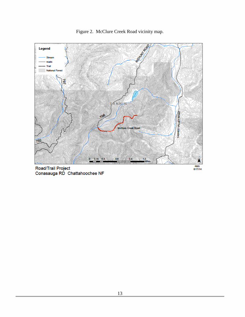
McClure Creek Road (FSR 796) is located at the end of Wehunt Road, south of Georgia Highway
2 in Fannin County (Appendix A, Figure 2). It is a dead-end road with a total length is 3.5 miles.
The segment of the road past the McClure Creek crossing is proposed for decommissioning. This
1.6 mile segment is in poor condition and contributes sediment to McClure Creek. Actions
proposed in this area would be similar to those on the Patterson Creek Road.
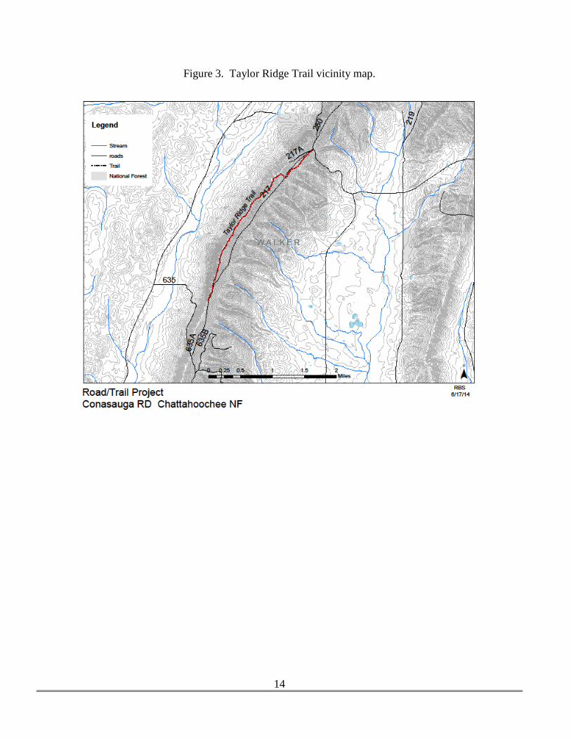
Taylor Ridge Trail is a hiker-only trail 2.7 miles in length along Taylor Ridge in Walker County,
Georgia (Appendix A, Figure 3). It does not provide a connection to other trails or facilities and
parallels South Maddox Gap Road (FSR 217), a gated system road. Usage of the trail is very low,
and primary use is hunting. Hunters can access the same area on foot via FSR 217, which is closed
to the public year-round. Decommissioning of this trail would involve removal of signs and repair
of three drain dips, because vegetation is already beginning to obliterate the trail.
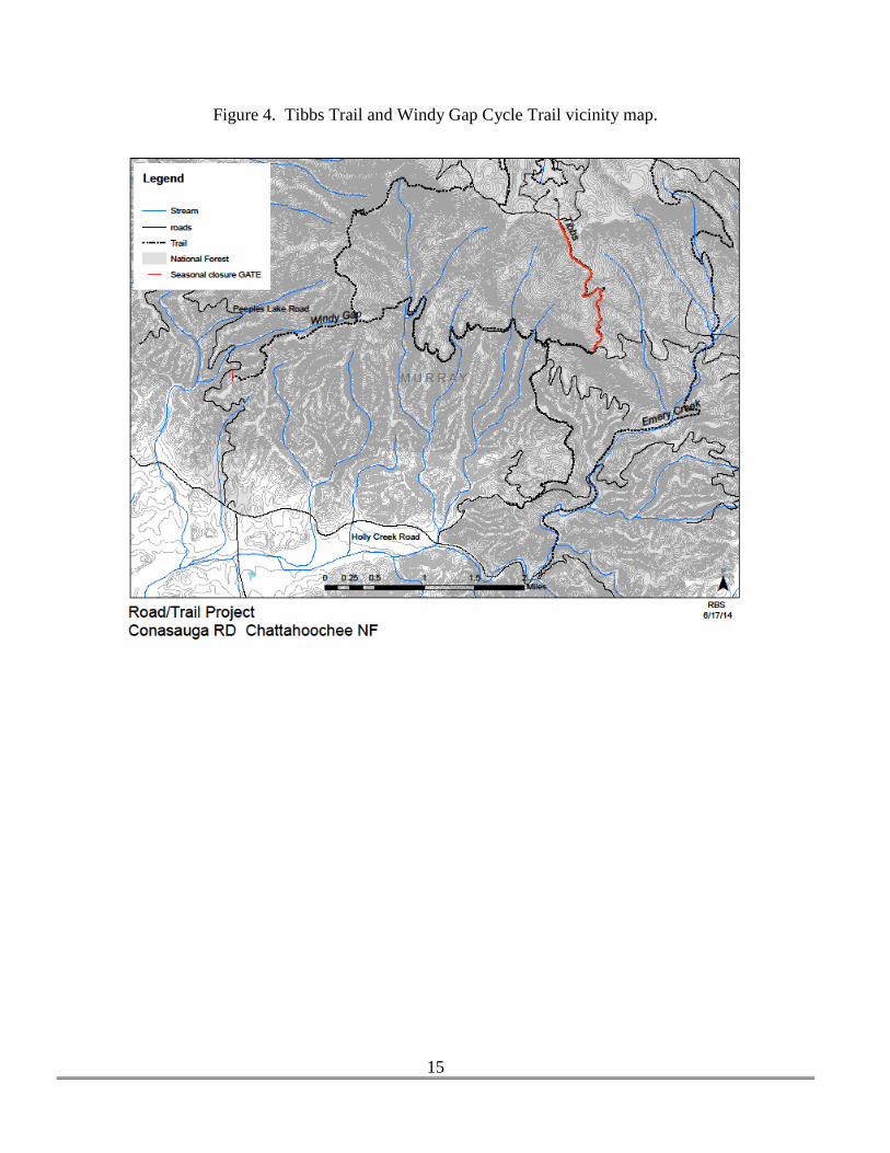
Tibbs Trail is an OHV trail located in the Holly Creek watershed (Appendix A, Figure 4). It was
formerly a road requiring frequent heavy maintenance due to its steep grade and highly erodible
soils. It was designated an OHV trail approximately 20 years ago, and OHVs have damaged the
roadbed. Deep gullies and obstacles such as exposed rock ledges and boulders have resulted, and
the upper 1.5 mile segment of this trail is now nearly impassable, with more recent user-created
trails bypassing this area. This segment is proposed for decommissioning. This would require
heavy equipment to block access to the roadbed, remove culverts, and reshape the former roadbed
Page 8
4
to restore proper contours for drainage. Several user-made side trails would be blocked with similar
methods. The upper trailhead on FSR 68 (Potato Patch Road) would be eliminated as well.
Rock Creek OHV trail and the Windy Gap/Milma Creek/Tibbs OHV trail networks are
proposed for seasonal closure (approximately January 1 – March 31) in order to decrease resource
damage (Appendix A, Figures 4 and 5). Gates would be placed at trail entrances, and other access
control methods (barriers such as boulders, posts, fencing, or berm construction) could be used in
conjunction with gate closures if necessary.
CHAPTER 3 –ENVIRONMENTAL CONSEQUENCES
SOIL AND WATER RESOURCES/AQUATIC HABITATS
CURRENT CONDITION – Areas naturally most susceptible to water quality problems are those where
soil compaction is severe, slopes are steep, soil types are loamy versus sandy or clayey, and where rainfall
events are typically prolonged and intense (Ouren et al. 2007). The sites proposed for decommissioning
are good examples of this characterization. Forest soils in the vicinity of the roads and trails proposed for
closure (as well as much of the forest in general) have severe erosion hazard ratings due to their steep
slopes and soil parent material and structure (various loam complexes) (USDA, NRCS 2014). OHVs and
four-wheel-drive vehicles in areas with these characteristics can severely damage vegetation, soils, water
quality, and aquatic habitat in a very short amount of time.
Weather in the mountains of north Georgia is an important factor influencing soil and water quality condi-
tions on unpaved roads and trails. A measurable amount of rain falls on about 120 days each year totaling
about 60 inches per year, and freezing temperatures are expected on 50 to 70 days per year (National
Weather Service 2014). Motorized use of unpaved roads and trails following heavy rains and when soils
are frequently freezing and thawing can affect soils and vegetation very quickly. Each of the roads and
trails proposed for decommissioning or seasonal closure are currently open year-round, in all weather con-
ditions.
The roads proposed for decommissioning (Patterson Creek Road and a portion of McClure Creek Road) are
dirt-surfaced, with little or no gravel surfacing. The roadbeds are compacted and eroding, with significant
rutting for long distances. User-made side roads with similar or worse conditions are present as well. Poor
surface drainage and lack of a “crowned” roadbed condition has created a water conduit that channels and di-
rects water flow containing sediments and contaminants. Continuing erosion and a lack of maintenance has
caused berms to form along the road shoulders. These berms create depressions and gullies within the
roadbed because runoff cannot escape from the road surface. Collected runoff from the roads washes into
the stream crossings, carrying sediment and fine materials into streams.
Sediment has a detrimental effect on fish and other aquatic life by embedding or smothering habitat and
interfering with feeding and reproduction due to high turbidity. Fish diversity in Tumbling Creek is lower
than predicted, most likely due to the effect of sediments from unpaved roads in the watershed (Georgia
Department of Natural Resources data and Georgia 303(d) list – streams not supporting designated uses).
Improving water quality in this stream is vital to the continued existence of a population of the rare eastern
hellbender salamander (Cryptobranchus allegheniensis), in addition to all the other native fish and inverte-
Page 9
5
brates and a population of rainbow trout (Salmo gairdneri). Patterson Creek and McClure Creek’s aquatic
species health is also at risk due to similar road conditions.
A similar situation exists on Tibbs Trail (a former system road converted into an OHV trail). Erosional
forces have continuously been exerted until significant amounts of bare rock are exposed. Sedimentation
to streams is less severe because the trail is located high in the Holly Creek drainage and crosses only
ephemeral drainages.
Vegetation and soils in the trail tread on the Rock Creek and Windy Gap OHV trail networks are damaged
by OHVs during the winter and early spring months when conditions are freezing and thawing. This has
made trail maintenance more difficult and costly, and is a source of sedimentation to streams.
Soil conditions on Taylor Ridge Trail are stable due to its ridge-top position, vegetated tread, and non-
motorized designation.
EFFECTS OF THE PROPOSED ACTION
The actions required to decommission FSR 124, a portion of FSR 796, and the upper segment of Tibbs
Trail could have localized, short-term direct effects to soils and water quality as heavy equipment reshapes
the roadbed for proper drainage and removes culverts. These actions would be performed in accordance to
Forest Plan standards and current Georgia Rules and Regulations for Water Quality Control for all projects
as a minimum to meet water quality objectives (Georgia Soil and Water Commission 2000). This includes
direction for stabilizing all disturbed soils with straw mulch, the placement of erosion control devices such
as silt fence or hay bales, the requirement for temporary or permanent vegetation within 14 days, and the
recommended spacing for water diversion structures depending on grade. After completion of the closure
actions, the project would have an overall positive effect on soil and water resources and associated aquatic
habitat.
The actions required to seasonally close the ORV trails would have no direct effect on soil and water re-
sources because actions would be extremely limited: gates would be installed, and possibly boulders, posts,
or fencing installed or berms constructed. The indirect effects of the seasonal closure would be positive
due to the removal of motorized traffic on the trails during the season of freeze/thaw conditions and early
spring rains.
The decommissioning of Taylor Ridge Trail and the upper Tibbs Trailhead would have little or no direct or
indirect effect on soils, water quality, or aquatic habitat.
There are no other past, present, or reasonably foreseeable future actions planned in these areas which
could combine with the proposed action and create detrimental cumulative effects.
PUBLIC ACCESS
CURRENT CONDITION - Some individuals and user groups which use the roads and trails proposed for
decommissioning and/or seasonal closure for recreational purposes or access to certain areas of the Nation-
al Forest expressed opinions about the limitation of that access. Both positive and negative opinions were
expressed. Each of the areas proposed for a change in access is currently open year-round.
FSR 124 – Several respondents felt strongly that the closure of FSR 124 would negatively affect their
ability to use the area. Although a significant percentage of this road is located on private property, the
road has been open to public use for over 80 years, possibly much longer. Fannin County does not
Page 10
6
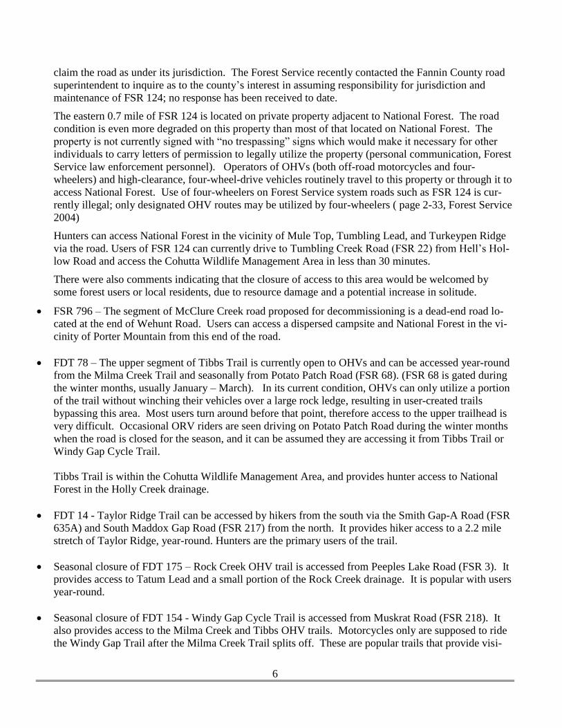
claim the road as under its jurisdiction. The Forest Service recently contacted the Fannin County road
superintendent to inquire as to the county’s interest in assuming responsibility for jurisdiction and
maintenance of FSR 124; no response has been received to date.
The eastern 0.7 mile of FSR 124 is located on private property adjacent to National Forest. The road
condition is even more degraded on this property than most of that located on National Forest. The
property is not currently signed with “no trespassing” signs which would make it necessary for other
individuals to carry letters of permission to legally utilize the property (personal communication, Forest
Service law enforcement personnel). Operators of OHVs (both off-road motorcycles and four-
wheelers) and high-clearance, four-wheel-drive vehicles routinely travel to this property or through it to
access National Forest. Use of four-wheelers on Forest Service system roads such as FSR 124 is cur-
rently illegal; only designated OHV routes may be utilized by four-wheelers ( page 2-33, Forest Service
2004)
Hunters can access National Forest in the vicinity of Mule Top, Tumbling Lead, and Turkeypen Ridge
via the road. Users of FSR 124 can currently drive to Tumbling Creek Road (FSR 22) from Hell’s Hol-
low Road and access the Cohutta Wildlife Management Area in less than 30 minutes.
There were also comments indicating that the closure of access to this area would be welcomed by
some forest users or local residents, due to resource damage and a potential increase in solitude.
FSR 796 – The segment of McClure Creek road proposed for decommissioning is a dead-end road lo-
cated at the end of Wehunt Road. Users can access a dispersed campsite and National Forest in the vi-
cinity of Porter Mountain from this end of the road.
FDT 78 – The upper segment of Tibbs Trail is currently open to OHVs and can be accessed year-round
from the Milma Creek Trail and seasonally from Potato Patch Road (FSR 68). (FSR 68 is gated during
the winter months, usually January – March). In its current condition, OHVs can only utilize a portion
of the trail without winching their vehicles over a large rock ledge, resulting in user-created trails
bypassing this area. Most users turn around before that point, therefore access to the upper trailhead is
very difficult. Occasional ORV riders are seen driving on Potato Patch Road during the winter months
when the road is closed for the season, and it can be assumed they are accessing it from Tibbs Trail or
Windy Gap Cycle Trail.
Tibbs Trail is within the Cohutta Wildlife Management Area, and provides hunter access to National
Forest in the Holly Creek drainage.
FDT 14 - Taylor Ridge Trail can be accessed by hikers from the south via the Smith Gap-A Road (FSR
635A) and South Maddox Gap Road (FSR 217) from the north. It provides hiker access to a 2.2 mile
stretch of Taylor Ridge, year-round. Hunters are the primary users of the trail.
Seasonal closure of FDT 175 – Rock Creek OHV trail is accessed from Peeples Lake Road (FSR 3). It
provides access to Tatum Lead and a small portion of the Rock Creek drainage. It is popular with users
year-round.
Seasonal closure of FDT 154 - Windy Gap Cycle Trail is accessed from Muskrat Road (FSR 218). It
also provides access to the Milma Creek and Tibbs OHV trails. Motorcycles only are supposed to ride
the Windy Gap Trail after the Milma Creek Trail splits off. These are popular trails that provide visi-
Page 11
7
tors (including hunters and anglers) access to a fairly large area in the Holly Creek drainage (within the
Cohutta Wildlife Management Area).
EFFECTS OF THE PROPOSED ACTION
There are approximately 1350 miles of Forest Service Roads on the Chattahoochee National Forest, half of
which is maintained for passenger car use. The remaining half is maintained for high-clearance vehicles or
is closed to vehicle traffic (USDA Forest Service 2004a). Road maintenance budgets have steadily fallen
in the past 10 years, while recreational traffic has risen. This traffic increases the maintenance work neces-
sary to keep the roads in a safe and sustainable condition. The Forest is to the point where, as stated above
in the Purpose and Need section of this document, “roads become candidates for decommissioning when
maintenance needs and resource impacts outweigh access needs.”
The direct effect of decommissioning FSR 124 and a portion of FSR 796 on the quality of the human envi-
ronment would be a reduction in motorized access to some small sections of National Forest. Hunters re-
trieving big game may be affected. Areas such as Mule Top, Tumbling Lead, Turkeypen Ridge, and Por-
ter Mountain would be further from roads; however, there is alternative access from other roads. Porter
Mountain is accessible from Hickory Nut Road (FSR 797) and Cashes Valley Road (county road). Mule
Top, Turkeypen Ridge, and Tumbling Lead are accessible on foot from Tumbling Creek Road and Sholey
Creek-A (FSR 22A).
Forest users that live in the Hell’s Hollow vicinity would experience additional travel time to get to Tum-
bling Creek Road (approximately 14 additional miles).
Closure of the roads would increase the satisfaction of visitors that prefer solitude and fewer disturbances,
as well as those that consider the protection of natural ecosystems paramount to other concerns. The area
would still be accessible on foot (if private property can be traversed).
The closure of FDT 14 would have little effect on the human environment or limitations on recreational
non-motorized access. Forest visitors could still access the area on Taylor Ridge on foot or on FSR 217.
The closure and decommissioning of the upper portion of FDT 78 and its upper trailhead on FSR 68 would
have a minor direct effect on recreational users. Most users are unable to travel the trail in its current con-
dition, but for those that have chosen to do so in the past, this area would be inaccessible to them by motor-
ized vehicle. As with the roads discussed above, hunters retrieving big game may be affected for a few
days each year.
The seasonal closure of FDT 154 and 175 would directly affect users that would normally utilize those trail
systems during the winter and early spring months. They would experience a reduction in motorized ac-
cess to those areas of National Forest for a portion of each year.
OTHER CONSIDERATIONS NOT RELATED TO ISSUES
THREATENED, ENDANGERED, SENSITIVE, AND LOCALLY RARE SPECIES (TES/LR)
The project areas have been analyzed regarding potential effects to rare terrestrial or aquatic species, in-
cluding plants. The effect of the proposed action on the following species was assessed in a Biological
Evaluation:
Page 12
8
Eastern hellbenders (Cryptobranchus alleganiensis alleganiensis) are large salamanders that live in streams
within the Tennessee River drainage in Georgia (as well as other eastern states, mostly in the Appalachian
Mountains). They are fully aquatic salamanders that live in medium- to large-sized streams with cold,
clear water and a rocky bottom, usually in water about 11-23 inches deep (Humphries 2008). Hellbender
populations have drastically declined or disappeared in many areas. The species is listed as Threatened in
Georgia, and a petition for federal listing as Endangered or Threatened has been made to the US Fish and
Wildlife Service (Center for Biological Diversity 2010). The Chattahoochee-Oconee National Forests have
listed the eastern hellbender as Locally Rare. A population of eastern hellbenders is known to exist in both
Tumbling Creek and Fightingtown Creek (Humphries 2005), but not in Patterson Creek or McClure Creek
(headwater tributaries to Fightingtown Creek). The presence of hellbenders is most positively correlated
with the presence of boulders, and is most negatively correlated with the amount of sand/silt (sediment) in
a stream. Sediment embeds the spaces beneath boulders and eliminates space for reproducing hellbenders
(as well as trout and other aquatic species).
The actions associated with decommissioning of the portion of FSR 124 as it crosses Tumbling Creek were
assessed for effects to hellbenders. That portion of the stream is too shallow and lacks the large boulders
essential to hellbenders. It is several miles upstream of the portion occupied by hellbenders. The decom-
missioning actions would have little or no impacts to the species due to the stream protective measures re-
quired by the Forest Plan as well as the Georgia Rules and Regulations for Water Quality. Any minor in-
puts of sediment to Tumbling Creek would be short-term, and after completion of the closure actions, the
project would have an overall positive effect on water quality and associated aquatic habitat.
Several rare species of tree-roosting bats could potentially utilize loose bark or crevices in trees which
might be removed during the implementation of the decommissioning actions. The endangered Indiana
bat (Myotis sodalis), the northern long-eared bat (Myotis septentionalis) which is proposed for federal list-
ing as endangered, and/or the Rafinesque’s big-eared bat (Corynorhinus rafinesquii) could potentially uti-
lize trees in the project areas as summer roost or maternity roost trees. There are no known occurrences of
any of these species in the project areas and the potential for this use is almost discountable. Few trees
(probably less than 10) would be affected, and these would be assessed by a wildlife biologist for potential
use as summer roosts prior to cutting, if the actions occur during the months when bats may be present.
The Biological Evaluation completed for this project includes a determination of ‘not likely to adversely
affect’ the endangered Indiana bat; ‘not likely to jeopardize the existence of the northern long-eared bat;
and a determination that the project is not likely to impact Rafinesque’s big-eared bat.
CULTURAL RESOURCES
The effect of the project on cultural resources was assessed, and because the proposed action is limited to
roads and trails, there is no anticipated effect to archeological resources or Native American resources.
IRREVERSIBLE OR IRRETRIEVABLE COMMITMENT OF RESOURCES
There would be no irretrievable commitment of resources as a result of this proposed action, as there are no
areas proposed for construction of new roads.
CONSISTENCY WITH LAWS
Page 13
9
None of the alternatives threatens a violation of Federal, State, or local law or requirements imposed for the
protection of the environment. Alternatives would be consistent with the following applicable laws and
Executive Orders:
American Indian Religious Freedom Act of 1978
Antiquities Act of 1906 (16 USC 431433)
Archaeological and Historical Conservation Act of 1974 (16 USC 469)
Archaeological Resources Protection Act of 1979 (16 USC 470)
Cave Resource Protection Act of 1988
Clean Air Act of 1977 (as amended)
Clean Water Act of 1977 (as amended)
Endangered Species Act (ESA) of 1973 (as amended)
Forest and Rangeland Renewable Resources Planning Act (RPA) of 1974 (as amended)
Historic Sites Act of 1935 (16 USC 461467)
Multiple Use Sustained Yield Act of 1960
National Environmental Policy Act of 1969, (as amended) (42 USC 43214347)
National Forest Management Act (NFMA) of 1976 (as amended)
National Historic Preservation Act of 1966 (16 USC 470)
Organic Act 1897
Prime Farmland Protection Act
Wild and Scenic Rivers Act of 1968, amended 1986
Forest Service Manuals such as 2361, 2520, 2670, 2620, 2760
Executive Order 11593 (cultural resources)
Executive Order 11988 (floodplains)
Executive Order 11990 (wetlands)
Executive Order 12898 (environmental justice)
Executive Order 12962 (aquatic systems and recreational fisheries)
Executive Order 13112 (NNIS)
CHAPTER 4 –CONSULTATION AND COORDINATION
PREPARERS – FOREST INTERDISCIPLINARY TEAM and CONSULTANTS
Ruth Stokes, District Wildlife Biologist, Conasauga Ranger District
Larry Holsomback, District Civil Engineering Technician, Conasauga Ranger District
Becky Bruce-Vaughters, Archaeologist, Chattahoochee-Oconee National Forests
Jeff Gardner, District Ranger, Conasauga Ranger District
Dick Rightmyer, Forest Soil Scientist, Chattahoochee-Oconee National Forests
Daris Matos, Civil Engineer, Chattahoochee-Oconee National Forests
Page 14
10
AGENCIES AND INDIVIDUALS PROVIDING CONSULTATION AND/OR INPUT
John Damer, Georgia DNR Fisheries Biologist
Dan Forster, Georgia DNR Wildlife Resources
Marty Topa, Georgia Forest Watch
Barnett Chitwood, Northwest Georgia Regional Commission
Charles Collins, Fannin County Roads Department
Steve O’Neal
Shepherd Howell
Vickie Pulliam
Dan and Terri Charron
Cody Graham
Phillip B. Croy
Teresa Pulliam Locke
Douglas Pulliam
Michelle Pulliam
Scott Pulliam
Nicole Pulliam
Diane Bond
Rick Holsomback
Roger Tippens
Roger Shuler
Brenda Barnes
Roger and Linda Pulliam
Page 15
11
LITERATURE CITED
Center for Biological Diversity. 2010. Petition to list 404 aquatic, riparian, and wetland species from the
southeastern United States as Threatened or Endangered under the Endangered Species Act.
Humphries, J. W. 2005. Georgia hellbender status assessment: historic and current distribution,
habitat associations, and the influence of land use on abundance. Unpublished report to Georgia Department of
Natural Resources. 77 pp.
Georgia Department of Natural Resources, Environmental Protection Division. 2014. Georgia’s 2012 In-
tegrated 305(b)/303(d) Report (also referred to as Water Quality in Georgia 2010-2011) GIS Data Sets -
State-Wide Version. Accessed April 17, 2014. http://epd.georgia.gov/geographic-information-systems-gis-
databases-and-documentation
Georgia Soil and Water Commission. 2000. Manual for erosion and sediment control, 5th
edition. Athens,
Georgia.
Humphries, W. J. 2005. Final Report. Georgia Hellbender Status Assessment: Historic and Current Distri-
bution, Habitat Assocations, and the influence of land use on abundance. Prepared for Georgia Department
of Natural Resources Division. 77 pp.
Humphries, W.J. 2008. Hellbender Cryptobranchus alleganiensis. Pp. 154-156 in Jensen, J. B., C.
D. Camp, J. W. Gibbons, and M. J. Elliott (eds.). Amphibians and Reptiles of Georgia.
University of Georgia Press, Athens. 575 pp.
NOAA, National Weather Service. State weather data for Georgia. Accessed April 22, 2014.
http://www.nws.noaa.gov/view/states.php?state=GA&map=on
Ouren, D. S., C. H. Haas, C. P. Melcher, S. C. Stewart, P. D. Ponds, N. R. Sexton, L. Burris, T. Fancher, Z.
H. Bowen. 2007. Environmental effects of off-highway vehicles on Bureau of Land Management lands: a
literature synthesis, annotated bibliographies, extensive bibliographies, and internet resources. U. S. Geo-
logical Survey, Reston, Virginia. 225 pp.
USDA Forest Service. 2004. Land and Resource Management Plan, Chattahoochee-Oconee National For-
ests.
Page 16
12
USDA Forest Service. 2004a. Final Environmental Impact Statement for the Land and Resource Manage-
ment Plan, Chattahoochee-Oconee National Forests.
USDA Natural Resource Conservation Service. 2014. Web soil survey, National Cooperative Soil Survey.
Accessed 4/2/14. http://websoilsurvey.sc.egov.usda.gov/App/HomePage.htm.
APPENDIX A – MAPS
Figure 1. Patterson Creek Road vicinity map.
Page 17
13
Figure 2. McClure Creek Road vicinity map.
Page 18
14
Figure 3. Taylor Ridge Trail vicinity map.
Page 19
15
Figure 4. Tibbs Trail and Windy Gap Cycle Trail vicinity map.
Page 20
16
Figure 5. Rock Creek OHV Trail vicinity map.