UNIVERSITY OF CALIFORNIA, BERKELEY PHYSICAL & ENVIRONMENTAL PLANNING BERKELEY, CALIFORNIA 94720-1382 A & E BUILDING, # 1382 NOTICE OF PREPARATION HILL CAMPUS WILDLAND VEGETATIVE FUEL MANAGEMENT PLAN 1 BERKELEY • DAVIS • IRVINE • LOS ANGELES • MERCED • RIVERSIDE • SAN DIEGO • SAN FRANCISCO SANTA BARBARA • SANTA CRUZ November 20, 2019 State of California Office of Planning and Research 1400 Tenth Street Sacramento, CA 95814 NOTICE OF PREPARATION OF A ENVIRONMENTAL IMPACT REPORT Project Title: Hill Campus Wildland Vegetative Fuel Management Plan Lead Agency: The Regents of the University of California Project Location: University of California, Berkeley Hill Campus, all or portions of the following Assessor’s Parcel Numbers: Alameda County: 048H-7750-001-03, 048H-7753-039-01, 048H-7755-029-01, 048H-7800-002-01, 048H-7900-002-04, 048H-7900-002-06, 048H- 7900-004-01 and 057 -2042-004-10; Contra Costa County: 265-160-005-4 and 265-160- 006-2 Counties: Alameda and Contra Costa Counties Description of the Project The University of California, Berkeley (UC Berkeley) proposes to implement its Wildland Vegetative Fuel Management Plan (Plan) for the UC Berkeley Hill Campus to treat vegetation that could become fire fuel within the 800-acre Plan Area (see Attachment A for location map). The proposed Plan includes implementation of three vegetation treatment types within the Plan Area, including evacuation support treatments, fuel break treatments, and fire hazard reduction treatments. Five types of vegetation treatment activities are proposed to implement the three vegetation treatment types: manual treatment, mechanical treatment, prescribed burning, managed herbivory (livestock grazing), and targeted ground application of herbicides. Additionally, UC Berkeley proposes specific fuel break and fire hazard reduction treatment projects. The Plan includes two specific fuel break projects and three fire hazard reduction projects in designated locations within the Plan Area. Fuel break (FB) projects are proposed on Claremont Ridge (East-West FB) and between the Hill Campus and the Hearst Gate to the Lawrence Berkeley National Laboratory (Hearst Gate FB). The fire hazard reduction (FHR) projects include vegetation treatments in Strawberry Canyon (Strawberry FHR Project), Claremont Canyon (Claremont FHR Project), and on areas along Frowning Ridge (Frowning FHR Project). Implementation of the various treatment types and activities will be reviewed for use throughout the Plan Area at a programmatic level in the Environmental Impact Report (EIR). The identified fuel break and fire hazard reduction treatment projects will be studied at a project level of detail in the EIR. The near-term implementation of the identified treatment projects along with the longer-term implementation of treatment types together comprise the proposed “project” as defined in State CEQA Guidelines Section 15378. The Plan includes the project as defined by CEQA for the purposes of review in this EIR as well as ongoing vegetation treatment maintenance actions described in the 2020 Hill Area Fire Fuel Management Program that have been
Transcript
UNIVERSITY OF CALIFORNIA, BERKELEY
PHYSICAL & ENVIRONMENTAL PLANNING BERKELEY, CALIFORNIA 94720-1382 A & E BUILDING, # 1382
NOTICE OF PREPARATION HILL CAMPUS WILDLAND VEGETATIVE FUEL MANAGEMENT PLAN 1
BERKELEY • DAVIS • IRVINE • LOS ANGELES • MERCED • RIVERSIDE • SAN DIEGO • SAN FRANCISCO SANTA BARBARA • SANTA CRUZ
November 20, 2019
State of California Office of Planning and Research 1400 Tenth Street Sacramento, CA 95814
NOTICE OF PREPARATION OF A ENVIRONMENTAL IMPACT REPORT
Project Title: Hill Campus Wildland Vegetative Fuel Management Plan
Lead Agency: The Regents of the University of California
Project Location: University of California, Berkeley Hill Campus, all or portions of the following Assessor’s Parcel Numbers: Alameda County: 048H-7750-001-03, 048H-7753-039-01, 048H-7755-029-01, 048H-7800-002-01, 048H-7900-002-04, 048H-7900-002-06, 048H-7900-004-01 and 057 -2042-004-10; Contra Costa County: 265-160-005-4 and 265-160-006-2
Counties: Alameda and Contra Costa Counties
Description of the Project
The University of California, Berkeley (UC Berkeley) proposes to implement its Wildland Vegetative Fuel Management Plan (Plan) for the UC Berkeley Hill Campus to treat vegetation that could become fire fuel within the 800-acre Plan Area (see Attachment A for location map). The proposed Plan includes implementation of three vegetation treatment types within the Plan Area, including evacuation support treatments, fuel break treatments, and fire hazard reduction treatments. Five types of vegetation treatment activities are proposed to implement the three vegetation treatment types: manual treatment, mechanical treatment, prescribed burning, managed herbivory (livestock grazing), and targeted ground application of herbicides. Additionally, UC Berkeley proposes specific fuel break and fire hazard reduction treatment projects. The Plan includes two specific fuel break projects and three fire hazard reduction projects in designated locations within the Plan Area. Fuel break (FB) projects are proposed on Claremont Ridge (East-West FB) and between the Hill Campus and the Hearst Gate to the Lawrence Berkeley National Laboratory (Hearst Gate FB). The fire hazard reduction (FHR) projects include vegetation treatments in Strawberry Canyon (Strawberry FHR Project), Claremont Canyon (Claremont FHR Project), and on areas along Frowning Ridge (Frowning FHR Project).
Implementation of the various treatment types and activities will be reviewed for use throughout the Plan Area at a programmatic level in the Environmental Impact Report (EIR). The identified fuel break and fire hazard reduction treatment projects will be studied at a project level of detail in the EIR. The near-term implementation of the identified treatment projects along with the longer-term implementation of treatment types together comprise the proposed “project” as defined in State CEQA Guidelines Section 15378. The Plan includes the project as defined by CEQA for the purposes of review in this EIR as well as ongoing vegetation treatment maintenance actions described in the 2020 Hill Area Fire Fuel Management Program that have been
NOTICE OF PREPARATION HILL CAMPUS WILDLAND VEGETATIVE FUEL MANAGEMENT PLAN 2
approved under UC Berkeley’s 2020 Long Range Development Plan EIR (SCH #2003082131). Maintenance activities included in the 2020 Hill Area Fire Fuel Management Program are not part of the proposed action that will be studied in the Draft EIR.
UC Berkeley has prepared an Initial Study to identify the appropriate document under the California Environmental Quality Act (CEQA), which is included as Attachment B, below. The Initial Study contains a full description of the proposed project including location, objectives, and a preliminary identification of potential environmental effects associated with implementation of the Plan. As documented in the Initial Study, UC Berkeley determined that it will prepare an EIR. The Initial Study also serves to focus the EIR on the effects determined to be potentially significant, pursuant to State CEQA Guidelines Section 15063(c)(3).
Purpose of Notice
The Regents of the University of California will serve as the Lead Agency pursuant to CEQA and has prepared this Notice of Preparation (NOP) to provide responsible and trustee agencies, property owners, and other interested parties with a description of the proposed project and information on potential environmental effects of the proposed project, pursuant to State CEQA Guidelines Section 15082(a). The NOP is available for public review on UC Berkeley’s Capital Strategies website: https://capitalstrategies.berkeley.edu/resources-notices/public-notices.
Project Location and Setting
As shown in Attachment A, the Plan Area is the approximately 800-acre UC Berkeley Hill Campus, which is located in the hills adjoining and east of the UC Berkeley Campus Park and California Memorial Stadium, and is primarily in Alameda County with a small area in unincorporated Contra Costa County. The Plan Area is bounded on the east by Grizzly Peak Boulevard; to the west by Stadium Rim Way and private residences; to the south by Grizzly Peak Boulevard and Claremont Canyon Regional Preserve; and to the north by Lawrence Berkeley National Laboratory (LBNL) and private residences. LBNL manages approximately 200 acres adjacent to the Hill Campus, which are not included in the Plan Area.
Probable Environmental Effects
As described in Attachment B, potential environmental effects of the proposed project would occur to the following resource areas:
• Aesthetics • Air Quality • Biological Resources • Cultural Resources • Geology / Soils • Greenhouse Gas Emissions
• Hazards / Hazardous Materials • Hydrology / Water Quality • Noise • Recreation • Tribal Cultural Resources • Wildfire
Public Review and Comment Period
UC Berkeley invites comments on the scope and content of the Draft EIR and appreciates your prompt review of this NOP. Written comments should focus on the scope and content of the environmental information to be included in the Draft EIR for the Hill Campus Wildland Vegetative Fuel Management Plan germane to agencies having statutory responsibilities associated with the proposed project as well as public interest in the proposed project. All comments on environmental issues received during the public comment period will be considered in the Draft EIR.
NOTICE OF PREPARATION HILL CAMPUS WILDLAND VEGETATIVE FUEL MANAGEMENT PLAN 3
Due to the time limits mandated by State law, this NOP will be circulated for a 30-day review period, which will extend from November 20, 2019, to December 20, 2019. Responses to this NOP must be received by 5:00 PM on Friday, December 20, 2019. Please send your written or electronic responses, with appropriate contact information, to the following address:
Raphael Breines, Senior Planner Physical & Environmental Planning University of California, Berkeley 300 A&E Building, Berkeley, CA 94720-1382 Email: [email protected]
Please include a subject line indicating Scoping Comments: Wildland Vegetative Fuel Management Plan.
Public Scoping Meeting
UC Berkeley will hold a public scoping meeting to inform interested parties about the project, and to provide agencies and the public with an opportunity to provide oral and written comments on the scope and content of the EIR. The meeting time and location are as follows:
Monday, December 2, 2019 Time: 6:30 – 8:00 pm Location: Julia Morgan Hall, UC Botanical Garden at Berkeley Address: 200 Centennial Drive, Berkeley, CA 94720.
*Parking is available in a lot located across the street from the Garden entrance; the cost is $1 per hour. **The meeting facility is accessible to persons with disabilities.
If you have questions concerning this NOP, scoping session, or about environmental review in general for the project, please contact Raphael Breines, Senior Planner, Physical & Environmental Planning, at (510) 642-6796 or [email protected].
Sincerely,
Wendy Hillis Campus Architect, Assistant Vice Chancellor University of California, Berkeley
University of California, Berkeley Capital Strategies – Physical & Environmental Planning
300 A&E Building Berkeley, California 94720-1382
510-643-7384
Contact: Raphael Breines, Project Manager
Prepared By:
Ascent Environmental, Inc. 455 Capitol Mall, Suite 300
Sacramento, California 95814 916/444-7301
Contact: Heather Blair, Project Manager
November 2019
University of California, Berkeley Wildland Vegetative Fuel Management Plan Initial Study i
TABLE OF CONTENTS
Section Page
ACRONYMS AND ABBREVIATIONS ....................................................................................................................................................... vi
1 INTRODUCTION ........................................................................................................................................................................ 1-1 1.1 Introduction and Regulatory Guidance ......................................................................................................................1-1 1.2 Purpose of this Document ..............................................................................................................................................1-1 1.3 Document Organization ................................................................................................................................................. 1-2
2 PROJECT DESCRIPTION ...........................................................................................................................................................2-1 2.1 Plan Overview ..................................................................................................................................................................... 2-1 2.2 Plan Location....................................................................................................................................................................... 2-1 2.3 Past and Current Vegetation Treatments ................................................................................................................ 2-4 2.4 Plan Description ................................................................................................................................................................ 2-4 2.5 Environmental Protection Measures ........................................................................................................................ 2-13
3 ENVIRONMENTAL IMPACTS AND MITIGATION MEASURES ........................................................................................3-1 3.1 Aesthetics ............................................................................................................................................................................ 3-5 3.2 Agriculture and Forest Resources ............................................................................................................................... 3-7 3.3 Air Quality ........................................................................................................................................................................... 3-9 3.4 Biological Resources ....................................................................................................................................................... 3-11 3.5 Cultural Resources ......................................................................................................................................................... 3-14 3.6 Energy................................................................................................................................................................................. 3-16 3.7 Geology and Soils .......................................................................................................................................................... 3-18 3.8 Greenhouse Gas Emissions ......................................................................................................................................... 3-21 3.9 Hazards and Hazardous Materials ........................................................................................................................... 3-23 3.10 Hydrology and Water Quality .................................................................................................................................... 3-27 3.11 Land Use and Planning ................................................................................................................................................. 3-30 3.12 Mineral Resources .......................................................................................................................................................... 3-32 3.13 Noise ................................................................................................................................................................................... 3-33 3.14 Population and Housing .............................................................................................................................................. 3-35 3.15 Public Services ................................................................................................................................................................. 3-36 3.16 Recreation ......................................................................................................................................................................... 3-38 3.17 Transportation ................................................................................................................................................................. 3-40 3.18 Tribal Cultural Resources ............................................................................................................................................. 3-42 3.19 Utilities and Service Systems ..................................................................................................................................... 3-44 3.20 Wildfire ............................................................................................................................................................................... 3-46 3.21 Mandatory Findings of Significance ......................................................................................................................... 3-48
University of California, Berkeley ii Wildland Vegetative Fuel Management Plan Initial Study
Figures Figure 2-1 Plan Area ............................................................................................................................................................................. 2-2
Table 2-2 Overview of Identified Treatment Projects ............................................................................................................. 2-11
Ascent Environmental Acronyms and Abbreviations
University of California, Berkeley Wildland Vegetative Fuel Management Plan Initial Study iii
ACRONYMS AND ABBREVIATIONS AB Assembly Bill ACFD Alameda County Fire Department BAAQMD Bay Area Air Quality Management District BFD Berkeley Fire Department BUSD Berkeley Unified School District CAL FIRE California Department of Forestry and Fire Protection Caltrans California Department of Transportation CEC California Energy Commission CEQA California Environmental Quality Act CO carbon monoxide CRHR California Register of Historical Resources dB decibel dBA A-weighted decibel scale DOC California Department of Conservation DPR Department of Pesticide Regulation DPR Department of Pesticide Regulation EBRPD East Bay Regional Park District EIR environmental impact report EPA U.S. Environmental Protection Agency EPM Environmental protection measures FB Fuel break FHR fire hazard reduction FHSZ Fire Hazard Severity Zones FMMP Farmland Mapping and Monitoring Program GHG greenhouse gases HCP Habitat Conservation Plan HSC Health and Safety Code HWHF Hazardous Waste Handling Facility I-80 Interstate 80 IEPR Integrated Energy Policy Report IS Initial Study LBNL Lawrence Berkeley National Laboratory LRDP Long Range Development Plan MRZ Mineral Resources Zones NAAQS National Ambient Air Quality Standards NCCP Natural Community Conservation Plan NO2 nitrogen dioxide NOP notice of preparation NRHP National Register of Historic Places
Acronyms and Abbreviations Ascent Environmental
University of California, Berkeley iv Wildland Vegetative Fuel Management Plan Initial Study
O3 ozone OPR Governor’s Office of Planning and Research OUSD Oakland Unified School District Pb lead PCA Pesticide Control Advisor PG&E Pacific Gas & Electric Plan Area or Hill Campus UC Berkeley Hill Campus PM10 particulate matter less than 10 microns in diameter PM2.5 particulate matter less than 2.5 microns in diameter PRC Public Resources Code SB Senate Bill SFBAAB San Francisco Bay Area Basin SMP smoke management plan SO2 sulfur dioxide SPRP Spill Prevention and Response Plan SR-24 State Route 24 UC Berkeley University of California, Berkeley UCOP University of California, Office of the President UCPD University of California Police Department VdB vibration decibels VMT vehicle miles traveled Williamson Act California Land Conservation Act WVFMP or Plan Wildland Vegetative Fuel Management Plan
University of California, Berkeley Wildland Vegetative Fuel Management Plan Initial Study 1-1
1 INTRODUCTION
1.1 INTRODUCTION AND REGULATORY GUIDANCE This Initial Study (IS) has been prepared by the University of California, Berkeley (UC Berkeley) to evaluate potential environmental effects resulting from implementation of the proposed Wildland Vegetative Fuel Management Plan (WVFMP or Plan) for the UC Berkeley Hill Campus (Plan Area or Hill Campus). The purpose of the Plan is to reduce wildfire risk and diminish or avoid the harmful effects of wildfire on people, property, and natural resources within the Hill Campus. Under the Plan, UC Berkeley proposes to implement three vegetation treatment types within the Hill Campus: 1) evacuation support treatments, 2) fire hazard reduction treatments, and 3) fuel break treatments.
Five types of vegetation treatment activities are proposed to implement the three vegetation treatment types; these include manual treatment, mechanical treatment, prescribed burning, managed herbivory (livestock grazing), and targeted ground application of herbicides. These proposed vegetation treatment types and activities would be reviewed for use throughout the entire 800-acre Plan Area. The specific locations where these vegetation treatments would be implemented would be dictated by the site-specific vegetative conditions and objectives of the treatment, local assets at risk, ecological conditions, and other factors.
UC Berkeley has developed five proposed treatment projects, consistent with the treatment types and activities described above. These are referred to as “Identified Treatment Projects,” and comprise strategically placed fuel breaks and fire hazard reduction treatment types, using manual and mechanical treatment activities as well as targeted application of herbicides.
This document has been prepared in accordance with the California Environmental Quality Act (CEQA) (Public Resources Code Section 21000 et seq.) and the State CEQA Guidelines (California Code of Regulations Section 15000 et seq.). Under CEQA, an IS can be prepared by a lead agency to determine if a project may have a significant effect on the environment (CEQA Guidelines Section 15063[a]), which will determine the appropriate environmental document to prepare. The IS can also be used to focus the analysis of an EIR on only those topics for which there may be a significant environmental impact. In this circumstance, UC Berkeley has determined, based on the IS, that potentially significant physical environmental impacts may occur to some resources, and they require evaluation in and preparation of an environmental impact report (EIR).
Implementation of the various treatment types and activities will be reviewed for use throughout the Plan Area at a programmatic level in the EIR. The five identified treatment projects will be studied at a project level of detail in the EIR. The near-term implementation of the identified treatment projects along with the longer-term implementation of treatment types, together comprise the proposed “project,” as defined in State CEQA Guidelines Section 15378. Under the existing 2020 Hill Area Fire Fuel Management Program (UC Berkeley 2003), UC Berkeley currently undertakes ongoing vegetation treatment maintenance actions that have been approved under the 2020 Long Range Development Plan EIR (UC Berkeley 2004), (refer to Section 2.3 for additional information). The existing 2020 Hill Area Fire Fuel Management Program will be incorporated into the Plan. These activities will be described in the Plan but have already been reviewed under CEQA and are therefore not part of the proposed action that will be studied in the EIR. The Plan will be reviewed by the UC Berkeley Fire Mitigation Committee. The UC Berkeley Chancellor is the decision-making body with discretionary authority to approve the Plan and certify the EIR.
1.2 PURPOSE OF THIS DOCUMENT In accordance with provisions of CEQA, UC Berkeley is distributing a notice of preparation (NOP) of an EIR, along with this IS, to solicit comments on the scope of the EIR for proposed Plan implementation. The EIR will address the potentially significant environmental impacts of the proposed WVFMP, measures to mitigate these impacts, and alternatives that could reduce or avoid environmental impacts while attaining the basic objectives of the Plan. A Draft
Introduction Ascent Environmental
University of California, Berkeley 1-2 Wildland Vegetative Fuel Management Plan Initial Study
EIR will be prepared and circulated for agency and public review, and a Final EIR will be prepared to address public comments on the Draft EIR.
As required by CEQA, this document is being made available for a 30-day public review period to responsible agencies, trustee agencies, interested parties and organizations, and individuals who could have an interest in the Plan. The public review period begins on November 20, 2019, and ends on December 20, 2019. During the 30-day review period, comments from the public, organizations, and agencies on environmental issues and alternatives that should be considered in the EIR may be submitted to UC Berkeley. Written comments may be provided by email or mail carrier and must be received by 5:00 p.m. on December 20, 2019. Comments should be sent to:
Raphael Breines, Senior Planner Physical & Environmental Planning University of California, Berkeley 300 A&E Building, Berkeley, CA 94720-1382
E-mail comments may be addressed to [email protected], please include “Wildland Vegetative Fuel Management Plan” in the subject line.
Digital copies of the NOP and IS are available on the internet at: https://capitalstrategies.berkeley.edu/resources-notices/public-notices. Printed copies of the NOP and IS are available for public review at the following locations:
A&E Building Physical & Environmental Planning Berkeley, CA 94720 Call 510-643-7384 to arrange a visit
1.3 DOCUMENT ORGANIZATION This IS is organized as follows:
Chapter 1: Introduction. This chapter provides an introduction to the environmental review process and the regulatory guidance under which this document has been prepared. It also describes the purpose and organization of this document.
Chapter 2: Project Description. This chapter provides a detailed description of the Plan.
Chapter 3: Environmental Checklist. This chapter presents an analysis of the environmental issues identified in the CEQA Environmental Checklist (Appendix G of the State CEQA Guidelines) and a determination whether implementation of the Plan would result in no impact, a less-than-significant impact, or a potentially significant impact. If any impacts are determined to be potentially significant, further study of the impact will be conducted and disclosed in the EIR.
Chapter 4: References. This chapter lists the references used in preparation of this IS.
Chapter 5: List of Preparers. This chapter identifies report preparers.
University of California, Berkeley Wildland Vegetative Fuel Management Plan Initial Study 2-1
2 PROJECT DESCRIPTION
2.1 PLAN OVERVIEW The Wildland Vegetative Fuel Management Plan (WVFMP or Plan) for the UC Berkeley Hill Campus (Plan Area or Hill Campus) is proposed by the University of California, Berkeley (UC Berkeley) to treat vegetation that could become fire fuel within the Plan Area. The proposed Plan includes implementation of three vegetation treatment types across the Hill Campus, which are referred to as evacuation support treatments, fuel break treatments, and fire hazard reduction treatments. Five types of vegetation treatment activities are proposed to implement the three vegetation treatment types; these include manual treatment, mechanical treatment, prescribed burning, managed herbivory (livestock grazing), and targeted ground application of herbicides. These vegetation treatment types and activities are reviewed for use throughout the entire 800-acre Plan Area.
The Plan also identifies two specific fuel break projects and three specific fire hazard reduction projects in designated locations (project areas) within the Plan Area. Fuel break (FB) projects are proposed on Claremont Ridge (East-West FB) and between the Hill Campus and the Hearst Gate to the Lawrence Berkeley National Laboratory (LBNL) (Hearst Gate FB). The fire hazard reduction (FHR) projects include vegetation treatments in Strawberry Canyon (Strawberry FHR Project), Claremont Canyon (Claremont FHR Project), and on areas along Frowning Ridge (Frowning FHR Project). These specific projects are collectively referred to as the “Identified Treatment Projects.”
As described in Section 1, implementation of the various treatment types and activities will be reviewed for use throughout the Plan Area at a programmatic level in the EIR. The five Identified Treatment Projects will be studied at a project level of detail in the EIR. The near-term implementation of the five Identified Treatment Projects along with the longer-term implementation of treatment activities studied at a program level, together comprise the proposed “project,” as defined in State CEQA Guidelines Section 15378. Under the existing 2020 Hill Area Fire Fuel Management Program, UC Berkeley currently undertakes ongoing vegetation treatment maintenance actions that have been approved under the 2020 Long Range Development Plan EIR (refer to Section 2.3 for additional information). The existing Hill Area Fire Fuel Management Program will be incorporated into the Plan to consolidate all of UC Berkeley’s fuel management activities in one document, but will not be studied in the EIR.
2.2 PLAN LOCATION The Plan Area is the approximately 800-acre UC Berkeley Hill Campus, which is located in the hills adjoining and east of the UC Berkeley Campus Park and California Memorial Stadium, and is primarily in Alameda County with a small area in unincorporated Contra Costa County. Approximately 85 percent of the Plan Area is located within the City of Oakland; the lower or westernmost portion of the Plan Area lies within the City of Berkeley. The Plan Area is bounded on the east by Grizzly Peak Boulevard; to the west by Stadium Rim Way and private residences; to the south by Grizzly Peak Boulevard and the East Bay Regional Park District’s (EBRPD’s) Claremont Canyon Regional Preserve; and to the north by LBNL and private residences. LBNL manages approximately 200 acres adjacent to the Hill Campus, which are not included in the Plan Area. The Identified Treatment Projects are located within the boundary of the 800-acre Plan Area. Refer to Figure 2-1 and Figure 2-2 for a regional map of the Plan Area and a map of the Identified Treatment Projects, respectively.
Project Description Ascent Environmental
University of California, Berkeley 2-2 Wildland Vegetative Fuel Management Plan Initial Study
Source: University of California, Berkeley 2019
Figure 2-1 Plan Area
Ascent Environmental Project Description
University of California, Berkeley Wildland Vegetative Fuel Management Plan Initial Study 2-3
Source: data downloaded from University of California, Berkeley in 2019
Figure 2-2 Identified Treatment Projects
Project Description Ascent Environmental
University of California, Berkeley 2-4 Wildland Vegetative Fuel Management Plan Initial Study
2.3 PAST AND CURRENT VEGETATION TREATMENTS Although not part of the proposed Project, UC Berkeley maintains an approved and ongoing program of vegetation treatment and maintenance activities in the Plan Area to reduce fire risk to the UC Berkeley campus, LBNL, neighboring residents, recreational visitors, and to adjacent park and watershed lands. Past, ongoing, and planned vegetation treatments described in the existing 2020 Hill Area Fire Fuel Management Program include defensible space and roadside treatments; roadside turnout and signpost treatments; exotic plant removal; hazard tree removal; and tree planting (i.e., replacing flammable vegetation with more fire-resistant vegetation). These ongoing activities have been addressed in either the UC Berkeley 2020 Long Range Development Plan EIR (State Clearinghouse No. 2003082131) or are otherwise exempt from CEQA. These activities will be described in the Plan but have already been reviewed under CEQA and are therefore not part of the proposed project that will be studied in the EIR.
Ongoing defensible space treatments involve vegetation removal in areas within 100 feet of any structure, consistent with California State PRC 4291. Roadside treatments are implemented as emergency evacuation support measures along major roads and trails within and bounding the Plan Area. Roadside treatments involve vegetation removal and are conducted along the strip of land up to 100 feet of the edge of pavement from both sides of designated roadways and trails for brush vegetation and tree removal or pruning.
Roadside turnout and signpost treatments involve cutting grass and removing debris within a 50-foot radius of designated turnouts and around selected signposts. For exotic plant removal, UC Berkeley pulls or cuts eucalyptus, Monterey pine, and French broom seedlings, and applies herbicides to the cut exotic plants according to recommendations of a Pesticide Control Advisor (PCA). Hazard tree removal involves removing dead and hazardous trees or limbs that pose a public safety risk. Tree planting is conducted under the supervision of Facilities Services Fire Mitigation Program Manager. Native trees, including oaks, maples, and buckeyes are selected by staff, with volunteer labor planting the trees in the late winter or spring. This activity has occurred on Tightwad Hill, in openings created from the removal of hazard trees.
Typically, these vegetation treatment activities are carried out under contract by Facilities Services using hand crews and hand-held tools, with occasional use of machinery to cut grass and shrubs and to chip woody material. Herbicides are applied to roadside vegetation by hand-held tools; however, herbicide use is currently limited. Additional vegetation treatment activities are conducted by the Claremont Canyon Conservancy, UC Berkeley Forestry Club and a local non-profit, Take to The Hills, to assist in maintaining the Plan Area through removal of flammable exotic invasive species and planting less flammable species. The combined efforts of restoration work typically exceeds 500 volunteer-days annually.
Using a portion of the funding received by CAL FIRE California Climate Investments Fire Prevention Grant Program, Facilities Services anticipates that it will increase its implementation of defensible space and roadside treatments, roadside turnout treatments, exotic plant removal, hazard tree removal, signpost treatments, and selective tree planting throughout the Plan Area; these activities, which are included in the existing 2020 Hill Area Fire Fuel Management Program, are part of the ongoing treatment and maintenance activities approved in either the UC Berkeley 2020 Long Range Development Plan EIR (State Clearinghouse No. 2003082131) or otherwise exempt from CEQA, as described above.
2.4 PLAN DESCRIPTION
2.4.1 Description of Vegetation Treatment Types Three vegetation treatment types are proposed to be implemented within the 800-acre Plan Area to reduce wildfire risk and increase wildfire resiliency. These include evacuation support treatments, fuel breaks, and fire hazard reduction treatments. These treatment types would be implemented at various locations in the Plan Area based on the conditions and objectives of treatment at a given site, local assets at risk, ecological conditions, and other factors.
Ascent Environmental Project Description
University of California, Berkeley Wildland Vegetative Fuel Management Plan Initial Study 2-5
EVACUATION SUPPORT TREATMENTS Evacuation support treatments are roadside treatments that are proposed along emergency evacuation routes throughout the Hill Campus including these major emergency access routes within and bounding the Plan Area: Stadium Rim Way, Centennial Drive, Grizzly Peak Boulevard, Claremont Avenue, and Jordan Trail. Roadside treatments involve vegetation removal, focusing on trees regardless of species, and are conducted along the strip of land up to 100 feet from the edge of pavement on both sides of designated roadways and trails. Vegetation treatment for evacuation support would focus on removing (including pruning) all trees prone to torching up to 100 feet from either side of major evacuation routes that could potentially block access were they to fall. The secondary focus of vegetation treatments would be to remove understory shrubs and small trees that could enable torching, and would also be implemented up to 100 feet on either side of identified emergency evacuation routes. The buffer for evacuation support treatments could increase to 200 feet in some instances (see below). Criteria for retention of trees includes consideration of whether its removal would facilitate the spreading of invasive plant species and surface fuels, improve habitat within the understory, encourage nesting and improve flight patterns of raptors, and prevent erosion. Treatment activities used to implement evacuation support treatments could include any of the proposed treatment activities identified in Table 2-1 below.
During active treatments, temporary closures of portions of roadways may be needed to allow cutting and skidding of trees close to the road. Typically, roads would be open before 9:00 am and after 3:00 pm on weekdays and no work would occur on weekends. In some cases, only one lane would need to be closed for a few hours at a time. Trails receiving treatments would also be closed to the public as necessary during treatments. UC Berkeley would coordinate with adjacent facilities and local fire departments to plan emergency access or alternative access to the areas served by the roads and trails during closures.
In a few selected locations, usually near intersections of roads and fire trails, all trees and shrubs would be removed in a minimum 200-foot diameter from the edge of pavement or fire trail to create a temporary refuge area for firefighters and evacuees. These places of refuge would be sited in collaboration with local wildfire response agencies. Completion of evacuation support treatments would typically take up to 10 weeks at a time (and would be periodically repeated in subsequent years) but could be longer depending on the size of the treatment area. The conditions of remaining trees would be monitored the year after initial treatment.
FUEL BREAK TREATMENTS Fuel breaks are strategically-located linear strips where vegetation has been treated or removed to aid in the containment of a fire and reduce the likelihood of crown fire transition. To implement fuel break treatments under the Plan, UC Berkeley would either remove understory vegetation and select trees (i.e., shaded fuel breaks) or remove all tree and shrub vegetation in the fuel break area, leaving only some herbaceous vegetation (i.e., non-shaded fuel break) to minimize fire intensity if ignited by a wildland fire. Treatment would also alter the structure of the forest to inhibit torching and ember distribution. Fuel breaks serve the dual purpose of creating a non-burnable area to stop the spread of fire and as a defensive position to enable effective firefighting and fire-retardant application. Fuel break treatments in the Plan Area would could be up to 200 feet wide and installed on ridgelines or other areas naturally low in vegetation to limit the spread of fire from trees between canyons. Treatment activities used to implement fuel break treatments could include any of the proposed treatment activities included in Table 2-1 below. Completion of fuel break treatments would typically take up to 10 weeks at a time but could be longer depending on the size of the fuel break.
Fuel break treatments could be implemented in strategic locations throughout the Plan Area. Two specific fuel break treatment projects are proposed and described in more detail in Section 2.4.4, “Identified Treatment Projects.”
Project Description Ascent Environmental
University of California, Berkeley 2-6 Wildland Vegetative Fuel Management Plan Initial Study
FIRE HAZARD REDUCTION TREATMENTS Fire hazard reduction treatments would focus on reducing hazardous fire conditions in the Plan Area to help promote landscape resiliency and improve native habitat. Fire Hazard Reduction Treatments are less refined than the ongoing defensible space treatments (described in Section 2.3) in several ways: grasses are not mowed and there is no requirement to prune trees. Additionally, shrubs are retained in clumps. Treatments could involve a variety of activities, including manually and mechanically removing high fire hazard vegetation and trees, applying herbicides, and replacing fire-prone vegetation with fire-resistant trees and shrubs. In some limited cases, irrigation could be installed to support the new fire-resistant vegetation. UC Berkeley would evaluate trees and shrubs for vertical and horizontal spacing; remove tall, unhealthy, structurally unsound or highly flammable trees that are likely to torch and distribute embers; and remove short understory trees. Criteria for tree removal would include consideration of tree health, structure, height, potential for failure, flammability/fire hazard, high fuel volume production of small diameter fuels, and competition with other trees (including for water, space, and light). Criteria for retention of trees includes consideration of whether its removal would facilitate the spreading of invasive plant species and inhibit growth of surface fuels, improve habitat within the understory, encourage nesting and improve flight patterns of raptors, and prevent erosion.
Trees cut would be chipped and distributed throughout the treatment area, or kept as logs. In unusual circumstances where the added volume of the tree is insignificant (i.e. where trees are sparse and shrub cover is thick), trees would be bucked, (i.e., cutting a felled and delimbed tree into logs) and the tops cut into lengths no longer than 24 inches and placed beneath the shrub canopy to accelerate decomposition. Trees would be typically cut using a mechanized feller-buncher and hand tools.
To prevent resprouting, an herbicide would be applied to eucalyptus and acacia stumps within 3 minutes of cutting by a licensed California Qualified Applicator. Felled trees would be skidded by rubber-tired or tracked vehicles along skid trails to landings. At landings, trees would be stored or chipped using a grapple-fed chipper or a tracked chipper. Chips would be both spread on-site and transported to a gasifier to supply electricity directly to the campus. Refer to Section 2.7, “Biomass Utilization and Disposal,” for more information about the gasifier. Near roads, trails and buildings, lower limbs of trees would be pruned, understory vegetation shortened, and grass mowed. Completion of fire hazard reduction treatments would typically take up to 10 weeks at a time but could take longer depending on the size of a planned fire hazard reduction project.
Fire hazard reduction treatments could be implemented in various locations throughout the Plan Area. Three specific fire hazard reduction projects are proposed and described in more detail in Section 2.4.4, “Identified Treatment Projects.”
2.4.2 Description of Vegetation Treatment Activities The vegetation treatment activities proposed to implement treatments in the Plan Area include manual treatment, mechanical treatment, prescribed burning, managed herbivory (livestock grazing), and targeted ground application of herbicides. Herbicide use involves only ground-level application, and UC Berkeley does not use aerial applications of herbicides.
Each of these vegetation treatment activities could be used to implement treatment types within the 800-acre Plan Area, and are described in more detail below. Several landings and skid roads exist in the Plan Area from previous logging activities, and no new landings or access roads would be created under the Plan. Some minor grading may be required to remove vegetation and reestablish landings for use during treatment activities.
The vegetation treatment types would be implemented using various combinations of the treatment activities. The treatment activity or activities selected would be those that are most likely to achieve the desired treatment objectives for the specific site, protect natural resource values, and meet the overall Plan objectives. During the planning phase for a vegetation treatment, the appropriate treatment activity or activities would be selected that best match the operational needs and treatment constraints on the landscape. Descriptions of the treatment activities proposed as part of the Plan are summarized in Table 2-1.
Ascent Environmental Project Description
University of California, Berkeley Wildland Vegetative Fuel Management Plan Initial Study 2-7
Table 2-1 Proposed Treatment Activities
Treatment Activity Description Equipment Average
Crew Size Method of Application
Manual Treatment
Use of hand tools and hand-operated power tools to cut, clear or prune herbaceous or woody species
Shovels, Pulaski hoes, McLoed fire tools, machetes, pruning shears, weed whips, weed wrenches, hand saws, chainsaws, mechanized brush cutters, loppers
6-15 Hand pull and grub, thin, prune, hand pile, lop and scatter, hand plant; often combined with prescribed burning
Mechanical Treatment
Use of motorized equipment to cut, uproot, crush/compact, or chop existing vegetation
6-15 Mastication, chipping, brush raking, grading, tilling, mowing, roller chopping, skidding and removal, piling; can be combined with pile burning
Prescribed Burning
Pile burning: Prescribed burning of piles of vegetative material to reduce fuel and/or remove biomass following treatment
Broadcast burning: Prescribed burning to reduce fuels over a larger area or restore fire resiliency in target fire-adapted plant communities; would be conducted under specific conditions related to fuels, weather, and other variables
1-2 fire trucks, water tender, drip torches, 1-2 hand crews
6-15 Pile burning: Place removed fuels in piles on-site and burn using fuel
Broadcast burning: Install fire containment lines around the burn area, then ignite vegetation with a specific pattern of ignition with a control line along the perimeter
Managed Herbivory (livestock grazing)
Use of domestic livestock to reduce fire fuels or competition of desired plant species
Temporary or permanent fencing, water trough
1-2 Grazing or browsing by cows, goats, or sheep
Herbicides Chemical application designed to prevent or inhibit growth of target plant species and include triclopyr, imazapyr and glyphosate-based herbicides. Pre-emergent herbicides, which kill germinating seedlings, may include Snapshot 2.5TG or Surflan AS.
Backpack with hand applicator
1-2 Ground-level application only, such as paint-on stems or stumps and hand-spray applicator. No aerial spray is allowed.
MANUAL VEGETATION TREATMENT Manual vegetation treatment involves the use of hand tools and hand-operated power tools to cut, clear, or prune herbaceous and woody species. Activities could include thinning trees and shrubs; cutting undesired competing brush species; manually pulling, grubbing, or digging out root systems of undesired plants to prevent sprouting and regrowth; and placing mulch, such as wood chips from pruning operations, around desired vegetation to limit competitive growth and minimize erosion. This treatment allows for selective removal of targeted species. Historically, UC Berkeley has often used manual treatments to manage vegetation throughout the Plan Area.
Manual treatments are typically used in developed, sensitive or hard to access areas for small-scale projects. Consequently, ground disturbance associated with manual treatments is typically less than mechanical treatment within an equivalent area. Hand tools include, but are not limited to, shovels, Pulaski hoes, McLeod fire tools, weed whips and “weed wrenches” (tools that pull both shrub and root system out), chain saws, hand saws, mechanized brush cutters, machetes, pruning shears, and loppers. Hand cutting can involve workers using chain saws and wedges
Project Description Ascent Environmental
University of California, Berkeley 2-8 Wildland Vegetative Fuel Management Plan Initial Study
to fell a tree in a direction that facilitates processing. Masticators, which is a mechanical treatment method, and chippers are used occasionally to assist with manual treatments and process cut materials into mulch to remain on-site. Vegetation removed during manual treatments (i.e., biomass) is either left on-site or disposed of by skidding to landings to be chipped, placed as log barriers on campus and then spread on-site, placed in an on-site gasifier to generate energy for the campus, or piling on-site to be burned. Refer to Section 2.4.3, “Biomass Disposal and Utilization,” for more information on handling biomass under the Plan.
Manual treatment crews would typically consist of 6-15 personnel working up to 8 hours per day. As conditions allow, manual treatments would be conducted throughout the year.
MECHANICAL VEGETATION TREATMENT Mechanical vegetation treatment involves the use of heavy motorized equipment, such as feller-bunchers and masticators, specially designed to cut, tear uproot, crush/compact, or chop target vegetation. Mechanical treatment methods that may be used include mowing, masticating (mulching), grubbing, and chipping, among others. Mowing using a tractor reduces fuel height of vegetation and performed at the appropriate time can reduce the amount of manual work needed to maintain an area. Mechanical treatment is effective for removing dense stands of vegetation and is typically used in shrub- and tree-dominated vegetation communities. Mechanical treatments are appropriate where a high level of control over vegetation removal is needed, such as near residential areas or in sensitive habitats. Unless followed with targeted application of herbicides, mechanical treatment has limited use for noxious weed control, as the machinery tends to spread seeds and may not kill root systems.
Depending on the intended purpose, two or more pieces of heavy equipment could be used together. For example, a feller-buncher may be used for cutting material, while another piece of equipment moves the cut material to a landing or staging area where it can then be further treated or transported on-site. Feller-bunchers are used to quickly remove trees and may need to be supported by skidders to move trees and materials. Feller-bunchers are tracked vehicles with a self-leveling cab that mechanically grasps the standing tree, cuts it with a hydraulically powered chain saw, and arranges cut trees in bunches to facilitate dragging the tree out of the forest (skidding). Use of feller-bunchers is limited to slopes of less than approximately 45 percent.
Landings are typically needed to sort, store, and chip cut trees into mulch and spread or remove the material. A flat landing area is typically used for yarding operations, temporary stacking, loading, and trucking logs or brush off the treated site. As previously described, several landings and skid roads exist in the Plan Area from previous logging activities, and no new landings or access roads would be created.
Mechanical treatment crews would typically consist of 6-15 personnel working up to 8 hours per day. As conditions allow, mechanical treatments would be conducted throughout the year.
PRESCRIBED BURNING Prescribed burning is the intentional application of fire in a pre-defined, specific location under prescriptive conditions of fuels, weather, and other variables. Prescribed burning produces low-intensity surface fires that are intended to control vegetation by enhancing the growth, reproduction, or vigor of certain species, in addition to reducing fuel loads and/or maintaining a targeted vegetation community. Surface fire burns along the surface without significant movement into overstory vegetation, with short flame lengths. Typically, prescribed burning uses existing roads and trails as fire containment lines, otherwise fire containment lines are constructed using manual or mechanical treatments. In some cases, vegetation may be trimmed, thinned, or removed manually by prescribed herbivory, hand crews or by mechanical equipment in advance of burning, or vegetation may be pretreated with herbicides to kill the aboveground portions and cause them to dry before burning.
Prescribed burning may be used where other activities are not feasible because of rocky soils, steep slopes, or irregular terrain. Factors that are considered when designing and implementing a prescribed burn include risk to structures and property, land use, environmental impacts, weather conditions, soil stability, slope and aspect, soil type, vegetation types and density, fuel moisture content, time of year, fire return interval, and the efficacy of
Ascent Environmental Project Description
University of California, Berkeley Wildland Vegetative Fuel Management Plan Initial Study 2-9
alternative treatment methods. Burning may occur throughout the year, but it is usually conducted during late spring when the ground is still moist before some plants have set seeds, or during the fall or winter when precipitation is imminent, and plants have completed their yearly growth cycle and their moisture content has declined.
In the past, UC Berkeley has implemented prescribed burns in the Plan Area in late winter when leaf litter is dry but annual grasses are moist and green. Prescribed burns would typically last one day. Equipment used for a prescribed burn would include 1-2 fire engines, an on-site water tender for fire suppression, and ignition devices such as drip torches. Crews implementing prescribed burns would typically consist of 6-15 personnel working up to 8 hours per day. Manual and mechanical treatment activities and associated equipment described above could also be used to prepare an area for a prescribed burn.
Prescribed burns in the Plan Area would require the preparation of a burn plan that includes a smoke management plan (SMP) approved by the Bay Area Air Quality Management District (BAAQMD).
MANAGED HERBIVORY (LIVESTOCK GRAZING) Managed herbivory, also known as “livestock grazing,” is the use of domestic livestock (e.g., goats, sheep, cattle) to accomplish specific and measurable vegetation management objectives. Objectives include removing biomass (fine fuel loads), reducing populations of specific plant species, slowing the re-establishment of shrubs on burned or mechanically thinned sites, and improving plant community structure for wildlife habitat values. Grazing/browsing is best used for green herbaceous plants that produce fine fuels and smaller diameter woody species that produce highly flammable fire fuels. Since the 1980’s, UC Berkeley has used goats to manage grasslands and shrublands in the Plan Area including below the Lawrence Hall of Science, Math Science Research Institute, and Field Station for Animal Behavioral Research.
Livestock are selected according to site conditions and the types of vegetation that need to be managed. Goats are typically best suited to woody vegetation and in steep terrain; sheep eat both forbs and grasses and can be used in a variety of environments; and cattle are better suited to herbaceous plants, especially grasses.
Managed herbivory by domestic livestock could occur throughout the year. Livestock would be deployed in consideration of when the target plant species are palatable and when feeding on the plants can damage them or reduce viable seeds. Additionally, managed herbivory would be restricted during critical growth stages of desirable plant species. The frequency of moving livestock is based on numerous site-specific factors, including slope, density and type of vegetation, stocking rate, type of livestock, and precipitation/moisture content of vegetation. Targeted grazing by livestock requires staff and infrastructure, such as a herder, fencing, mineral block, and supplemental food and/or a watering site to keep the animals within the desired area.
HERBICIDE APPLICATION Herbicides are chemicals that damage or kill plants and are categorized as selective or non-selective. Selective herbicides kill only a specific type of plant, such as broad-leaved plants, which allows the herbicide to be used to control weeds while maintaining grass species. Glyphosate-based herbicides are non-selective and kill any type of plant. Herbicides that may be applied under the proposed Plan include: triclopyr, imazapyr and glyphosate-based products.
To prevent resprouting of removed trees, an herbicide solution would be applied by a licensed California Qualified Applicator with the oversight of a Pesticide Control Advisor (PCA). Typically, 1 to 2 ounces of a diluted solution of herbicide would be applied to the cambium ring of eucalyptus and acacia stumps within 3 minutes of felling. The herbicide mixture would likely consist of a combination of triclopyr and imazapyr in a solution of methylated seed oil, water, and marking dye. Herbicides could also be used for invasive plant control (e.g., French broom) by foliar spraying of vegetation. Triclopyr is approved (see discussion below) for use in and around standing water sites; therefore, it is the only herbicide that would be used within 50 feet water.
Project Description Ascent Environmental
University of California, Berkeley 2-10 Wildland Vegetative Fuel Management Plan Initial Study
UC Berkeley would use the following techniques to apply herbicides:
Cut Stump Application: To maximize the efficacy of treatment, the tree must be cut leaving a stump not more than 4 inches in height above soil surface and the cut surface of the stump must be treated with an herbicide within minutes of the cut. The herbicide is applied to the surface of the stump and is translocated to the roots and disrupts the transportation of nutrients and water, causing the tree to die.
Basal Bark Application: This treatment consists of very low pressure spraying of a solution of triclopyr mixed with esterified vegetable oil to the lower 12 to 15 inches of a resprout. This application method permits the operator to selectively treat resprouts without injury to adjacent vegetation, and is particularly effective on resprouts less than six inches in diameter.
Foliar Spray Application: In foliar spraying, the herbicide is diluted with water at a specific rate, and sprayed over foliage until every leaf is wetted, but not dripping. This method is most suited to shrubs, grasses, and dense vines and would be used for invasive plant control. Foliar spray applications would only be conducted from the ground using hand held application devices.
Effective June 1, 2019, UC President Janet Napolitano issued a temporary suspension, with several exceptions, on the use of glyphosate-based herbicides at all UC locations. Exceptions for use of glyphosate-based herbicides include, among others, fuel-load management programs to reduce wildfire risk. Herbicide application would comply with the U.S. Environmental Protection Agency (EPA) label directions, as well as California Environmental Protection Agency and Department of Pesticide Regulation (DPR) label standards. Herbicide applicators would either possess a valid license or certificate from the California Department of Pesticide Regulation or receive appropriate training and/or direct supervision by a person licensed or certified.
Only ground-level herbicide application would occur; UC Berkeley does not use aerial applications. Limitations in the use of herbicides are addressed by requirements for application methodology, regulatory requirements (e.g., requirement to have a licensed PCA involved in the project), label restrictions, and project-specific guidelines. The limitations intended to be addressed by these requirements include the potential to damage or kill non-target plants; development of a resistance to a particular herbicide over time; or toxicity in humans, animals, birds, amphibians, reptiles, insects, and fish.
TREATMENT MAINTENANCE In consideration of the dynamic nature of vegetation communities, treatment activities conducted for maintenance may change over time. The maintenance treatment could be different than the original treatment, such as a manual treatment using chainsaws to create shaded fuel breaks along roads followed by periodic prescribed burning to keep sprouting and fuel loads low. The condition of fuel breaks would be monitored yearly, and would be maintained every 3 to 7 years depending on shrub growth within the area of initial treatment. Areas of evacuation support would be maintained the following year, and then every 5-7 years thereafter. The treatment the following year is needed to evaluate and remove any trees made unstable from increased wind flow through the stand. Other treatment types could be maintained at different intervals depending on the vegetation type and objectives of the treatment. Areas of fire hazard reduction are expected to be maintained every 5-10 years, based on fuel volume and potential ember production and distribution.
2.4.3 Biomass Disposal and Utilization Implementation of the Plan would include the removal of trees and other vegetation. The Plan includes the utilization of a gasifier and a wood-burning hydronic boiler that when used would reduce the generation of greenhouse gases relative to leaving material to decompose, and by replacing a portion of the use of fossil fuels for electricity generation. Accordingly, some of the vegetation removed during treatment activities would be converted to electricity, or hot water, which would substitute for the use of fossil fuels and produce biochar, a charcoal-like
Ascent Environmental Project Description
University of California, Berkeley Wildland Vegetative Fuel Management Plan Initial Study 2-11
substance that can be used to fertilize the soil. The feedstock, or energy, comes from the biomass and the electricity generated would be used directly by the campus.
However, the majority of the biomass created through implementation of the Plan would be chipped and spread directly back onto the treated areas to reduce erosion potential. Chips spread on the hillside within 100 feet of roads and fire trails would have a maximum depth of six inches to prevent erosion and suppress invasive weeds. Some chips would be stockpiled in landings. In unusual circumstances chip depth would be 24 inches in remote locations. Chips are expected to decompose about five inches per year, based on previous treatments in the Hill Campus. A small portion of the biomass would be lopped and scattered. Biomass would also be eaten by livestock. An air curtain incinerator may also be used to dispose of woody biomass, which is similar to a gasifier except no electricity is generated. Whenever possible, biomass material would be fed into the gasifier and a wood-burning hydronic boiler. Some logs would be anchored and utilized on-site for erosion mitigation, wildlife habitat, or as a physical barrier to access by the public. Some minor earthmoving may be required to secure logs in place near slopes. The volume of cut vegetation left on-site would be kept low enough to prevent excessive fuel buildup, interfere with access for monitoring, and encourage establishment of desirable vegetation after treatment. There will be no hauling of cut material from the campus.
2.4.4 Identified Treatment Projects The proposed Identified Treatment Projects comprise strategically placed fuel breaks and fire hazard reduction projects in the Plan Area, totaling approximately 155-acres of treatments (see Figure 2-2) in the 800-acre Hill Campus. Table 2-2 summarizes each of the Identified Treatment Projects, including the specific project names, treatment type, treatment activities, location in the Plan Area, and treatment acreage.
Table 2-2 Overview of Identified Treatment Projects
Project Name Treatment Type Treatment Activities Location Acres
East-West FB Fuel Break Manual, mechanical, herbicide use
Claremont Ridge between UC Berkeley property and Claremont Canyon
Regional Preserve 26
Hearst Gate FB Fuel Break Manual, mechanical, herbicide use
between the Hill Campus and the Hearst Gate to LBNL 5
Strawberry FHR Fire Hazard Reduction Manual, mechanical, herbicide use
Areas in Strawberry Canyon near upper Centennial Drive and upper Jordan Fire
Trail 40
Claremont FHR Fire Hazard Reduction Manual, mechanical, herbicide use
Areas in Claremont Canyon north of Claremont Avenue 30
Frowning FHR Fire Hazard Reduction Manual, mechanical, herbicide use
Areas along Frowning Ridge near the upper Jordan Fire Trail 54
Total 155 Notes: FB = fuel break, FHR = fuel hazard reduction. Numbers are rounded to the nearest whole number.
FIRE HAZARD REDUCTION PROJECTS As shown in Table 2-2, there are three fire hazard reduction projects proposed: the Strawberry FHR Project, the Claremont FHR Project, and the Frowning FHR Project. Together, they would be implemented on approximately 124 acres within the Plan Area. Treatment activities used to implement these projects would include a combination of manual and mechanical treatments to remove vegetation, followed by the use of herbicides to prevent resprouts. Up to 15 personnel would be required to implement each of the fire hazard reduction projects, working up to 8 hours per day, and each project would take up to 6 weeks to complete. These projects are anticipated to be implemented in 2020, 2021 and 2022, as conditions allow. General information regarding fire hazard reduction treatments is provided in Section 2.4.1, “Description of Vegetation Treatment Types,” described above. Biomass created by
Project Description Ascent Environmental
University of California, Berkeley 2-12 Wildland Vegetative Fuel Management Plan Initial Study
vegetation removal would primarily be chipped, and spread directly back onto the treated areas. Some logs would be strategically placed on-site to prevent runoff and erosion near slopes, or to act as physical barriers to access. Near slopes, some minor earth moving may be required to secure logs in place. A small portion of woody biomass would be lopped and scattered in the treatment area, or incinerated in an air curtain or fed in to the gasifier, as described above in Section 2.4.3, “Biomass Disposal.”
Initial work contracts may be issued for several noncontiguous areas, for example, several 5-acre work areas could be treated simultaneously. Subsequent work areas would be contiguous to those already completed, each with a clear path to existing landing areas. Specific elements of each fire hazard reduction project are described below.
Following completion of these projects, UC Berkeley would apply herbicides annually (triclopyr or imazapyr) according to the regulations and label instructions described under “Herbicide Application” in Section 2.4.2, “Description of Vegetation Treatment Activities.” Follow-up treatments annually would include a low-volume herbicide ground spray applied to resprouted foliage and selected seedlings. Follow-up treatments may also include a basal bark application or cutting the sprout and treating the cut surface with herbicide. On some resprouts and seedlings, a glyphosate-based solution may be applied to foliage in combination with imazapyr. Additional maintenance activities would occur every 5-7 years using any of the vegetation treatment activities described in section 2.4.2, “Description of Vegetation Treatment Activities,” above.
Strawberry FHR Project Strawberry FHR Project would be implemented on approximately 40 acres in the northwesternmost part of the Plan Area. Six existing landings are located adjacent to fire trails or paved roads in Strawberry Canyon and project-related equipment would be staged, fueled, and maintained at these landings during project implementation. The Strawberry FHR Project would require the use of three existing unpaved access roads. The roads are approximately 12 feet wide and follow existing logging roads created during work done in 1974 and 1975 and in 1989 and 1990 when trees were last cut in this area. Some minor grading may be required to reestablish existing landings and skid roads for use; however, no import or export of soil would occur.
Claremont FHR Project The Claremont FHR Project would be implemented on approximately 30 acres in the southeastern portion of the Plan Area. Four existing landings that are adjacent to existing fire trails or paved roads in the Claremont Canyon FHR Project would be used for equipment staging, fueling, and maintenance during project implementation. Some minor grading may be required to reestablish existing landings for use; however, no import or export of soil would occur.
Temporary closure of Claremont Avenue may be required for a few hours to allow equipment to move and move off the site. UC Berkeley would coordinate with adjacent facilities and local fire departments to plan emergency access or alternative access to the areas served by the road.
Frowning FHR Project The Frowning FHR Project would be implemented on approximately 54 acres spanning the northern portion of the Plan Area. Eleven landings exist adjacent to fire trails or paved roads in the vicinity of the Frowning FHR Project. Equipment would be staged, fueled, and maintained at these landings. Some minor grading may be required to reestablish existing landings for use; however, no import or export of soil would occur.
Temporary closure of Grizzly Peak Boulevard and the Upper Jordan Fire Trail may be required to allow equipment to move on and off the treatment site. UC Berkeley would coordinate with adjacent facilities and local fire departments to plan emergency access or alternative access to the areas served by the fire trail.
FUEL BREAK TREATMENT PROJECTS As shown in Table 2-2, there are two fuel break treatment projects proposed, the East-West FB Project and the Hearst Gate FB Project; together they would be implemented on approximately 31 acres within the Plan Area. Treatment activities used to establish these fuel breaks would include a combination of manual and mechanical treatments to
Ascent Environmental Project Description
University of California, Berkeley Wildland Vegetative Fuel Management Plan Initial Study 2-13
remove vegetation, followed by the use of herbicides to prevent resprouts. Up to 15 personnel would be required to implement each of the fuel break treatment projects, working up to 8 hours per day, and each would take up to 10 weeks to complete. They would be implemented over 2021 and 2022, as conditions allow. Biomass created by vegetation removal would primarily be chipped and spread directly back onto the treated areas. Some logs would be strategically placed on-site to prevent runoff and erosion near slopes, or to act as physical barriers to access. Near slopes, some minor earth moving may be required to secure logs in place. A small portion of woody biomass would be lopped and scattered in the treatment area or incinerated in an air curtain or fed in to the gasifier, as described above in Section 2.4.3, “Biomass Disposal.”
The fuel break treatment projects would be maintained every 5 to 7 years using any of the vegetation treatment activities described in Section 2.4.2, “Description of Vegetation Treatment Activities,” above.
East-West Fuelbreak Project The East-West FB Project is proposed on Claremont Ridge between UC Berkeley property and Claremont Canyon Regional Preserve. It would be up to approximately 7,390 feet (1.4 miles) in length and 195 feet wide, covering a total of approximately 26 acres of the Plan Area. The East-West FB would be primarily a non-shaded fuel break, although some trees would remain. Therefore, any of the manual and mechanical equipment types could be used (Table 2-1). Cut-stump application of herbicides would occur after manual and mechanical treatments to prevent resprouting. Equipment staging would occur within three existing landings in the vicinity of the East-West FB shown on Figure 2-2. Some minor regrading may be required to clear the landings of vegetation however, no import or export of soil would occur.
Hearst Gate Fuelbreak Project The Hearst Gate FB Project is proposed between the Hill Campus and the Hearst Gate to LBNL. It would be up to approximately 2,260 feet (0.4 miles) in length and 125 feet wide, covering a total of approximately 5 acres of the Plan Area. The Hearst Gate FB would be a shaded fuel break; understory vegetation would be removed, and many trees would remain, as appropriate to achieve the objectives of the treatment. Therefore, any of the manual and mechanical equipment types could be used (Table 2-1). Cut-stump application of herbicides would occur after manual and mechanical treatments to prevent resprouting. Equipment staging would occur within the Foothill Housing parking lot outside of the Plan Area. No grading would be necessary for this project.
2.5 ENVIRONMENTAL PROTECTION MEASURES Environmental protection measures (EPMs) would be incorporated into the design of vegetation treatments in the Plan Area. Specific EPMs will be developed during preparation of the Draft EIR, such as public notifications before implementing certain activities, establishing buffers around sensitive species or habitats, and limiting ground disturbance during or after precipitation events. The EPMs are intended to minimize environmental impacts and comply with applicable laws and regulations and will be evaluated in the Draft EIR.
Project Description Ascent Environmental
University of California, Berkeley 2-14 Wildland Vegetative Fuel Management Plan Initial Study
This page intentionally left bank.
University of California, Berkeley Wildland Vegetative Fuel Management Plan Initial Study 3-1
3 ENVIRONMENTAL CHECKLIST
PROJECT INFORMATION 1. Project Title: Hill Campus Wildland Vegetative Fuel Management Plan
2. Lead Agency Name and Address: The Regents of the University of California University of California, Berkeley 300 A&E Building Berkeley, CA 94720
3. Contact Person and Phone Number: Raphael Breines, (510) 642-6796
4. Project Location: University of California, Berkeley
5. Project Sponsor’s Name and Address: Same as lead agency
6. General Plan Designation: The Plan Area is designated as Open Space by the City of Berkeley General Plan, Resource Conservation Area by the City of Oakland General Plan, and Parks and Recreation by the Contra Costa General Plan; Alameda County has not assigned a land use designation to this area.
7. Zoning: The land within the Plan Area is zoned for high-density (R-5) residential by the City of Berkeley, residential hillside (RH) by the City of Oakland, and Forestry Recreational (F-R) and General Agriculture (A-2) by Contra Costa County; Alameda County has not assigned a zoning district to this area.
8. Description of Project: The Wildland Vegetative Fuel Management Plan for the UC Berkeley Hill Campus is proposed by the University of California, Berkeley to treat vegetation that could become fire fuel within the Plan Area. The proposed Plan includes implementation of three vegetation treatment types across the Hill Campus, which are evacuation support treatments, fuel break treatments, and fire hazard reduction treatments. Five types of vegetation treatment activities are proposed to implement the three vegetation treatment types; these are manual treatment, mechanical treatment, prescribed burning, managed herbivory (livestock grazing), and targeted ground application of herbicides. These vegetation treatment types and activities are reviewed for use throughout the entire 800-acre Plan Area; additionally, there are five specific Identified Treatment Projects proposed. Please refer to Chapter 2, “Project Description” for a detailed description of the project.
9. Surrounding Land Uses and Setting: The Plan Area is bounded on the east by Grizzly Peak Boulevard, to the west by Stadium Rim Way and private residences, to the south by Grizzly Peak Boulevard and the East Bay Regional Park District’s (EBRPD’s) Claremont Canyon Regional Reserve, and to the north by Lawrence Berkeley National Laboratory (LBNL) and private residences.
Environmental Checklist Ascent Environmental
University of California, Berkeley 3-2 Wildland Vegetative Fuel Management Plan Initial Study
10. Other public agencies whose approval is Implementation of the Plan may require approval from the required: following agencies:
Federal U.S Army Corps of Engineers: Compliance with Section 404 of
the Clean Water Act for discharge of fill into Waters of the U.S.
U.S. Fish and Wildlife Service: Compliance with Section 7 or 10 of the federal Endangered Species Act.
State California Department of Fish and Wildlife: Compliance with
the California Endangered Species Act, incidental take authorization permits under Section 2081 of the Fish and Game Code if take of listed species is likely to occur, and Section 1602 streambed alteration notification for activities that occur within the bed or bank of waterways.
San Francisco Regional Water Quality Control Board: National Pollutant Discharge Elimination System construction stormwater permit for disturbance of more than 1 acre, discharge permit for stormwater, and Clean Water Act Section 401 water quality certification or waste discharge requirements.
Local Bay Area Air Quality Management District: Open burn permit
and review of smoke management plans for prescribed burns.
11. Have California Native American tribes traditionally and culturally affiliated with the project area requested consultation pursuant to Public Resources Code section 21080.3.1? If so, is there a plan for consultation that includes, for example, the determination of significance of impacts to tribal cultural resources, procedures regarding confidentiality, etc.?
Three Native American tribes requested to be notified of UC Berkeley CEQA projects. In compliance with Public Resources Code (PRC) section 21080.3.1 consultation, UC Berkeley sent written notification describing the proposed Plan to the three Native American tribes on October 24, 2019. Consultation is ongoing.
Environmental Checklist Ascent Environmental
University of California, Berkeley Wildland Vegetative Fuel Management Plan Initial Study 3-3
ENVIRONMENTAL FACTORS POTENTIALLY AFFECTED: The environmental factors checked below would be potentially affected by this project, involving at least one impact that is a “Potentially Significant Impact” as indicated by the checklist on the following pages. Where checked below, the topic with a potentially significant impact will be addressed in an environmental impact report.
Aesthetics Agriculture and Forest Resources Air Quality Biological Resources Cultural Resources Energy Geology / Soils Greenhouse Gas Emissions Hazards / Hazardous Materials Hydrology / Water Quality Land Use / Planning Mineral Resources Noise Population / Housing Public Services Recreation Transportation Tribal Cultural Resources Utilities / Service Systems Wildfire Mandatory Findings of
Significance None None with Mitigation
Incorporated
Environmental Checklist Ascent Environmental
University of California, Berkeley 3-4 Wildland Vegetative Fuel Management Plan Initial Study
DETERMINATION (To be completed by the Lead Agency) On the basis of this initial evaluation:
I find that the proposed project could not have a significant effect on the environment, and a NEGATIVE DECLARATION will be prepared.
I find that although the proposed project COULD have a significant effect on the environment, there WILL NOT be a significant effect in this case because revisions in the project have been made by or agreed to by the project proponent. A MITIGATED NEGATIVE DECLARATION will be prepared.
I find that the proposed project MAY have a significant effect on the environment, and an ENVIRONMENTAL IMPACT REPORT is required.
I find that the proposed project MAY have a “potentially significant impact” or “potentially significant unless mitigated” impact on the environment, but at least one effect 1) has been adequately analyzed in an earlier document pursuant to applicable legal standards, and 2) has been addressed by mitigation measures based on the earlier analysis as described on attached sheets. An ENVIRONMENTAL IMPACT REPORT is required, but it must analyze only the effects that remain to be addressed.
I find that although the proposed project could have a significant effect on the environment, because all potentially significant effects (a) have been analyzed adequately in an earlier EIR or NEGATIVE
DECLARATION pursuant to applicable standards, and (b) have been avoided or mitigated pursuant to that earlier EIR or NEGATIVE DECLARATION, including revisions or mitigation measures that are imposed upon the proposed project, nothing further is required.
November 20, 2019 Signature Date
Wendy Hillis Campus Architect, Assistant Vice Chancellor Printed Name Title
UC Berkeley Agency
Environmental Checklist Ascent Environmental
University of California, Berkeley Wildland Vegetative Fuel Management Plan Initial Study 3-5
3.1 AESTHETICS
ENVIRONMENTAL ISSUES Potentially Significant
Impact
Less Than Significant with
Mitigation Incorporated
Less Than Significant
Impact
No Impact
I. Aesthetics. Except as provided in Public Resources Code section 21099 (where aesthetic impacts shall not be considered significant for qualifying residential, mixed-use residential, and employment centers), would the project:
a) Have a substantial adverse effect on a scenic vista?
b) Substantially damage scenic resources, including, but not limited to, trees, rock outcroppings, and historic buildings within a state scenic highway?
c) In non-urbanized areas, substantially degrade the existing visual character or quality of public views of the site and its surroundings? (Public views are those that are experienced from publicly accessible vantage points.) If the project is in an urbanized area, would the project conflict with applicable zoning and other regulations governing scenic quality?
d) Create a new source of substantial light or glare which would adversely affect day or nighttime views in the area?
3.1.1 Environmental Setting Aesthetic resources are generally defined as both the natural and built features of the landscape that contribute to the public’s experience and appreciation of the environment. A scenic vista is defined as a viewpoint that provides expansive views of a highly valued landscape for the benefit of the general public.
The 800-acre Plan Area is located within the UC Berkeley Hill Campus in the hills adjoining and east of the UC Berkeley Campus Park and California Memorial Stadium. Existing development within the Plan Area includes several campus public and research facilities such as the Lawrence Hall of Science, Botanical Garden, Space Sciences Laboratory, and the Mathematical Sciences Research Institute.
Areas within the UC Botanical Garden and around the Lawrence Hall of Science support a wide variety of native and non-native trees, shrubs, groundcovers, and turf. Large tracts of eucalyptus and conifer also form a dominant part of the visual landscape within the Plan Area. Stands of blue gum eucalyptus are spread throughout the Strawberry and Claremont Canyon watersheds. The primary use of the Hill Campus is natural open space, including 300-acres, referred to as the Ecological Study Area, preserved by UC Berkeley for education and research. Native vegetation throughout the Plan Area includes areas of oak-bay woodland, north coastal scrub, remnants of oak savanna and native grasslands, and riparian scrub and woodland. The Plan Area also includes the developed Strawberry Canyon Recreation Area, and the adjacent Witter and Levine-Fricke sport fields.
As shown on Figure 2-2, the majority of the Plan Area remains undeveloped with slopes that range from moderate to steep, with rugged terrain. Site topography and vegetation contribute to the visual quality of the Plan Area. Long-range views of scenic features within the Plan Area, including the hillside, undeveloped open space, and a mosaic pattern of vegetation, can be seen from publicly accessibly viewpoints throughout the UC Berkeley campus. Long-
Environmental Checklist Ascent Environmental
University of California, Berkeley 3-6 Wildland Vegetative Fuel Management Plan Initial Study
range views to the west of the San Francisco Bay, San Francisco, Marin County and the Golden Gate Bridge can be seen from the Lawrence Hall of Science, Panoramic Hill and Grizzly Peak Boulevard, within the Plan Area. Viewer groups for the Plan Area include students, residents, motorists, and recreationists.
Regional access to UC Berkeley is provided via Interstates 80 (I-80) and 580 (I-580), and State Routes 24 (SR-24) and 13 (SR-13). None are located within the Plan Area, nor are they designated by the California Department of Transportation (Caltrans) as a state scenic highway (ArcGIS 2019a).
3.1.2 Discussion
a) Have a substantial adverse effect on a scenic vista?
Potentially significant. A scenic vista is defined as a viewpoint that provides expansive views of a highly valued landscape for the benefit of the general public. UC Berkeley proposes to implement vegetation treatments throughout the Plan Area to reduce wildfire risk. The vegetation treatment types, including the fuel break and fire hazard reduction projects, would be implemented using various combinations of the treatment activities as described in Chapter 2, “Project Description.” Implementation of fuel break treatments and prescribed burning under the Plan, would result in removal of vegetation such that a substantial adverse effect on a scenic vista could result; implementation of other treatment types and activities may also result in a substantial adverse effect on a scenic vista, but potentially to a lesser degree. This impact could be potentially significant and will be analyzed further in the EIR.
b) Substantially damage scenic resources, including, but not limited to, trees, rock outcroppings, and historic buildings within a state scenic highway?
Potentially significant. There are no state scenic highways located within the Plan Area; however, portions of the Plan Area may be visible from State Route 24, a state scenic highway. Implementation of proposed treatments would remove vegetation such that varying degrees of damage to scenic resources, including trees, within a state scenic highway could result. This impact could be potentially significant and will be analyzed further in the EIR.
c) In non-urbanized areas, substantially degrade the existing visual character or quality of public views of the site and its surroundings? (Public views are those that are experienced from publicly accessible vantage points.) If the project is in an urbanized area, would the project conflict with applicable zoning and other regulations governing scenic quality?
Potentially significant. As discussed in Criterion (a), implementation of fuel break treatments and prescribed burning would require UC Berkeley to remove vegetation such that varying degrees of degradation to the existing visual character or quality of the Plan Area could result; implementation of other treatment types and activities may also result in degradation of existing visual character or quality, but potentially to a lesser degree. This impact could be potentially significant and will be analyzed further in the EIR.
d) Create a new source of substantial light or glare which would adversely affect day or nighttime views in the area?
No impact. Implementation of the Plan would not result in any new, permanent structures or lighting; therefore, no new sources of light or glare would be created. During treatment activities there would be equipment and vehicles at the designated treatment locations. Light reflected from vehicles and equipment could result in glare to nearby viewers; however, potential glare would be temporary, largely shielded by existing and remaining vegetation, and would be eliminated following conclusion of the treatment activity. Therefore, Plan implementation would have no impact with respect to light or glare and this issue will not be analyzed further in the EIR.
Environmental Checklist Ascent Environmental
University of California, Berkeley Wildland Vegetative Fuel Management Plan Initial Study 3-7
3.2 AGRICULTURE AND FOREST RESOURCES
ENVIRONMENTAL ISSUES Potentially Significant
Impact
Less Than Significant with
Mitigation Incorporated
Less Than Significant
Impact
No Impact
II. Agriculture and Forest Resources. Would the project:
a) Convert Prime Farmland, Unique Farmland, or Farmland of Statewide Importance (Farmland), as shown on the maps prepared pursuant to the Farmland Mapping and Monitoring Program of the California Resources Agency, to non-agricultural use?
b) Conflict with existing zoning for agricultural use or a Williamson Act contract?
c) Conflict with existing zoning for, or cause rezoning of, forest land (as defined in Public Resources Code section 12220(g)), timberland (as defined by Public Resources Code section 4526), or timberland zoned Timberland Production (as defined by Government Code section 51104(g))?
d) Result in the loss of forest land or conversion of forest land to non-forest use?
e) Involve other changes in the existing environment, which, due to their location or nature, could result in conversion of Farmland to non-agricultural use or conversion of forest land to non-forest use?
3.2.1 Environmental Setting The California Department of Conservation (DOC) Farmland Mapping and Monitoring Program (FMMP) prepares maps and statistical data for analyzing land use impacts on California’s agricultural resources. The FMMP categorizes agricultural production potential based on a combination of physical and chemical characteristics of the soil and climate that determine the degree of suitability of the land for crop production. Pursuant to the FMMP, portions of the Plan Area located in Alameda County are designated as Urban and Built-Up Land, and the small area in unincorporated Contra Costa County is designated as Other Land (DOC 2016a; DOC 2016b).
The California Land Conservation Act (Williamson Act) recognizes the importance of agricultural land and includes provisions to protect and ensure the orderly conservation of agricultural land. According to the DOC 2016 Status Report, approximately 138,165 acres of land enrolled under Williamson Act Contract are within Alameda County and 42,944 acres are within Contra Costa County (DOC 2016c:38). However, none are located within the Plan Area.
Pursuant to Forest Inventory and Analysis prepared by United States Department of Agriculture (USDA 2016:6), the land within Alameda County and Contra Costa County is classified as Nonforest. In addition, the Plan Area is zoned for residential use by the City of Berkeley and the City of Oakland. The Plan Area located within Contra Costa County is zoned for Forestry Recreational and General Agriculture (City of Berkeley 2014, City of Oakland 2018, ArcGIS 2019c).
Alameda County has approximately 106.2 acres of forest land, and Contra Costa County has approximately 43.2 acres (DOC 2016c: 82).
Environmental Checklist Ascent Environmental
University of California, Berkeley 3-8 Wildland Vegetative Fuel Management Plan Initial Study
3.2.2 Discussion a) Convert Prime Farmland, Unique Farmland, or Farmland of Statewide Importance
(Farmland), as shown on the maps prepared pursuant to the Farmland Mapping and Monitoring Program of the California Resources Agency, to non-agricultural use?
No impact. The Plan Area does not contain any lands designated as Prime Farmland, Unique Farmland, of Farmland of Statewide Importance. Therefore, Plan implementation would not result in the conversion of Prime Farmland, Unique Farmland, of Farmland of Statewide Importance to a non-agricultural use. As such, implementation of the Plan would have no impact to these types of agricultural resources, and this issue will not be analyzed further in the EIR.
b) Conflict with existing zoning for agricultural use or a Williamson Act contract?
No impact. The entirety of the Plan Area is zoned for residential use by both the City of Berkeley and the City of Oakland. In addition, there are no Williamson Act contracts in effect for land within the Plan Area. Therefore, Plan implementation would not conflict with any existing zoning for agricultural use or a Williamson Act contract. As such, the Plan would have no impact, and this issue will not be analyzed further in the EIR.
c) Conflict with existing zoning for, or cause rezoning of, forest land (as defined in Public Resources Code section 12220(g)), timberland (as defined by Public Resources Code section 4526), or timberland zoned Timberland Production (as defined by Government Code section 51104(g))?
No impact. Land within the Plan Area is zoned for residential use by both the City of Berkeley and the City of Oakland, which does not include provisions for forest land or timberland. Plan implementation would not conflict with existing zoning for, or cause rezoning of, forest land, timberland, or timberland zoned Timberland Production. Therefore, Plan implementation would have no impact related to forest land or timberland zoning conflicts, and this issue will not be analyzed further in the EIR.
d) Result in the loss of forest land or conversion of forest land to non-forest use?
Less than significant. Pursuant to PRC Section 12220(g), forest land is defined as land that can support 10 percent native tree cover of any species under natural conditions. Treatment activities that could occur within forest land in the Plan Area include prescribed burning, mechanical treatment, manual treatment, prescribed herbivory, and herbicide application. The evacuation support, fire hazard reduction, and shaded fuel break treatment types would inherently retain some vegetation within treatment areas. Establishing a non-shaded fuel break would require complete removal of vegetation within the limited area of the fuel break (typically up to 200 feet wide) to achieve the strategic and functional objectives of the fuel break. Untreated vegetation surrounding the fuel break within forest land would remain intact. While treatment activities would alter forest land through vegetation removal, the area would generally continue to support 10 percent of native tree cover thereby maintaining consistency with the definition of forest land as defined by PRC Section 12220(g). Therefore, implementation of the Plan would not directly result in the loss of forest land or convert forest land to a non-forest use. This impact would be less than significant and will not be analyzed further in the EIR.
e) Involve other changes in the existing environment, which, due to their location or nature, could result in conversion of Farmland to non-agricultural use or conversion of forest land to non-forest use?
Less than significant. The Plan Area does not include farmland; therefore, its implementation would not convert Farmland to non-agricultural use. As described under Criterion (d) above, within implementation of the Plan the area would generally continue to support 10 percent of native tree cover thereby maintaining consistency with the definition of forest land as defined by PRC Section 12220(g). As discussed in Chapter 2, “Project Description,” the proposed Plan includes implementation of three vegetation treatment types to reduce wildfire risk within the Plan Area. Plan implementation would not involve other changes in the environment, such as those that induce growth that could result in development that converts forest land to non-forest use. Therefore, this impact would be less than significant and will not be analyzed further in the EIR.
Environmental Checklist Ascent Environmental
University of California, Berkeley Wildland Vegetative Fuel Management Plan Initial Study 3-9
3.3 AIR QUALITY
ENVIRONMENTAL ISSUES Potentially Significant
Impact
Less Than Significant with
Mitigation Incorporated
Less Than Significant
Impact
No Impact
III. Air Quality. Would the project:
a) Conflict with or obstruct implementation of the applicable air quality plan?
b) Result in a cumulatively considerable net increase of any criteria pollutant for which the project region is non-attainment under an applicable federal or state ambient air quality standard?
c) Expose sensitive receptors to substantial pollutant concentrations?
d) Result in other emissions (such as those leading to odors) adversely affecting a substantial number of people?
3.3.1 Environmental Setting The Plan Area is in the San Francisco Bay Area Basin (SFBAAB). Regional and local air quality in the SFBAAB is affected by topography, dominant airflows, location, and season. The Bay Area Air Quality Management District (BAAQMD) is the local agency that attains and maintains air quality conditions in the SFBAAB, including the Plan Area. It does so through a comprehensive program of monitoring, permitting, adopting rules and regulations, developing plans for the attainment of ambient-air quality standards, and implementing other programs and regulations required by the federal Clean Air Act and California Clean Air Act. On April 19, 2017, BAAQMD adopted the 2017 Clean Air Plan: Spare the Air, Cool the Climate (BAAQMD 2017a). The plan aims to lead the region in eliminating fossil fuel combustion, to continue progress toward attaining all state and federal air quality standards, and to eliminate health risk disparities from exposure to air pollution among communities within the SFBAAB. It includes a wide range of proposed “control measures”—actions to reduce combustion-related activities, decrease fossil fuel combustion, improve energy efficiency, and decrease emissions of potent greenhouse gases.
The U.S. Environmental Protection Agency (EPA) has established National Ambient Air Quality Standards (NAAQS) for six criteria pollutants, which are known to be harmful to human health and the environment. These pollutants are: carbon monoxide (CO), lead (Pb), nitrogen dioxide (NO2), ozone (O3), particulate matter (this is broken down into particulate matter less than 10 microns in diameter [PM10] and particulate matter less than 2.5 microns in diameter [PM2.5]), and sulfur dioxide (SO2). For each of these six criteria pollutants there are federal and state standards; for several of these pollutants, California has set standards that are more stringent than the federal standards. The SFBAAB is currently designated nonattainment for the state ambient air quality standards for O3, PM2.5, and PM10. With respect to NAAQS, the SFBAAB meets the NAAQS for CO, Pb, NO2, and SO2 (CARB 2019a).
Odors are generally regarded as an annoyance rather than a health hazard. However, manifestations of a person’s reaction to foul odors can range from psychological (e.g., irritation, anger, or anxiety) to physiological (e.g., circulatory and respiratory effects, nausea, vomiting, and headache). Odor sources of concern include wastewater treatment plants, sanitary landfills, composting facilities, petroleum refineries, chemical manufacturing plants, painting/coating operations, rendering plants, and food processing facilities (BAAQMD 2017b).
Environmental Checklist Ascent Environmental
University of California, Berkeley 3-10 Wildland Vegetative Fuel Management Plan Initial Study
Sensitive receptors are generally considered to include those land uses where exposure to pollutants could result in health-related risks to sensitive individuals, such as children or the elderly. Residential dwellings, schools, hospitals, playgrounds, and similar facilities are of primary concern because of the presence of individuals particularly sensitive to pollutants and/or the potential for increased and prolonged exposure of individuals to pollutants. As discussed in Chapter 2, “Project Description,” private residences are located to the north and west of the Plan Area.
3.3.2 Discussion
a) Conflict with or obstruct implementation of the applicable air quality plan?
Potentially significant. Treatment activities implemented under the Plan could result in a net increase in criteria air pollutant emissions. These emission generating activities could exceed significance criteria established by BAQQMD to identify significant contributions to regional air pollution and thereby conflict with BAAQMD regulations and application air quality plans. This is a potentially significant impact that will be analyzed further in the EIR.
b) Result in a cumulatively considerable net increase of any criteria pollutant for which the project region is non-attainment under an applicable federal or state ambient air quality standard?
Potentially significant. Treatment activities could increase criteria air pollutant emissions. As discussed above, SFBAAB is currently designated nonattainment for the state ambient air quality standards for O3, PM2.5, and PM10. Thus, implementation of the Plan, along with increases in criteria pollutant emission from other development in the region, could contribute to non-attainment status pursuant to federal or state ambient air quality standards. Because treatments implemented under the Plan may exceed BAAQMD’s established significance criteria for criteria air pollutants (as noted above), the Plan’s contribution may be cumulatively considerable. This could be a potentially significant impact that will be analyzed further in the EIR.
c) Expose sensitive receptors to substantial pollutant concentrations?
Potentially significant. Treatment activities, such as prescribed burning and the use of diesel equipment, could generate pollutants within close proximity to nearby private residences. The primary air pollutant of concern from smoke generated by prescribed burning is PM2.5. PM2.5 is a criteria air pollutant, subject to the health-based NAAQS and CAAQS. The potential for these anticipated emissions to affect residents could be a potentially significant impact that will be analyzed further in the EIR.
d) Result in other emissions (such as those leading to odors) adversely affecting a substantial number of people?
Potentially significant. Treatment activities, such as prescribed burning and the use of diesel equipment, conducted under the Plan could result in temporary odorous smoke emissions which could be perceived as objectionable depending on the frequency and intensity of the smoke, wind speed and direction, and the proximity and sensitivity of exposed individuals. This could be a potentially significant impact that will be analyzed further in the EIR.
Environmental Checklist Ascent Environmental
University of California, Berkeley Wildland Vegetative Fuel Management Plan Initial Study 3-11
3.4 BIOLOGICAL RESOURCES
ENVIRONMENTAL ISSUES Potentially Significant
Impact
Less Than Significant with
Mitigation Incorporated
Less Than Significant
Impact
No Impact
IV. Biological Resources. Would the project:
a) Have a substantial adverse effect, either directly or through habitat modifications, on any species identified as a candidate, sensitive, or special-status species in local or regional plans, policies, or regulations, or by the California Department of Fish and Wildlife or the U.S. Fish and Wildlife Service?
b) Have a substantial adverse effect on any riparian habitat or other sensitive natural community identified in local or regional plans, policies, or regulations or by the California Department of Fish and Wildlife or the U.S. Fish and Wildlife Service?
c) Have a substantial adverse effect on state or federally protected wetlands (including, but not limited to, marsh, vernal pool, coastal, etc.) through direct removal, filling, hydrological interruption, or other means?
d) Interfere substantially with the movement of any native resident or migratory fish or wildlife species or with established native resident or migratory wildlife corridors, or impede the use of native wildlife nursery sites?
e) Conflict with any local policies or ordinances protecting biological resources, such as a tree preservation policy or ordinance?
f) Conflict with the provisions of an adopted Habitat Conservation Plan, Natural Community Conservation Plan, or other approved local, regional, or state habitat conservation plan?
3.4.1 Environmental Setting The 800-acre Plan Area is largely undeveloped and supports a mixture of cover types including ornamental landscaping and native and non-native vegetation. Areas within the UC Botanical Garden and around the Lawrence Hall of Science support a wide variety of native and non-native trees, shrubs, groundcovers, and turf. Large tracts of eucalyptus and conifer also form a dominant part of the visual landscape within the Plan Area. Stands of blue gum eucalyptus are spread throughout the Strawberry and Claremont Canyon watersheds. Native vegetation includes areas of oak-bay woodland, north coastal scrub, remnants of oak savanna and native grasslands, and riparian scrub and woodland. Biological resource studies are currently being conducted throughout the Plan Area in support of EIR preparation.
Environmental Checklist Ascent Environmental
University of California, Berkeley 3-12 Wildland Vegetative Fuel Management Plan Initial Study
Undeveloped areas within the Plan Area support a diverse array of reptiles, amphibians, birds, and small mammals. The Plan Area also includes suitable habitat for the state and federally-threatened (under the Endangered Species Act) Alameda whipsnake, several other special-status wildlife species, special-status plant species, special-status bat species, and nesting birds, including raptors. Most of the Plan Area is located within designated critical habitat for the Alameda whipsnake.
Wetland resources within the Plan Area include the main channels of Strawberry and Claremont creeks, tributary drainages, scattered seeps, and springs. Wetlands include areas where emergent vegetation is present within the drainage, as well as active springs and seeps where surface water is sufficient to support hydrophytic vegetation.
The Plan Area is not located within an area covered under an adopted Habitat Conservation Plan (HCP), Natural Community Conservation Plan (NCCP), or other approved local, regional, or state conservation plan.
3.4.2 Discussion
a) Have a substantial adverse effect, either directly or through habitat modifications, on any species identified as a candidate, sensitive, or special-status species in local or regional plans, policies, or regulations, or by the California Department of Fish and Wildlife or the U.S. Fish and Wildlife Service?
Potentially significant. Several special-status species, including the federal and state-listed Alameda whipsnake, are known or have the potential to occur within the Plan Area, and much of the Plan Area is located within designated critical habitat for the Alameda whipsnake. Treatment activities implemented under the Plan could result in a substantial adverse direct and indirect effects to special-status species, including injury, mortality, habitat modification, and disturbance. This impact could be potentially significant and will be analyzed in the EIR.
b) Have a substantial adverse effect on any riparian habitat or other sensitive natural community identified in local or regional plans, policies, or regulations or by the California Department of Fish and Wildlife or the U.S. Fish and Wildlife Service?
Potentially significant. The Plan Area includes riparian habitat and other sensitive natural communities. Treatment activities that require vegetation removal could degrade or remove these habitats. This impact could be potentially significant and will be analyzed in the EIR.
c) Have a substantial adverse effect on state or federally protected wetlands (including, but not limited to, marsh, vernal pool, coastal, etc.) through direct removal, filling, hydrological interruption, or other means?
Potentially significant. The Plan Area includes wetland resources. Treatment activities that require vegetation removal could disturb, fill, or hydrologically interrupt these areas. This impact could be potentially significant and will be analyzed in the EIR.
d) Interfere substantially with the movement of any native resident or migratory fish or wildlife species or with established native resident or migratory wildlife corridors, or impede the use of native wildlife nursery sites?
Potentially significant. Wildlife corridors are features that provide connections between two or more areas of habitat that would otherwise be isolated and unusable. Often drainages, creeks, or riparian areas are used by wildlife as movement corridors because these features can provide cover and access across a landscape. Nursery sites are locations where fish and wildlife concentrate for hatching and/or raising young, such as nesting rookeries for birds, spawning areas for native fish, fawning areas for deer, and maternal roosts for bats. The Plan Area contains habitat that could serve as nursery sites. Treatment activities could affect movement patterns of native resident or migratory
Environmental Checklist Ascent Environmental
University of California, Berkeley Wildland Vegetative Fuel Management Plan Initial Study 3-13
wildlife species and impede the use of wildlife nursery sites during application, this impact could be potentially significant and will be further analyzed in the EIR.
e) Conflict with any local policies or ordinances protecting biological resources, such as a tree preservation policy or ordinance?
No impact. There are no UC Berkeley policies or ordinances specially protecting biological resources. As a state agency, other local ordinances promulgated by counties and cities do not apply to UC Berkeley actions within its campus. Therefore, Plan implementation would have no impact and this issue will not be analyzed further in the EIR.
f) Conflict with the provisions of an adopted Habitat Conservation Plan, Natural Community Conservation Plan, or other approved local, regional, or state habitat conservation plan?
No impact. There are no adopted HCPs or other conservation plans that overlap the Plan Area. Therefore, Plan implementation would not conflict with the provisions of an adopted HCP, NCCP, or other approved local, regional, or state HCP. Implementation of the Plan would have no impact and this issue will not be analyzed further in the EIR.
Environmental Checklist Ascent Environmental
University of California, Berkeley 3-14 Wildland Vegetative Fuel Management Plan Initial Study
3.5 CULTURAL RESOURCES
ENVIRONMENTAL ISSUES Potentially Significant
Impact
Less Than Significant with
Mitigation Incorporated
Less Than Significant
Impact
No Impact
V. Cultural Resources. Would the project:
a) Cause a substantial adverse change in the significance of a historical resource pursuant to Section 15064.5?
b) Cause a substantial adverse change in the significance of an archaeological resource pursuant to Section 15064.5?
c) Disturb any human remains, including those interred outside of dedicated cemeteries?
3.5.1 Environmental Setting CEQA defines historic resources as those that are listed on, or determined to be eligible for listing on, the California Register of Historical Resources (CRHR) or a local register, or are otherwise determined to be historical pursuant to CEQA (PRC Section 21084.1) or CEQA Guidelines (CCR Title 14, Section 15064.5). The CRHR also includes properties formally determined eligible or listed in the National Register of Historic Places (NRHP) (PRC Section 5024.1). A historic resource may be an object, building, structure, site, area, place, record, or manuscript that is historically significant or significant in terms of California’s architectural, engineering, scientific, economic, agricultural, educational, social, political, military, or cultural records (PRC Section 5020.1(j)). Typically, historic resources are more than 50 years old. The Charter Hill and the Big C, and Botanical Garden, located within the Plan Area are eligible for listing in the CRHR (UC Berkeley 2004:4.4-30).
Archaeological resources may be considered historic resources or, if not, they may be determined to be “unique” as defined by CEQA (PRC Section 21083.2(g)). A “unique archaeological resource” is an archaeological artifact, object, or site about which it can be clearly demonstrated that, without merely adding to the current body of knowledge, there is a high probability that it meets any of the following criteria: (1) contains information needed to answer important scientific research questions and that there is a demonstrable public interest in that information; (2) has a special and particular quality such as being the oldest of its type or the best available example of its type; or (3) is directly associated with a scientifically recognized important prehistoric or historic event or person. The Plan Area was historically used for grazing, dairying, agricultural, and research activities. During the 19th century, water systems and scattered structures were constructed. Areas with physical remnants of these facilities remain. Two prehistoric petroglyph sites were identified within the Plan Area, and remnants of property line markers have also been recorded (UC Berkeley 2004:4.4-51).
Cultural resource studies are currently being conducted throughout the Plan Area in support of EIR preparation.
3.5.2 Discussion
a) Cause a substantial adverse change in the significance of a historical resource pursuant to Section 15064.5?
Potentially significant. The Plan Area encompasses the following known historical resources:
The Big “C” on Charter Hill, located on the hillside above California Memorial Stadium.
Environmental Checklist Ascent Environmental
University of California, Berkeley Wildland Vegetative Fuel Management Plan Initial Study 3-15
The Botanical Garden, constructed in 1920 through 1926 by John W. Gregg, Landscape Architect with Thomas Harper Goodspeed.
Julia Morgan Senior Women's Hall, formerly Girton Hall, was designed by Julia Morgan and built in 1911.
The Lawrence Hall of Science, built in 1968 and designed by Anshen & Allen.
Former Poultry Husbandry Area (H-31) consists of a series of level terraces accessed by a winding, unsurfaced, single lane road above the Strawberry Canyon Recreation Area and is adjacent to Chicken Creek and Centennial Drive.
Claremont Canyon/Summit House Site (H-32) is located at the top of Claremont Canyon near the present-day intersection of Grizzly Peak Boulevard and Fish Ranch Road.
The Strawberry Canyon Corporation Yard/Dump Area, located on the lower reach of Strawberry Canyon above the present-day Memorial Stadium.
The remnants of historic fencing (Ala-579H/P-01-002183) located below the East-West Trail in Claremont Canyon; this fencing appears located on adjacent public property.
A cadastral or property monument (P-01-002184) located below the East-West Trail in Claremont Canyon; this resource appears located on adjacent public property.
Implementation of the Plan would not affect these resources. However, treatment activities implemented under the Plan could result in the removal of existing subsurface materials during grading and vegetation removal. These activities could unearth previously undiscovered historical resources. If a treatment implemented under the Plan causes a substantial adverse change in the significance of a historical resource, a significant impact would result. This potentially significant impact will be further analyzed in the EIR.
b) Cause a substantial adverse change in the significance of an archaeological resource pursuant to Section 15064.5?
Potentially significant. The Plan Area encompasses the following known archaeological (prehistoric) resources:
Single Stone Pestle (Ala-19)
Petroglyph (Ala-19/P-01-000039)
Projectile Point (P-01-010575)
Implementation of the Plan would not affect these archaeological resources because they have either have been previously removed or their locations are known and would be identified and avoided during treatment activities. However, treatment activities implemented under the Plan could result in the removal of existing subsurface materials during grading and vegetation removal. These activities could unearth previously undiscovered archaeological resources. If a treatment implemented under the Plan causes a substantial adverse change in the significance of a historical resource, a significant impact could result. This potentially significant impact will be further analyzed in the EIR.
c) Disturb any human remains, including those interred outside of formal cemeteries?
Potentially significant. The potential for human remains to occur within the Plan Area is unknown and none have been identified. Treatment activities implemented under the Plan would involve soil disturbance during grading and vegetation removal, which could result in impacts to any sub-surface human remains. This could be a potentially significant impact and will be further analyzed in the EIR.
Environmental Checklist Ascent Environmental
University of California, Berkeley 3-16 Wildland Vegetative Fuel Management Plan Initial Study
3.6 ENERGY
ENVIRONMENTAL ISSUES Potentially Significant
Impact
Less Than Significant with
Mitigation Incorporated
Less Than Significant
Impact
No Impact
VI. Energy. Would the project:
a) Result in potentially significant environmental impact due to wasteful, inefficient, or unnecessary consumption of energy resources, during project construction or operation?
b) Conflict with or obstruct a state or local plan for renewable energy or energy efficiency?
3.6.1 Environmental Setting UC Berkeley maintains and operates a natural gas cogeneration plant on campus and procures both electricity and steam from the plant. Approximately 90 percent of energy used by UC Berkeley is delivered by the cogeneration plant, additional energy needs are delivered to UC Berkeley by Pacific Gas & Electric (PG&E) (UCOP 2018).
On-road vehicles use about 90 percent of the petroleum consumed in California. Pursuant to the California Department of Transportation (Caltrans) 2015 vehicle fuel consumption estimates, Alameda County consumed 927 million gallons of gasoline and diesel in 2015, and Contra Costa County consumed 533 million gallons in the same year (Caltrans 2008).
In 2016 UC Berkeley adopted the 2025 Carbon Neutrality Planning Framework, which, among other provisions, includes a commitment to increase efficiency and alternative fuel use in its vehicle fleet (UC Berkeley 2016). To this end, in 2014, UC Berkeley reduced fuel use by commuters and the campus fleet to 25 percent below 1990 levels. UC Berkeley is currently on target to achieve climate neutrality from building and fleet use by 2025 (UC Berkeley 2019; UC Berkeley 2014). As of 2016, 35 percent of UC Berkeley’s vehicle fleet are hybrid vehicles or powered by alternative fuels.
In addition to the 2025 Carbon Neutrality Planning Framework, other applicable state plans and regulations for renewable energy or energy efficiency are:
Reducing California’s Petroleum Dependence, prepared by the California Energy Commission (CEC) and CARB in 2003, includes recommendations to increase the use of alternative fuels to 20 percent of on-road transportation fuel use by 2020 and 30 percent by 2030, significantly increase the efficiency of motor vehicles, and reduce per capita VMT (CEC and CARB 2003).
California’s 2017 Climate Change Scoping Plan prepared by CARB, outlines the main strategies California will implement to achieve the legislated GHG emission target for 2030 (i.e., 40 percent below 1990 levels) and “substantially advance toward our 2050 climate goals” (i.e., 80 percent below 1990 levels) (CARB 2017:1, 3, 5, 20, 25–26).
2017 Integrated Energy Policy Report (IEPR) is the most recent IEPR, which was adopted March 16, 2018. The 2017 IEPR provides a summary of priority energy issues currently facing the state, outlining strategies and recommendations to further the state’s goal of ensuring reliable, affordable, and environmentally-responsible energy sources (CEC 2018).
State Alternative Fuels Plan, prepared by CEC in partnership with CARB, presents strategies and actions California must take to increase the use of alternative non-petroleum fuels in a manner that minimizes the costs to California and maximizes the economic benefits of in-state production (CEC and CARB 2007).
Environmental Checklist Ascent Environmental
University of California, Berkeley Wildland Vegetative Fuel Management Plan Initial Study 3-17
Executive Order S-06-06, signed on April 25, 2006, establishes numerical targets to increase the production and use of bioenergy within California, including ethanol and biodiesel fuels made from renewable resources. These targets entail the in-state production of a minimum of 20 percent of total biofuels consumed within California by 2010, 40 percent by 2020, and 75 percent by 2050.California 2030 Natural and Working Lands Climate Change Implementation Plan serves as a multi-disciplinary approach to conserve and maintain a resilient natural and working lands sector to provide the state with a natural carbon sink and improve air and water quality, wildlife habitat, recreation, and other benefits.
Health and Safety Code (HSC) Section 43870 requires by January 1, 2024, that 10 percent of transportation fuels purchased by state agencies be very low carbon transportation fuels, which includes renewable diesel fuels.
Senate Bill 100 requires that eligible renewable energy resources and zero-carbon resources supply 100 percent of retail sales of electricity to California end-use customers and 100 percent of electricity procured to serve all state agencies by December 31, 2045. Biomass is indicated as an eligible renewable energy source under the state’s Renewal Portfolio Standard guidelines.
3.6.2 Discussion
a) Result in potentially significant environmental impact due to wasteful, inefficient, or unnecessary consumption of energy resources, during project construction or operation?
Less than significant. Plan implementation would result in short-term consumption of energy in the form of fossil fuel (e.g., diesel and other petroleum fuels) combustion in the engines of vehicles and equipment, which would be used by workers accessing treatment areas and during implementation of treatment activities. The energy needs for Plan implementation would be temporary and would not require additional capacity or increase peak or base period demands for electricity or other forms of energy. In addition, the Plan includes the utilization of a gasifier and a wood-burning hydronic boiler that when used would convert some of the vegetation removed during treatment activities to electricity. Accordingly, utilization of a gasifier would help offset energy consumed during Plan implementation. Given the need for the project to increase public safety and improve habitat conditions in the Plan Area, this would not be an inefficient, wasteful, or unnecessary consumption of energy resources. Therefore, Plan implementation would have a less-than-significant impact and this issue will not be analyzed further in the EIR.
b) Conflict with or obstruct a state or local plan for renewable energy or energy efficiency
Less than significant. As discussed in Criterion (a), Plan implementation would result in short-term consumption of energy in the form of fossil fuel combustion in the engines of vehicles and equipment. The energy needs for Plan implementation would be temporary and would occur throughout the year during treatment implementation. Plan implementation would not result in any changes from baseline electricity use; proposed use of a gasifier to process a portion of the biomass would generate a small amount of renewable energy. Increases in vehicle fuel consumption attributable to Plan implementation would comply with UC Berkeley’s 2025 Carbon Neutrality Planning Framework. UC Berkeley’s ongoing efforts to increase efficiency and alternative fuel use would include the incorporation of alternative fuels during application of treatment activities. Additionally, the utilization of a gasifier would help offset energy consumed during Plan implementation. For these reasons, Plan implementation would not conflict with state or local plans for renewable energy or energy efficiency. Therefore, Plan implementation would have a less-than-significant impact and this issue will not be analyzed further in the EIR.
Environmental Checklist Ascent Environmental
University of California, Berkeley 3-18 Wildland Vegetative Fuel Management Plan Initial Study
3.7 GEOLOGY AND SOILS
ENVIRONMENTAL ISSUES Potentially Significant
Impact
Less Than Significant with
Mitigation Incorporated
Less Than Significant
Impact
No Impact
VII. Geology and Soils. Would the project:
a) Directly or indirectly cause potential substantial adverse effects, including the risk of loss, injury, or death involving:
i) Rupture of a known earthquake fault, as delineated on the most recent Alquist-Priolo Earthquake Fault Zoning Map issued by the State Geologist for the area or based on other substantial evidence of a known fault? (Refer to California Geological Survey Special Publication 42.)
ii) Strong seismic ground shaking?
iii) Seismic-related ground failure, including liquefaction?
iv) Landslides?
b) Result in substantial soil erosion or the loss of topsoil?
c) Be located on a geologic unit or soil that is unstable, or that would become unstable as a result of the project, and potentially result in on- or off-site landslide, lateral spreading, subsidence, liquefaction, or collapse?
d) Be located on expansive soil, as defined in Table 18-1-B of the Uniform Building Code (1994, as updated), creating substantial direct or indirect risks to life or property?
e) Have soils incapable of adequately supporting the use of septic tanks or alternative waste water disposal systems where sewers are not available for the disposal of waste water?
f) Directly or indirectly destroy a unique paleontological resource or site or unique geologic feature?
3.7.1 Environmental Setting Local geology comprising the Plan Area is characterized by shales, sandstones and blue schists of the Cretaceous Franciscan assemblage, and claystones, shale, sandstones and siltstones from the late Cretaceous to Tertiary periods. Soils within the Plan Area include Xerorthent, Millsholm, Los Osos, Maymen, Tierra associations. Xerorthents-Millsholm soils, the type primarily found within the Plan Area, have low shrink-swell potential (UC Berkeley 2004).
Major fault lines within the San Francisco Bay Area include the San Andreas, Hayward, Calaveras and San Gregorio faults. The active Hayward fault passes in a north-south direction through the UC Berkeley campus under Memorial
Environmental Checklist Ascent Environmental
University of California, Berkeley Wildland Vegetative Fuel Management Plan Initial Study 3-19
Stadium and close to Bowles Hall, the Greek Theatre, and Donner Lab. The Strawberry Canyon fault, Lawrence Hall fault complex, and the Wildcat fault run through the Plan Area, but these are not active faults (UC Berkeley 2004). The Plan Area lies within the Alquist-Priolo Fault Zone, as well as a liquefaction zone and a landslide zone (DOC 2019).
The Plan Area is located within the western coastal margin of the Coast Range Geomorphic Province of northern California. The geologic units that underlie the area consist of Mesozoic strata and Franciscan complex whose geologic age ranges from 10,000 years to 206 million years. Paleontological resources are known to occur within these geologic units, and fossil localities have been identified in areas adjacent to the Plan Area (FEMA 2014).
3.7.2 Discussion
a) Directly or indirectly cause potential substantial adverse effects, including the risk of loss, injury, or death involving:
i) Rupture of a known earthquake fault, as delineated on the most recent Alquist-Priolo Earthquake Fault Zoning Map issued by the state Geologist for the area or based on other substantial evidence of a known fault? (Refer to California Geological Survey Special Publication 42.)
No impact. The proposed Plan does not include excavation, installation of structures, or other subsurface activity that could exacerbate the risk of rupture of a known earthquake fault. Therefore, implementation of the Plan Area would not directly or indirectly cause substantial adverse effects related to this seismic hazard. No impact would occur, and this issue will not be analyzed further in the EIR.
ii) Strong seismic ground shaking?
No impact. The proposed Plan does not include excavation, installation of structures, or other subsurface activity that could exacerbate the risk of seismic ground shaking. Therefore, implementation of the Plan Area would not directly or indirectly cause substantial adverse effects related to this seismic hazard. No impact would occur, and this issue will not be analyzed further in the EIR.
iii) Seismic-related ground failure, including liquefaction?
No impact. The proposed Plan does not include excavation, installation of structures, or other subsurface activity that could exacerbate the risk of seismic-related ground failure, including liquefaction. Therefore, implementation of the Plan Area would not directly or indirectly cause substantial adverse effects related to this seismic hazard. No impact would occur, and this issue will not be analyzed further in the EIR.
iv) Landslides?
Potentially significant. The Plan Area lies within a designated landslide zone (DOC 2019) and the topography is generally steep. Removal of vegetation during treatment activities implemented under the Plan could affect the root structure in treated areas such that stability of slopes and soils could decrease. This is particularly true for mechanical treatment activities to construct fuel breaks, which could result in an increased risk of landslide.
Prescribed burning activities, including those that would be implemented under the Plan, would involve the application of fire to the landscape under conditions that result in a low-severity burn. Prescribed burns typically maintain soil cover, mineralize important nutrients from plant matter stored on the soil surface, reduce fuel loads leading to possible future high burn severity, and stimulate herbaceous vegetation helping to facilitate nutrient cycling. Prescribed burns implemented under the Plan would typically retain 70 percent of the vegetation in a treatment area. Therefore, any risk of landside from prescribed burning would be negligible. However, given the risk of landslide from other treatment activities and treatment types, a potentially significant impact could occur, and this issue will be analyzed in the EIR.
Environmental Checklist Ascent Environmental
University of California, Berkeley 3-20 Wildland Vegetative Fuel Management Plan Initial Study
b) Result in substantial soil erosion or the loss of topsoil?
Potentially significant. Treatment activities implemented under the Plan would require grading, excavation, and vegetation removal which could disturb the ground surface and result in soil erosion or the loss of topsoil. UC Berkeley would integrate measures into treatment design to minimize erosion, such as suspending treatment activities during and after precipitation, limiting the amount of exposed bare soil, and restricting the use of heavy equipment where the erosion hazard is high. Nonetheless, this impact could be potentially significant and will be analyzed further in the EIR.
c) Be located on a geologic unit or soil that is unstable, or that would become unstable as a result of the project, and potentially result in on- or off-site landslide, lateral spreading, subsidence, liquefaction, or collapse?
Potentially significant. The Plan Area is located within a seismically-active area and a landslide zone; additionally, the topography is generally steep. As described under Criterion (a)(iv) above, removing vegetation during mechanical treatment activities could potentially increase the risk of landslide by affecting the root structure in treated areas such that stability of slopes and soils could decrease. The proposed Plan does not include excavation, installation of structures, or other subsurface activity that could exacerbate the risk of lateral spreading, subsidence, liquefaction, or collapse. The impact related to the Plan’s exacerbation of landslide risk could be potentially significant and will be analyzed further in the EIR.
d) Be located on expansive soil, as defined in Table 18-1-B of the Uniform Building Code (1994, as updated), creating substantial direct or indirect risks to life or property?
No impact. Although expansive soils exist within the Plan Area, Plan implementation would not create buildings or structures that could be affected by soil expansion. There would be no impact and this issue will not be analyzed further in the EIR.
e) Have soils incapable of adequately supporting the use of septic tanks or alternative waste water disposal systems where sewers are not available for the disposal of waste water?
No impact. Plan implementation would not involve the installation of any septic system of other form of waste water disposal. There would be no impact and this issue will not be analyzed further in the EIR.
f) Directly or indirectly destroy a unique paleontological resource or site or unique geologic feature?
Less than significant. The fossil yielding potential of a particular area is highly dependent on the geologic age and origin of the underlying rocks, which vary in distribution and surface exposure throughout the state. All sedimentary rocks, some volcanic rocks, and some metamorphic rocks have potential for the presence of scientifically significant, nonrenewable paleontological resources. Treatment activities implemented under the Plan could result in the removal of existing subsurface materials during grading and vegetation removal. However, Plan implementation would not include excavation beyond the potential disturbance of the top inches of soil during minor grading activities and mechanical treatments. Therefore, the potential to disturb paleontological or unique geologic features is low. Accordingly, Plan implementation would not be expected to directly or indirectly destroy a unique paleontological resource or site or unique geologic feature. This impact would be less than significant, and this issue will not be analyzed further in the EIR.
Environmental Checklist Ascent Environmental
University of California, Berkeley Wildland Vegetative Fuel Management Plan Initial Study 3-21
3.8 GREENHOUSE GAS EMISSIONS
ENVIRONMENTAL ISSUES Potentially Significant
Impact
Less Than Significant with
Mitigation Incorporated
Less Than Significant
Impact
No Impact
VIII. Greenhouse Gas Emissions. Would the project:
a) Generate greenhouse gas emissions, either directly or indirectly, that may have a significant impact on the environment?
b) Conflict with an applicable plan, policy or regulation adopted for the purpose of reducing the emissions of greenhouse gases?
3.8.1 Environmental Setting Certain gases in the earth’s atmosphere, classified as greenhouse gases (GHGs), play a critical role in determining the earth’s surface temperature. Global climate change refers to any significant change in climate measurements, such as temperature, precipitation, or wind, lasting for an extended period (i.e., decades or longer). Climate change may result from:
natural factors, such as changes in the sun’s intensity or slow changes in the Earth’s orbit around the sun;
natural processes within the climate system (e.g., changes in ocean circulation, reduction in sunlight from the addition of GHG and other gases to the atmosphere from volcanic eruptions); and
human activities that change the atmosphere’s composition (e.g., through burning fossil fuels) and the land surface (e.g., deforestation, reforestation, urbanization, desertification).
Prominent GHGs contributing to climate change are CO2, methane, nitrous oxide, hydrofluorocarbons, perfluorocarbons, and sulfur hexafluoride. It is “extremely likely” that more than half of the observed increase in global average surface temperature from 1951 to 2010 was caused by the anthropomorphic increase in GHG concentrations and other anthropomorphic forcing (IPCC 2014). Transportation, industry, and electricity generation are the largest sectors of anthropogenic GHG emissions (CARB 2019b).
Legislation and executive orders in California have established a statewide context and a process for developing an enforceable cap on GHG emissions. GHG emission targets established by the state legislature include reducing statewide GHG emissions to 1990 levels by 2020 (Assembly Bill [AB] 32 of 2006) and reducing to 40 percent below 1990 levels by 2030 (Senate Bill [SB] 32 of 2016). Executive Order S-3-05 calls for statewide GHG emissions to be reduced to 80 percent below 1990 levels by 2050. Executive Order B-55-18 calls for California to achieve carbon neutrality by 2045 and achieve and maintain net negative GHG emissions thereafter. In addition, the UC Carbon Neutrality Initiative commits the UC system to emitting net zero GHG emissions from its buildings and its vehicle fleet by 2025. To achieve carbon neutrality by 2025, the UC plans to expand energy efficiency efforts and increase the use of energy from renewable sources.
The emissions of GHGs adversely affect the environment because of their contribution, on a cumulative basis, to global climate change. Although the emissions of one single project will not cause global climate change, GHG emissions from multiple sources result in a cumulative impact with respect to global climate change. Therefore, impacts related to GHG emission are evaluated on a cumulative basis.
Environmental Checklist Ascent Environmental
University of California, Berkeley 3-22 Wildland Vegetative Fuel Management Plan Initial Study
3.8.2 Discussion
a) Generate greenhouse gas emissions, either directly or indirectly, that may have a significant impact on the environment?
Potentially significant. Treatment activities implemented under the Plan would result in GHG emissions primarily from the use of off-road equipment, on-road vehicles, machine-powered hand tools, and from combustion of vegetation. Worker commute trips and hauling of equipment and materials associated with all treatment activities would also directly generate GHG emissions. The load of sequestered carbon could also be affected by vegetation removal. The generation of GHG emissions and carbon sequestration implications resulting from Plan implementation could be a potentially significant impact and will be analyzed further in the EIR.
b) Conflict with an applicable plan, policy or regulation adopted for the purpose of reducing the emissions of greenhouse gases?
Potentially significant. GHG emissions association with Plan implementation could conflict with local and regional plans for reduction of GHG emissions. This could be a potentially significant impact and will be analyzed further in the EIR.
Environmental Checklist Ascent Environmental
University of California, Berkeley Wildland Vegetative Fuel Management Plan Initial Study 3-23
3.9 HAZARDS AND HAZARDOUS MATERIALS
ENVIRONMENTAL ISSUES Potentially Significant
Impact
Less Than Significant with
Mitigation Incorporated
Less Than Significant
Impact
No Impact
IX. Hazards and Hazardous Materials.
Would the project:
a) Create a significant hazard to the public or the environment through the routine transport, use, or disposal of hazardous materials?
b) Create a significant hazard to the public or the environment through reasonably foreseeable upset and/or accident conditions involving the release of hazardous materials into the environment?
c) Emit hazardous emissions or handle hazardous or acutely hazardous materials, substances, or waste within one-quarter mile of an existing or proposed school?
d) Be located on a site which is included on a list of hazardous materials sites compiled pursuant to Government Code Section 65962.5 and, as a result, would it create a significant hazard to the public or the environment?
e) For a project located within an airport land use plan or, where such a plan has not been adopted, within two miles of a public airport or public use airport, would the project result in a safety hazard or excessive noise for people residing or working in the project area?
f) Impair implementation of or physically interfere with an adopted emergency response plan or emergency evacuation plan?
g) Expose people or structures, either directly or indirectly, to a significant risk of loss, injury, or death involving wildland fires?
3.9.1 Environmental Setting This section describes the environmental setting and impacts related to hazards and hazardous materials. For the purposes of this analysis, the term “hazards” refers to risk associated with such issues as fires, explosions, exposure to hazardous materials, and interference with emergency response plans. The term “hazardous material” is defined in different ways for different regulatory programs. For this analysis, “hazardous material” is defined by the California Health and Safety Code, Section 25501: “because of their quantity, concentration, or physical or chemical characteristics, (they) pose a significant present or potential hazard to human health and safety or to the environment if release into the workplace or the environment.”
Environmental Checklist Ascent Environmental
University of California, Berkeley 3-24 Wildland Vegetative Fuel Management Plan Initial Study
“Hazardous waste” is a subset of hazardous materials. For this analysis, “hazardous waste” is defined by the California Health and Safety Code, Section 25517, and in the California Code of Regulations, Title 22, Section 66261.2: “because of their quantity, concentration, or physical or chemical characteristics, may either cause, or significantly contribute to an increase in mortality or an increase in serious illness, or pose a substantial present or potential hazard to human health or the environment when improperly treated, stored, transported, disposed of, or otherwise managed.”
Operations at UC Berkeley, including within the Plan Area, require the use of hazardous materials including chemical agents, solvents, fuels, paints, cleansers, and pesticides. Other hazardous materials, including radioactive and biohazardous materials, are also used in laboratory research facilities in the Plan Area. The Plan Area does not contain known underground storage tanks (GeoTracker 2019). However, LBNL, which is outside of and adjacent to the Plan Area, is permitted to operate a Hazardous Waste Handling Facility (HWHF) where hazardous and mixed waste treatment and storage take place. LBNL is listed as cleanup site under corrective action and the DTSC Cleanup Program provides oversight of ongoing cleanup activities onsite (EnviroStor 2019a; 2019b). The Plan Area is part of the UC Berkeley campus and encompasses facilities used by students, as well as the public. Outside of the UC Berkeley campus, the nearest school to the Plan Area is, Berkeley Rose Waldorf School, located 0.5 mile east of the Plan Area.
There are no public airports or private airstrips within the Plan Area. The nearest airport is the Oakland International Airport located approximately 10 miles southeast of the Plan Area.
The California Department of Forestry and Fire Protection (CAL FIRE) has mapped Fire Hazard Severity Zones (FHSZs) for the entire state. FHSZs are based on an evaluation of fuels, fire history, terrain, housing density, and occurrence of severe fire weather and are intended to identify areas where urban fires could result in catastrophic losses. FHSZs are categorized as: Moderate, High, and Very High. According to CAL FIRE’s Fire Resource Assessment Program FHSZ Geographic Information System data, the Plan Area is located within a Very High FHSZs (ArcGIS 2019b).
3.9.2 Discussion
a) Create a significant hazard to the public or the environment through the routine transport, use, or disposal of hazardous materials?
Potentially significant. Plan implementation would involve the routine use of hazardous materials such as fuels, oils and lubricants. These types of substances are considered household hazardous materials and can adversely impact human health or the environment if released in large quantities. Equipment may be fueled, lubricated, and serviced as needed on-site during treatments. Fuels would also be used during prescribed burns for fire ignition. UC Berkeley would integrate measures into treatment design to reduce the risk of release of hazardous materials and comply with applicable regulations. These may include operating all diesel- and gasoline-powered equipment per manufacturer’s specifications and in compliance with all state and federal emissions requirements. Fuels used for prescribed burning would be completely consumed during the burning process such that no hazardous materials would persist.
To prevent resprouting of removed trees and control of invasive weeds, herbicides would be applied during treatment activities. Herbicide application would comply with the U.S. Environmental Protection Agency (EPA) label directions, as well as California Environmental Protection Agency and Department of Pesticide Regulation (DPR) label standards. In addition, measures incorporated into treatment design to provide protection to workers, the public, and the environment from accidental leaks or spills of herbicides, adjuvants, or other potential contaminants may include preparing a Spill Prevention and Response Plan (SPRP), adhering to label instructions and restrictions, employing techniques during herbicide application to minimize drift, and notifying the public. Measures such as these and compliance with regulatory requirements would minimize risk of exposure to hazardous materials. Nonetheless, this impact could be potentially significant and will be analyzed further in the EIR.
Environmental Checklist Ascent Environmental
University of California, Berkeley Wildland Vegetative Fuel Management Plan Initial Study 3-25
b) Create a significant hazard to the public or the environment through reasonably foreseeable upset and/or accident conditions involving the release of hazardous materials into the environment?
Potentially significant. As discussed in Criterion (a) above, Plan implementation would involve the storage, transport, and handling of hazardous materials such as fuels, oils and lubricants, as well as herbicides. The improper handling of these substances could result in their accidental release into the environment should any leaks or spills occur. Therefore, this impact could be potentially significant and will be analyzed further in the EIR.
c) Emit hazardous emissions or handle hazardous or acutely hazardous materials, substances, or waste within one-quarter mile of an existing or proposed school?
Potentially significant. Herbicide use in the Plan area would occur on the UC Berkeley campus in proximity to students and other users of the Plan Area. Emissions may occur through accidental release as described above (criteria (a) and (b)). This impact could be potentially significant and will be analyzed further in the EIR.
d) Be located on a site which is included on a list of hazardous materials sites compiled pursuant to Government Code §65962.5 and, as a result, would it create a significant hazard to the public or the environment?
Less than significant. Properties owned or acquired by UC Berkeley have the potential to contain soil and/or groundwater contamination from historic activities by UC Berkeley or previous owners. The Plan Area does not contain known underground storage tanks; however, LBNL is listed as a cleanup site under corrective action. As discussed in Chapter 2, “Project Description,” LBNL manages approximately 200 acres in the Hill Campus, which are not included in the Plan Area. Plan implementation would not disrupt areas within LBNL or expose hazardous chemicals. Therefore, Plan implementation would have a less-than-significant impact, and this issue will not be analyzed further in the EIR.
e) For a project located within an airport land use plan or, where such a plan has not been adopted, within two miles of a public airport or public use airport, would the project result in a safety hazard or excessive noise for people residing or working in the project area?
No impact. The Plan would not result in new or relocated residential land uses, other types of noise-sensitive receptors, or new places of permanent employment where residents or workers could be exposed to a safety hazard or excessive noise. The nearest airport, Oakland International Airport, is located approximately 10 miles southeast of the Plan Area. Therefore, the Plan would have no impact related to exposure of residents or workers to a safety hazard or excessive noise levels, and this issue will not be analyzed further in the EIR.
f) Impair implementation of or physically interfere with an adopted emergency response plan or emergency evacuation plan?
No impact. Transport of mechanical equipment and personnel to the Plan Area could occur along transportation routes also used for emergency response and evacuation. However, traffic associated with Plan implementation would be temporary and would not impair emergency access to or from the site because UC Berkeley would coordinate with adjacent facilities and local fire departments to plan emergency access or alternative access to the Plan Area during treatment activities, as discussed in Chapter 2, “Project Description.” Implementation of the proposed evacuation support treatment type would improve emergency response and evacuation within the Plan Area. Therefore, implementation of the Plan would have no impact, and this issue will not be analyzed further in the EIR.
Environmental Checklist Ascent Environmental
University of California, Berkeley 3-26 Wildland Vegetative Fuel Management Plan Initial Study
g) Expose people or structures, either directly or indirectly, to a significant risk of loss, injury, or death involving wildland fires?
Potentially significant. The Plan Area is located within a Very High FHSZ. Plan implementation would require the temporary and periodic use of off-road vehicles and mechanical equipment within vegetated areas. Heat or sparks from vehicles or equipment activity (e.g., chainsaws and chippers) could ignite dry vegetation and cause a fire, exposing people or structures in the vicinity to risk of wildland fires. UC Berkeley would integrate measures into treatment design to reduce the risk of uncontrolled spread of wildfire from treatment activities and comply with applicable regulations. These may include restricting vegetation treatment activities during extreme fire conditions, equipping all machine-powered tools with federal-or state-approved spark arrestors, requiring crews to carry one fire extinguisher per chainsaw, and restricting smoking areas (to minimize the risk of accidental wildfire ignition). To help prevent fire escape during prescribed burning, UC Berkeley would implement prescribed burns in late winter when leaf litter is dry but annual grasses are moist and green. During a prescribed burn, 1 or 2 fire engines and an on-site water tender for fire suppression would be located onsite at all times. In the event a prescribed burn goes beyond the perimeter of its planned area, hand crews and fire engines would be on-site to control the escape. Furthermore, one of the primary objectives of the Plan is to reduce wildfire risk. Nonetheless, this impact could be potentially significant and will be analyzed further in the EIR.
Environmental Checklist Ascent Environmental
University of California, Berkeley Wildland Vegetative Fuel Management Plan Initial Study 3-27
3.10 HYDROLOGY AND WATER QUALITY
ENVIRONMENTAL ISSUES Potentially Significant
Impact
Less Than Significant with
Mitigation Incorporated
Less Than Significant
Impact
No Impact
X. Hydrology and Water Quality. Would the project:
a) Violate any water quality standards or waste discharge requirements or otherwise substantially degrade surface or groundwater quality?
b) Substantially decrease groundwater supplies or interfere substantially with groundwater recharge such that the project may impede sustainable groundwater management of the basin?
c) Substantially alter the existing drainage pattern of the site or area, including through the alteration of the course of a stream or river or through the addition of impervious surfaces, in a manner which would:
i) Result in substantial on- or offsite erosion or siltation;
ii) Substantially increase the rate or amount of surface runoff in a manner which would result in flooding on- or offsite;
iii) Create or contribute runoff water which would exceed the capacity of existing or planned stormwater drainage systems or provide substantial additional sources of polluted runoff; or
iv) Impede or redirect flood flows?
d) In flood hazard, tsunami, or seiche zones, risk release of pollutants due to project inundation?
e) Conflict with or obstruct implementation of a water quality control plan or sustainable groundwater management plan?
3.10.1 Environmental Setting The Plan Area drains overland in natural drainage patterns along the western front of the Berkeley Hills. Surface water resources within the Plan Area include Strawberry Creek, Derby Creek, and Claremont Creek. The Plan Area is also characterized by ephemeral channels, ephemeral tributaries, and perennial streams. The East Bay Plain groundwater basin underlies the Plan Area; groundwater depths vary and are influenced by time of the year and geologic factors such as seepage barriers, faults, and formational contacts (UC Berkeley 2004).
Flooding hazards within the City of Berkeley as they relate to surface flow from the Plan Area are due to the potential for Strawberry Creek to overflow. There are no identified flooding hazards within the portion of the Plan Area located in the City of Oakland (City of Oakland 2016). The Plan Area is not located within a 100-year flood zone, tsunami, or seiche zones (FEMA 2019; CGS 2019).
Environmental Checklist Ascent Environmental
University of California, Berkeley 3-28 Wildland Vegetative Fuel Management Plan Initial Study
3.10.2 Discussion
a) Violate any water quality standards or waste discharge requirements or otherwise substantially degrade surface or groundwater quality?
Potentially significant. Plan implementation could directly impact water quality during application of treatment activities. Prescribed burning, grading, and vegetation removal could result in increased erosion which could enter runoff and increase siltation in waterways. Measures would be integrated into treatment design to minimize erosion, in consideration of precipitation events and steep slopes with erosion potential, as well as minimizing exposure of bare soil.
To prevent resprouting of removed trees and control of invasive weeds, herbicides would be applied during treatment activities. Herbicide application would comply with the U.S. Environmental Protection Agency (EPA) label directions, as well as California Environmental Protection Agency and Department of Pesticide Regulation (DPR) label standards. In addition, measures would be integrated into treatment design minimize the potential for human exposure and potential health risk and comply with applicable laws and regulations, such as preparing a Spill Prevention and Response Plan (SPRP) prior to beginning any herbicide treatment activities, employing techniques during herbicide application to minimize drift, and notifying the public of application activities
Although measures would be implemented avoid and minimize the risk of water quality degradation, impacts could be potentially significant. Therefore, this issue will be analyzed further in the EIR.
b) Substantially decrease groundwater supplies or interfere substantially with groundwater recharge such that the project may impede sustainable groundwater management of the basin?
Less than significant. The Plan could require use of water for emergency use (if needed) during prescribed burns and pile burning, dust abatement during minor grading activities (as needed). However, the amount of water needed during treatments implemented under the Plan would be negligible and short-term. No new permanent demand for water would be created. In addition, Plan implementation would not create any impervious surfaces which would interfere with groundwater recharge. Therefore, no new or expanded resources would be needed. The impact would be less than significant, and this issue will not be analyzed further in the EIR.
c) Substantially alter the existing drainage pattern of the site or area, including through the alteration of the course of a stream or river or through the addition of impervious surfaces, in a manner which would:
i) Result in substantial on- or offsite erosion or siltation;
Potentially significant. Plan implementation would not substantially alter the existing drainage pattern within the Plan Area; it would not alter the course of any stream or waterway or add any impervious surfaces. However, treatments would include ground disturbing activities that could affect existing surface drainage patterns and result in erosion or siltation. As described under Criterion (a) above, impacts could be potentially significant. Therefore, this issue will be analyzed further in the EIR.
ii) Substantially increase the rate or amount of surface runoff in a manner which would result in flooding on- or offsite;
No impact. Plan implementation would not substantially alter the existing drainage pattern within the Plan Area; it would not alter the course of any stream or waterway or add any impervious surfaces. Therefore, it could not substantially increase the rate or amount of surface runoff in a manner which would result in flooding. No impact would occur, and this issue will not be analyzed further in the EIR.
Environmental Checklist Ascent Environmental
University of California, Berkeley Wildland Vegetative Fuel Management Plan Initial Study 3-29
iii) Create or contribute runoff water which would exceed the capacity of existing or planned stormwater drainage systems or provide substantial additional sources of polluted runoff; or
No impact. Plan implementation could require the use of water for emergency use (if needed) during prescribed burns, dust abatement during minor grading activities (as needed). However, the amount of water needed during treatments implemented under the Plan would be negligible and short-term. Plan implementation would not generate permanent water drainage flows. Plan implementation would not substantially alter the existing drainage pattern within the Plan Area; it would not alter the course of any stream or waterway or add any impervious surfaces. Therefore, the Plan could not create or contribute runoff water which would exceed the capacity of existing or planned stormwater drainage systems or provide substantial additional sources of polluted runoff. No impact would occur, and this issue will not be analyzed further in the EIR.
iv) Impede or redirect flood flows?
No impact. The Plan Area is not located within a flood hazard area, the only flooding hazard is due to the potential overflow of Strawberry Creek. Plan implementation would not place any structures in or adjacent to Strawberry Creek. Plan implementation would not substantially alter the existing drainage pattern within the Plan Area; it would not alter the course of any stream or waterway or add any impervious surfaces. Therefore, it could not impede or redirect flood flows. No impact would occur, and this issue will not be analyzed further in the EIR.
d) In flood hazard, tsunami, or seiche zones, risk release of pollutants due to project inundation?
No impact. The Plan Area is not located within a flood hazard, tsunami, or seiche zone. Plan implementation would not result in construction of buildings or other facilities or store materials on site where they could be inundated by tsunami, floodwater, or seiche. There would be no impact related to the potential release of pollutants due to inundation and this issue will not be analyzed further in the EIR.
e) Conflict with or obstruct implementation of a water quality control plan or sustainable groundwater management plan?
Potentially significant. As described under Criterion (a), Plan implementation could directly impact water quality during application of treatment activities through increased erosion or siltation or herbicide use. This impact could be potentially significant and will be analyzed further in the EIR.
Environmental Checklist Ascent Environmental
University of California, Berkeley 3-30 Wildland Vegetative Fuel Management Plan Initial Study
3.11 LAND USE AND PLANNING
ENVIRONMENTAL ISSUES Potentially Significant
Impact
Less Than Significant with
Mitigation Incorporated
Less Than Significant
Impact
No Impact
XI. Land Use and Planning. Would the project:
a) Physically divide an established community?
b) Cause a significant environmental impact due to a conflict with any land use plan, policy, or regulation adopted for the purpose of avoiding or mitigating an environmental effect?
3.11.1 Environmental Setting The 800-acre Plan Area is located within the UC Berkeley Hill Campus subarea designated in the 2020 LRDP in the hills adjoining and east of the UC Berkeley Campus Park and California Memorial Stadium. Development within the Plan Area includes several campus public and research facilities such as the Lawrence Hall of Science, Botanical Garden, Space Sciences Laboratory, and the Mathematical Sciences Research Institute. However, the primary use of the Hill Campus is natural open space, including 300-acres, referred to as the Ecological Study Area, preserved by UC Berkeley for education and research.
The proposed Plan is consistent with the 2020 LRDP. The 2020 LRDP includes a number of policies and procedures for individual project review to support the Objectives of the 2020 LRDP. While all the 2020 LRDP Objectives bear either directly or indirectly on land use, the following are particularly relevant to the proposed Plan:
Plan every new project as a model of resource conservation and environmental stewardship.
Maintain and enhance the image and experience of the campus and preserve our historic legacy of landscape and architecture.
Maintain the Hill Campus as a natural resource for research, education and recreation, with focused development on suitable sites.
The 2020 LRDP also includes the following policy that is directly relevant to the proposed Plan:
Manage the Hill Campus landscape to reduce fire and flood risk and restore native vegetation and hydrology patterns.
The City of Berkeley General Plan land use diagram designates the land within the Plan Area as Open Space which allows parks, recreational facilities, schoolyards, community services, and facilities necessary for the maintenance of the areas (City of Berkeley 2009; City of Berkeley 2001). The portion of the Plan Area located within the City of Oakland is designated as Resource Conservation Area by the City of Oakland General Plan. This designation applies to city-owned and publicly-owned properties that provide important habitat for wildlife, areas for groundwater recharge, and fire break along the urban-wildland interface (City of Oakland 2015; City of Oakland 1996). The Contra Costa General Plan Land Use Element designates the land within the Plan Area as Parks and Recreation (Contra Costa County 2017). As a constitutionally-created state entity, the University of California, which includes UC Berkeley, is not subject to local governments’ regulations, including city and county general plans and zoning ordinances.
Environmental Checklist Ascent Environmental
University of California, Berkeley Wildland Vegetative Fuel Management Plan Initial Study 3-31
3.11.2 Discussion
a) Physically divide an established community?
No impact. Treatment activities would be implemented throughout the Plan Area to reduce wildfire risk. However, implementation of the Plan would not result in construction of physical barriers that would change the connectivity between developed areas or physically divide an established community. There would be no impact, and this issue will not be analyzed further in the EIR.
b) Cause a significant environmental impact due to a conflict with any land use plan, policy, or regulation adopted for the purpose of avoiding or mitigating an environmental effect?
No impact. Implementation of the proposed Plan would be consistent with the UC Berkeley’s 2020 Long Range Development Plan (LRDP); specifically, the policy to “manage the Hill Campus landscape to reduce fire and flood risk and restore native vegetation and hydrology patterns” (UC Berkeley 2004). Therefore, there would be no impact and this issue will not be analyzed further in the EIR.
Environmental Checklist Ascent Environmental
University of California, Berkeley 3-32 Wildland Vegetative Fuel Management Plan Initial Study
3.12 MINERAL RESOURCES
ENVIRONMENTAL ISSUES Potentially Significant
Impact
Less Than Significant with
Mitigation Incorporated
Less Than Significant
Impact
No Impact
XII. Mineral Resources. Would the project:
a) Result in the loss of availability of a known mineral resource that would be of value to the region and the residents of the state?
b) Result in the loss of availability of a locally important mineral resource recovery site delineated on a local general plan, specific plan, or other land use plan?
3.12.1 Environmental Setting The California Department of Conservation, Geological Survey classifies lands into Aggregate and Mineral Resources Zones (MRZs) based on guidelines adopted by the California State Mining and Geology Board. These MRZs identify whether known or inferred significant mineral resources are present in areas. The Mineral Land Classification of the San Francisco-Monterey Bay Area indicates that the City of Berkeley, including the land within the Plan Area, is classified Mineral Resource Zone 1 (MRZ-1; this classification indicates areas where no significant mineral deposits are present, or where it is judged that little likelihood exists for their presence) and does not contain known mineral resources (DOC 1987; DOC 1983). A small portion of the Plan Area located in the City of Oakland is classified MRZ-2 and contains sand and gravel deposits. No mineral resource recovery sites are identified in the City of Berkeley General Plan and the City of Oakland General Plan land use maps, including those portions that encompass the Plan Area (City of Berkeley 2009; City of Oakland 2015).
3.12.2 Discussion
a) Result in the loss of availability of a known mineral resource that would be of value to the region and the residents of the state?
No impact. The Plan Area is classified MRZ-1, this classification indicates areas where no significant mineral deposits are present, or where it is judged that little likelihood exists for their presence. Therefore, Plan implementation would have no impact because there would not be any loss of known mineral resources. This issue will not be analyzed further in the EIR.
b) Result in the loss of availability of a locally important mineral resource recovery site delineated on a local general plan, specific plan, or other land use plan?
No impact. The Plan Area is not designated as a locally important mineral resources recovery site in the City of Berkeley General Plan or City of Oakland General Plan (City of Berkeley 2009; City of Oakland 2015). Therefore, Plan implementation would have no impact because there would not be any loss of availability of locally important mineral resources. This issue will not be analyzed further in the EIR.
Environmental Checklist Ascent Environmental
University of California, Berkeley Wildland Vegetative Fuel Management Plan Initial Study 3-33
3.13 NOISE
ENVIRONMENTAL ISSUES Potentially Significant
Impact
Less Than Significant with
Mitigation Incorporated
Less Than Significant
Impact
No Impact
XIII. Noise. Would the project result in:
a) Generation of a substantial temporary or permanent increase in ambient noise levels in the vicinity of the project in excess of standards established in the local general plan or noise ordinance, or in other applicable local, state, or federal standards?
b) Generation of excessive groundborne vibration or groundborne noise levels?
c) For a project located within the vicinity of a private airstrip or an airport land use plan or, where such a plan has not been adopted, within two miles of a public airport or public use airport, would the project expose people residing or working in the project area to excessive noise levels?
3.13.1 Environmental Setting Sound is created when objects vibrate, resulting in air pressure variations characterized by their amplitude (loudness) and frequency (pitch). The standard unit of sound amplitude is the decibel (dB). The decibel scale is logarithmic; it describes the physical intensity of the pressure variations. The pitch of the sound is related to the frequency of the pressure variation. The human ear’s sensitivity to sound is frequency-dependent. The A-weighted decibel scale (dBA) measures sound intensity while discriminating against frequencies in a manner approximating that of the human ear.
Groundborne vibration levels can vary from approximately 50 vibration decibels (VdB), which is the typical background vibration velocity level that is barely perceptible by humans, to 100 VdB, which is the general threshold where minor damage can occur in fragile buildings.
Noise-sensitive land uses generally include those where exposure to noise would result in adverse effects, as well as uses where quiet is an essential element of their intended purpose. Noise-sensitive land uses in the vicinity of the Plan Area include private residences to the north and west. Additional development within the Plan Area includes several campus public and research facilities such as the Lawrence Hall of Science, Botanical Garden, Space Sciences Laboratory, and the Mathematical Sciences Research Institute. The Plan Area also encompasses the Strawberry Canyon Recreation Area, which features two outdoor swimming pools, a fitness center and a clubhouse, as well as two athletic fields. However, the primary use of the Hill Campus is natural open space, including 300-acres, referred to as the Ecological Study Area, preserved by UC Berkeley for education and research.
Federal, state, and local governments have established noise standards and guidelines to protect citizens from potential hearing damage and various other adverse physiological and social effects associated with noise. The City of Berkeley Municipal Code Chapter 13.40, “Community Noise,” and City of Oakland Planning Code Chapter 17.120, “Performance Standards,” establish various prohibitions and restrictions related to noise-generating activities, including hourly restrictions. Although UC Berkeley is exempt from these prohibitions and restrictions (see Section 3.11 “Land Use and Planning” above), it considers these local ordinances in its environmental analyses.
Environmental Checklist Ascent Environmental
University of California, Berkeley 3-34 Wildland Vegetative Fuel Management Plan Initial Study
There are no public airport or private airstrips within the Plan Area. The nearest airport is the Oakland International Airport located approximately 10 miles southeast of the Plan Area.
3.13.2 Discussion
a) Generation of a substantial temporary or permanent increase in ambient noise levels in the vicinity of the project in excess of standards established in the local general plan or noise ordinance, or in other applicable local, state, or federal standards?
Potentially significant. Treatment activities implemented under the Plan would require the use of noise generating heavy-duty off-road equipment, such as masticators and chippers, during mechanical treatment activities. The use of hand operated power tools would also temporarily increase noise levels. These temporary noise level increases could occur near sensitive receptors and may be considered substantial Therefore, this impact could be potentially significant, and will be analyzed further in the EIR.
b) Generation of excessive groundborne vibration or groundborne noise levels?
No impact. Treatment activities implemented under the Plan would not include activities that can result in excessive ground vibration, such as pile driving, drilling, boring, or rock blasting. Therefore, Plan implementation would not result in the exposure of sensitive receptors to levels of excessive vibration or groundborne noise levels. There would be no impact, and this issue will not be analyzed further in the EIR.
c) For a project located within the vicinity of a private airstrip or an airport land use plan or, where such a plan has not been adopted, within two miles of a public airport or public use airport, would the project expose people residing or working in the project area to excessive noise levels?
No impact. The Plan would not result in new or relocated residential land uses, other types of noise-sensitive receptors, or new places of permanent employment where residents or workers could be adversely affected by aircraft noise, or changes in the levels of aircraft activity. In addition, the nearest airport, Oakland International Airport, is located approximately 10 miles southeast of the Plan Area. Therefore, the Plan would have no impact related to exposure of residents or workers to excessive noise levels, and this issue will not be analyzed further in the EIR.
Environmental Checklist Ascent Environmental
University of California, Berkeley Wildland Vegetative Fuel Management Plan Initial Study 3-35
3.14 POPULATION AND HOUSING
ENVIRONMENTAL ISSUES Potentially Significant
Impact
Less Than Significant with
Mitigation Incorporated
Less Than Significant
Impact
No Impact
XIV. Population and Housing. Would the project:
a) Induce substantial unplanned population growth in an area, either directly (for example, by proposing new homes and businesses) or indirectly (for example, through extension of roads or other infrastructure)?
b) Displace substantial numbers of existing people or housing, necessitating the construction of replacement housing elsewhere?
3.14.1 Environmental Setting The Plan Area includes several public and research facilities; however, the majority of the area remains undeveloped. UC Berkeley enrollment for fall 2018 semester included 31,348 undergraduate students and 11,856 graduate students (UC Berkeley 2018). On-campus housing opportunities are available for approximately 22 percent of undergraduate students and 9 percent of graduate students (UC Berkeley 2017).
According to the 2013-2017 American Community Survey 5-year estimates, the City of Berkeley had a population of 120,179 in 2017, and a total of 49,137 housing units (U.S. Census Bureau 2019a). The City of Oakland had a population of 417,442 in 2017, and a total of 169,303 housing units (U.S. Census Bureau 2019b). In 2017, the unemployment rate was 4.2 percent in California, 2.5 percent in Alameda County, and 2.6 percent in Contra Costa County (EDD 2019).
3.14.2 Discussion
a) Induce substantial unplanned population growth in an area, either directly (for example, by proposing new homes and businesses) or indirectly (for example, through extension of roads or other infrastructure)?
No impact. Plan implementation would not include construction of new housing or commercial development. Therefore, no direct population growth would result from Plan implementation. In addition, the Plan does not propose to extend roads or other permanent infrastructure to new areas that would induce growth in new locations; similarly, reducing wildfire risk along evacuation routes would not induce population growth. Employment needs for Plan implementation would be met by existing UC Berkeley staff or private contractors. The average crew size during treatment activities could include up to 15 personnel for the most labor-intensive vegetation treatment applications. The number of employees needed to implement treatment activities would be minimal and would not be considered to result in a substantial increase in employment nor would it result in employees permanently relocating to the area. Because implementation of the Plan would not induce any population growth, there would be no impact related to unplanned population growth, and this issue will not be analyzed further in the EIR.
b) Displace substantial numbers of existing people or housing, necessitating the construction of replacement housing elsewhere?
No impact. No persons or homes would be displaced as a result of Plan implementation. Therefore, the Plan would have no impact related to displacement and the associated construction of replacement housing. This issue will not be analyzed further in the EIR.
Environmental Checklist Ascent Environmental
University of California, Berkeley 3-36 Wildland Vegetative Fuel Management Plan Initial Study
3.15 PUBLIC SERVICES
ENVIRONMENTAL ISSUES Potentially Significant
Impact
Less Than Significant with
Mitigation Incorporated
Less Than Significant
Impact
No Impact
XV. Public Services. Would the project:
a) Result in substantial adverse physical impacts associated with the provision of new or physically altered governmental facilities, or the need for new or physically altered governmental facilities, the construction of which could cause significant environmental impacts, in order to maintain acceptable service ratios, response times, or other performance objectives for any of the public services:
Fire protection?
Police protection?
Schools?
Parks?
Other public facilities?
3.15.1 Environmental Setting Fire protection services for the UC Berkeley Campus, including the Plan Area, are provided by the Berkeley Fire Department (BFD). BFD currently has seven fire stations, housing seven engine companies, two truck companies, and three ambulances. There are currently 130 sworn fire suppression personnel (BFD 2019). Station Number 2 provides primary response to the UC Berkeley Campus (UC Berkeley 2004). Alameda County Fire Department (ACFD) Station Number 19, provides fire protection services to LBNL and portions of the UC Berkeley campus. This fire station houses an engine company, a patrol and a HazMat unit (ACFD 2019).
The University of California Police Department (UCPD) provides police services to all UC Berkeley properties, including the Plan Area. UCPD operations consist of patrol, investigations, special events, and crime prevention. There are currently 63 sworn officers, 83 full-time civilian personnel, and 45 student employees (UCPD 2019).
The Plan Area is located within the Berkeley Unified School District (BUSD) and Oakland Unified School District (OUSD) service boundaries.
Park resources within the Plan Area include Strawberry Canyon Recreation Area which features two outdoor swimming pools, a fitness center, and a clubhouse. Two athletic fields, the Levine Fricke Field, and Witter Rugby Field, are also located within the Plan Area (UC Berkeley 2004). The Plan Area contains recreational trails and shares its southern border with the 208-acre Claremont Canyon Regional Preserve, managed by EBRPD.
Environmental Checklist Ascent Environmental
University of California, Berkeley Wildland Vegetative Fuel Management Plan Initial Study 3-37
3.15.2 Discussion
a) Result in substantial adverse physical impacts associated with the provision of new or physically altered governmental facilities, or the need for new or physically altered governmental facilities, the construction of which could cause significant environmental impacts, in order to maintain acceptable service ratios, response times, or other performance objectives for any of the public services:
Fire protection?
No impact. The Plan does not include development of new residences nor the creation of permanent jobs requiring increased fire protection services. Implementation of treatment activities under the Plan is intended to reduce the threat of wildfire risk and facilitate emergency access. Therefore, Plan implementation would not increase demand for fire protection services such that the construction of new or expansion of existing fire protection facilities would be required. There would be no impact and this issue will not be analyzed further in the EIR.
Police protection?
No impact. The Plan does not include development of new residences nor the creation of permanent jobs requiring increased police protection services. Therefore, Plan implementation would not increase demand for police protection services such that the construction of new or expansion of existing police protection facilities would be required. There would be no impact and this issue will not be analyzed further in the EIR.
Schools?
No impact. The Plan does not include development of new residences that would generate new students in the community. Therefore, Plan implementation would have no impact on school services and facilities, and this issue will not be analyzed further in the EIR.
Parks?
No impact. The Plan does not include development of new residences that would generate new residents who would require new or expanded park facilities. Therefore, Plan implementation would have no impact on parks, and this issue will not be analyzed further in the EIR.
Other public facilities?
No impact. The Plan does not include development of new residences nor the creation of permanent jobs. Because Plan implementation would not induce population growth, the Plan would not result in an increase in demand for other public facilities, such as libraries and community centers. Therefore, Plan implementation would have no impact on other public facilities, and this issue will not be analyzed further in the EIR.
Environmental Checklist Ascent Environmental
University of California, Berkeley 3-38 Wildland Vegetative Fuel Management Plan Initial Study
3.16 RECREATION
ENVIRONMENTAL ISSUES Potentially Significant
Impact
Less Than Significant with
Mitigation Incorporated
Less Than Significant
Impact
No Impact
XVI. Recreation. Would the project:
a) Increase the use of existing neighborhood and regional parks or other recreational facilities such that substantial physical deterioration of the facility would occur or be accelerated?
b) Include recreational facilities or require the construction or expansion of recreational facilities that might have an adverse physical effect on the environment?
3.16.1 Environmental Setting Park resources within the Plan Area include Strawberry Canyon Recreation Area which features two outdoor swimming pools, a fitness center, and a clubhouse. Two athletic fields, the Levine Fricke Field, and Witter Rugby Field, are also located within the Plan Area (UC Berkeley 2004:4.11-24). The Plan Area also includes a well-used public trail network that connects to trails within Claremont Canyon Regional Preserve and Tilden Regional Park. Claremont Canyon Regional Preserve comprises 208 acres of open space. Tilden Regional Park, located northwest of the Plan Area, includes 2,077 acres of open space, facilities, and recreational facilities. Both Claremont Canyon and Tilden Regional Park are managed by EBRPD (UC Berkeley 2004).
3.16.2 Discussion
a) Increase the use of existing neighborhood and regional parks or other recreational facilities such that substantial physical deterioration of the facility would occur or be accelerated?
No impact. Treatment activities would not increase the use of recreational facilities to the extent that substantial deterioration would occur. Typically, this impact occurs when a project induces population growth, such as a new housing development or a business that would necessitate a large number of new employees. Plan implementation would not include construction of new housing or commercial development. In addition, the number of employees needed to implement treatment activities would be minimal and would not substantially increase use of existing recreational facilities by employees. Therefore, Plan implementation would have no impact related to substantial physical deterioration of recreational facilities, and this issue will not be analyzed further in the EIR.
b) Include recreational facilities or require the construction or expansion of recreational facilities that might have an adverse physical effect on the environment?
No impact. Plan implementation would not include development of residential communities or other similar types of development or induce population growth that would require construction or expansion of recreational facilities. Therefore, Plan implementation would have no impact related to the construction or expansion of recreational facilities and this issue will not be analyzed further in the EIR.
Environmental Checklist Ascent Environmental
University of California, Berkeley Wildland Vegetative Fuel Management Plan Initial Study 3-39
Directly or indirectly disrupt recreation activities within designated recreation areas?
Depending on the location and other site-specific considerations of the treatment, proposed treatment activities may temporarily restrict public access to surrounding areas for safety reasons, which would disrupt the recreation experience. Potential nuisance impacts that could also disrupt recreation may include degradation of scenic resources, decreased air quality, and traffic as a result of ingress/egress of heavy equipment. Although disruption of recreational activities would not result in a physical impact to the environment, this issue will be addressed in the EIR for informational purposes.
Environmental Checklist Ascent Environmental
University of California, Berkeley 3-40 Wildland Vegetative Fuel Management Plan Initial Study
3.17 TRANSPORTATION
ENVIRONMENTAL ISSUES Potentially Significant
Impact
Less Than Significant with
Mitigation Incorporated
Less Than Significant
Impact
No Impact
XVII. Transportation. Would the project:
a) Conflict with a program, plan, ordinance or policy addressing the circulation system, including transit, roadway, bicycle, and pedestrian facilities?
b) Conflict or be inconsistent with CEQA Guidelines section 15064.3, subdivision (b)?
c) Substantially increase hazards due to a geometric design feature (e.g., sharp curves or dangerous intersections) or incompatible uses (e.g., farm equipment)?
d) Result in inadequate emergency access?
3.17.1 Environmental Setting The Plan Area can be accessed via public local roadways including Piedmont Avenue, Prospect Street, Centennial Drive, and Grizzly Peak Boulevard. Bear Transit provides shuttle service to the Plan Area via the Hill Line. The Hill Line originates on the UC Berkeley Campus Park and travels along Centennial Drive (UC Berkeley 2018). UC Berkeley’s bicycle and pedestrian facilities are concentrated on the Campus Park near existing classroom facilities. Given the open undeveloped nature of the Plan Area, bicycle and pedestrian transport facilities are limited (UC Berkeley 2006).
3.17.2 Discussion
a) Conflict with a program, plan, ordinance or policy addressing the circulation system, including transit, roadway, bicycle, and pedestrian facilities?
Less than significant. Treatment activities implemented under the Plan would not result in long-term operational increases in vehicular traffic along roadways within the Plan Area. Treatment-related traffic would include heavy-vehicle trips to haul equipment and materials, and trips associated with the workers commuting to and from the treatment areas. The number of haul trips and workers trips to and from the treatment areas would vary based on the size of the area being treated, the type of treatment being implemented, and the duration of the vegetation treatments. As discussed in Chapter 2, “Project Description,” the average crew size could include up to 15 personnel for the most labor-intensive vegetation treatment applications. This would result in a small number of worker related trips to and from the Plan Area. In addition, implementation of the Plan would not alter existing or planned public transit, bicycle, or pedestrian facilities within the Plan Area. Due to the temporary nature of treatment activities and the small crew size associated with treatment application, Plan implementation would not generate substantial pedestrian, bicycle, and transit demand. In addition, implementation of roadside treatments or equipment access could result in temporary road closures along Centennial Drive which could temporarily disrupt traffic operations. Any lane closures would be accompanied by traffic control signage and flaggers. Therefore, Plan implementation would not adversely affect the performance of the circulation system and would not conflict with any applicable transportation plans, ordinances, or policies. This impact would be less than significant and this issue will not be analyzed further in the EIR.
Environmental Checklist Ascent Environmental
University of California, Berkeley Wildland Vegetative Fuel Management Plan Initial Study 3-41
b) Conflict or be inconsistent with CEQA Guidelines section 15064.3(b), which pertains to vehicle miles traveled?
Less than significant. Senate Bill 743, passed in 2013, required the Governor’s Office of Planning and Research (OPR) to develop new CEQA guidelines that address traffic metrics under CEQA. After several years of consideration and public input, the Office of Administrative Law approved (on December 28, 2018) comprehensive updates to the CEQA Guidelines (including at Section 15064.3(b)) that included removing Level-of-Service as a measure of transportation impacts under CEQA and replacing it with vehicle miles traveled (VMT). A “vehicle mile traveled” is defined as one vehicle traveling on a roadway for 1 mile. Pursuant to State CEQA Guidelines Section 15064.3(c), this change in analysis may be implemented now and is mandated to be addressed beginning July 1, 2020. According to OPR’s Technical Advisory on evaluated transportation impacts in CEQA, projects that generate or attract fewer than 110 vehicle trips per day generally may be assumed to cause a less-than-significant transportation impact (OPR 2018). This analysis relies on OPR’s Technical Advisory for VMT threshold.
The average crew size during treatment activities could include up to 15 personnel for the most labor-intensive vegetation treatment applications. This would result in a small number of worker-related trips to and from the Plan Area. In addition, worker related trips would be sporadic and occur at designated times throughout the year. Even if two treatment projects occurred simultaneously and each required the maximum of 15 personnel, this would generate a daily maximum of 60 vehicle trips (30 vehicles x 2 trips). Plan implementation would not approach 110 trips per day. Therefore, Plan implementation would not conflict or be inconsistent with CEQA Guidelines section 15064.3(b) and the impact would be less than significant. This issue will not be analyzed further in the EIR.
c) Substantially increase hazards due to a geometric design feature (e.g., sharp curves or dangerous intersections) or incompatible uses (e.g., farm equipment)?
No impact. Plan implementation would not require construction, re-design, or alteration of any public roadways and vegetation treatments would not occur within any road right-of-way. Therefore, Plan implementation would have no impact on hazards due to design features and incompatible vehicular use and this issue will not be analyzed further in the EIR.
d) Result in inadequate emergency access?
No impact. Implementation of the Plan would not locate any new development or land uses within the Plan Area that would require installation of emergency access routes or permanently alter any existing roadways/emergency access routes. Emergency fire suppression services to ensure safety during prescribed burning would be available onsite during this treatment activity. Additionally, Plan implementation would improve emergency access along major emergency access routes by clearing vegetation prone to torching including trees that could potentially block access were they to fall. Therefore, implementation of the Plan would not result in any reduction in the adequacy of emergency access. In addition, as discussed in Chapter 2, “Project Description,” UC Berkeley would coordinate with adjacent facilities and local fire departments to plan emergency access or alternative access to the Plan Area during treatment activities, including for activities that could result in temporary road closures. Therefore, Plan implementation would have no impact on emergency access and this issue will not be analyzed further in the EIR.
Environmental Checklist Ascent Environmental
University of California, Berkeley 3-42 Wildland Vegetative Fuel Management Plan Initial Study
3.18 TRIBAL CULTURAL RESOURCES
ENVIRONMENTAL ISSUES Potentially Significant
Impact
Less Than Significant with
Mitigation Incorporated
Less Than Significant
Impact
No Impact
XVIII. Tribal Cultural Resources.
Would the project cause a substantial adverse change in the significance of a tribal cultural resource, defined in Public Resources Code section 21074 as either a site, feature, place, cultural landscape that is geographically defined in terms of the size and scope of the landscape, sacred place, or object with cultural value to a California Native American tribe, and that is:
a) Listed or eligible for listing in the California Register of Historical Resources, or in a local register of historical resources as defined in Public Resources Code section 5020.1(k)?
b) A resource determined by the lead agency, in its discretion and supported by substantial evidence, to be significant pursuant to criteria set forth in subdivision (c) of Public Resources Code Section 5024.1. In applying the criteria set forth in subdivision (c) of Public Resource Code Section 5024.1, the lead agency shall consider the significance of the resource to a California Native American tribe?
3.18.1 Environmental Setting AB 52, signed by the California Governor in September of 2014, established a new class of resources under CEQA: “tribal cultural resources,” defined in PRC 21074. Pursuant to PRC Sections 21080.3.1, 21080.3.2, and 21082.3, lead agencies undertaking CEQA review must, upon written request of a California Native American tribe, begin consultation before the release of an environmental impact report, negative declaration, or mitigated negative declaration. Based on earlier tribal outreach conducted by UC Berkeley, three Native American Tribes requested further notification of UC Berkeley CEQA projects. UC Berkeley sent the three Native American Tribes notification of the project on October 24, 2019. Consultation is ongoing.
3.18.2 Discussion
Would the project cause a substantial adverse change in the significance of a tribal cultural resource, defined in Public Resources Code section 21074 as either a site, feature, place, cultural landscape that is geographically defined in terms of the size and scope of the landscape, sacred place, or object with cultural value to a California Native American tribe, and that is:
a) Listed or eligible for listing in the California Register of Historical Resources, or in a local register of historical resources as defined in Public Resources Code section 5020.1(k)?
Environmental Checklist Ascent Environmental
University of California, Berkeley Wildland Vegetative Fuel Management Plan Initial Study 3-43
b) A resource determined by the lead agency, in its discretion and supported by substantial evidence, to be significant pursuant to criteria set forth in subdivision (c) of Public Resources Code Section 5024.1. In applying the criteria set forth in subdivision (c) of Public Resource Code Section 5024.1, the lead agency shall consider the significance of the resource to a California Native American tribe?
Potentially significant. Consultation with tribes has been initiated pursuant to PRC Sections 21080.3.1, 21080.3.2, and 21082.3 and is on-going. Until such time as consultation has concluded and potential resources (if any) have been identified, it is unclear whether tribal cultural resources could be affected by implementation of the project. Depending on the outcome of consultation, this impact could be potentially significant and will be further analyzed in the EIR.
Environmental Checklist Ascent Environmental
University of California, Berkeley 3-44 Wildland Vegetative Fuel Management Plan Initial Study
3.19 UTILITIES AND SERVICE SYSTEMS
ENVIRONMENTAL ISSUES Potentially Significant
Impact
Less Than Significant with
Mitigation Incorporated
Less Than Significant
Impact
No Impact
XIX. Utilities and Service Systems.
Would the project:
a) Require or result in the relocation or construction of construction of new or expanded water, wastewater treatment or stormwater drainage, electric power, natural gas, or telecommunication facilities, the construction or relocation of which could cause significant environmental effects?
b) Have insufficient water supplies available to serve the project and reasonably foreseeable future development during normal, dry and multiple dry years?
c) Result in a determination by the wastewater treatment provider that serves or may serve the project that it has inadequate capacity to serve the project’s projected demand, in addition to the provider’s existing commitments?
d) Generate solid waste in excess of state or local standards, or in excess of the capacity of local infrastructure, or otherwise impair the attainment of solid waste reduction goals?
e) Fail to comply with federal, state, and local management and reduction statutes and regulations related to solid waste?
3.19.1 Environmental Setting UC Berkeley owns and maintains the water lines, sanitary sewer infrastructure, and stormwater utilities serving the Plan Area. Non-hazardous solid waste generated within the Plan Area is collected and hauled by UC Berkeley’s Campus Recycling and Refuse Division (UC Berkeley 2004). UC Berkeley maintains and operates a natural gas cogeneration plant on-campus and procures both electricity and steam from the plant. Approximately 90 percent of energy used by UC Berkeley is delivered by the cogeneration plant, additional energy needs are delivered to UC Berkeley by Pacific Gas & Electric (PG&E) (UCOP 2018). A PG&E substation is located on LBNL property just outside of the Plan Area that serves the Plan Area and Campus Park; overheard power lines traverse the Plan Area.
3.19.2 Discussion
a) Require or result in the relocation or construction of construction of new or expanded water, wastewater treatment or stormwater drainage, electric power, natural gas, or telecommunication facilities, the construction or relocation of which could cause significant environmental effects?
No impact. Treatment activities would not involve development of residential communities or other similar types of development or induce population growth in an area that would require the expansion or construction of water
Environmental Checklist Ascent Environmental
University of California, Berkeley Wildland Vegetative Fuel Management Plan Initial Study 3-45
infrastructure, wastewater treatment facilities, storm drainage facilities, electric power, natural gas, or telecommunications facilities. Therefore, implementation of the Plan would have no impact, and this issue will not be analyzed further in the EIR.
b) Have insufficient water supplies available to serve the project and reasonably foreseeable future development during normal, dry and multiple dry years?
Less than significant. Plan implementation would not involve development of residential communities or other similar types of development or induce population growth in an area that would increase demand for water. A minimal amount of water would be required for fire suppression during prescribed burning activities and for dust control during some vegetation removal and minor grading activities. Therefore, implementation of the Plan would not result in a physical impact associated with provision of sufficient water supplies, including related infrastructure needs. The impact would be less than significant, and this issue will not be analyzed further in the EIR.
c) Result in a determination by the wastewater treatment provider that serves or may serve the project that it has inadequate capacity to serve the project’s projected demand, in addition to the provider’s existing commitments?
Less than significant. Plan implementation would not include construction of restroom facilities. Depending on the duration and location of treatment activities, UC Berkeley may supply portable restrooms for use by work crews. Portable restrooms are self-contained and would be cleaned periodically, and the waste would be hauled off-site to a wastewater treatment facility for disposal. This service is typically provided by an independent contractor permitted to handle, haul, and dispose of sanitary sewage. Pursuant to 40 CFR Part 403.5, hauled waste must be disposed of at a designated publicly owned treatment facility. Typically, publicly owned treatment facilities are responsible for implementing permit programs for hauled waste and ensure that adequate treatment capacity exists. Therefore, wastewater treatment demand would not exceed the capacity of any wastewater treatment provider. The impact would be less than significant, and this issue will not be analyzed further in the EIR.
d) Generate solid waste in excess of state or local standards, or in excess of the capacity of local infrastructure, or otherwise impair the attainment of solid waste reduction goals?
No impact. Plan implementation would include the removal of trees and other vegetation. The Plan includes the utilization of a gasifier and a wood-burning hydronic boiler that when used would reduce the generation of greenhouse gases relative to leaving material to decompose, and by replacing a portion of the use of fossil fuels for electricity generation. Accordingly, some of the vegetation removed during treatment activities would be converted to electricity. However, the majority of the biomass created would be chipped and lopped, and spread directly back onto the treated areas to help mitigate erosion potential. The volume of cut vegetation left on-site would be kept low enough to prevent excessive fuel buildup, interfere with access for monitoring, and encourage establishment of desirable re-vegetation. There will be no hauling of cut material from the campus. All personal refuse generated by work crews during treatment activities would be disposed of in the nearest solid waste receptacle. Therefore, Plan implementation would not result in an increase in solid waste requiring disposal in a landfill. No impact would occur, and this issue will not be analyzed further in the EIR.
e) Fail to comply with federal, state, and local management and reduction statutes and regulations related to solid waste?
No impact. As discussed in Criterion (d), the majority of the biomass generated during Plan implementation would be chipped and lopped, and spread directly back onto the treated areas, and would not require hauling of cut material from the campus. Therefore, Plan implementation would not conflict with federal, state, and local statutes or regulations related to solid waste. Plan implementation would have no impact, and this issue not be analyzed further in the EIR.
Environmental Checklist Ascent Environmental
University of California, Berkeley 3-46 Wildland Vegetative Fuel Management Plan Initial Study
3.20 WILDFIRE
ENVIRONMENTAL ISSUES Potentially Significant
Impact
Less Than Significant with
Mitigation Incorporated
Less Than Significant
Impact
No Impact
XX. Wildfire.
Is the project located in or near state responsibility areas or lands classified as high fire hazard severity zones? If located in or near state responsibility areas or lands classified as very high fire hazard severity zones, would the project:
Yes Yes No No
a) Substantially impair an adopted emergency response plan or emergency evacuation plan?
b) Due to slope, prevailing winds, and other factors, exacerbate wildfire risks, and thereby expose project occupants to pollutant concentrations from a wildfire or the uncontrolled spread of a wildfire?
c) Require the installation of associated infrastructure (such as roads, fuel breaks, emergency water sources, power lines or other utilities) that may exacerbate fire risk or that may result in temporary or ongoing impacts to the environment?
d) Expose people or structures to significant risks, including downslope or downstream flooding or landslides, as a result of runoff, post-fire slope instability, or drainage changes?
3.20.1 Environmental Setting The California Department of Forestry and Fire Protection (CAL FIRE) has mapped Fire Hazard Severity Zones (FHSZs) for the entire state. FHSZs are based on an evaluation of fuels, fire history, terrain, housing density, and occurrence of severe fire weather and are intended to identify areas where urban fires could result in catastrophic losses. FHSZs are categorized as: Moderate, High, and Very High. According to CAL FIRE’s Fire Resource Assessment Program FHSZ Geographic Information System data, the Plan Area is located within a Very High FHSZs (ArcGIS 2019b).
3.20.2 Discussion
a) Substantially impair an adopted emergency response plan or emergency evacuation plan?
No impact. Implementation of the Plan would not locate any new development or land uses within the Plan Area that would require installation of emergency access routes or alter any existing roadways/emergency access routes. Emergency fire suppression services to ensure safety during prescribed burning would be available onsite during this treatment activity. Additionally, Plan implementation would improve emergency access along major emergency access routes by clearing vegetation prone to torching including trees that could potentially block access were they to fall. Therefore, implementation of the Plan would not result in any reduction in the adequacy of emergency access. In addition, as discussed in Chapter 2, “Project Description,” UC Berkeley would coordinate with local fire departments to plan emergency access or alternative access to the Plan Area during treatment activities.
Environmental Checklist Ascent Environmental
University of California, Berkeley Wildland Vegetative Fuel Management Plan Initial Study 3-47
Implementation of the proposed evacuation support treatment type would improve emergency response and evacuation within the Plan Area. Therefore, Plan implementation would have no impact on emergency response or evacuation and this issue will not be analyzed further in the EIR.
b) Due to slope, prevailing winds, and other factors, exacerbate wildfire risks, and thereby expose project occupants to pollutant concentrations from a wildfire or the uncontrolled spread of a wildfire?
Potentially significant. The Plan Area is located within a Very High FHSZ. Plan implementation would require the temporary and periodic use of off-road vehicles and mechanical equipment within vegetated areas. Heat or sparks from vehicles or equipment activity (e.g., chainsaws and chippers) could ignite dry vegetation and cause a fire, exposing people or structures in the vicinity to risk of wildland fires. However, UC Berkeley would integrate measures into treatment design to reduce the risk of uncontrolled spread of wildfire from treatment activities and comply with applicable regulations. These may include restricting vegetation treatment activities during extreme fire conditions, equipping all machine-powered tools with federal-or state-approved spark arrestors, requiring crews to carry one fire extinguisher per chainsaw, and restricting smoking areas (to minimize the risk of accidental wildfire ignition). To help prevent fire escape during prescribed burning, UC Berkeley would continue to carry out prescribed burns in late winter when leaf litter is dry but annual grasses are moist and green. During a prescribed burn, 1 or 2 fire engines and an on-site water tender for fire suppression would be located onsite at all times. In the event a prescribed burn goes beyond the perimeter of its planned area, hand crews and fire engines are on-site to control the escape. Nonetheless, this impact could be potentially significant and will be analyzed further in the EIR.
c) Require the installation of associated infrastructure (such as roads, fuel breaks, emergency water sources, power lines or other utilities) that may exacerbate fire risk or that may result in temporary or ongoing impacts to the environment?
Potentially significant. The proposed Plan includes installation of strategically placed fuel breaks that would be maintained every 5 to 7 years. No other infrastructure (such as roads, emergency water sources, power lines, or other utilities) that may exacerbate fire risk or that may result in temporary or ongoing impacts to the environment are proposed under the Plan. Although the use of vehicles and heavy machinery during fuel break installation could increase the risk of an accidental wildfire ignition, measures implemented by UC Berkeley would reduce the risk of uncontrolled spread of wildfire from treatment activities. These may include restricting vegetation treatment activities during extreme fire conditions, equipping all machine-powered tools with federal-or state-approved spark arrestors, requiring crews to carry one fire extinguisher per chainsaw, and restricting smoking areas (to minimize the risk of accidental wildfire ignition). Furthermore, one of the primary objectives of the Plan is to reduce the frequency and severity of future uncontrolled wildfire. Nonetheless, this impact would be potentially significant and will be analyzed further in the EIR.
d) Expose people or structures to significant risks, including downslope or downstream flooding or landslides, as a result of runoff, post-fire slope instability, or drainage changes?
Potentially significant. The Plan Area lies within a designated landslide zone (DOC 2019) and the topography is generally steep. Removal of vegetation during treatment activities implemented under the Plan could affect the root structure in treated areas such that stability of slopes and soils could decrease. This is particularly true for mechanical treatment activities to construct fuel breaks, which could result in an increased risk of landslide.
Prescribed burning activities, including those that would be implemented under the Plan, would involve the application of fire to the landscape under conditions that result in a low-severity burn. Prescribed burns typically maintain soil cover, mineralize important nutrients from plant matter stored on the soil surface, reduce fuel loads leading to possible future high burn severity, and stimulate herbaceous vegetation helping to facilitate nutrient cycling. Prescribed burns implemented under the Plan would typically retain 70 percent of the vegetation in a treatment area. Therefore, any risk of landside or flooding from prescribed burning would be negligible. However, given the risk of landslide from other treatment activities and treatment types, a potentially significant impact could occur, and this issue will be analyzed in the EIR.
Environmental Checklist Ascent Environmental
University of California, Berkeley 3-48 Wildland Vegetative Fuel Management Plan Initial Study
3.21 MANDATORY FINDINGS OF SIGNIFICANCE
ENVIRONMENTAL ISSUES Potentially Significant
Impact
Less Than Significant with
Mitigation Incorporated
Less Than Significant
Impact
No Impact
XX. Mandatory Findings of Significance. a) Does the project have the potential to substantially
degrade the quality of the environment, substantially reduce the habitat of a fish or wildlife species, cause a fish or wildlife population to drop below self-sustaining levels, threaten to eliminate a plant or animal community, substantially reduce the number or restrict the range of an endangered, rare, or threatened species, or eliminate important examples of the major periods of California history or prehistory?
b) Does the project have impacts that are individually limited, but cumulatively considerable? (“Cumulatively considerable” means that the incremental effects of a project are considerable when viewed in connection with the effects of past projects, the effects of other current projects, and the effects of probable future projects.)
c) Does the project have environmental effects that will cause substantial adverse effects on human beings, either directly or indirectly?
3.21.1 Environmental Setting
3.21.2 Discussion
a) Does the project have the potential to substantially degrade the quality of the environment, substantially reduce the habitat of a fish or wildlife species, cause a fish or wildlife population to drop below self-sustaining levels, threaten to eliminate a plant or animal community, substantially reduce the number or restrict the range of an endangered, rare, or threatened species, or eliminate important examples of the major periods of California history or prehistory?
b) Does the project have impacts that are individually limited, but cumulatively considerable? (“Cumulatively considerable” means that the incremental effects of a project are considerable when viewed in connection with the effects of past projects, the effects of other current projects, and the effects of probable future projects.)
c) Does the project have environmental effects that will cause substantial adverse effects on human beings, either directly or indirectly?
Potentially significant. As discussed in various sections of the IS, Plan implementation could result in potentially significant impacts to aesthetics, air quality, biological resources, cultural resources, geology and soils, greenhouse gas emissions, hazards and hazardous materials, hydrology and water quality, noise, recreation, tribal cultural resources, and wildfire. These issues will be analyzed in the EIR.
University of California, Berkeley Wildland Vegetative Fuel Management Plan Initial Study 4-1
4 REFERENCES 1 Introduction University of California, Berkeley. 2003 (October). UC Berkeley 2020 Hill Area Fire Fuel Management Program.
Prepared by Safe Solutions Group for the UC Berkeley Fire Mitigation Committee. Berkeley, CA.
University of California, Berkeley. 2004 (April 15). 2020 Long Range Development Plan Draft Environmental Impact Report. State Clearinghouse No. 2003082131. Berkeley, CA.
2 Project Description No references cited in this chapter.
3 Environmental Checklist
3.1 Aesthetics ArcGIS. 2019a. California Scenic Highways. Available:
https://www.arcgis.com/home/webmap/viewer.html?layers=f0259b1ad0fe4093a5604c9b838a486a. Accessed September 27, 2019.
3.2 Agriculture and Forest Resources ArcGIS.2019c. Zoning Map. Available:
https://www.arcgis.com/home/webmap/viewer.html?webmap=f5ed1f7e11f74fb592e3f9095634d565. Accessed October 16, 2019.
City of Berkeley. 2014 (March 20). Land Use Zoning Districts. Available: https://www.cityofberkeley.info/uploadedFiles/IT/Level_3_-_General/Zoning%20Map%2036x36%2020050120.pdf. Accessed September 30, 2019.
City of Oakland. 2018 (December 11). City of Oakland Zoning and Estuary Policy Plan Maps. Available: https://cao-94612.s3.amazonaws.com/documents/Zoning_EPP_Map_20181211.pdf. Accessed September 30, 2019.
Department of Conservation. 2016a. Alameda County Important Farmland 2016. 1:100,000 Scale. Sacramento: Division of Land Resource Protection.
———. 2016b. Contra Costa County Important Farmland 2016. 1:100,000 Scale. Sacramento: Division of Land Resource Protection.
———. 2016c (December). The California Land Conservation Act of 1965 2016 Status Report. Sacramento, CA.
DOC. See Department of Conservation.
USDA. See United States Department of Agriculture.
United States Department of Agriculture. 2016 (February). California’s Forest Resources: Forest Inventory and Analysis, 2001-2010. Portland, OR.
3.3 Air Quality BAAQMD. See Bay Area Air Quality Management District.
Bay Area Air Quality Management District. 2017a (April 19). Spare the Air. Cool the Climate. A Blueprint for Clean Air and Climate Protection in the Bay Area. Final 2017 Clean Air Plan.
———. 2017b (May).California Environmental Quality Act Air Quality Guidelines. San Francisco, CA.
California Air Resources Board. 2019a. Area Designations Maps/State and National. Available: https://ww3.arb.ca.gov/desig/adm/adm.htm. Accessed October 10, 2019.
University of California, Berkeley 4-2 Wildland Vegetative Fuel Management Plan Initial Study
CARB. See California Air Resources Board.
3.4 Biological Resources No references cited in this section.
3.5 Cultural Resources UCB. See University of California, Berkeley.
University of California, Berkeley. 2004 (April 15). 2020 Long Range Development Plan Draft Environmental Impact Report. State Clearinghouse No. 2003082131. Berkeley, CA.
3.6 Energy California Air Resources Board. 2017 (November). California’s 2017 Climate Change Scoping Plan. CA.
CARB. See California Air Resources Board.
California Department of Transportation. 2008 (May). 2007 California Motor Vehicle Stock, Travel and Fuel Forecast. Prepared by Division of Transportation System Information. Sacramento, CA.
Caltrans. See California Department of Transportation.
California Energy Commission and California Air Resources Board. 2003. Reducing California’s Petroleum Dependence Report. Available: https://www.arb.ca.gov/fuels/carefinery/ab2076final.pdf. Accessed October 2019.
———. 2007. State Alternative Fuels Plan. Available: https://ww2.energy.ca.gov/2007publications/CEC-600-2007-011/CEC-600-2007-011-CMF.PDF. Accessed October 2019.
California Energy Commission. 2018 (February). Integrated Energy Policy Report. CA.
CEC and CARB. See California Energy Commission and California Air Resources Board.
UCOP. See University of California, Office of the President.
University of California, Office of the President. 2018. Annual Report on Sustainable Practices. Available: https://www.ucop.edu/sustainability/_files/annual-reports/2018-annual-sustainability-report. Accessed October 7, 2019.
UCB. See University of California, Berkeley.
University of California, Berkeley. 2014 (December). Campus Sustainability Report. Berkeley CA.
———. 2016 (December). 2025 Carbon Neutrality Planning Framework. Physical and Environmental Planning Office of Sustainability and Energy. Berkeley, CA.
———. 2019. Transportation. Available: https://sustainability.berkeley.edu/our-performance/transportation. Accessed October 7, 2019.
3.7 Geology and Soils Department of Conservation. 2019. Earthquake Zones of Required Investigation. Available:
https://maps.conservation.ca.gov/cgs/EQZApp/. Accessed October 3, 2019.
DOC. See Department of Conservation.
Federal Emergency Management Agency. 2014 (November) Final Hazardous Fire Risk Reduction Environmental Impact Statement. Prepared by CDM Smith. Washington, DC.
University of California, Berkeley Wildland Vegetative Fuel Management Plan Initial Study 4-3
University of California, Berkeley. 2004 (April 15). 2020 Long Range Development Plan Draft Environmental Impact Report. State Clearinghouse No. 2003082131. Berkeley, CA.
3.8 Greenhouse Gas Emissions California Air Resources Board. 2019b. GHG Current California Emission Inventory Data. Available:
https://ww2.arb.ca.gov/ghg-inventory-data. Accessed October 10, 2019.
CARB. See California Air Resources Board.
Intergovernmental Panel on Climate Change. 2014. Climate Change 2014 Synthesis Report: Summary for Policymakers. Available: https://www.ipcc.ch/site/assets/uploads/2018/02/AR5_SYR_FINAL_SPM.pdf. Accessed February 2019.
IPCC. See Intergovernmental Panel on Climate Change.
3.9 Hazards and Hazardous Materials EnviroStor. 2019a. Site and Facilities. Available:
https://www.envirostor.dtsc.ca.gov/public/map/?myaddress=University+of+California+Berkeley. Accessed October 10, 2019.
———. 2019b. Lawrence Berkeley National Laboratory (CA4890008986). Available: https://www.envirostor.dtsc.ca.gov/public/hwmp_profile_report?global_id=CA4890008986&starttab=. Accessed October 10, 2019.
GeoTracker. 2019. Sites and Facilities. Available: https://geotracker.waterboards.ca.gov/map/?myaddress=California&from=header&cqid=8032453238. Accessed October 10, 2019.
3.10 Hydrology and Water Quality California Geological Survey. 2019. CGS Information Warehouse: Tsunami. Available:
https://maps.conservation.ca.gov/cgs/informationwarehouse/tsunami/. Accessed October 10, 2019.
CGS. See California Geological Survey.
City of Oakland. 2016. Local Hazard Mitigation Plan. Available: http://www2.oaklandnet.com/oakca1/groups/ceda/documents/report/oak058455.pdf. Accessed October 10, 2019.
Federal Emergency Management Agency. 2019. FEMA Flood Map Service Center. Available: https://msc.fema.gov/portal/search#searchresultsanchor. Accessed October 17, 2019.
FEMA. See Federal Emergency Management Agency.
UCB. See University of California, Berkeley.
University of California, Berkeley. 2004 (April 15). 2020 Long Range Development Plan Draft Environmental Impact Report. State Clearinghouse No. 2003082131. Berkeley, CA.
3.11 Land Use and Planning City of Berkeley. 2001. Land Use Element. Available:
https://www.cityofberkeley.info/Planning_and_Development/Home/General_Plan_-_Land_Use_Element_Introduction.aspx. Accessed October 1, 2019.
City of Oakland. 1996. Open Space Conservation and Recreation Element. Available: http://www2.oaklandnet.com/oakca1/groups/ceda/documents/webcontent/oak035249.pdf. Accessed October 1, 2019.
University of California, Berkeley 4-4 Wildland Vegetative Fuel Management Plan Initial Study
———. 2015 (May 19). General Plan Designations. Available: http://www2.oaklandnet.com/oakca1/groups/ceda/documents/report/oak053714.pdf. Accessed October 1, 2019.
Contra Costa County. 2017 (December 19). General Plan Land Use Element. Available: https://www.contracosta.ca.gov/DocumentCenter/View/30949/Land-Use-Element-Map?bidId=. Accessed October 2019.
UCB. See University of California, Berkeley.
University of California, Berkeley. 2004 (April 15). 2020 Long Range Development Plan Draft Environmental Impact Report. State Clearinghouse No. 2003082131. Berkeley, CA.
3.12 Mineral Resources City of Berkeley. 2009 (May 15). Existing General Plan Land Use Diagram. Available:
https://www.cityofberkeley.info/uploadedFiles/IT/Level_3_-_General/gp_landuse.pdf. Accessed October 1, 2019.
City of Oakland. 2015 (May 19). General Plan Designations. Available: http://www2.oaklandnet.com/oakca1/groups/ceda/documents/report/oak053714.pdf. Accessed October 1, 2019.
Department of Conservation. 1983. Mineral Resource Zones and Resource Sectors, Alameda County. 1:125,000 Scale. Division of Mines and Geology.
———. 1987. Mineral Land Classification: Aggregate Materials in the San Francisco-Monterey Bay Area. Division of Mines and Geology. Sacramento, CA.
DOC. See Department of Conservation.
3.13 Noise No references cited in this section.
3.14 Population and Housing EDD. See Employment Development Department.
Employment Development Department. 2019. California Employment Rate. Available: https://www.edd.ca.gov/newsroom/unemployment-june-2019.htm. Accessed October 16, 2019.
UCB. See University of California, Berkeley.
University of California, Berkeley. 2017 (January). Draft Housing Master Plan Task Force Report. Available: https://evcp.berkeley.edu/sites/default/files/housing_master_plan_task_force_final_draft_january_2017.pdf. Accessed October 2, 2019.
———. 2018 (February 1). Bear Transit Hill Line. Available: https://pt.berkeley.edu/sites/default/files/hill_line_full_2017-18.pdf. Accessed October 3, 2019.
US Census Bureau. 2019a. City of Berkeley ACS Demographic and Housing Estimates. Available: https://factfinder.census.gov/faces/tableservices/jsf/pages/productview.xhtml?src=CF. Accessed October 2, 2019.
———. 2019b. City of Oakland ACS Demographic and Housing Estimates. Available: https://factfinder.census.gov/faces/tableservices/jsf/pages/productview.xhtml?src=CF. Accessed October 2, 2019.
3.15 Public Services ACFD. See Alameda County Fire Department.
University of California, Berkeley Wildland Vegetative Fuel Management Plan Initial Study 4-5
Alameda County Fire Department. 2019. Fire Stations/Facilities. Available: https://www.acgov.org/fire/about/station19.htm. Accessed October 3, 2019.
Berkeley Fire Department. 2019. History of Berkeley Fire Department. Available: https://www.cityofberkeley.info/Fire/Home/Department_History.aspx. Accessed October 3, 2019.
BFD. See Berkeley Fire Department.
UCB. See University of California, Berkeley.
UCPD. See. University of California Police Department.
University of California Police Department. 2019. How many people work at UCPD. Available: https://ucpd.berkeley.edu/faq/general/how-many-people-work-ucpd. Accessed October 3, 2019.
University of California, Berkeley. 2004 (April 15). 2020 Long Range Development Plan Draft Environmental Impact Report. State Clearinghouse No. 2003082131. Berkeley, CA.
3.16 Recreation UCB. See University of California, Berkeley.
University of California, Berkeley. 2004 (April 15). 2020 Long Range Development Plan Draft Environmental Impact Report. State Clearinghouse No. 2003082131. Berkeley, CA.
3.17 Transportation/Traffic Office of Planning and Research. 2018 (December) Technical Advisory on Evaluating Transportation Impacts in CEQA.
Sacramento, CA.
OPR. See Governor’s Office of Planning and Research.
UCB. See University of California, Berkeley.
University of California, Berkeley. 2006 (August). Campus Bicycle Plan. Berkeley, CA.
3.18 Tribal Cultural Resources No references cited in this section.
3.19 Utilities and Service Systems UCB. See University of California, Berkeley.
University of California, Berkeley. 2004 (April 15). 2020 Long Range Development Plan Draft Environmental Impact Report. State Clearinghouse No. 2003082131. Berkeley, CA.
University of California, Berkeley 4-6 Wildland Vegetative Fuel Management Plan Initial Study
This page intentionally left blank.
University of California, Berkeley Wildland Vegetative Fuel Management Plan Initial Study 5-1
5 REPORT PREPARERS University of California, Berkeley Raphael Breines ...................................................................................................................................................................... Senior Planner
Wildland Res Mgt Carol Rice ........................................................................................................... UC Berkeley Wildland Fire Management Consultant
Ascent Environmental Gary Jacobs ............................................................................................................................................................................ Project Director
Gayiety Lane ............................................................................................................................................................... Document Publication
Lisa Merry ............................................................................................................................................................ GIS Analysis and Mapping
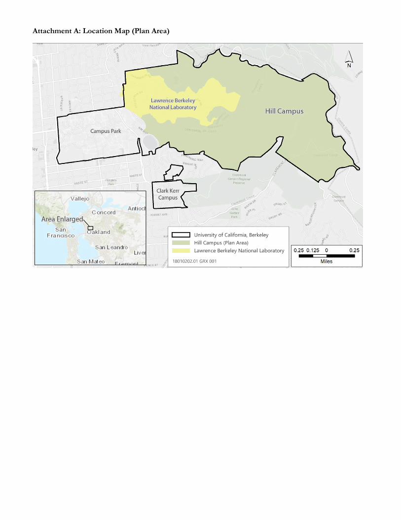
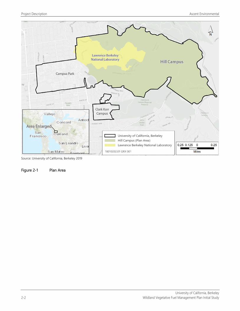
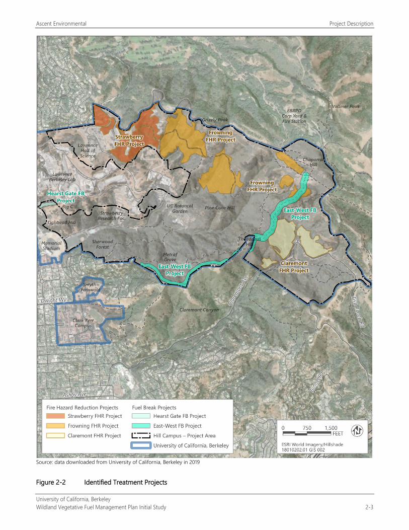

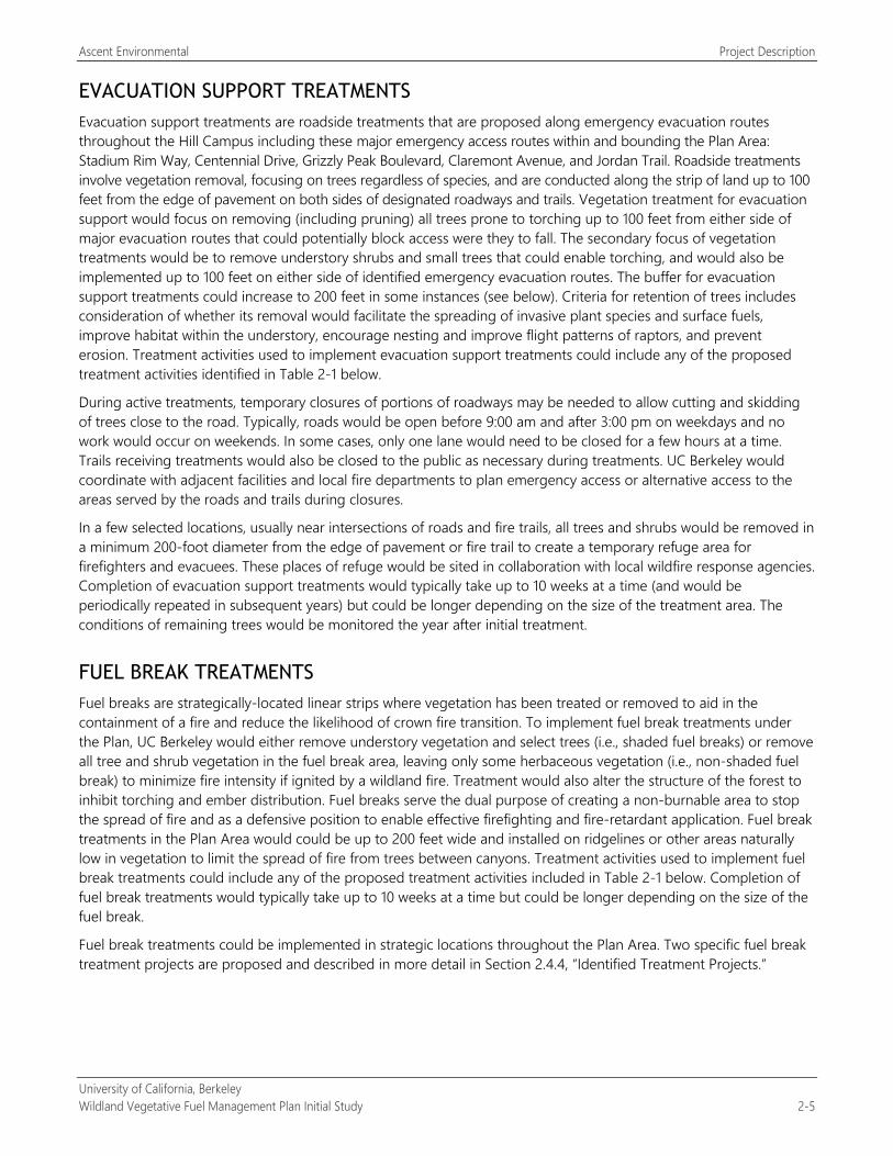
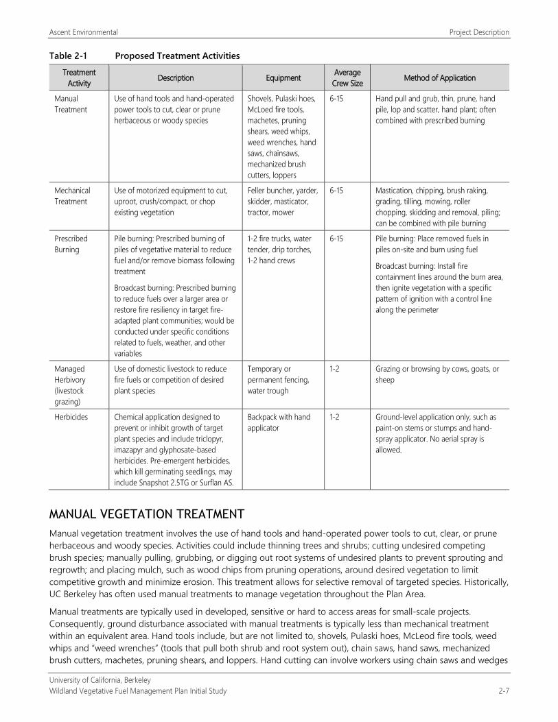
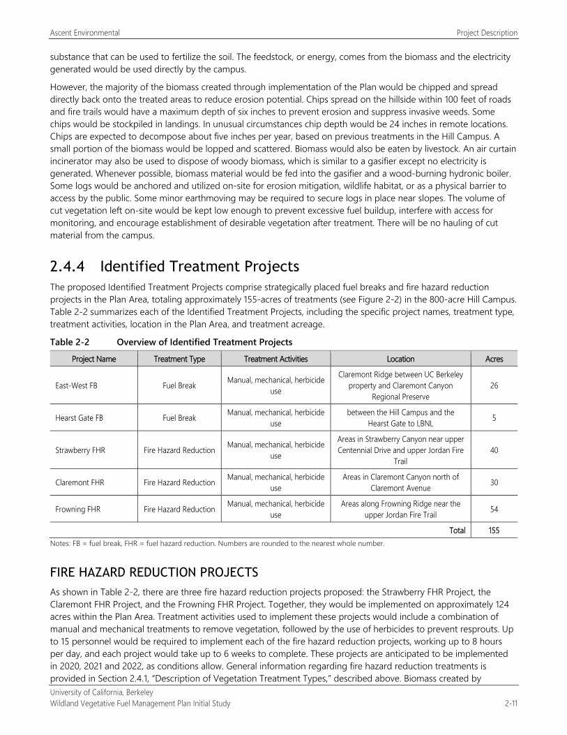

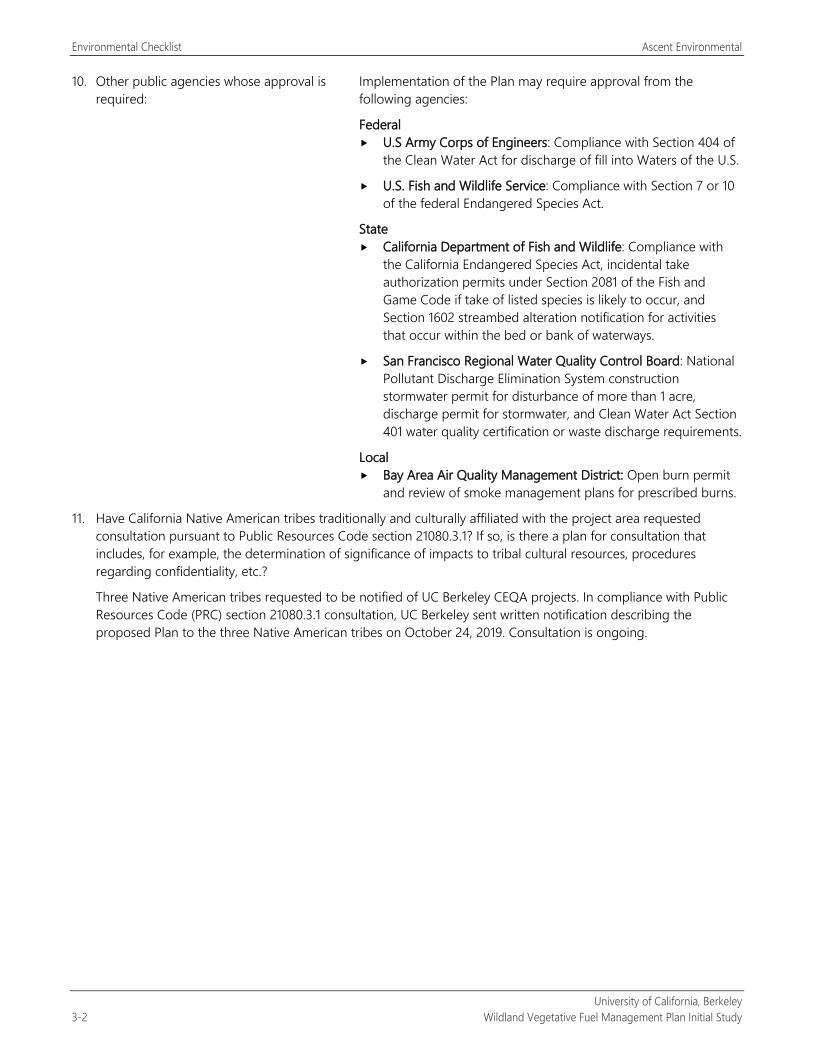
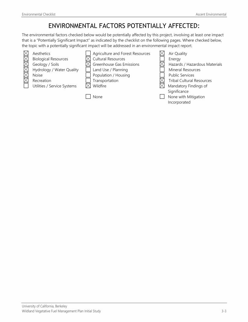
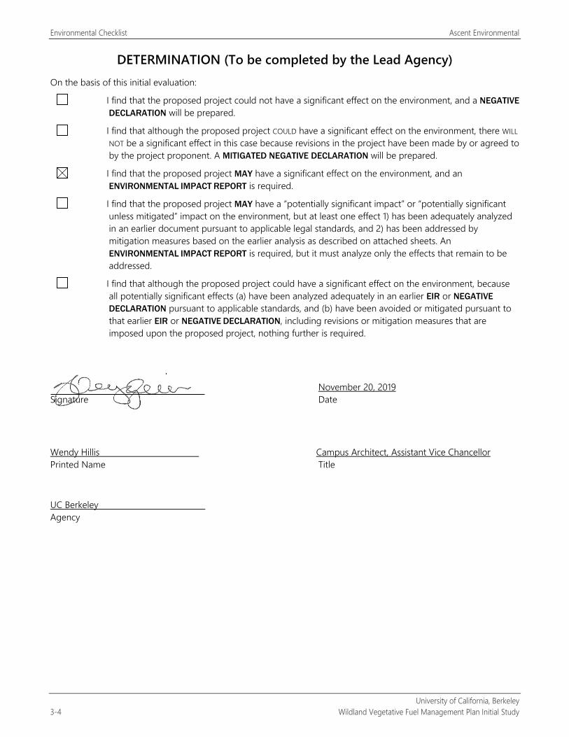
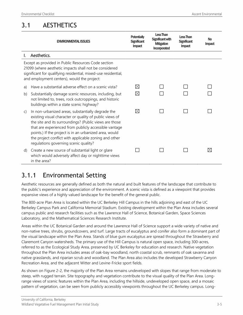
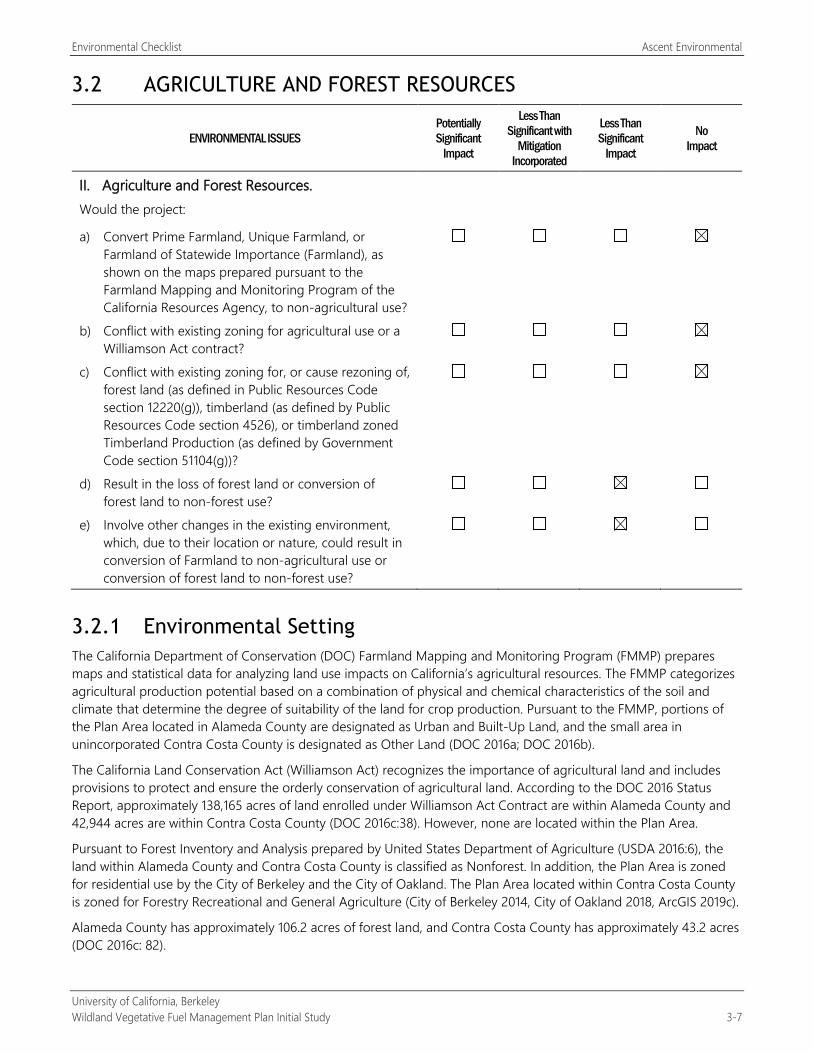
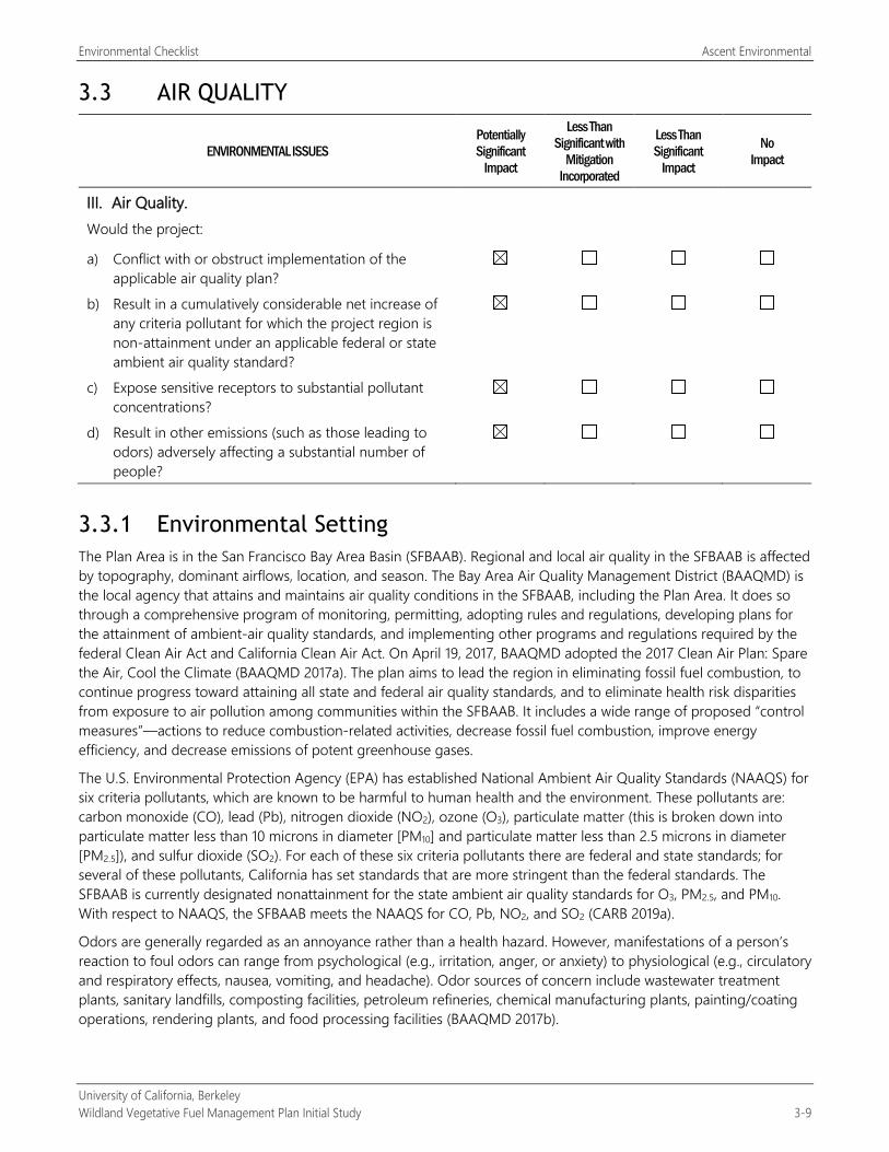
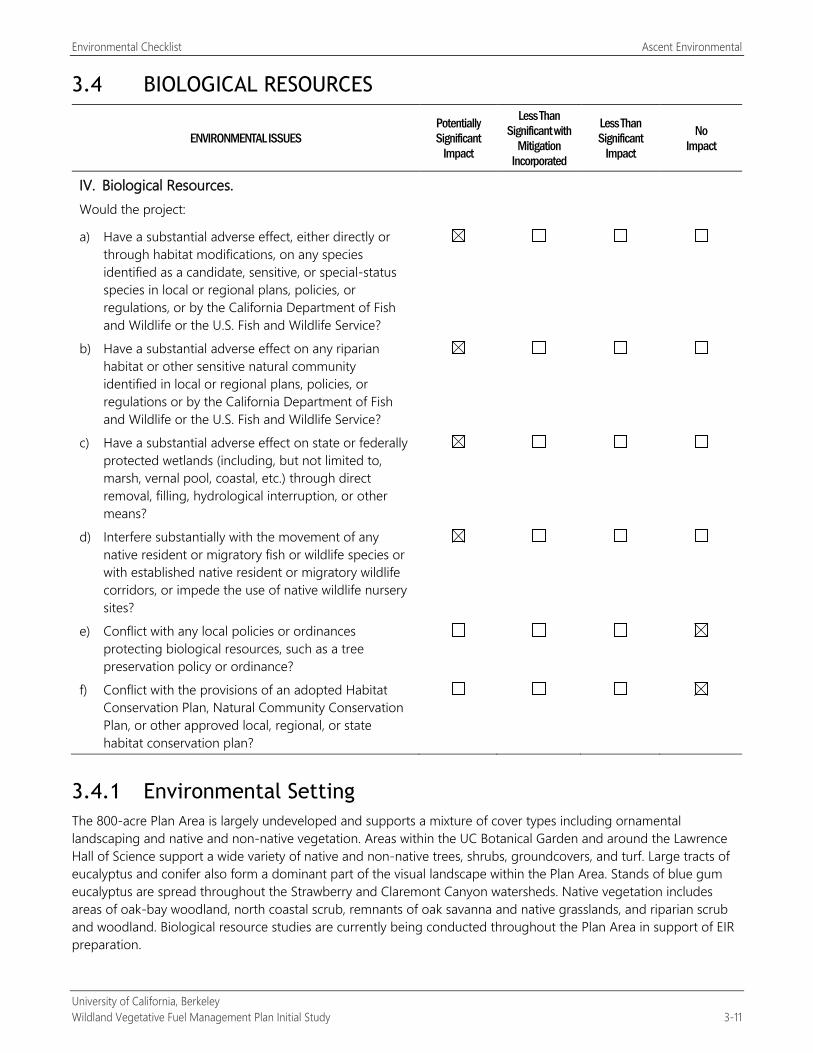
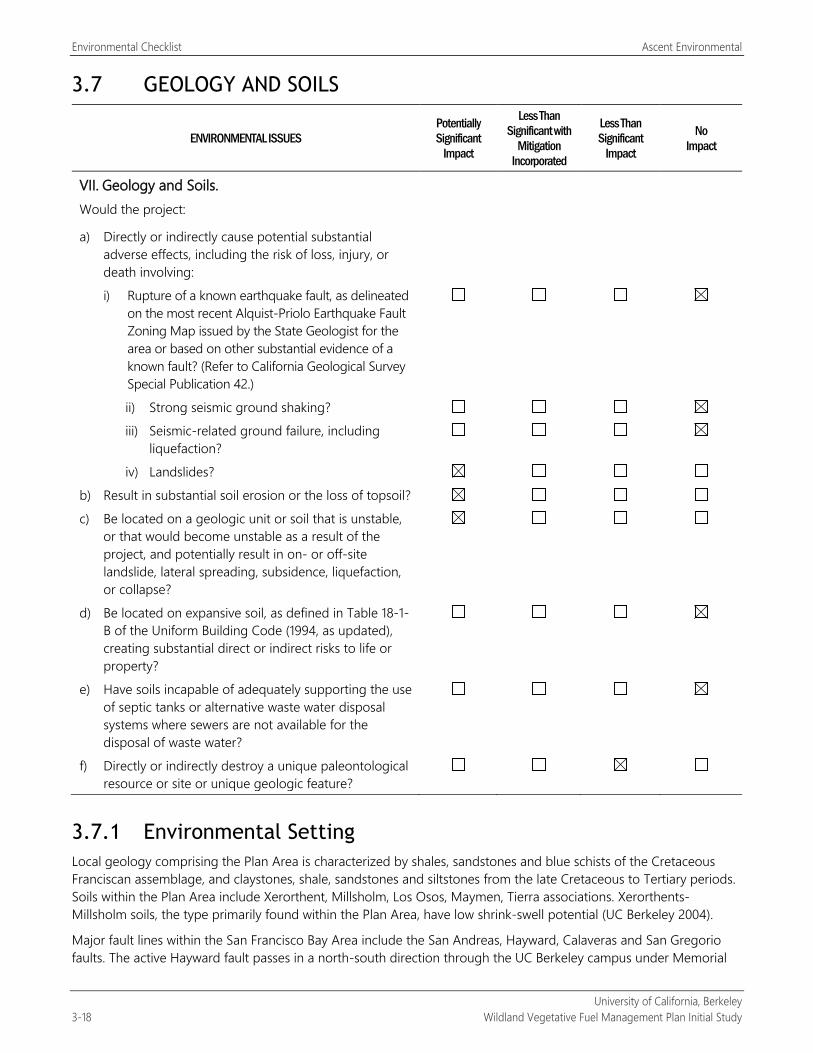
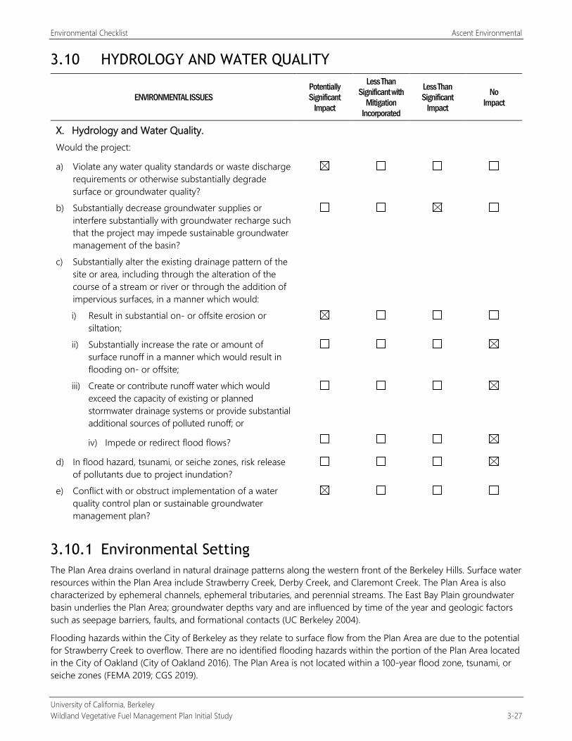
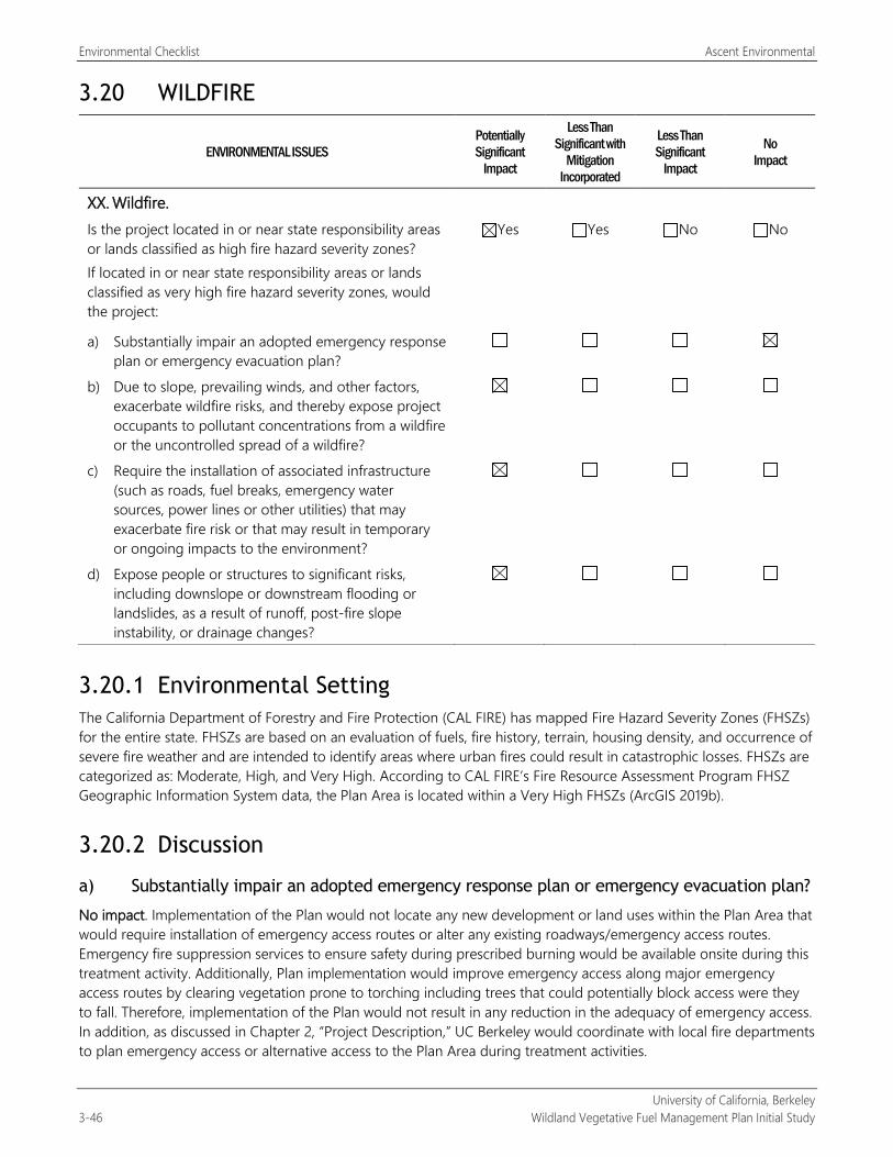
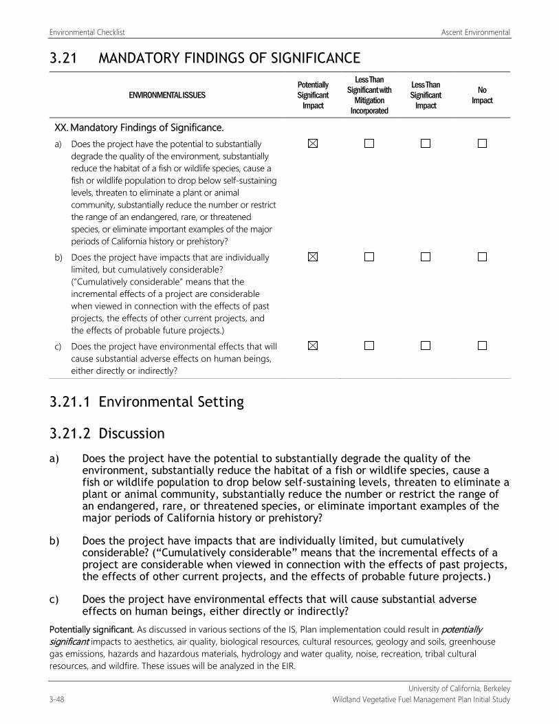


![Kiran S. Kedlaya arXiv:math/0110124v4 [math.AG] 1 …Kiran S. Kedlaya Department of Mathematics University of California, Berkeley Berkeley, CA 94720 kedlaya@math.berkeley.edu December](https://static.documents.pub/doc/80x56/5fc4ba41e6dafe638a2d04a2/kiran-s-kedlaya-arxivmath0110124v4-mathag-1-kiran-s-kedlaya-department-of.jpg)


