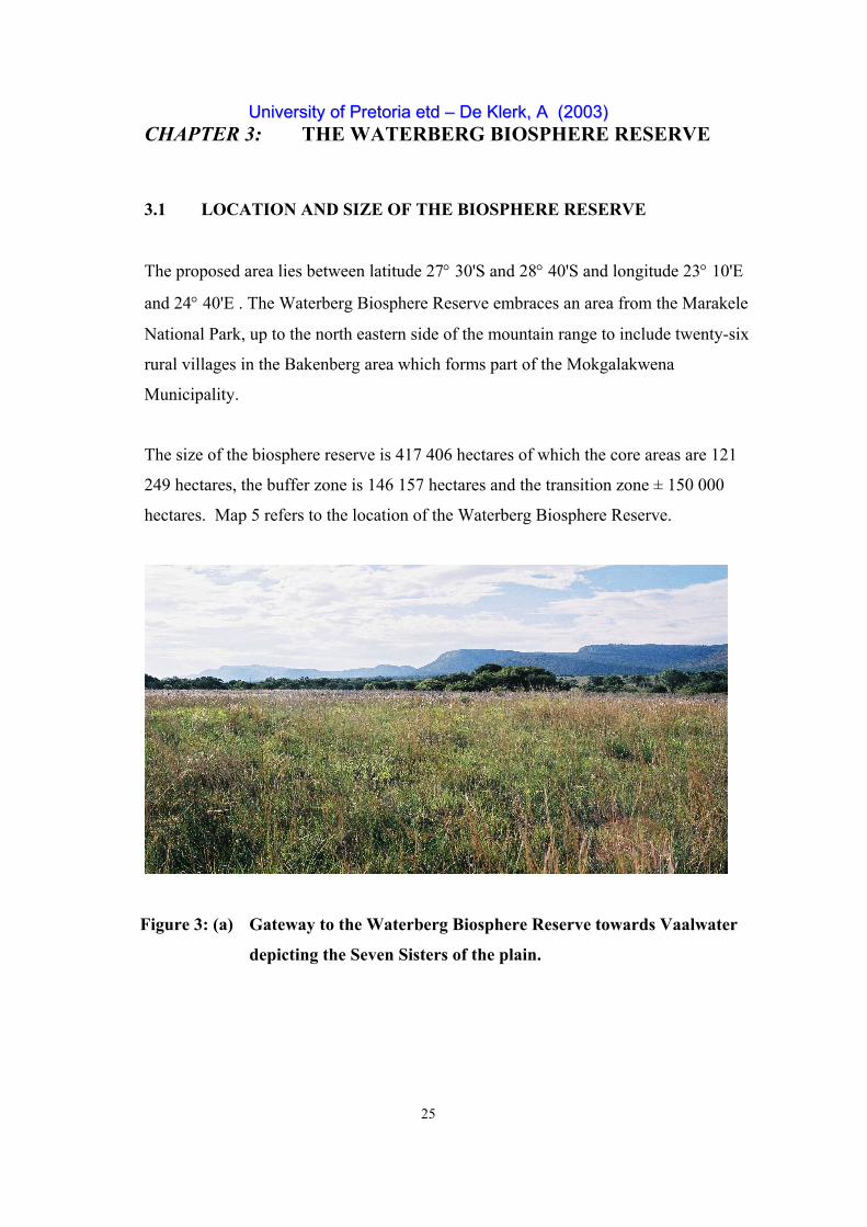
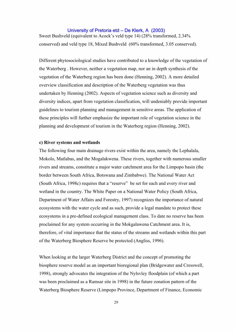
University of Pretoria etd – De Klerk, A (2003) 25 CHAPTER 3: THE WATERBERG BIOSPHERE RESERVE 3.1 LOCATION AND SIZE OF THE BIOSPHERE RESERVE The proposed area lies between latitude 27° 30'S and 28° 40'S and longitude 23° 10'E and 24° 40'E . The Waterberg Biosphere Reserve embraces an area from the Marakele National Park, up to the north eastern side of the mountain range to include twenty-six rural villages in the Bakenberg area which forms part of the Mokgalakwena Municipality. The size of the biosphere reserve is 417 406 hectares of which the core areas are 121 249 hectares, the buffer zone is 146 157 hectares and the transition zone ± 150 000 hectares. Map 5 refers to the location of the Waterberg Biosphere Reserve. Figure 3: (a) Gateway to the Waterberg Biosphere Reserve towards Vaalwater depicting the Seven Sisters of the plain.
Transcript
UUnniivveerrssiittyy ooff PPrreettoorriiaa eettdd –– DDee KKlleerrkk,, AA ((22000033))
25
CHAPTER 3: THE WATERBERG BIOSPHERE RESERVE
3.1 LOCATION AND SIZE OF THE BIOSPHERE RESERVE
The proposed area lies between latitude 27° 30'S and 28° 40'S and longitude 23° 10'E
and 24° 40'E . The Waterberg Biosphere Reserve embraces an area from the Marakele
National Park, up to the north eastern side of the mountain range to include twenty-six
rural villages in the Bakenberg area which forms part of the Mokgalakwena
Municipality.
The size of the biosphere reserve is 417 406 hectares of which the core areas are 121
249 hectares, the buffer zone is 146 157 hectares and the transition zone ± 150 000
hectares. Map 5 refers to the location of the Waterberg Biosphere Reserve.
Figure 3: (a) Gateway to the Waterberg Biosphere Reserve towards Vaalwater
depicting the Seven Sisters of the plain.
UUnniivveerrssiittyy ooff PPrreettoorriiaa eettdd –– DDee KKlleerrkk,, AA ((22000033))
26
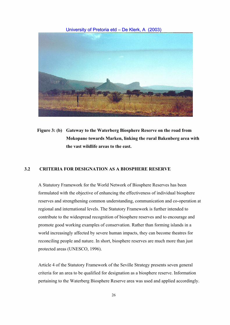
Figure 3: (b) Gateway to the Waterberg Biosphere Reserve on the road from
Mokopane towards Marken, linking the rural Bakenberg area with
the vast wildlife areas to the east.
3.2 CRITERIA FOR DESIGNATION AS A BIOSPHERE RESERVE
A Statutory Framework for the World Network of Biosphere Reserves has been
formulated with the objective of enhancing the effectiveness of individual biosphere
reserves and strengthening common understanding, communication and co-operation at
regional and international levels. The Statutory Framework is further intended to
contribute to the widespread recognition of biosphere reserves and to encourage and
promote good working examples of conservation. Rather than forming islands in a
world increasingly affected by severe human impacts, they can become theatres for
reconciling people and nature. In short, biosphere reserves are much more than just
protected areas (UNESCO, 1996).
Article 4 of the Statutory Framework of the Seville Strategy presents seven general
criteria for an area to be qualified for designation as a biosphere reserve. Information
pertaining to the Waterberg Biosphere Reserve area was used and applied accordingly.
UUnniivveerrssiittyy ooff PPrreettoorriiaa eettdd –– DDee KKlleerrkk,, AA ((22000033))
27
3.2.1 Criterium1: The area should encompass a mosaic of ecological
systems representative of major biogeographic regions, including a
gradation of human intervention
a) Topography
The most noticeable topographic feature of the biosphere reserve is the Waterberg
Mountain range. The elevation of the range above sea level within the Waterberg
Biosphere Reserve area varies between 807,7 meters (lowest point) in Wonderkop
Nature Reserve (De Klerk and Loubser, 1989) and 2 100 meters (highest) in Marakele
National Park (Van Staden, 2002). The mountainous area of the Waterberg forms a
large plateau with steep escarpments to the south and east. The mountain range has
predominantly sandstone hills and mountains. The area receives between 650 and
900 mm of rain annually (Van Rooyen and Bredenkamp, 1996). It is characterized by
numerous streams and small rivers, rock-pools, deep and large pools in the stream and
river beds, fountains, marshes, and other features associated with the high rainfall on the
rocky areas of the mountains. The bare and beautiful sandstone cliffs so typical of the
Waterberg mountains and other adjacent hills or koppies can be described as a major
characterizing feature of the biosphere reserve as well.
b) Vegetation
The World Network of Biosphere Reserve Map classifies the vegetation of the area as
savanna. The Waterberg Biosphere Reserve represents a considerable area of the
savanna biome of Southern Africa. Although the conservation status of savanna is in
principle good, less than 5% of the biome is formally protected (Rutherford and
Westfall, 1986). Savanna vegetation types are inadequately conserved within formally
proclaimed nature reserves.
According to Acocks (1988), there are five different veld types represented in the
biosphere reserve, of which the most common are Sour Bushveld (veld type 20) and
Mixed Bushveld (veld type 18), typical savanna vegetation types. To the north there is
also a small component of Acock’s veld type 14 (Arid Sweet Bushveld). A number of
UUnniivveerrssiittyy ooff PPrreettoorriiaa eettdd –– DDee KKlleerrkk,, AA ((22000033))
28
smaller areas to the south and centrally on the highest parts of the Waterberg are
covered by one of the most threatened veld types in the Limpopo Province, namely veld
type 8 (North-Eastern Mountain Sourveld). In the extreme south veld type 19 (Sourish
Mixed Bushveld) occurs to a limited extent. The clear gradient in the vegetation, from
sour in the south and on high elevations, to sweet in the north on lower elevations, is
linked to the variation in annual precipitation as determined by elevation and latitude
(more moist to the south, drier to the north).
The Waterberg has the largest portion of the Sour Bushveld veld type, which
characterizes mountainous savanna areas. A large diversity of habitat types can be found
in the Waterberg plateau, valleys, cliffs, and slopes (Henning, 2002). Deep sandy soils
alternated by shallow and rocky soils occur on the flats and plateau, while in the valleys
the vegetation changes from riparian vegetation (amongst others riparian woodlands and
near-forests, reed beds and marshes/vleis) to the predominantly thornveld on the loamy
alluvial valley floors. The grassveld is particularly rich floristically, while the woody
component is divers. Apart from the termitaria patches on the slopes, where near-forests
develop, there is a great wealth of forbs and bushy plants, including stragglers of the
southern (fynbos) flora. The savanna biome is home to a wide variety of large
herbivores, which, together with fire, play a decisive role in ecosystem processes, and
the maintenance of plant species diversity (Henning, 2002).
The Mixed Bushveld veld type is found at lower elevations than the Sour Bushveld, and
occurs as a maze of variations and transitions. They vary from rather dense short
savanna to tall, sparser savanna, and generally provide better grazing to the large
herbivores than the Sour Bushveld.
According to another South African veld type classification, that of Low and Rebelo
(1996), the Waterberg Biosphere Reserve is mostly covered by veld type 12, Waterberg
Moist Mountain Bushveld (equivalent to Acock’s veld type 20). In 1996, about 28% of
this veld type had been transformed by human activities, while 8.55% had been
conserved. The rest of the Waterberg Biosphere Reserve consists of veld types 17,
UUnniivveerrssiittyy ooff PPrreettoorriiaa eettdd –– DDee KKlleerrkk,, AA ((22000033))
29
Sweet Bushveld (equivalent to Acock’s veld type 14) (28% transformed, 2.34%
conserved) and veld type 18, Mixed Bushveld (60% transformed, 3.05 conserved).
Different phytosociological studies have contributed to a knowledge of the vegetation of
the Waterberg . However, neither a vegetation map, nor an in depth synthesis of the
vegetation of the Waterberg region has been done (Henning, 2002). A more detailed
overview classification and description of the Waterberg vegetation was thus
undertaken by Henning (2002). Aspects of vegetation science such as diversity and
diversity indices, apart from vegetation classification, will undeniably provide important
guidelines to tourism planning and management in sensitive areas. The application of
these principles will further emphasize the important role of vegetation science in the
planning and development of tourism in the Waterberg region (Henning, 2002).
c) River systems and wetlands
The following four main drainage rivers exist within the area, namely the Lephalala,
Mokolo, Matlabas, and the Mogalakwena. These rivers, together with numerous smaller
rivers and streams, constitute a major water catchment area for the Limpopo basin (the
border between South Africa, Botswana and Zimbabwe). The National Water Act
(South Africa, 1998c) requires that a “reserve” be set for each and every river and
wetland in the country. The White Paper on a National Water Policy (South Africa,
Department of Water Affairs and Forestry, 1997) recognizes the importance of natural
ecosystems with the water cycle and as such, provide a legal mandate to protect these
ecosystems in a pre-defined ecological management class. To date no reserve has been
proclaimed for any system occurring in the Mokgalawena Catchment area. It is,
therefore, of vital importance that the status of the streams and wetlands within this part
of the Waterberg Biosphere Reserve be protected (Angliss, 1996).
When looking at the larger Waterberg District and the concept of promoting the
biosphere reserve model as an important bioregional plan (Bridgewater and Cresswell,
1998), strongly advocates the integration of the Nylsvley floodplain (of which a part
was been proclaimed as a Ramsar site in 1998) in the future zonation pattern of the
Waterberg Biosphere Reserve (Limpopo Province, Department of Finance, Economic
UUnniivveerrssiittyy ooff PPrreettoorriiaa eettdd –– DDee KKlleerrkk,, AA ((22000033))
30
Affairs and Tourism, 2001).
The Nyl River floodplain stretches for 67 km between Middelfontein (east of
Modimole) and Moordrift (south of Mookgopong) in the Limpopo Province. It is up to
6 km wide in places and has been described as the largest inland floodplain in South
Africa (Noble and Hemens, 1978). The seven attributes, which drain into the Nyl River,
are situated in the foothills of the Waterberg Mountains while the Nyl River floodplain
occupies almost one third of the catchment area of the Nyl River system, which
converges into the Mokgalakwena River to finally form part of the larger Limpopo
River basin ( Frost, 1987). Currently only 4% of the floodplain area is under official
protection, namely the pat that falls within the Nylsvley Nature Reserve.
Wetlands play an important hydrological and ecological role, because they performing a
number of functions, such as water storage, stream flow regulation, flood attenuation,
water purification, nutrient assimilation, sediment accretion, and the provision of habitat
for a wide variety of plant and animal species (Begg, 1986). The inclusion of the Nyl
River floodplain into the zonation of the Waterberg Biosphere Reserve will thus
certainly add to the reserve’s conservation status.
d) Geology
The main mass of the Waterberg consists of sedimentary rock, and is bounded by
escarpments on the north, east and south with the central portion forming the Palala
Plateau. These sediments are entirely detritus and consist of sandstones, mudstones,
shales, conglomerates, and lenses of grits (Truswell, 1977; SACS, 1980). However, the
Waterberg Group of Sandstone is almost entirely limited to the Waterberg Biosphere
Reserve.
The Bushveld Igneous Complex, the bedrock of the Waterberg mountains, was formed
1,954 ± 30 million years ago while the Waterberg System or Super Group was formed
some 1 790 million years ago following an extensive period of levelling due to the
erosion of the Bushveld Igneous Complex (Truswell, 1977; SACS, 1980).
UUnniivveerrssiittyy ooff PPrreettoorriiaa eettdd –– DDee KKlleerrkk,, AA ((22000033))
31
E) Soil
Due to the domination of quartzitic sandstone, the nature of the soil is predominantly
sandy. Sandy soils are very leached due to the relatively high rainfall and are, therefore,
mostly of a distrophic nature. As a result of the predominantly hilly and mountainous
nature of the terrain, a large portion of the soils are very shallow and rocky (Low and
Rebello, 1996), and can therefore be classified according to the South African soil
classification system of McVicar et al. (1977) as being of the Glenrosa and Mispah soil
forms. Dominant soils found on the flat areas such as the plateau and lower lying plains
are of the Clovelly and Avalon forms. Although these soil forms are also found in the
valleys and drainage lines, other soil forms with a higher clay and nutrient content and
generally with a better developed structure are more common. The following soil forms
frequently occur in theses landscapes: Hutton, Dundee, Oakleaf, Katspruit, Westleigh,
Champagne, Cartref, Inanda, Kranskop, Magwa, Griffin, Longlands, and Fernwood
(Land Type Survey Staff, 1988).
f) Human interventions
The current human communities in the Waterberg Biosphere Reserve consist mainly of
white farmers and black rural, mainly Pedi speaking people. The town Vaalwater has a
small, mixed ethnic population.
The Waterberg has a long history of human occupation and has been inhabited by a
succession of people over hundreds of thousands of years. If we include the remains of
the early Hominids, its history spans more than a million years. Excavations at the
Olieboompoort Shelter in the north-western part of the Waterberg have yielded tools
which display a large degree of specialisation and skill in stoneworking, and are
representative of the Middle Stone Age (Woodhouse, 1987). The people of the Late
Stone Age included the San (Bushmen), who were indigenous hunter gatherers, as well
as Khoikhoi herders who came from Eastern Africa with their sheep, cattle and goats,
and preferred the wetter coastal areas. Some material remains of the Khoikhoi may be
found on the inland plateau (Palala), since they may even have passed through the
Waterberg, where paintings of fat-tailed sheep occur. Within the last two thousand
years, however, the San were displaced when the first Iron Age people moved into the
UUnniivveerrssiittyy ooff PPrreettoorriiaa eettdd –– DDee KKlleerrkk,, AA ((22000033))
32
area (Van der Ryst,1996). These people owned cattle and practised subsistence farming
on the deep red soils which surface along the river valleys.
It was at this time that the Agro Pastoralists from the lowlands moved into the
Waterberg. Auckema (1991) is of the opinion that this move was prompted by the
spread of tsetse fly into the lowveld areas where these early farmers had lived for
centuries.
Their farming were successful and their cattle herds increased on the sweetveld. This
caused overgrazing and resulted in encroachment by pioneer thorn bush, a suitable
habitat for tsetse flies. According to Auckema (1991), the Waterberg Plateau was also
inhabited by another group, who were Nguni speaking and who selected hilltop sites for
settlement. These settlements may have been built by the ancestors of the Northern
Transvaal Ndebele, who now live further east. Boersema (1996) states that these
Northern Ndebele people have lived in the Mokopane (Potgietersrus) area since
approximately 1750. Also of Northern Ndebele origin are the Langa of Mapela and
Bakenberg. These facts concerning human history are important for the current study
because Khosi Langa of Bakenberg is currently the traditional representative of the rural
communities which are involved in the Waterberg Biosphere Reserve (Boersema,
1996).
The remote and inaccessible Waterberg was one of the last regions in the geographical
area formerly known as the Transvaal to be permanently occupied by white farmers
(Van der Ryst, 1996). Although the first Voortrekker farmers moved into the Waterberg
during the 1850s, the region has been increasingly occupied on a regular basis only
since the early part of the twentieth century (Van der Ryst, 1996).
The Waterberg area was predominantly used for seasonal game hunting or cattle
pasturage. According to historical sources and local oral tradition hunter-gatherers had
been living in the region until after the turn of the century. Hunter-gatherers have
consequently been in contact with black and white farmers in the Waterberg till
recently. According to Van der Ryst (1996), archaeological evidence for social and
economic change at the Later Stone Age sites has been linked to the above mentioned
UUnniivveerrssiittyy ooff PPrreettoorriiaa eettdd –– DDee KKlleerrkk,, AA ((22000033))
33
contact period. Given our knowledge of the human occupation of the Waterberg, it
nevertheless appears to have been unoccupied for many thousands of years, an aspect
that will continue to intrigue archaeologists. Part of the complexity and fascination of
the Waterberg history, nevertheless, lies in the interaction of the culturally diverse
groups who have been living here during the last couple of centuries (Van der Ryst,
1996).
g) Current human activities
Human interventions are part and parcel of the history of the Waterberg area. A
considerable area of land has been altered by human activities, of which commercial
and subsistence crop cultivation is the most important human activity in this regard. In
the past commercial dryland cultivation was extensively applied to the land, but because
of its erratic rainfall and the nutrient poor soils of the area this practice has decreased
considerably. A fair number of old abandoned fields in varying degrees of recovery thus
still exist. Currently, however, commercial irrigated cultivation, especially alongside the
river courses in the Waterberg, is the most extensive ongoing land use practice and
account for positive alterations to the vegetation. To a lesser, but still considerable
extent, is the effect of subsistence crop farming, as well as overgrazing by cattle or
game with resulting vegetation changes. The growing tourism and hunting industry also
influences current human activities. Map 3 thus indicates the distribution of exemption
farms in the area. In addition, the infrastructure, like roads and lodges is constantly
changed that the influx of tourists to the region could cause concern if not probably
managed (UNEP/CBD, 2002).
The current influence of infrastructure in the Waterberg Biosphere Reserve, for instance
the development of towns, villages and roads with their associated impact, is not as
extensive as the other land uses e.g. mining and irrigation, which impact is both drastic
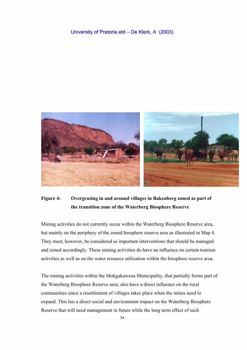
and irreversible. There is also a clear indication that the impact of overgrazing is more
severe around the villages (as Figure 4 illustrates), while erosion, both sheet and donga,
occurs mainly around these rural human settlements (De Klerk, 2001).
UUnniivveerrssiittyy ooff PPrreettoorriiaa eettdd –– DDee KKlleerrkk,, AA ((22000033))
34
Figure 4: Overgrazing in and around villages in Bakenberg zoned as part of
the transition zone of the Waterberg Biosphere Reserve
Mining activities do not currently occur within the Waterberg Biosphere Reserve area,
but mainly on the periphery of the zoned biosphere reserve area as illustrated in Map 4.
They must, however, be considered as important interventions that should be managed
and zoned accordingly. These mining activities do have an influence on certain tourism
activities as well as on the water resource utilization within the biosphere reserve area.
The mining activities within the Mokgakawena Municipality, that partially forms part of
the Waterberg Biosphere Reserve area, also have a direct influence on the rural
communities since a resettlement of villages takes place when the mines need to
expand. This has a direct social and environment impact on the Waterberg Biosphere
Reserve that will need management in future while the long term effect of such
UUnniivveerrssiittyy ooff PPrreettoorriiaa eettdd –– DDee KKlleerrkk,, AA ((22000033))
35
resettlements could influence the land use zonation plans of the municipalities and the
biosphere reserve itself.
3.2.2 Criterium 2: Be of significance for biological diversity conservation
Taking the general information provided under Criterium 1 into account, the following
features could be identified as being significant features within the Waterberg Biosphere
Reserve.
a) Sandstone features
The sandstone, shale and conglomerate rocks of the range are rather unique to this area.
The occurrence of the geological formation that underlies the area, namely the
Waterberg Group of Sandstone, is almost entirely limited to the Waterberg Biosphere
Reserve.
Foto: Department of Finance, Economic Affairs and Tourism
Figure 5: Sandstone features at Masebe Nature Reserve, unique to the Waterberg
b) Species
Of significance for the development of tourism and game farming are the reintroduction
of a number of game species as depicted in the rock paintings in the Waterberg.
According to Van der Ryst (1996) these include Eland (Taurotragus oryx), Elephant
(Loxodonta africana), Kudu (Tragelaphus stresiceros), Giraffe (Giraffa
UUnniivveerrssiittyy ooff PPrreettoorriiaa eettdd –– DDee KKlleerrkk,, AA ((22000033))
36
cameleopardalis), Reedbuck (Redunca sp), carnivores, and reptiles.
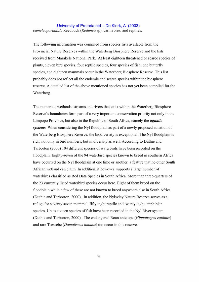
The following information was compiled from species lists available from the
Provincial Nature Reserves within the Waterberg Biosphere Reserve and the lists
received from Marakele National Park. At least eighteen threatened or scarce species of
plants, eleven bird species, four reptile species, four species of fish, one butterfly
species, and eighteen mammals occur in the Waterberg Biosphere Reserve. This list
probably does not reflect all the endemic and scarce species within the biosphere
reserve. A detailed list of the above mentioned species has not yet been compiled for the
Waterberg.
The numerous wetlands, streams and rivers that exist within the Waterberg Biosphere
Reserve’s boundaries form part of a very important conservation priority not only in the
Limpopo Province, but also in the Republic of South Africa, namely the aquatic
systems. When considering the Nyl floodplain as part of a newly proposed zonation of
the Waterberg Biosphere Reserve, the biodiversity is exceptional. The Nyl floodplain is
rich, not only in bird numbers, but in diversity as well. According to Duthie and
Tarborton (2000) 104 different species of waterbirds have been recorded on the
floodplain. Eighty-seven of the 94 waterbird species known to breed in southern Africa
have occurred on the Nyl floodplain at one time or another, a feature that no other South
African wetland can claim. In addition, it however supports a large number of
waterbirds classified as Red Data Species in South Africa. More than three-quarters of
the 23 currently listed waterbird species occur here. Eight of them breed on the
floodplain while a few of these are not known to breed anywhere else in South Africa
(Duthie and Tarborton, 2000). In addition, the Nylsvley Nature Reserve serves as a
refuge for seventy seven mammal, fifty eight reptile and twenty eight amphibian
species. Up to sixteen species of fish have been recorded in the Nyl River system
(Duthie and Tarborton, 2000) . The endangered Roan antelope (Hippotragus equinux)
and rare Tsessebe (Damaliscus lunatus) too occur in this reserve.
UUnniivveerrssiittyy ooff PPrreettoorriiaa eettdd –– DDee KKlleerrkk,, AA ((22000033))
37
c) Veldtypes
The Waterberg Moist Mountain Bushveld (Low and Rebelo, 1996) which is
synonymous to Acocks’s (1988) Sour Bushveld is largely limited to the Waterberg
mountains, with the Waterberg Biosphere Reserve including the majority of this veld
type. Bredenkamp and van Rooyen (1996) also indicate the economic uses in this veld
type as game and cattle farming as well as ecotourism.
Phytosociological studies contributing to the vegetation knowledge of the Waterberg
Moist Mountain Bushveld (Coetzee et al1.,1977; Westfall et al.,1985) and the recent
study of Henning (2002) stress the importance in conserving this veldtype, not only
through the legal proclamation of establishing protected areas but also through proper
planning and management in relation to its utilization e.g. tourism. This, therefore,
reinforces the fact that the Waterberg Biosphere Reserve has a significant conservation
role to play in this regard. Map 8 indicates the veldtypes which occur in the Waterberg
Biosphere Reserve area according to Acocks (1988).
d) Unique land use practices
The fact that the land use has changed over the last 21 years (Walker,1998) from crop
and irrigation practices to cattle and game farming indicates a natural tendency to utilize
the natural resources of the Waterberg optimally. The dry seasons also contributed to
these changes. The vast open spaces currently under conservation/game
farming/ecotourism are, nevertheless, significant in themselves since one does not easily
find natural areas of this size in other parts of South Africa. As already mentioned in
Chapter 2, the Waterberg has the lowest human population density in the Province
mainly due to the large farming community. The majority of villages are found to the
north-eastern side of the Waterberg Biosphere Reserve as indicated on Maps 4 and 6.
Under the dispensation of the previous government, this north-eastern area was formally
part of the Lebowa homeland and its inhabitants have been mainly cattle and
subsistence farmers who are still practising the same land uses. The only difference
today is the expansion of villages. It must, however, be noted that the lack of water in
the area hampers large developments. The influx of people would rather settle close to
the town of Mokopane. It must, however, be noted that the villagers within the zoned
UUnniivveerrssiittyy ooff PPrreettoorriiaa eettdd –– DDee KKlleerrkk,, AA ((22000033))
38
Waterberg Biosphere Reserve area are still conducting dry land cultivation in the
traditional way cultivating family plots, a feature that makes the area unique. Within the
Waterberg Biosphere Reserve framework these traditional systems are thus extremely
useful for conserving ancient breeds of livestock, and old land races of crops, which are
invaluable gene pools for modern agriculture (UNESCO, 1995)
e) Rock Art
Numerous paintings of people in trance positions, dance scenes of men and women,
men with hunting equipment, a large variety of antelope and other animals, imaginary
rain animals, handprints, and geometric designs form part of the contents of the rock art
of the Waterberg (Van der Ryst , 1996). In conversations with landowners while
conducting the fieldwork for this study, it became evident that the Waterberg is rapidly
emerging as a rock art area. Almost all the landowners indicated that there is some form
of rock art or archaeological artefacts on their properties. Many, if not most of these are
still undiscovered and have certainly not been described. Of special significance is the
area along the steep gorges of the Lephalala River as described by Woodhouse (1987)
and the rock shelter at Masebe Nature Reserve, which represents one of the larger Stone
Age shelters yet identified in the Waterberg (Boeyens et al., 1996).
Two traditions of Rock Art occur in the Waterberg. First the more “naturalised” form of
art, which includes skilled depictions of animals and people and is attributed to the San
and is closely linked to Shamanism. Second, the more geometric, schematic art
tradition, which includes the so-called “late white” paintings, and finger painting is
found. This tradition is associated with negroid farmers who painted for different
reasons. The San people further possessed powers of healing, rainmaking and control of
animal movements, all of which we find depicted in San Art (Van der Ryst, 1996).
3.2.3 Criterium 3: Provide an opportunity to explore and demonstrate
approaches to sustainable development on a regional scale.
At an operational level sustainable development has four interlinked dimensions namely
economic, environmental, social, and cultural. (UNESCO, 2002). However, sustainable
UUnniivveerrssiittyy ooff PPrreettoorriiaa eettdd –– DDee KKlleerrkk,, AA ((22000033))
39
development can have a working sense only when these four dimensions of
development are of equal importance and strength. No one country or region has
reached an acceptable dynamic balance of the four legs. In the late 1970s and early
1980s, the conservation role had been kept prominent in the designation of the vast
majority of biosphere reserves (Batisse, 1986) with the environmental dimension as
referred to above as the main focus. However, in November 1995, the UNESCO
General Conference approved the Seville Strategy for Biosphere Reserves and adopted
the Statutory Framework of the World Network, which define the principles, the criteria
and the designation procedure for biosphere reserves (UNESCO,1996). With these
documents the philosophy and concepts underpinning biosphere reserves have
continued to spread into the broader international context, so that protected areas are
being considered as integral to socio-economic development.
Biosphere reserves are increasingly regarded as practical examples of where the
conservation and development roles are integrated (UNESCO, 2001).
All too often conservation programmes focus on areas that are too small to meet the
habitat requirements of all species. In addition, conservation and resource management
goals are often too narrowly formulated to make either economic or biological sense.
However, biosphere reserves provide frameworks for practising biodiversity
conservation and resource management on a larger scale.
The Waterberg Biosphere Reserve represents the savanna biome that extends into the
Limpopo Province’s and South Africa’s neighbouring countries namely Botswana,
Zimbabwe and Namibia (Low and Rebelo, 1996). The two ecosystem types, namely
Tropical Dry or Deciduous Forest and Tropical Grasslands and Savanna, as indicated on
the map of the World network of Biosphere reserves, are found in this eco-region which
flows over into Zimbabwe, Botswana and Mozambique. As such, the Waterberg
Biosphere Reserve would be an ideal pilot site that represents the savanna biome on a
regional scale.
UUnniivveerrssiittyy ooff PPrreettoorriiaa eettdd –– DDee KKlleerrkk,, AA ((22000033))
40
Since tourism is one of the fastest growing industries in the world (World Tourism
Organization, 2002), the Limpopo Province capitalized on this tendency, by identifying
tourism as one of the economic pillars that need to be developed as a priority. The two
transborder initiatives, namely the Mapungubwe and Greater Limpopo, are currently
engaged in unlocking the Province’s tourism potential as well as those of its
neighbouring countries. The Waterberg Biosphere Reserve has thus been identified as
one of the provincial building blocks of the Golden Horseshoe that links with the two
transborder initiatives.
The Waterberg Biosphere Reserve is therefore positioned in a way that provides an
opportunity to demonstrate sustainable development on a regional scale. This aspect
will be discussed in more detail in Chapter 4.
3.2.4 Criterium 4: Have an appropriate size to serve the three functions of
biosphere reserves
In combining the three functions of biosphere reserves, these reserves should strive to
be sites of excellence for exploring and demonstrating approaches to conservation and
sustainable development, as referred to in Article 3 of the Statutory Framework
(UNESCO, 1996; UNESCO, 2000). To accomplish this goal a biosphere reserve must
have an appropriate size to serve the three functions.
The Waterberg Biosphere Reserve is currently ± 414 571 hectares in size, of which the
five core areas are 114 571 hectares, the buffer zone 150 000 hectares and the transition
also ± 150 000 hectares.
It must, however, be clearly stated that the Waterberg Biosphere Reserve’s boundary
was identified according to a participation process with all the relevant stakeholders at
the time when the nomination form was completed. During the negotiation process it
UUnniivveerrssiittyy ooff PPrreettoorriiaa eettdd –– DDee KKlleerrkk,, AA ((22000033))
41
was agreed that the Waterberg Biosphere Reserve’s boundary must not be seen as cast
in stone but that the zonation pattern would be re-investigated in future.
Two additional core areas within the Waterberg District that need to be incorporated
into the new zonation pattern of the Waterberg Biosphere Reserve are Nylsvley Nature
Reserve and the Makapan Caves. Other provincial Nature Reserves also to be included
are D’Nyala Nature Reserve and Doorndraai Dam Nature Reserve. This will have a
direct influence on the size and zonation pattern of the Waterberg Biosphere Reserve in
future.
3.2.5 Criterium 5: It should include the three functions of a biosphere
reserve through appropriate zonation, recognizing:
a) a legally constituted core area or areas devoted to long term protection,
according to the conservation objectives of the biosphere reserves, and of
sufficient size to meet these objectives;
b) a buffer zone or zones clearly identified and surrounding or contiguous to
the core area or areas, where only activities compatible with the
conservation objectives can take place;
c) an outer transition area where sustainable resource management practices
are promoted and developed;
In many parts of the world, natural ecosystems have been largely converted or
transformed into agricultural systems of various kinds, or have been replaced by cities,
towns, industrial complexes, and other man made infrastructures. This process has in
particular been noticeable in those parts of the world that have long been inhabited by
high densities of human populations, and is in a process that has accelerated over the
last few centuries (UNESCO, 2002). In South Africa, and in particular in the Limpopo
Province, the position is the same. However, the land changes as a result of agricultural
practices and densely populated rural areas as a result of mainly previous land policies
that were set to develop the homeland system, is still felt. The lack of proper land use
zonation legislation further contributes to the current mismanagement of the natural
UUnniivveerrssiittyy ooff PPrreettoorriiaa eettdd –– DDee KKlleerrkk,, AA ((22000033))
42
resource base. This will be discussed in Chapter 5 as an important factor that needs to be
considered in biosphere reserve planning.
Appropriate land use zonation principles are currently of the utmost importance as the
implications of a poorly defined, implemented and regulated planning framework will
result in uncontrolled development (Wilson, 1997). With the provincial Economic
Development Strategy in place as a tool to combat poverty, economic development is
encouraged in all sectors (Limpopo Province, Department of Finance, Economic Affairs
and Tourism, 1999a). This strategy is driven by the need for job opportunities and
access to services. Within the Waterberg Municipality, in which the Waterberg
Biosphere Reserve is located, all three economic pillars namely Agriculture, Mining and
Tourism are competing for space. More ever, municipalities are at present forced to
develop and implement an Integrated Development Plan (South Africa, 2000). It is
thus within this planning framework that the zonation criteria for the development of
the biosphere reserve concept will play a major role.
a) Zonation of the core areas.
The core areas within the Waterberg Biosphere Reserve were identified according to
their legal status, their long term role as protected areas and according to the
participatory approach of the stakeholders. The last point refers to the fact that other
protected areas just outside the Waterberg Biosphere Reserve, e.g. D’Nyala Nature
Reserve, Doorndraai Nature Reserve and Nylsvley Nature Reserve, have not yet been
zoned as core areas due to the fact that the negotiations with the private landowners
surrounding these reserves have not yet been conducted.
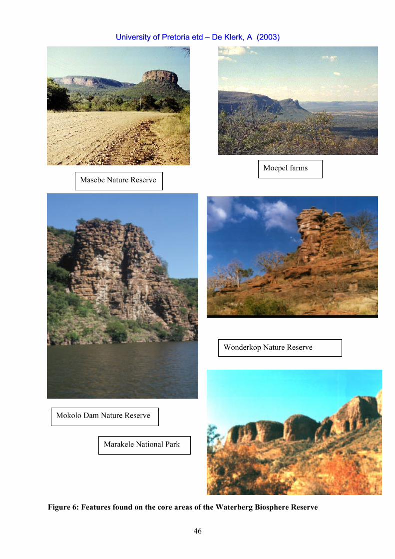
There are currently five core areas in the Waterberg Biosphere Reserve, of which only
one, Marakele, is proclaimed a National Park, Wonderkop and Mokolo Dam are
proclaimed provincial nature reserves, and Masebe is proclaimed a communal owned
nature reserve. Moepel is not proclaimed and is earmarked for a community owned
nature reserve with specific reference to ecotourism development. Map 6 indicates the
current zonation pattern of the Waterberg Biosphere Reserve with its distinct core areas.
UUnniivveerrssiittyy ooff PPrreettoorriiaa eettdd –– DDee KKlleerrkk,, AA ((22000033))
43
Core area 1: MARAKELE NATIONAL PARK
Marakele National Park is situated in the south-western corner of the Limpopo Province
and is bounded by longitudes 27E 30' and 27E 45' E and latitudes 24E 15' and 24E 30'S.
Marakele is one of seventeen National Parks in South Africa, currently covering an area
of ± 68 000 ha in the south-western part of the Limpopo Province. It has been managed
as a National Park since 1988, but was officially proclaimed a National Park on 11
February 1994 (South Africa, Department of Environmental Affairs and Tourism,
1994). Marakele consists of some of the most rugged mountain scenery in this country
and is situated mainly in the Waterberg Moist Mountain Bushveld in the savanna biome
which is synonymous to Acocks (1988) Sour Bushveld, which was listed by Edwards
(1983) as one of the 52 of South African veld types extremely lacking in conservation
(Van Staden, 2002). The Sour Bushveld covers 18 306 km, occurring in mountainous
areas in the Limpopo Province (Low and Rebelo, 1996). This park aims at conserving
components of pristine natural ecosystems, reintroducing rare and endangered species
that previously occurred in the area and making the park more accessible to tourists.
Bordering Marakele is the Welgevonden Private Game Reserve, currently consisting of
33 000ha. This Big Five reserve is zoned as part of the buffer zone.
Core area 2: MOKOLO DAM NATURE RESERVE
The Mokolo Dam is situated in the north-western part of the Waterberg Biosphere
Reserve, approximately 70 kilometers north-west of the town Vaalwater. The dam is
characterized by densely wooded mountains which mainly comprise of sandstone and
surrounding cliffs. This Nature Reserve plays an important role in providing outdoor
recreation, including both land and water orientated activities. Mokolo Dam was
proclaimed as a provincial nature reserve in 1993 and covers an area of 4 600 hectares
which includes the dam surface area of 914 hectares (Limpopo Province, Department of
Finance, Economic Affairs and Tourism, 1994). The current objectives for the Nature
Reserve are to conserve the biodiversity of the area and develop the area as a tourist
destination.
Core area 3: WONDERKOP NATURE RESERVE
UUnniivveerrssiittyy ooff PPrreettoorriiaa eettdd –– DDee KKlleerrkk,, AA ((22000033))
44
The Wonderkop Nature Reserve is situated in the north-western part of the Waterberg
District, about 130 km north of the town Mokopane. Low rainfall and high summer
temperatures are characteristics of the area. The vegetation can broadly be described as
Sweet Bushveld (Acocks, 1988) although certain areas of the Reserve are somewhat
sour, especially where sandy soils occur. The Reserve also adjoins the Glen Alpine
Dam, which forms 11 km of the eastern boundary of Wonderkop Nature Reserve which
was proclaimed as a provincial nature reserve in June 1994 with an area size of 16
100ha (Limpopo Province, Department of Environmental Affairs and Tourism, 1994).
The objectives of this reserve are to conserve the biodiversity of the area, specifically
the conservation of the Roan antelope and to promote the sustainable utilization of
natural resources from which the direct surrounding communities can benefit (Limpopo
Province, Department of Environmental Affairs and Tourism, 1994). This is the only
core area without a buffer zone contiguous to it but and therefore has a major challenge
of including the surrounding rural villages in its objectives and future developments.
Core area 4: MASEBE NATURE RESERVE
The Masebe Nature Reserve forms part of the north-eastern side of the Waterberg
escarpment. Geological formations comprise of sandstone and conglomerate into which
water erosion had carved the valleys and interesting forms as seen today. The veldtype
is Sour Bushveld (Acocks, 1988) on the high elevations and Sourish Mixed Bushveld
(Acocks, 1988) on the low-lying areas. Streams of water flow freely down the mountain
to form beautiful waterfalls in the rainy season. Due to the topography of the area, there
is a rich variety of habitat types that can accommodate a variety of game and bird
species. The inaccessiveness of the area kept it in a pristine state so that well- conserved
rock paintings and other archaeological sites still exist at Masebe Nature Reserve (refer
to point 3.2.2.). The land incorporated into Masebe Nature Reserve is communal land of
which government has always been the legitimate owners with the right to utilization.
These farms were previously utilized as grazing for the community’s cattle. In 1984,
negotiations with the affected communities and the traditional authority of Bakenberg
resulted in a tribal resolution which granted the authorities of the then Lebowa Nature
Conservation the right to develop and proclaim the area as a nature reserve. All affected
communities and authorities are satisfied with this land use option and the continued
UUnniivveerrssiittyy ooff PPrreettoorriiaa eettdd –– DDee KKlleerrkk,, AA ((22000033))
45
cooperation of the affected communities is dependent upon the economical, sustainable
and responsible utilization of the Reserve’s natural resource potential. The seven
villages that donated their land for the establishment of Masebe are structured into an
association that will be the legal authority responsible for the Reserve in partnership
with the relevant government authority. Masebe is 4 541,85 hectares in size and aims at
conserving its natural biodiversity and features with the emphasis on economic benefits
through tourism development to the communities involved. The reintroduction of game
species, especially White Rhinoceros, is currently under investigation.
Core area 5: THE MOEPEL FARMS
The Moepel farms are situated 75 km north-west of Mokopane and 20 km south- east
of Marken. The farms form part of the Waterberg mountain and extend onto the plains
below the escarpment while the area is mostly inaccessible for any kind of vehicles due
to its topography. The Moepel farms are currently state owned land put aside for
conservation purposes but have not yet formally protected. However, there now exists
an opportunity to proclaim this area as a communal nature reserve that is described as a
new type of protected area in the proposed Limpopo Province Environmental
Management Bill (Limpopo Province, Department of Finance, Economic Affairs and
Tourism, 2002). This may be regarded as an advantage as the local community can get
involved in its development from the initial stages. These farms could previously not be
developed into a nature reserve or park due to a lack of funds. Involved provincial
departments and local municipalities, however, have recently prioritized it to develop
the area as a “Big Five Reserve” owned by the surrounding communities (De Klerk,
2002). The Moepel farms are 28 330 hectares in size and adjacent to Masebe Nature
Reserve. To link these two reserves to be managed as a single unit has great potential.
Apart from conserving the rich biodiversity that occurs in this mountainous reserve the
main objective is water conservation which is of extreme importance due to the fact that
the rural villages in the plains below the escarpment have an extremely serious water
shortage due to drought and incorrect land use practices. Very remote and distinct
wilderness areas are zoned within these farms. Because little information is currently
available regarding all the biological components, it would be an ideal site for research
UUnniivveerrssiittyy ooff PPrreettoorriiaa eettdd –– DDee KKlleerrkk,, AA ((22000033))
46
and monitoring programmes that could be launched with the involvement of the
adjacent communities. Conversations with a number of local villagers revealed the
existence of undiscovered archeological sites in these mountains. As such, the Moepel
farms constitute a very important core conservation area within the Waterberg
Biosphere Reserve.
UUnniivveerrssiittyy ooff PPrreettoorriiaa eettdd –– DDee KKlleerrkk,, AA ((22000033))
46
Masebe Nature Reserve Moepel farms
Wonderkop Nature Reserve
Mokolo Dam Nature Reserve
Marakele National Park
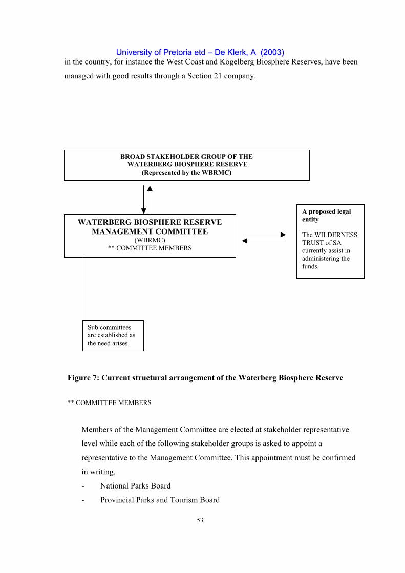
Figure 6: Features found on the core areas of the Waterberg Biosphere Reserve
UUnniivveerrssiittyy ooff PPrreettoorriiaa eettdd –– DDee KKlleerrkk,, AA ((22000033))
48
b) A buffer zone or zones.
The buffer zone has been clearly identified as areas adjacent to or nearby the core areas.
It is, therefore, not necessary for all the land surrounding the core areas to be zoned as a
buffer (UNESCO, 1996). The land use activities should rather be taken as criteria that
depict activities compatible with the conservation objectives of the core areas.
The buffer zone is owned by 28 private landowners whose land constitute the
Waterberg Nature Conservancy. This explains why the boundaries of the buffer zones
were drawn alongside private farm boundaries and not vague concentric rings. The
importance of zoning the properties of members of the Waterberg Nature Conservancy
as the buffer zone in the Waterberg Biosphere Reserve was that:
aa) It was easier to talk to a collective group of people about the biosphere reserve
concept than to start a process of negotiation with individual landowners. This
would have taken even longer than an already time consuming process.
bb) The Waterberg Nature Conservancy had already identified a common vision for the
area they live and work in. They are further bound by a constitution to ensure that
they fulfil certain objectives. Common ground was therefore found that greatly
assisted the initial stages of establishing the biosphere reserve.
cc) Criterium 7 of the Statutory Framework (UNESCO, 1996) refers to mechanisms
that need to be in place to manage human use and activities in the buffer zone or
zones. The Waterberg Nature Conservancy, representing the private landowners
involved, seemed to be an authority that could be responsible for managing the
buffer area.
dd) The landowners that are members of the Waterberg Nature Conservancy further
endorsed the biosphere reserve initiative and are committed to implement the
criteria set down by UNESCO’s MaB program.
The Waterberg Conservancy initiative started in 1982 (Walker, 1998). The Conservancy
currently has 30 members (of which 28 are private landowners) who control more than
146 157 hectares while the following large private game farms form an integral part of
the Conservancy: Lapalala Wilderness, Touchstone Game Ranch, Kwalata Wilderness,
UUnniivveerrssiittyy ooff PPrreettoorriiaa eettdd –– DDee KKlleerrkk,, AA ((22000033))