Chapter 2 THE SECURITIZATION OF WATER RESOURCE MANAGEMENT: A LITERATURE REVIEW 2.1 Introduction Barry Buzan, a leading scholar in broadening the meaning of security within the field of international relations, notes that the state has three component parts. These are the “idea” of the state, the “physical base” of the state and the “institutional expression” of the state (Buzan, 1991:65). Significantly, the physical base of the state is also the area in which states share the most similarities in relation to security (Buzan, 1991:91). The threats to the physical base of the state are common in all types of state, due to the similarity in the physical objects involved (Buzan, 1991:91), so such threats form the logical focus of either inter-state cooperation or conflict. Water is within the scope of Buzan’s thinking as it is an important natural resource on which stable economic development is based, forming a fundamental component of the “physical base” of the state, particularly under conditions of aridity. Ohlsson (1995a:4) contends that globally the point has been reached where water scarcity is increasingly being perceived as an imminent threat to development. Other commentators take this further by calling water scarcity the ultimate limit to development, prosperity, health and even national security (Falkenmark et al., 1990; Myers, 1989; Myers, 1993). While it is predicted that conflict surrounding water will intensify, so too will conflict resolution. Regime creation is a manifestation of this tendency. To this end Ohlsson (1995a:26) notes that there are five important aspects to consider with regard to the escalating water crisis. Firstly, it will be local in effect, but regional in its political and security-related implications. Secondly, it will affect those countries in arid and semi-arid areas with a high population growth rate. Thirdly, it will be a multifaceted crisis in the Third World, affecting human health, food insecurity, lost export incomes and the development of the industrial base of the economy. Fourthly, the transition from a situation of earlier relative water sufficiency to rising and conflicting demands on a now increasingly scarce resource will mean great social changes, placing enormous strain on the capability of states to manage the resultant internal conflicts. Finally, there will be no way to accurately predict the exact form that these conflicts will take in future. 31 University of Pretoria etd – Turton, A R (2003)
Transcript
Chapter 2
THE SECURITIZATION OF WATER RESOURCE MANAGEMENT: A LITERATURE REVIEW
2.1 Introduction Barry Buzan, a leading scholar in broadening the meaning of security within the field of international relations, notes that the state has three component parts. These are the “idea” of the state, the “physical base” of the state and the “institutional expression” of the state (Buzan, 1991:65). Significantly, the physical base of the state is also the area in which states share the most similarities in relation to security (Buzan, 1991:91). The threats to the physical base of the state are common in all types of state, due to the similarity in the physical objects involved (Buzan, 1991:91), so such threats form the logical focus of either inter-state cooperation or conflict. Water is within the scope of Buzan’s thinking as it is an important natural resource on which stable economic development is based, forming a fundamental component of the “physical base” of the state, particularly under conditions of aridity. Ohlsson (1995a:4) contends that globally the point has been reached where water scarcity is increasingly being perceived as an imminent threat to development. Other commentators take this further by calling water scarcity the ultimate limit to development, prosperity, health and even national security (Falkenmark et al., 1990; Myers, 1989; Myers, 1993). While it is predicted that conflict surrounding water will intensify, so too will conflict resolution. Regime creation is a manifestation of this tendency. To this end Ohlsson (1995a:26) notes that there are five important aspects to consider with regard to the escalating water crisis. Firstly, it will be local in effect, but regional in its political and security-related implications. Secondly, it will affect those countries in arid and semi-arid areas with a high population growth rate. Thirdly, it will be a multifaceted crisis in the Third World, affecting human health, food insecurity, lost export incomes and the development of the industrial base of the economy. Fourthly, the transition from a situation of earlier relative water sufficiency to rising and conflicting demands on a now increasingly scarce resource will mean great social changes, placing enormous strain on the capability of states to manage the resultant internal conflicts. Finally, there will be no way to accurately predict the exact form that these conflicts will take in future.
31
UUnniivveerrssiittyy ooff PPrreettoorriiaa eettdd –– TTuurrttoonn,, AA RR ((22000033))
This is a compelling argument to improve the basis of international relations, political science and hydropolitics theory. In fact most SADC member states comply largely with these aspects, specifically regarding two critical components - aridity is the norm for many states, and almost everywhere there is a rapidly growing population base. Specifically however, South Africa is approaching the point where water deficit is the dominant condition, with basin closure being a stark reality. This is also happening in three riparian states that share various international river basins with South Africa - Botswana, Namibia and Zimbabwe - all of which also happen to be the most economically developed states in the SADC region. The significance of this in strategic terms becomes apparent when contextualized within the recent global study, which indicated that of the seventeen international river basins that are considered to be “at risk”, one third of the global total occur in the SADC region (Incomati, Kunene, Limpopo, Okavango, Orange & Zambezi), with the 4 most economically developed states in that region (South Africa, Botswana, Namibia and Zimbabwe) being riparian to all of these rivers in one form or another (Wolf et al., 2003:47). In the hydropolitical context of South Africa, two important issues converge within the scope of this study. Firstly, the country is reaching the limits of its readily available supply, with all surface water projected to be have been mobilized within the next decade (Ashton, 2000a; Ashton & Haasbroek, 2002:190). Secondly, approximately two thirds of the South African surface area falls within international river basins (Gleick, 1989: 337). There is thus a situation in South Africa where water resource managers are being confronted with increasing levels of water deficit, and the majority of the surface water that is available is found in international river basins, being shared with countries that are also facing similar water scarcity problems. Some of these river basins are facing closure, so competition for water is becoming high, particularly during times of drought. The key question that needs to be answered is what are the consequences of basin closure? Flowing from that, the next question that needs to be answered is to what extent does the securitization of water resource management arise from these consequences? These two questions consequently form the focal point of this chapter. Significantly, South Africa has been involved with the creation of a number of regimes within various international river basins as will subsequently be discussed. There is thus a wealth of information available from within South Africa with which to develop a deeper understanding of the process of the securitization of water resource management, and the
32
UUnniivveerrssiittyy ooff PPrreettoorriiaa eettdd –– TTuurrttoonn,, AA RR ((22000033))
role of regime creation as a potential element of desecuritization, as an alternative approach to the water war school of thought. 2.2 The Consequences of Basin Closure: The Jordan River as a Classic Case
“The Middle East as a region ran out of water in the 1970s” (Allan, 2000:5). The hydropolitical literature is littered with ill-conceived terminology that is based on the notion of a region “running out of water”. What is needed for the purposes of this study is to gain greater conceptual clarity on what “running out of water” means in factual terms, because this is the starting point of the train of logic that has been used to order this study. The first aspect that needs to be clarified is what is actually meant when commentators refer to a country or region as “running out of water”? Once this has been established, the second element of the core argument that needs to be established is to what extent “running out of water” is linked to the growth in perceptions of insecurity in different riparian states? The best example of this is the Jordan River basin, which is significant because it is a closed river basin, and it lies at the heart of the region’s strategic security sub-system - the Palestine/Israel conflict and peace process (Buzan et al., 1998 cited by Allan, 2000:60-61). This gives an insight into the hydropolitical dynamics of securitization that will be applied to the South African case study. 2.2.1 Basin Closure as a Concept The concept of basin closure was first coined by Seckler (1996) when he used the term to characterize river basins with no utilizable outflow. In other words, basin closure implies that the abstraction, transfer and use of water upstream within a given river basin renders that water unavailable for further use downstream. One of the results of basin closure is that water has to be mobilized from elsewhere. This usually takes the form of IBTs, where water is taken from a donor basin and transferred to a recipient basin in an attempt to balance out the prevailing water scarcity in the recipient basin. An undesirable and unavoidable element of this mobilization of water is the possibility of resource capture, which is evident in many of the large river basins globally. This is consistent with what Johan Galtung refers to as “structural violence”, or the existence of “exploitative relations between groups in general and societies in particular”, which are one of the causes of insecurity in international relations (Galtung, 1980:64 in Doughman, 2002:193).
33
UUnniivveerrssiittyy ooff PPrreettoorriiaa eettdd –– TTuurrttoonn,, AA RR ((22000033))
2.2.2 Jordan River Basin: Classic Case of Water Scarcity and Political Insecurity
“The Jordan River [b]asin, including the upper Jordan and the Yarmouk, provides 60 per cent of Israel’s water and 75 per cent of Jordan’s. At the same time, only 3 per cent of the Jordan basin area ... is situated within the borders of the pre-1967 Israel (Anderson, 1988:7). The Jordan basin ... is the smallest river in the Middle Eastern region, and runs through hotly debated territories”(Lindholm, 1995:58).
Ever since the early days of Zionism, water scarcity has been of great concern to Zionist planners, and later to the Israeli government. As early as 1916, the World Zionist Organization spoke of having the Jordan River system included in Palestine, with the Litani River delimiting the northern border (Nijim, 1990:317; Lindholm, 1995:60). As the First World War drew to an end, Emir Faisal, the son of Hussein the Sharif of Mecca, moved to Damascus in anticipation of ruling Syria. From here he wrote a letter to Chaim Weizmann, a key Zionist negotiator, trying to get a common agreement before the Paris Peace Conference at which the territory of the Ottoman Empire was to be redistributed (Trottier, 1999:40). This was not to be however, because in terms of the Sykes-Picot Agreement that was concluded between France and Great Britain during the First World War, it was envisaged that the French would take control over the Litani River and Upper Jordan Basin; Lake Tiberias would fall into both an international and French zone; both the French and British would take control of the Yarmouk Valley; the present day West Bank would become an international zone; and the British would take control over present day Jordan (then known as Transjordan) (Trottier, 1999:40). At the Paris Peace Conference in 1919, Chaim Weizmann stated that the boundaries of Palestine were to include the headwaters of the Jordan River, the lower Litani in what is now modern day Lebanon, and the lower Yarmouk in what is now modern day Jordan. It was also considered important by Weizmann to control the very sources of water flows, thus emphasizing Mount Hermon and the drainage of the Jordan River (Weisgal, 1977 as cited by Lindholm, 1995:60). Weizmann subsequently wrote a letter to British Prime Minister Lloyd George stating that the whole economic future of Palestine depended on water for irrigation and electric power, and this water must come largely from the foothills of the Jordan and the waters of the Litani (Jaber, 1989:67). In essence, the British agreed with the Zionists on the delimitation of the state of Israel at that time (Lindholm, 1995:61). The final agreement emerging from the Paris Peace Conference was signed in London on 4 December 1920, but the French delegation had managed to
34
UUnniivveerrssiittyy ooff PPrreettoorriiaa eettdd –– TTuurrttoonn,, AA RR ((22000033))
counter the British proposal on the delimitation of the state of Israel that would have included access to water from the Jordan and Litani rivers, promising instead that Jewish settlements could use water freely from the Upper Jordan and Yarmouk Rivers, but that they would remain under French control along with the Litani River (Trottier, 1999:42). Sovereignty over the resource was thus left firmly in French control, but on the understanding that the Jewish settlers could have access to the water. Map 1. The Jordan River Basin.
Source: Lindholm 1995:56. France and Britain signed a bilateral treaty on 23 December 1920 - what became known as the Franco-British Agreement - becoming a key treaty in the determination of water use in the Jordan River basin (Trottier, 1999:42). The same treaty determined the control regimes of the Yarmouk, Tigris, Euphrates and Jordan Rivers in keeping with the
35
UUnniivveerrssiittyy ooff PPrreettoorriiaa eettdd –– TTuurrttoonn,, AA RR ((22000033))
territorial division that had just taken place. There were to be two principles involved. Article 8 stipulated that the needs of the French mandated1 territories would receive “prior satisfaction”. Furthermore, the French government would give “the most liberal instructions concerning the use of the surplus of these waters for the advantage of Palestine” (Trottier, 1999:42-43). The Franco-British Agreement located the Banyas River (one of the main tributaries of the Jordan) inside the mandated2 territory of Palestine. Jews started to acquire land in some of the most fertile parts of the British mandated territory of Palestine between 1920 and 1939. This became the genesis of the creation of a social class of landless Arab peasants, which is a significant factor in the hydropolitical equation to this day (Trottier, 1999:44). In 1922 Britain officially declared that its policy concerning Jewish immigration towards the Palestine Mandate would be governed by what it called the “absorptive capacity” of the region. This resulted in emphasis being placed on the agricultural sector, which became one of the elements of subsequent Zionist ideology (Trottier, 1999:43). This emerging ideology saw water becoming a key factor in determining the absorptive capacity of a future Jewish state, thereby contributing to the birth of the subsequent Israeli hydraulic mission. The border with the French mandated territory of Syria was demarcated in 1923 under the Anglo-French Agreement. This left the Banyas River 1-km inside Syria, thereby becoming the genesis of future conflict3 because the two main tributaries of the Jordan River were now located outside the future state of Israel (Trottier, 1999:43). Violent social clashes between Arabs and Jews occurred in the Palestine Mandate during 1929. The Shaw Commission was set up to investigate the incident and identified the source of violence as being the growing fear by Arabs of Jewish immigration and land acquisition (Trottier, 1999:44). A report by the Irrigation Committee that was also published in 1929 noted a dangerous drop in the hydrostatic level around Haifa and Tel Aviv, stating that salinization was taking place, thereby introducing groundwater into the overall hydropolitical equation (Trottier, 1999:45). The report also deplored the undefined nature of water rights in Palestine.
1 Under the League of Nations, mandates were given to France to administer Syria and Lebanon. 2 Under the League of Nations, mandates were given to Britain to administer Transjordan and Palestine. 3 These borders become the basis for the subsequent 1947 UN decision to create the state of Israel (Shuval, 2000:45-6).
36
UUnniivveerrssiittyy ooff PPrreettoorriiaa eettdd –– TTuurrttoonn,, AA RR ((22000033))
Hope-Simpson, a technocrat commissioned by the British government, was sent to investigate the immigration aspects of the Palestine Mandate in 1930. He wrote a report saying that intensive agriculture should be promoted along with the use of irrigation, as this would allow the Mandate to fulfil its obligations to both Jews and Arabs (Trottier, 1999:44). The Jewish Agency responded positively to this report because irrigation would increase the absorptive capacity of the future Jewish state. The Jewish Agency offered to set up an irrigation and colonization company in Palestine in return for part of the land. The Arab Revolt broke out in 1936, subsequently disrupting the settlement of water rights (Trottier, 1999:47).
Harris, an irrigation consultant in Palestine, succeeded in acquiring an ordinance that submitted the drilling of a well to the prior granting of a permit in zones called “public water supply areas”, by means of which the government was given the right to drill boreholes in order to carry out hydrographic studies (Trottier, 1999:47). A series of boreholes were drilled in the Jordan Valley in order to instruct the department responsible for the Partition Plan. The unrest from the 1936 Arab Revolt still hindered the settlement of water rights however, and the subsequent Second World War and Israel War of Independence meant that the issue could not be settled satisfactorily at that time. The United Nations (UN) General Assembly adopted Resolution 181 on the Partition of Palestine during November 1947, with the official borders as defined in the 1923 Syrian4 and Palestine Mandates becoming the basis on which the border demarcation took place (Shuval, 2000:45). This gave Israel control of the 10-m wide strip along the eastern fringe of Lake Tiberias, and the Hamat Gader (El Hama) Springs area contiguous to the Yarmouk River (Shuval, 2000:45). This led to the eventual displacement of 700,000 Palestinians, leaving only 150,000 Arabs inside the state of Israel at the end of the War of Independence (Trottier, 1999:53). Chaim Weizmann became the first President of Israel in 1948 (Lindholm, 1995:60), bringing with him strongly held views about the linkage between access to water and state security. Almost immediately, extensive water subsidies were introduced to protect the newly established kibbutzim (Lindholm, 1995:63). This implied that there was no incentive to save water, so water use by the Jewish settlers started to take off under the Israeli hydraulic mission, which sought to make the desert bloom as part of a Zionist vision of self-sufficiency and increased absorptive capacity. This trend can be seen in Figure 2. 4 Syria became independent in 1946.
37
UUnniivveerrssiittyy ooff PPrreettoorriiaa eettdd –– TTuurrttoonn,, AA RR ((22000033))
During 1946, a water engineer from the Tennessee Valley Authority (TVA) in the United States of America (USA) by the name of Hays, began working on a strategic water plan, at the invitation of the Zionist Organization of America (Trottier, 1999:53). The Hays Plan was published in 1948 as part of the establishment5 of the state of Israel. This proposed a canal between the Mediterranean Sea and the Dead Sea - referred to as the Med-Dead Canal - and a diversion of water to the Negev Desert (Trottier, 1999:53) (see Map 2). Map 2. Various Water Diversions in Israel.
Source: Wolf 1998. 5 The state of Israel was established by proclamation on 14 May 1948 when the British Mandate in Palestine came to an end.
38
UUnniivveerrssiittyy ooff PPrreettoorriiaa eettdd –– TTuurrttoonn,, AA RR ((22000033))
The Arab riparian states were immediately opposed to this diversion into the Negev Desert, as it meant less water in the lower Jordan Basin. On the day after the establishment of the state of Israel, Egypt, Iraq, Jordan, Lebanon and Syria invaded it. The newly independent state of Israel thus went to war between 1948-9 in what became known as the War of Independence, with the outbreak coinciding roughly with the publication of the Hays Plan. There was no direct linkage between these two events however. Arab forces cut off the water supply to West Jerusalem during the war as part of a well-established doctrine in which water was used as a weapon (Gleick, 1998:128). The borders of the new state of Israel were thus changed within days of independence, and were determined by the 1949 Armistice Agreement (Trottier, 1999:49). The so-called “green line” between Israel and Jordan had been negotiated before the armed struggle and gave important aquifers to Jordan. It also gave most of the Jordan River downstream of Lake Tiberias to Jordan, which now occupied both banks (Trottier, 1999:50). The 1949 Armistice Agreement included a 10-m wide strip of land along the eastern fringe of Lake Tiberias as being under Israeli control, along with the Hamat Gader (El Hamat) Spring’s area contiguous to the Yarmouk River. The Syrian Army was unhappy with this fact, so they occupied these areas by force after the Armistice Agreement had been signed, in direct contravention of that agreement6. Israel occupied a small territory around Al-Baqura and Naharayim, thereby allowing control over the Jordan and Yarmouk River to be exercised (Trottier, 1999:51). The 1949 Armistice Agreement between Syria and Israel stipulated that a strip of land 100 metres east of the Jordan River between Lake Tiberias and Huhleh Lake was to be transformed into a demilitarized zone controlled by Syria. The same was to apply to a 10-m wide strip of land along the East shore of Lake Tiberias, which had previously belonged to the Palestine Mandate according to the 1923 Anglo-French Agreement (Trottier, 1999:51). The subsequent Israeli/Jordanian Peace Accord in October 1994 indicated that the sole motivation for this occupation was control over water resources during the 1948-9 war. During this time, Israel also gained control over two large aquifers - the coastal aquifer that stretches from Mount Carmel to Gaza, (see Map 1) with a maximum yield of 280 x 106m3yr-1; and the Yarkon-Taninim aquifer that stretches from Mount Carmel to Beersheva, which is fed by water that comes from west of the green line (Trottier, 1999:51-52). 6 As a result these lines were never clearly established, leading to different interpretations in the Shepherd’s Town negotiations that were subsequently held in February 2000 (Shuval, 2000:45).
39
UUnniivveerrssiittyy ooff PPrreettoorriiaa eettdd –– TTuurrttoonn,, AA RR ((22000033))
2.2.3 The Israeli Hydraulic Mission In pre-1967 Israel, the National Water Carrier Project became the most ambitious development project ever undertaken, becoming a fundamental component of the Israeli hydraulic mission. The significance of this is evident in Figure 2 as a rapid growth in water consumption from 1947 to 1967. Part of that hydraulic mission was the centralized control over water resources, under the management of Mekorot, the state water company, administered by the Israeli Water Commission. This was under the authority of the Ministry of Agriculture, giving the agricultural sector priority of use. Water was mobilized in order to develop agricultural settlements in various parts of the country, partly to create employment opportunities for Jewish settlers; partly to fulfil the earlier Zionist ideological ideal; and partly for national security reasons. The dominance of the agricultural sectoral water use is shown in Figure 2. The water, economic development and national security nexus thus started to emerge as a dominant feature of the hydropolitical dynamics of the Jordan River basin between 1947 and 1967. Figure 2. Israeli Water Consumption from 1947-1993.
Droughts
Domestic
Industrial
Approximated by 1957
Approximated by 1967
Agriculture
Water Carrier Period– additional 0.4 bcm / yr
Additional 1 bcm / yr usage
Approximated by 1947
1992 1982 1977 1972 1962 1957 1952 1947
2
1.5
1
.5
bcm
/ yr
1967 1987
Source: Allan 1996c:85; Allan 2000:249.
Hydraulic Mission Era
Immediately after the 1948-9 War of Independence, construction was started on the Israeli National Water Carrier Project (Lindholm, 1995:67). This project was designed to
40
UUnniivveerrssiittyy ooff PPrreettoorriiaa eettdd –– TTuurrttoonn,, AA RR ((22000033))
take a 2.7-m diameter pipeline for a distance of 300-km from the Jordan River to the Negev Desert. It drew water from the Upper Jordan and the main storage reservoir (Sea of Galilee) and distributed it over the entire country all the way into the Negev Desert in order to sustain new settlements (Lindholm, 1995:64). The extent of the project can be seen on Maps 1 & 2. The Syrians objected to the abstraction point at Gesher B’not Ya’akov on the Jordan River, which was then in the Demilitarized Zone that had been established in the 1949 Armistice Agreement between Syria and Israel. Syrian tanks fired at Israeli construction workers and equipment (Shuval, 2000:42), becoming one of the often-cited examples of water as a cause of war (Gleick, 1998:128; Wolf, 1995; Wolf, 1997; Samson & Charrier, 1997). A military coup d’état took place in Syria during 1949 making Husni Zaïm the new leader. Zaïm offered Israel half of Lake Tiberias and he also undertook to permanently resettle 300,000 Palestinian refugees in an attempt to make the offer attractive (Trottier, 1999:50). It was rejected however, and a subsequent hearing by the Foreign Affairs and Security Committee of the Knesset revealed that the reason for this was the desire by Israel to control the one shore of Lake Tiberias, the East Bank of the Jordan River and the Mey Marom (Trottier, 1999:50). The Syrian Army was evacuated from the parts of Palestine that were demarcated in the 1947 Partition, and which had been occupied by Israel as the result of the 1948-9 War of Independence (Lindholm, 1995:67). Syria claimed that Israel may not foster any changes to the occupied area, but Israel insisted on her right to develop the agricultural potential of the occupied area, in keeping with the prevailing hydraulic mission. The United States (US) State Department identified the issue of Palestinian refugees as a major obstacle to future peace. On the strength of this assessment, the State Department pressurized Israel to accept a separate peace with Syria in terms of the Zaïm proposal (Trottier, 1999:57). Israel steadfastly refused to accept the offer despite the attraction of the Palestinian refugee issue because access to water was seen to be more strategically relevant at the time. During the ensuing period of uneasy peace, Syria claimed that all of the water in the Jordan River is derived from rainfall in Syria and Lebanon. As such, according to this logic, the Jordan River consists of “Arab Water” that belongs to the two upstream countries (Shuval, 2000:48). Under this rationalization, the maximum Syrian claim might include the entire flow of the Banyas River at 120 x 106m3yr-1 and the flow of 30 x 106m3yr-1 from the Golan Heights, as well as the entire flow of the Hasbani River of 150 x 106m3yr-1 for Lebanese use. This totals some 300 x 106m3yr-1. Israel countered this
41
UUnniivveerrssiittyy ooff PPrreettoorriiaa eettdd –– TTuurrttoonn,, AA RR ((22000033))
claim by stating that for the past fifty years neither Syria nor Lebanon actually used this water, so it belongs to Israel by virtue of the principle7 of prior use (Shuval, 2000:48). During the same period of time, Israel established the first settlements in the demilitarized zone to the north (Lindholm, 1995:67). The Absentee Property Law was promulgated in Israel during 1950 (Lindholm, 1995:81). This stated that all Palestinian Arab displaced persons and refugees from the 1948 War of Independence were declared absentees, which implied that they were denied all rights to subsequent Israeli citizenship, rights to their former lands and rights to other property that they may have previously owned in Israel (Davis, 1987:17). This gave impetus to the phenomenon of the landless, and now stateless, Palestinian Arab, which has persisted into present times. During 1951 Jordan made its plan to irrigate the Jordan Valley public. This plan had as a central component, the diversion of the Yarmouk River. Israel responded by commencing with the drainage of the Huhleh swamps that were located in the demilitarized zone between Israel and Syria. Yigal Allon, a commentator on Israeli strategic affairs, advocated that any “Syrian attempt to thwart Israeli development projects in the Huhleh area and/or concerning the utilization of the water of the Jordan River” should be considered as a reason to go to war (Yaniv, 1987:82). A series of border skirmishes ensued between Israel and Syria as a result of this. Syria responded by occupying the Al-Hamma strip, giving them control over the Yarmouk River (Trottier, 1999:52). After the exchange of sporadic gunfire between Israel and Syria, Israel finally moved its water intake to the Sea of Galilee (Wolf, 1998:256; Gleick, 1998:128). Some commentators call this a water war (Gleick, 1998:129; Starr, 1991; Wolf, 1995; Wolf, 1997). This period of tensions ultimately led to Israel abandoning the first attempt to deviate water from Lake Tiberias at the site of Jacob’s Daughters’ Bridge, but Israel finally drained the Huhleh swamps and resettled them with people (Lindholm, 1995:67; Samson & Charrier, 1997; Trottier, 1999:52; Wolf, 1997). During 1953 Israeli plans to divert Jordan River water from north of the Sea of Galilee in the demilitarized zone on the Syrian border were again initiated, this time at a position that was less favorable in technical terms, but that was safer from Syrian artillery fire (Trottier, 1999:52). Israel also announced plans for an irrigation canal through the demilitarized zone that would separate Syria from the demilitarized zone (Lindholm, 7 This provides a classic example of the use of legal interpretations to justify hegemonic control over water resources in contested international river basins.
42
UUnniivveerrssiittyy ooff PPrreettoorriiaa eettdd –– TTuurrttoonn,, AA RR ((22000033))
1995:67-8). The ensuing dissention between Israel, Syria and Jordan resulted in American President Dwight Eisenhower calling for a cease-fire and appointing Eric Johnston as his personal envoy and roving ambassador with the mandate to find a comprehensive programme to develop the Jordan River on a regional basis (Shuval, 2000:43). This was based on the TVA model in America and aimed at the equitable distribution of water from the Jordan and Yarmouk Rivers. The Johnston United Water Plan was significant because it was the first attempt at developing a basin-wide plan for the entire Jordan River. Israel, Jordan and Lebanon initially approved of the Johnston United Water Plan, but Syria did not. This in turn hindered Jordan and Lebanon from endorsing it. The Arab League also came out in opposition to the Johnston United Water Plan, so it was never implemented, but it became the foundation on which subsequent water sharing principles were to be developed. The Israeli National Water Carrier Project was cited as one of the main reasons for Syrian hostilities towards the Johnston United Water Plan (Lindholm, 1995:68; Wolf, 1998:128). As part of this exchange of hostilities with Israel, Syria first mooted the idea of developing the Maqarein Dam on the Yarmouk River (Lindholm, 1995:71) (see Maps 1 & 2). Jordan and Syria agreed to share the water, but Israel lodged a protest. Because of this, Jordan was forced to reach an agreement with Israel in order to implement the project (Lindholm, 1995:72). On 11 October 1955, the Technical Committee of the Arab League announced their support of the Johnston United Water Plan, but it again failed to gain the necessary approval because of fears that “their agreement would imply indirect recognition… [of Israel]” (Shuval, 2000:44). The Johnston United Water Plan thus broke down, leaving both Syria and Lebanon with almost total control over the major sources of supply to the Jordan River basin, which gave rise to intense feelings of insecurity in Israel. This insecurity was based on a threat perception that had been formed in a broader political setting and subsequently became part of the Israeli security doctrine. This feeling of insecurity prevailed until the 1967 Six-Day War when the borders were radically altered, and with that, control over the source of water was again established by Israel (Gleick, 1993a:85; Wolf, 1995; Wolf, 1997; Samson & Charrier, 1997). There were only limited initiatives to utilize these resources at the time however. In terms of the Johnston United Water Plan, the water allocations presented in Table 1 were envisaged. It is noted by Shuval (2000:43) that the allocations to Syria and Lebanon were exactly the amounts requested by the Technical Committee of the Arab League,
43
UUnniivveerrssiittyy ooff PPrreettoorriiaa eettdd –– TTuurrttoonn,, AA RR ((22000033))
which under Egyptian leadership had formulated the so-called “Arab Plan” for allocation of water from the Jordan River basin. Table 1. Volume of the Jordan River that was Apportioned in the Johnston United
. Water PlanRiparian State Allocation Comments Jordan 480 x 106m3yr-1 Syria 132 x 106m3yr-1 42 x 106m3yr-1 from the Banyas and Jordan Lebanon 35 x 106m3yr-1 Israel 466 x 106m3yr-1 Total Annual Flow 1113 x 106m3yr-1
Source: Stevens 1965 as cited by Shuval 2000:43. After the breakdown of the Johnston United Water Plan, an informal agreement between Jordan and Israel became the foundation for the future funding of both the National Water Carrier Project in Israel and the East Ghor Canal in Jordan (Shuval, 2000:44) (see Maps 1 & 2 for details of their location). It was on the basis of this agreement that Israel understood that Jordan would eventually construct the West Ghor Canal as well, in order to supply the Palestinians on the West Bank with 150-200 x 106m3yr-1 (Shuval, 2000:44). The West Ghor construction never took place however, and the East Ghor Canal was destroyed in two Israeli military raids before it could become operational (Gleick, 1998:129; Samson & Charrier, 1997). Jordan started construction of the East Ghor Canal in 1958 with funding from the USA. The reason for American involvement was to permanently settle the Palestinian refugees from the War of Independence (Trottier, 1999:57). The actual purpose of the canal was to provide water to Amman however, and to support irrigation activities within Jordan. In order to guarantee continuous flow, two dams had been proposed on the Yarmouk River (Haftendorn, 2000:61). This took water from the Yarmouk River 69-km along the Jordan Valley, but Israel viewed this as a potential threat because the Yarmouk is the most important tributary of the Jordan River (Trottier, 1999:56) (see Map 2). Only the East Ghor Canal was completed by the time the 1967 Six-Day War broke out, and Israeli forces destroyed this during the opening hours of the armed conflict (Gleick, 1998:129). Syria managed to get the water issue onto the agenda of the Arab League Summit during 1959 again. As a build-up to this, Israel told the USA that the Johnston United Water Plan should be continued. In the meantime, Jordan applied to the World Bank for an
44
UUnniivveerrssiittyy ooff PPrreettoorriiaa eettdd –– TTuurrttoonn,, AA RR ((22000033))
irrigation project with the Maqarein Dam on the Yarmouk River as a component. Israel objected, claiming that this would undermine the Johnston United Water Plan. Syrian fears were escalated by the perception that she was being left out of the emerging water arrangements. It was this fear that formed the basis of the renewed request for Arab League support (Lindholm, 1995:68). The 1959 Arab League Summit decided to endorse the proposed diversion of the Jordan River in order to counter the strategic value of the Israeli National Water Carrier Project. Details of this proposed diversion are shown on Map 2. This is an example of the use of water as a weapon of war, which is possible in closed river basins simply because few other alternatives exist. The whole scheme was intended to divert the Hasbani, the Dan and the Banyas to the Yarmouk River and was consequently seen by Israel as being a direct threat to its national security in keeping with the prevailing threat perceptions (Lindholm, 1995:69). The final decision to actually implement these plans was only taken in 1961 however. Even then it was only in 1964 that Syria actually gave the go ahead. One commentator (Yaniv, 1987:105) interprets this as the reluctance by Nasser, who was the head of the Arab League at the time, to actually implement the project, for fear of escalating existing tensions. Israel drafted Law No. 57198 on 3 August 1959 (Trottier, 1999:53). This unified the water laws in the occupied area under Israeli control, enshrining some of the principles that were originally advocated by the British through the activities of Harris (Trottier, 1999:46), thereby countering the laissez faire attitude of the Ottoman Empire that left each village with its own set of customary water laws. This new Israeli law withdrew water from the domain of private ownership in response to Jewish agricultural development (Trottier, 1999:54). The phenomenon of the landless Arab was thus given an additional boost at this time (Trottier, 1999:47). Between 1959 and 1965 agricultural production in the Jordan valley doubled (Lindholm, 1995:72). It was for this reason that the East Ghor Canal and Maqarein Dam were needed according to Syria. Israel perceived the proposed Arab League diversion as a potential threat, which could divert as much as 300 x 106m3yr-1 away from Israel. Consequently Israel objected to the UN that these proposed diversions were a violation of international law, infringing on her sovereign rights as a downstream riparian (Shuval, 2000:44-5). All role-players did not share this threat perception however, and as the National Water Carrier was nearing completion in Israel, Arab fears of an impending loss of water also started to increase. This provides empirical evidence of increasing perceptions of 8 This became known as the 1959 Water Law (Trottier, 1999:53-55).
45
UUnniivveerrssiittyy ooff PPrreettoorriiaa eettdd –– TTuurrttoonn,, AA RR ((22000033))
insecurity as the result of basin closure when in the presence of a strongly articulated threat perception that views water as an instrument of power and potential political control. Syria called for a military struggle with Israel at the Cairo Summit during December. Nasser intervened and the motion was not accepted (Trottier, 1999:58). Shimon Peres, in his capacity as Deputy Defence Minister, announced in 1962 that one of the issues that could bring about another Arab-Israeli war was “if Israel seizes waters that are not its own - according to its neighbor’s” (Yaniv, 1987:86; Lindholm, 1995:69). At the same time, the Israeli Prime Minister Levy Eshkol said that water could be regarded as a casus belli because “the water is like the blood in our veins”, providing an example of the ideological dimension of water, closely linking it to the issue of national security yet again (Lindholm, 1995:69). This shows how the Israeli hydraulic mission was based on a deeply felt political ideology, which held water as an essential element for survival and consequently a legitimate target during times of hostility. 2.2.4 Water as a Potential Casus Belli in the Jordan River Basin Despite repeated statements by Israeli spokesmen that water was a casus belli, and that Israel would restrict her policy to one of “flexible response”, the Syrians continued to escalate their military activities. Israel thus resorted to “massive retaliation” (Yaniv, 1987:106) and bombed the Syrian diversion installations for the East Ghor Canal two months prior to the outbreak of the 1967 Six-Day War. Israel decided to take these military steps to stop construction of the East Ghor Canal when the Arab League attempted to divert the Banyas and Hasbani, two important tributaries of the Jordan River, which in terms of the prevailing threat perception, was seen to result in potential Israeli insecurity (Gleick, 1998:129; Haftendorn, 2000:60-1; Shuval, 2000:44-5; Wolf, 1998:256). Construction of the Syrian diversion stopped in July 1966 (Wolf, 1998:256; Gleick, 1998:129). A gradual escalation of troop deployments occurred, and a number of skirmishes took place. Syria, using belligerent rhetoric, threatened large-scale war and could not subsequently back down without losing face, even when Arab League support was reduced. Syria also started to use the Palestinian guerilla movement Al Fatah to carry out clandestine attacks against the Israeli National Water Carrier Project. Water infrastructure thus increasingly became a target of war in keeping with the prevailing political ideology that was already based on the belief that water provided sustenance and should thus be denied to the enemy (Lindholm, 1995:69). The die was consequently cast
46
UUnniivveerrssiittyy ooff PPrreettoorriiaa eettdd –– TTuurrttoonn,, AA RR ((22000033))
for the next period of war, with the respective riparian states seemingly locked into an inevitable political showdown, with access to water as a central strategic element. Israel subsequently occupied the West Bank and Gaza in the 1967 Six-Day War, which gave access to, and control over, a number of strategically important aquifers9 (Lindholm, 1995:55). The location and relevance of these can be seen on both Maps 1 & 2. The control over West Bank water was managed by military rule10 from that time on until 1982 (Lindholm, 1995:78). Palestinian water scarcity on the West Bank consequently became a fact of daily life, and Palestinian agriculture became dependent on the water allocation system that was established by the military occupation in the Six-Day War (Lindholm, 1995:82). This is further evidence of systematic policies of resource capture that were all designed to increase Israeli hegemony in the basin. Only one of the dams on the Yarmouk River had been completed by 1967, but it was totally destroyed by Israeli forces in the Six-Day War, which altered the entire hydropolitical balance of power with the subsequent occupation of the Golan Heights and the establishment of a Security Zone in South Lebanon (Haftendorn, 2000:61). The occupation of the West Bank meant that Israel now had unlimited access to the key underground aquifers located there - thereby consolidating its hydrostrategic territory (Wolf, 1996; Haftendorn, 2000:61). Israel also gained control of the Banyas River during the Six-Day War (Trottier, 1999:61). Israel issued Military Order No. 158 after the Six-Day War, imposing control over the future development of groundwater (Rowley, 1990:39; Lindholm, 1995:80; Trottier, 1999:60). This law established that no person was allowed to own or administer a water institution without an official permit; it was permissible to deny an applicant a permit, revoke or amend a license, without giving any explanation; the appropriate authorities may search and confiscate any water resource infrastructure for which no permit existed, even if the owner had not been convicted. In addition to this, no Palestinian well was allowed to exceed a depth of 140-m, while Jewish wells were allowed to go below 800-m in depth, further entrenching insecurity of supply for the Palestinian people (Lindholm, 1995:80). Yet again this provides empirical evidence of a systematic policy of resource
9 This is what Wolf (1996) refers to as “hydrostrategic territory”. 10 Law No. 5719 unified all water law in the occupied territories where it had been a previously fragmented system based on local customary rights, differing from village to village. Other military laws followed, for example Law No. 5716 on water metering, and Law No. 5718 on drainage and flood control (see Trottier, 1999:52-55).
47
UUnniivveerrssiittyy ooff PPrreettoorriiaa eettdd –– TTuurrttoonn,, AA RR ((22000033))
capture and induced scarcity in order to ensure political and economic hegemony by Israel. The outcome of the Six-Day War was that Israel had established access to fresh water resources from the Golan Heights, control of the Sea of Galilee, and control over the groundwater aquifers along the West Bank - what Wolf (1996) calls “hydrostrategic territory” (see Maps 1 & 2). Groundwater is a strategically important resource, with the Mountain Aquifer Complex containing three separate aquifers of note (Lindholm, 1995:77). These are the West Bank and the Northern Aquifer that flows towards the Jordan River; the Eastern Aquifer that flows towards the Jordan River; and the Western Aquifer that flows towards the Mediterranean Sea - called the Yarqon-Taninim Aquifer in Israel, which was shared by both Palestinian and Jew before the 1967 Six-Day War. It becomes instructive to ask the question to what extent the Six-Day War was motivated by the Israeli desire to gain access to, and control over, water resources? Some insight is offered from a speech that was made by David Ben-Gurion in 1973 in which he said that:
“It is necessary that the water sources, upon which the future of the Land depends, should not be outside the borders of the future Jewish homeland. … For this reason we have always demanded that the Land of Israel include the southern banks of the Litani River, the headwaters of the Jordan, and the Hauran Region from the El Aujua spring south of Damascus. All the rivers run from east to west or from north to south. This explains the importance of the Upper Galilee and the Hauran for the entire country. The most important rivers of the Land of Israel are the Jordan and the Yarmouk. The Land needs this water. Moreover [it needs] the development of industry on water power for the generation of electricity” (cited by Cohen, 1986:122 in Lindholm, 1995:61).
In the same vein Yehuda Litani, a correspondent for the newspaper Ha’aretz, indicated that the “incorrect application” of drilling in the West Bank, outside Israeli control, could lead to salinization of the water resources. Litani stated that “it is possible that this is the true reason, so far unknown, for the eruption of the Six-Day War” (Davis et al., 1980:4). Litani’s argument suggests that Israel’s dependency on West Bank water, together with the Israeli perception that combined Palestinian and Jordanian “incorrect drilling applications” would seriously affect Israeli aquifers, was one of the main reasons behind the 1967 Six-Day War, particularly with respect to the occupation of the West Bank and Gaza (Lindholm, 1995:71). It is therefore argued that while water was not the main issue, it certainly was one of the major driving forces behind the 1967 Six-Day War (Lindholm,
48
UUnniivveerrssiittyy ooff PPrreettoorriiaa eettdd –– TTuurrttoonn,, AA RR ((22000033))
1995:70). In this regard, the statement by Ariel Sharon, in his capacity as Chief of Staff of the Northern Command of the Israeli Army, offers an insight (Bullock & Darwish, 1993:50).
“People generally regard 5 June 1967 as the day the Six-Day War began. This is the official date. But in reality the Six-Day War started two and a half years earlier, on the day Israel decided to act against the diversion (initiated by upstream Arab states) of the Jordan”.
Wolf (1996) refers to the water in the aquifers under the occupied West Bank as being what he calls “hydrostrategic territory”, which he claims is a reason why Israel is continuing to hold this ground (Allan, 2000:39-40). Altering the West Bank enhanced the dispute over the Johnston United Water Plan however, and the issue as to whom the Yarmouk River quotas actually belonged became pertinent at this time (Lindholm, 1995:71). Between 1974 and 1987, Jordan started to divert more water from the Yarmouk River (and various aquifers) than the Johnston United Water Plan had allowed for (Shuval, 2000:47). The basic question was who has ultimate sovereignty over the West Bank and the Jordan River? Jordan and Syria argued that the Johnston United Water Plan was linked to “specific destinations”, or state sovereignty. Israel in turn argued that it was administering the western Jordan valley, and by virtue of the occupation of Jewish settlers, Israel had the rights to pursue claims on the Yarmouk and West Bank waters, including the right to higher water quotas because Israel now administered the Golan Heights and the West Bank as well (Nijim, 1990:321; Lindholm, 1995:71). Israel thus sought to lay claim to the West Bank water by means of prior or historic use, which is a basic principle in international water law, even though this is now becoming less acceptable (Akweenda, 2002:97). By so doing, Israel established the right to be a party to the Jordanian water project involving the Maqarein Dam as well as the various irrigation projects of the Ghor. This has led Morris (1997:1) to conclude that “water ownership, management, and use are among the most critical problems confronting the modern Middle East. These water problems have become interwoven with deep-seated political, demographic, economic, and even religious conflicts, making it difficult to isolate technological and legal issues that, on their own, might be equitably resolved.”
49
UUnniivveerrssiittyy ooff PPrreettoorriiaa eettdd –– TTuurrttoonn,, AA RR ((22000033))
2.2.5 The Strategic Significance of Israeli Resource Capture
“The water shortage on the occupied West Bank of the Jordan River offers a similar example of how population growth and excessive resource consumption can promote resource capture. While figures vary, Israel’s average annual supply of renewable fresh water is about 1,950 million cubic meters (mcm). Current Israeli demand, including that of settlements in the occupied territories and Golan Heights, exceeds this supply by about ten percent. The deficit is covered by overpumping [sic] aquifers. As a result, water tables in some parts of Israel and the West Bank have dropped. This can cause the exhaustion of wells and the infiltration of sea water [sic] from the Mediterranean. Israel’s population growth in the next thirty years, even without major immigration from the former Soviet Union, will probably cause the country’s water demand to outstrip supply by at least forty percent. ... [I]t seems reasonable to conclude that water scarcity and its consequent economic effects contributed to the grievances behind the intifada both on the West Bank and in Gaza” (Homer-Dixon, 1994:13-14).
In order to assess the significance of Israeli resource capture in the absence of credible data (which is a feature of closed and contested river basins), a number of proxy indicators can be used.
• Palestinian agriculture for the period 1968-70 represented 37.4% of the gross domestic product (GDP) on the West Bank and 28.8% of the GDP in Gaza (Kahan, 1987:14-7; Lindholm, 1995:82-5). This figure dropped to 15.9% in 1983 as military rule impacted on the water allocation to Palestinians.
• In the period 1983-5, Palestinian agriculture represented 25.4% of GDP on the
West Bank (which was a reduction from 37.4% in 1968-70), and 15.9% in Gaza (which was a reduction from 28.8% in 1968-70) (Kahan, 1987:14-7; Lindholm, 1995:82-5).
• The potential Palestinian demand for irrigation water was 345 x 106m3yr-1
according to Kahan (1987:164), but only 180 x 106m3yr-1 was made available according to Kally (1991:10).
• Jewish settlers on the West Bank exceeded their water quotas by 36.4% during
1986, because they were not subordinated to Military Order No. 158, and were free to drill wells as they saw fit (Lindholm, 1995:82). The Palestinians paid twice
50
UUnniivveerrssiittyy ooff PPrreettoorriiaa eettdd –– TTuurrttoonn,, AA RR ((22000033))
the price of water compared to the Jewish settlers during that time. Mekorot had worked to develop water resources primarily for the Jewish settlers, supported by a heavy subsidy system, as part of the Israeli hydraulic mission (Lindholm, 1995:82; Tamimi, 1991:7). Water was thus used as a form of political tool, with the balance of hydropolitical privilege being in favour of the Jewish settlers, and specifically in order to expand the absorptive capacity of the Israeli state.
• Jewish settlers constituted about 10% of the total population of the West Bank in
1987, contributing around 35% of the GDP (Lindholm, 1995:81). Jewish settlers in turn were allocated about 22-33% of the water consumed on the West Bank (Lowi, 1992:42).
• Field crops and vegetables utilized most of the irrigated land on the West Bank,
with 30% of the land being used by fruit trees (Lindholm, 1995:83). Most of this land was under Jewish settler control. The soil conditions and topography of the West Bank make it unsuitable for irrigation however, but the water was mobilized in order to establish viable settlements as a security consideration, rather than for purely agricultural production (Heller, 1983:130).
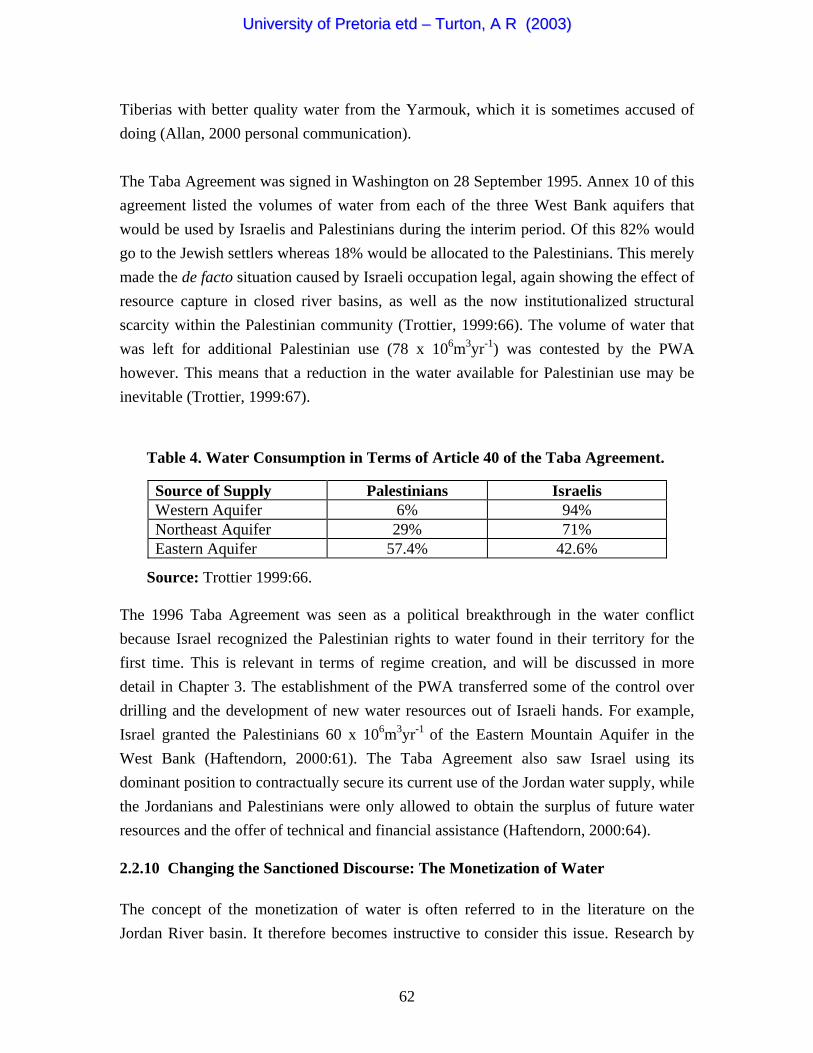
• Lowi calculated the water consumption in the West Bank for 1990 (see Table 2)
(Lowi, 1993:189 in Trottier, 1999:66). It is evident from these data that Israelis are in a favourable position, again illustrating the effect of resource capture in closed river basins with rapidly expanding populations.
Table 2. Percentage of Water Consumption in the West Bank during 1990.
Source: Lowi 1993:189 as cited by Trottier 1999:66.
• In other occupied territories a similar trend is evident. For example, the population density in the Gaza Strip is amongst the highest in the world, being around 700,000 in 1991. These figures are projected to rise to 1.48 million by 2010 (Lindholm, 1995:84). The impact on water resources is profound, but Israel
51
UUnniivveerrssiittyy ooff PPrreettoorriiaa eettdd –– TTuurrttoonn,, AA RR ((22000033))
keeps control in order to prevent salt-water intrusion into the over-abstracted groundwater aquifers that lie under the Gaza Strip.
• By 1993 there were already 97,500 Jewish settlers on the West Bank, with 3,500
in the Gaza Strip and 120,000 in East Jerusalem (Lindholm, 1995:81). This added a new dimension to the water competition, with Palestinians competing firstly against the Israeli state, and secondly against the Jewish settlers. A newspaper report in the Jordan Times noted that water consumption in the Gaza Strip was 44 l/p/d, which is much less than the World Health Organization's (WHO) minimum emergency ration of 50 l/p/d (Lindholm, 1995:84). Yet again this provides evidence of the profound impact of resource capture and resultant structural scarcity in closed river basins that are highly contested.
• By 1985 around 50% of the total cultivated area in Israel was under irrigation
(Lindholm, 1995:63). This represented a 30% growth in irrigated crops since 1965. This was only possible as a direct result of the Israeli hydraulic mission, which greatly improved the security of supply for Israel, but at the direct expense of their Palestinian and Arab neighbours in the Jordan River basin.
Control over water on the West Bank was transferred from the military to Mekorot during 1982, with the purpose of integrating it into the overall Israeli National Water Carrier Project on the instruction of the Minister of Defence, Ariel Sharon (Lindholm, 1995:78). The fact that this instruction came from the military shows to what extent water was regarded as being a strategic asset. In fact, the West Bank aquifer supplied between 25-40% of the overall Israeli supply at that time11 (Starr, 1991:24). Lindholm (1995:81), noting that while figures are contested and differ widely from author to author, concludes that “there is a highly unequal distribution of water, to the disadvantage of the Palestinians”. This also illustrates another important aspect of basin closure and the securitization of water resource management. One element of securitization is the classification of hydrological data. In this case the hydrological data has been classified as secret, which effectively removes it from the public domain (Lesch, 1992:148; Warner, 1996). It also means that independent verification is impossible, so no firm conclusions can be drawn on this issue. The secret nature of hydrological data is a 11 Lindholm (1995:78), who suggests that the lower of the two estimates appears to be more accurate, disputes this figure. Falkenmark (1989a:350) concurs by saying that it is “possibly as much as one fourth”. Lowi (1992:40), supporting the upper end of this scale, states that about 40% of the “groundwater upon which Israel is dependent” originates from the joint Israel-West Bank aquifer system.
52
UUnniivveerrssiittyy ooff PPrreettoorriiaa eettdd –– TTuurrttoonn,, AA RR ((22000033))
manifestation of the securitization of water resource management in closed river basins that are deeply contested such as in the case of the Jordan River basin (Warner, 1996 in Buzan et al., 1998:90). 2.2.6 The Lebanon Invasion and Resource Capture Despite aggressive resource capture by Israel in the occupied territories, water deficit still remained a factor limiting Israeli economic growth potential, providing a strong stimulus to seek alternative sources of supply. This became patently evident during 1977 when the Israeli Water Commissioner, Menahem Cantor, started to regard the Litani River in Lebanon as an option for increasing Israel’s water supply (Lindholm, 1995:75; Nijim, 1990:320). This implied the diversion of the Litani River to Israel. In 1978 Israel established a security zone in Lebanon after the Israel-Lebanon War. This was expanded in 1982 to include the Litani, Hasbani and Wazzani Rivers (Lindholm, 1995:75). Arab commentators link this with the Water Commissioner’s remarks citing this as the cause for the establishment of the security zone. Israel prohibited Lebanese farmers from pumping any water or digging any wells in the security zone without the express permission from the Israel Department of Defence (Lindholm, 1995:76). Tamini (1991:23) states that the Litani water added at least 800 x 106m3yr-1 to the Israeli resources, or about 50% of the Israeli total. It is clear that the Israeli annexation of the Golan Heights in 1981 consolidated its control over the headwaters of the Jordan River, as strategic a resource as the groundwater under the West Bank (Cooley, 1984:15; Lindholm, 1995:58). This also gave Israel strategic control over the East Ghor Canal (Trottier, 1999:59). An important reason for annexation was related to the prevailing military doctrine of defence in depth, but it can also be argued that strategic access to water resources was part of this security equation because through the control of the Golan, Israel could guard against any diversions of the upper Jordan River as well (Lindholm, 1995:70). After the occupation of the Golan Heights, around 35% of the total water supply in Israel now came from that region, illustrating the strategic significance of water as an element of national security in this particular case (Trottier, 1999:59). Under such conditions, the stimulus for resource capture is obviously high. This is only relevant in a closed river basin, showing how water deficit can result in insecurity in the presence of a broader threat perception that sees water as a strategic resource.
53
UUnniivveerrssiittyy ooff PPrreettoorriiaa eettdd –– TTuurrttoonn,, AA RR ((22000033))
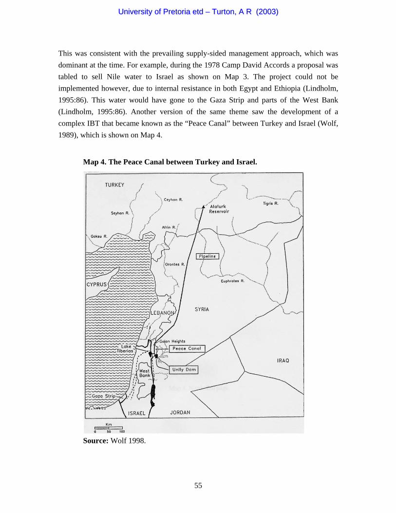
During 1982 Israel expanded the Lebanese security zone to include the Litani, Hasbani and Wazzani Rivers (Lindholm, 1995:75). Both Nijim (1990) and Jaber (1989) put forward the hypothesis that the Lebanon invasions of 1978 and 1982, which resulted in an expanded security zone, were caused by a combination of the need to destroy the Palestine Liberation Organization (PLO) bases as well as improving Israel’s water security (Lindholm, 1995:75). Israeli forces cut off the water supply to Beirut during a siege of that city (Gleick, 1998:129), again providing evidence of the use of water as a strategic weapon. The Lebanese government lodged a protest at the UN in 1984 concerning Israel’s hydropolitics in southern Lebanon, accusing Israel of planning to divert the Litani River. The protest also referred to a similar diversion on the Hasbani and Wazzani Rivers (Lindholm, 1995:76). Israel denied these allegations. 2.2.7 Expanding Horizons: Inter-basin Transfers as a Solution to Basin Closure For various reasons, Israel slowly started to realize that a remedy for its debilitating water deficit might be sought outside of its borders through IBTs (Lindholm, 1995:75). Map 3. Potential Inter-basin Transfer from the Nile to the Jordan River Basin.
Source: Wolf 1998.
54
UUnniivveerrssiittyy ooff PPrreettoorriiaa eettdd –– TTuurrttoonn,, AA RR ((22000033))
This was consistent with the prevailing supply-sided management approach, which was dominant at the time. For example, during the 1978 Camp David Accords a proposal was tabled to sell Nile water to Israel as shown on Map 3. The project could not be implemented however, due to internal resistance in both Egypt and Ethiopia (Lindholm, 1995:86). This water would have gone to the Gaza Strip and parts of the West Bank (Lindholm, 1995:86). Another version of the same theme saw the development of a complex IBT that became known as the “Peace Canal” between Turkey and Israel (Wolf, 1989), which is shown on Map 4. Map 4. The Peace Canal between Turkey and Israel.
Source: Wolf 1998.
55
UUnniivveerrssiittyy ooff PPrreettoorriiaa eettdd –– TTuurrttoonn,, AA RR ((22000033))
This would have seen Turkey emerge as a regional power, using its abundant water resource-base as a political lever. In reality, this would merely have cascaded Israeli hydropolitical insecurity downstream on the Euphrates River into Iraq. The sheer magnitude of these projects shows the degree of desperation that was being experienced by the various riparian states. At the time of writing, none of these projects have been started and they remain unlikely to happen in the near future (if ever). Significantly, it also shows what happens when the core water management problem is defined only in terms of water as a finite resource. 2.2.8 The Significance of Emblematic Events in the Jordan River Basin Emblematic events (Hajer, 1996), or windows of opportunity (Kingdon, 1984), play an important role in hydropolitics, becoming what may be described as a trigger event that serves to change the hydropolitical dynamics in a fundamental way. The Jordan River basin provides a number of examples of this. During the latter part of the 1980s and early 1990s, an emblematic event took the form of massive immigration flows from Russia (Lindholm, 1995:61). These exerted additional pressure on the already stretched water resources of the Jordan River basin and associated groundwater aquifers, becoming a new form of hydropolitical driver. This took place at a time when the effects of a growing economic crisis were entering the public arena. This was centered on the long-term impacts of lenient and excessive government lending policy, which was originally established to encourage agricultural self-sufficiency, but that had attracted too many people to the agricultural sector, resulting in overproduction and inefficiency (Lindholm, 1995:63). For the first time in modern history, sectoral water efficiency (SWE) issues started to become relevant for Israel, with low cost water for agriculture coming under scrutiny (Arlosoroff, 1996). This saw a change in Israeli technology to drip irrigation in order to reduce water consumption and lower the risk of salinization (Lindholm, 1995:65). It also saw the export of this technology, which in turn represented a more efficient use of water as the irrigation components were often made by industrializing kibbutzim that had previously been using water to irrigate their lands. There was a shift away from agricultural to industrial processes - an example of an inter-sectoral allocation policy - with a resultant improvement in the SWE at national level. More significantly however, it created a public debate, allowing the water sector reform that was introduced in the late 1980s, to be consolidated and moved forward (Allan, 2000:190).
56
UUnniivveerrssiittyy ooff PPrreettoorriiaa eettdd –– TTuurrttoonn,, AA RR ((22000033))
In order to try and alter elements of the prevailing political ideology, which equated water as an element of national survival, the Israeli authorities seized this window of opportunity. In its place came a policy that was aimed at changing water use to a higher SWE by means of inter-sectoral allocative efficiency policies (Allan, 2000:136) and the monetization12 of water (Feitelson, 1999). In this regard, the 1990s reform built on the effects of the 1986 water crisis, which led to a significant re-allocation of water as the result of increases in the water price, which in turn had a significant impact on water productivity (Arlosoroff, 1996). The significance of this becomes relevant when one examines the distribution of water in Israel over time. For example, the Israeli water distribution in 1987 was as follows (Lindholm, 1995:62):
• 447 x 106m3yr-1 for domestic use. • 123 x 106m3yr-1 for industrial use. • 1,179 x 106m3yr-1 for agricultural use.
The Israeli Bureau of Statistics reported in 1987 that agriculture was draining 67% of the total water budget (Lindholm, 1995:62). Table 3 shows the consumption of water by the Israeli agricultural sector during 1987-8. Table 3. Agricultural Consumption of Water in Israel 1987/88.
Volume (106m3) Distribution (%) Urban localities 59 5 Moshavot* 58 5 Moshavim* 392 33 Kibbutzim* 484 41 Institutions/farms 24 2 Non-Jewish villages 27 2 Other 135 11 Total 1,179 99 Note: *Moshavot and Moshavim are both small cooperative farms combined with private means of ownership. Kibbutzim are larger, exclusively collective farms.
Source: Central Bureau of Statistics as cited by Lindholm 1995:62.
12 This implies the acceptance by the public that water has purely a monetary rather than an ideological value.
57
UUnniivveerrssiittyy ooff PPrreettoorriiaa eettdd –– TTuurrttoonn,, AA RR ((22000033))
In contrast to this, the consumption of water by Palestinian villages represented only 2% of Israel’s total water consumption during 1987, even though the Palestinian population stood at 19% of the total population in Israel at that time (Lindholm, 1995:63). The distribution of water thus had a major impact on the geography of unequal economic development along ethnic cleavage lines and is one of the pertinent factors that indicate the ethnic power structure in Israel (Ghazi, 1990:331). Yet again this shows the impact of resource capture in closed river basins, because control over such a strategically important resource can be translated into wealth, health and prosperity. Control over, and access to water, thus became directly linked to political power under conditions of basin losure.
, and water recycling has proved the most cost-effective lternative (Shuval, 1987:186).
as thus set for a rapid escalation in hydropolitical onflict between Israel and Jordan.
c In 1986 Israeli policy was initiated to reduce water consumption by the agricultural sector for the first time (Lindholm, 1995:62). In response to a regional water crisis, Israel declared a policy of recycling in 1986, with the stated goal being the re-use of 80% of wastewater by the year 2000 with around 35% of Israeli municipal wastewater being recycled to agriculture and industry (Arlosoroff, 1996; Lindholm, 1995:65). The Israeli re-use is the highest in the worlda Another example of the significance of an emblematic event impacted during a period of Jordanian rhetoric and hydropolitical sabre rattling. King Hussein issued some hostile statements against Israel that were related to a Jordanian application for funding for the Wahda Dam on the upper Yarmouk River for the supply of water to industry around Amman (Lindholm, 1995:73). Israel opposed this request knowing that the World Bank only funds projects where basin-wide agreements have been reached (Starr, 1991:23). The Israeli reluctance exacerbated the Jordanian frustration in light of the increasing levels of water scarcity that were being experienced in the Jordan River basin. Jordan responded by drilling deeper wells instead, thereby seeking to gain access to the aquifers that Israel relied on. The stage wc During this exchange of hostile rhetoric, Israel experienced an extraordinarily dry summer, followed by a dry winter in 1990/1. This was the driest in 70 years and water supply to farmers was reduced by 20% in Israel, and a national water emergency was announced (see Figure 2) (Lindholm, 1995:57). This tended to dampen the conflict
58
UUnniivveerrssiittyy ooff PPrreettoorriiaa eettdd –– TTuurrttoonn,, AA RR ((22000033))
potential as the strategic significance of debilitating water deficit, in what by now was a closed river basin, fell under the spotlight in both countries. Again this focussed the public debate on water sector reform, opening the door further to changes in the hydropolitical ideology by supporting the monetization of water as an essential element
f enduring peace (Feitelson, 1999).
oundation for the eclaration of Principles (DOP) on 13 September 1993.
for water from the uphrates River (Falkenmark, 1989a: 350; Starr & Stoll, 1988:145).
to have. The raeli water dist ib ti n during 1992 was as follows (Lindholm, 1995:62):
• 941 x 106m3yr-1 for agricultural use.
o
As another example of the impact of an emblematic event, the US State Department launched the Middle East Peace Conference in Madrid during October 1991, following the Gulf War (Lindholm, 1995:88). This Conference established five parallel commissions, with one being dedicated solely to water (Trottier, 1999:63). The process got off to a shaky start and finally stalled, partly because Syria and Lebanon refused to participate in the multilateral talks. In an attempt to resuscitate the initiative, secret talks were held in Oslo between Palestinians and Israelis in order to lay the fD During 1992 the Middle East Peace Conference held a multilateral session in Vienna. Israel, Jordan and the Palestinians agreed to cooperate on hydrological data sharing, which had previously been withheld from the Palestinians (Lindholm, 1995:88). This represented the first tangible attempt at generating uncontested and shared hydrological data for the entire Jordan River basin. This data became the foundation of consensus building, illustrating its importance as an element of regime creation. (The relevance of this will be examined in Chapter 3). As part of this emerging peace initiative, Hilel Shuval (1992:139; 1993) tried to revive the so-called “Regional Water for Peace Plan” in the Middle East that would have Nile water transferred to the Gaza Strip (Lindholm, 1995:86) (see Map 3). Jordan also signed an agreement with Iraq E So how important have these emblematic events been on water resource management in a closed river basin such as the Jordan? The Israeli Bureau of Statistics reported that agriculture was still draining 62% of the total water budget during the early 1990s (Lindholm, 1995:62). Although high, it is a significant improvement on the 1987 figures however, showing the impact that the changing water discourse was startingIs r u o
• 479 x 106m3yr-1 for domestic use. • 107 x 106m3yr-1 for industrial use.
59
UUnniivveerrssiittyy ooff PPrreettoorriiaa eettdd –– TTuurrttoonn,, AA RR ((22000033))
The Likud-led coalition government lost power to the Labour-led coalition in June 1992 (Lindholm, 1995:82). Despite the fact that there was an increase in precipitation in Israel at the same time (see Figure 2), this political factor aggravated the West Bank water deficit (Allan, 2000:191; Lindholm, 1995:57). The situation had now changed so much that Israel could no longer survive without the West Bank aquifers, such was the extent of basin closure, and Palestinian independence was perceived as a direct threat to Israel’s water security. This can also be seen as being a new form of emblematic event because it has significant hydropolitical ramifications in a closed river basin where alternative
urces of supply seem to remain politically unattainable.
titutionalized and therefore more predictable, which is clearly a esirable state of affairs.
.2.9 Emergence of a Tentative Water Regime
so This placed the issue of water insecurity high on the national security agenda yet again, providing further evidence of the results of basin closure and the resultant securitization of water resource management. During the third round of the Middle East Peace Conference that was held in Geneva, some progress on water issues was reported (Lindholm, 1995:88). For example, the DOP that were signed between Israelis and Palestinians on 13 September 1993 contained a commitment to cooperate on water issues (Lindholm, 1995:55 & 88-9). One of these issues was the quantification of “equitable utilization” and the establishment of a Water Development Programme. Water was specifically mentioned in Article 7, Annex III, Annex IV of the DOP (Trottier, 1999:63). Annex II specified that regional development would consist of a Mediterranean Sea (Gaza) - Dead Sea Canal (the so-called Med-Dead Canal previously alluded to). It also identifies regional desalination and other water development projects. The principle of “equitable utilization” was accepted in Annex IV. In this regard equitable does not mean equal according to Trottier (1999:64), so the interpretation of this concept is likely to be contested in future. The significance of this new form of contestation is that it is increasingly becoming insd 2 The fourth round of multilateral talks was held in Oman during April 1994 during which the parties agreed to establish a Palestinian Water Authority (PWA) to manage water resources in both Gaza and Jericho (Lindholm, 1995:88). What later became known as the Cairo Agreement, was in fact an extension of the 1993 Declaration of Principles, showing the incremental nature of confidence building measures (Trottier, 1999:64). This
60
UUnniivveerrssiittyy ooff PPrreettoorriiaa eettdd –– TTuurrttoonn,, AA RR ((22000033))
is relevant to a deeper understanding of regime creation and will be dealt with in due course (see Chapter 3). The autonomy of Gaza and Jericho was implemented in May 1994 (Lindholm, 1995:84). The only source of water in Gaza is groundwater from sandstone aquifers, with limited surface water found in Wadis. Around 60 x 106m3yr-1 of renewable water resources are available in Gaza, but 95 x 106m3yr-1 is used annually through over-abstraction (Wolf & Ross, 1992:925). This is clearly unsustainable over time. During 1995 the water table dropped by around 15-20 cm/yr and saltwater intrusion was a problem, already being evident some 1.5-km into the aquifer (Lindholm, 1995:85). Palestinians accused the Israelis of inducing this by pumping water close to the borders. The Israelis in turn accused the Palestinians of causing the problem from over-pumping prior to the Six-Day War (Shuval, 1993:65). The lack of sewerage facilities has led to groundwater contamination affecting health (Lindholm, 1995:85). This provides empirical evidence of what Homer-Dixon (1994:10) calls the ecological marginalization of people, and what Ohlsson (1998:4) calls structural scarcity, as a result of resource capture in closed river basins, which in turn becomes a fundamental driver of conflict.
he relationship between these different concepts is shown in Figure 3. T The Israeli/Jordanian Peace Accords signed on 26 October 1994 contained elements of an attempt to resolve disputes over water allocation (Lindholm, 1995:55). This Israeli/Jordanian Peace Accord saw the division of the transboundary waters being contractually defined for the first time in history (Haftendorn, 2000:61). This is the first discernable element of a regime, the relevance of which will be discussed in due course (see Chapter 3). The issue of water takes up a large portion of the text, so any subsequent regime is likely to have water as a key element (Lindholm, 1995:74). Amongst other issues, agreement was reached over the distribution of the Yarmouk River water, and it was agreed that Israel would divert water from the Upper Jordan basin to the state of Jordan during the summer months. The entitlements of both Israel and Jordan were also agreed to. Article 6 of the Israeli/Jordanian Peace Accord was devoted entirely to water. Of particular significance are the clauses that acknowledge water scarcity as being endemic, with the need to cooperate to jointly develop the resource base. This notes that the need to augment supply is a high priority, opening the door to regional cooperation. It also acknowledged that water development by one party may not harm the interests of another party in the same body of water in keeping with principles of international water law (Trottier, 1999:68). Of significance, no mention is made of water quality in the Yarmouk River. This makes it possible for Israel to substitute polluted water in Lake
61
UUnniivveerrssiittyy ooff PPrreettoorriiaa eettdd –– TTuurrttoonn,, AA RR ((22000033))
Tiberias with better quality water from the Yarmouk, which it is sometimes accused of
ian use (78 x 106m3yr-1) was contested by the PWA owever. This means that a reduction in the water available for Palestinian use may be
Palestinians
doing (Allan, 2000 personal communication). The Taba Agreement was signed in Washington on 28 September 1995. Annex 10 of this agreement listed the volumes of water from each of the three West Bank aquifers that would be used by Israelis and Palestinians during the interim period. Of this 82% would go to the Jewish settlers whereas 18% would be allocated to the Palestinians. This merely made the de facto situation caused by Israeli occupation legal, again showing the effect of resource capture in closed river basins, as well as the now institutionalized structural scarcity within the Palestinian community (Trottier, 1999:66). The volume of water that was left for additional Palestinhinevitable (Trottier, 1999:67).
Source of Supply Israelis Western Aquifer 6% 94% Northeast Aquifer 29% 71% Eastern Aquifer 57.4% 42.6%
The 1996 Taba Agreement was seen as a political breakthrough in the water conflict because Israel recognized the Palestinian rights to water found in their territory for the first time. This is relevant in terms of regime creation, and will be discussed in more detail in Chapter 3. The establishment of the PWA transferred some of the control over drilling and the development of new water resources out of Israeli hands. For example, Israel granted the Palestinians 60 x 106m3yr-1 of the Eastern Mountain Aquifer in the West Bank (Haftendorn, 2000:61). The Taba Agreement also saw Israel using its dominant position to contractually secure its current use of the Jordan water supply, w
Source: Trottier 1999:66.
hile d future water
0:64).
Table 4. Water Consumption in Terms of Article 40 of the Taba Agreement.
the Jor anians and Palestinians were only allowed to obtain the surplus ofesources and the offer of technical and financial assistance (Haftendorn, 200r
2.2.10 Changing the Sanctioned Discourse: The Monetization of Water The concept of the monetization of water is often referred to in the literature on the Jordan River basin. It therefore becomes instructive to consider this issue. Research by
62
UUnniivveerrssiittyy ooff PPrreettoorriiaa eettdd –– TTuurrttoonn,, AA RR ((22000033))
the Harvard Middle East Water Project (HMEWP) showed that the economic value of Jordan River water for agriculture in Israel was $0.20/m3 in 1991. In contrast to this, the 80 x 106m3yr-1 that can be replaced by desalination in the south of Israel based on current technology costs around $0.70/m3. Thus the predicted replacement cost of water for Israel by desalination will amount to US$ 56 million per annum (Shuval, 2000:49). This is not high when one considers the cost of going to war as an alternative approach (Fisher, 1996). The monetization13 of water can thus be regarded as an essential component in the shifting hydropolitical ideology (or sanctioned discourse) of the Israeli-Palestinian conflict. This seeks to reduce the emotional content of denying water to the enemy, and changes the structure of the hydropolitical rationale of water being a low price to pay for potential peace (Feitelson, 1999 personal communication). In essence the discursive elites in this process are trying to gather enough support to legitimize (and therefore sanction) a new discourse on water resource management that differs fundamentally from the old pproach, which was so intimately linked to the hydraulic mission era of the Israeli
which some agreement has now been reached. This provides vidence of the value of uncontested rules and procedures as fundamental components of
aNational Water Carrier Project.
Another element of this is related to the changing international water resource management paradigm that is based on the Dublin Principles (ICWE, 1992) and World Water Vision (Cosgrove & Rijsberman, 2000), which see water as an economic good with monetary value if the management thereof is to become sustainable over time. This long-term sustainability is particularly relevant in a closed basin such as the Jordan River. During 1997 Jordan also began a radical transformation of the water sector, raising prices closer to real costs, initiating privatization of the water supply and distribution system in Amman, and pressurizing water users to pay for services. Efforts were also launched to reduce losses in the water supply system, which were reported to be as high as 50% (Gleick, 1998:117). These changes are the result of the agreement with Israel that removed some of the uncertainties in water supply, showing the value of regimes as confidence-building mechanisms (see Chapter 3). One of the sensitive issues is the siting of a diversion dam on the Yarmouk River near Adassiyah to divert flow to Jordanian agricultural projects, for eregimes (see Chapter 3).
Associated with this was the 1997 UN approved version of the International Law Commission (ILC) report that gives priority to the rights of historical or prior use, and
13 This is what Feitelson (1999) refers to as the “commodification” of water.
63
UUnniivveerrssiittyy ooff PPrreettoorriiaa eettdd –– TTuurrttoonn,, AA RR ((22000033))
considers depriving a downstream riparian state that currently uses the water for economic and social purposes as unacceptable since it will result in “appreciable damage” to the current user (Eckstein, 2002:85; Shuval, 2000:48). This gives some degree of assurance to downstream riparian states like Israel that there is recourse to legal solutions if needed. At least it suggests that during negotiations on the issue, the moral
igh ground will be given to those arguments that are couched in legally acceptable
lan, 2000:215). Significantly, these rategic alternatives can only be considered when water resource management is no
2.2.11
hprinciples.
The election of Ehud Barak as the Israeli Prime Minister in 1999 gave the peace talks a boost at a time when the normative basis of the management of international river basins was starting to change at the global level. This was in conjunction with Syrian President Hafas El Assad’s statement that it is Syria’s strategic goal to achieve peace with Israel based on the principle that “territories taken by force in war should be returned as a condition for peace”. US President Bill Clinton underscored these initiatives during December 1999 (Shuval, 2000:40). The subsequent reopening of the peace talks between Syria and Israel raised the issue of water in the upper Jordan basin in a relevant and timely fashion (Shuval, 2000:40). A drought was also experienced in the region (see Figure 2), providing an ideal backdrop to the apparent new desire to cooperate. Until this drought, irrigated agriculture consumed 71% of the water in Jordan, and 66% of the water in Israel (Trottier, 1999:70). This drought started to change the perception that water on its own is a strategic resource, and grain importation policies were considered to be a remedy for the first time, in keeping with the virtual water thesis (Allan, 2000:33). This represents a shift in focus away from first-order issues to second-order issues for the first time in the Jordan River basin, with the monetization of water as a central component to this shift. This virtual water trade has now started to become significant, with Jordan importing 91%, and Israel importing 87% of their respective grain needs (Postel, 1999 as cited by Trottier, 1999:70), meaning that in effect the water deficit in the Jordan River basin is now being balanced through trade rather than by means of the large transfers of water that were envisaged on Maps 3 & 4. It is this trade in virtual water that has prevented a further escalation in the conflict (Alstlonger perceived as being a national security issue.
Discussion: Basin Closure and Increasing Levels of Insecurity
“The concept of resource vulnerability has been associated with the inability to sustain economic and social activity commensurate with a region’s goals
64
UUnniivveerrssiittyy ooff PPrreettoorriiaa eettdd –– TTuurrttoonn,, AA RR ((22000033))
… Thus, a nation may be said to be water vulnerable if its capacity both to sustain its aquatic ecosystem and to provide its population with a desired level of economic and social development, is compromised by the nature of the hydrologic system, its water resources infrastructure or its water
sue, given the rapid growth of population in
nd the utilization of
ealed the following patterns of water o 6:197):
r /p/yr
management system” (Raskins, 1997:22). It can be seen from the Jordan River case study that access to water was one of the factors that were considered in defining the state borders of Israel, but not the only factor (Lindholm, 1995:60; Medzini, 2001:193). Salmi (1997:15) goes further than this by concluding that one of the critical elements in the overall problem surrounding water and conflict in the occupied Palestinian territory (and broader Middle East) is the “limited water resources themselves, which, in this semiarid region, are vital for development and impinge on wider security issues for all countries in the region”. Güner (1997:105) concurs with this view, adding that “the scarcity of water in the
iddle East is a deeply rooted security isMthe region and global climatic changes”. Because water was one of the major issues that were of concern when the modern state of Israel was being formed, it became a fundamental component of the respective ideologies that are at work in the Arab-Israeli and Israeli-Palestinian conflicts. An element of this was the need to expand the absorptive capacity in order to support the growing immigrant numbers over time. The Israeli need for water for the country’s highly advanced agricultural sector, and the joint dependency of Israel and the West Bank on the River Jordan and the groundwater aquifers in the highlands of the West Bank, are crucial factors to the Israeli occupation (Lindholm, 1995:55-7; Wolf, 1996). The growing
opulation has exerted considerable pressure on natural resources, apwater has now reached its limit (Lindholm, 1995:57). Falkenmark (1986:197) has used the Jordan River basin as a benchmark for the development of the concept of the water barrier, because it is such an extreme example. This was done by taking statistical data that provided an indication of water consumption
er capita from various countries, which revpc nsumption (Falkenmark, 198
• Iraq uses 4 400 m /p/yr 3
3
• Pakistan uses 2 200 m /p/y• Syria uses 1 300 m3
65
UUnniivveerrssiittyy ooff PPrreettoorriiaa eettdd –– TTuurrttoonn,, AA RR ((22000033))
• Egypt uses 1 200 m3/p/yr
• Israel uses 500 m3/p/yr
apita and conomic development potential by using the Jordan River basin as a baseline.
on pressure in a short period of time, causing additional difficulties indholm, 1995:80).
• India uses 800 m3/p/yr
Taking the case of Israel as an example, Falkenmark (1986:197) concluded that a realistic level for a developing state is 500 m3/p/yr as this would allow 100 m3/p/yr for domestic and industrial use leaving the remaining 400 m3/p/yr (80% of the total) for irrigation. This is considered to be the water barrier beyond which development is not possible under levels of currently available advanced technology. This implies that the water barrier may change as new technologies become available, but these advanced technologies are normally not available to developing states, which will be discussed in more detail in Chapter 3. As such it shows how access to, and control over technology, can become a competitive element in a closed river basin. It also implies that in certain developing countries such as in the Palestinian proto-state, where technological access is low and the population burden is high, a type of threshold may be reached beyond which sustainable development is simply not feasible. It is therefore highly relevant that Falkenmark (1989b) has developed her benchmark of water consumption per ce Population is therefore a key factor in understanding the hydropolitical dynamics of closed river basins. The population is growing in the Jordan River basin due to a large birth rate in the Arab sectors, as well due to the resettlement of Jews from elsewhere in the world, such as from the former Soviet Union (USSR). A potential Palestinian state will presumably also see the massive influx of refugees from neighbouring states, increasing the populati(L The West Bank, Gaza and Jordan have reached the water barrier (Falkenmark, 1990:181). These areas can simply take no more people without drastic measures being taken to secure the availability of potable water. Despite the fact that Israel is exploiting all of its mean annual runoff (MAR), recycling all of the sewerage discharge, and recycling 30% of the urban waste to agriculture, there is still a gap of between 200 - 300 x 106m3yr-1 (Clarke, 1991; Lindholm, 1995:57). This makes water scarcity a fundamental problem of survival in the region, thereby elevating it to the level of a strategic issue for the respective governments, establishing the Jordan River basin as an excellent case study of
66
UUnniivveerrssiittyy ooff PPrreettoorriiaa eettdd –– TTuurrttoonn,, AA RR ((22000033))
the results of basin closure. Tables 5 & 6 indicate the extent of the water scarcity in
West Bank
Israel, Jordan and the West Bank.
Israel Jordan 375 x 106m3/yr 175 x 106m3yr-1 135 x 106m3yr-1
J West nk Israel ordan BaWater Supply 1987 - 1991 Under normal conditions 1,950 900 650 Under drought conditions 700-750 450-550 1,600 Water Demand 1987 - 1991 2,100* 800 125† 2020 2,800 1,800 530 Notes: * Including settlements in the occupied territories and the Golan Heights. † The Arab population of the West Bank.
Source: Lowi 1992:34 as cited by Lindholm 1995:59.
From Tables 5 & 6 it is evident that projected demand is in excess of supply and that the
Table 5. Expected Water Shortage in 2010 Based on the 1991/2 Israeli Drought Data.
: Kally 1991:11 as cited by Lindholm 1995:58.
6m3yr-1).
Source
Table 6. Water Supply and Demand, Present and Future (10
Jordan River basin is closed. Due to the heavy reliance on groundwater in the region, there is also salt-water intrusion into the aquifers. Given the fact that the salinity of the static water belts is in principle higher than the salinity of the sea, these salinization processes are irreversible (Lindholm, 1995:66). This is an example of a threshold effect in water resource management. These various aquifers are so interconnected, that they cannot realistically be managed as individual entities, establishing a permanent linkage between the respective communities (see Maps 1 & 2). One aspect of this issue is about which social grouping exercises control over the aquifers? Excessive drilling on the West Bank can cause irreversible salinization of the Israeli water system. A Palestinian state on the West Bank is thus considered to be a serious threat to the water security of Israel, and excessive drilling may be a casus belli for Israel (Lindholm, 1995:66). This is one of the reasons why control over the West Bank is so hotly contested. In this regard, because the West Bank is a
67
UUnniivveerrssiittyy ooff PPrreettoorriiaa eettdd –– TTuurrttoonn,, AA RR ((22000033))
future Palestinian homeland, and because it is perched above an aquifer that is strategically important for Israel, a bilateral agreement and joint management of the aquifer is an absolute necessity (Lindholm, 1995:84; Wolf, 1996). Current Palestinian water scarcity is a direct result of Israeli military occupation and has characterized all facets of life on the West Bank since the Six-Day War. Furthermore, Palestinian griculture has been made dependent on the Israeli-controlled water allocation system
f which simply cascaded erceptions of increasing insecurity elsewhere in the river basin (Lesch, 1992:148 in
ed Jordanian fears that their agricultural production would be damaged by the flux of seawater, heightening their desire to gain direct control over a jointly shared source.
athat was established by military occupation (Lindholm, 1995:82). This has led Amery (1997:95) to conclude that the desire to secure water use and supply from the West Bank aquifers and from the Jordan River and its tributaries, contributed to Israel’s decision to occupy the West Bank and Golan Heights during the 1967 Six-Day War, and the security zone in south Lebanon during the 1978 invasion of that country. This is consequently an extreme example of the results of basin closure, from which a number of lessons may be learned. One lesson is the fact that the Israeli economy has grown in an arid environment without any significant oil revenue (Allan, 2000:79). This was only achieved through the aggressive application of resource capture policies, leading ultimately to the institutionalization of structural scarcity, the securitization of water and the classification of hydrological data, all opLindholm, 1995:89; Warner, 1996 in Buzan et al., 1998:90). The Dead Sea is a source of bromine and potassium, and as such forms a strategically significant part of the Israeli industrial complex. Due to the heavy over-abstraction of water from the Jordan River basin upstream of the Dead Sea, the level has fallen, resulting in the collapse of ecosystems. This threshold effect has introduced an ecological dimension into the overall security equation of the Jordan River basin, raising serious questions about sustainability over time. This poses a threat to Israel, and is one of the reasons why the canal between the Mediterranean and the Dead Sea (the so-called Med-Dead Canal) was planned in the late 1970s (Lindholm, 1995:72-3). This will generate hydroelectric power that will be used to power the desalination plants at Ashod. This in turn provokinre
68
UUnniivveerrssiittyy ooff PPrreettoorriiaa eettdd –– TTuurrttoonn,, AA RR ((22000033))
2.2.12 Conclusion Regarding the Consequences of Basin Closure From this overview, a tentative model that shows the interrelationship of the various concepts and drivers can be developed (see Figure 3). The Jordan River basin case study
rovides an insight into some of the hydropolitical dynamics related to basin closure,
ns interpret vents through their own prevailing threat perception, and translate this into a perceived
esulting directly from perceptions of insecurity, the process of securitization starts to unfold.
chnology, where a riparian state will mobilize the best vailable technology in order to improve its position as much as possible in a
ter Carrier Project, the ordanian East Ghor Canal, the mooted 1959 Arab League Diversion Plan and the
planned Israeli diversion of the Litani River in Lebanon.
pwhich can be distilled into a number of distinct issues. Arguably the central issue is that of insecurity which results from basin closure. In this regard it is more accurate to conclude that perceptions of insecurity are really more important than actual insecurity, because it is these perceptions that drive political decision-making. Central to this whole process of increasing levels of insecurity is the aspect of threat perception. It can be said that threat perceptions are forged from a wider set of political experiences that converge to create a specific way in which the relevance of water deficit is interpreted by gate-keeping elites. Insecurity is also caused by competing demands on a limited and dwindling resource-base. In this case powerful gate-keeping political elites translate this perception of insecurity into an active policy of resource capture. As security of supply is assured to one group of people (or state) in a closed river basin, insecurity is merely cascaded downstream to other potential users of the same scarce resource-base. Under these conditions the most likely result of this set of hydropolitical dynamics is a zero-sum outcome, when downstream ripariaenational security concern, which in turn results in a high conflict potential. R
This has a number of key elements to it.
(a) One key element is teagiven closed river basin. (b) This can be manifest in what can be described as a first-order (hardware) approach where major water infrastructure is developed as a form of supply-sided management approach to the perceived problem. The Jordan River basin has elements of this in the form of the Israeli National WaJ
69
UUnniivveerrssiittyy ooff PPrreettoorriiaa eettdd –– TTuurrttoonn,, AA RR ((22000033))
(c) This is also manifest in what can be described as a second-order (institutional) approach where hydrological data becomes the key focal point. In the Jordan River basin this saw the classification of key hydrological data by the Israeli government (Lesch, 1992:148 in Lindholm, 1995:89; Warner, 1996 in Buzan et al., 1998:90). Data therefore becomes a focal point of conflict in closed river basins, where a technologically advanced riparian will gather, interpret and use data to their advantage, while deliberately withholding it from their hydropolitical rivals. Under these conditions, knowledge is power, and it is wielded like a weapon to achieve and maintain hegemonic control.
in ase study reveals the systematic use of resource capture. Some of these examples are:
the resource being aptured was land, but land without water has limited value.
promulgated in 1950 reinforced this arly form of land-based resource capture.
esource had already been captured. It is after all water at gives land its value.
Territories, tipping the hydropolitical balance of power firmly in favour of Israel.
The results of the first two issues noted above act as a fundamental driver for the third key issue that manifests itself in closed river basins. Resource capture is one of the main responses by the hegemonic power within the closed river basin. The Jordan River basc
(a) The phenomenon of the landless Arab peasant that started to emerge as early as 1920 before the state of Israel even existed. In this casec (b) The Absentee Property Law that wase (c) The 1959 Water Law saw water becoming the main focus of resource capture, now that the land-based rth (d) Military Order No. 158, imposed after the Six-Day War, consolidated control over the development of groundwater, thereby strengthening the water-related resource capture in the Occupied
The fourth key issue is related to population growth. In the Jordan River basin it is evident that rapidly growing populations from various riparian states and stakeholders, formed separate political constituencies. These growing populations need to be fed, housed and given jobs, all of which places a severe and escalating strain on a dwindling
70
UUnniivveerrssiittyy ooff PPrreettoorriiaa eettdd –– TTuurrttoonn,, AA RR ((22000033))
water resource-base in a closed river basin. This results, over a period of time, in water becoming a strategic issue, as the economic relevance of water is realized by the
ecision-making elites.
as manifest in the Jordan iver basin case study, has a number of distinct elements to it.
aspora, and making the desert bloom as a anifestation of that resettlement.
the otherwise inhospitable Negev esert in order to provide security outposts.
rowth is generally stagnant, and where opulation growth is a significant factor.
d Due to the strategic significance of access to, and control over water resources in a closed river basin, there is a strong impulse to develop and articulate a hydraulic mission in society. This hydraulic mission becomes the manifestation of a form of hydropolitical ideology that is underpinned by a strongly articulated sanctioned discourse. It therefore starts to act as a fundamental driver in its own right, simply because it results in institutional development, legal development and other related long-term outcomes, or what might be called revenge effects. This hydraulic mission,R
(a) There is an ideological dimension to it in the strictly political sense of the word. An example of this is the basic Zionist ideal of settling the land again as a symbolic return of the Jewish Dim (b) There is also a security element to it. In the case of Israel, the defence doctrine was based on notions of depth, which was simply not possible with the limited land that was available to the new state of Israel in 1948. Another element was the use of water to sustain Jewish settlements inD (c) There is also an economic element to it. In the Jordan River basin case study, control over water resources is a foundation for potential economic growth and prosperity, in a region where economic gp (d) There is finally a punitive element to it that is based on the use of water as a political tool, or in extreme cases, as a weapon of war. In the Jordan River basin case study, numerous examples can be found, the most notable of which was the 1959 Arab League Diversion Plan, which sought to deliberately deny water to Israel. The deployment of Palestinian Al Fatah guerillas by Syria to disrupt the Israeli National Water Carrier Project (Lindholm, 1995:69) occurred along the same lines. The Israeli bombing of the hydraulic works for the proposed Arab
71
UUnniivveerrssiittyy ooff PPrreettoorriiaa eettdd –– TTuurrttoonn,, AA RR ((22000033))
League Diversion of the Jordan River is also a vivid example (Gleick, 1998:129). The different depth of Palestinian and Jewish settler wells in the occupied West
ank as prescribed by law is another harsh example (Lindholm, 1995:80).
y, ith all riparians claiming sovereignty over the source of water at some point in time.
d gnificantly alter the hydropolitical balance of power to the detriment of Israel.
flows into downstream rael by virtue of the laws of physics (Shuval, 2000:48).
belief that the upstream riparian state can shut off the supply in times of hostility.
nique features of water in closed river basins. he most notable of these are extremes of:
) Water as a casus belli with a high pay-off zero-sum outcome.
n of war or a political tool to be wielded with aggression in is zero-sum game.
nfiguration, to one of a plus-sum outcome based on operation instead.
B
Water and sovereignty issues are clearly evident from the Jordan River basin case studw
(a) One of the best examples of this is control over the aquifers that are found under the occupied West Bank, which if left to Palestinian control, woulsi (b) Another example is the rationalization that the water in the Jordan River is in fact “Arab Water” because it falls on Arab soil and merelyIs (c) This raises the significance of endogenous versus exogenous water. A state is highly vulnerable if it depends on exogenous water for its strategic water supply, raising perceptions of insecurity, which are fuelled by the
The Jordan River basin case reveals some uT
(a (b) Water as a weapoth (c) Water as a potential catalyst for peace, as riparian states slowly realize that they are linked to one another by virtue of their interdependence on the resources found in a shared international river basin, for which no other viable alternative can be found, and that their best long-term interests are served by changing the zero-sum political coco
72
UUnniivveerrssiittyy ooff PPrreettoorriiaa eettdd –– TTuurrttoonn,, AA RR ((22000033))
(iv) Central to these unique features is the role of emblematic events in enabling
ay as both a confidence-building mechanism, and a central lement for the de-escalation of perceptions of insecurity in a highly contested, closed
f the most fundamental outcomes of river basin losure, namely the rise in perceptions of insecurity, and in particular those experienced
the sanctioned discourse to be re-examined, and where appropriate, changed.
Significant to the Jordan River basin case study is the role of basin-wide planning and water sector institutional development as a confidence-building mechanism, in an otherwise extremely hostile political arena, in which the language of compromise is usually seen as a sign of weakness. Central to this is the role that uncontested hydrological data can pleinternational river basin. Finally, it can be concluded that the economically most developed state, with the greatest technical capacity, tends to monopolize access to the resource base in a closed river basin, in an attempt to improve their own security of supply. Such a state will tend to become hegemonic, resulting in the cascading of insecurity elsewhere in the closed river basin. This can be regarded as being one ocby lower-order riparian states, over time. Figure 3. Securitization Model.
Water Deficit ternational
River Basin
in an In
Strong Perceptions of Insecurity
Threat Perceptions Fuelled by the Broader
Political Setting
Strongly Articulated Hy
Structural Scarcity or Ecological
Marginalization
Institutionalized Resource Captur
e
draulic Mission M n
Hydrological Data (Knowledge is Power)
obilization, Interpretatioand Classification of
Endemic Conflict
Well Defined Sanctioned Discourse
73
UUnniivveerrssiittyy ooff PPrreettoorriiaa eettdd –– TTuurrttoonn,, AA RR ((22000033))
2.3 Securitization as a Consequence of Increasing Levels of Insecurity One of the fundamental outcomes of river basin closure is an escalation in the level of insecurity as perceived by the various riparian states as shown in the review of the literature relevant to the Jordan River basin. It therefore becomes necessary to understand the hydropolitical dynamics that are at work under such conditions. Central to this is an understanding of the processes of securitization and potential desecuritization of issues,
hich is possible by means of security complex theory (SCT) that is being developed by zan & Wæver (forthcoming).
(Agence de l’Eau, 2000; Cosgrove & Rijsberman, 2000; an Hofwegen & Svendsen, 2000). This has become linked with national security, for as
Du Pl
wBuzan (1988; 1991; 1994), Buzan et al (1998) and Bu 2.3.1 Introduction to Security Complex Theory When the Berlin wall fell and the Cold War ground to a halt, a new wave of optimism engulfed the entire planet. It seemed, at least for a moment in time, that there was cause for a new optimism, and for some that history itself had reached its logical end (Fukuyama, 1992). This short-lived optimism quickly saw a scramble for post-Cold War political hegemony, and a new global agenda started to emerge. In this process, two things occurred. The first was the expansion of the notion of security (Buzan, 1991; Buzan et al., 1998; Buzan & Wæver, forthcoming) that brought with it the central concepts of securitization, securitizing actors, referent objects and security complexes. The second was the birth of a globalizing discourse with a number of key ramifications, one of which is the emergence of, “environmental issues [which] symbolize … the most salient features of the post-Cold War world” (Rodal, 1996). One subset of these environmental issues is the emergence of a powerful global discourse for the management of water resourcesv
essis (2000:13-14) notes:
“[T]he water discourse is concerned with, and inextricably linked to, the concept of security. This concern extends to environmental security in general, and to water security in particular. This latter focus, and its collateral theoretical conceptualizations, are forced upon the scene by specifically linking the water discourse … to the war/peace and conflict/cooperation [problematique], and by considering water to be a potential source or cause of (violent) conflict. ... The result is the emergence of a new strategic imperative expressed by the term environmental security. This addresses the environmental factors behind potentially violent
74
UUnniivveerrssiittyy ooff PPrreettoorriiaa eettdd –– TTuurrttoonn,, AA RR ((22000033))
conflicts, and the impact of global environmental degradation on the well being of societies and economies (Porter, 1998:215). This development is, in part, the result of the ‘new’ security paradigm that has broadened and deepened the security agenda by including non-military (‘low-politics’) threats, as well as non-state, security stakeholders at all levels of society. Hence, it is also linked to the notion of common security, which has as its foundation common interests that, at a minimum, requires a shared interest in survival (Butfoy, 1997:126). Irrespective of the fact that post-1989 security has acquired a wider meaning than protection from military threat, its broader conceptualization has paradoxically contributed to the securitization and militarization of water as a traditional non-military
as an analytical tool.
concern”. Growing public awareness of environmental concerns has not only shifted our awareness of the environment, but also how we perceive the world of capital (Fine, 2001:27). In fact, the rise of the environmental movement contributed fundamentally to a widening of the concept of security (Buzan et al., 1998:2), to the point of being seen by some as the “ultimate security” (Myers, 1993). In short, from a water sector perspective, the environment and related issues are becoming securitized, which is particularly true in closed (or closing) river basins (Gebramendhin, 1991; Hjort af Ornas & Salih, 1989;
1993). This literature review seeks to Mathews, 1989; Myers, 1986; Myers, 1989; Myers,examine some of the ramifications of this, using SCT 2.3.2 An Overview of Security Complex Theory The fact that the Cold War was won by accelerating the arms race, rather than by the actual use of those arms, emphasized the importance of expanding the concept of security (Allan, 2000:244). Buzan et al (1998:2) note that the rise of a globalized environmental movement, along with other transnational issues such as crime, have also contributed to the widening of the concept of security. However, security is a relational phenomenon, so consequently one cannot understand the national security of any given state without understanding the international pattern of security interdependence in which it is embedded (Buzan, 1991:187). Comprehensive security analysis calls for focus on how the regional level of political interaction mediates the interplay between states and the
ternational system as a whole (Buzan, 1991:188). This has meant that regional political ininteractions are only now starting to become manifest in the post-Cold War era. The idea of a regional system has been historically linked to Europe and its inherent balance of power dynamics (Buzan, 1991:188). Even the massive process of
75
UUnniivveerrssiittyy ooff PPrreettoorriiaa eettdd –– TTuurrttoonn,, AA RR ((22000033))
decolonisation, which should have caused attention to be given to emerging regional security sub-systems, was unfortunately overshadowed by the global superpower rivalry. By focusing on regional subsystems, two important levels of analysis between system and the state are possible: the subsystem itself; and the pattern of relationships among the
arious units that make up that subsystem (Buzan, 1991:188).
e depicted as a spectrum of possible lationships as shown schematically in Figure 4.
v Consequently, Buzan et al (1998:201) have developed the concept of a security complex that embraces these key levels of analysis. While securitization of water is not necessarily a desirable outcome of water resource management, the concept does help us to understand political linkages between states in shared international river basins. In particular, the concept allows an understanding of the process of securitization arising from basin closure to be developed. Security complexes emphasize the interdependence of both rivalries and shared interests that can bre
Negative Positive
C Fear, rivalry and
Väyrynen, 1984)
Security Regimes
se (Jervis, 1982)
Pluralistic Security
Use of force not
(D ., 1957:1-4)
onflict Formation
utual threatm perceptions
(Senghaas, 1988;
Negotiated arrangements to
reduce the shared curity dilemma
Community
anticipated eutsch et al
Figure 4. The Security Complex Spectrum.
Source: Adapted from Buzan et al., 1998:12.
Significantly, security complexes are merely analytical devices, being an empirical phenomenon with both historic and geopolitical roots. In fact, security complexes do not require that their members think in terms of this concept - as such they are not actor-defined conditions - but rather analytical tools (Buzan et al., 1998:20). Due to the fact that threats are greater over shorter distances, security interactions with neighbours tend to assume a higher priority. Therefore, seen from the top down, security complexes are generated by the interaction of anarchy and geography, where the political structure of anarchy confronts all states with a security dilemma (such as that resulting from water deficit in a closed international river basin as demonstrated in the Jordan River case study), but this is almost always mediated by the effects of geography (Buzan, 1991:191). The reality of security complexes can be found more in the patterns of amity and enmity
76
UUnniivveerrssiittyy ooff PPrreettoorriiaa eettdd –– TTuurrttoonn,, AA RR ((22000033))
between states, than in the notion of self-awareness. Like the balance of power, a security complex can exist regardless of whether the individual actors recognize or acknowledge its existence (Buzan, 1991:192). A security complex occurs where a set of security relationships stands out from the general background by virtue of its relatively strong, inward looking character, as well as by its relatively weak outward security interactions with its neighbours. The boundaries between security complexes are defined by relative indifference towards security perceptions and interactions (Buzan, 1991:193). A central feature of the emergence of security complexes is the impact of what is known as overlay, which is that condition that prevails when the direct presence of outside powers in a region is strong enough to suppress the normal operation of security dynamics among the local states (Buzan, 1991:198). Overlay thus subordinates local security dynamics, which once removed, tends to become a transforming experience, unleashing new interactions over time. As such, overlay has had a major impact on regional security complexes, most notably the result of European and Japanese colonialism in the Third World. The process of colonialism ended at about the same time that superpower rivalry emerged after the Second World War, meaning that one form of overlay was merely replaced by another, thereby continuing to suppress the emergence of
Source: Buzan 1991:210.
lexes in the Third World. Map 5. Security Comp
77
UUnniivveerrssiittyy ooff PPrreettoorriiaa eettdd –– TTuurrttoonn,, AA RR ((22000033))
more visible local security dynamics. This means that overlay has had a significant impact on the study of security relationships, particularly in the developing world. With the demise of the Cold War, a number of regional security complexes are starting to emerge (Buzan, 1991:202-209). This led to early attempts to identify security complexes that were emerging in the Third World, such as the Latin American Security Complex; the Middle East Security Complex; the Southern African Security Complex; the South Asian Security Complex; and the Southeast Asian Security Complex (see Map 5)
uzan, 1991:210).
ations and confederations interacting cross the political, economic and societal sector.
(B Security is about understanding political interactions in a wider context. Therefore, international security is about relationships between threats and vulnerabilities, which are most marked in a regional setting. The rather unique case of rising perceptions of insecurity that can occur in closing international river basins provides one such setting, as demonstrated in the Jordan River case study. Consequently, and in an attempt to accommodate this issue of proximity on security perceptions, Classical Security Complex Theory (CSCT) (Buzan, 1991:186-229) posits the existence of regional sub-systems as objects of security analysis and offers a framework for dealing with this (Buzan et al., 1998:10-11). While CSCT had the advantage of drawing attention away from the extremes of national and global security by focussing attention on mediating regional political interaction, it is still incomplete as an analytical approach (Buzan, 1991:186-229; Buzan et al., 1998:14). For this reason Buzan et al., (1998) move beyond CSCT, because that specific approach is too narrow in focus (states only), with a bias towards military and nuclear threats and threat perceptions. Instead they make the case for widening the conceptual net in order to increase the range of issues and sectors that can be analyzed in a meaningful way. In this process of widening, they distinguish two generic types of security complexes (Buzan et al., 1998:16). These are homogenous security complexes such as studies of power rivalries among states using terminology such as “military complex”; and heterogeneous security complexes such as studies focusing on states, nations, transnational corpora Due to the fact that heterogeneous security complexes have the advantage of linking across sectors, the analyst is able to build up a more detailed understanding of complex political dynamics by identifying linkages between sectors (military, economic, societal, environmental etc.), units (states, nations, multinational corporations etc.) and levels (local, national, regional and global). In order to achieve this, scientific discipline is
78
UUnniivveerrssiittyy ooff PPrreettoorriiaa eettdd –– TTuurrttoonn,, AA RR ((22000033))
obviously needed, for without it, “the security of each is related to the security of all, [so] nothing can be fully understood without understanding everything” (Buzan, 1991:187). By taking a social constructivist approach to the understanding of the processes of securitization, Buzan et al (1998:19) move beyond this dilemma. Central to this is the
ay in which two key questions are answered:
How to identify and distinguish security actors and referent objects?
generate endorsements of emergency measures beyond rules that ould otherwise bind.
w • How to identify what is (and what is not) a security issue? • This wider approach to security achieves two things (Buzan et al., 1998:4). Firstly, the wider agenda extends a call for state mobilization to a broader range of issues. This can have undesirable or unintended consequences however, as the case for the securitization of water resource management at the global level shows (Wester & Warner, 2002:61). Secondly, the wider agenda elevates security to a common good. Wæver (1995) warns that this may be dangerous, calling for the desecuritization of issues wherever possible and appropriate. However, there is a clear set of criteria for something to be considered as a security issue. Buzan et al (1998:5) state explicitly that certain criteria distinguish normal political issues from security issues. For something to become relevant in a security context, the issues must be staged as an existential threat; this threat must be posed to a referent object; a securitizing actor must perform this securitizing action; and the intention must be to w
Unit as envisaged by Buzan et al (1998:36) Use in Study Referent Objects - things that are seen to be existentially threatened that have a legitimate claim to survival. ica,
Perceptions of economic and social stability by the political elite of a specific riparian state (e.g. South AfrNamibia, Botswana, Swaziland, Mozambique, Lesotho, Zimbabwe).
Securitizing Actors - actors who securitize issues by declaring a referent object as being a lead actor existentially threatened.
Affected riparian state in a given international river basin, orthat is not a riparian state.
Functional Actors - actors who affect the dynamics of a sector without being the en
basin, or an interested third party).
Non-affected riparian state (often in a high order riparian position in a giv
referent object or securitizing actor. Source:
Table 7. Types of Units Involved in Security Complex An
Adapted from Buzan et al., 1998:36.
alysis.
79
UUnniivveerrssiittyy ooff PPrreettoorriiaa eettdd –– TTuurrttoonn,, AA RR ((22000033))
Table 7 presents the types of units involved in SCT, along with an indication of the relationship between key concepts and the way that these will be applied to the South
frican case study (see Chapters 4 & 5).
me; and the distribution f power between the principle units (Buzan et al., 1998:13-14).
ur main structural options re evident (Buzan, 1991:216-220; Buzan et al., 1998:13-14):
mean that those changes tend to support rather than undermine the prevailing structure.
tion, changes in the distribution of power or changes to e pattern of amity and enmity.
ave the complex, or the overall distribution of power, amity and enmity is vident.
A Seen in this light, security complexes become sub-systems or mini-anarchies in their own right (Buzan et al., 1998:13). However, because they are durable manifestations of inter-state behavior, seeing them as sub-systems with their own pattern of interaction provides a useful benchmark against which changes in the security patterns can be identified over time. Having established the fact that security complexes are useful objects of analysis, Buzan et al (1998:13-14) identify the three main components of the essential structure of any given security complex. Essential structure is the standard by which change can be measured in a given security complex (Buzan, 1991:211). The main components of essential structure are the arrangement of units and the differentiation between them; the patterns of amity and enmity that exist between those units over tio Changes bearing on any given security complex are numerous and continuous. For this reason, the key analytical question to ask is how such changes work to either sustain or alter the essential structure of the security complex, of which foa (a) Maintenance of the status quo means that the essential structure of a given security complex remains fundamentally intact over time. This does not mean that change does not occur, but it does
(b) Internal transformation of a given security complex occurs when the essential structure changes within the context of the existing outer boundary. This can occur as the result of regional political integrath (c) External transformation of a given security complex occurs when the essential structure shows change in the existing outer boundary. This can occur when major states join or lee
80
UUnniivveerrssiittyy ooff PPrreettoorriiaa eettdd –– TTuurrttoonn,, AA RR ((22000033))
(d) Overlay can be the cause of change within a given security complex when one or more external powers move directly into, or out of that complex. This situation is distinct
om the normal process of great power intervention.
arian states (Buzan et l., 1998:11). This is evident in the Jordan River basin case study.
anging perceptions of insecurity that may e found in a closing international river basin.
onal relations, there are five commonly used vels of analysis (Buzan et al., 1998:5-6):
onglomerate of interacting or dependent units that have no system level above them.
n of frican Unity - OAU) and the Southern African Development Community (SADC).
fr Security complexes can be treated as objects for policy in the sense that problems can only be resolved within the context of the relevant security complex as a whole (Buzan, 1991:225). This introduces the valuable notion of proximity, or stated differently, geographic focus, which is clearly relevant in an international river basin in which rising perceptions of insecurity are manifest among some (or all) of the ripa The collapse of bipolarity that was associated with the Cold War means that the focus has shifted from the global level (international system) to the regional level (international sub-system) (Buzan et al., 1998:9). It is argued that by identifying the mechanism that forms a region, this dynamic can provide a useful subsystem level of analysis in its own right (Buzan et al., 1998:10). Once the regional level has been established, the range of layers in the given analytical framework can be developed. The method for analysis is to first understand the distinctive security dynamic that works at each layer and then to determine the respective security interactions between layers (Buzan et al., 1998:14). This has obvious implications for a study of chb This in turn raises the notion of different levels of analysis. Security Complex Theory allows attention to be given to the macro, middle and micro levels of political interaction (Buzan, 1991:222). In the study of internatile (a) The international system comprises the largest cin (b) The international sub-system comprises groups of units within the international system that can be distinguished by the particular nature or intensity of their interactions or interdependence on one another. Examples are the Organization of Petroleum Exporting Countries (OPEC), the African Union (AU) (formerly the OrganizatioA
81
UUnniivveerrssiittyy ooff PPrreettoorriiaa eettdd –– TTuurrttoonn,, AA RR ((22000033))
(c) Units such as states, nations and transnational corporations.
of the unit. Examples are bureaucracies and the lobbies of special interest roups.
) Individuals are the lowest levels of analysis in most social sciences.
his is shown schematically in Figure 5.
occurs world wide, but it remains a local or regional issue. At best water pollution is a
(d) Sub-units comprise organized groups of individuals within units that seek to affect the behaviorg (e T Figure 5. Levels of An International Systems (Global) It is noted that the criteria for assigning levels to a given analytical framework is essentially a political issue, focusing on what constellation of actors forms on any given issue (Buzan et al., 1998:18). The cause and effect relationship can be an indicator of the appropriate level. For example, an issue like water scarcity can become securitized at the global level, but the major focus will most likely be regional in nature. This in turn can unleash political dynamics such as upstream/downstream concerns, which are likely to play into other rivalries within a given regional setting, thereby becoming tied to a more general regional security complex. The main aspect to focus on is where the security dynamics are principally located. Two considerations will affect the answer to this question (Buzan et al., 1998:17). Firstly, the cause-effect nature of the issues around which securitization is taking place needs to be considered. For example, water pollution
International Subsystems (SADC as a regional grouping)
Units (individual riparian states)
Subunits (bureaucracies e.g. Department of Water Affairs and Forestry (DWAF)
Individuals (key decision-makers)Lev
els o
f Ana
lysi
s
alysis.
Adapted from Buzan et al., 1998:5-6. Source:
82
UUnniivveerrssiittyy ooff PPrreettoorriiaa eettdd –– TTuurrttoonn,, AA RR ((22000033))
parallel regional issue. Secondly, the process of the securitization of any given issue needs to be assessed. The most important aspect of these two considerations is the level of the issue, rather than the level of its securitization (Buzan et al., 1998:17-18). Central to this aspect is identifying the actors that are linked, and how that linkage plays out. In this regard the work that has been done by Mouritzen (1995; 1997) is highly relevant according to Buzan et al (1998:9-10). Mouritzen (1980:172-180) argues that because units are non-mobile, each unit will be a component of a relatively stable regional political environment, consisting of the major units in its geographical proximity. This means that river basins are highly relevant focal points for analysis, given the fact that the riparian positions are fixed, and that each unit is locked into a given relationship with the other riparian states over which they have essentially no direct control. For as Buzan et al (1998:18) note,
“a water shortage could become securitized at the global level, but the major battles will most likely be regional. Upstream and downstream powers and other potential beneficiaries from a particular river or lake will see each other as both threats and potential allies, which might play into other rivalries and constellations in the region and thus become tied into a more general regional security complex”.
Building on this, Buzan et al (1998:18-19) develop three key concepts, namely the region; the sub-region; and the micro-region, all of which are defined in Chapter 1. Table 8 lists more details of these concepts, and in particular how they will be applied to the South African case study (see Chapters 4 & 5). Table 8. Instruments of Measurement.
Use in Study Instrument of Measurement (as envisaged by Buzan et al., 1998:18-19)
Organizing Level Unit or Instrument
Region - spatially coherent territory composed of two or more states.
SADC SADC Water Protocol
Subregion - part of a region involving more than one state, but fewer than all the states in the region.
International river basin
River basin organization or regime
Microregion - the subunit level within the boundaries of a state.
Catchment or sub-basin
Catchment management agency
Source: Adapted from Buzan et al., 1998:18-19.
83
UUnniivveerrssiittyy ooff PPrreettoorriiaa eettdd –– TTuurrttoonn,, AA RR ((22000033))
In short, the issues arising from international river basins facing closure can become one of the drivers of any set of regional political dynamics, if the respective units are highly dependent on the water resources found therein. Significantly, the notion of the non-mobility of units is not part of the analytical schema that is found in contemporary mainstream international relations theory. Buzan et al (1998:10) note for example that Hollis and Smith (1990:7-9) make no mention of this fact. Associated with this approach is the potential role played by different sectors in any given analysis. If a multisectoral approach to security studies is to be meaningful, referent objects other than the state must be allowed to enter the overall analysis. As such, sectors serve to desegregate a larger whole for purposes of analysis, of which five exist (Buzan et al., 1998:7-8). These are respectively the military sector; political sector; economic sector; societal sector; and the environmental sector. Details of these different sectors are presented in Table 9.
Table 9. Sectors within a Security Complex.
Sector (as envisaged by Buzan et al., (1998:7)
Relationship
Military Forceful coercion Political Authority, governing status & recognition Economic Trade, production & finance Societal Collective identity Environmental sector Human relationship with planetary biosphere
Source: Adapted from Buzan et al., 1998:7.
It is evident from the Jordan River basin case study, that water deficit, and in particular perceptions of insecurity that emerge from this condition, impact on a variety of sectors. For example, the desire to gain access to, and control over, strategically important water resources such as those found in the Golan Heights and West Bank aquifer systems; as well as diversion works for the Israeli National Water Carrier Project and East Ghor Canal in Jordan, have been directly related to military action at one time or another. Aggressive policies of Israeli resource capture have also ensured that economic prosperity can be enjoyed by a select group of people, impacting directly on the economic sector of all the hydropolitical role-players concerned. Similarly, the Israeli hydraulic mission has strong linkages to perceptions about the societal sector, and in particular about deeply held Zionist beliefs surrounding the return of Jewish settlers to the land. This has impacted directly on the political sector because water resource
84
UUnniivveerrssiittyy ooff PPrreettoorriiaa eettdd –– TTuurrttoonn,, AA RR ((22000033))
management has become so deeply politicized in the Jordan River basin. Finally, there is also an impact on the environmental sector because of salt-water intrusion into various aquifer systems, as well as the economic results of collapsing ecosystems in the Dead Sea area caused by the over-abstraction of water from the upper Jordan River. In other words, it can be argued that the study of rising levels of insecurity in closed river basins such as the Jordan, can be studied by means of SCT, by virtue of the fact that securitization of water resource management under such conditions impacts on all five sectors. 2.3.3 Hydropolitical Security Complexes as a Distinct Form of Security Complex The expanded approach to security as promoted by Buzan et al (1998) argues that it is necessary to raise awareness in order to generate the political will needed to deal with the insecurities stemming from environmental, social and political vulnerability, such as occurs during basin closure (Allan, 2000:244-245). For threats and vulnerabilities to count as security issues however, they have to be staged as existential threats, thereby endorsing emergency measures beyond the reach of normal rules that would otherwise bind actors (Buzan et al., 1998:5). Significantly, contemporary water literature reflects this tendency (Turton, 2001a; Turton, 2002a:13-15; Wester & Warner, 2002:61), seeking to galvanize support by focussing on water and crisis (Bulloch & Darwish, 1993; Clarke, 1991; Falkenmark, 1989a; Falkenmark, 1989b; Falkenmark, 1995a; Falkenmark, 1995b; Falkenmark & Lundqvist, 1995; Falkenmark et al., 1990; Gleick, 1992; Gleick, 1993a; Gleick, 1993b; Gleick, 1994; Gruen, 1992; Haftendorn, 2000; Pearce, 1992; Redclift, 1994; Saeijs & van Berkel, 1997; Starr, 1991). As enduring evidence of the securitization of water and the environment, the American Central Intelligence Agency (CIA) had established a number of hubs to collect environmental intelligence by the late 1990s, with plans to increase this capacity (Ohlsson, 1999:26) along the lines suggested by Rodal (1996) in the near future. In addition to this, the CIA established the State Failure Task Force in order to determine what environmental linkages could be contributing factors to political instability, largely in response to the genocide in Rwanda that was seen to be environmentally related (Homer-Dixon, 2000:298-301). This has renewed relevance in the post-World Trade Centre attack era, where one of the reasons for Afghan political decay and the subsequent emergence of radical political groups such as Al Qaeda, can possibly be linked to environmental scarcities and the persistence of high levels of undevelopment in parts of the water-scarce Muslim world. Similarly, in a security review of situations in which the
85
UUnniivveerrssiittyy ooff PPrreettoorriiaa eettdd –– TTuurrttoonn,, AA RR ((22000033))
USA may be required to intervene, the CIA focussed on a possible war between Syria and Turkey in which water might play a role (Bulloch & Darwish, 1993:16). Other intelligence agencies are bound to follow this lead, not wanting to be left out of this new form of international relations, so the spiral of securitization is probably set to escalate dramatically. Concepts of resource scarcity and sustainability have successfully mobilized public support, which some offer as evidence of securitizing moves, but not necessary of full securitization (Buzan et al., 1998:74). In order to achieve full securitization, an issue must be presented as being urgent and existential, and so important that it should not be exposed to the normal haggling of politics, being dealt with instead by top leaders as a matter of priority (Buzan et al., 1998:29; Allan, 2000:244). It can be argued that while the existing water management discourse tends to raise the issue as an emergency or crisis, it has failed to become one of the top priorities confronting the governments of developing countries. In other words, the water sector is not yet securitized, but there are clearly discernable attempts to securitize the management of ecosystems as evidenced in the rhetoric surrounding some events such as the various World Water Fora and the World Summit on Sustainable Development (WSSD). This is healthy, because full securitization is the result of failure to deal with the issues in the normal political framework (Buzan et al., 1998:29). By creating a sense of urgency, the water scarcity discourse seeks to justify a new set of water reforms, but this is narrow and flawed (Wester & Warner, 2002:62). While securitization of water is not necessarily a desirable outcome of water resource management, the concept does help us to understand political linkages between states in international river basins, and in particular those facing closure (Leather, 2001:131). Central to this is the concept of a security complex as noted above. Schultz (1995:97) takes this further by developing the concept of a hydropolitical security complex as a specific form (or element) of a regional security complex. As such this is a useful scientific tool that has enabled some analysts to develop a deeper understanding of the political dynamics in various international river basins where water scarcity is a salient feature (Allan, 2000: 245-262; Schulz, 1995; van Wyk, 2000).
86
UUnniivveerrssiittyy ooff PPrreettoorriiaa eettdd –– TTuurrttoonn,, AA RR ((22000033))
Map 6. Security Complexes of the Middle East North Africa Region.
Source: Allan 2000:246. In establishing a case for a hydropolitical security complex as a special form of security complex, Schulz (1995:92) starts off by arguing that the shortage of water has made hydropolitics, as a form of ecopolitics, a major issue for a number of Middle Eastern states like Turkey and Iraq. As such, the water issue links the various national security concerns of the respective states in the region (Schulz, 1995:92). Buzan & Rizvi (1986), Buzan (1988), Buzan (1991:105-115) and Buzan et al (1998:12) suggest the use of a regional security complex under conditions where states are linked by common security-related issues (Schulz, 1995:92). Allan (2000:242-262) generally supports this notion by
87
UUnniivveerrssiittyy ooff PPrreettoorriiaa eettdd –– TTuurrttoonn,, AA RR ((22000033))
identifying a security complex in the Middle East North Africa (MENA) region in which water is one of the key issues. In fact, Allan (2000:246) supports the existence of three separate hydropolitical security complexes in the MENA region - the Nile Basin Complex, the Jordan Basin Complex and the Tigris & Euphrates Basin Complex - with two distinct but linked sub-complexes, which he calls the Levant Sub-Complex, and the Gulf Sub-Complex (see Map 6). This is in keeping with SCT as suggested by Buzan et al (1998). Significantly, Buzan et al (1998:90) acknowledge the existence of environmentally-related security complexes. These authors go on to say that,
“Other examples can be given in regard to hydropolitics. In the mid-1990s, there are many unresolved international water issues. The most quoted examples are located in the Middle East: Iraq, Syria, and Turkey form a water security complex because of their disputes over sharing the Euphrates and Tigris Rivers. Their security interdependence involves the issue of dams, reduced water flow, salinization, and hydroelectricity. The Jordan, Yarmuk [sic], Litani, and West Bank aquifer links Israel, Jordan, Syria, Lebanon, and West Bank Palestinians in another hydro security complex, with conflicts occurring over the allotment of water (Ohlsson, 1995a). It is typical that some charts of the Jordan aquifer are qualified [classified] as top secret by the Israeli army (Warner, 1996). Other examples of emergent water security complexes include Egypt, Ethiopia, and Sudan (over the Nile); India and Pakistan (over the Indus, Jhelum, Chenab, Ravi, Beas, and Sutlej Rivers); Burma and China (over the Salween); Kampuchea, Laos, Thailand, and Vietnam (over flooding, irrigation, and hydroelectricity in the Mekong): and various others (Ohlsson, 1995a:21)”.
Building on this, Schulz (1995:93) states that the risk of future water shortages constitutes one of the most strategically important security issues for Turkey, Syria and Iraq. The fact that Turkey has a Minister of Energy, Iraq has a Minister of Irrigation and Syria a Minister for the Euphrates Dam, proves the high priority given to the Tigris-Euphrates River basin argues Schulz (1995:93), who goes on to say that the traditional definition of national security is thus questioned under such conditions. The fact that the CIA is also of the opinion that water will have implications for regional security in the Middle East is an additional factor used by Schulz (1995:94) in developing his argument for a hydropolitical security complex in that region. In addition to this, the joint dependency on shared river systems decreases the possibility of implementing national development strategies that fail to consider co-dependency on shared water as a strategic
88
UUnniivveerrssiittyy ooff PPrreettoorriiaa eettdd –– TTuurrttoonn,, AA RR ((22000033))
issue (Schulz, 1995:121). Consequently, the case of the Tigris-Euphrates hydropolitical security complex indicates the importance of including the water dimension to security studies in regions where water deficit, or a high level of co-dependence on shared river basins, is a salient feature of international relations (Schulz, 1995:120). A valuable element of Schulz’s (1995) concept of a hydropolitical security complex is the fact that it allows various linkages to be identified. He notes the existence of both horizontal and vertical linkages within the Tigris & Euphrates hydropolitical security complex (Schulz, 1995:97). An example of a horizontal linkage is the Palestinian and Israeli conflict (Schulz, 1995:113), which would become particularly relevant if the proposed Peace Canal were to be implemented (see Map 4). Another example is the ecological dimension of sustainable development within the whole Middle East region (Schulz, 1995:115-117). Examples of vertical linkages are the Kurdish issue that ties the political interaction of Turkey, Syria, Iraq, Iran and the former USSR (Schulz, 1995:107-110). Another vertical linkage is the fact that various governments constantly try to discredit each other over using water from the Euphrates River on the grounds of Alawi-Baath versus Sunni-Baath political cleavages (Schulz, 1995:110-112). As a result of these various dynamics and linkages, Schulz (1995:102) concurs with Widstrand (1980) that water conflict can be identified under five headings, namely upstream/downstream conflicts between states; conflicts between governments and farmers; conflicts between individual farmers; conflicts between donors; and ecological conflicts. In addition to this, Schulz (1995:102) has identified two more conflict dimensions, which has only been possible by using the conceptual lens of a hydropolitical security complex that has enabled horizontal and vertical linkages to be isolated. These include conflicts between the state and ethno-religious groups; and conflicts within and between various ethno-religious groups. Having noted this, Allan (2000:238) argues that there has been no overt link between water security and state security in some cases, largely because of the invisible and politically silent trade in water-rich products such as cereals, which has enabled the security implications of water deficit to be de-emphasized. Significantly, Allan (2000:238) makes a case for the international trade in water-rich cereals - what he calls virtual water - as being one of the invisible but strategically important linkages that drive the hydropolitical dynamics within any given complex. In fact, Allan (2000:233) goes so far as to criticize international relations theorists like Buzan et al (1998) and Homer-
89
UUnniivveerrssiittyy ooff PPrreettoorriiaa eettdd –– TTuurrttoonn,, AA RR ((22000033))
Dixon (1991; 1994) for failing to recognize the conflict-dampening effect of virtual water trade as an element of a security complex. As such, a central component of Allan’s (2000) thesis is that this trade is an important external linkage into any given hydropolitical security complex. In this regard Allan (2000:233-234) says the following:
“The problem of using an idea which is invisible to a discipline is compounded by the conspiracy of silence which surrounds the practice of economies themselves. These blind spots and the deficiencies in the analytical tools have seriously impaired the role played by international relations theorists. … Turton (1998) has attempted to deploy international relations theory in analyzing the potential for cooperation over water in the Zambezi River basin. His analysis is different from other international theorists in that he has incorporated the concept of virtual water. His approach is of general relevance to water short regions because he attempts to marshal theory as it might affect water relations.”
2.3.4 The Securitization of Water Resource Management in Closed River Basins The Jordan River basin case has shown that it has reached the point of closure, with a number of important ramifications arising from this fact. One of these is that over time, as basin closure is approached, water takes on a strategic significance and begins to be securitized. When water has been elevated to a national security concern, projects promoting water development become undebatable, with the strongly articulated sanctioned discourse that is driven by gate-keeping elites becoming unquestionable (Leather, 2001:131). As such, from an analytical perspective, this can result in the emergence of a hydropolitical security complex in which the patterns of amity and enmity within the closed river basin are linked with, and probably exacerbated by, the strategic implications of water resource management to the political economies of the respective riparian states. Lowi’s (1990:364) argument is that state survival depends on water security being achieved in the Jordan River basin for example. Allan (2000:238) adds that in terms of this argument, if hydrologically-based water security is impossible for all MENA states except Turkey, Lebanon and arguably for Syria and Iraq, then state security based on such water security is also unattainable. In fact national leaders like Anwar Sadat of Egypt and King Hussein of Jordan; the UN Secretary General Boutros Boutros-Ghali and the World Bank Vice President Ismael Serageldin, all referred to the subject of water insecurity during the 1970’s and 1980s, prompting the anticipation of water wars in the MENA region.
90
UUnniivveerrssiittyy ooff PPrreettoorriiaa eettdd –– TTuurrttoonn,, AA RR ((22000033))
The Jordan River basin case study reveals that there are two important elements to this securitization of water resource management. Arguably the most important element is the political one, which in this case is deeply embedded in a long history of bitter rivalry and bloody conflict. It is argued that this specific factor makes the Jordan River basin somewhat unique, because few other river basins, and in particular none found in Southern Africa, have this as a distinct feature. Still, the Jordan River basin is an excellent case study because it serves to illustrate what the outcome is when a deeply contested political environment forms the overall backdrop against which water resource management is being practiced in a closed (or closing) international river basin. What can be said with some confidence is that when access to, and control over water, becomes strategically important - which it does when the economic growth and stability of a state depends on it - then water resource management can be securitized. In this regard Warner (2000:254-255) offers the following insight:
“Something is deemed a strategic/security good when it is essential to (personal or state) survival: oil, food, and water are examples. Buzan et al (1998) have come up with the word securitization to describe this process. It can become a strategic (state) interest that transcends politics. For example, in the Middle East, water is considered of such strategic importance that it is securitized: it is elevated to the level of the undebatable and takes on a ‘pre-political immediacy’ - in other words, it is depoliticized. Importantly, there is always an ‘absolute’ element involved that renders the issue area well nigh non-negotiable. Thus, when we say that a resource is securitizable [sic] we are ... invoking a justification for the release of ‘necessary’ monetary amounts to, for example, the arms industry (Red Scare), coastal defence (water scare) and even literacy programs for backward children in the 1950s under the Defence Act. An example of tagging an issue on to (inter)national security is the legitimization of intervention, e.g. securitizing oil to legitimize intervention in Iraq. Basically, securitization is a way of ‘jumping the queue of political priority’ (Buzan, et al., 1998)” (emphasis in original).
The second element is the technological one, which is an extremely important aspect of water resource management. In fact this is the normal domain of engineers, who seek to ensure security of supply by building water-related infrastructure such as storage dams, transfer schemes and treatment plants. In essence, what engineers are doing in this case is securitizing water from a management perspective - by increasing the guaranteed assurance of supply from low levels (one in five year assurance levels) to increasingly higher levels (one in a hundred year assurance levels). Typically when engineers engage in this activity, which can be interpreted as being a manifestation of the hydraulic mission
91
UUnniivveerrssiittyy ooff PPrreettoorriiaa eettdd –– TTuurrttoonn,, AA RR ((22000033))
of society, they are not overtly aware that they are engaging in an activity that has political ramifications. Given the fact that water is a relatively finite resource (if seen as water in the hydrological cycle within a given river system) however, this act of building infrastructure has two sub-dimensions to it: (a) Technological sub-dimension: It becomes a form of technological race in which the state or social entity that can mobilize the best technology and expertise, slowly starts tipping the balance of hydrological security of supply in their own favour over time. An important component of this technological drive is related to hydrological data, where knowledge is seen as power and is consequently securitized by being classified as secret. Other riparian states, or social entities such as the Palestinians, who are unable to match this level of expertise, are slowly left behind and become ecologically marginalized over time as the resource base is systematically captured. This is a dramatic feature of the Jordan River basin case study. (b) Perception sub-dimension: This technological response starts to cascade the perceptions of insecurity elsewhere in the river basin, usually downstream. This was the case when the Israeli National Water Carrier Project was developed, which would have increased the security of supply for Israel, but would have made the lower Jordan River basin more insecure. The same holds true for the East Ghor Canal and planned Arab League Diversion, which would have increased the security of supply for Jordan, but would have made Israel more hydrologically insecure. Clearly, there is a high probability of a zero-sum outcome under such conditions. There are consequently two distinct elements to the increasing levels of insecurity in closed (or closing) international river basins - the political and the technological - both of which manifest as drivers for the securitization of water resource management. Significantly, Buzan et al (1998:44) note that threat perceptions tend to act as an amplifying factor, thereby pushing an issue (such as perceptions of insecurity originating from increasing levels of water deficit) across the security threshold. Threat perceptions consequently need to be factored into any analysis of hydropolitical insecurity. 2.3.5 Conclusion Regarding the Consequence of Increasing Levels of Insecurity The most important conclusion regarding the possible consequences of increasing levels of insecurity within a closed (or closing) international river basin is that these
92
UUnniivveerrssiittyy ooff PPrreettoorriiaa eettdd –– TTuurrttoonn,, AA RR ((22000033))
hydrological factors start to be interpreted through the prevailing threat perception by gate-keeping elites, and manifest themselves as political decision-making outputs. Hydrological security therefore becomes linked to perceptions of national security under these conditions. If this threat perception interprets possible risks to the future security of the state, or to any of the sectors (military, political, economic, societal or environmental) as the result of water deficit, then those decision-making outputs are likely to act as a stimulus for the securitization of water resource management over time. This securitization starts to regard water as a strategic resource upon which the future economic growth potential of a state (or given social entity) depends, and as such decisions on the management of this resource start to “jump the queue of political priority” (in a Buzanian sense). Resource capture under these conditions is highly likely, as the hegemonic power seeks to maximize their claim to the dwindling resource-base, which in turn increases the difference between the advantaged and the disadvantaged riparian states (or social entities). This process becomes a new driver of hydropolitical tension in its own right. One of the strategies available to the hegemonic power is to accumulate as much hydrologically-relevant data as possible, and to use those data as part of the competitive edge that they enjoy over their other hydropolitical rivals. This results in the classification of data as secret under extreme conditions such as occurred in Israel (Lesch, 1992:148 in Lindholm, 1995:89; Warner, 1996 in Buzan et al., 1998:90). This can consequently be regarded as being an empirically verifiable indicator of the securitization of water resource management in closed river basins. This inevitably launches the quest to improve the security of supply through engineering solutions in what can be called the hydraulic mission of society, which can be regarded as being a type of “arms race” (what some call “heroic engineering”) in a hydropolitical game that ultimately has a zero-sum outcome. This rapid escalation in the development of hydraulic installations by the hegemonic power is perceived by other riparians as being a direct threat to their own interests, and so the perception of insecurity is cascaded downstream. The disadvantaged riparians respond by developing a hydraulic mission of their own, but are unable to compete in this costly game of water infrastructural development, so they slowly lag behind. This simply fuels perceptions of their own insecurity even further, raising the conflict potential in the international river basin even more.
93
UUnniivveerrssiittyy ooff PPrreettoorriiaa eettdd –– TTuurrttoonn,, AA RR ((22000033))
It must be noted that political decisions are often made under conditions of incomplete knowledge about the capacity and intentions of other riparian states, meaning that such decisions tend to adopt the worst case scenario as being probable, thereby eliciting an appropriate response. This is invariably driven by the precautionary principle, which means that the response has to cater for the worst-case outcome, which in turn simply escalates the conflict potential because it in turn is viewed by other riparian states as being a threat to their own interests. Under extreme cases (such as those found in the Jordan River basin) armed conflict is a possibility if this insecurity becomes linked to other issues of a high politics nature. Another outcome of this set of hydropolitical dynamics is stunted institutional development at the basin level, as this suits the interests of the hegemon, because an institutional setting may strengthen the hand of the weaker hydropolitical rival. (This aspect will be analyzed in greater detail in Chapter 3). Ironically, this lack of institutional development merely exacerbates the conflict potential within the basin, because the true intentions of the competing riparian states cannot be made known in an open and transparent manner, due to the escalating threat perception, and the lack of an appropriate inter-governmental forum. 2.4 Conclusion A number of conclusions can be drawn from the Jordan River basin case study. When using the concepts that are made available through SCT as it is being propagated by Buzan et al (1998) and Buzan & Wæver (forthcoming), deeper insight can be developed into the hydropolitical dynamics of securitization that are at work under conditions of basin closure. Returning now to elements of the general statement of the problem - how can the zero-sum outcome of basin closure be transformed into a plus-sum outcome - two sets of conclusions can be drawn at this stage. The first subproblem asks what are the possible consequences of basin closure in an international river basin? An analysis of this question from the perspective of theory shows that:
94
UUnniivveerrssiittyy ooff PPrreettoorriiaa eettdd –– TTuurrttoonn,, AA RR ((22000033))
(a) Increasing levels of insecurity result from basin closure, which can translate into a fundamental national security concern when the economic growth potential of the state depends on secure access to that water. (b) The Jordan River basin has shown that this is indeed the case in the Middle East, but this is also related to various other factors, which are extremely complex and probably unique to that basin. (c) Central to this rising level of insecurity is the prevailing threat perception that is fueled by the broader political setting. (d) From this a simple model was developed that was presented (see Figure 3).
The second subproblem asks what are the possible consequences of increasing levels of insecurity within a closed (or closing) international river basin? An analysis of this question from the perspective of theory shows that:
(a) The securitization of water resource management is a likely outcome. More specifically, there are securitization moves by key actors, but not necessarily the existence of full securitization in the formal sense of the concept. These securitization moves are linked to the broader patterns of amity and enmity in that exist between the riparian states, so each international river basin is somewhat unique and specific.
(b) This has been the case in the Jordan River basin, where the classification of hydrological data as secret is a manifestation of securitization. There are other manifestations as well, all of which are centered on the desire to control water for a variety of strategic reasons. (c) It has been shown that under certain conditions, perceptions of water insecurity can become linked to national security concerns of the state. This has been the case in certain Middle Eastern international river basins. Some authors (Schulz, 1995; Allan, 2000) have identified the existence of hydropolitical security complexes in that region due to this factor. A zero-sum outcome occurs under these conditions, which can rapidly escalate the conflict potential within the international river basin concerned.
95
UUnniivveerrssiittyy ooff PPrreettoorriiaa eettdd –– TTuurrttoonn,, AA RR ((22000033))