Wioleta BŁASZCZAK-BĄK University of Warmia and Mazury Olsztyn, POLAND Faculty of Geodesy, Geospatial and Civil Engineering Institute of Geodesy FIG Working Week 2017. Surveying the world of tomorrow - From digitalisation to augmented reality. Helsinki, Finland, May 29–June 2, 2017
Transcript
Wioleta BŁASZCZAK-BĄK
University of Warmia and Mazury
Olsztyn, POLAND
Faculty of Geodesy, Geospatial
and Civil Engineering
Institute of Geodesy
FIG Working Week 2017.
Surveying the world of tomorrow - From digitalisation to augmented reality.
Helsinki, Finland, May 29–June 2, 2017
Presented at th
e FIG W
orking Week 2017,
May 29 - June 2, 2
017 in Helsinki, F
inland
How to Properly Plan the Reduction
in the LiDAR Big Dataset?
Wioleta BŁASZCZAK-BĄK
and Anna SOBIERAJ-ŻŁOBIŃSKA,
Poland
FIG Working Week 2017.
Surveying the world of tomorrow - From digitalisation to augmented reality.
Helsinki, Finland, May 29–June 2, 2017
Problem There are many methods of data collection, which
leads to a big dataset.
Such datasets are difficult or sometimes impossible to
rational use. Therefore, in the stage of pre-processing
the big dataset is reduced without losing data necessary
for the proper implementation of objective study.
The process of reducing the big dataset will allow
efficient, less time consuming and labor intensive
processing.
Depending on the purpose of data processing and project
requirements the reduction of big dataset must be
properly planned. It involves (1) selecting the
appropriate method of reducing big dataset, (2) choosing
the appropriate tools, (3) criteria and (4) parameters.
The reduction with Optimum Dataset method
Within reduction methods, which provide the optimal
solution there is the Optimum Dataset method (OptD)
proposed by Błaszczak-Bak (2016).
The OptD method allows for obtaining a representative
sample of the original dataset as an optimal set of LiDAR.
1. The necessary information is not lost.
2. Application of the OptD method in preparation of the
data for DTM construction is more accurate and less
time-consuming.
3. Reducing the time and cost of LiDAR point cloud
processing, what in turn enables to conduct efficient
analyses of acquired information resource.
The OptD method
OptD method can be conducted in two variants:
(1) OptD method with single objective optimization
called OptD-single,
(2) OptD method with multi objective optimization
called OptD-multi.
If OptD-single method is chosen, then a set which
strictly fulfilling one condition is sought. If there is a
decision on processing using OptD-multi, then in result
several sets will be obtained, among which the best one
should be selected.
Planning to use of the OptD method for data from
airborne laser scanning (ALS) for generating a DTM can
be carried out in two variants.
Two options in the processing
Figure 4. The order in the processing of
big dataset from ALS (source: own study)
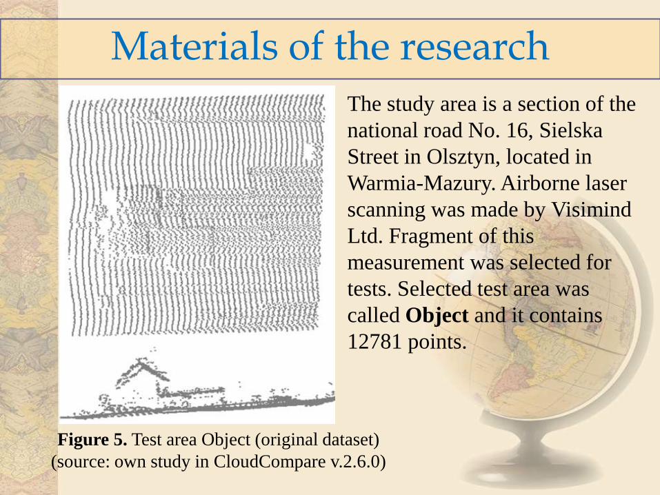
The study area is a section of the
national road No. 16, Sielska
Street in Olsztyn, located in
Warmia-Mazury. Airborne laser
scanning was made by Visimind
Ltd. Fragment of this
measurement was selected for
tests. Selected test area was
called Object and it contains
12781 points.
Materials of the research
Figure 5. Test area Object (original dataset)
(source: own study in CloudCompare v.2.6.0)
Option1: OptD method-filtering
Figure 6. a) dataset after filtration (TSset1)
b) TSset1 after the OptD-multi method application (OptDset1)
The topographic surface dataset for Object was called TSset1.
The number of points in this set is 10414. The application of the
OptD-multi method resulted in obtaining the optimum solution,
which contained OptDset1 with 8121 number of points (22% of
points were removed).
Option2: filtering - OptD-method As a results of the OptD-multi method there is a one set of data
which is called OptDset2. The number of points in this set is
9808. The application of adaptive TIN model selected the dataset
with points which represented the topography: TSset2. The
TSset2 consists of 8005 points.
Figure 7. a) dataset after OptD-multi method application (OptDset2)
b) OptDset2 after filtration (TSset2)
Results
Parameters: Option 1 Option 2
Total number of points in Objects 12781 12781
Number of terrain points in TSset 10414 8005
Number of terrain points in OptDset 8121 9808
DTMs generation
Figure 8. DTMs
a) from all points of TSset1,
b) from points of OptDset1
Figure 9. DTMs
a) from all points of OptDsetD2,
b) from points of TSset2
Based on the analysis, following general conclusions can be
stated:
1. The OptD method is a simple in application method for
data reduction, which takes into account optimization
criteria.
2. The result of the implementation of the OptD method is
an optimal dataset that can be used to generate DTM.
3. The OptD method fulfills all the expectations of
reducing the number of points in dataset without losing
data necessary for the proper DTM generation.
4. Option 1 gives the better solution then option 2.
Conclusions
Thank you for your attention
Contact details: University of Warmia and Mazury
Faculty of Geodesy, Geospatial and Civil Engineering


![Bayes Analysis for Microarrays - Organic Design · 2008. 1. 15. · 3.7 OPTD distribution for the adaptive step-up FDR controlling procedure [28], at α∗ ∈ (0.01,0.05,0.1) levels,](https://static.documents.pub/doc/80x56/60d5777348c21e7a25038b6b/bayes-analysis-for-microarrays-organic-design-2008-1-15-37-optd-distribution.jpg)


