42

ABSTRACT An area master plan, after approval by the District Council and adoption by The Maryland-National Capital Park and Planning Commission, constitutes an amendment to The General Plan (On Wedges and Corridors) for Montgomery County. Each area master plan reflects a vision of future development that responds to the unique character of the local community within the context of a County-wide perspective. Area master plans are intended to convey land use policy for defined geographic areas and should be interpreted together with relevant County-wide functional master plans.
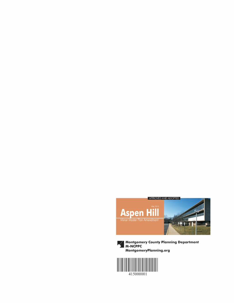
This Minor Master Plan Amendment contains text and supporting maps for a minor amendment to the 1994 Aspen Hill Master Plan. This Plan makes recommendations for land use, zoning, design, transportation, environment, and community facilities. The minor amendment process provides an opportunity to reassess the Subject area and analyze alternative land use redevelopment, design, and zoning opportunities. The review considers existing development and reevaluates the area’s potential within the context of a changing market in the region, the intent and rationale of the 1994 Aspen Hill Master Plan, community input, and impacts to the surrounding land uses and transportation network.
Master and sector plans convey land use policy for defined geographic areas and should be interpreted together with relevant County-wide functional plans and County laws and regulations. Plan recommendations provide comprehensive guidelines for the use of public and private land and should be referred to by public officials and private individuals when making land use decisions. Public and private land use decisions that promote plan goals are essential to fulfilling a plan’s vision.
Master and sector plans look ahead 20 years from the date of adoption, although they are intended to be revised every 10 to 15 years. Moreover, circumstances when a plan is adopted will change and the specifics of a plan may become less relevant over time. Plans do not specify all development possibilities. Their sketches are for illustrative purposes only, intended to convey a sense of desirable future character rather than a recommendation for a particular design.
Master plans do not specify all development possibilities for a particular property or area. In order to understand the full range of development options, the reader should be aware of additional land uses and development potential available through permitted conditional uses; variances; transferrable development rights (TDRs); Moderately Priced Dwelling Units (MPDUs); rezoning by local map amendments; public projects and the mandatory referral process; and municipal annexations.
SOURCE OF COPIES The Maryland-National Capital Park and Planning Commission 8787 Georgia Avenue Silver Spring, MD 20910-3760 Online at: http://www.montgomeryplanning.org/community/aspenhill/
THE MARYLAND-NATIONAL CAPITAL PARK AND PLANNING COMMISSION The Maryland-National Capital Park and Planning Commission is a bi-county agency created by the General Assembly of Maryland in 1927. The Commission’s geographic authority extends to the great majority of Montgomery and Prince George’s Counties; the Maryland-Washington Regional District (M-NCPPC planning jurisdiction) comprises 1,001 square miles, while the Metropolitan District (parks) comprises 919 square miles, in the two counties.
The Commission is charged with preparing, adopting, and amending or extending The General Plan (On Wedges and Corridors) for the Physical Development of the Maryland-Washington Regional District in Montgomery and Prince George’s Counties.
The Commission operates in each county through Planning Boards appointed by the county government. The Boards are responsible for all local plans, zoning amendments, subdivision regulations, and administration of parks.
CERTIFICATION OF APPROVAL AND ADOPTION


1 Aspen Hill Minor Master Plan Amendment Approved and Adopted │ May 2015
CONTENTS
Introduction ..................................................................................................................................................................... 2
Analysis ............................................................................................................................................................................ 9
Land Use and Zoning Recommendations ...................................................................................................................... 11
Design Criteria ................................................................................................................................................................ 13
Transportation ............................................................................................................................................................... 17
Environment .................................................................................................................................................................. 21
Community Facilities .................................................................................................................................................... 22
Implementation ............................................................................................................................................................. 23
Maps
1. Minor Amendment Area .......................................................................................................................................... 2
2. Existing Land Use ..................................................................................................................................................... 3
3. Vicinity Map ............................................................................................................................................................. 5
4. Demographic Study Area - Greater Aspen Hill Neighborhood ............................................................................... 6
5. Minor Amendment Area and Surrounding Land Uses ............................................................................................. 8
6. Existing Zoning ....................................................................................................................................................... 10
7. Proposed Zoning .................................................................................................................................................... 10
8. Area Transit Services .............................................................................................................................................. 18
Tables
1. Aspen Hill and Montgomery County Demographic Comparison Profile ................................................................. 7
Figures
1. Properties North of Aspen Hill Road ...................................................................................................................... 11
2. Properties South of Aspen Hill Road ...................................................................................................................... 12
3. Design Criteria Diagram ......................................................................................................................................... 14
4. Illustration of Potential Long-Term Circulation System ......................................................................................... 16
5. Georgia Avenue Study/Urban Design Framework ................................................................................................. 16
Appendix
A. Demographic Profile
B. Market Analysis
C. Traffic Analysis
2 Aspen Hill Minor Master Plan Amendment Approved and Adopted │ May 2015
INTRODUCTION
Purpose
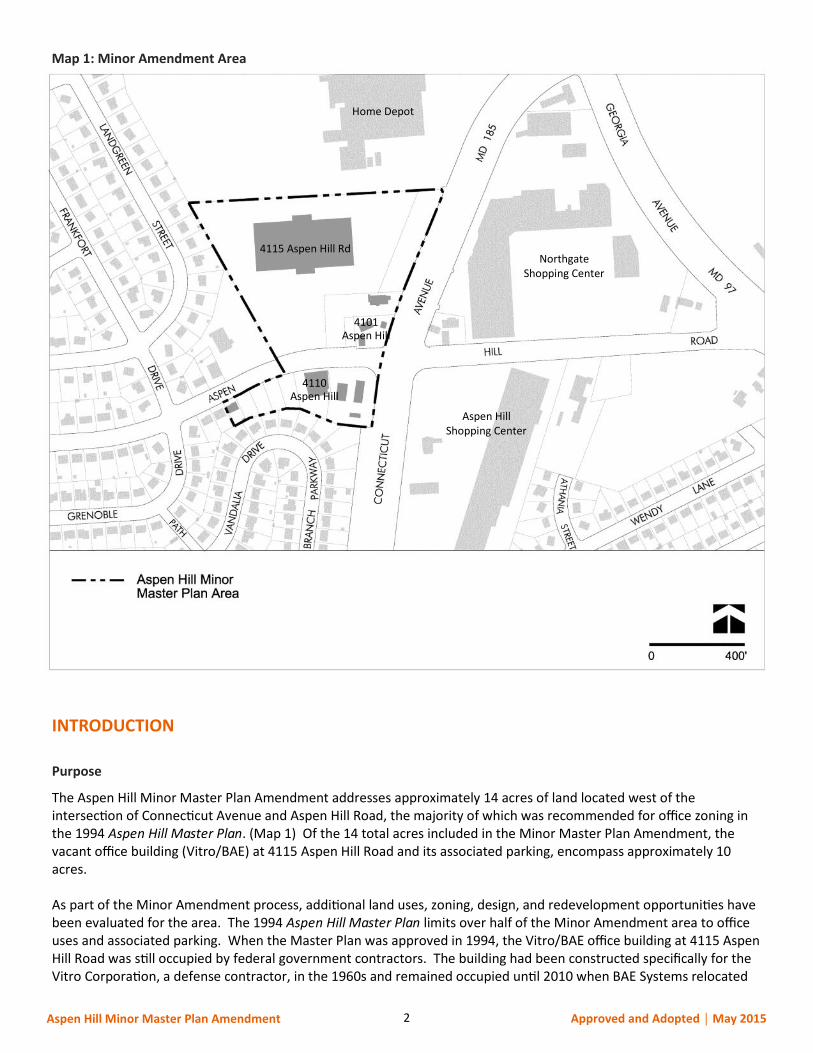
The Aspen Hill Minor Master Plan Amendment addresses approximately 14 acres of land located west of the intersection of Connecticut Avenue and Aspen Hill Road, the majority of which was recommended for office zoning in the 1994 Aspen Hill Master Plan. (Map 1) Of the 14 total acres included in the Minor Master Plan Amendment, the vacant office building (Vitro/BAE) at 4115 Aspen Hill Road and its associated parking, encompass approximately 10 acres. As part of the Minor Amendment process, additional land uses, zoning, design, and redevelopment opportunities have been evaluated for the area. The 1994 Aspen Hill Master Plan limits over half of the Minor Amendment area to office uses and associated parking. When the Master Plan was approved in 1994, the Vitro/BAE office building at 4115 Aspen Hill Road was still occupied by federal government contractors. The building had been constructed specifically for the Vitro Corporation, a defense contractor, in the 1960s and remained occupied until 2010 when BAE Systems relocated
Map 1: Minor Amendment Area
4110 Aspen Hill
4101 Aspen Hill
4115 Aspen Hill Rd
Home Depot
Aspen Hill Shopping Center
Northgate Shopping Center
3 Aspen Hill Minor Master Plan Amendment Approved and Adopted │ May 2015
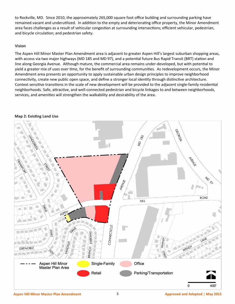
to Rockville, MD. Since 2010, the approximately 265,000 square foot office building and surrounding parking have remained vacant and underutilized. In addition to the empty and deteriorating office property, the Minor Amendment area faces challenges as a result of vehicular congestion at surrounding intersections; efficient vehicular, pedestrian, and bicycle circulation; and pedestrian safety.
Vision
The Aspen Hill Minor Master Plan Amendment area is adjacent to greater Aspen Hill’s largest suburban shopping areas, with access via two major highways (MD 185 and MD 97), and a potential future Bus Rapid Transit (BRT) station and line along Georgia Avenue. Although mature, the commercial area remains under-developed, but with potential to yield a greater mix of uses over time, for the benefit of surrounding communities. As redevelopment occurs, the Minor Amendment area presents an opportunity to apply sustainable urban design principles to improve neighborhood connectivity, create new public open space, and define a stronger local identity through distinctive architecture. Context sensitive transitions in the scale of new development will be provided to the adjacent single-family residential neighborhoods. Safe, attractive, and well-connected pedestrian and bicycle linkages to and between neighborhoods, services, and amenities will strengthen the walkability and desirability of the area.
Map 2: Existing Land Use

4 Aspen Hill Minor Master Plan Amendment Approved and Adopted │ May 2015
Outreach
Outreach efforts included a combination of community meetings, small group and individual meetings, and online and social media platforms to engage the public in the development of the Staff Draft recommendations. Planners met with individual property owners, business owners, and community residents throughout the process. Spanish translation services, both oral and written, were available if needed. A project website (www.montgomeryplanning.org/community/aspenhill) was created with applicable meeting presentations and materials, and an opportunity to leave comments. The Planning Department’s main webpage was used to announce community meetings and interested parties were notified via e-mail. The Plan was also covered by local newspapers, including an editorial in the Washington Post. A project kick-off community meeting was held on December 3, 2013, at the Aspen Hill Public Library to introduce the project and timeline to the community. Aspen Hill area citizen and homeowner associations within two miles of the Minor Amendment area were contacted via email. Interested parties that had contacted the Planning Department about the Project in 2013 prior to its initiation were also notified and added to the e-mail distribution list. Approximately 35 people attended the initial meeting. Two additional community meetings were held on April 1, 2014 and May 13, 2014 with approximately 50 and 70 participants respectively. Each of the community meetings was held at the Aspen Hill Public Library, less than a half mile to the west of the Minor Amendment area. In addition to the community meetings, Staff attended the Aspen Hill Civic Association meeting on April 9, 2014 and the Aspen Hill Homeowners meeting on April 24, 2014 to respond to resident questions and concerns and to promote the final community meeting in May. Both meetings were held at the Aspen Hill Public Library. A robust dialogue was had at each of the community meetings and included a wide range of input from different stakeholder groups, specifically:
The vacant Vitro/BAE office building is a blight on the area and needs to be redeveloped; The land use and zoning should be changed to allow additional retail in the area; There is a need for more reasonably priced commercial goods and grocery in the area; The area is challenging for pedestrians; Traffic in the area, particularly along Aspen Hill Road, is already excessive and large-scale retail would only
make it worse; This area should not be rezoned ahead of the large area, 1994 Aspen Hill Master Plan update; Instead of land use and zoning that allows large-scale commercial uses, could a smaller-scale commercial
land use and zoning classification be considered for the amendment properties at the corners and north side of Aspen Hill Road?
Community meetings, Aspen Hill Public Library
5 Aspen Hill Minor Master Plan Amendment Approved and Adopted │ May 2015
Map 3: Vicinity Map

6 Aspen Hill Minor Master Plan Amendment Approved and Adopted │ May 2015
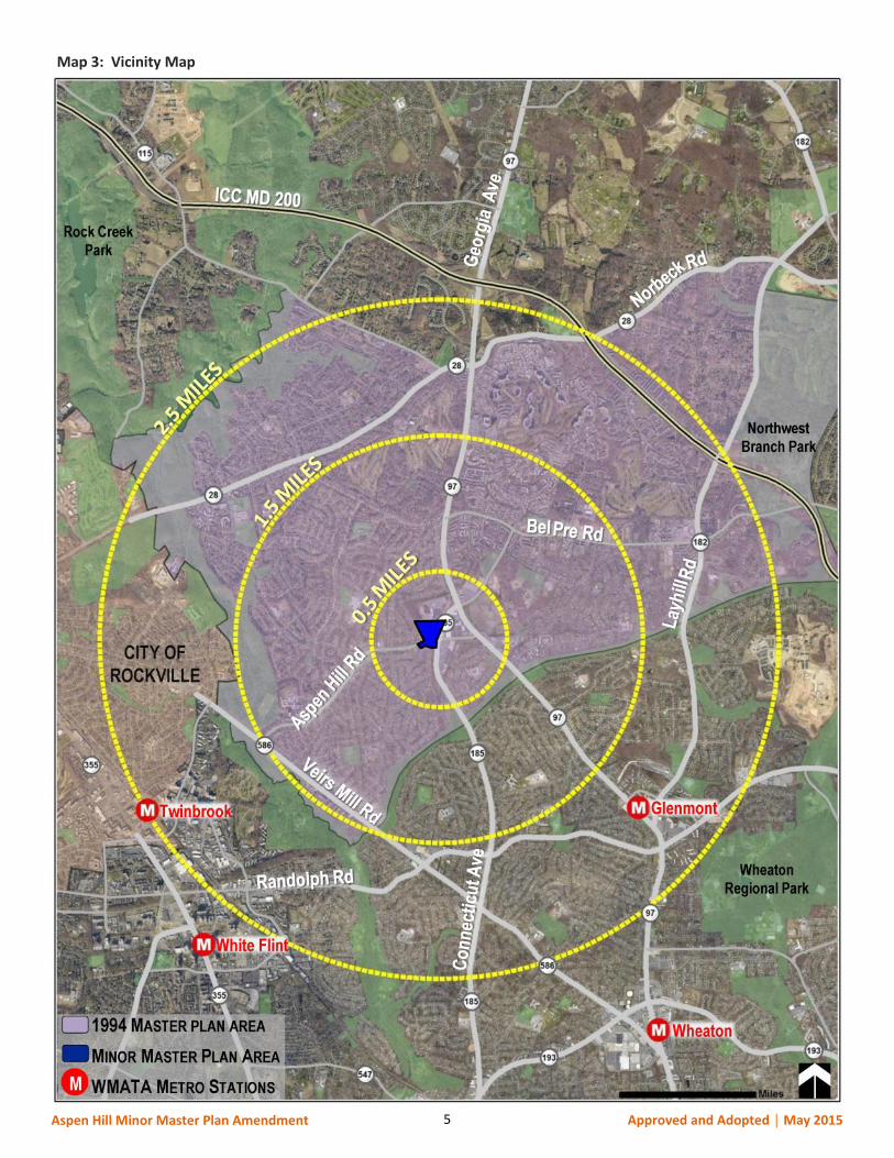
Planning Framework
The Minor Amendment area is located within the approximately 13.2-square mile 1994 Aspen Hill Master Plan boundary (Map 3, previous page), which is situated immediately to the east of the City of Rockville, to the north of the urbanized Wheaton-Glenmont communities, and to the south of Olney. Aspen Hill is considered a Suburban Community as defined by the 1993 General Plan Refinement. The 1994 Aspen Hill Master Plan recommended a change in land uses and zoning, accompanied by design guidelines for much of the Minor Amendment area, located to the west of the Aspen Hill Road and Connecticut Avenue intersection. In 2008, the Planning Board approved a Georgia Avenue Study/Urban Design Framework, which was intended to inform future master plan work for communities along the Georgia Avenue Corridor, including Aspen Hill. This study envisioned an evolution of the commercial node in Aspen Hill from an auto-oriented group of strip shopping centers to a more walkable community with a grid system of streets, a mix of uses, and enhanced pedestrian amenities. In November 2013, the County Council approved the Countywide Transit Corridors Functional Master Plan, which recommends additions to the County’s transportation network. The Plan recommends additional transit facilities along 11 corridors, one of which is North Georgia Avenue, to facilitate Bus Rapid Transit (BRT) service that will move more people to and from jobs, homes, shopping, and entertainment areas in urbanizing parts of the County. The Countywide Transit Corridors Functional Master Plan proposes a future BRT station location at the MD 97 and MD 185 intersection, less than a half-mile from the Minor Amendment area. During this Minor Amendment process, Montgomery County was concurrently in the final stages of completing an extensive process to update the County Zoning maps (zoning conversion) to reflect the Zoning Ordinance text rewrite that was adopted in March 2014. The new zoning classifications adopted by the rewrite became effective October 30, 2014.
Demographics
Research and Special Projects Staff established a baseline profile of the greater Aspen Hill Neighborhood to provide background and context for the Plan’s recommendations. The 2007-2011 American Community Survey 5-year estimate from the United States Census Bureau was utilized for 13 census tracts that match most closely to the greater Aspen Hill boundary. (Map 4 below)
Map 4: Demographic Study Area - Greater Aspen Hill Neighborhood
7 Aspen Hill Minor Master Plan Amendment Approved and Adopted │ May 2015
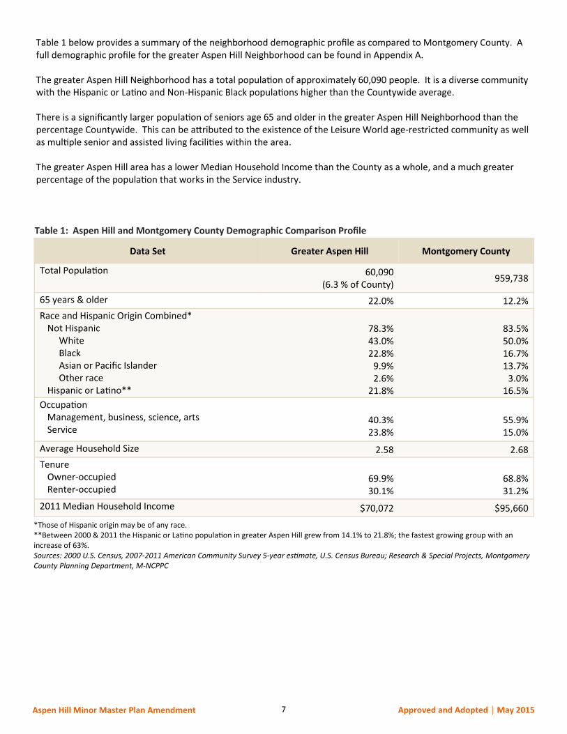
Table 1 below provides a summary of the neighborhood demographic profile as compared to Montgomery County. A full demographic profile for the greater Aspen Hill Neighborhood can be found in Appendix A. The greater Aspen Hill Neighborhood has a total population of approximately 60,090 people. It is a diverse community with the Hispanic or Latino and Non-Hispanic Black populations higher than the Countywide average. There is a significantly larger population of seniors age 65 and older in the greater Aspen Hill Neighborhood than the percentage Countywide. This can be attributed to the existence of the Leisure World age-restricted community as well as multiple senior and assisted living facilities within the area. The greater Aspen Hill area has a lower Median Household Income than the County as a whole, and a much greater percentage of the population that works in the Service industry.
Data Set Greater Aspen Hill Montgomery County
Total Population 60,090 (6.3 % of County)
959,738
65 years & older 22.0% 12.2%
Race and Hispanic Origin Combined* Not Hispanic White Black Asian or Pacific Islander Other race Hispanic or Latino**
78.3% 43.0% 22.8%
9.9% 2.6%
21.8%
83.5% 50.0% 16.7% 13.7%
3.0% 16.5%
Occupation Management, business, science, arts Service
40.3% 23.8%
55.9% 15.0%
Average Household Size 2.58 2.68
Tenure Owner-occupied Renter-occupied
69.9% 30.1%
68.8% 31.2%
2011 Median Household Income $70,072 $95,660
Table 1: Aspen Hill and Montgomery County Demographic Comparison Profile
*Those of Hispanic origin may be of any race. **Between 2000 & 2011 the Hispanic or Latino population in greater Aspen Hill grew from 14.1% to 21.8%; the fastest growing group with an increase of 63%. Sources: 2000 U.S. Census, 2007-2011 American Community Survey 5-year estimate, U.S. Census Bureau; Research & Special Projects, Montgomery County Planning Department, M-NCPPC
8 Aspen Hill Minor Master Plan Amendment Approved and Adopted │ May 2015
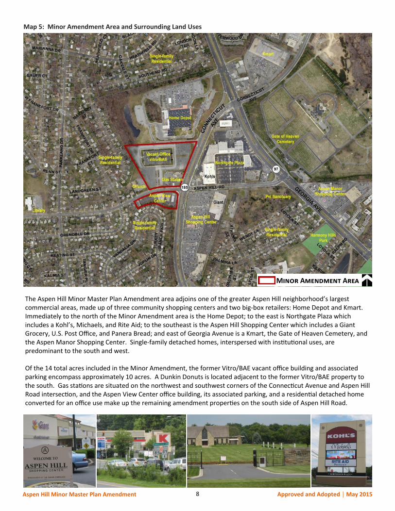
Minor Amendment Area
Map 5: Minor Amendment Area and Surrounding Land Uses
The Aspen Hill Minor Master Plan Amendment area adjoins one of the greater Aspen Hill neighborhood’s largest commercial areas, made up of three community shopping centers and two big-box retailers: Home Depot and Kmart. Immediately to the north of the Minor Amendment area is the Home Depot; to the east is Northgate Plaza which includes a Kohl’s, Michaels, and Rite Aid; to the southeast is the Aspen Hill Shopping Center which includes a Giant Grocery, U.S. Post Office, and Panera Bread; and east of Georgia Avenue is a Kmart, the Gate of Heaven Cemetery, and the Aspen Manor Shopping Center. Single-family detached homes, interspersed with institutional uses, are predominant to the south and west. Of the 14 total acres included in the Minor Amendment, the former Vitro/BAE vacant office building and associated parking encompass approximately 10 acres. A Dunkin Donuts is located adjacent to the former Vitro/BAE property to the south. Gas stations are situated on the northwest and southwest corners of the Connecticut Avenue and Aspen Hill Road intersection, and the Aspen View Center office building, its associated parking, and a residential detached home converted for an office use make up the remaining amendment properties on the south side of Aspen Hill Road.
9 Aspen Hill Minor Master Plan Amendment Approved and Adopted │ May 2015
ANALYSIS
The overall goal of the Plan is to facilitate the enhancement of Aspen Hill as a suburb where people can live, shop, work, and walk to community amenities. Different land use and zoning alternatives, design criteria, and infrastructure improvements were evaluated for the Minor Amendment area, including:
Rezoning the Minor Amendment area to acknowledge the changed office market and to capture the area’s retail market potential, while allowing for a mix of uses, compatible with surrounding land uses, to develop over time.
Establishing design criteria that address future form and function of the Minor Amendment area. Fine-tuning zoning map conversions for properties in the Minor Amendment area to ensure consistency
with Minor Amendment goals. Analyzing and addressing the impacts of added vehicular traffic on Aspen Hill Road and Connecticut
Avenue. Addressing pedestrian safety; connectivity; and vehicular, pedestrian, and bicycle circulation within the
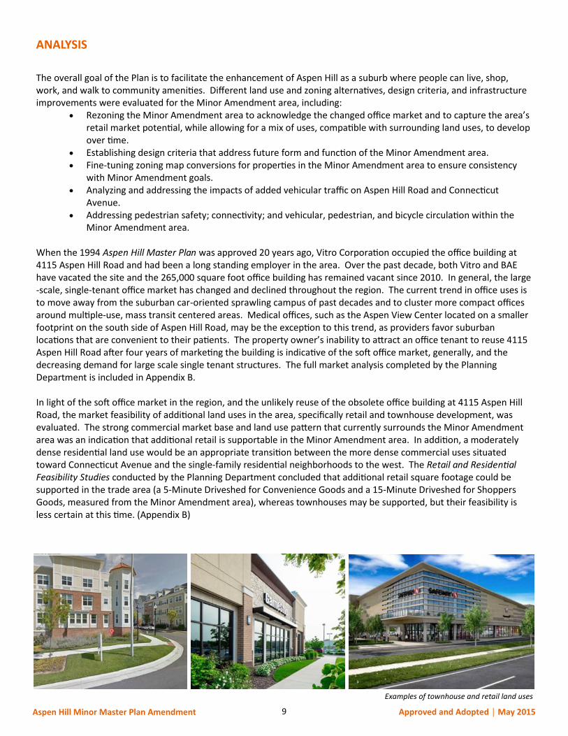
Minor Amendment area. When the 1994 Aspen Hill Master Plan was approved 20 years ago, Vitro Corporation occupied the office building at 4115 Aspen Hill Road and had been a long standing employer in the area. Over the past decade, both Vitro and BAE have vacated the site and the 265,000 square foot office building has remained vacant since 2010. In general, the large-scale, single-tenant office market has changed and declined throughout the region. The current trend in office uses is to move away from the suburban car-oriented sprawling campus of past decades and to cluster more compact offices around multiple-use, mass transit centered areas. Medical offices, such as the Aspen View Center located on a smaller footprint on the south side of Aspen Hill Road, may be the exception to this trend, as providers favor suburban locations that are convenient to their patients. The property owner’s inability to attract an office tenant to reuse 4115 Aspen Hill Road after four years of marketing the building is indicative of the soft office market, generally, and the decreasing demand for large scale single tenant structures. The full market analysis completed by the Planning Department is included in Appendix B. In light of the soft office market in the region, and the unlikely reuse of the obsolete office building at 4115 Aspen Hill Road, the market feasibility of additional land uses in the area, specifically retail and townhouse development, was evaluated. The strong commercial market base and land use pattern that currently surrounds the Minor Amendment area was an indication that additional retail is supportable in the Minor Amendment area. In addition, a moderately dense residential land use would be an appropriate transition between the more dense commercial uses situated toward Connecticut Avenue and the single-family residential neighborhoods to the west. The Retail and Residential Feasibility Studies conducted by the Planning Department concluded that additional retail square footage could be supported in the trade area (a 5-Minute Driveshed for Convenience Goods and a 15-Minute Driveshed for Shoppers Goods, measured from the Minor Amendment area), whereas townhouses may be supported, but their feasibility is less certain at this time. (Appendix B)
Examples of townhouse and retail land uses
10 Aspen Hill Minor Master Plan Amendment Approved and Adopted │ May 2015
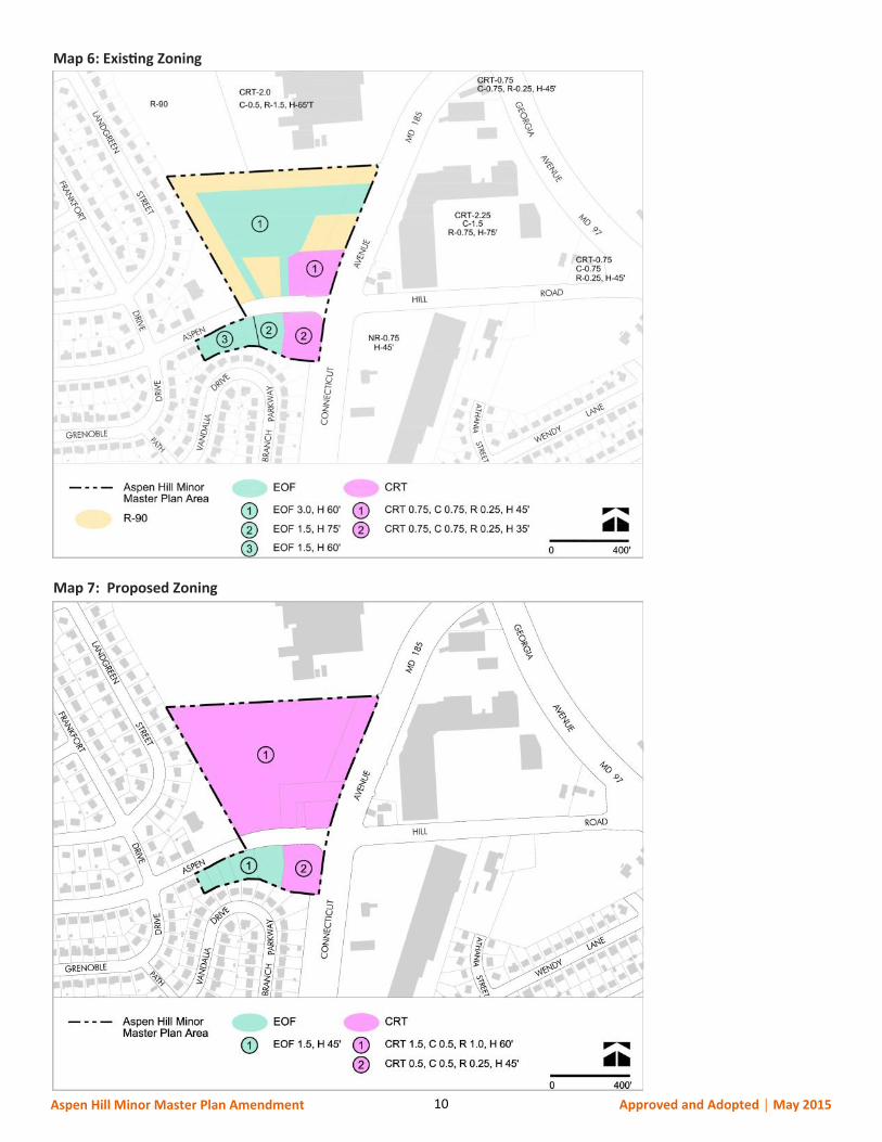
Map 6: Existing Zoning
Map 7: Proposed Zoning
11 Aspen Hill Minor Master Plan Amendment Approved and Adopted │ May 2015
LAND USE AND ZONING RECOMMENDATIONS
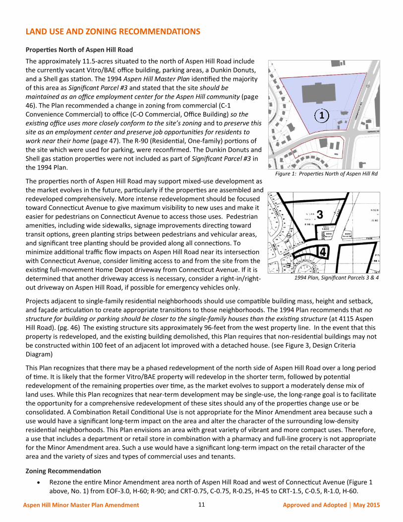
Properties North of Aspen Hill Road
The approximately 11.5-acres situated to the north of Aspen Hill Road include the currently vacant Vitro/BAE office building, parking areas, a Dunkin Donuts, and a Shell gas station. The 1994 Aspen Hill Master Plan identified the majority of this area as Significant Parcel #3 and stated that the site should be maintained as an office employment center for the Aspen Hill community (page 46). The Plan recommended a change in zoning from commercial (C-1 Convenience Commercial) to office (C-O Commercial, Office Building) so the existing office uses more closely conform to the site’s zoning and to preserve this site as an employment center and preserve job opportunities for residents to work near their home (page 47). The R-90 (Residential, One-family) portions of the site which were used for parking, were reconfirmed. The Dunkin Donuts and Shell gas station properties were not included as part of Significant Parcel #3 in the 1994 Plan.
The properties north of Aspen Hill Road may support mixed-use development as the market evolves in the future, particularly if the properties are assembled and redeveloped comprehensively. More intense redevelopment should be focused toward Connecticut Avenue to give maximum visibility to new uses and make it easier for pedestrians on Connecticut Avenue to access those uses. Pedestrian amenities, including wide sidewalks, signage improvements directing toward transit options, green planting strips between pedestrians and vehicular areas, and significant tree planting should be provided along all connections. To minimize additional traffic flow impacts on Aspen Hill Road near its intersection with Connecticut Avenue, consider limiting access to and from the site from the existing full-movement Home Depot driveway from Connecticut Avenue. If it is determined that another driveway access is necessary, consider a right-in/right-out driveway on Aspen Hill Road, if possible for emergency vehicles only.
Projects adjacent to single-family residential neighborhoods should use compatible building mass, height and setback, and façade articulation to create appropriate transitions to those neighborhoods. The 1994 Plan recommends that no structure for building or parking should be closer to the single-family houses than the existing structure (at 4115 Aspen Hill Road). (pg. 46) The existing structure sits approximately 96-feet from the west property line. In the event that this property is redeveloped, and the existing building demolished, this Plan requires that non-residential buildings may not be constructed within 100 feet of an adjacent lot improved with a detached house. (see Figure 3, Design Criteria Diagram)
This Plan recognizes that there may be a phased redevelopment of the north side of Aspen Hill Road over a long period of time. It is likely that the former Vitro/BAE property will redevelop in the shorter term, followed by potential redevelopment of the remaining properties over time, as the market evolves to support a moderately dense mix of land uses. While this Plan recognizes that near-term development may be single-use, the long-range goal is to facilitate the opportunity for a comprehensive redevelopment of these sites should any of the properties change use or be consolidated. A Combination Retail Conditional Use is not appropriate for the Minor Amendment area because such a use would have a significant long-term impact on the area and alter the character of the surrounding low-density residential neighborhoods. This Plan envisions an area with great variety of vibrant and more compact uses. Therefore, a use that includes a department or retail store in combination with a pharmacy and full-line grocery is not appropriate for the Minor Amendment area. Such a use would have a significant long-term impact on the retail character of the area and the variety of sizes and types of commercial uses and tenants.
Zoning Recommendation
Rezone the entire Minor Amendment area north of Aspen Hill Road and west of Connecticut Avenue (Figure 1 above, No. 1) from EOF-3.0, H-60; R-90; and CRT-0.75, C-0.75, R-0.25, H-45 to CRT-1.5, C-0.5, R-1.0, H-60.
1994 Plan, Significant Parcels 3 & 4
Figure 1: Properties North of Aspen Hill Rd
1
12 Aspen Hill Minor Master Plan Amendment Approved and Adopted │ May 2015
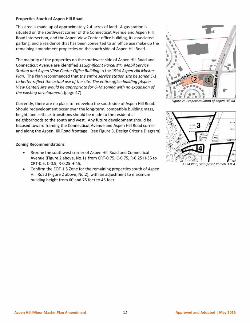
Properties South of Aspen Hill Road
This area is made up of approximately 2.4-acres of land. A gas station is situated on the southwest corner of the Connecticut Avenue and Aspen Hill Road intersection, and the Aspen View Center office building, its associated parking, and a residence that has been converted to an office use make up the remaining amendment properties on the south side of Aspen Hill Road. The majority of the properties on the southwest side of Aspen Hill Road and Connecticut Avenue are identified as Significant Parcel #4: Mobil Service Station and Aspen View Center Office Building in the 1994 Aspen Hill Master Plan. The Plan recommended that the entire service station site be zoned C-1 to better reflect the actual use of the site. The entire office building [Aspen View Center] site would be appropriate for O-M zoning with no expansion of the existing development. (page 47) Currently, there are no plans to redevelop the south side of Aspen Hill Road. Should redevelopment occur over the long-term, compatible building mass, height, and setback transitions should be made to the residential neighborhoods to the south and west. Any future development should be focused toward framing the Connecticut Avenue and Aspen Hill Road corner and along the Aspen Hill Road frontage. (see Figure 3, Design Criteria Diagram)
Zoning Recommendations
Rezone the southwest corner of Aspen Hill Road and Connecticut Avenue (Figure 2 above, No.1) from CRT-0.75, C-0.75, R-0.25 H-35 to CRT-0.5, C-0.5, R-0.25 H-45.
Confirm the EOF-1.5 Zone for the remaining properties south of Aspen Hill Road (Figure 2 above, No.2), with an adjustment to maximum building height from 60 and 75 feet to 45 feet.
1994 Plan, Significant Parcels 3 & 4
Figure 2: Properties South of Aspen Hill Rd
2 1
13 Aspen Hill Minor Master Plan Amendment Approved and Adopted │ May 2015
DESIGN CRITERIA
The commercial center of Aspen Hill is a fragmented, suburban district where most of the land is dedicated to low intensity uses with vast amounts of surface parking. Although mature, the district remains under-developed, but with potential to yield a greater mix of uses over time, for the benefit of surrounding communities. Purpose
As redevelopment occurs, the Minor Amendment area presents an opportunity to apply sustainable urban design principles to improve neighborhood connectivity, create new public open space, and define a local identity through distinctive architecture. Connectivity is a particularly important goal of this Plan. As feasible, there should be internal vehicular and pedestrian connections between properties that will encourage dispersal of movement throughout the Minor Amendment area. More intense redevelopment should be focused toward Connecticut Avenue, with the goal of making new development as accessible to pedestrians as it is to drivers. New development adjacent to single-family residential neighborhoods should use compatible building mass, height, setback, and façade articulation to create appropriate transitions to the residential neighborhoods. Design Guidance
To facilitate the transition of this area to a more pedestrian-friendly, accessible, and human-scale environment, any redevelopment within the Minor Amendment area should incorporate the following design elements.
1. Public Realm Enhancement: Orient building uses to activate pedestrian areas. Along all connections, provide pedestrian amenities, including wide sidewalks, green planting strips between pedestrians and vehicular areas, significant tree planting, street lighting, and street furnishings. Integrate bikeway facilities recommended by the 1994 Aspen Hill Master Plan.
2. Building Placement: All buildings must front on a street (public or private), the shared use drive between Vitro/BAE and Home Depot, or public open space, with a preference for concentrating new development along Connecticut Avenue to establish a street presence along this major thoroughfare and give maximum visibility to new uses.
3. Transition to Residential Neighborhoods: Ensure appropriate transitions between non-residential development and adjacent residential neighborhoods to minimize the impact of new development on those neighborhoods. As required by the Zoning Ordinance, provide landscaping and new tree canopy in parking areas; taper building heights away from existing residential development; and retain (and expand where feasible) existing trees and greenery the entire length of the western edge of the Vitro/BAE property to buffer new development. On the north side of Aspen Hill Road, non-residential buildings may not be constructed within 100 feet of an adjacent lot improved with a detached house.
4. Building Entrances: Provide at least one publicly-accessible entrance on every building façade facing a street or public open space, unless the Planning Board determines that fewer entrances are sufficient to serve the proposed use and still activate the public realm. If two adjoining façades each front on a street or public open space, one entrance at the intersection of these façades may satisfy this requirement for both façades. Any publicly-accessible entrance at a location other than a street or public open space must be accessible via well-designed pedestrian connections to adjacent streets and public open spaces.
5. Façade articulation: Provide architectural elements to articulate façades, create visual interest, and to enhance the community’s identity and character. Articulation strategies may include (but are not limited to) changes in plane, alternative materials, building transparency, incorporation of public art, and incorporation of green elements (e.g. green walls). Building façades may not include blank walls greater than 35 feet in length.
6. Parking and Loading Areas: Surface parking areas must not abut the Connecticut Avenue or Aspen Hill Road rights-of-way and must be set back behind the front building lines of buildings fronting on those rights-of-ways. All parking areas must incorporate significant planting areas and accessible pedestrian walks that connect to enhanced pedestrian areas along the public domain. Loading docks and service areas must not front on or be directly accessible from Connecticut Avenue.
7. Open Space: Consolidate public use space allocated to meet zoning requirements in centralized locations to create substantial urban space for neighborhood use.
14 Aspen Hill Minor Master Plan Amendment Approved and Adopted │ May 2015
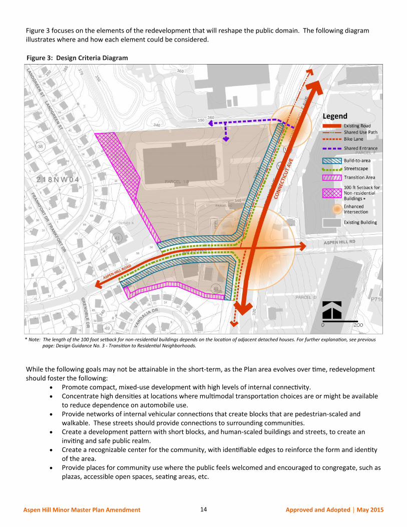
Figure 3 focuses on the elements of the redevelopment that will reshape the public domain. The following diagram illustrates where and how each element could be considered.
While the following goals may not be attainable in the short-term, as the Plan area evolves over time, redevelopment should foster the following:
Promote compact, mixed-use development with high levels of internal connectivity. Concentrate high densities at locations where multimodal transportation choices are or might be available
to reduce dependence on automobile use. Provide networks of internal vehicular connections that create blocks that are pedestrian-scaled and
walkable. These streets should provide connections to surrounding communities. Create a development pattern with short blocks, and human-scaled buildings and streets, to create an
inviting and safe public realm. Create a recognizable center for the community, with identifiable edges to reinforce the form and identity
of the area. Provide places for community use where the public feels welcomed and encouraged to congregate, such as
plazas, accessible open spaces, seating areas, etc.
Figure 3: Design Criteria Diagram
*
* Note: The length of the 100 foot setback for non-residential buildings depends on the location of adjacent detached houses. For further explanation, see previous page: Design Guidance No. 3 - Transition to Residential Neighborhoods.
15 Aspen Hill Minor Master Plan Amendment Approved and Adopted │ May 2015
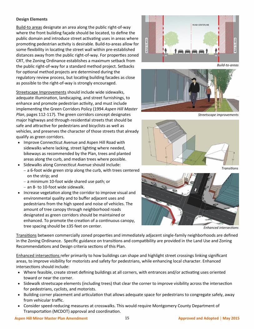
Design Elements
Build-to areas designate an area along the public right-of-way where the front building façade should be located, to define the public domain and introduce street activating uses in areas where promoting pedestrian activity is desirable. Build-to-areas allow for some flexibility in locating the street wall within pre-established distances away from the public right-of-way. For properties zoned CRT, the Zoning Ordinance establishes a maximum setback from the public right-of-way for a standard method project. Setbacks for optional method projects are determined during the regulatory review process, but locating building facades as close as possible to the right-of-way is strongly encouraged.
Streetscape Improvements should include wide sidewalks, adequate illumination, landscaping, and street furnishings, to enhance and promote pedestrian activity, and must include implementing the Green Corridors Policy (1994 Aspen Hill Master Plan, pages 112-117). The green corridors concept designates major highways and through-residential streets that should be safe and attractive for pedestrians and bicyclists as well as vehicles, and preserves the character of those streets that already qualify as green corridors. Improve Connecticut Avenue and Aspen Hill Road with
sidewalks where lacking, street lighting where needed, bikeways as recommended by the Plan, trees and planted areas along the curb, and median trees where possible.
Sidewalks along Connecticut Avenue should include: a 6-foot wide green strip along the curb, with trees centered
on the strip; and a minimum 10-foot wide shared use path; or an 8- to 10-foot wide sidewalk.
Increase vegetation along the corridor to improve visual and environmental quality and to buffer adjacent uses and pedestrians from the high speed and noise of vehicles. The amount of tree canopy through neighborhood roads designated as green corridors should be maintained or enhanced. To promote the creation of a continuous canopy, tree spacing should be ±35 feet on center.
Transitions between commercially zoned properties and immediately adjacent single-family neighborhoods are defined in the Zoning Ordinance. Specific guidance on transitions and compatibility are provided in the Land Use and Zoning Recommendations and Design criteria sections of this Plan.
Enhanced intersections refer primarily to how buildings can shape and highlight street crossings linking significant areas, to improve visibility for motorists and safety for pedestrians, while enhancing local character. Enhanced intersections should include: Where feasible, create street defining buildings at all corners, with entrances and/or activating uses oriented
toward or near the corner. Sidewalk streetscape elements (including trees) that clear the corner to improve visibility across the intersection
for pedestrians, cyclists, and motorists. Building corner placement and articulation that allows adequate space for pedestrians to congregate safely, away
from vehicular traffic. Consider speed-reducing measures at crosswalks. This would require Montgomery County Department of
Transportation (MCDOT) approval and coordination.
Build-to-areas
Streetscape improvements
Transitions
Enhanced intersections
16 Aspen Hill Minor Master Plan Amendment Approved and Adopted │ May 2015
Looking Forward
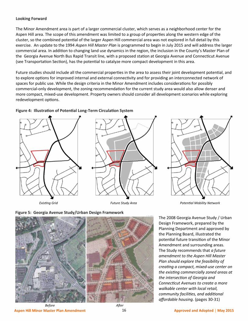
The Minor Amendment area is part of a larger commercial cluster, which serves as a neighborhood center for the Aspen Hill area. The scope of this amendment was limited to a group of properties along the western edge of the cluster, so the combined potential of the larger Aspen Hill commercial area was not explored in full detail by this exercise. An update to the 1994 Aspen Hill Master Plan is programmed to begin in July 2015 and will address the larger commercial area. In addition to changing land use dynamics in the region, the inclusion in the County’s Master Plan of the Georgia Avenue North Bus Rapid Transit line, with a proposed station at Georgia Avenue and Connecticut Avenue (see Transportation Section), has the potential to catalyze more compact development in this area. Future studies should include all the commercial properties in the area to assess their joint development potential, and to explore options for improved internal and external connectivity and for providing an interconnected network of spaces for public use. While the design criteria in the Minor Amendment includes considerations for possibly commercial-only development, the zoning recommendation for the current study area would also allow denser and more compact, mixed-use development. Property owners should consider all development scenarios while exploring redevelopment options. Figure 4: Illustration of Potential Long-Term Circulation System
The 2008 Georgia Avenue Study / Urban Design Framework, prepared by the Planning Department and approved by the Planning Board, illustrated the potential future transition of the Minor Amendment and surrounding areas. The Study recommends that a future amendment to the Aspen Hill Master Plan should explore the feasibility of creating a compact, mixed-use center on the existing commercially zoned areas at the intersection of Georgia and Connecticut Avenues to create a more walkable center with local retail, community facilities, and additional affordable housing. (pages 30-31)
Existing Grid Future Study Area Potential Mobility Network
Figure 5: Georgia Avenue Study/Urban Design Framework
Before After

17 Aspen Hill Minor Master Plan Amendment Approved and Adopted │ May 2015
TRANSPORTATION
The Minor Master Plan Amendment area is located on the western side of Connecticut Avenue (MD 185) along both the northern and southern sides of Aspen Hill Road. The portion located north of Aspen Hill Road, mainly occupied by the former Vitro/BAE vacant office building, is accessed by one full-movement access driveway to Aspen Hill Road, which is presently chained closed, and an internal connection to the Home Depot secondary access driveway to Connecticut Avenue. Connecticut Avenue (MD 185) is a six-lane major highway traversing in a northeast-southwest direction along the eastern frontage of the Minor Amendment area. Traffic signals exist at the nearby intersections with Aspen Hill Road and Georgia Avenue (MD 97). The Home Depot secondary access driveway (immediately north of the Vitro/BAE site) is currently undergoing a traffic signal warrant analysis as a condition of approval for the 30,000-square foot Home Depot expansion. This driveway is located approximately 750 feet north of Aspen Hill Road and approximately 850 feet south of the intersection with Georgia Avenue. The posted speed limit on Connecticut Avenue is 45 MPH. The 2013 annual average daily traffic (AADT) on Connecticut Avenue, as reported by the State Highway Administration (SHA), is approximately 36,300 vehicles per day. This represents a 3.6% decrease from 2011. Georgia Avenue (MD 97) is a six-lane major highway traversing in a northwest-southeast direction approximately a quarter mile east of the properties subject to the Minor Amendment. Traffic signals are in place at the nearby intersections with Aspen Hill Road and Connecticut Avenue. The posted speed limit on Georgia Avenue is 45 MPH. The 2013 AADT on Georgia Avenue, as reported by SHA for the segment near Connecticut Avenue (MD 185), is approximately 43,900 vehicles per day. This represents a 3.8% decrease from 2011. Georgia Avenue is planned as a bus-rapid transit (BRT) corridor with a station to be located at the intersection with Connecticut Avenue. Aspen Hill Road is a two-lane arterial west of Connecticut Avenue and a four-lane arterial east of Connecticut Avenue. It traverses in an east-west direction between the northern and southern portions of the Minor Amendment area. Currently, the full-movement primary site access driveway to the Vitro/BAE site is located on Aspen Hill Road approximately 400 feet west of the intersection with Connecticut Avenue. Traffic signals are in place at the nearby intersections with Connecticut Avenue and Georgia Avenue. In 2008, a traffic calming project was undertaken by Montgomery County Department of Transportation (MCDOT) to install neckdowns and on-street parking which effectively reduced the section of Aspen Hill Road west of Connecticut Avenue from four- to two-lanes. According to MCDOT, between 2008 and 2011, the traffic calming project resulted in a reduction of average vehicular speed from 35 MPH to 34 MPH and the number of collisions over a three-year period reduced from 13 to 4. The posted speed limit on Aspen Hill Road is 30 MPH. The 2013 AADT on Aspen Hill Road, along the site frontage, as reported by SHA, is approximately 17,400 vehicles per day. This represents an increase of 0.2% from 2012.
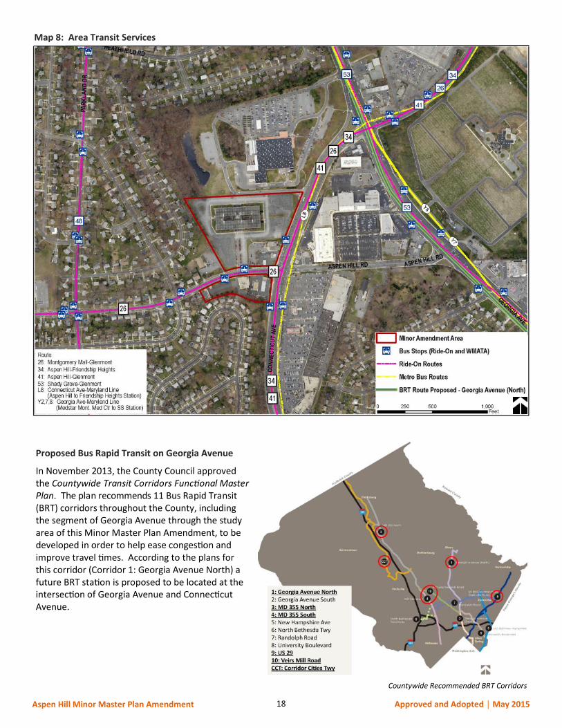
Existing Bus Service
The Minor Amendment area is served by a number of bus routes provided by the County’s Ride On and the Washington Metropolitan Area Transit Authority’s (WMATA) Metrobus services (see Map 8, following page). Along Connecticut Avenue there are a total of four bus routes, three of which are provided by Ride On (#26, #34, #41) and one route (#L8) by Metrobus. Route #26 also runs east-west along Aspen Hill Road. The bus stops along the segment of Georgia Avenue in the vicinity of the Minor Amendment area are served by a total of four bus routes, one Ride-on (#53) and three Metrobus (#Y2, #Y7, #Y8). Depending on time of day, these buses typically run every 20-30 minutes. There are two bus stops on Connecticut Avenue, between Aspen Hill Road and the shared drive between the Vitro/BAE site and the Home Depot, for which the 2011 SHA Pedestrian Road Safety Audit (PRSA) identified relocation to be closer to the intersection with Aspen Hill Road. Based on data collected by MCDOT, Division of Transit Services, more than 300 transit riders are served daily at these two bus stops. Relocation of these bus stops would enhance safety for pedestrians seeking to cross Connecticut Avenue.
18 Aspen Hill Minor Master Plan Amendment Approved and Adopted │ May 2015
Proposed Bus Rapid Transit on Georgia Avenue
In November 2013, the County Council approved the Countywide Transit Corridors Functional Master Plan. The plan recommends 11 Bus Rapid Transit (BRT) corridors throughout the County, including the segment of Georgia Avenue through the study area of this Minor Master Plan Amendment, to be developed in order to help ease congestion and improve travel times. According to the plans for this corridor (Corridor 1: Georgia Avenue North) a future BRT station is proposed to be located at the intersection of Georgia Avenue and Connecticut Avenue.
Map 8: Area Transit Services
Countywide Recommended BRT Corridors
19 Aspen Hill Minor Master Plan Amendment Approved and Adopted │ May 2015
Pedestrian Safety
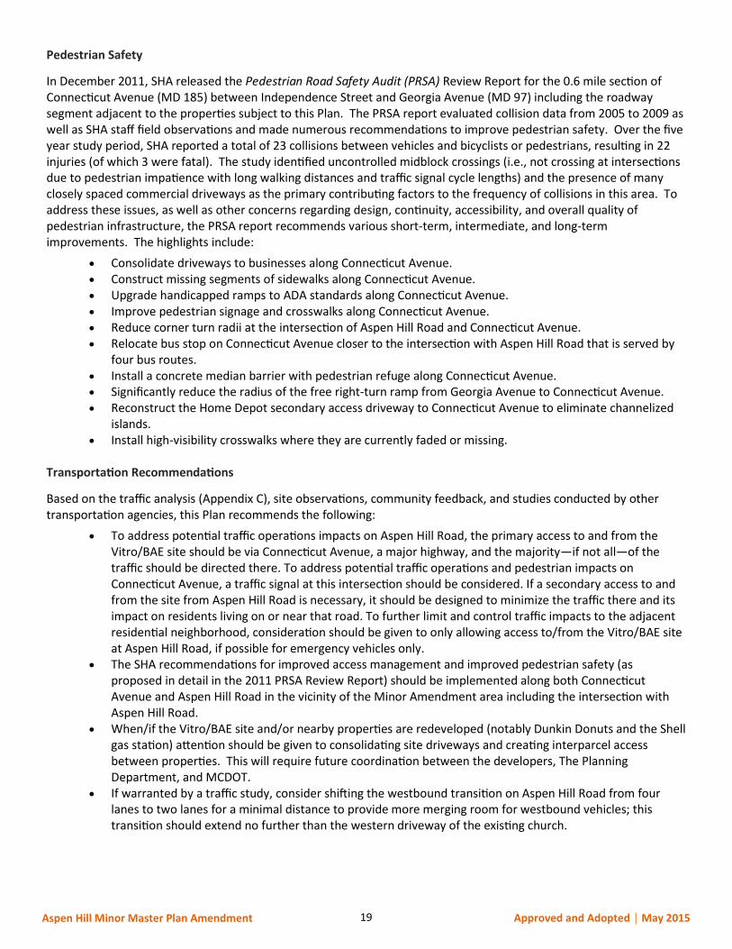
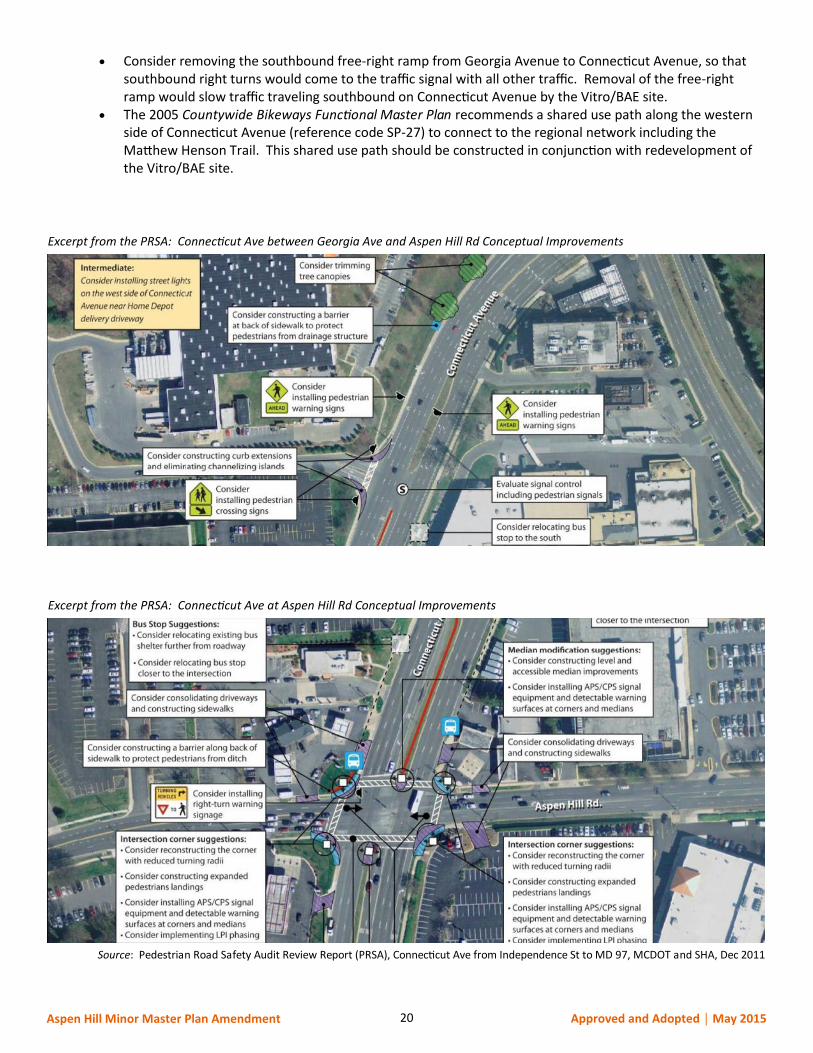
In December 2011, SHA released the Pedestrian Road Safety Audit (PRSA) Review Report for the 0.6 mile section of Connecticut Avenue (MD 185) between Independence Street and Georgia Avenue (MD 97) including the roadway segment adjacent to the properties subject to this Plan. The PRSA report evaluated collision data from 2005 to 2009 as well as SHA staff field observations and made numerous recommendations to improve pedestrian safety. Over the five year study period, SHA reported a total of 23 collisions between vehicles and bicyclists or pedestrians, resulting in 22 injuries (of which 3 were fatal). The study identified uncontrolled midblock crossings (i.e., not crossing at intersections due to pedestrian impatience with long walking distances and traffic signal cycle lengths) and the presence of many closely spaced commercial driveways as the primary contributing factors to the frequency of collisions in this area. To address these issues, as well as other concerns regarding design, continuity, accessibility, and overall quality of pedestrian infrastructure, the PRSA report recommends various short-term, intermediate, and long-term improvements. The highlights include:
Consolidate driveways to businesses along Connecticut Avenue. Construct missing segments of sidewalks along Connecticut Avenue. Upgrade handicapped ramps to ADA standards along Connecticut Avenue. Improve pedestrian signage and crosswalks along Connecticut Avenue. Reduce corner turn radii at the intersection of Aspen Hill Road and Connecticut Avenue. Relocate bus stop on Connecticut Avenue closer to the intersection with Aspen Hill Road that is served by
four bus routes. Install a concrete median barrier with pedestrian refuge along Connecticut Avenue. Significantly reduce the radius of the free right-turn ramp from Georgia Avenue to Connecticut Avenue. Reconstruct the Home Depot secondary access driveway to Connecticut Avenue to eliminate channelized
islands. Install high-visibility crosswalks where they are currently faded or missing.
Transportation Recommendations
Based on the traffic analysis (Appendix C), site observations, community feedback, and studies conducted by other transportation agencies, this Plan recommends the following:
To address potential traffic operations impacts on Aspen Hill Road, the primary access to and from the Vitro/BAE site should be via Connecticut Avenue, a major highway, and the majority—if not all—of the traffic should be directed there. To address potential traffic operations and pedestrian impacts on Connecticut Avenue, a traffic signal at this intersection should be considered. If a secondary access to and from the site from Aspen Hill Road is necessary, it should be designed to minimize the traffic there and its impact on residents living on or near that road. To further limit and control traffic impacts to the adjacent residential neighborhood, consideration should be given to only allowing access to/from the Vitro/BAE site at Aspen Hill Road, if possible for emergency vehicles only.
The SHA recommendations for improved access management and improved pedestrian safety (as proposed in detail in the 2011 PRSA Review Report) should be implemented along both Connecticut Avenue and Aspen Hill Road in the vicinity of the Minor Amendment area including the intersection with Aspen Hill Road.
When/if the Vitro/BAE site and/or nearby properties are redeveloped (notably Dunkin Donuts and the Shell gas station) attention should be given to consolidating site driveways and creating interparcel access between properties. This will require future coordination between the developers, The Planning Department, and MCDOT.
If warranted by a traffic study, consider shifting the westbound transition on Aspen Hill Road from four lanes to two lanes for a minimal distance to provide more merging room for westbound vehicles; this transition should extend no further than the western driveway of the existing church.
20 Aspen Hill Minor Master Plan Amendment Approved and Adopted │ May 2015
Consider removing the southbound free-right ramp from Georgia Avenue to Connecticut Avenue, so that southbound right turns would come to the traffic signal with all other traffic. Removal of the free-right ramp would slow traffic traveling southbound on Connecticut Avenue by the Vitro/BAE site.
The 2005 Countywide Bikeways Functional Master Plan recommends a shared use path along the western side of Connecticut Avenue (reference code SP-27) to connect to the regional network including the Matthew Henson Trail. This shared use path should be constructed in conjunction with redevelopment of the Vitro/BAE site.
Excerpt from the PRSA: Connecticut Ave between Georgia Ave and Aspen Hill Rd Conceptual Improvements
Excerpt from the PRSA: Connecticut Ave at Aspen Hill Rd Conceptual Improvements
Source: Pedestrian Road Safety Audit Review Report (PRSA), Connecticut Ave from Independence St to MD 97, MCDOT and SHA, Dec 2011
21 Aspen Hill Minor Master Plan Amendment Approved and Adopted │ May 2015
ENVIRONMENT
The 1994 Aspen Hill Master Plan area is located in the Turkey Branch subwatershed of the Rock Creek watershed. The area is highly urbanized and completely developed with auto-centric uses. Most of the development occurred at a time before stormwater management regulations were in place. There are almost no natural resources or environmental functions remaining and there are no sensitive areas to protect.
This Plan envisions more sustainable development within the footprint of the existing development. Incorporating new development into the existing developed area will reduce land consumption and vehicle miles travelled, improve our carbon footprint, and water and air quality. While the Minor Amendment area is currently more than 90% impervious with very little stormwater management or tree canopy, redevelopment provides the opportunity to improve environmental conditions and create a greener community.
Recommendations focus on increasing the livability of the community while optimizing the land use within the existing development footprint. Implementation will occur through the redevelopment process. Carbon Footprint Analysis
Montgomery County Bill number 32-07 establishes a goal to stop increasing greenhouse gas emissions by the year 2010, and to reduce emissions to 20 percent of 2005 levels by the year 2050. There are three main components to greenhouse gas emissions: embodied emissions, building energy emissions, and transportation emissions. Embodied emissions are emissions that are created through the extraction, processing, transportation, construction and disposal of building materials as well as emissions created through landscape disturbance (by both soil disturbance and changes in above ground biomass). Building energy emissions are created in the normal operation of a building including lighting, heating cooling and ventilation, operation of computers and appliances, etc. Transportation emissions are released by the operation of cars, trucks, buses, motorcycles, etc.
While it is not possible to quantify the carbon footprint of this Plan due to the small geographic area, it is possible to qualitatively analyze the impacts of the recommended land uses on the County’s carbon footprint. The embodied emissions contribution to total greenhouse gas emissions will increase, due to the demolition of existing structures and construction of new structures. Newly developed buildings have decreased energy emissions due to substantial advances in energy efficiency. Total transportation emissions will increase because the majority of the Minor Amendment area is currently occupied by a vacant building. Mixed use development would typically have a lower carbon footprint than redevelopment under the current zoning due to the reduction of single-function automobile trips. Recommendations
Increase tree canopy cover by: Using advanced planting techniques such as constructed soil and interconnected tree pits to increase the
soil area for tree roots for new streets and sidewalks. As feasible, satisfy Forest Conservation requirements on the Vitro/BAE site through the use of canopy
credit, in order to increase tree cover in the planning area. Establishing a minimum of 30% tree canopy cover for new surface parking.
Minimize and mitigate for impervious surfaces by: Using Environmental Site Design to reduce runoff from all impervious surfaces, including roofs, terraces,
and paving.
Reduce energy consumption by: Promoting non-auto transportation by providing for pedestrian and bicycle linkages and incorporating
transit stops within new development.
22 Aspen Hill Minor Master Plan Amendment Approved and Adopted │ May 2015
COMMUNITY FACILITIES
The Minor Amendment area is well served by nearby schools, parks, recreation areas, and libraries. Brookhaven Elementary School and Parkland Magnet Middle School are located within a mile of the Minor Amendment area. The Aspen Hill Public Library, situated on Aspen Hill Road, is less than a half mile from the intersection of Connecticut Ave and Aspen Hill Road, and the Wheaton Woods Swimming Pool is a short walk to the west beyond the Library. According to Montgomery County Public Schools, the elementary and middle schools that serve the Minor Amendment area are projected to be within capacity for the next six years. At the high school level the area is served by the Downcounty High Schools Consortium - Blair, Einstein, Kennedy, Northwood, and Wheaton. Blair, Einstein, and Northwood high schools are projected to exceed their capacities in the coming years. Given the smaller geographic scope of this Plan and the limited emphasis on new, near-term residential redevelopment, this Minor Master Plan Amendment would have limited to no impact on school capacity. As part of the overall update to the 1994 Aspen Hill Master Plan, school capacity and the need for any future capital programs will be evaluated in greater detail. Several nearby parks serve this area of the Aspen Hill community, including English Manor Neighborhood Park, Parkland Local Park, Aquarius Local Park, Northgate Local Park, Strathmore Local Park, Aspen Hill Local Park, and Harmony Hills Neighborhood Park. The Matthew Henson State Park and Trail is within a mile of the Minor Amendment area and Rock Creek Park and Trail is within approximately one and a half miles. The 2012 Parks, Recreation and Open Space (PROS) Plan does not identify needs for additional parkland in this area of the County; it only specifies 2 additional tennis courts. As properties redevelop within the boundaries of this Minor Amendment, the new development will be required to provide public amenity space as well as meet the recreation guidelines to help offset the needs of any new residents. As recommended in the Transportation section (page 25), this Plan supports connections that serve as vital links to the regional network and Countywide trail corridors. This Plan affirms the recommendation in the 2005 Countywide Bikeways Functional Master Plan to install a shared use path along the western side of Connecticut Avenue (reference code SP-27) to connect to the regional network, including the Matthew Henson Trail. This shared use path should be constructed in conjunction with applicable redevelopment in the Minor Amendment area.
23 Aspen Hill Minor Master Plan Amendment Approved and Adopted │ May 2015
IMPLEMENTATION
This section outlines those steps necessary to implement the zoning recommendations of this Amendment. After the adoption of this Plan, the Zoning recommendations will be implemented through a Sectional Map Amendment.
Proposed Zoning Text Amendment
The CRT zone incorporates a series of prescriptive form and placement standards as a means to accomplishing the intent of the zone. Flexibility is currently built into the Zoning Code by allowing a developer to choose to develop under the Optional Method of development. By doing so, development standards are established by the site plan approval process and are therefore instituted through Planning Board review. Even with this option, however, through ongoing outreach and training sessions on the new Zoning Code, concern continues regarding certain development standards. In response, an alternative to the approval process under Standard Method Development should be considered to allow additional flexibility through the site plan approval process.
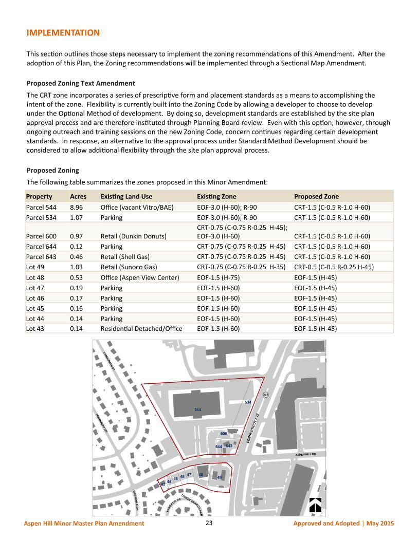
Proposed Zoning
The following table summarizes the zones proposed in this Minor Amendment:
Property Acres Existing Land Use Existing Zone Proposed Zone
Parcel 544 8.96 Office (vacant Vitro/BAE) EOF-3.0 (H-60); R-90 CRT-1.5 (C-0.5 R-1.0 H-60)
Parcel 534 1.07 Parking EOF-3.0 (H-60); R-90 CRT-1.5 (C-0.5 R-1.0 H-60)
Parcel 600 0.97 Retail (Dunkin Donuts) CRT-0.75 (C-0.75 R-0.25 H-45); EOF-3.0 (H-60) CRT-1.5 (C-0.5 R-1.0 H-60)
Parcel 644 0.12 Parking CRT-0.75 (C-0.75 R-0.25 H-45) CRT-1.5 (C-0.5 R-1.0 H-60)
Parcel 643 0.46 Retail (Shell Gas) CRT-0.75 (C-0.75 R-0.25 H-45) CRT-1.5 (C-0.5 R-1.0 H-60)
Lot 49 1.03 Retail (Sunoco Gas) CRT-0.75 (C-0.75 R-0.25 H-35) CRT-0.5 (C-0.5 R-0.25 H-45)
Lot 48 0.53 Office (Aspen View Center) EOF-1.5 (H-75) EOF-1.5 (H-45)
Lot 47 0.19 Parking EOF-1.5 (H-60) EOF-1.5 (H-45)
Lot 46 0.17 Parking EOF-1.5 (H-60) EOF-1.5 (H-45)
Lot 45 0.16 Parking EOF-1.5 (H-60) EOF-1.5 (H-45)
Lot 44 0.14 Parking EOF-1.5 (H-60) EOF-1.5 (H-45)
Lot 43 0.14 Residential Detached/Office EOF-1.5 (H-60) EOF-1.5 (H-45)
24 Aspen Hill Minor Master Plan Amendment Approved and Adopted │ May 2015

25 Aspen Hill Minor Master Plan Amendment Approved and Adopted │ May 2015
26 Aspen Hill Minor Master Plan Amendment Approved and Adopted │ May 2015
27 Aspen Hill Minor Master Plan Amendment Approved and Adopted │ May 2015
28 Aspen Hill Minor Master Plan Amendment Approved and Adopted │ May 2015

29 Aspen Hill Minor Master Plan Amendment Approved and Adopted │ May 2015
30 Aspen Hill Minor Master Plan Amendment Approved and Adopted │ May 2015

31 Aspen Hill Minor Master Plan Amendment Approved and Adopted │ May 2015

32 Aspen Hill Minor Master Plan Amendment Approved and Adopted │ May 2015
This Page Intentionally Left Blank
33 Aspen Hill Minor Master Plan Amendment Approved and Adopted │ May 2015
ELECTED AND APPOINTED OFFICIALS
County Council
George Leventhal, President
Sidney Katz
Roger Berliner
Tom Hucker
Marc Elrich
Nancy Floreen
Nancy Navarro
Craig Rice
Hans Riemer
County Executive
Isiah Leggett
The Maryland-National Capital Park and Planning Commission
Elizabeth M. Hewlett, Chair
Casey Anderson, Vice Chair
Commissioners
Montgomery County Planning Board Prince George’s County Planning Board
Casey Anderson, Chair Elizabeth M. Hewlett, Chair
Marye Wells-Harley, Vice Chair Dorothy F. Bailey, Vice Chair
Norman Dreyfuss Manuel R. Geraldo
Natali Fani-Gonzalez John P. Shoaff
Amy Presley A. Shuanise Washington

34 Aspen Hill Minor Master Plan Amendment Approved and Adopted │ May 2015
THE PLAN PROCESS
A plan provides comprehensive recommendations for the use of publicly and privately owned land. Each plan reflects a
vision of the future that responds to the unique character of the local community within the context of a countywide
perspective.
Together with relevant policies, plans should be referred to by public officials and private individuals when making land
use decisions.
The STAFF DRAFT PLAN is prepared by the Montgomery County Planning Department for presentation to the
Montgomery County Planning Board. The Planning Board reviews the Staff Draft Plan, makes preliminary changes as
appropriate, and approves the Plan for public hearing. After the Planning Board’s changes are made, the document
becomes the Public Hearing Draft Plan.
The PUBLIC HEARING DRAFT PLAN is the formal proposal to amend an adopted master plan or sector plan. Its
recommendations are not necessarily those of the Planning Board; it is prepared for the purpose of receiving public
testimony. The Planning Board holds a public hearing and receives testimony, after which it holds public worksessions
to review the testimony and revise the Public Hearing Draft Plan as appropriate. When the Planning Board’s changes
are made, the document becomes the Planning Board Draft Plan.
The PLANNING BOARD DRAFT PLAN is the Board's recommended Plan and reflects their revisions to the Public Hearing
Draft Plan. The Regional District Act requires the Planning Board to transmit a sector plan to the County Council with
copies to the County Executive who must, within sixty days, prepare and transmit a fiscal impact analysis of the
Planning Board Draft Plan to the County Council. The County Executive may also forward to the County Council other
comments and recommendations.
After receiving the Executive's fiscal impact analysis and comments, the County Council holds a public hearing to
receive public testimony. After the hearing record is closed, the relevant Council committee holds public worksessions
to review the testimony and makes recommendations to the County Council. The Council holds its own worksessions,
then adopts a resolution approving the Planning Board Draft Plan, as revised.
After Council approval the plan is forwarded to the Maryland-National Capital Park and Planning Commission for
adoption. Once adopted by the Commission, the plan officially amends the master plans, functional plans, and sector
plans cited in the Commission's adoption resolution.
35 Aspen Hill Minor Master Plan Amendment Approved and Adopted │ May 2015
ACKNOWLEDGEMENTS
Gwen Wright, Director
Rose Krasnow, Deputy Director
Project Team
Area 2 Division
Glenn Kreger, Chief
Nancy Sturgeon, Master Planner Supervisor
Andrea Gilles (Lead Planner)
Luis Estrada Cepero, Urban Design
Amy Lindsey, Environment
Ed Axler, Transportation
Aaron Zimmerman, Transportation
Research and Special Projects Division
Valdis Lazdins, Chief
Richard Liu
Lisa Tate
Pam Zorich
Park Planning, Department of Parks
Brooke Farquhar
Charles Kines
Management Services
Bridget Schwiesow, Communications Manager
Kevin Leonard
Legal
Carol Rubin, Associate General Counsel
Nicholas Dumais, Associate General Counsel

36 Aspen Hill Minor Master Plan Amendment Approved and Adopted │ May 2015
![Untitled-8 []...Title: Untitled-8 Created Date: 20181121103711Z](https://static.documents.pub/doc/80x56/5f535b10acd546526243f6d6/-untitled-8-title-untitled-8-created-date-20181121103711z.jpg)
![Untitled-8 [interket.co.uk] · Title: Untitled-8 Created Date: 20190111130116Z](https://static.documents.pub/doc/80x56/5f535d8fe9ce7627b31125e1/untitled-8-title-untitled-8-created-date-20190111130116z.jpg)
![Untitled-1 [] · Title: Untitled-1 Created Date: 20110827203248Z](https://static.documents.pub/doc/80x56/5e5c37ba4f4d7a6137230a3c/untitled-1-title-untitled-1-created-date-20110827203248z.jpg)
![Untitled-2 [] · Untitled-2 Author: Carsten Roggon Subject: Untitled-2 Keywords: Untitled-2 Created Date: 20110220145933 ...](https://static.documents.pub/doc/80x56/605a049a597af41a6973e7e0/untitled-2-untitled-2-author-carsten-roggon-subject-untitled-2-keywords-untitled-2.jpg)
![(UNTITLED) []...Title (UNTITLED) Subject (UNTITLED)](https://static.documents.pub/doc/80x56/5e75d9c1b01cbe739756294f/-untitled-title-untitled-subject-untitled.jpg)
![(UNTITLED) [ ] · PDF fileTitle (UNTITLED) Subject (UNTITLED) Keywords](https://static.documents.pub/doc/80x56/5a7ca10e7f8b9ae9398d019f/untitled-untitled-subject-untitled-keywords.jpg)
![Untitled-1 []€¦ · Potenzfunktionen mit negativen Exponenten Untitled-1.nb . 4 Untitled-1.nb. Untitled-1.nb 5](https://static.documents.pub/doc/80x56/605b197ad57d6d08187081fc/untitled-1-potenzfunktionen-mit-negativen-exponenten-untitled-1nb-4-untitled-1nb.jpg)
![Untitled-5 [unstats.un.org]...Title Untitled-5 Created Date 20010118111809Z](https://static.documents.pub/doc/80x56/60389b95586a40652f159b99/-untitled-5-title-untitled-5-created-date-20010118111809z.jpg)
![Untitled-2 [about.gitlab.com] · Title: Untitled-2 Created Date: 20161031172420Z](https://static.documents.pub/doc/80x56/5aecde047f8b9a66258f266b/untitled-2-about-untitled-2-created-date-20161031172420z.jpg)
![Untitled document [] · 2017. 6. 11. · Untitled document](https://static.documents.pub/doc/80x56/60b5fa1afeb575185d5dfee6/untitled-document-2017-6-11-untitled-document.jpg)
![Untitled-3 [] · Title: Untitled-3 Created Date: 20190220150220Z](https://static.documents.pub/doc/80x56/5f02c5e47e708231d405f06a/untitled-3-title-untitled-3-created-date-20190220150220z.jpg)
![Untitled-3 []Title: Untitled-3 Created Date: 20050330105657Z](https://static.documents.pub/doc/80x56/60347471aeac2f25265309a6/-untitled-3-title-untitled-3-created-date-20050330105657z.jpg)
![(UNTITLED) []...Title (UNTITLED) Subject (UNTITLED) Keywords](https://static.documents.pub/doc/80x56/5e9b61cb57896228d3155fa7/-untitled-title-untitled-subject-untitled-keywords.jpg)
![Untitled-3 [didcotrailwaycentre.org.uk] · Title: Untitled-3.jpg Created Date: 20181215120305Z](https://static.documents.pub/doc/80x56/5fea7b7def8fd4598c36c93a/untitled-3-title-untitled-3jpg-created-date-20181215120305z.jpg)
![Untitled-1 [] · Untitled-1 Subject: Untitled-1 Keywords: Untitled-1 Created Date: 20110513150011 ...](https://static.documents.pub/doc/80x56/60436b02647e0d00c02c5ab3/untitled-1-untitled-1-subject-untitled-1-keywords-untitled-1-created-date.jpg)
![Untitled-6 []...Untitled-6 Author: turtle Subject: Untitled-6 Created Date: 3/5/2003 8:41:27 PM ...](https://static.documents.pub/doc/80x56/602bf9e5400fe51bf2284894/untitled-6-untitled-6-author-turtle-subject-untitled-6-created-date-352003.jpg)

![Untitled Document [docs.oracle.com] · Title: Untitled Document Created Date: 191000801172643](https://static.documents.pub/doc/80x56/603a60be0019ab59b214b59a/untitled-document-docs-title-untitled-document-created-date-191000801172643.jpg)