Stephen F. Greb, David C. Harris, Thomas M. (Marty) Parris, Cortland F. Eble, and Brandon C. Nuttall Kentucky Geological Survey, University of Kentucky Update on the Berea Sandstone Oil Play in Kentucky
Transcript
Stephen F. Greb, David C. Harris, Thomas M. (Marty) Parris, Cortland F. Eble, and
Brandon C. Nuttall
Kentucky Geological Survey, University of Kentucky
Update on the Berea Sandstone Oil Play
in Kentucky
Update on the Berea Ss
Berea Ss background Recent KY oil production
trends Greenup and Lawrence
County update Research questions
raised by recent activity Berea Sandstone
Consortium
The Berea Ss is an upper Devonian “tight sand” (siltstone across much of KY)
Interfingers with the Bedford Sh
Overlain by the Sunbury Sh and underlain by the Ohio Sh (potential source rocks)
Background
Berea outcrops in NE KY
Background
1 cm
1 cm1 cm
Background
Based on existing models (e.g., Pashin and Ettensohn, 1995), Ky reservoirs could be developed in storm shelf and slope facies including turbidite fans and channels.
Berea
(from Pashin and Ettensohn, 1995)
CLEVELAND SHALE
HURON SHALE
THREE LICK BED
HURON SHALE Basement-related growth fault
Basin floor Turbidite fans/ aprons Feeder channel
Storm-dominated shelf
Eastern KY type Log, Lawrence County
137383APP ENERGY 1 MOORE, C
LawrenceKY
0 400Gamma Ray
7 17Caliper
2 3Bulk Density
0 10PEF
30 -10Density Por (ss)
67 77TEMP
30 -10NPHI%
0.2 200RILD
0.2 200RILM
Sunbury ShBerea Ss/Bedford Sh
Ohio Sh
1200
1300
Lawrencett
APP ENERG Y 1 M O O RE, C
FEET
0 66,611
PETRA 4/22/2013 1:42:32 PM
Background
Berea is a classic low-permeability
reservoir (perms are generally less than 2 md based
on available core)
Berea Hydrocarbon Distribution Oil production
limited to NE KY Shallower part of
basin (north of Rome Trough)
1,898 Berea completions (mostly verticals) in KGS database
KEN
MASONGREENUP
LEWISRTSON
FLEMING
BOYD
CARTERICHOLAS
ROWAN
BATH
LAWRENCE
ELLIOTT
MONTGOMERY
MORGANMENIFEE
JOHNSONMARTIN
POWELL
MAGOFFIN
WOLFE
ESTILL
FLOYD
PIKE
LEE
BREATHITT
JACKSON OWSLEY
KNOTT
PERRY
CLAYREL
LESLIELETCHER
KNOXHARLAN
LEY BELL
BEREA PRODUCTION - BEREA PRODUCTION
FEET
0 112,382
PETRA 4/22/2013 5:02:40 PM
Oil, Oil & Gas
Gas
IPCFS
KRFS
Boyd
Background
Greenup
Lawrence
Johnson
58 horizontal oil completions since 2011
Berea Production
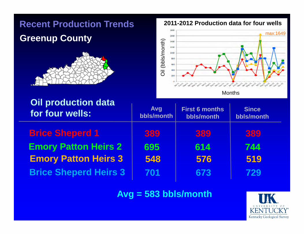
Recent Production TrendsGreenup County
True vertical depths: 979-1362 ft (avg = 1132 ft)
Stratigraphic traps
Average lateral is 2,500 ft, oriented SE-NW (downdip)
Multistage hydraulic fracture stimulation
Operator: Nytis Exploration First completion in March, 2011 51 horizontal wells permitted Completion data submitted for 28 wells
Recent Production TrendsGreenup County
17 wells with IP’s as of March, 2014
Reported oil IP’s: 12-70 BOPD 7-37 MCFGD
Water IP: 15-114 bbl/day
WOR (water/oil): 1.3-6.0 (avg = 3)
Greenup
Boyd
Carter
Greenup
Boyd
Greenup County Horizontal Well Locations 2014
Recent Oil Production Trends
2011-2012 Production data for four wells
Months
Oil
(bbl
s/m
onth
)
Oil production data for four wells:
Brice Sheperd 1Emory Patton Heirs 2
Avgbbls/month
First 6 months bbls/month
Since bbls/month
389695
389614
389744
Emory Patton Heirs 3Brice Sheperd Heirs 3
548701
576673
519729
max:1649
Avg = 583 bbls/month
Recent Production TrendsGreenup County
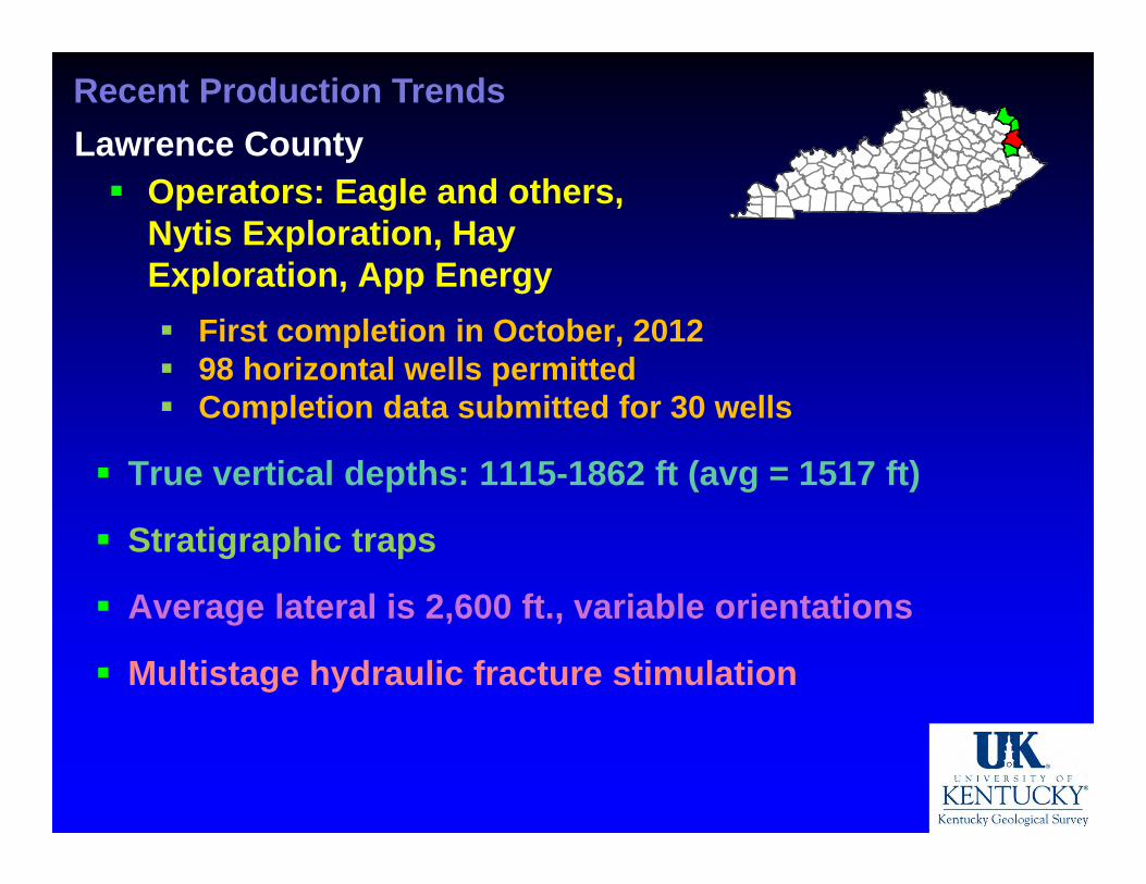
True vertical depths: 1115-1862 ft (avg = 1517 ft)
Stratigraphic traps
Average lateral is 2,600 ft., variable orientations
Multistage hydraulic fracture stimulation
Recent Production TrendsLawrence County Operators: Eagle and others,
Nytis Exploration, Hay Exploration, App Energy First completion in October, 2012 98 horizontal wells permitted Completion data submitted for 30 wells
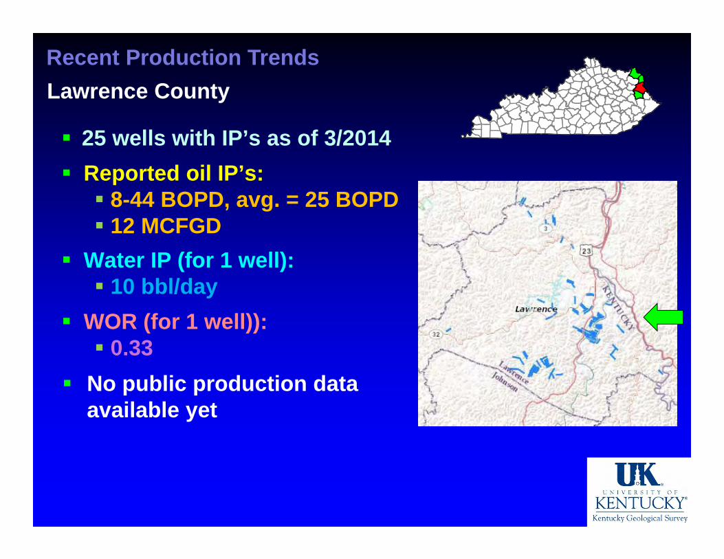
Recent Production TrendsLawrence County
25 wells with IP’s as of 3/2014 Reported oil IP’s: 8-44 BOPD, avg. = 25 BOPD 12 MCFGD
Water IP (for 1 well): 10 bbl/day
WOR (for 1 well)): 0.33
No public production data available yet
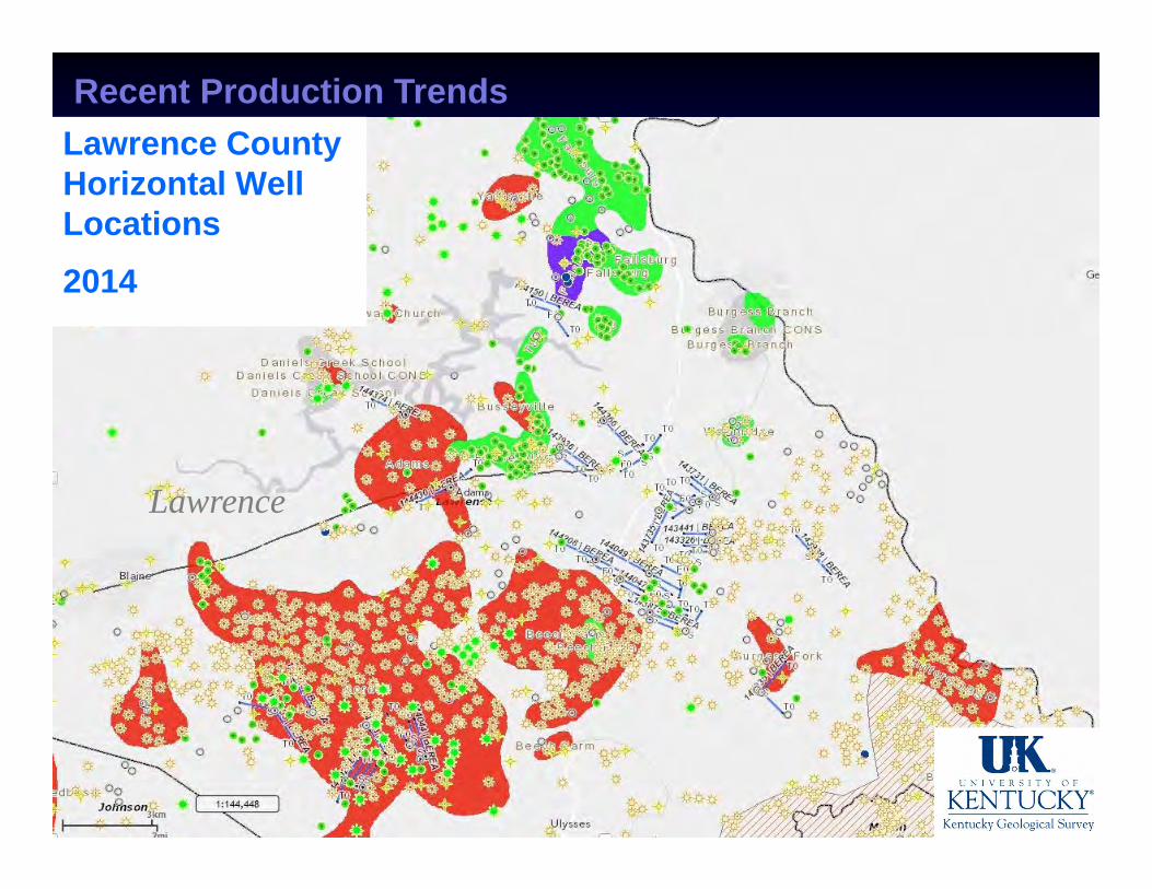
Recent Production TrendsLawrence County Horizontal Well Locations 2014
Lawrence
Recent Production Trends
222.41
0
50
100
150
200
250
2000 2005 2010 2015
Oil prod
uctio
n (barrels)
Thou
sand
s
GreenupLawrence
2013 production volume for Greenup County is confidential (3 or fewer respondents)
Recent Berea Oil Production, East Kentucky
>10% of statewide production
Recent Production TrendsSummary Initial data shows horizontal drilling has been a
technical success in shallow tight Berea reservoirs Horizontal drilling has dramatically increased
Berea oil production in KY
Determining economic success will require longer term production data
Berea horizontal play spreading into neighboring Boyd and Johnson Counties
Shallow depths (lower costs) part of the interest
Dramatic increases in Greenup and Lawrence County oil production (and for EKY as a whole)
Research Questions
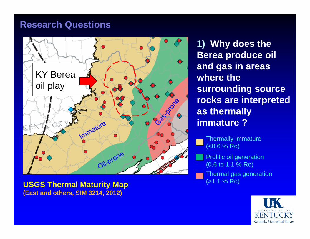
1) Why does the Berea produce oil and gas in areas where the surrounding source rocks are interpreted as thermally immature ?
USGS Thermal Maturity Map(East and others, SIM 3214, 2012)
KY Berea oil play
Thermally immature(<0.6 % Ro)
Prolific oil generation(0.6 to 1.1 % Ro)Thermal gas generation(>1.1 % Ro)
Research Questions
1) Why does the Berea produce oil and gas in areas where the surrounding source rocks are interpreted as thermally immature ?
USGS Thermal Maturity Map(East and others, SIM 3214, 2012)
Thermally immature(<0.6 % Ro)
Prolific oil generation(0.6 to 1.1 % Ro)Thermal gas generation(>1.1 % Ro)
KY Berea oil play
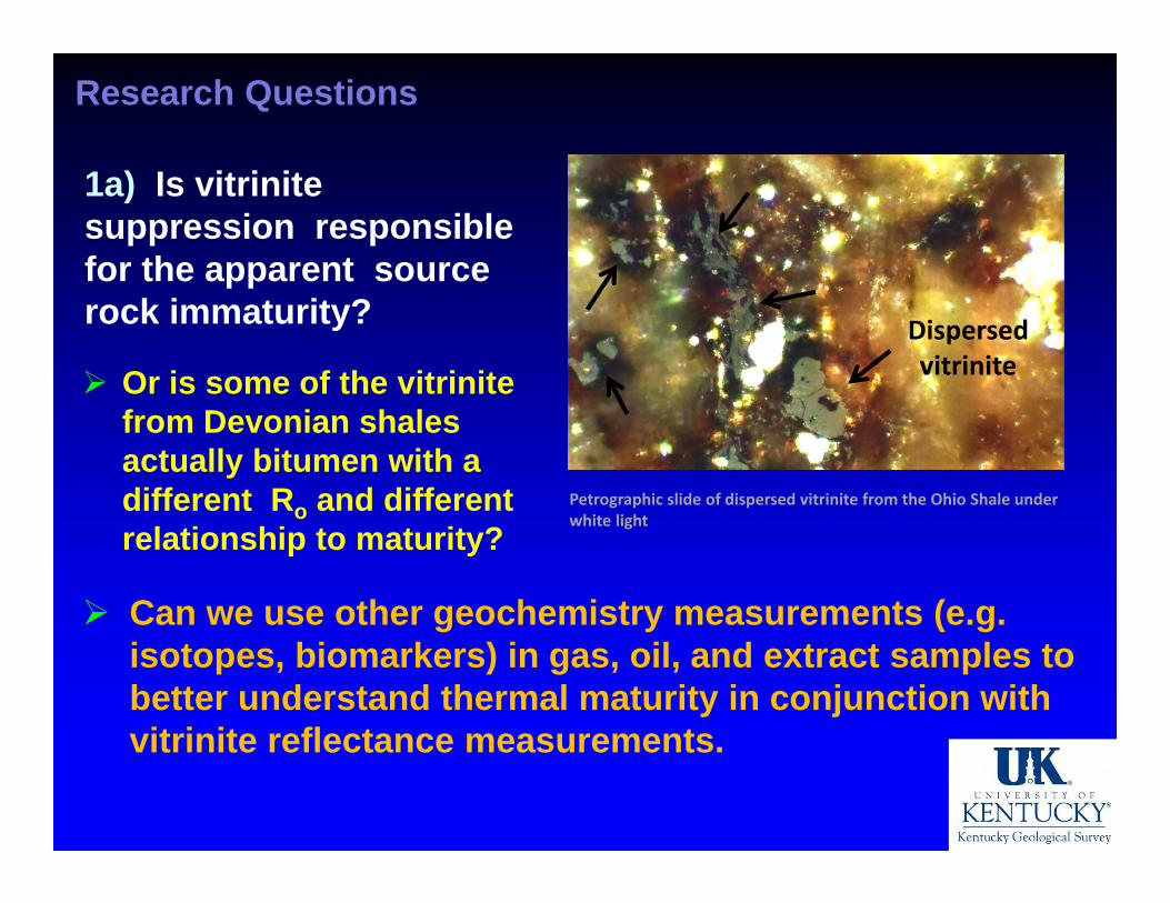
1a) Is vitrinite suppression responsible for the apparent source rock immaturity?
Research Questions
Or is some of the vitrinite from Devonian shales actually bitumen with a different Ro and different relationship to maturity?
Petrographic slide of dispersed vitrinite from the Ohio Shale under white light
Dispersedvitrinite
Can we use other geochemistry measurements (e.g. isotopes, biomarkers) in gas, oil, and extract samples to better understand thermal maturity in conjunction with vitrinite reflectance measurements.
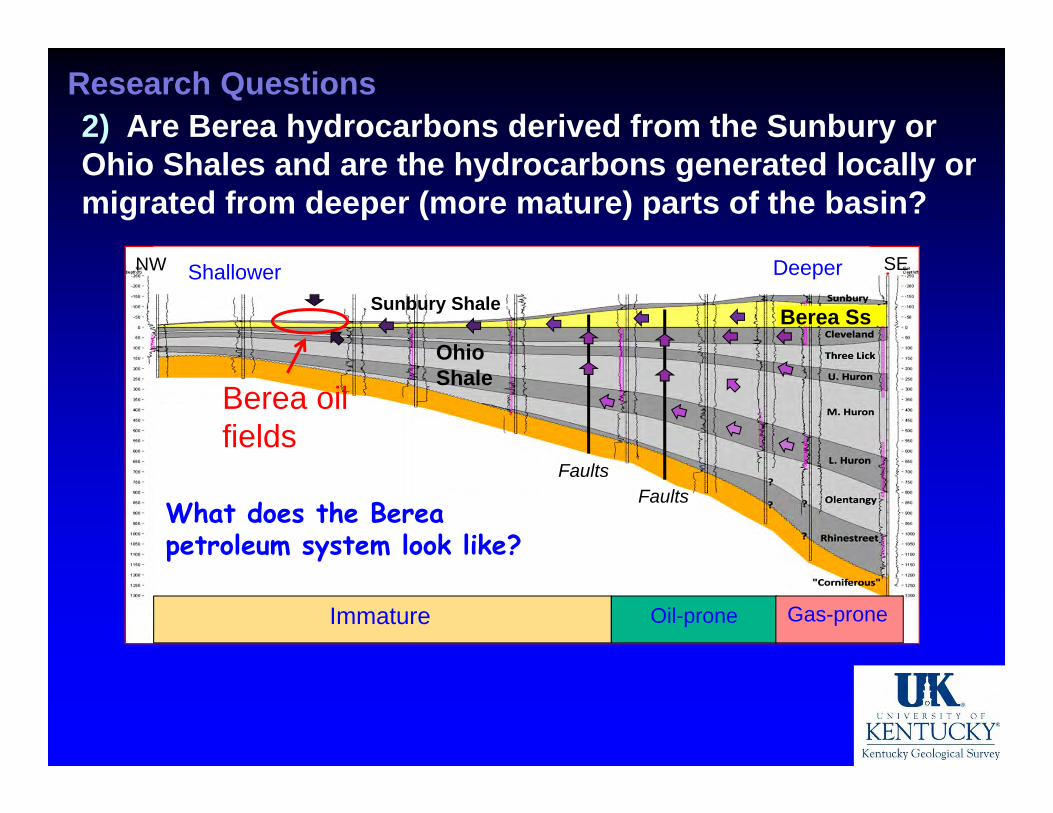
Research Questions2) Are Berea hydrocarbons derived from the Sunbury or Ohio Shales and are the hydrocarbons generated locally or migrated from deeper (more mature) parts of the basin?
Berea oil fields
Immature Gas-proneOil-prone
Ohio Shale
Sunbury Shale Berea Ss
FaultsFaults
Shallower DeeperNW SE
What does the Berea petroleum system look like?
Research Questions
3) What are some of the controls on pay zones, porosity, and permeability in the Berea in Kentucky?
Regional trends in thickness? Sandstone architecture and facies in producing
fields (lateral and vertical variability)? Any structural influences on facies? Any structural influences on oil/gas/water
saturations?
Berea
Berea Sandstone Consortium Project KGS, USGS, OGS, R.J. Lee Group, and 7 industry
partners 18-month study (07/2014- 12/2015) of the Berea
petroleum system Analysis will be conducted along a NW-SE
transect representing thermal maturity range in Ky
Generate regional cross sections, and updated isopach and structure maps of the Berea in KY
Compare geophysical logs, cores, and outcrops to better characterize the Berea petroleum system
Berea Consortium Project
Results will be confidential for one year and then a public report will be published (~Dec. 2016)
Collect and analyze (LC, GC, GCMS) samples of Berea oil and gas to geochemically understand provenance and distribution
Use GCMS and IRMS measurements of extracts and oils to analyze biomarker profiles and carbon isotope composition to interpret hydrocarbon source
Collect and analyze samples of source rocks for TOC, Rock-Eval pyrolysis, vitrinite reflectance, and spectral fluorescence to evaluate thermal maturity