Hall Planning & Engineering, Inc. Page 1 September 17, 2008 Update to the Maybank Highway Widening Traffic Study Executive Summary Introduction This transportation study addresses the section of Maybank Highway from the end of the Stono River Bridge to the signalized intersection at Main Road/Bohicket Road; a 3.75 mile distance. The purpose is to identify effective and balanced improvements to the Maybank Highway area thoroughfare network that accommodate both projected vehicular traffic and the development pattern and sense of character envisioned by Johns Island residents. This requires a balancing of concepts from previous reports; building upon their work. Based on our review, previous efforts either envisioned development compatible with the island--with few traffic details--or provided a detailed understanding of future traffic conditions with less consideration of the community’s desired character. In particular, recommendations from the following two important efforts appear to conflict with each other. Previous Studies The first relevant work, the Johns Island Community Planning workshop, was conducted by the City of Charleston in June 2007. The goal was to build upon past planning efforts for Johns Island, recommendations of the Johns Island Growth Management Committee regarding upcoming development to shape a community plan for the future. The Johns Island community planning workshop recommended continued support of the rural and suburban quality of the island. Workshop attendees clearly recognized the need to enhance policies that yield planned growth without compromising the unique character of Johns Island. Regarding transportation, one of the most significant workshop recommendations was the following: Preserve the tree canopy on Maybank by building a parallel roadway at least 100 feet south of the existing Maybank, then constructing two additional entry roads from Fenwick Hall Allee. The Community Workshop effort also identified an expanded street network. As an alternative to conventional road widening, the workshop report recommends adding parallel roads, where possible, and making additional cross-connections between the primary roads to increase the capacity of the road system (in some cases, additional cross-connections are already planned by way of design requirements for new neighborhoods). This alternative is highly desirable as it allows the preservation of the existing road canopies.
Transcript
Hall Planning & Engineering, Inc. Page 1 September 17, 2008
Update to the Maybank Highway Widening Traffic Study
Executive Summary Introduction This transportation study addresses the section of Maybank Highway from the end of the Stono River Bridge to the signalized intersection at Main Road/Bohicket Road; a 3.75 mile distance. The purpose is to identify effective and balanced improvements to the Maybank Highway area thoroughfare network that accommodate both projected vehicular traffic and the development pattern and sense of character envisioned by Johns Island residents. This requires a balancing of concepts from previous reports; building upon their work. Based on our review, previous efforts either envisioned development compatible with the island--with few traffic details--or provided a detailed understanding of future traffic conditions with less consideration of the community’s desired character. In particular, recommendations from the following two important efforts appear to conflict with each other. Previous Studies The first relevant work, the Johns Island Community Planning workshop, was conducted by the City of Charleston in June 2007. The goal was to build upon past planning efforts for Johns Island, recommendations of the Johns Island Growth Management Committee regarding upcoming development to shape a community plan for the future. The Johns Island community planning workshop recommended continued support of the rural and suburban quality of the island. Workshop attendees clearly recognized the need to enhance policies that yield planned growth without compromising the unique character of Johns Island. Regarding transportation, one of the most significant workshop recommendations was the following:
Preserve the tree canopy on Maybank by building a parallel roadway at least 100 feet south of the existing Maybank, then constructing two additional entry roads from Fenwick Hall Allee.
The Community Workshop effort also identified an expanded street network. As an alternative to conventional road widening, the workshop report recommends adding parallel roads, where possible, and making additional cross-connections between the primary roads to increase the capacity of the road system (in some cases, additional cross-connections are already planned by way of design requirements for new neighborhoods). This alternative is highly desirable as it allows the preservation of the existing road canopies.
Update to the Maybank Highway Area Transportation Study Summary (Johns Island, SC)
Hall Planning & Engineering, Inc. Page 2
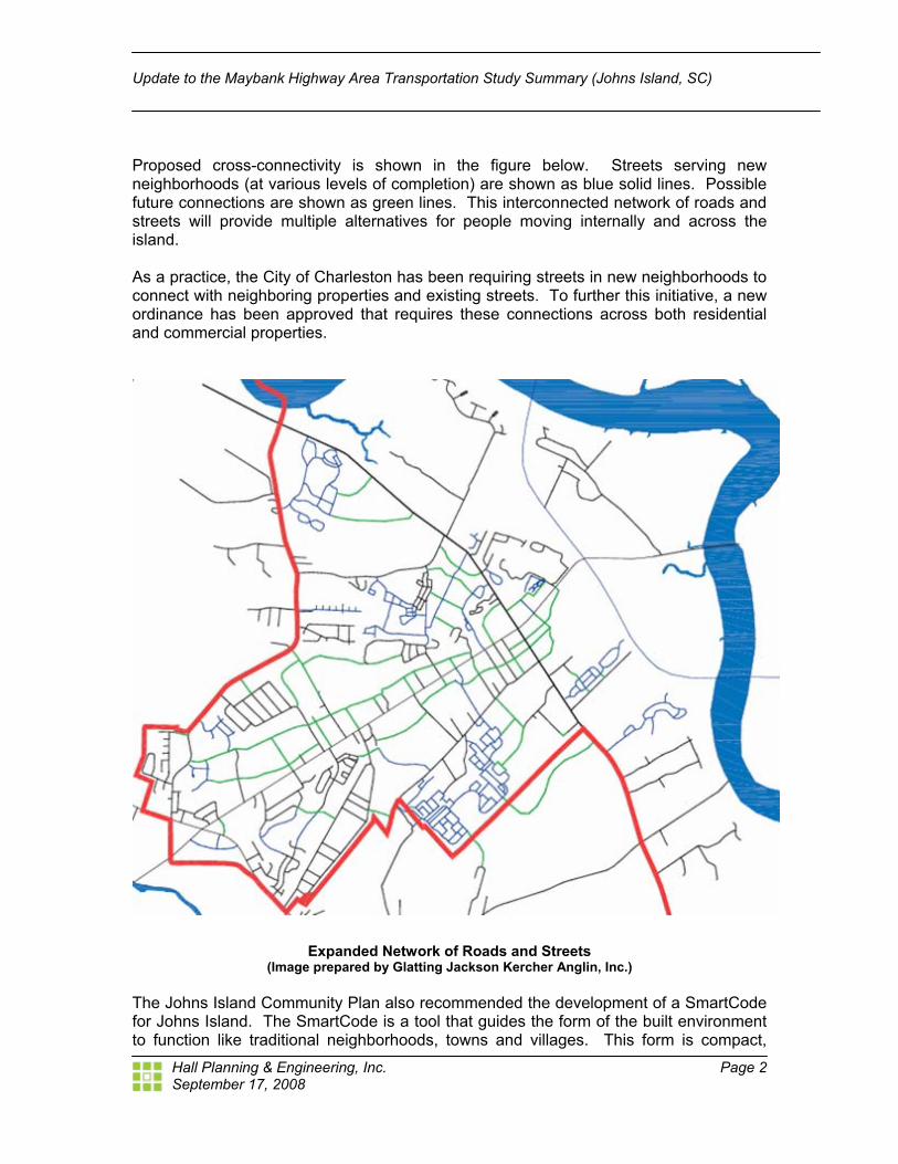
Proposed cross-connectivity is shown in the figure below. Streets serving new neighborhoods (at various levels of completion) are shown as blue solid lines. Possible future connections are shown as green lines. This interconnected network of roads and streets will provide multiple alternatives for people moving internally and across the island. As a practice, the City of Charleston has been requiring streets in new neighborhoods to connect with neighboring properties and existing streets. To further this initiative, a new ordinance has been approved that requires these connections across both residential and commercial properties.
Expanded Network of Roads and Streets (Image prepared by Glatting Jackson Kercher Anglin, Inc.)
The Johns Island Community Plan also recommended the development of a SmartCode for Johns Island. The SmartCode is a tool that guides the form of the built environment to function like traditional neighborhoods, towns and villages. This form is compact,
September 17, 2008
Update to the Maybank Highway Area Transportation Study Summary (Johns Island, SC)
Hall Planning & Engineering, Inc. Page 3
walkable and mixed-use, and is meant to be comfortable, safe and ecologically sustainable. It allows a mix of uses within the neighborhood, so its residents don’t have to drive to satisfy every trip. It simultaneously preserves the form of urbanism and open lands. The SmartCode is also transect-based. That means it codes the natural, rural, suburban and urban landscape into patterns of density and variety to yield traditional towns and villages we admire. The operating principle of the Transect is that certain forms belong in certain environments; for example, an apartment building belongs in a more urban setting, and a large lot house belongs in a more rural setting. The Johns Island District SmartCode is currently being developed as a result of a charrette conducted by Town Planning & Urban Design Collaborative (TPUDC) in late May/early June 2008. This effort will provide recommendations for the form, intensity and character of the proposed transect (T) zones (a sample is illustrated below). There is a special focus on context and placemaking rather than the contemporary focus on separated land use and wide setbacks.
Sketch of Proposed T4 area in Johns Island
(Image produced by TPUDC)
September 17, 2008
Update to the Maybank Highway Area Transportation Study Summary (Johns Island, SC)
Hall Planning & Engineering, Inc. Page 4
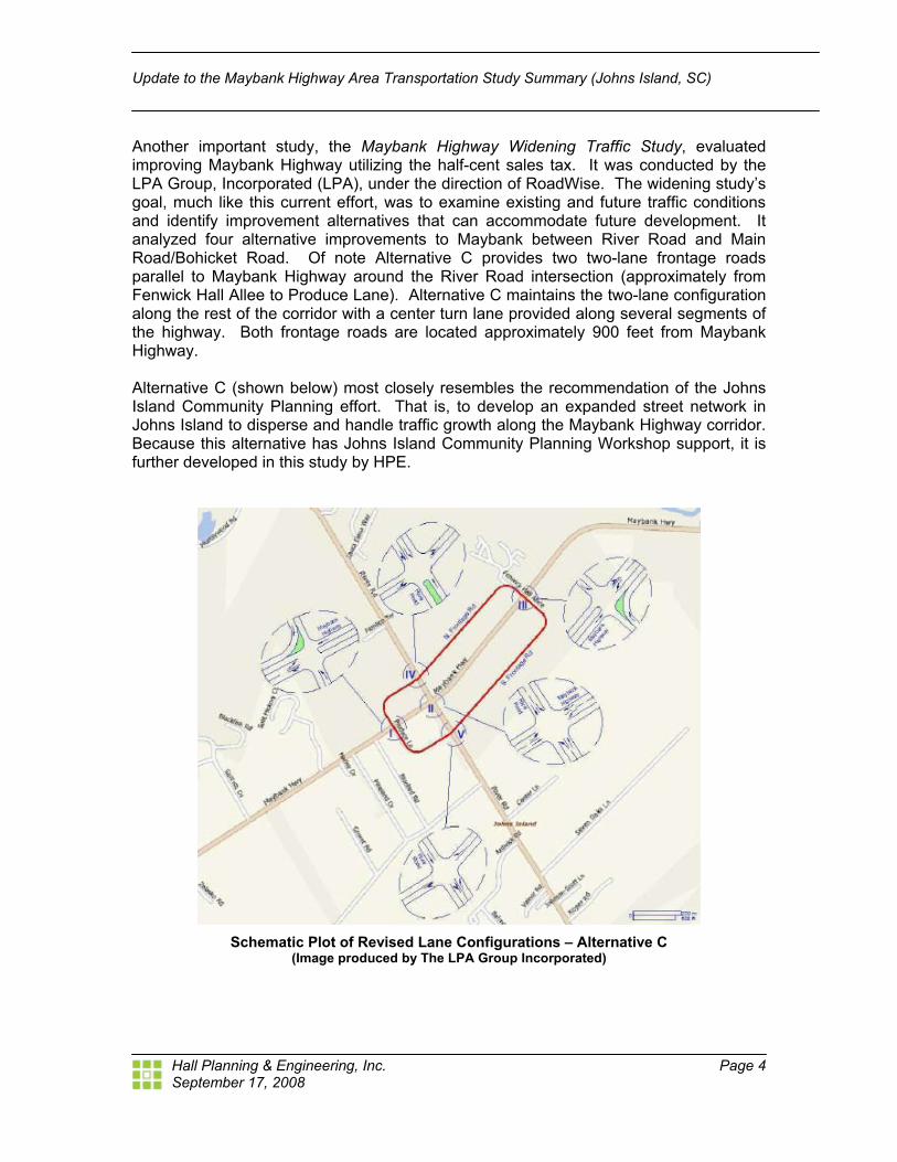
Another important study, the Maybank Highway Widening Traffic Study, evaluated improving Maybank Highway utilizing the half-cent sales tax. It was conducted by the LPA Group, Incorporated (LPA), under the direction of RoadWise. The widening study’s goal, much like this current effort, was to examine existing and future traffic conditions and identify improvement alternatives that can accommodate future development. It analyzed four alternative improvements to Maybank between River Road and Main Road/Bohicket Road. Of note Alternative C provides two two-lane frontage roads parallel to Maybank Highway around the River Road intersection (approximately from Fenwick Hall Allee to Produce Lane). Alternative C maintains the two-lane configuration along the rest of the corridor with a center turn lane provided along several segments of the highway. Both frontage roads are located approximately 900 feet from Maybank Highway. Alternative C (shown below) most closely resembles the recommendation of the Johns Island Community Planning effort. That is, to develop an expanded street network in Johns Island to disperse and handle traffic growth along the Maybank Highway corridor. Because this alternative has Johns Island Community Planning Workshop support, it is further developed in this study by HPE.
Schematic Plot of Revised Lane Configurations – Alternative C
(Image produced by The LPA Group Incorporated)
September 17, 2008
Update to the Maybank Highway Area Transportation Study Summary (Johns Island, SC)
Hall Planning & Engineering, Inc. Page 5
Ultimately, the widening study recommended a center turn lane and two through lanes in each direction along Maybank Highway if the I-526 extension is constructed. If I-526 is not constructed, a center turn lane and two through lanes in each direction should be designed only in the vicinity of the intersections of Maybank Highway at Main Road/Bohicket Road and River Road. Presentations to the public and County Council have since led to a recommended four lane section with raised median along the corridor. This section includes a meandering multi-use path and represents a more aesthetically appealing section based on public input. Current Update This update focuses on further evaluation and refinement of the Maybank Highway Widening Traffic Study, commissioned by RoadWise. Specifically, it tests the parallel network alternative proposed as a result of the Johns Island Community Planning Workshop and subsequently tested, in part, in the Maybank Highway Widening Traffic Study. Ultimately it expands upon the widening study’s analysis of Alternative C utilizing the broader network identified by the Community Workshop effort. The study began by examining, in detail, traffic counts commissioned by LPA during the generation of the Maybank Highway Widening Traffic Study. These counts were analyzed to better understand current travel patterns in the area with particular attention to movement at intersections. This analysis formed the basis of the network that is tested. The counts revealed a heavy westbound movement on Maybank turning right and left at River Road all day long, not just during peak hours. The total number of vehicles from the east turning right (northbound) and left (southbound) represent 40 percent of all the approach vehicles. This is over twice the turning movement a standard intersection of this configuration is usually required to handle and is the main reason the future carrying capacity of the intersection is limited. This observation, more than any, supports a grid network that will disperse traffic intending to turn off of Maybank at multiple locations. To address this unique traffic pattern, HPE recommends the use of an expanded street network to disperse traffic along a parallel system of two-lane streets. Particularly, a “pitchfork” pattern (see below) of streets and intersections should be developed near the Stono River Bridge and potential I-526 interchange at the Fenwick Hall Allee. This “pitchfork” pattern will alleviate the most heavily congested segment in the region during all times of day.
September 17, 2008
Update to the Maybank Highway Area Transportation Study Summary (Johns Island, SC)
Hall Planning & Engineering, Inc. Page 6
Proposed Pitchfork Network without the I-526 Expansion
(Blue: Existing and Planned/Approved; Green: Proposed; Red: Proposed Optional) If a carefully designed I-526 interchange is developed, the following network will be needed to alleviate increased traffic generated by interstate expansion. It includes the interchange, a southbound flyover from the bridge and a .25 mile widening of Maybank Highway to four lanes from the interchange to Fenwick Hall Allee (shown on the graphic in purple).
September 17, 2008
Update to the Maybank Highway Area Transportation Study Summary (Johns Island, SC)
Hall Planning & Engineering, Inc. Page 7
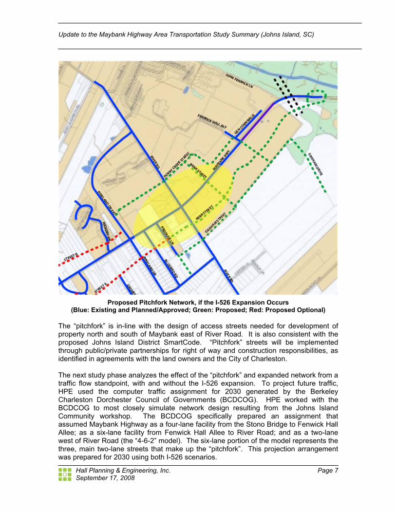
Proposed Pitchfork Network, if the I-526 Expansion Occurs
(Blue: Existing and Planned/Approved; Green: Proposed; Red: Proposed Optional) The “pitchfork” is in-line with the design of access streets needed for development of property north and south of Maybank east of River Road. It is also consistent with the proposed Johns Island District SmartCode. “Pitchfork” streets will be implemented through public/private partnerships for right of way and construction responsibilities, as identified in agreements with the land owners and the City of Charleston. The next study phase analyzes the effect of the “pitchfork” and expanded network from a traffic flow standpoint, with and without the I-526 expansion. To project future traffic, HPE used the computer traffic assignment for 2030 generated by the Berkeley Charleston Dorchester Council of Governments (BCDCOG). HPE worked with the BCDCOG to most closely simulate network design resulting from the Johns Island Community workshop. The BCDCOG specifically prepared an assignment that assumed Maybank Highway as a four-lane facility from the Stono Bridge to Fenwick Hall Allee; as a six-lane facility from Fenwick Hall Allee to River Road; and as a two-lane west of River Road (the “4-6-2” model). The six-lane portion of the model represents the three, main two-lane streets that make up the “pitchfork”. This projection arrangement was prepared for 2030 using both I-526 scenarios.
September 17, 2008
Update to the Maybank Highway Area Transportation Study Summary (Johns Island, SC)
Hall Planning & Engineering, Inc. Page 8
HPE, then, matched the three-step methodology employed by LPA in its widening study to assist in comparing the alternatives tested. Those steps are as follows:
1. Calculated growth factors by comparing 2003 Annual Average Daily Traffic (AADT) to the projected 2030 AADT, with and without the I-526 extension. Both are provided by the BCDCOG.
2. These growth rates were then applied to peak hour turning movement counts taken in 2006 for the Maybank Highway Widening Traffic Study to establish 2030 peak hour volumes.
3. The resulting traffic volumes were then distributed along the new roadway network.
The outcome of the Synchro analysis proves the expanded network approach handles the projected traffic from the BCDCOG 4-6-2 traffic assignment. The analysis showed that the proposed network, without the I-526 expansion and if the I-526 expansion occurs, would operate at acceptable levels of service at all intersections. The arterial level of service also showed acceptable levels of operation. Design The Johns Island Community Plan recommended that Maybank highway between River Road and Main Road be reconfigured into “Town and Country” sections. These would consist of several compact, town-like or gathering place activity centers along Maybank Highway. Within these centers, Maybank highway would assume a geometry appropriate for passage through a “town” section at the edges of these gathering places, the road would take on a “country road” configuration appropriate to reflect Johns Island character. Country road characteristics include tree preservation, use of typical rural drainage swales and a multi-use path to accommodate bicyclists and pedestrians. Proper design of the proposed new streets is critical to achieving the overall character and walkability desired for Johns Island, specifically in the three gathering place nodes identified by the City (see below).
September 17, 2008
Update to the Maybank Highway Area Transportation Study Summary (Johns Island, SC)
Hall Planning & Engineering, Inc. Page 9
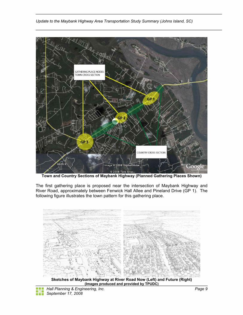
Town and Country Sections of Maybank Highway (Planned Gathering Places Shown)
The first gathering place is proposed near the intersection of Maybank Highway and River Road, approximately between Fenwick Hall Allee and Pineland Drive (GP 1). The following figure illustrates the town pattern for this gathering place.
Sketches of Maybank Highway at River Road Now (Left) and Future (Right)
(Images produced and provided by TPUDC)
September 17, 2008
Update to the Maybank Highway Area Transportation Study Summary (Johns Island, SC)
Hall Planning & Engineering, Inc. Page 10
The second gathering place is approximately half-way between River Road and Main Road between Zelasko Road and Walter Drive. A third gathering place is proposed for the intersection at Main Road/Bohicket Road, illustrated below.
Sketches of Maybank Highway at Main/Bohicket Road Now (Left) & Future (Right)
(Images produced and provided by TPUDC)
September 17, 2008
Update to the Maybank Highway Area Transportation Study Summary (Johns Island, SC)
Hall Planning & Engineering, Inc. Page 11
Pedestrian comfort and safety depend on traffic speeds managed to 30 mph or less, thus assuring walkability. Traffic speeds on Maybank Highway should be managed to walkable levels in the town-like conditions of the gathering places. Outside the gathering places target speeds of 35 mph are appropriate. The key design elements to manage traffic speeds include on-street parking and lane width reductions, as described below. NOTE: All street dimensions are measured curb-face to curb-face. The following figure illustrates the proposed cross section for Maybank Highway as it traverses the gathering places. The cross section includes one 10’ travel lane in each direction, with 8’ parallel parking on each side of the street, for a total pavement width 36 feet. Sidewalk widths and planting styles consistent with the town-like atmosphere design are also shown on this cross section.
Proposed Commercial Street Section
September 17, 2008
Update to the Maybank Highway Area Transportation Study Summary (Johns Island, SC)
Hall Planning & Engineering, Inc. Page 12
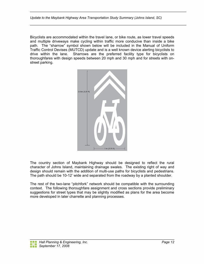
Bicyclists are accommodated within the travel lane, or bike route, as lower travel speeds and multiple driveways make cycling within traffic more conducive than inside a bike path. The “sharrow” symbol shown below will be included in the Manual of Uniform Traffic Control Devises (MUTCD) update and is a well known device alerting bicyclists to drive within the lane. Sharrows are the preferred facility type for bicyclists on thoroughfares with design speeds between 20 mph and 30 mph and for streets with on-street parking.
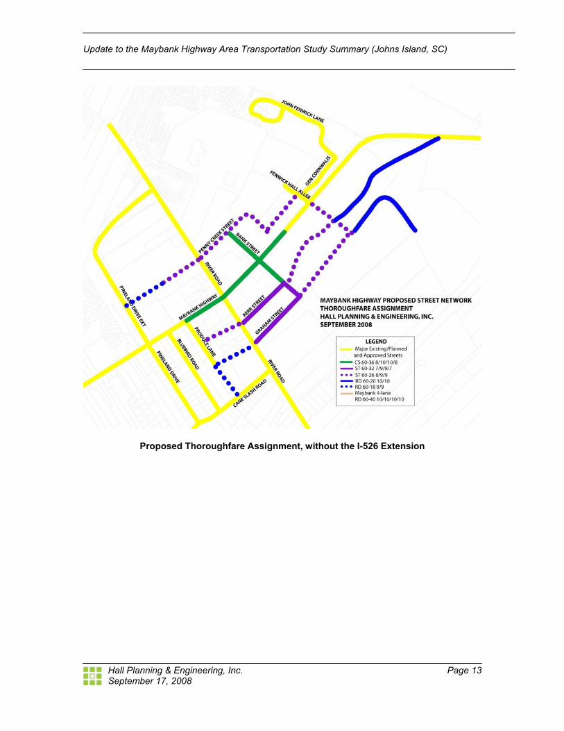
The country section of Maybank Highway should be designed to reflect the rural character of Johns Island, maintaining drainage swales. The existing right of way and design should remain with the addition of multi-use paths for bicyclists and pedestrians. The path should be 10-12’ wide and separated from the roadway by a planted shoulder. The rest of the two-lane “pitchfork” network should be compatible with the surrounding context. The following thoroughfare assignment and cross sections provide preliminary suggestions for street types that may be slightly modified as plans for the area become more developed in later charrette and planning processes.
September 17, 2008
Update to the Maybank Highway Area Transportation Study Summary (Johns Island, SC)
Hall Planning & Engineering, Inc. Page 13
Proposed Thoroughfare Assignment, without the I-526 Extension
September 17, 2008
Update to the Maybank Highway Area Transportation Study Summary (Johns Island, SC)
Hall Planning & Engineering, Inc. Page 14
Proposed Thoroughfare Assignment, if the I-526 Extension Occurs The illustrated thoroughfare assignment provides suggestions for street types and their location based on the current gathering place concepts. The Commercial Street section is described above, and other street types are detailed below.
September 17, 2008
Update to the Maybank Highway Area Transportation Study Summary (Johns Island, SC)
Hall Planning & Engineering, Inc. Page 15
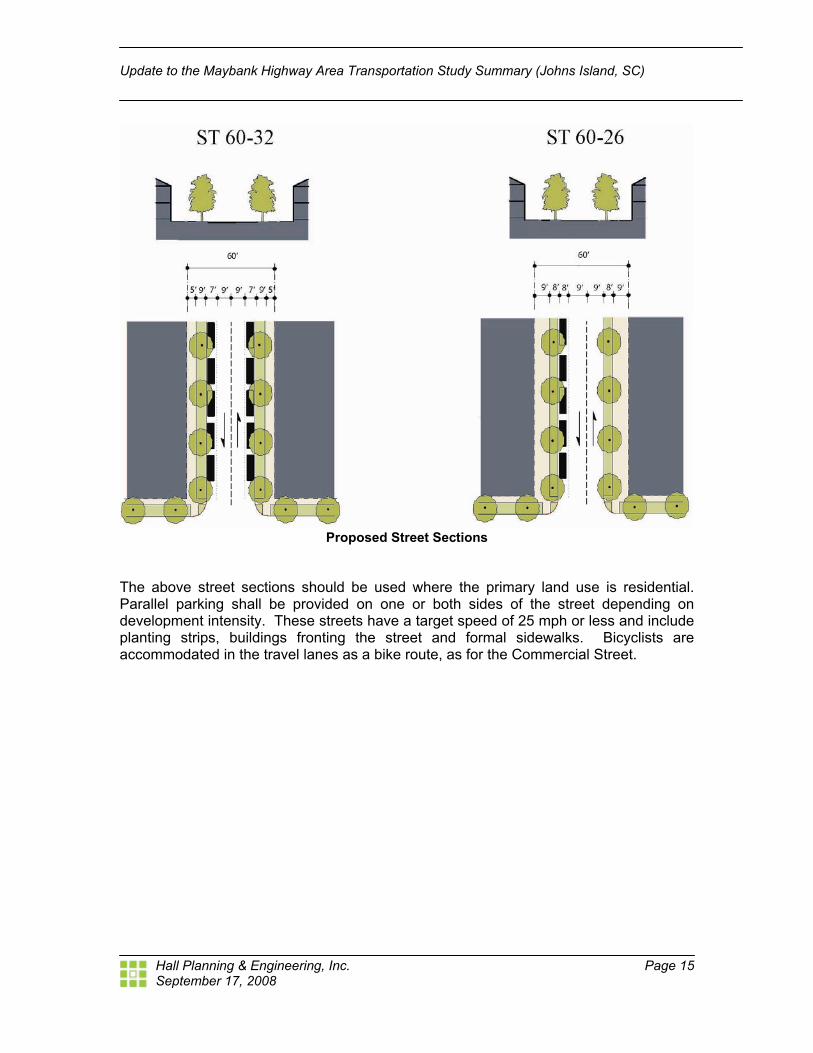
Proposed Street Sections
The above street sections should be used where the primary land use is residential. Parallel parking shall be provided on one or both sides of the street depending on development intensity. These streets have a target speed of 25 mph or less and include planting strips, buildings fronting the street and formal sidewalks. Bicyclists are accommodated in the travel lanes as a bike route, as for the Commercial Street.
September 17, 2008
Update to the Maybank Highway Area Transportation Study Summary (Johns Island, SC)
Hall Planning & Engineering, Inc. Page 16
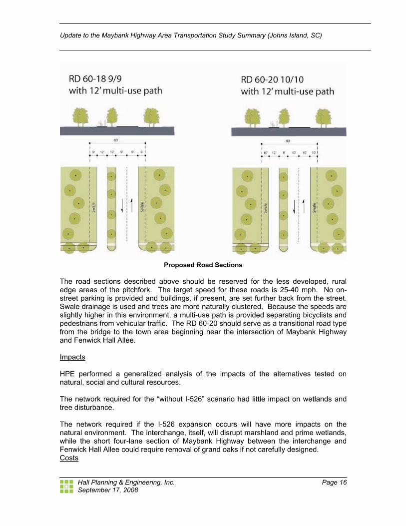
Proposed Road Sections
The road sections described above should be reserved for the less developed, rural edge areas of the pitchfork. The target speed for these roads is 25-40 mph. No on-street parking is provided and buildings, if present, are set further back from the street. Swale drainage is used and trees are more naturally clustered. Because the speeds are slightly higher in this environment, a multi-use path is provided separating bicyclists and pedestrians from vehicular traffic. The RD 60-20 should serve as a transitional road type from the bridge to the town area beginning near the intersection of Maybank Highway and Fenwick Hall Allee. Impacts HPE performed a generalized analysis of the impacts of the alternatives tested on natural, social and cultural resources. The network required for the “without I-526” scenario had little impact on wetlands and tree disturbance. The network required if the I-526 expansion occurs will have more impacts on the natural environment. The interchange, itself, will disrupt marshland and prime wetlands, while the short four-lane section of Maybank Highway between the interchange and Fenwick Hall Allee could require removal of grand oaks if not carefully designed. Costs
September 17, 2008
Update to the Maybank Highway Area Transportation Study Summary (Johns Island, SC)
Hall Planning & Engineering, Inc. Page 17
HPE employed the following procedure to estimate roadway improvement cost: 1. To estimate the cost of Maybank Highway-related roadway improvements, HPE
utilized a series of roadway cost estimating spreadsheets prepared by the North Carolina Department of Transportation and updated June 28, 2007 (These spreadsheets were used for the Carolina Bays Parkway Extension Feasibility Study Report, prepared jointly by the NCDOT and SCDOT)
2. Cost estimates were calculated based on the type of roadway improvement proposed
3. Improvement length for each type of roadway was calculated utilizing the “Maybank Highway Proposed Street Network Thoroughfare Assignment” shown in the figure below.
4. A terrain adjustment factor was applied to the roadway cost calculations (in this case,
a factor of 1.00, for “coastal” conditions, was utilized) 5. Right of way cost was not included in the estimates as it is expected the necessary
right of way will be donated
6. The resulting 2007 cost estimates were inflated by a +7% adjustment factor supplied by the North Carolina Department of Transportation to approximate 2008 levels
7. HPE’s NCDOT based cost estimate for Maybank Highway was then compared with a Maybank Highway estimate spreadsheet prepared by the LPA group. On a cost per mile basis, the LPA estimate was found to be less than 2% higher than HPE’s estimate
8. HPE assumed the LPA estimate was the most accurate, due to local knowledge. Consequently, HPE increased all roadway estimates by the difference
9. Finally, all HPE 2008 roadway cost estimates were projected five years (to 2013) at 5% per year (as utilized by the LPA Group)
September 17, 2008
Update to the Maybank Highway Area Transportation Study Summary (Johns Island, SC)
Hall Planning & Engineering, Inc. Page 18
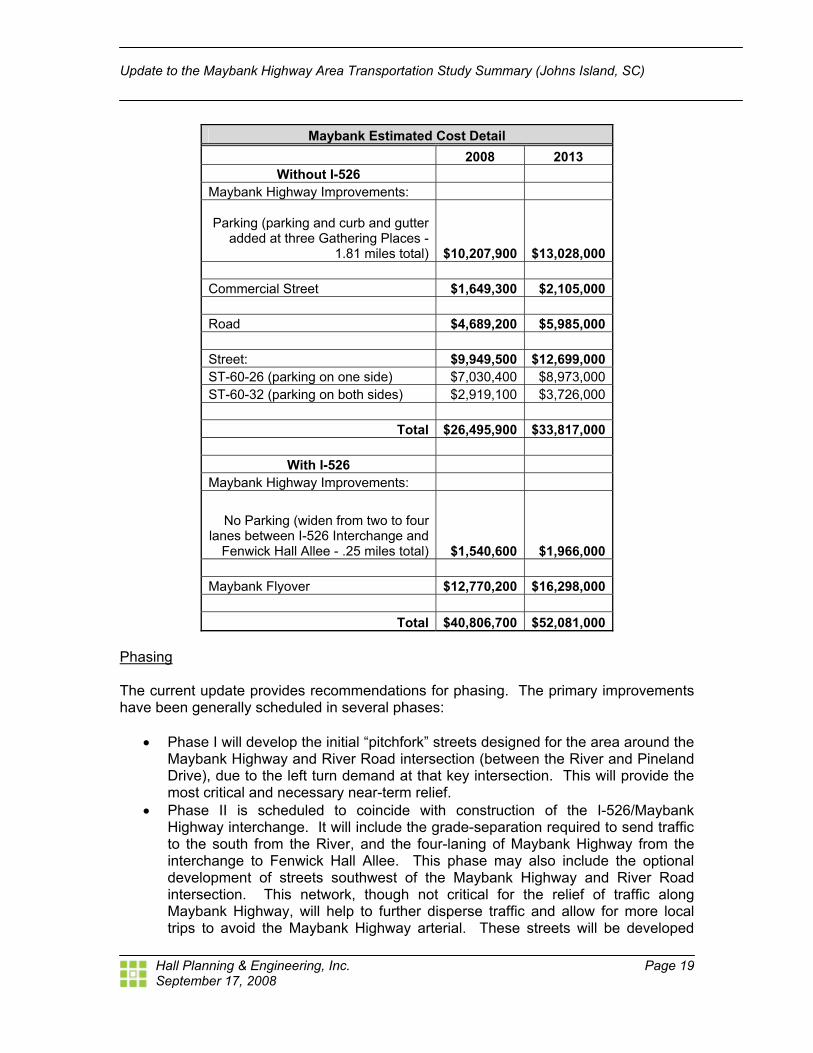
The following table summarizes the results for the both I-526 scenarios. Without the I-526 extension, the proposed network would cost $26.5 million in 2008 and $33.4 million in 2013 dollars. If the I-526 extension is constructed, a flyover from the bridge and additional improvements to Maybank Highway are required adding $14.3 million and $18.3 million in 2008 and 2013 respectively.
September 17, 2008
Update to the Maybank Highway Area Transportation Study Summary (Johns Island, SC)
Hall Planning & Engineering, Inc. Page 19
Maybank Estimated Cost Detail 2008 2013
Without I-526 Maybank Highway Improvements:
Parking (parking and curb and gutter added at three Gathering Places -
1.81 miles total) $10,207,900 $13,028,000
Commercial Street $1,649,300 $2,105,000
Road $4,689,200 $5,985,000 Street: $9,949,500 $12,699,000 ST-60-26 (parking on one side) $7,030,400 $8,973,000 ST-60-32 (parking on both sides) $2,919,100 $3,726,000
Total $26,495,900 $33,817,000
With I-526
Maybank Highway Improvements:
No Parking (widen from two to four lanes between I-526 Interchange and
Fenwick Hall Allee - .25 miles total) $1,540,600 $1,966,000
Maybank Flyover $12,770,200 $16,298,000
Total $40,806,700 $52,081,000 Phasing The current update provides recommendations for phasing. The primary improvements have been generally scheduled in several phases:
! Phase I will develop the initial “pitchfork” streets designed for the area around the Maybank Highway and River Road intersection (between the River and Pineland Drive), due to the left turn demand at that key intersection. This will provide the most critical and necessary near-term relief.
! Phase II is scheduled to coincide with construction of the I-526/Maybank Highway interchange. It will include the grade-separation required to send traffic to the south from the River, and the four-laning of Maybank Highway from the interchange to Fenwick Hall Allee. This phase may also include the optional development of streets southwest of the Maybank Highway and River Road intersection. This network, though not critical for the relief of traffic along Maybank Highway, will help to further disperse traffic and allow for more local trips to avoid the Maybank Highway arterial. These streets will be developed
September 17, 2008
Update to the Maybank Highway Area Transportation Study Summary (Johns Island, SC)
Hall Planning & Engineering, Inc. Page 20
only if the property is developed in accordance with City of Charleston requirements for connectivity.