Page 1 of 35 ASX Release 25 May, 2017 Updated McIntosh Graphite Mineral Resource Hexagon Resources Limited (ASX: HXG) is pleased to report an updated Mineral Resource estimate for the McIntosh Flake Graphite Project, located in Western Australia, of 21.3 million tonnes grading 4.5 % Total Graphitic Carbon (TGC). This represents a 3% increase in terms of tonnes and contained graphite and a 10% improvement in the proportion of material classified as Indicated from Inferred compared to the Mineral Resource estimate reported to ASX on 15 February 2017. The updated Mineral Resource estimate was carried out by Hexagon to include additional drilling results obtained from the Emperor deposit, since the February report, and re-interpretation and estimation of the Longtom deposit using a 3% TGC cut-off grade. All four reported resource models (Table 1 and Figure 1) at the McIntosh Project have been verified by Optiro Pty Ltd, a leading, independent resource and mining consultancy group with experience in assessing graphite resources. Hexagon’s Managing Director, Mike Rosenstreich commented “This upgrade is part of the ongoing initiative by the Company to increase the scale and longevity of the project and provides a solid basis for the current mining plans that underpin Hexagon’s stage-one pre-feasibility study (PFS) and also gives Hexagon’s team “ownership” of all the Mineral Resource estimates, which importantly underwent detailed independent scrutiny. We continue to focus on the PFS and expect to provide a report of key PFS outcomes next week.” Table 1. McIntosh Flake Graphite Project Mineral Resource as at May 2017 reported by deposit and above a 3% TGC cut-off grade. Deposit JORC Classification Material Type Tonnes (Mt) TGC % Contained Graphite (Kt) Emperor Indicated Oxide - - - Primary 8.2 4.3 352 Inferred Oxide - - - Primary 5.3 4.5 235 Indicated + Inferred Oxide + Primary 13.4 4.5 587 Longtom Indicated Oxide 0.7 4.7 34.2 Primary 3.5 5.0 173.4 Inferred Oxide - - - Primary 1.3 5.2 66.9 Indicated + Inferred Oxide + Primary 5.5 5.0 274.3 Wahoo Indicated Oxide 0.1 4.2 3.5 Primary 1.1 4.2 44.3 Inferred Oxide 0.1 4.1 3.4 Primary 0.5 4.2 22.4 Indicated + Inferred Oxide + Primary 1.7 4.2 70.1 Barracuda Inferred Oxide 0.2 4.5 11.1 Primary 0.5 4.4 21.1 Inferred Oxide + Primary 0.7 4.4 32.2 Total Indicated + Inferred Oxide + Primary 21.3 4.5 963.6 Note: Rounding may result in differences in totals for tonnage and grade
Transcript
Page 1 of 35
ASX Release 25 May, 2017
Updated McIntosh Graphite Mineral Resource
Hexagon Resources Limited (ASX: HXG) is pleased to report an updated Mineral Resource estimate for the McIntosh Flake Graphite Project, located in Western Australia, of 21.3 million tonnes grading 4.5 % Total Graphitic Carbon (TGC).
This represents a 3% increase in terms of tonnes and contained graphite and a 10% improvement in the proportion of material classified as Indicated from Inferred compared to the Mineral Resource estimate reported to ASX on 15 February 2017.
The updated Mineral Resource estimate was carried out by Hexagon to include additional drilling results obtained from the Emperor deposit, since the February report, and re-interpretation and estimation of the Longtom deposit using a 3% TGC cut-off grade. All four reported resource models (Table 1 and Figure 1) at the McIntosh Project have been verified by Optiro Pty Ltd, a leading, independent resource and mining consultancy group with experience in assessing graphite resources.
Hexagon’s Managing Director, Mike Rosenstreich commented “This upgrade is part of the ongoing initiative by the Company to increase the scale and longevity of the project and provides a solid basis for the current mining plans that underpin Hexagon’s stage-one pre-feasibility study (PFS) and also gives Hexagon’s team “ownership” of all the Mineral Resource estimates, which importantly underwent detailed independent scrutiny. We continue to focus on the PFS and expect to provide a report of key PFS outcomes next week.”
Table 1. McIntosh Flake Graphite Project Mineral Resource as at May 2017 reported by deposit and above a 3% TGC cut-off grade.
Deposit JORC Classification Material Type Tonnes (Mt) TGC % Contained
Total Indicated + Inferred Oxide + Primary 21.3 4.5 963.6
Note: Rounding may result in differences in totals for tonnage and grade
Page 2 of 35
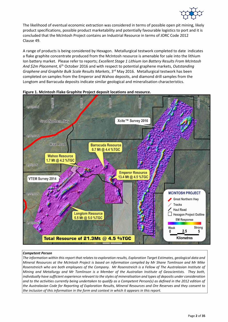
The likelihood of eventual economic extraction was considered in terms of possible open pit mining, likely product specifications, possible product marketability and potentially favourable logistics to port and it is concluded that the McIntosh Project contains an Industrial Resource in terms of JORC Code 2012 Clause 49. A range of products is being considered by Hexagon. Metallurgical testwork completed to date indicates a flake graphite concentrate produced from the McIntosh resource is amenable for sale into the lithium Ion battery market. Please refer to reports; Excellent Stage 1 Lithium Ion Battery Results From McIntosh And $2m Placement, 6th October 2016 and with respect to potential graphene markets, Outstanding Graphene and Graphite Bulk Scale Results Markets, 3rd May 2016. Metallurgical testwork has been completed on samples from the Emperor and Wahoo deposits, and diamond drill samples from the Longtom and Barracuda deposits indicate similar geological and mineralisation characteristics. Figure 1. McIntosh Flake Graphite Project deposit locations and resource.
Competent Person The information within this report that relates to exploration results, Exploration Target Estimates, geological data and Mineral Resources at the McIntosh Project is based on information compiled by Mr Shane Tomlinson and Mr Mike Rosenstreich who are both employees of the Company. Mr Rosenstreich is a Fellow of The Australasian Institute of Mining and Metallurgy and Mr Tomlinson is a Member of the Australian Institute of Geoscientists. They both, individually have sufficient experience relevant to the styles of mineralisation and types of deposits under consideration and to the activities currently being undertaken to qualify as a Competent Person(s) as defined in the 2012 edition of the Australasian Code for Reporting of Exploration Results, Mineral Resources and Ore Reserves and they consent to the inclusion of this information in the form and context in which it appears in this report.
Page 3 of 35
Contact Mike Rosenstreich - Managing Director Tel: +61 410 576 062 [email protected]
JORC Table 1 Summary
Geology – interpretation was undertaken based on a combination of geological logging data from drill holes, surface mapping and modelled conductive plates from the VTEM survey of 2014.
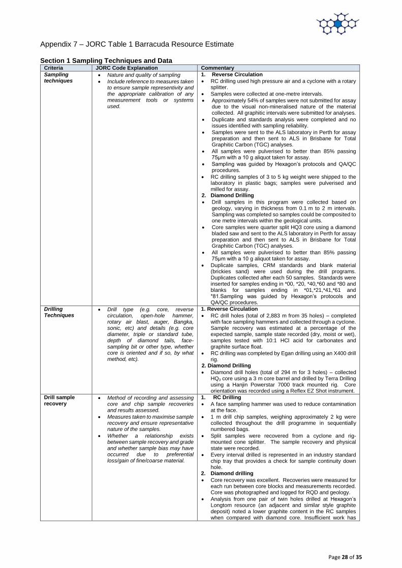
Drilling method – the drilling method used is a combination of reverse circulation “RC” and diamond. The mineralisation for Emperor is defined by 9 RC drill holes for a total of 1,134 m, 21 diamond drill holes for a total of 2,940.5 m and 9 RC precollar / diamond tail holes for 1,369.3 m. The mineralisation for Longtom is defined by 37 RC drill holes for a total of 4,146 m, 1 diamond drill hole for a total of 54.9 m and 4 RC precollar / diamond tail holes for 620.6 m. The mineralisation for Wahoo is defined by 26 RC drill holes for a total of 2,023 m and 11 diamond drill holes for a total of 1,257.8 m. The mineralisation for Barracuda is defined by 35 RC drill holes for a total of 2,883m and 3 diamond drill holes for a total of 294.0m.
Sampling – one-metre drill chip samples were collected throughout the RC drill programme in sequentially numbered bags. Core samples from diamond drill holes were collected based on geology and a minimum interval of 1m and a maximum of 2m.
Sub-sampling - analysis was undertaken at ALS laboratory where samples initially undergo a coarse crush using a jaw crusher to better than 70% passing 6mm. Samples exceeding 3 kg were spilt using a Jones Riffle Splitter 50:50. Pulverising was completed to 85% passing 75μm in preparation for analysis.
Sample analysis method – all samples were sent to ALS for preparation and for Total Graphitic Carbon (TGC), Total Carbon and Total Sulfur (S) analyses. A 0.1 g sample is leached with dilute hydrochloric acid to remove inorganic carbon. After filtering, washing and drying the remaining sample is roasted at 425°C to remove organic carbon. The roasted residue is analysed for carbon using a high temperature LECO furnace with infrared detection for percentage units.
Duplicate analysis and analysis of Certified Reference Material (standards) and blanks was completed and no issues identified with sampling reliability or contamination.
Estimation methodology – grade estimation was undertaken using Surpac software to model graphitic mineralisation using a nominal 3% TGC cut-off grade and to estimate TGC by ordinary kriging at Emperor, Longtom and Wahoo and inverse distance (cubed) at Barracuda.
Resource Classification – classification is based on confidence in geological and grade continuity using the drilling density, geological model, modelled grade continuity and conditional bias measures (slope of the regression and kriging efficiency) as criteria. Indicated Mineral Resources are defined where the drill spacing is sufficient to assume geological and grade continuity and where diamond drill samples have been assessed for graphite quality. As a general rule, drill spacing of 40 m by 40 m or less resulted in an Indicated classification for Emperor and Wahoo and areas with broader spacing are classified as Inferred. For Longtom drill spacing of approximately 25 m by 100 m or less resulted in an Indicated classification and areas with a broader spacing are classified as Inferred. The results from metallurgical test work at the McIntosh project have been considered for Mineral Resource classification. The likelihood of eventual economic extraction was considered in terms of possible open pit mining, likely product specifications, possible product marketability and potentially favourable logistics to port and it is concluded that graphite at the McIntosh Project is an Industrial Resource in terms of JORC Code Clause 49.
Cut-off parameters – the Mineral Resource is reported above a 3% TGC cut-off grade.
Mining modifying parameters – planned extraction is by open pit mining and mining factors such as dilution and ore loss have not been applied.
Metallurgical methods - no metallurgical assumptions have been built into the resource model. Data from mineralogy and preliminary metallurgical testwork has been considered for Mineral Resource classification. Mineralogical examination of samples indicates that graphite occurs across a range of sizes from fine to large flake, with the majority (70%) being in the small to large size range. Results of metallurgical test work on core samples collected from Emperor and Wahoo indicate a potentially saleable product into the Lithium Ion battery market. ALS is currently producing a 100 kg concentrate from a 2.5 tonne bulk composite sample collected from diamond core drilling at Emperor to provide samples for potential offtake companies. This work is currently incomplete, but from a simple flotation process used to date indicates the potential for a saleable concentrate.
Section 1 Sampling Techniques and Data Criteria JORC Code Explanation Commentary
Sampling techniques
Nature and quality of sampling
Include reference to measures taken to ensure sample representivity and the appropriate calibration of any measurement tools or systems used.
1. Reverse Circulation
RC drilling used high pressure air and a cyclone with a rotary splitter.
Samples were collected at one-metre intervals.
Approximately 50% of samples were not submitted for assay due to the visual non-mineralised nature of the material collected. All graphitic intervals were submitted for analyses.
Duplicate and standards analysis were completed and no issues identified with sampling reliability.
Samples were sent to the ALS laboratory in Perth for assay preparation and then sent to ALS in Brisbane for Total Graphitic Carbon (TGC) analyses.
All samples were pulverised to better than 85% passing 75μm with a 10 g aliquot taken for assay.
Sampling was guided by Hexagon’s protocols and QA/QC procedures.
RC drilling samples of 3 to 5 kg weight were shipped to the laboratory in plastic bags; samples were pulverised and milled for assay.
2. Diamond Drilling
Drill samples in this program were collected based on geology, varying in thickness from 0.1 m to 2 m intervals. Sampling was completed so samples could be composited to one metre intervals within the geological units.
Core samples were quarter split HQ3 core using a diamond bladed saw and sent to the ALS laboratory in Perth for assay preparation and then sent to ALS in Brisbane for Total Graphitic Carbon (TGC) analyses.
All samples were pulverised to better than 85% passing 75μm with a 10 g aliquot taken for assay.
Duplicate samples, CRM standards and blank material were used during the drill programs. Duplicates collected after each 50 samples. Standards were inserted for samples ending in *00,*20,*40,*60 and *80 and blanks for samples ending in *01,*21,*41,*61 and *81.Sampling was guided by Hexagon’s protocols and QA/QC procedures.
Drilling Techniques
Drill type (e.g. core, reverse circulation, open-hole hammer, rotary air blast, auger, Bangka, sonic, etc) and details (e.g. core diameter, triple or standard tube, depth of diamond tails, face-sampling bit or other type, whether core is oriented and if so, by what method, etc).
1. Reverse Circulation
RC drill holes (total of 2,154 m from 18 holes) – completed with face sampling hammers and collected through a cyclone. Sample recovery was estimated at a percentage of the expected sample, sample state recorded (dry, moist or wet), samples tested with 10:1 HCl acid for carbonates and graphite surface float.
RC drilling was completed by Egan drilling using an X400 drill rig and United Drilling Services using a DE840 drill rig.
2. Diamond Drilling
Diamond drill holes (total of 2,940.5 m for 21 holes) – collected HQ3 core using a 3m core barrel and drilled by Terra Drilling using a Hanjin Powerstar 7000 track mounted rig. Core orientation was recorded using a Reflex EZ Shot instrument.
RC pre-collars were drilled with HQ3 diamond tails for a total of 1,369.3 m from 9 holes.
Drill sample recovery
Method of recording and assessing core and chip sample recoveries and results assessed.
Measures taken to maximise sample recovery and ensure representative nature of the samples.
Whether a relationship exists between sample recovery and grade and whether sample bias may have occurred due to preferential loss/gain of fine/coarse material.
1. RC Drilling
A face sampling hammer was used to reduce contamination at the face.
1 m drill chip samples, weighing approximately 2 kg were collected throughout the drill programme in sequentially numbered bags.
Split samples were recovered from a cyclone and rig-mounted cone splitter. The sample recovery and physical state were recorded.
Every interval drilled is represented in an industry standard chip tray that provides a check for sample continuity down hole.
2. Diamond drilling
Core recovery was excellent. Recoveries were measured for each run between core blocks and measurements recorded. Core was photographed and logged for RQD and geology.
Analysis from one pair of twin holes drilled at Hexagon’s Longtom resource (an adjacent and similar style graphite deposit) noted a lower graphite content in the RC samples
Page 5 of 35
when compared with diamond core. Insufficient work has been completed on comparing RC and diamond methods to rule out drilling by RC.
Logging Whether core and chip samples have been geologically and geotechnically logged to a level of detail to support appropriate Mineral Resource estimation, mining studies and metallurgical studies.
Whether logging is qualitative or quantitative in nature. Core (or costean, channel, etc) photography.
The total length and percentage of the relevant intersections logged.
All RC and diamond drilling (100%) was logged for geology in the field by qualified geologists. Lithological and mineralogical data was recorded for all drill holes using a coding system developed specifically for the Project. Primary and secondary lithologies are recorded in addition to texture, structure, colour, grain size, alteration type and intensity, estimates of mineral quantities, graphite intensity and sample recovery. The oxidation zone is also recorded.
No adjustments have been made to any assay data
Geological logging is qualitative in nature.
Diamond drilling logging also recorded recovery, structure and geotechnical data.
Diamond core was orientated using the Reflex orientation tool.
Core was photographed both dry and wet. Sub-sample techniques and sample preparation
If non-core, whether riffled, tube sampled, rotary split, etc and whether sampled wet or dry.
For all sample types, the nature, quality and appropriateness of the sample preparation technique.
Quality control procedures adopted for all sub-sampling stages to maximise representivity of samples.
Measures taken to ensure that the sampling is representative of the in situ material collected, including for instance results for field duplicate/second-half sampling.
Whether sample sizes are appropriate to the grain size of the material being sampled.
1. RC Drilling
All samples marked with unique sequential sample number
RC drilling samples were bagged at the drill site in calico bags with a second outer plastic bag to prevent loss of fines. The sample sizes are considered to be appropriate to the grain size of the material being sampled.
1m RC drilling samples were submitted to either Actlabs Canada or ALS laboratories in Perth. The samples were riffle split on a 50:50 basis, with one split pulverised and analysed for Total Graphitic Carbon (TGC), Total Carbon (TC) and Total Sulphur (TS) using a LECO Furnace, and the other split held in storage.
For RC samples, standards and field duplicates were inserted at an approximate rate of 1 in every 20 samples collected. Duplicate assay results exhibit good correlation with the original assays and no consistent bias is evident.
Sample preparation: 1. Coarse crush using a jaw crushed to better than 70%
passing 6mm. 2. For samples exceeding 3kg received mass, riffle split
using a Jones Riffle Splitter 50:50 3. Pulverise up to 3kg of coarse crushed material to better
than 85% passing 75µm particle size 4. Small aliquot (~10g) taken for assay.
2. Diamond Drilling
Diamond drill core was cut into half core (used for metallurgical testing) and the remaining half sawn into quarter core using diamond blade core-saw. Quarter core was used for samples and duplicates. Core cutting was carried out under consignment at Westernex in Perth.
Duplicate assay results exhibit good correlation with the original assays and no consistent bias is evident.
Sample preparation: 1. Coarse crush using a jaw crushed to better than 70%
passing 6mm. 2. For samples exceeding 3 kg received mass, riffle split
using a Jones Riffle Splitter 50:50 3. Pulverise up to 3 kg of coarse crushed material to better
than 85% passing 75µm particle size 4. Small aliquot (~10 g) taken for assay.
Sampling procedures and sample preparation represent industry good practice:
Quality of assay data and laboratory tests
The nature, quality and appropriateness of the assaying and laboratory procedures used and whether the technique is considered partial or total.
Nature of quality control procedures adopted (e.g. standards, blanks, duplicates, external laboratory checks) and whether acceptable levels of accuracy (i.e. lack of bias) and precision have been established.
The assaying and laboratory procedures used are industry standard and are appropriate for the material tested.
Sampling was guided by Hexagon’s protocols and QA/QC procedures.
For RC samples, standards and field duplicates were inserted at an approximate rate of 1 in every 20 samples collected.
Field duplicates were inserted into diamond core samples at a rate of 4 every 100 samples, standards at a rate of 4 every 100 samples and blanks at 2 every 100 samples.
Statistical analysis of standards, blanks and duplicates during the QAQC process showed that the data was satisfactory.
No issues were identified with sampling reliability Verification of sampling and assaying
The verification of significant intersections by either independent
Hexagon QA/QC checks show that all samples are within acceptable limits. No adjustments to assay data have been
Page 6 of 35
or alternative company personnel.
The use of twinned holes.
Documentation of primary data, data entry procedures, data verification, data storage (physical and electronic) protocols.
Discuss any adjustment to assay data.
made based on the analysis of duplicates, standards and blanks.
Standards from ALS laboratory were found to be acceptable.
Duplicate analysis was completed and no sampling issues were identified.
CSA verified several graphite intersections in core and RC chip samples during a visit to Hexagon’s warehouse during January 2015.
During a site visit in October 2015, a geological consultant from CSA verified that the diamond drilling, geological logging and sampling practices were of industry standard. The consultant also verified graphite intersections in core samples.
Analysis from one pair of twin holes drilled at Hexagon’s Longtom resource noted a lower graphite content in the RC samples when compared with diamond core. It is suggested that RC samples are biased due to the loss of fine material. The majority of samples used in the estimation for Emperor are diamond core.
The Hexagon database is hosted in a SQL backend database, ensuring that data is validated as it is captured and exports are produced regularly. Assay results are merged into the database from the lab certificates limiting transcription or mapping errors from occurring.
No adjustments have been made to the results.
Location of Data points
Accuracy and quality of surveys used to locate drillholes (collar and down-hole surveys), trenches, mine workings and other locations used in Mineral Resource estimation.
Specification of the grid system used.
Quality and adequacy of topographic control.
45 drill hole collars were surveyed using Differential GPS by a surveyor from Savannah Nickel mines for the 2015 program and a contract surveyor (MNG survey) from Broome. The degree of accuracy of drill hole collar location and RL is estimated to be within 0.1 m for DGPS. 3 collars were surveyed using a handheld Garmin 62S and Garmin 76c Global Positioning System (GPS) with a typical ±5 m accuracy. Topography from contours generated from a LiDAR survey was used to validate collar points and assign RL values to the 3 holes surveyed by GPS that had an RL >2 m different to the topography.
Downhole surveys completed for all holes where possible (48 holes). EZshot survey data was used where downhole surveys were not successful. All holes used in the resource have been downhole surveyed using a gyro by ABIM Solutions.
Topographic control was adequate for the purposes of Mineral Resource estimation.
The map projection used is the Australia Geodetic MGA 94 Zone 52.
Data spacing and distribution
Data spacing for reporting of Exploration Results.
Whether the data spacing and distribution is sufficient to establish the degree of geological and grade continuity appropriate for the Mineral Resource and Ore Reserve estimation procedure(s) and classifications applied.
Whether sample compositing has been applied.
Drill spacing on an approximate 40 m by 40 m grid throughout the majority of the deposit, dropping to 40 m across strike by 80 m along strike to the south of the deposit.
Geological interpretation and mineralisation continuity analysis indicates that data spacing is sufficient for definition of a Mineral Resource.
Orientation of data in relation to geological structure
Whether the orientation of sampling achieves unbiased sampling of possible structures and the extent to which this is known, considering the deposit type.
If the relationship between the drilling orientation and the orientation of key mineralised structures is considered to have introduced a sampling bias, this should be assessed and reported if material.
Holes generally drilled dipping at -60° targeting the fold hinge and limbs.
Diamond drill core has been orientated using a Reflex ACE tool 9Act II), with α and β angles measured and positioned using a Kenometer. MapInfo software was used to calculate dip and dip direction for each structure.
The relationship between the drilling orientation and the orientation of key mineralised structures is not considered to have introduced a sampling bias.
Sample Security The measures taken to ensure sample security.
Unique sample number was retained during the whole process
RC and diamond samples were placed into calico bags and then into self-sealing plastic bags prior to being put into bulka bags. The bulka bags were then transported by road. RC samples were sent to the ALS laboratory in Brisbane for preparation and analysis and diamond core samples were sent to ALS in Perth for preparation and then to ALS in Brisbane for analysis. A small amount of core samples were sent to Actilabs.
Page 7 of 35
Drill core transported to Westernex was secured on pallets with metal strapping and transported to Perth by road train.
The sample security is considered to be adequate.
Audits or reviews
The results of any audits or reviews of sampling techniques and data.
Sampling techniques and data collected methods have been audited by CSA during a site visit in October 2015
Field data is managed by an independent data management consultancy Rocksolid Solutions.
All data collected was subject to internal review
Section 2 Reporting of Exploration Results
Criteria JORC Code explanation Commentary
Mineral tenement and land tenure status
Type, reference name/number, location and ownership including agreements or material issues with third parties such as joint ventures, partnerships, overriding royalties, native title interests, historical sites, wilderness or national park and environmental settings.
The security of the tenure held at the time of reporting along with any known impediments to obtaining a licence to operate in the area.
Drilling at the Emperor deposit occurred on exploration leases E80/3864 and E80/4841. These tenements are held by McKintosh Resources Pty Ltd who is a wholly owned subsidiary of Hexagon Resources. Hexagon Resources are the managers of exploration on the project.
Exploration done by other parties
Acknowledgment and appraisal of exploration by other parties.
The East Kimberley has been largely explored for base metals and diamonds with no active previous exploration for graphite. Graphite had been noted by Gemutz during regional mapping in the Mabel Downs area for the BMR in 1967, by Rugless mapping and RAB drilling in the vicinity of Melon Patch bore, to the east of the Great Northern Highway in 1993 and has been located during nickel exploration by Australian Anglo American Ltd, Panoramic Resources Ltd and Thundelarra Resources Ltd over the last 20 years.
Geology Deposit type, geological setting and style of mineralisation.
The McIntosh Project graphite schist horizons occur in the high grade terrain of the Halls Creek Mobile Zone of Western Australia. The host stratigraphy is the Tickalara Metamorphic which extend for approximately 130 km along the western side of the major Halls Creek Fault. The metamorphic rocks reach granulite metamorphic facies under conditions of high-temperature and high pressure although the metamorphic grade in the McIntosh Project area appears to be largely upper amphibolite facies with the presence of key minerals such as sillimanite and evidence of original cordierite.
Hexagon has identified potential graphite schist horizons based on GSWA mapping and EM anomalism over a strike length in excess of 15 km within the project area, with potential for an additional 35 km strike length of graphite bearing material from lower order EM anomalism.
Drill hole Information
A summary of all information material to the understanding of the exploration results including a tabulation of the following information for all Material drillholes:
easting and northing of the drillhole collar
elevation or RL (elevation above sea level in metres) of the drillhole collar
dip and azimuth of the hole
down hole length and interception depth
hole length.
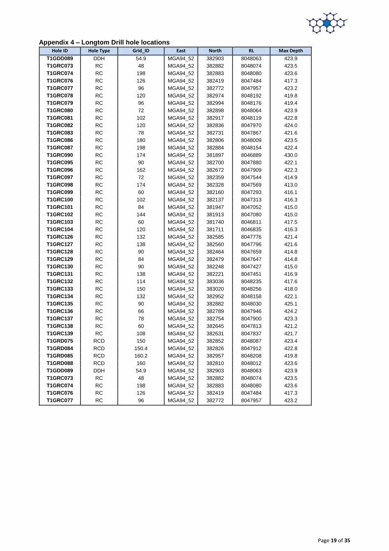
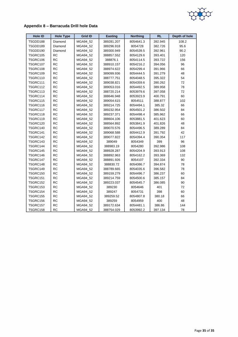
21 diamond drill holes for 2,940.5 m and 18 RC drill holes for 2,154 m and 9 RC precollar diamond tail (RD) holes for 1,369.3 m completed at the Emperor deposit. Hole locations tabulated in an Appendix to this announcement report.
Data aggregation methods
In reporting Exploration Results, weighting averaging techniques, maximum and/or minimum grade truncations (e.g. cutting of high grades) and cut-off grades are usually Material and should be stated.
Data compiled in Excel and validated in Datashed by an external data management consultancy.
RC samples were all 1 m in length, diamond core samples vary between 1m and 2 m samples.
Metal equivalents are not reported as this is an industrial mineral project where the mineral properties define grade (e.g. flake size and purity).
A nominal 3% Total Graphitic Carbon cut-off has been applied in the determination of significant intercepts
Relationship between mineralisation widths and intercept lengths
If the geometry of the mineralisation with respect to the drillhole angle is known, its nature should be reported.
If it is not known and only the down hole lengths are reported, there
Mineralised widths at Emperor are estimated to be typically between 5 m and 70 m, compared with RC samples of 1m width. There is a very close relationship between the graphitic schist unit and Total Graphitic Carbon (TGC%) assays. The presence of graphitic schist is clearly evident in
Page 8 of 35
should be a clear statement to this effect.
both the RC chips and diamond drill core so that the assay widths can be clearly related to the geological logs.
The graphitic schist horizon has been interpreted as an anticlinal fold. Angled drill holes (generally 60o) have targeted the mineralised unit with the priority to intersect the limbs perpendicular to the strike of the graphitic schist horizon, although in some areas this was not possible and holes were drilled down dip. However interpreted EM data and the width of intersections where holes were drilled perpendicular to the unit have allowed for a good indication of unit thickness to be made and applied in areas where the information is not available.
Diagrams Appropriate maps and sections (with scales) and tabulations of intercepts should be included for any significant discovery being reported These should include, but not be limited to a plan view of drillhole collar locations and appropriate sectional views.
Not relevant as Mineral Resource being reported.
Balanced reporting
Where comprehensive reporting of all Exploration Results is not practicable, representative reporting of both low and high grades and/or widths should be practiced to avoid misleading reporting of Exploration Results.
Exploration results are not being reported for the Mineral Resources area.
Other substantive exploration data
Other exploration data, if meaningful and material, should be reported including (but not limited to): geological observations; geophysical survey results; geochemical survey results; bulk samples – size and method of treatment; metallurgical test results; bulk density, groundwater, geotechnical and rock characteristics; potential deleterious or contaminating substances.
The September 2014 VTEM Supermax survey over the McIntosh Flake Graphite Project covered a total of 642 line kilometres and identified a total of 12 high-priority anomalies. Five of these were previously identified by induced polarisation (IP) and historical electromagnetic (EM) techniques and confirmed to be flake graphite schist by geological field mapping, petrographic analysis, rock chip sampling and exploration drilling.
VTEM geophysical work was carried out by Geotech Limited with the data validated and processed by Southern Geoscience Consultants (SGC).
Further work The nature and scale of planned further work (e.g. tests for lateral extensions or depth extensions or large-scale step-out drilling).
Further diamond core drilling has been recommended to twin and verify existing RC holes at Emperor. This core is planned to be assayed for TGC and examined petrographically to assess graphite flake characteristics.
Additional dry density work on core to be carried out on mineralised and background domains.
Estimate S% content into resource model
Program to assess moisture content of Emperor material.
Multi-element analysis of mineralisation and waste material
Section 3 Estimation and Reporting of Mineral Resources
Criteria JORC Code explanation Commentary
Database integrity
Measures taken to ensure that data has not been corrupted by, for example, transcription or keying errors, between its initial collection and its use for Mineral Resource estimation purposes.
Data validation procedures used.
Primary data was captured into spreadsheet format by the supervising geologist, validated and subsequently loaded into Hexagon’s database.
Database extracted as an .mdb access file from Datashed and validated before importing into Surpac.
Additional data validation by Optiro; included checking for out of range assay data and overlapping or missing intervals.
Site Visits Comment on any site visits undertaken by the Competent Person and the outcome of those visits.
Numerous site visits were completed by S. Tomlinson during the 2015 and 2016 drilling period. The diamond and RC drill rigs were inspected, sampling procedures checked, RC chips and diamond core logged.
Geological interpretation
Confidence in (or conversely, the uncertainty of) the geological interpretation of the mineral deposit.
Nature of the data used and of any assumptions made.
The effect, if any, of alternative interpretations on Mineral Resource estimation.
The use of geology in guiding and controlling Mineral Resource estimation.
The factors affecting continuity both of grade and geology.
Geological interpretation based on lithology logging, structural logging, geochemical sampling, prospect scale surface mapping and modelled VTEM data collected during the 2014 VTEM Supermax survey.
Drill coverage to ~40 m by 40 m.
Mineralisation wireframe produced based on soft 3% TGC cut-off grade delineating ore/waste boundary. Internal dilution in the main mineralised envelope has been modelled as two domains. Further modelling of mafic intrusive bodies have also been modelled.
The base of oxidation and mafic intrusives were also modelled as part of the Emperor resource.
Confidence in the grade and geological continuity is reflected in the Mineral Resource classification.
Page 9 of 35
Dimensions The extent and variability of the Mineral Resource expressed as length (along strike or otherwise), plan width, and depth below surface to the upper and lower limits of the Mineral Resource.
The Emperor resource extends 480 m north-northwest to south-southeast. The mineralisation occurs within an anticline of the hosting graphite schist units ranging in thickness between 5 m and 70 m.
Mineralisation is open along strike and at depth along the fold limbs.
Estimation and modelling techniques
The nature and appropriateness of the estimation technique(s) applied and key assumptions, including treatment of extreme grade values, domaining, interpolation parameters and maximum distance of extrapolation from data points. If a computer assisted estimation method was chosen include a description of computer software and parameters used.
The availability of check estimates, previous estimates and/or mine production records and whether the Mineral Resource estimate takes appropriate account of such data.
The assumptions made regarding recovery of by-products.
Estimation of deleterious elements or other non-grade variables of economic significance (e.g. sulphur for acid mine drainage characterisation).
In the case of block model interpolation, the block size in relation to the average sample spacing and the search employed.
Any assumptions behind modelling of selective mining units.
Any assumptions about correlation between variables.
Description of how the geological interpretation was used to control the resource estimates.
Discussion of basis for using or not using grade cutting or capping.
The process of validation, the checking process used, the comparison of model data to drillhole data, and use of reconciliation data if available.
The resource was modelled using Geovia’s Surpac v6.7 modelling software.
Drill hole sample data was flagged from interpretations of the top and base of the mineralisation horizon.
Samples were composited to 1 m down hole length.
Top grade cuts were not required (low coefficient of variation and no outlier grades)
Statistical analysis was completed to investigate low correlation variances, boundary conditions between domains, and fresh/oxide.
TGC mineralisation continuity was interpreted from variogram analyses to have a horizontal range of 170 m (north-west to south-east).
The maximum extrapolation distance is 20 m along strike and 20 m across strike.
Grade estimation was into parent blocks of 40 mE by 20 mN by 5 mRL. Block size was selected based on kriging neighbourhood analysis.
Total Graphitic Carbon (TGC) estimated by Ordinary Kriging (OK) for mineralised domains (1 to 4) at the parent block scale.
The search ellipses were oriented within the plane of the mineralisation.
Three estimation passes were used; the first search was based upon the variogram ranges in the three principal directions; the second search was two times the initial search and the third search was four times the initial search, with reduced sample numbers required for estimation.
Aproximately70% of the block grades were estimated in the first pass for domain 1 (main envelope) and 49% for domain 4.
The estimated TGC block model grades were visually validated against the input drillhole data, comparisons were carried out against the drillhole data and by northing, easting and elevation slices.
There is no production data and so no reconciliation has taken place.
Sulphur will be estimated into the model, as sulphide minerals have the potential to affect metallurgical processes for recovering graphite. The available metallurgical testwork results indicate that the sulphide minerals do not present any issues in recovering graphite. Sulphur is not correlated with TGC.
Moisture Whether the tonnages are estimated on a dry basis or with natural moisture, and the method of determination of the moisture content.
The Emperor deposit is above the water table. Down hole dipping during the 2015 field season did not intercept water.
Moisture content has not been tested
Cut-off parameters
The basis of the adopted cut-off grade(s) or quality parameters applied.
The Mineral Resource is reported above a 3% TGC cut-off grade to reflect current commodity prices and open pit mining methods.
Mining factors or assumptions
Assumptions made regarding possible mining methods, minimum mining dimensions and internal (or, if applicable, external) mining dilution. It is always necessary as part of the process of determining reasonable prospects for eventual economic extraction to consider potential mining methods, but the assumptions made regarding mining methods and parameters when estimating Mineral Resources may not always be rigorous.
It is assumed that extraction will be by open pit mining and that the mineralisation is economic to exploit to currently modelled depths.
Mining factors such as dilution and ore loss have not been applied.
No assumptions about minimum mining widths or dilution have been made.
Metallurgical factors or assumptions
The basis for assumptions or predictions regarding metallurgical amenability. It is always necessary as part of the process of determining reasonable prospects for eventual economic extraction to consider potential metallurgical methods, but
A 99% graphite concentrate was produced from a process of crushing and grinding material from the McIntosh project. See results in metallurgical test work conducted by ALS Global in Adelaide. Refer to announcement released 18 January 2016.
Metallurgical testwork on Emperor material shows that the sulphides present are easily liberated from the graphite by flotation.
Page 10 of 35
the assumptions regarding metallurgical treatment processes and parameters made when reporting Mineral Resources may not always be rigorous.
The results from metallurgical testwork have been considered for Mineral Resource classification.
Environmental factors or assumptions
Assumptions made regarding possible waste and process residue disposal options. It is always necessary as part of the process of determining reasonable prospects for eventual economic extraction to consider the potential environmental impacts of the mining and processing operation.
No assumptions have been made regarding waste and process residue
Environmental studies are being completed as part of the McIntosh Pre-Feasibility study.
Bulk density Whether assumed or determined. If assumed, the basis for the assumptions. If determined, the method used, whether wet or dry, the frequency of the measurements, the nature, size and representativeness of the samples.
The bulk density for bulk material must have been measured by methods that adequately account for void spaces (vugs, porosity, etc), moisture and differences between rock and alteration zones within the deposit.
Discuss assumptions for bulk density estimates used in the evaluation process of the different materials.
Dry density was assigned a value of 2.85 t/m3 (fresh) and 2.65 t/m3 (oxide) based on 25 dried core samples and water emersion technique carried out by SGS.
Geophysical gamma density data was also obtained but has not been included in the resource.
Classification The basis for the classification of the Mineral Resources into varying confidence categories.
Whether appropriate account has been taken of all relevant factors (i.e. relative confidence in tonnage/grade estimations, reliability of input data, confidence in continuity of geology and metal values, quality, quantity and distribution of the data).
Whether the result appropriately reflects the Competent Person’s view of the deposit.
Mineral Resources have been classified on the basis of confidence in geological and grade continuity using the drilling density, geological model, modelled grade continuity and conditional bias measures (slope of the regression and kriging efficiency) as criteria.
The results from metallurgical testwork have been considered for Mineral Resource classification. The likelihood of eventual economic extraction was considered in terms of possible open pit mining, likely product specifications and possible product marketability.
Measured Mineral Resources - none defined.
Indicated resources have been defined in the centre of the deposit where material was estimated in the first pass estimation. Drill spacing for indicated material is generally 40 m by 40 m.
Inferred material occurs in the northern and southern limits of the deposit where drilling data is sparser (to 40 m by 80 m), but still sufficient to assume continuity of mineralisation. Confidence for the resource in these areas is also from the VTEM survey completed over the area.
The classification considers all available data and quality of the estimate and reflects the Competent Person’s view of the deposit.
Audits or reviews
The results of any audits or reviews of Mineral Resource estimates.
CSA carried out a site visit in 2015.
Discussion of relative accuracy/ confidence
Where appropriate a statement of the relative accuracy and confidence level in the Mineral Resource estimate using an approach or procedure deemed appropriate by the Competent Person.
The statement should specify whether it relates to global or local estimates, and, if local, state the relevant tonnages, which should be relevant to technical and economic evaluation.
The relative accuracy of the Mineral Resource estimate is reflected in the reporting of the Mineral Resource as per the guidelines of the JORC Code (2012 Edition).
The Mineral Resource is a global estimate of tonnes and grade.
Relative tonnages and grade above the nominated cut-off grades for TGC are provided in this announcement. Volumes of the collated blocks sub-set by mineralisation domains were multiplied by the dry density value to derive the tonnages. The contained graphite values were calculated by multiplying the TGC grades (%) by the estimated tonnage.
No production data is available to reconcile results with.
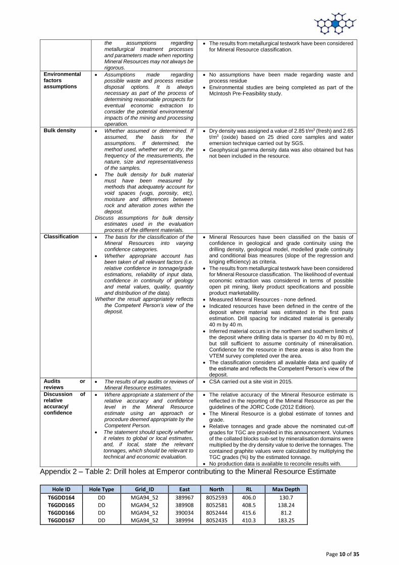
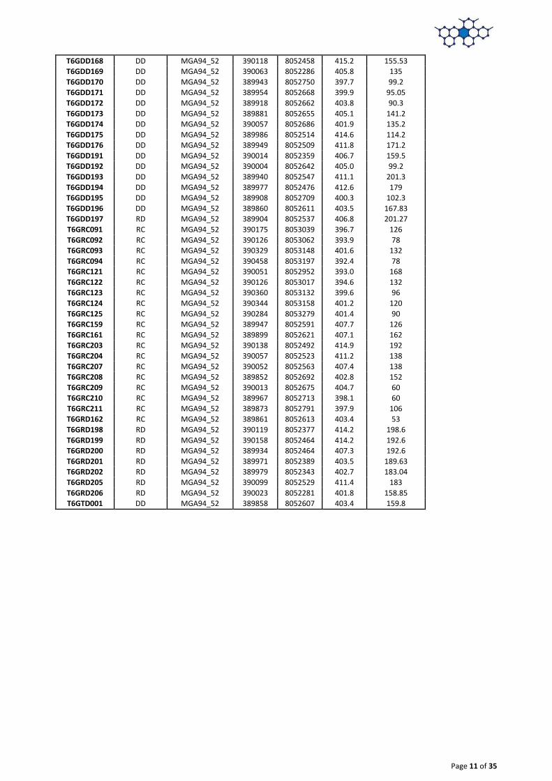
Appendix 2 – Table 2: Drill holes at Emperor contributing to the Mineral Resource Estimate
Hole ID Hole Type Grid_ID East North RL Max Depth
T6GDD164 DD MGA94_52 389967 8052593 406.0 130.7
T6GDD165 DD MGA94_52 389908 8052581 408.5 138.24
T6GDD166 DD MGA94_52 390034 8052444 415.6 81.2
T6GDD167 DD MGA94_52 389994 8052435 410.3 183.25
Page 11 of 35
T6GDD168 DD MGA94_52 390118 8052458 415.2 155.53
T6GDD169 DD MGA94_52 390063 8052286 405.8 135
T6GDD170 DD MGA94_52 389943 8052750 397.7 99.2
T6GDD171 DD MGA94_52 389954 8052668 399.9 95.05
T6GDD172 DD MGA94_52 389918 8052662 403.8 90.3
T6GDD173 DD MGA94_52 389881 8052655 405.1 141.2
T6GDD174 DD MGA94_52 390057 8052686 401.9 135.2
T6GDD175 DD MGA94_52 389986 8052514 414.6 114.2
T6GDD176 DD MGA94_52 389949 8052509 411.8 171.2
T6GDD191 DD MGA94_52 390014 8052359 406.7 159.5
T6GDD192 DD MGA94_52 390004 8052642 405.0 99.2
T6GDD193 DD MGA94_52 389940 8052547 411.1 201.3
T6GDD194 DD MGA94_52 389977 8052476 412.6 179
T6GDD195 DD MGA94_52 389908 8052709 400.3 102.3
T6GDD196 DD MGA94_52 389860 8052611 403.5 167.83
T6GDD197 RD MGA94_52 389904 8052537 406.8 201.27
T6GRC091 RC MGA94_52 390175 8053039 396.7 126
T6GRC092 RC MGA94_52 390126 8053062 393.9 78
T6GRC093 RC MGA94_52 390329 8053148 401.6 132
T6GRC094 RC MGA94_52 390458 8053197 392.4 78
T6GRC121 RC MGA94_52 390051 8052952 393.0 168
T6GRC122 RC MGA94_52 390126 8053017 394.6 132
T6GRC123 RC MGA94_52 390360 8053132 399.6 96
T6GRC124 RC MGA94_52 390344 8053158 401.2 120
T6GRC125 RC MGA94_52 390284 8053279 401.4 90
T6GRC159 RC MGA94_52 389947 8052591 407.7 126
T6GRC161 RC MGA94_52 389899 8052621 407.1 162
T6GRC203 RC MGA94_52 390138 8052492 414.9 192
T6GRC204 RC MGA94_52 390057 8052523 411.2 138
T6GRC207 RC MGA94_52 390052 8052563 407.4 138
T6GRC208 RC MGA94_52 389852 8052692 402.8 152
T6GRC209 RC MGA94_52 390013 8052675 404.7 60
T6GRC210 RC MGA94_52 389967 8052713 398.1 60
T6GRC211 RC MGA94_52 389873 8052791 397.9 106
T6GRD162 RC MGA94_52 389861 8052613 403.4 53
T6GRD198 RD MGA94_52 390119 8052377 414.2 198.6
T6GRD199 RD MGA94_52 390158 8052464 414.2 192.6
T6GRD200 RD MGA94_52 389934 8052464 407.3 192.6
T6GRD201 RD MGA94_52 389971 8052389 403.5 189.63
T6GRD202 RD MGA94_52 389979 8052343 402.7 183.04
T6GRD205 RD MGA94_52 390099 8052529 411.4 183
T6GRD206 RD MGA94_52 390023 8052281 401.8 158.85
T6GTD001 DD MGA94_52 389858 8052607 403.4 159.8
Page 12 of 35
Appendix 3 - JORC Table 1 Longtom Resource
Section 1 Sampling Techniques and Data Criteria JORC Code Explanation Commentary
Sampling techniques
Nature and quality of sampling
Include reference to measures taken to ensure sample representivity and the appropriate calibration of any measurement tools or systems used.
1. Reverse Circulation
RC drilling used high pressure air and a cyclone with a rotary splitter.
Samples were collected at one-metre intervals.
Approximately 54% of samples were not submitted for assay due to the visual non-mineralised nature of the material collected. All graphitic intervals were submitted for analyses.
Duplicate and standards analysis were completed and no issues identified with sampling reliability.
Samples were sent to the ALS laboratory in Perth for assay preparation and then sent to ALS in Brisbane for Total Graphitic Carbon (TGC) analyses.
All samples were pulverised to better than 85% passing 75μm with a 10g aliquot taken for assay.
Sampling was guided by Hexagon’s protocols and QA/QC procedures.
RC drilling samples of 3 to 5 kg weight were shipped to the laboratory in plastic bags; samples were pulverised and milled for assay.
2. Diamond Drilling
Drill samples in this program were collected based on geology, varying in thickness from 0.1 m to 2 m intervals. Sampling was completed so samples could be composited to one metre intervals within the geological units.
Core samples were quarter split HQ3 core using a diamond bladed saw and sent to the ALS laboratory in Perth for assay preparation and then sent to ALS in Brisbane for Total Graphitic Carbon (TGC) analyses.
All samples were pulverised to better than 85% passing 75μm with a 10 g aliquot taken for assay.
Duplicate samples, CRM standards and blank material were used during the drill programs. Sampling was guided by Hexagon’s protocols and QA/QC procedures.
Drilling Techniques
Drill type (e.g. core, reverse circulation, open-hole hammer, rotary air blast, auger, Bangka, sonic, etc) and details (e.g. core diameter, triple or standard tube, depth of diamond tails, face-sampling bit or other type, whether core is oriented and if so, by what method, etc).
1. Reverse Circulation
RC drill holes (total of 4,146 m from 37 holes) – completed with face sampling hammers and collected through a cyclone. Sample recovery was estimated at a percentage of the expected sample, sample state recorded (dry, moist or wet), samples tested with 10:1 HCl acid for carbonates and graphite surface float.
RC drilling was completed by Egan drilling using an X400 drill rig.
2. Diamond Drilling
Diamond drill holes (total of 54.9 m for 1 hole) – collected HQ3 core using a 6m core barrel and drilled by Mt Magnet Drilling using a truck mounted modified Mole top drive diamond rig. Core orientation was recorded using a Reflex EZ Shot instrument.
RC pre-collars were drilled with HQ3 diamond tails for a total of 620.6 m from 4 holes.
Drill sample recovery
Method of recording and assessing core and chip sample recoveries and results assessed.
Measures taken to maximise sample recovery and ensure representative nature of the samples.
Whether a relationship exists between sample recovery and grade and whether sample bias may have occurred due to preferential loss/gain of fine/coarse material.
3. RC Drilling
A face sampling hammer was used to reduce contamination at the face.
1 m drill chip samples, weighing approximately 2kg were collected throughout the drill programme in sequentially numbered bags.
Split samples were recovered from a cyclone and rig-mounted cone splitter. The sample recovery and physical state were recorded.
Every interval drilled is represented in an industry standard chip tray that provides a check for sample continuity down hole.
4. Diamond drilling
Core recovery was excellent. Recoveries were measured for each run between core blocks and measurements recorded. Core was photographed and logged for RQD and geology.
Analysis from one pair of twin holes drilled at the resource noted a lower graphite content in the RC samples when compared with diamond core. Insufficient work has been completed on comparing RC and diamond methods to rule out drilling by RC.
Page 13 of 35
Logging Whether core and chip samples have been geologically and geotechnically logged to a level of detail to support appropriate Mineral Resource estimation, mining studies and metallurgical studies.
Whether logging is qualitative or quantitative in nature. Core (or costean, channel, etc) photography.
The total length and percentage of the relevant intersections logged.
All RC and diamond drilling was logged for geology in the field by qualified geologists. Lithological and mineralogical data was recorded for all drill holes using a coding system developed specifically for the Project. Primary and secondary lithologies are recorded in addition to texture, structure, colour, grain size, alteration type and intensity, estimates of mineral quantities, graphite intensity and sample recovery. The oxidation zone is also recorded.
No adjustments have been made to any assay data
Geological logging is qualitative in nature.
Diamond drilling logging also recorded recovery, structure and geotechnical data.
Diamond core was orientated using the Reflex orientation tool.
Core was photographed both dry and wet. Sub-sample techniques and sample preparation
If non-core, whether riffled, tube sampled, rotary split, etc and whether sampled wet or dry.
For all sample types, the nature, quality and appropriateness of the sample preparation technique.
Quality control procedures adopted for all sub-sampling stages to maximise representivity of samples.
Measures taken to ensure that the sampling is representative of the in situ material collected, including for instance results for field duplicate/second-half sampling.
Whether sample sizes are appropriate to the grain size of the material being sampled.
1. RC Drilling
All samples marked with unique sequential sample number
RC drilling samples were bagged at the drill site in calico bags with a second outer plastic bag to prevent loss of fines. The sample sizes are considered to be appropriate to the grain size of the material being sampled.
1m RC drilling samples were submitted to either ALS laboratories in Brisbane. The samples were riffle split on a 50:50 basis, with one split pulverised and analysed for Total Graphitic Carbon (TGC), Total Carbon (TC) and Total Sulphur (TS) using a LECO Furnace, and the other split held in storage.
For RC samples, standards and field duplicates were inserted at an approximate rate of 1 in every 20 samples collected. Duplicate assay results exhibit good correlation with the original assays and no consistent bias is evident.
Sample preparation: 1. Coarse crush using a jaw crushed to better than 70%
passing 6mm. 2. For samples exceeding 3 kg received mass, riffle split
using a Jones Riffle Splitter 50:50 3. Pulverise up to 3 kg of coarse crushed material to better
than 85% passing 75µm particle size 4. Small aliquot (~10g) taken for assay.
2. Diamond Drilling
Diamond drill core was cut into half core (used for metallurgical testing) and the remaining half sawn into quarter core using diamond blade core-saw. Quarter core was used for samples and duplicates. A small number of samples were also sent to Actlabs in Canada for analysis.
Duplicate assay results exhibit good correlation with the original assays and no consistent bias is evident.
Sample preparation: 1. Coarse crush using a jaw crushed to better than 70%
passing 6mm. 2. For samples exceeding 3kg received mass, riffle split
using a Jones Riffle Splitter 50:50 3. Pulverise up to 3 kg of coarse crushed material to better
than 85% passing 75µm particle size 4. Small aliquot (~10 g) taken for assay.
Sampling procedures and sample preparation represent industry good practice:
Quality of assay data and laboratory tests
The nature, quality and appropriateness of the assaying and laboratory procedures used and whether the technique is considered partial or total.
Nature of quality control procedures adopted (e.g. standards, blanks, duplicates, external laboratory checks) and whether acceptable levels of accuracy (i.e. lack of bias) and precision have been established.
The assaying and laboratory procedures used are industry standard and are appropriate for the material tested.
Sampling was guided by Hexagon’s protocols and QA/QC procedures.
For RC samples, standards and field duplicates were inserted at an approximate rate of 1 in every 20 samples collected.
Field duplicates were inserted into diamond core samples at a rate of 4 every 100 samples, standards at a rate of 4 every 100 samples and blanks at 2 every 100 samples.
Statistical analysis of standards, blanks and duplicates during the QAQC process showed that the data was satisfactory.
No issues were identified with sampling reliability Verification of sampling and assaying
The verification of significant intersections by either independent or alternative company personnel.
The use of twinned holes.
Documentation of primary data, data
Hexagon QA/QC checks show that all samples are within acceptable limits. No adjustments to assay data have been made based on the analysis of duplicates, standards and blanks.
Standards from ALS laboratory were found to be acceptable.
Page 14 of 35
entry procedures, data verification, data storage (physical and electronic) protocols.
Discuss any adjustment to assay data.
Duplicate analysis was completed and no sampling issues were identified.
Analysis from one pair of twin holes drilled at Hexagon’s Longtom resource noted a lower graphite content in the RC samples when compared with diamond core. It is suggested that RC samples are biased due to the loss of fine material.
The Hexagon database is hosted in a SQL backend database, ensuring that data is validated as it is captured and exports are produced regularly. Assay results are merged into the database from the lab certificates limiting transcription or mapping errors from occurring.
No adjustments have been made to the results.
Location of Data points
Accuracy and quality of surveys used to locate drillholes (collar and down-hole surveys), trenches, mine workings and other locations used in Mineral Resource estimation.
Specification of the grid system used.
Quality and adequacy of topographic control.
All drill hole collars were surveyed using Differential GPS by a registered surveyor. The degree of accuracy of drill hole collar location and RL is estimated to be within 0.1m for DGPS.
Downhole surveys were taken at the end of drilling the hole using EZshot and EZTrac cameras
Topographic control was adequate for the purposes of Mineral Resource estimation.
The map projection used is the Australia Geodetic MGA 94 Zone 52.
Data spacing and distribution
Data spacing for reporting of Exploration Results.
Whether the data spacing and distribution is sufficient to establish the degree of geological and grade continuity appropriate for the Mineral Resource and Ore Reserve estimation procedure(s) and classifications applied.
Whether sample compositing has been applied.
Drill spacing on an approximate 40 m by 80 m grid throughout the majority of the deposit.
Geological interpretation and mineralisation continuity analysis indicates that data spacing is sufficient for definition of a Mineral Resource.
Orientation of data in relation to geological structure
Whether the orientation of sampling achieves unbiased sampling of possible structures and the extent to which this is known, considering the deposit type.
If the relationship between the drilling orientation and the orientation of key mineralised structures is considered to have introduced a sampling bias, this should be assessed and reported if material.
Holes generally drilled dipping at -60° perpendicular to the target graphitic schist unit at an orientation of 140o.
Diamond drill core has been orientated using a Reflex ACE tool 9Act II), with α and β angles measured and positioned using a Kenometer. MapInfo software was used to calculate dip and dip direction for each structure.
The relationship between the drilling orientation and the orientation of key mineralised structures is not considered to have introduced a sampling bias.
Sample Security The measures taken to ensure sample security.
Unique sample number was retained during the whole process
RC and diamond samples were placed into calico bags and then into self-sealing plastic bags prior to being put into bulka bags. The bulka bags were then transported by road. RC samples were sent to the ALS laboratory in Brisbane for preparation and analysis and diamond core samples were sent to Actlabs in Canada for analysis.
The sample security is considered to be adequate.
Audits or reviews
The results of any audits or reviews of sampling techniques and data.
Field data is managed by an independent data management consultancy Rocksolid Solutions.
All data collected was subject to internal review
Section 2 Reporting of Exploration Results
Criteria JORC Code explanation Commentary
Mineral tenement and land tenure status
Type, reference name/number, location and ownership including agreements or material issues with third parties such as joint ventures, partnerships, overriding royalties, native title interests, historical sites, wilderness or national park and environmental settings.
The security of the tenure held at the time of reporting along with any known impediments to obtaining a licence to operate in the area.
Drilling at the Longtom deposit occurred on exploration lease E80/3928. This tenement is held by McKintosh Resources Pty Ltd who is a wholly owned subsidiary of Hexagon Resources. Hexagon Resources are the managers of exploration on the project.
Exploration done by other parties
Acknowledgment and appraisal of exploration by other parties.
The East Kimberley has been largely explored for base metals and diamonds with no active previous exploration for graphite. Graphite had been noted by Gemutz during regional mapping in the Mabel Downs area for the BMR in 1967, by Rugless mapping and RAB drilling in the vicinity of
Page 15 of 35
Melon Patch bore, to the east of the Great Northern Highway in 1993 and has been located during nickel exploration by Australian Anglo American Ltd, Panoramic Resources Ltd and Thundelarra Resources Ltd over the last 20 years.
Geology Deposit type, geological setting and style of mineralisation.
The McIntosh Project graphite schist horizons occur in the high grade terrain of the Halls Creek Mobile Zone of Western Australia. The host stratigraphy is the Tickalara Metamorphic which extend for approximately 130 km along the western side of the major Halls Creek Fault. The metamorphic rocks reach granulite metamorphic facies under conditions of high-temperature and high pressure although the metamorphic grade in the McIntosh Project area appears to be largely upper amphibolite facies with the presence of key minerals such as sillimanite and evidence of original cordierite.
Hexagon has identified potential graphite schist horizons based on GSWA mapping and EM anomalism over a strike length in excess of 15 km within the project area, with potential for an additional 35 km strike length of graphite bearing material from lower order EM anomalism.
Drill hole Information
A summary of all information material to the understanding of the exploration results including a tabulation of the following information for all Material drillholes:
easting and northing of the drillhole collar
elevation or RL (elevation above sea level in metres) of the drillhole collar
dip and azimuth of the hole
down hole length and interception depth
hole length.
1 diamond drill hole for 54.9 m, 37 RC drill holes for 4,146 m and 4 RC precollar diamond tail (RD) holes for 620.6 m completed at the Longtom deposit. Hole locations tabulated and reported in the body of the report.
Data aggregation methods
In reporting Exploration Results, weighting averaging techniques, maximum and/or minimum grade truncations (e.g. cutting of high grades) and cut-off grades are usually Material and should be stated.
Data compiled in Excel and validated in Datashed by an external data management consultancy.
RC samples were all 1 m in length, diamond core samples vary between 1 m and 2 m samples.
Metal equivalents are not reported as this is an industrial mineral project where the mineral properties define grade (e.g. flake size and purity).
A nominal 3% Total Graphitic Carbon cut-off has been applied in the determination of significant intercepts
Relationship between mineralisation widths and intercept lengths
If the geometry of the mineralisation with respect to the drillhole angle is known, its nature should be reported.
If it is not known and only the down hole lengths are reported, there should be a clear statement to this effect.
Mineralised widths at Longtom are estimated to be typically 25 m, compared with RC samples of 1 m width. There is a very close relationship between the graphitic schist unit and Total Graphitic Carbon (TGC%) assays. The presence of graphitic schist is clearly evident in both the RC chips and diamond drill core so that the assay widths can be clearly related to the geological logs.
The graphitic schist horizon has been interpreted as a steeply dipping unity with thin bands of internal waste. Angled drill holes (generally 60o) have targeted the mineralised unit with the priority to intersect the graphitic schist unit. The interpreted EM data has also allowed for a good indication of unit thickness to be made and applied in areas where the information is not available.
Diagrams Appropriate maps and sections (with scales) and tabulations of intercepts should be included for any significant discovery being reported These should include, but not be limited to a plan view of drillhole collar locations and appropriate sectional views.
Not relevant as Mineral Resource being reported.
Balanced reporting
Where comprehensive reporting of all Exploration Results is not practicable, representative reporting of both low and high grades and/or widths should be practiced to avoid misleading reporting of Exploration Results.
Exploration results are not being reported for the Mineral Resources area.
Other substantive exploration data
Other exploration data, if meaningful and material, should be reported including (but not limited to): geological observations; geophysical survey results; geochemical survey results; bulk samples – size and method of treatment; metallurgical
The September 2014 VTEM Supermax survey over the McIntosh Flake Graphite Project covered a total of 642 line kilometres and identified a total of 12 high-priority anomalies. Five of these were previously identified by induced polarisation (IP) and historical electromagnetic (EM) techniques and confirmed to be flake graphite schist by
Page 16 of 35
test results; bulk density, groundwater, geotechnical and rock characteristics; potential deleterious or contaminating substances.
geological field mapping, petrographic analysis, rock chip sampling and exploration drilling.
VTEM geophysical work was carried out by Geotech Limited with the data validated and processed by Southern Geoscience Consultants (SGC).
Further work The nature and scale of planned further work (e.g. tests for lateral extensions or depth extensions or large-scale step-out drilling).
Further RC drilling to improve domaining and increase the definition of the internal dilution is required. The increase in drilling data would also allow for an increase in confidence in the resource model and subsequently a resource upgrade.
Test EM anomalies along strike for graphite mineralisation potential.
Additional dry density work on core to be carried out on mineralised and background domains.
Estimate S% content into resource model
Program to assess moisture content of Longtom material.
Section 3 Estimation and Reporting of Mineral Resources
Criteria JORC Code explanation Commentary
Database integrity
Measures taken to ensure that data has not been corrupted by, for example, transcription or keying errors, between its initial collection and its use for Mineral Resource estimation purposes.
Data validation procedures used.
Primary data was captured into spreadsheet format by the supervising geologist, validated and subsequently loaded into Hexagon’s database.
Database extracted as an .mdb access file from Datashed and validated before importing into Surpac.
Additional data validation by Optiro; included checking for out of range assay data and overlapping or missing intervals.
Site Visits Comment on any site visits undertaken by the Competent Person and the outcome of those visits.
Drilling data collected for the Longtom resource was completed by previous Lamboo / Hexagon Employees.
Geological interpretation
Confidence in (or conversely, the uncertainty of) the geological interpretation of the mineral deposit.
Nature of the data used and of any assumptions made.
The effect, if any, of alternative interpretations on Mineral Resource estimation.
The use of geology in guiding and controlling Mineral Resource estimation.
The factors affecting continuity both of grade and geology.
Geological interpretation based on lithology logging, structural logging, geochemical sampling, prospect scale surface mapping and modelled VTEM data collected during the 2014 VTEM Supermax survey.
Drill coverage to ~40 m by 80 m.
Mineralisation wireframe produced based on soft 3% TGC cut-off grade delineating ore/waste boundary. Internal dilution in the main mineralised envelope has been modelled.
The base of oxidation is also modelled as part of the Longtom resource.
Confidence in the grade and geological continuity is reflected in the Mineral Resource classification.
Dimensions The extent and variability of the Mineral Resource expressed as length (along strike or otherwise), plan width, and depth below surface to the upper and lower limits of the Mineral Resource.
The Longtom resource extends approximately 800 m north-east to south-west. The mineralisation follows steeply dipping unit of the hosting graphite schist unit and has a width of approximately 25 m.
Mineralisation is open along strike and at depth.
Estimation and modelling techniques
The nature and appropriateness of the estimation technique(s) applied and key assumptions, including treatment of extreme grade values, domaining, interpolation parameters and maximum distance of extrapolation from data points. If a computer assisted estimation method was chosen include a description of computer software and parameters used.
The availability of check estimates, previous estimates and/or mine production records and whether the Mineral Resource estimate takes appropriate account of such data.
The assumptions made regarding recovery of by-products.
Estimation of deleterious elements or other non-grade variables of economic significance (e.g. sulphur for acid mine drainage characterisation).
In the case of block model interpolation, the block size in relation to the average sample spacing and the search employed.
Any assumptions behind modelling of
The resource was modelled using Geovia’s Surpac v6.7 modelling software.
Drill hole sample data was flagged from interpretations of the top and base of the mineralisation horizon.
Samples were composited to 1 m down hole length.
Top grade cuts were not required (low coefficient of variation and no outlier grades)
Statistical analysis was completed to investigate low correlation variances, boundary conditions between domains, and fresh/oxide.
TGC mineralisation continuity was interpreted from variogram analyses to have a horizontal range of 140 m (north-east to south-west).
The maximum extrapolation distance is 140 m along strike and 108 m down dip. The interpreted EM plates show that mineralisation extends in these areas.
Grade estimation was into parent blocks of 40 mE by 10 mN by 5 mRL. Block size was selected based on kriging neighbourhood analysis.
Estimation of TGC was carried out using ordinary kriging at the parent block scale.
The search ellipses were oriented within the plane of the mineralisation.
Two estimation passes were used; the first search was based upon the variogram ranges in the three principal directions; the second search was two times the initial search.
Page 17 of 35
selective mining units.
Any assumptions about correlation between variables.
Description of how the geological interpretation was used to control the resource estimates.
Discussion of basis for using or not using grade cutting or capping.
The process of validation, the checking process used, the comparison of model data to drillhole data, and use of reconciliation data if available.
Approximately 95% of the block grades were estimated in the first pass.
The estimated TGC block model grades were visually validated against the input drillhole data, comparisons were carried out against the drillhole data and by northing, easting and elevation slices.
There is no production data and so no reconciliation has taken place.
Sulphur will be estimated into the model, as sulphide minerals have the potential to affect metallurgical processes for recovering graphite. The available metallurgical testwork results indicate that the sulphide minerals do not present any issues in recovering graphite. Sulphur is not correlated with TGC.
Moisture Whether the tonnages are estimated on a dry basis or with natural moisture, and the method of determination of the moisture content.
The Longtom deposit is above the water table. Down hole dipping during the 2015 field season did not intercept water.
Moisture content has not been tested
Cut-off parameters
The basis of the adopted cut-off grade(s) or quality parameters applied.
The Mineral Resource is reported above a 3% TGC cut-off grade to reflect current commodity prices and open pit mining methods.
Mining factors or assumptions
Assumptions made regarding possible mining methods, minimum mining dimensions and internal (or, if applicable, external) mining dilution. It is always necessary as part of the process of determining reasonable prospects for eventual economic extraction to consider potential mining methods, but the assumptions made regarding mining methods and parameters when estimating Mineral Resources may not always be rigorous.
It is assumed that extraction will be by open pit mining and that the mineralisation is economic to exploit to currently modelled depths.
Mining factors such as dilution and ore loss have not been applied.
No assumptions about minimum mining widths or dilution have been made.
Metallurgical factors or assumptions
The basis for assumptions or predictions regarding metallurgical amenability. It is always necessary as part of the process of determining reasonable prospects for eventual economic extraction to consider potential metallurgical methods, but the assumptions regarding metallurgical treatment processes and parameters made when reporting Mineral Resources may not always be rigorous.
A 99% graphite concentrate was produced from a process of crushing and grinding material from the McIntosh project. See results in metallurgical test work conducted by ALS Global in Adelaide. Refer to announcement released 18 January 2016.
Metallurgical test work on material from the nearby (and geologically similar) deposit Emperor shows that the sulphides present are easily liberated from the graphite by flotation.
The results from metallurgical test work have been considered for Mineral Resource classification.
Environmental factors or assumptions
Assumptions made regarding possible waste and process residue disposal options. It is always necessary as part of the process of determining reasonable prospects for eventual economic extraction to consider the potential environmental impacts of the mining and processing operation.
No assumptions have been made regarding waste and process residue
Environmental studies are being completed as part of the McIntosh Pre-Feasibility study.
Bulk density Whether assumed or determined. If assumed, the basis for the assumptions. If determined, the method used, whether wet or dry, the frequency of the measurements, the nature, size and representativeness of the samples.
The bulk density for bulk material must have been measured by methods that adequately account for void spaces (vugs, porosity, etc), moisture and differences between rock and alteration zones within the deposit.
Discuss assumptions for bulk density estimates used in the evaluation process of the different materials.
Dry density was assigned a value of 2.70 t/m3 (fresh) and 2.40 t/m3 (oxide) based on core samples sent to Actlabs and UltraTrace Laboratories for SG test work. Both laboratories used the standard weight in water/weight in air method to estimate the SG.
Classification The basis for the classification of the Mineral Resources into varying confidence categories.
Whether appropriate account has been taken of all relevant factors (i.e.
Mineral Resources have been classified on the basis of confidence in geological and grade continuity using the drilling density, geological model, modelled grade continuity and conditional bias measures (slope of the regression and kriging efficiency) as criteria.
Page 18 of 35
relative confidence in tonnage/grade estimations, reliability of input data, confidence in continuity of geology and metal values, quality, quantity and distribution of the data).
Whether the result appropriately reflects the Competent Person’s view of the deposit.
The results from metallurgical testwork have been considered for Mineral Resource classification. The likelihood of eventual economic extraction was considered in terms of possible open pit mining, likely product specifications and possible product marketability.
Measured Mineral Resources - none defined.
Indicated resources have been defined in the upper portion of the deposit where there is sufficient drill spacing of approximately 25 m by 50 m spacing) to assume continuity of mineralisation between sections. The simple nature of the structure and mineralisation morphology has resulted in a high geological understanding of the deposit with high confidence in the resource which is reflected with the classification.
Inferred material occurs in the lower section of the deposit where drill spacing is approximately 200 m along strike, but still sufficient to assume continuity of mineralisation. Confidence for the resource in these areas is also from the VTEM survey completed over the area.
The classification considers all available data and quality of the estimate and reflects the Competent Person’s view of the deposit.
Audits or reviews
The results of any audits or reviews of Mineral Resource estimates.
The resource estimate has been peer reviewed by independent consultants Optiro
Discussion of relative accuracy/ confidence
Where appropriate a statement of the relative accuracy and confidence level in the Mineral Resource estimate using an approach or procedure deemed appropriate by the Competent Person.
The statement should specify whether it relates to global or local estimates, and, if local, state the relevant tonnages, which should be relevant to technical and economic evaluation.
The relative accuracy of the Mineral Resource estimate is reflected in the reporting of the Mineral Resource as per the guidelines of the JORC Code (2012 Edition).
The mineral resource is a global estimate of tonnes and grade.
Relative tonnages and grade above the nominated cut-off grades for TGC are provided in the body of this report. Volumes of the collated blocks sub-set by mineralisation domains were multiplied by the dry density value to derive the tonnages. The contained graphite values were calculated by multiplying the TGC grades (%) by the estimated tonnage.
No production data is available to reconcile results with.
Page 19 of 35
Appendix 4 – Longtom Drill hole locations
Hole ID Hole Type Grid_ID East North RL Max Depth
T1GDD089 DDH 54.9 MGA94_52 382903 8048063 423.9
T1GRC073 RC 48 MGA94_52 382882 8048074 423.5
T1GRC074 RC 198 MGA94_52 382883 8048080 423.6
T1GRC076 RC 126 MGA94_52 382419 8047484 417.3
T1GRC077 RC 96 MGA94_52 382772 8047957 423.2
T1GRC078 RC 120 MGA94_52 382974 8048192 419.8
T1GRC079 RC 96 MGA94_52 382994 8048176 419.4
T1GRC080 RC 72 MGA94_52 382898 8048064 423.9
T1GRC081 RC 102 MGA94_52 382917 8048119 422.8
T1GRC082 RC 120 MGA94_52 382836 8047970 424.0
T1GRC083 RC 78 MGA94_52 382731 8047867 421.6
T1GRC086 RC 180 MGA94_52 382806 8048009 423.5
T1GRC087 RC 198 MGA94_52 382884 8048154 422.4
T1GRC090 RC 174 MGA94_52 381897 8046889 430.0
T1GRC095 RC 90 MGA94_52 382700 8047880 422.1
T1GRC096 RC 162 MGA94_52 382672 8047909 422.3
T1GRC097 RC 72 MGA94_52 382359 8047544 414.9
T1GRC098 RC 174 MGA94_52 382328 8047569 413.0
T1GRC099 RC 60 MGA94_52 382160 8047293 416.1
T1GRC100 RC 102 MGA94_52 382137 8047313 416.3
T1GRC101 RC 84 MGA94_52 381947 8047052 415.0
T1GRC102 RC 144 MGA94_52 381913 8047080 415.0
T1GRC103 RC 60 MGA94_52 381740 8046811 417.5
T1GRC104 RC 120 MGA94_52 381711 8046835 416.3
T1GRC126 RC 132 MGA94_52 382585 8047776 421.4
T1GRC127 RC 138 MGA94_52 382560 8047796 421.6
T1GRC128 RC 90 MGA94_52 382464 8047659 414.8
T1GRC129 RC 84 MGA94_52 382479 8047647 414.8
T1GRC130 RC 90 MGA94_52 382248 8047427 415.0
T1GRC131 RC 138 MGA94_52 382221 8047451 416.9
T1GRC132 RC 114 MGA94_52 383036 8048235 417.6
T1GRC133 RC 150 MGA94_52 383020 8048256 418.0
T1GRC134 RC 132 MGA94_52 382952 8048158 422.1
T1GRC135 RC 90 MGA94_52 382882 8048030 425.1
T1GRC136 RC 66 MGA94_52 382789 8047946 424.2
T1GRC137 RC 78 MGA94_52 382754 8047900 423.3
T1GRC138 RC 60 MGA94_52 382645 8047813 421.2
T1GRC139 RC 108 MGA94_52 382631 8047837 421.7
T1GRD075 RCD 150 MGA94_52 382852 8048087 423.4
T1GRD084 RCD 150.4 MGA94_52 382826 8047912 422.8
T1GRD085 RCD 160.2 MGA94_52 382957 8048208 419.8
T1GRD088 RCD 160 MGA94_52 382810 8048012 423.6
T1GDD089 DDH 54.9 MGA94_52 382903 8048063 423.9
T1GRC073 RC 48 MGA94_52 382882 8048074 423.5
T1GRC074 RC 198 MGA94_52 382883 8048080 423.6
T1GRC076 RC 126 MGA94_52 382419 8047484 417.3
T1GRC077 RC 96 MGA94_52 382772 8047957 423.2
Page 20 of 35
Appendix 5 – JORC Table 1 Wahoo Resource Estimate
Section 1 Sampling Techniques and Data
Criteria JORC Code Explanation Commentary
Sampling techniques
Nature and quality of sampling
Include reference to measures taken to ensure sample representivity and the appropriate calibration of any measurement tools or systems used.
1. Reverse Circulation
RC drilling used high pressure air and a cyclone with a rotary splitter.
Samples were collected at one-metre intervals.
Approximately 50% of samples were not submitted for assay due to the visual non-mineralised nature of the material collected. All graphitic intervals were submitted for analyses.
Duplicate and standards analysis were completed and no issues identified with sampling reliability.
Samples were sent to the ALS laboratory in Perth for assay preparation and then sent to ALS in Brisbane for Total Graphitic Carbon (TGC) analyses.
All samples were pulverised to better than 85% passing 75μm with a 10 g aliquot taken for assay.
Sampling was guided by Hexagon’s protocols and QA/QC procedures.
RC drilling samples of 3 to 5 kg weight were shipped to the laboratory in plastic bags; samples were pulverised and milled for assay.
2. Diamond Drilling
Drill samples in this program were collected based on geology, varying in thickness from 0.1 m to 2 m intervals. Sampling was completed so samples could be composited to one metre intervals within the geological units.
Core samples were quarter split HQ3 core using a diamond bladed saw and sent to the ALS laboratory in Perth for assay preparation and then sent to ALS in Brisbane for Total Graphitic Carbon (TGC) analyses.
All samples were pulverised to better than 85% passing 75μm with a 10 g aliquot taken for assay.
Duplicate samples, CRM standards and blank material (brickies sand) were used during the drill programs. Duplicates collected after each 50 samples. Standards were inserted for samples ending in *00,*20,*40,*60 and *80 and blanks for samples ending in *01,*21,*41,*61 and *81.Sampling was guided by Hexagon’s protocols and QA/QC procedures.
Drilling Techniques
Drill type (e.g. core, reverse circulation, open-hole hammer, rotary air blast, auger, Bangka, sonic, etc) and details (e.g. core diameter, triple or standard tube, depth of diamond tails, face-sampling bit or other type, whether core is oriented and if so, by what method, etc).
1. Reverse Circulation
RC drill holes (total of 2,023 m from 26 holes) – completed with face sampling hammers and collected through a cyclone. Sample recovery was estimated at a percentage of the expected sample, sample state recorded (dry, moist or wet), samples tested with 10:1 HCl acid for carbonates and graphite surface float.
RC drilling was completed by Egan drilling using an X400 drill rig and United Drilling Services using a DE840 drill rig.
2. Diamond Drilling
Diamond drill holes (total of 1,257.8 m for 11 holes) – collected HQ3 core using a 3m core barrel and drilled by Terra Drilling using a Hanjin Powerstar 7000 track mounted rig. Core orientation was recorded using a Reflex EZ Shot instrument.
Drill sample recovery
Method of recording and assessing core and chip sample recoveries and results assessed.
Measures taken to maximise sample recovery and ensure representative nature of the samples.
Whether a relationship exists between sample recovery and grade and whether sample bias may have occurred due to preferential loss/gain of fine/coarse material.
1. RC Drilling
A face sampling hammer was used to reduce contamination at the face.
1 m drill chip samples, weighing on average 4.8 kg were collected throughout the drill programme in sequentially numbered bags.
Split samples were recovered from a cyclone and rig-mounted cone splitter. The sample recovery and physical state were recorded.
Every interval drilled is represented in an industry standard chip tray that provides a check for sample continuity down hole.
2. Diamond drilling
Core recovery was excellent. Recoveries were measured for each run between core blocks and measurements recorded. Core was photographed and logged for RQD and geology.
Analysis from one pair of twin holes drilled at Hexagon’s Longtom resource (an adjacent and similar style graphite deposit) noted a lower graphite content in the RC samples
Page 21 of 35
when compared with diamond core. Insufficient work has been completed on comparing RC and diamond methods to rule out drilling by RC.
Logging Whether core and chip samples have been geologically and geotechnically logged to a level of detail to support appropriate Mineral Resource estimation, mining studies and metallurgical studies.
Whether logging is qualitative or quantitative in nature. Core (or costean, channel, etc) photography.
The total length and percentage of the relevant intersections logged.
All RC and diamond drilling was logged for geology in the field by qualified geologists. Lithological and mineralogical data was recorded for all drill holes using a coding system developed specifically for the Project. Primary and secondary lithologies are recorded in addition to texture, structure, colour, grain size, alteration type and intensity, estimates of mineral quantities, graphite intensity and sample recovery. The oxidation zone is also recorded.
No adjustments have been made to any assay data
Geological logging is qualitative in nature.
Diamond drilling logging also recorded recovery, structure and geotechnical data.
Diamond core was orientated using the Reflex orientation tool.
Core was photographed both dry and wet. Sub-sample techniques and sample preparation
If non-core, whether riffled, tube sampled, rotary split, etc and whether sampled wet or dry.
For all sample types, the nature, quality and appropriateness of the sample preparation technique.
Quality control procedures adopted for all sub-sampling stages to maximise representivity of samples.
Measures taken to ensure that the sampling is representative of the in situ material collected, including for instance results for field duplicate/second-half sampling.
Whether sample sizes are appropriate to the grain size of the material being sampled.
1. RC Drilling
All samples marked with unique sequential sample number
RC drilling samples were bagged at the drill site in calico bags with a second outer plastic bag to prevent loss of fines. The sample sizes are considered to be appropriate to the grain size of the material being sampled.
1 m RC drilling samples were submitted to either Actlabs or ALS laboratories in Perth. The samples were riffle split on a 50:50 basis, with one split pulverised and analysed for Total Graphitic Carbon (TGC), Total Carbon (TC) and Total Sulphur (TS) using a LECO Furnace, and the other split held in storage.
For RC samples, standards and field duplicates were inserted at an approximate rate of 1 in every 20 samples collected. Duplicate assay results exhibit good correlation with the original assays and no consistent bias is evident.
Sample preparation: 1. Coarse crush using a jaw crushed to better than 70%
passing 6mm. 2. For samples exceeding 3 kg received mass, riffle split
using a Jones Riffle Splitter 50:50 3. Pulverise up to 3 kg of coarse crushed material to better
than 85% passing 75µm particle size 4. Small aliquot (~10 g) taken for assay.
2. Diamond Drilling
Diamond drill core was cut into half core (used for metallurgical testing) and the remaining half sawn into quarter core using diamond blade core-saw. Quarter core was used for samples and duplicates. Core cutting was carried out under consignment at Westernex in Perth.
Duplicate assay results exhibit good correlation with the original assays and no consistent bias is evident.
Sample preparation: 1. Coarse crush using a jaw crushed to better than 70%
passing 6 mm. 2. For samples exceeding 3kg received mass, riffle split
using a Jones Riffle Splitter 50:50 3. Pulverise up to 3kg of coarse crushed material to better
than 85% passing 75µm particle size 4. Small aliquot (~10 g) taken for assay.
Sampling procedures and sample preparation represent industry good practice:
Quality of assay data and laboratory tests
The nature, quality and appropriateness of the assaying and laboratory procedures used and whether the technique is considered partial or total.
Nature of quality control procedures adopted (e.g. standards, blanks, duplicates, external laboratory checks) and whether acceptable levels of accuracy (i.e. lack of bias) and precision have been established.
The assaying and laboratory procedures used are appropriate for the material tested.
Sampling was guided by Hexagon’s protocols and QA/QC procedures.
For RC samples, standards and field duplicates were inserted at an approximate rate of 1 in every 20 samples collected.
Field duplicates were inserted into diamond core samples at a rate of 4 every 100 samples, standards at a rate of 4 every 100 samples and blanks at 2 every 100 samples.
Statistical analysis of standards, blanks and duplicates during the QAQC process showed that the data was satisfactory.
No issues were identified with sampling reliability Verification of sampling and assaying
The verification of significant intersections by either independent
Hexagon QA/QC checks show that all samples are within acceptable limits. No adjustments to assay data have been
Page 22 of 35
or alternative company personnel.
The use of twinned holes.
Documentation of primary data, data entry procedures, data verification, data storage (physical and electronic) protocols.
Discuss any adjustment to assay data.
made based on the analysis of duplicates, standards and blanks.
Standards from ALS laboratory were found to be acceptable.
Duplicate analysis was completed and no sampling issues were identified.
CSA verified several graphite intersections in core and RC chip samples during a visit to Hexagon’s warehouse during January 2015.
During a site visit in October 2015, a geological consultant from CSA verified that the diamond drilling, geological logging and sampling practices were of industry standard. The consultant also verified graphite intersections in core samples.
Analysis from one pair of twin holes drilled at Hexagon’s Longtom resource noted a lower graphite content in the RC samples when compared with diamond core. It is suggested that RC samples are biased due to the loss of fine material.
The Hexagon database is hosted in a SQL backend database, ensuring that data is validated as it is captured and exports are produced regularly. Assay results are merged into the database from the lab certificates limiting transcription or mapping errors from occurring.
No adjustments have been made to the results.
Location of Data points
Accuracy and quality of surveys used to locate drillholes (collar and down-hole surveys), trenches, mine workings and other locations used in Mineral Resource estimation.
Specification of the grid system used.
Quality and adequacy of topographic control.
37 drill hole collars were surveyed using Differential GPS by a surveyor from Savannah Nickel mines. The degree of accuracy of drill hole collar location and RL is estimated to be within 0.1 m for DGPS.
Downhole surveys completed for all holes where possible (33 holes). EZshot survey data was used where downhole surveys were not successful. All holes used in the resource have been downhole surveyed using a gyro by ABIM Solutions.
Topographic control was adequate for the purposes of resource estimation.
The map projection used is the Australia Geodetic MGA 94 Zone 52.
Data spacing and distribution
Data spacing for reporting of Exploration Results.
Whether the data spacing and distribution is sufficient to establish the degree of geological and grade continuity appropriate for the Mineral Resource and Ore Reserve estimation procedure(s) and classifications applied.
Whether sample compositing has been applied.
Drill spacing on an approximate 40 m by 40 m grid across the deposit.
Geological interpretation and mineralisation continuity analysis indicates that data spacing is sufficient for definition of a Mineral Resource.
Orientation of data in relation to geological structure
Whether the orientation of sampling achieves unbiased sampling of possible structures and the extent to which this is known, considering the deposit type.
If the relationship between the drilling orientation and the orientation of key mineralised structures is considered to have introduced a sampling bias, this should be assessed and reported if material.
Holes generally drilled dipping at -60° perpendicular to the graphitic schist units.
Diamond drill core has been orientated using a Reflex ACE tool 9Act II), with α and β angles measured and positioned using a Kenometer. MapInfo software was used to calculate dip and dip direction for each structure.
The relationship between the drilling orientation and the orientation of key mineralised structures is not considered to have introduced a sampling bias.
Sample Security The measures taken to ensure sample security.
Unique sample number was retained during the whole process
RC and diamond samples were placed into calico bags and then into self-sealing plastic bags prior to being put into bulka bags. The bulka bags were then transported by road. RC samples were sent to the ALS laboratory in Brisbane for preparation and analysis and diamond core samples were sent to ALS in Perth for preparation and then to ALS in Brisbane for analysis.
Drill core transported to Westernex was secured on pallets with metal strapping and transported to Perth by road train.
The sample security is considered to be adequate.
Audits or reviews
The results of any audits or reviews of sampling techniques and data.
Sampling techniques and data collected methods have been audited by CSA during a site visit in October 2015
Field data is managed by an independent data management consultancy Rocksolid Solutions.
All data collected was subject to internal review
Page 23 of 35
Section 2 Reporting of Exploration Results
Criteria JORC Code explanation Commentary
Mineral tenement and land tenure status
Type, reference name/number, location and ownership including agreements or material issues with third parties such as joint ventures, partnerships, overriding royalties, native title interests, historical sites, wilderness or national park and environmental settings.
The security of the tenure held at the time of reporting along with any known impediments to obtaining a licence to operate in the area.
Drilling at the Wahoo deposit occurred on exploration lease E80/3906. This tenement is held by McKintosh Resources Pty Ltd who is a wholly owned subsidiary of Hexagon Resources. Hexagon Resources are the managers of exploration on the project.
Exploration done by other parties
Acknowledgment and appraisal of exploration by other parties.
The East Kimberley has been largely explored for base metals and diamonds with no active previous exploration for graphite. Graphite had been noted by Gemutz during regional mapping in the Mabel Downs area for the BMR in 1967, by Rugless mapping and RAB drilling in the vicinity of Melon Patch bore, to the east of the Great Northern Highway in 1993 and has been located during nickel exploration by Australian Anglo American Ltd, Panoramic Resources Ltd and Thundelarra Resources Ltd over the last 20 years.
Geology Deposit type, geological setting and style of mineralisation.
The McIntosh Project graphite schist horizons occur in the high grade terrain of the Halls Creek Mobile Zone of Western Australia. The host stratigraphy is the Tickalara Metamorphic which extend for approximately 130 km along the western side of the major Halls Creek Fault. The metamorphic rocks reach granulite metamorphic facies under conditions of high-temperature and high pressure although the metamorphic grade in the McIntosh Project area appears to be largely upper amphibolite facies with the presence of key minerals such as sillimanite and evidence of original cordierite.
Hexagon has identified potential graphite schist horizons based on GSWA mapping and EM anomalism over a strike length in excess of 15 km within the project area, with potential for an additonal 35 km strike length of graphite bearing material from lower order EM anomalism.
Drill hole Information
A summary of all information material to the understanding of the exploration results including a tabulation of the following information for all Material drillholes:
easting and northing of the drillhole collar
elevation or RL (elevation above sea level in metres) of the drillhole collar
dip and azimuth of the hole
down hole length and interception depth
hole length.
11 diamond drill holes for 1,257.8 m and 26 RC drill holes for 2,023 m completed at the Wahoo deposit.
Data aggregation methods
In reporting Exploration Results, weighting averaging techniques, maximum and/or minimum grade truncations (e.g. cutting of high grades) and cut-off grades are usually Material and should be stated.
Data compiled in Excel and validated in Datashed by an external data management consultancy.
RC samples were all 1 m in length, diamond core samples vary between 1 m and 2 m samples.
Metal equivalents are not reported as this is an industrial mineral project where the mineral properties define grade (e.g. flake size and purity).
A nominal 3% Total Graphitic Carbon cut-off has been applied in the determination of significant intercepts
Relationship between mineralisation widths and intercept lengths
If the geometry of the mineralisation with respect to the drillhole angle is known, its nature should be reported.
If it is not known and only the down hole lengths are reported, there should be a clear statement to this effect.
Mineralised widths at Wahoo are estimated to be typically between 5 m and 15 m, compared with RC samples of 1m width. There is a very close relationship between the graphitic schist unit and Total Graphitic Carbon (TGC%) assays. The presence of graphitic schist is clearly evident in both the RC chips and diamond drill core so that the assay widths can be clearly related to the geological logs.
The modelled graphitic schist units have been interpreted as the west limb of a syncline feature striking north-east. Angled drill holes (generally 60o) have targeted the mineralised unit with the priority to intersect perpendicular to the strike of the graphitic schist horizon.
Interpreted EM data and the width of intersections where holes were drilled perpendicular to the unit have allowed for
Page 24 of 35
a good indication of unit thickness to be made and applied in areas where the information is not available.
Diagrams Appropriate maps and sections (with scales) and tabulations of intercepts should be included for any significant discovery being reported These should include, but not be limited to a plan view of drillhole collar locations and appropriate sectional views.
Not relevant as Mineral Resource being reported.
Balanced reporting
Where comprehensive reporting of all Exploration Results is not practicable, representative reporting of both low and high grades and/or widths should be practiced to avoid misleading reporting of Exploration Results.
Exploration results are not being reported for the Mineral Resources area.
Other substantive exploration data
Other exploration data, if meaningful and material, should be reported including (but not limited to): geological observations; geophysical survey results; geochemical survey results; bulk samples – size and method of treatment; metallurgical test results; bulk density, groundwater, geotechnical and rock characteristics; potential deleterious or contaminating substances.
The September 2014 VTEM Supermax survey over the McIntosh Flake Graphite Project covered a total of 642 line kilometres and identified a total of 12 high-priority anomalies. Five of these were previously identified by induced polarisation (IP) and historical electromagnetic (EM) techniques and confirmed to be flake graphite schist by geological field mapping, petrographic analysis, rock chip sampling and exploration drilling.
VTEM geophysical work was carried out by Geotech Limited with the data validated and processed by Southern Geoscience Consultants (SGC).
Further work The nature and scale of planned further work (e.g. tests for lateral extensions or depth extensions or large-scale step-out drilling).
Further diamond core drilling has been recommended to increase confidence in the Wahoo resource and upgrade the classification accordingly.
Additional dry density work on core to be carried out on mineralised and background domains.
Estimate S% content into resource model.
Program to assess moisture content of Wahoo material.
Multi-element analysis of mineralisation and waste material
Section 3 Estimation and Reporting of Mineral Resources
Criteria JORC Code explanation Commentary
Database integrity
Measures taken to ensure that data has not been corrupted by, for example, transcription or keying errors, between its initial collection and its use for Mineral Resource estimation purposes.
Data validation procedures used.
Primary data was captured into spreadsheet format by the supervising geologist, validated and subsequently loaded into Hexagon’s database.
Database extracted as an .mdb access file from Datashed and validated before importing into Surpac.
Additional data validation by Optiro; included checking for out of range assay data and overlapping or missing intervals.
Site Visits Comment on any site visits undertaken by the Competent Person and the outcome of those visits.
Numerous site visits were completed by S. Tomlinson during the 2105 and 2016 drilling period. The diamond and RC drill rigs were inspected, sampling procedures checked, RC chips and diamond core logged.
Geological interpretation
Confidence in (or conversely, the uncertainty of) the geological interpretation of the mineral deposit.
Nature of the data used and of any assumptions made.
The effect, if any, of alternative interpretations on Mineral Resource estimation.
The use of geology in guiding and controlling Mineral Resource estimation.
The factors affecting continuity both of grade and geology.
Geological interpretation based on lithology logging, structural logging, geochemical sampling, prospect scale surface mapping and modelled VTEM data collected during the 2014 VTEM Supermax survey.
Drill coverage to ~40 m by 40 m.
Mineralisation wireframe produced based on soft 3% TGC cut-off grade delineating ore/waste boundary. Internal dilution in the main mineralised envelope has been modelled as two domains. Further modelling of mafic intrusive bodies have also been modelled.
The base of oxidation and a mafic intrusive were also modelled as part of the Wahoo resource.
Confidence in the grade and geological continuity is reflected in the Mineral Resource classification.
Dimensions The extent and variability of the Mineral Resource expressed as length (along strike or otherwise), plan width, and depth below surface to the upper and lower limits of the Mineral Resource.
The Wahoo resource consists of multiple graphite units over an area extending 300 m west southwest. The mineralisation follows the bedding of the hosting graphite schist units ranging in thickness between 5 m and 15 m.
Mineralisation is open to the south west.
Estimation and modelling techniques
The nature and appropriateness of the estimation technique(s) applied and key assumptions, including
The resource was modelled using Geovia’s Surpac v6.7 modelling software.
Page 25 of 35
treatment of extreme grade values, domaining, interpolation parameters and maximum distance of extrapolation from data points. If a computer assisted estimation method was chosen include a description of computer software and parameters used.
The availability of check estimates, previous estimates and/or mine production records and whether the Mineral Resource estimate takes appropriate account of such data.
The assumptions made regarding recovery of by-products.
Estimation of deleterious elements or other non-grade variables of economic significance (e.g. sulphur for acid mine drainage characterisation).
In the case of block model interpolation, the block size in relation to the average sample spacing and the search employed.
Any assumptions behind modelling of selective mining units.
Any assumptions about correlation between variables.
Description of how the geological interpretation was used to control the resource estimates.
Discussion of basis for using or not using grade cutting or capping.
The process of validation, the checking process used, the comparison of model data to drillhole data, and use of reconciliation data if available.
Drill hole sample data was flagged from interpretations of the top and base of the mineralisation horizon.
Samples were composited to 1 m down hole length.
Top grade cuts were not required (low coefficient of variation and no outlier grades)
Statistical analysis was completed to investigate low correlation variances, boundary conditions between domains, and fresh/oxide.
TGC mineralisation continuity was interpreted from variogram analyses to have a horizontal range of 40 m (west southwest).
The maximum extrapolation distance is 20 m along strike and 20 m across strike.
Grade estimation was into parent blocks of 40 mE by 20 mN by 5 mRL. Block size was selected based on kriging neighbourhood analysis.
Estimation was carried out using ordinary kriging at the parent block scale.
The search ellipses were oriented within the plane of the mineralisation.
Three estimation passes were used; the first search was based upon the variogram ranges in the three principal directions; the second search was two times the initial search and the third search was four times the initial search, with reduced sample numbers required for estimation.
Around 90% of the block grades were estimated in the first pass.
The estimated TGC block model grades were visually validated against the input drillhole data, comparisons were carried out against the drillhole data and by northing, easting and elevation slices.
There is no production data and so no reconciliation has taken place.
Sulphur will be estimated into the model, as sulphide minerals have the potential to affect metallurgical processes for recovering graphite. The available metallurgical testwork results indicate that the sulphide minerals do not present any issues in recovering graphite. Sulphur is not correlated with TGC.
Moisture Whether the tonnages are estimated on a dry basis or with natural moisture, and the method of determination of the moisture content.
The Wahoo deposit sits above the water table. Down hole dipping during the 2015 field season did not intercept water.
Moisture content has not been tested
Cut-off parameters
The basis of the adopted cut-off grade(s) or quality parameters applied.
The Mineral Resource is reported above a 3% TGC cut-off grade to reflect current commodity prices and open pit mining methods.
Mining factors or assumptions
Assumptions made regarding possible mining methods, minimum mining dimensions and internal (or, if applicable, external) mining dilution. It is always necessary as part of the process of determining reasonable prospects for eventual economic extraction to consider potential mining methods, but the assumptions made regarding mining methods and parameters when estimating Mineral Resources may not always be rigorous.
It is assumed that extraction will be by open pit mining and that the mineralisation is economic to exploit to currently modelled depths.
Mining factors such as dilution and ore loss have not been applied.
No assumptions about minimum mining widths or dilution have been made.
Metallurgical factors or assumptions
The basis for assumptions or predictions regarding metallurgical amenability. It is always necessary as part of the process of determining reasonable prospects for eventual economic extraction to consider potential metallurgical methods, but the assumptions regarding metallurgical treatment processes and parameters made when reporting Mineral Resources may not always be rigorous.
A 99% graphite concentrate was produced from a process of crushing and grinding material from the McIntosh project. See results in metallurgical test work conducted by ALS Global in Adelaide. Refer to announcement released 18 January 2016.
Metallurgical testwork on material from the McIntosh Project shows that the sulphides present are easily liberated from the graphite by flotation.
The results from metallurgical testwork have been considered for Mineral Resource classification.
Environmental factors or assumptions
Assumptions made regarding possible waste and process residue disposal options. It is always necessary as part of the process of determining reasonable prospects for eventual economic extraction to consider the potential environmental
No assumptions have been made regarding waste and process residue
Environmental studies are being completed as part of the McIntosh Pre-Feasibility study.
Page 26 of 35
impacts of the mining and processing operation.
Bulk density Whether assumed or determined. If assumed, the basis for the assumptions. If determined, the method used, whether wet or dry, the frequency of the measurements, the nature, size and representativeness of the samples.
The bulk density for bulk material must have been measured by methods that adequately account for void spaces (vugs, porosity, etc), moisture and differences between rock and alteration zones within the deposit.
Discuss assumptions for bulk density estimates used in the evaluation process of the different materials.
Dry density was assigned a value of 2.85 t/m3 (fresh) and 2.65 t/m3 (oxide) based on 25 dried core samples and water emersion technique carried out by SGS. The samples were from the nearby and geologically comparable Emperor deposit.
Geophysical gamma density data was also obtained but has not been included in the resource.
Classification The basis for the classification of the Mineral Resources into varying confidence categories.
Whether appropriate account has been taken of all relevant factors (i.e. relative confidence in tonnage/grade estimations, reliability of input data, confidence in continuity of geology and metal values, quality, quantity and distribution of the data).
Whether the result appropriately reflects the Competent Person’s view of the deposit.
Mineral Resources have been classified on the basis of confidence in geological and grade continuity using the drilling density, geological model, modelled grade continuity and conditional bias measures (slope of the regression and kriging efficiency) as criteria.
The results from metallurgical testwork have been considered for Mineral Resource classification. The likelihood of eventual economic extraction was considered in terms of possible open pit mining, likely product specifications and possible product marketability.
Measured Mineral Resources - none defined.
Indicated resources have been defined in the upper portion of the deposit where there is sufficient drill spacing of approximately 40 m by 40 m to assume continuity of mineralisation between sections. The simple nature of the structure and mineralisation morphology has resulted in a high geological understanding of the deposit with high confidence in the resource which is reflected with the classification.
Inferred Resources have been defined where the drill spacing is greater than 40 m by 40 m, but still sufficient to assume geological continuity. This is based on the confidence in the drill spacing and the VTEM survey that mineralisation is continuous throughout the resource.
The classification considers all available data and quality of the estimate and reflects the Competent Person’s view of the deposit.
Audits or reviews
The results of any audits or reviews of Mineral Resource estimates.
The resource estimate has been peer reviewed by independent consultants Optiro
Discussion of relative accuracy/ confidence
Where appropriate a statement of the relative accuracy and confidence level in the Mineral Resource estimate using an approach or procedure deemed appropriate by the Competent Person.
The statement should specify whether it relates to global or local estimates, and, if local, state the relevant tonnages, which should be relevant to technical and economic evaluation.
The relative accuracy of the Mineral Resource estimate is reflected in the reporting of the Mineral Resource as per the guidelines of the JORC Code (2012 Edition).
The mineral resource is a global estimate of tonnes and grade.
Relative tonnages and grade above the nominated cut-off grades for TGC are provided in the body of this report. Volumes of the collated blocks sub-set by mineralisation domains were multiplied by the dry density value to derive the tonnages. The contained graphite values were calculated by multiplying the TGC grades (%) by the estimated tonnage.
No production data is available to reconcile results with.
Page 27 of 35
Appendix 6 – Wahoo Drill hole Data
Hole ID Hole Type Grid ID Easting Northing RL Depth of hole
Appendix 7 – JORC Table 1 Barracuda Resource Estimate Section 1 Sampling Techniques and Data
Criteria JORC Code Explanation Commentary
Sampling techniques
Nature and quality of sampling
Include reference to measures taken to ensure sample representivity and the appropriate calibration of any measurement tools or systems used.
1. Reverse Circulation
RC drilling used high pressure air and a cyclone with a rotary splitter.
Samples were collected at one-metre intervals.
Approximately 54% of samples were not submitted for assay due to the visual non-mineralised nature of the material collected. All graphitic intervals were submitted for analyses.
Duplicate and standards analysis were completed and no issues identified with sampling reliability.
Samples were sent to the ALS laboratory in Perth for assay preparation and then sent to ALS in Brisbane for Total Graphitic Carbon (TGC) analyses.
All samples were pulverised to better than 85% passing 75μm with a 10 g aliquot taken for assay.
Sampling was guided by Hexagon’s protocols and QA/QC procedures.
RC drilling samples of 3 to 5 kg weight were shipped to the laboratory in plastic bags; samples were pulverised and milled for assay.
2. Diamond Drilling
Drill samples in this program were collected based on geology, varying in thickness from 0.1 m to 2 m intervals. Sampling was completed so samples could be composited to one metre intervals within the geological units.
Core samples were quarter split HQ3 core using a diamond bladed saw and sent to the ALS laboratory in Perth for assay preparation and then sent to ALS in Brisbane for Total Graphitic Carbon (TGC) analyses.
All samples were pulverised to better than 85% passing 75μm with a 10 g aliquot taken for assay.
Duplicate samples, CRM standards and blank material (brickies sand) were used during the drill programs. Duplicates collected after each 50 samples. Standards were inserted for samples ending in *00, *20, *40,*60 and *80 and blanks for samples ending in *01,*21,*41,*61 and *81.Sampling was guided by Hexagon’s protocols and QA/QC procedures.
Drilling Techniques
Drill type (e.g. core, reverse circulation, open-hole hammer, rotary air blast, auger, Bangka, sonic, etc) and details (e.g. core diameter, triple or standard tube, depth of diamond tails, face-sampling bit or other type, whether core is oriented and if so, by what method, etc).
1. Reverse Circulation
RC drill holes (total of 2,883 m from 35 holes) – completed with face sampling hammers and collected through a cyclone. Sample recovery was estimated at a percentage of the expected sample, sample state recorded (dry, moist or wet), samples tested with 10:1 HCl acid for carbonates and graphite surface float.
RC drilling was completed by Egan drilling using an X400 drill rig.
2. Diamond Drilling
Diamond drill holes (total of 294 m for 3 holes) – collected HQ3 core using a 3 m core barrel and drilled by Terra Drilling using a Hanjin Powerstar 7000 track mounted rig. Core orientation was recorded using a Reflex EZ Shot instrument.
Drill sample recovery
Method of recording and assessing core and chip sample recoveries and results assessed.
Measures taken to maximise sample recovery and ensure representative nature of the samples.
Whether a relationship exists between sample recovery and grade and whether sample bias may have occurred due to preferential loss/gain of fine/coarse material.
1. RC Drilling
A face sampling hammer was used to reduce contamination at the face.
1 m drill chip samples, weighing approximately 2 kg were collected throughout the drill programme in sequentially numbered bags.
Split samples were recovered from a cyclone and rig-mounted cone splitter. The sample recovery and physical state were recorded.
Every interval drilled is represented in an industry standard chip tray that provides a check for sample continuity down hole.
2. Diamond drilling
Core recovery was excellent. Recoveries were measured for each run between core blocks and measurements recorded. Core was photographed and logged for RQD and geology.
Analysis from one pair of twin holes drilled at Hexagon’s Longtom resource (an adjacent and similar style graphite deposit) noted a lower graphite content in the RC samples when compared with diamond core. Insufficient work has
Page 29 of 35
been completed on comparing RC and diamond methods to rule out drilling by RC.
Logging Whether core and chip samples have been geologically and geotechnically logged to a level of detail to support appropriate Mineral Resource estimation, mining studies and metallurgical studies.
Whether logging is qualitative or quantitative in nature. Core (or costean, channel, etc) photography.
The total length and percentage of the relevant intersections logged.
All RC and diamond drilling was logged for geology in the field by qualified geologists. Lithological and mineralogical data was recorded for all drill holes using a coding system developed specifically for the Project. Primary and secondary lithologies are recorded in addition to texture, structure, colour, grain size, alteration type and intensity, estimates of mineral quantities, graphite intensity and sample recovery. The oxidation zone is also recorded.
No adjustments have been made to any assay data
Geological logging is qualitative in nature.
Diamond drilling logging also recorded recovery, structure and geotechnical data.
Diamond core was orientated using the Reflex orientation tool.
Core was photographed both dry and wet. Sub-sample techniques and sample preparation
If non-core, whether riffled, tube sampled, rotary split, etc and whether sampled wet or dry.
For all sample types, the nature, quality and appropriateness of the sample preparation technique.
Quality control procedures adopted for all sub-sampling stages to maximise representivity of samples.
Measures taken to ensure that the sampling is representative of the in situ material collected, including for instance results for field duplicate/second-half sampling.
Whether sample sizes are appropriate to the grain size of the material being sampled.
1. RC Drilling
All samples marked with unique sequential sample number
RC drilling samples were bagged at the drill site in calico bags with a second outer plastic bag to prevent loss of fines. The sample sizes are considered to be appropriate to the grain size of the material being sampled.
1m RC drilling samples were submitted to either Actlabs or ALS laboratories in Perth. The samples were riffle split on a 50:50 basis, with one split pulverised and analysed for Total Graphitic Carbon (TGC), Total Carbon (TC) and Total Sulphur (TS) using a LECO Furnace, and the other split held in storage.
For RC samples, standards and field duplicates were inserted at an approximate rate of 1 in every 20 samples collected. Duplicate assay results exhibit good correlation with the original assays and no consistent bias is evident.
Sample preparation: 1. Coarse crush using a jaw crushed to better than 70%
passing 6mm. 2. For samples exceeding 3 kg received mass, riffle split
using a Jones Riffle Splitter 50:50 3. Pulverise up to 3 kg of coarse crushed material to better
than 85% passing 75µm particle size 4. Small aliquot (~10 g) taken for assay.
2. Diamond Drilling
Diamond drill core was cut into half core (used for metallurgical testing) and the remaining half sawn into quarter core using diamond blade core-saw. Quarter core was used for samples and duplicates. Core cutting was carried out under consignment at Westernex in Perth.
Duplicate assay results exhibit good correlation with the original assays and no consistent bias is evident.
Sample preparation: 1. Coarse crush using a jaw crushed to better than 70%
passing 6 mm. 2. For samples exceeding 3 kg received mass, riffle split
using a Jones Riffle Splitter 50:50 3. Pulverise up to 3kg of coarse crushed material to better
than 85% passing 75µm particle size 4. Small aliquot (~10 g) taken for assay.
Sampling procedures and sample preparation represent industry good practice:
Quality of assay data and laboratory tests
The nature, quality and appropriateness of the assaying and laboratory procedures used and whether the technique is considered partial or total.
Nature of quality control procedures adopted (e.g. standards, blanks, duplicates, external laboratory checks) and whether acceptable levels of accuracy (i.e. lack of bias) and precision have been established.
The assaying and laboratory procedures used are appropriate for the material tested.
Sampling was guided by Hexagon’s protocols and QA/QC procedures.
For RC samples, standards and field duplicates were inserted at an approximate rate of 1 in every 20 samples collected.
Field duplicates were inserted into diamond core samples at a rate of 4 every 100 samples, standards at a rate of 4 every 100 samples and blanks at 2 every 100 samples.
Statistical analysis of standards, blanks and duplicates during the QAQC process showed that the data was satisfactory.
No issues were identified with sampling reliability Verification of sampling and assaying
The verification of significant intersections by either independent or alternative company personnel.
Hexagon QA/QC checks show that all samples are within acceptable limits. No adjustments to assay data have been
Page 30 of 35
The use of twinned holes.
Documentation of primary data, data entry procedures, data verification, data storage (physical and electronic) protocols.
Discuss any adjustment to assay data.
made based on the analysis of duplicates, standards and blanks.
Standards from ALS laboratory were found to be acceptable.
Duplicate analysis was completed and no sampling issues were identified.
CSA verified several graphite intersections in core and RC chip samples during a visit to Hexagon’s Joondalup warehouse during January 2015.
During a site visit in October 2015, a geological consultant from CSA verified that the diamond drilling, geological logging and sampling practices were of industry standard. The consultant also verified graphite intersections in core samples.
Analysis from one pair of twin holes drilled at Hexagon’s Longtom resource noted a lower graphite content in the RC samples when compared with diamond core. It is suggested that RC samples are biased due to the loss of fine material.
The Hexagon database is hosted in a SQL backend database, ensuring that data is validated as it is captured and exports are produced regularly. Assay results are merged into the database from the lab certificates limiting transcription or mapping errors from occurring.
No adjustments have been made to the results.
Location of Data points
Accuracy and quality of surveys used to locate drillholes (collar and down-hole surveys), trenches, mine workings and other locations used in Mineral Resource estimation.
Specification of the grid system used.
Quality and adequacy of topographic control.
34 drill hole collars were surveyed using Differential GPS (4 by Whelans and 31 by a surveyor from Savannah Nickel mines for the 2015 and 2106 programs). The degree of accuracy of drill hole collar location and RL is estimated to be within 0.1 m for DGPS. 4 collars were surveyed using a handheld Garmin 62S and Garmin 76c Global Positioning System (GPS) with a typical ±5 m accuracy. Topography from contours generated from a LiDAR survey was used to validate collar points and assign RL values to the 3 holes surveyed by GPS that had an RL >2 m different to the topography.
Downhole surveys completed for all holes where possible (29 holes). EZshot survey data was used where downhole surveys were not successful. All holes used in the resource have been downhole surveyed using a gyro by ABIM Solutions.
Topographic control was adequate for the purposes of Exploration Target estimation.
The map projection used is the Australia Geodetic MGA 94 Zone 52.
Data spacing and distribution
Data spacing for reporting of Exploration Results.
Whether the data spacing and distribution is sufficient to establish the degree of geological and grade continuity appropriate for the Mineral Resource and Ore Reserve estimation procedure(s) and classifications applied.
Whether sample compositing has been applied.
Drill spacing on an approximate 20 m by 50 m grid throughout the deposit area, increasing to 100 m along strike in the target area.
Geological interpretation and mineralisation continuity analysis indicates that data spacing is sufficient for definition of a Mineral Resource.
Orientation of data in relation to geological structure
Whether the orientation of sampling achieves unbiased sampling of possible structures and the extent to which this is known, considering the deposit type.
If the relationship between the drilling orientation and the orientation of key mineralised structures is considered to have introduced a sampling bias, this should be assessed and reported if material.
Holes drilled generally dipping at -60° perpendicular to the sub-vertical graphitic schist unit
Diamond drill core has been orientated using a Reflex ACE tool 9Act II), with α and β angles measured and positioned using a Kenometer. MapInfo software was used to calculate dip and dip direction for each structure.
The relationship between the drilling orientation and the orientation of key mineralised structures is not considered to have introduced a sampling bias.
Sample Security The measures taken to ensure sample security.
Unique sample number was retained during the whole process
RC and diamond samples were placed into calico bags and then into self-sealing plastic bags prior to being put into bulka bags. The bulka bags were then transported by road. RC samples were sent to the ALS laboratory in Brisbane for preparation and analysis and diamond core samples were sent to ALS in Perth for preparation and then to ALS in Brisbane for analysis.
Drill core transported to Westernex was secured on pallets with metal strapping and transported to Perth by road train.
The sample security is considered to be adequate.
Page 31 of 35
Audits or reviews
The results of any audits or reviews of sampling techniques and data.
Sampling techniques and data collected methods have been audited by CSA during a site visit in October 2015
Field data is managed by an independent data management consultancy Rocksolid Solutions.
All data collected was subject to internal review
Section 2 Reporting of Exploration Results
Criteria JORC Code explanation Commentary
Mineral tenement and land tenure status
Type, reference name/number, location and ownership including agreements or material issues with third parties such as joint ventures, partnerships, overriding royalties, native title interests, historical sites, wilderness or national park and environmental settings.
The security of the tenure held at the time of reporting along with any known impediments to obtaining a licence to operate in the area.
Drilling at the Barracuda deposit occurred on exploration lease E80/3864. This tenement is held by McKintosh Resources Pty Ltd who is a wholly owned subsidiary of Hexagon Resources. Hexagon Resources are the managers of exploration on the project.
Exploration done by other parties
Acknowledgment and appraisal of exploration by other parties.
The East Kimberley has been largely explored for base metals and diamonds with no active previous exploration for graphite. Graphite had been noted by Gemutz during regional mapping in the Mabel Downs area for the BMR in 1967, by Rugless mapping and RAB drilling in the vicinity of Melon Patch bore, to the east of the Great Northern Highway in 1993 and has been located during nickel exploration by Australian Anglo American Ltd, Panoramic Resources Ltd and Thundelarra Resources Ltd over the last 20 years.
Geology Deposit type, geological setting and style of mineralisation.
The McIntosh Project graphite schist horizons occur in the high grade terrain of the Halls Creek Mobile Zone of Western Australia. The host stratigraphy is the Tickalara Metamorphic which extend for approximately 130 km along the western side of the major Halls Creek Fault. The metamorphic rocks reach granulite metamorphic facies under conditions of high-temperature and high pressure although the metamorphic grade in the McIntosh Project area appears to be largely upper amphibolite facies with the presence of key minerals such as sillimanite and evidence of original cordierite.
Hexagon has identified potential graphite schist horizons based on GSWA mapping and EM anomalism over a strike length in excess of 15 km within the project area, with potential for an additional 35 km strike length of graphite bearing material from lower order EM anomalism.
Drill hole Information
A summary of all information material to the understanding of the exploration results including a tabulation of the following information for all Material drillholes:
easting and northing of the drillhole collar
elevation or RL (elevation above sea level in metres) of the drillhole collar
dip and azimuth of the hole
down hole length and interception depth
hole length.
3 diamond drill holes for 294 m and 35 RC drill holes for 2,883 m (38 drill holes in total) were completed at the Barracuda deposit.
Data aggregation methods
In reporting Exploration Results, weighting averaging techniques, maximum and/or minimum grade truncations (e.g. cutting of high grades) and cut-off grades are usually Material and should be stated.
Data compiled in Excel and validated in Datashed by an external data management consultancy.
RC samples were all 1 m in length, diamond core samples vary between 1 m and 2 m samples.
Metal equivalents are not reported as this is an industrial mineral project where the mineral properties define grade (e.g. flake size and purity).
A nominal 3% Total Graphitic Carbon cut-off has been applied in the determination of significant intercepts
Relationship between mineralisation widths and intercept lengths
If the geometry of the mineralisation with respect to the drillhole angle is known, its nature should be reported.
If it is not known and only the down hole lengths are reported, there should be a clear statement to this effect.
Mineralised widths at Barracuda are estimated to be typically between 5 m and 20 m, compared with RC samples of 1 m width. There is a very close relationship between the graphitic schist unit and Total Graphitic Carbon (TGC%) assays. The presence of graphitic schist is clearly evident in both the RC chips and diamond drill core so that the assay widths can be clearly related to the geological logs.
The graphitic schist horizon has been interpreted a sub vertical unit striking north, north-east. Angled drill holes
Page 32 of 35
(generally 60o) have targeted the mineralised unit with the priority to intersect perpendicular to the strike of the graphitic schist horizon.
Interpreted EM data and the width of intersections where holes were drilled perpendicular to the unit have allowed for a good indication of unit thickness to be made and applied in areas where the information is not available.
Diagrams Appropriate maps and sections (with scales) and tabulations of intercepts should be included for any significant discovery being reported These should include, but not be limited to a plan view of drillhole collar locations and appropriate sectional views.
Not relevant as Mineral Resource being reported.
Balanced reporting
Where comprehensive reporting of all Exploration Results is not practicable, representative reporting of both low and high grades and/or widths should be practiced to avoid misleading reporting of Exploration Results.
Exploration results are not being reported for the Mineral Resources area.
Other substantive exploration data
Other exploration data, if meaningful and material, should be reported including (but not limited to): geological observations; geophysical survey results; geochemical survey results; bulk samples – size and method of treatment; metallurgical test results; bulk density, groundwater, geotechnical and rock characteristics; potential deleterious or contaminating substances.
The September 2014 VTEM Supermax survey over the McIntosh Flake Graphite Project covered a total of 642 line kilometres and identified a total of 12 high-priority anomalies. Five of these were previously identified by induced polarisation (IP) and historical electromagnetic (EM) techniques and confirmed to be flake graphite schist by geological field mapping, petrographic analysis, rock chip sampling and exploration drilling.
VTEM geophysical work was carried out by Geotech Limited with the data validated and processed by Southern Geoscience Consultants (SGC).
Further work The nature and scale of planned further work (e.g. tests for lateral extensions or depth extensions or large-scale step-out drilling).
Initial diamond core drilling has been recommended to twin and verify existing RC holes at Barracuda. These cores are planned to be assayed for total graphitic carbon and have been examined petrographically to assess graphite flake characteristics.
Further diamond core drilling has been recommended to twin and verify existing RC holes at Barracuda. This core is planned to be assayed for TGC and examined petrographically to assess graphite flake characteristics.
Additional dry density work on core to be carried out on mineralised and background domains.
Estimate S% content into resource model
Program to assess moisture content of Barracuda material.
Section 3 Estimation and Reporting of Mineral Resources
Criteria JORC Code explanation Commentary
Database integrity
Measures taken to ensure that data has not been corrupted by, for example, transcription or keying errors, between its initial collection and its use for Mineral Resource estimation purposes.
Data validation procedures used.
Primary data was captured into spreadsheet format by the supervising geologist, validated and subsequently loaded into Hexagon’s database.
Database extracted as an .mdb access file from Datashed and validated before importing into Surpac.
Additional data validation by Optiro; included checking for out of range assay data and overlapping or missing intervals.
Site Visits Comment on any site visits undertaken by the Competent Person and the outcome of those visits.
A site visit was completed by S. Tomlinson in 2015 where the drill hole collar locations were observed as well as outcropping graphite mineralisation. The drill hole locations were in positions as per the database and outcropping graphite was comparable to resource interpretation.
Geological interpretation
Confidence in (or conversely, the uncertainty of) the geological interpretation of the mineral deposit.
Nature of the data used and of any assumptions made.
The effect, if any, of alternative interpretations on Mineral Resource estimation.
The use of geology in guiding and controlling Mineral Resource estimation.
The factors affecting continuity both of grade and geology.
Geological interpretation based on lithology logging, structural logging, geochemical sampling, prospect scale surface mapping and modelled VTEM data collected during the 2014 VTEM Supermax survey.
Drill coverage to ~50 m by 20 m.
Mineralisation wireframe produced based on soft 3% TGC cut-off grade delineating ore/waste boundary. Internal dilution in the main mineralised envelope has been modelled as two domains. Further modelling of mafic intrusive bodies have also been modelled.
The base of oxidation was modelled as part of the Barracuda resource.
Confidence in the grade and geological continuity is reflected in the Mineral Resource classification.
Dimensions The extent and variability of the Mineral Resource expressed as
The Barracuda resource extends 300m south-west to north-east. The mineralisation follows the bedding of the hosting
Page 33 of 35
length (along strike or otherwise), plan width, and depth below surface to the upper and lower limits of the Mineral Resource.
graphite schist units ranging in thickness between 5 m and 20 m.
Mineralisation is open along strike and at depth along the fold limbs.
Estimation and modelling techniques
The nature and appropriateness of the estimation technique(s) applied and key assumptions, including treatment of extreme grade values, domaining, interpolation parameters and maximum distance of extrapolation from data points. If a computer assisted estimation method was chosen include a description of computer software and parameters used.
The availability of check estimates, previous estimates and/or mine production records and whether the Mineral Resource estimate takes appropriate account of such data.
The assumptions made regarding recovery of by-products.
Estimation of deleterious elements or other non-grade variables of economic significance (e.g. sulphur for acid mine drainage characterisation).
In the case of block model interpolation, the block size in relation to the average sample spacing and the search employed.
Any assumptions behind modelling of selective mining units.
Any assumptions about correlation between variables.
Description of how the geological interpretation was used to control the resource estimates.
Discussion of basis for using or not using grade cutting or capping.
The process of validation, the checking process used, the comparison of model data to drillhole data, and use of reconciliation data if available.
The resource was modelled using Geovia’s Surpac v6.7 modelling software.
Drill hole sample data was flagged from interpretations of the top and base of the mineralisation horizon.
Sample length was composited to 1 m down hole length.
Top grade cuts were not applied
Total Graphitic Carbon (TGC) estimated by Inverse Distance cubed (ID3) for mineralised domains.
Statistical analysis was completed to investigate evaluate the estimated grades to composite grades.
TGC mineralisation continuity was interpreted to cover 100 m (3 drill lines).
The maximum extrapolation distance is 20 m along strike and 20 m across strike.
Grade estimation was into parent blocks of 30 mE by 20 mN by 5 mRL. Block size was selected based on kriging neighbourhood analysis.
Estimation was carried out using ID3 at the parent block scale.
The search ellipses were oriented within the plane of the mineralisation.
Two estimation passes were used for domain 1; the first search was 100 m along the major axis with the second search three times the initial search. One estimation pass was completed for domain 2 with a radius of 100 m along the major axis.
Around 90% of the block grades were estimated in the first pass.
The estimated TGC block model grades were visually validated against the input drillhole data, comparisons were carried out against the drillhole data and by northing, easting and elevation slices.
There is no production data and so no reconciliation has taken place.
Sulphur will be estimated into the model, as sulphide minerals have the potential to affect metallurgical processes for recovering graphite. The available metallurgical testwork results indicate that the sulphide minerals do not present any issues in recovering graphite. Sulphur is not correlated with TGC.
Moisture Whether the tonnages are estimated on a dry basis or with natural moisture, and the method of determination of the moisture content.
The Barracuda deposit sits above the water table. Down hole dipping during the 2015 field season did not intercept water.
Moisture content has not been tested
Cut-off parameters
The basis of the adopted cut-off grade(s) or quality parameters applied.
The Mineral Resource is reported above a 3% TGC cut-off grade to reflect current commodity prices and open pit mining methods.
Mining factors or assumptions
Assumptions made regarding possible mining methods, minimum mining dimensions and internal (or, if applicable, external) mining dilution. It is always necessary as part of the process of determining reasonable prospects for eventual economic extraction to consider potential mining methods, but the assumptions made regarding mining methods and parameters when estimating Mineral Resources may not always be rigorous.
It is assumed that extraction will be by open pit mining and that the mineralisation is economic to exploit to currently modelled depths.
Mining factors such as dilution and ore loss have not been applied.
No assumptions about minimum mining widths or dilution have been made.
Metallurgical factors or assumptions
The basis for assumptions or predictions regarding metallurgical amenability. It is always necessary as part of the process of determining reasonable prospects for eventual economic extraction to consider potential metallurgical methods, but the assumptions regarding metallurgical treatment processes and parameters made when reporting Mineral Resources may not always be rigorous.
A 99% graphite concentrate was produced from a process of crushing and grinding material from the McIntosh project. See results in metallurgical test work conducted by ALS Global in Adelaide. Refer to announcement released 18 January 2016.
Metallurgical testwork on material from the McIntosh Project shows that the sulphides present are easily liberated from the graphite by flotation.
The results from metallurgical testwork have been considered for Mineral Resource classification.
Page 34 of 35
Environmental factors or assumptions
Assumptions made regarding possible waste and process residue disposal options. It is always necessary as part of the process of determining reasonable prospects for eventual economic extraction to consider the potential environmental impacts of the mining and processing operation.
No assumptions have been made regarding waste and process residue
Environmental studies are being completed as part of the McIntosh Pre-Feasibility study.
Bulk density Whether assumed or determined. If assumed, the basis for the assumptions. If determined, the method used, whether wet or dry, the frequency of the measurements, the nature, size and representativeness of the samples.
The bulk density for bulk material must have been measured by methods that adequately account for void spaces (vugs, porosity, etc), moisture and differences between rock and alteration zones within the deposit.
Discuss assumptions for bulk density estimates used in the evaluation process of the different materials.
Dry density was assigned a value of 2.85 t/m3 (fresh) and 2.65 t/m3 (oxide) based on 25 dried core samples and water emersion technique carried out by SGS. The samples were from the nearby and geologically comparable Emperor deposit.
Geophysical gamma density data was also obtained but has not been included in the resource.
Classification The basis for the classification of the Mineral Resources into varying confidence categories.
Whether appropriate account has been taken of all relevant factors (i.e. relative confidence in tonnage/grade estimations, reliability of input data, confidence in continuity of geology and metal values, quality, quantity and distribution of the data).
Whether the result appropriately reflects the Competent Person’s view of the deposit.
Mineral Resources have been classified on the basis of confidence in geological and grade continuity using the drilling density, geological model, modelled grade continuity and conditional bias measures (slope of the regression and kriging efficiency) as criteria.
The results from metallurgical testwork have been considered for Mineral Resource classification. Metallurgical testwork data confirms data obtained from the adjacent prospect.
Measured Mineral Resources - none defined.
Indicated Resources – none defined.
Mineral Resources at the Barracuda deposit have been classified as Inferred and are defined within area where the drill spacing is at least 20 m by 50 m and there is confidence in the geological and grade continuity. Confidence for the resource in these areas is also provided by the VTEM survey completed over the area.
The classification considers all available data and quality of the estimate and reflects the Competent Person’s view of the deposit.
Audits or reviews
The results of any audits or reviews of Mineral Resource estimates.
The resource estimate has been peer reviewed by independent consultants Optiro
Discussion of relative accuracy/ confidence
Where appropriate a statement of the relative accuracy and confidence level in the Mineral Resource estimate using an approach or procedure deemed appropriate by the Competent Person.
The statement should specify whether it relates to global or local estimates, and, if local, state the relevant tonnages, which should be relevant to technical and economic evaluation.
The relative accuracy of the Mineral Resource estimate is reflected in the reporting of the Mineral Resource as per the guidelines of the JORC Code (2012 Edition).
The mineral resource is a global estimate of tonnes and grade.
Relative tonnages and grade above the nominated cut-off grades for TGC are provided in the body of this report. Volumes of the collated blocks sub-set by mineralisation domains were multiplied by the dry density value to derive the tonnages. The contained graphite values were calculated by multiplying the TGC grades (%) by the estimated tonnage.
No production data is available to reconcile results with.
Page 35 of 35
Appendix 8 – Barracuda Drill hole Data
Hole ID Hole Type Grid ID Easting Northing RL Depth of hole