SMUD analyzed the potential of the Proposed Action to affect visual resources of the area. These visual resources include the view of the surrounding area from visually sensitive viewing locations and the aesthetic quality of reservoir levels, which were determined by interviewing visitors at several of the project reservoirs. This section first presents an overview of existing visual quality of the area, including project features and reservoir levels, which forms the baseline for the discussion of the effects of the Proposed Action. This section also sets out the methodology the USFS has established for managing visual resources, including Visual Quality Objectives (VQO) set forth in the ENF Land and Resources Management Plan (LRMP), and the VQO designations applicable to the project reservoirs.
Next, this section analyzes the potential effects to aesthetic resources of the Proposed Action. Because the Proposed Action will not result in any changes to existing project features, there will be no effect on the aesthetic resources of the landscape surrounding the existing project features. Similarly, because the Proposed Action will not result in substantial changes to reservoir elevations, the Proposed Action will not affect the aesthetic value of the reservoirs.
The only element of the Proposed Action that could potentially affect visual resources is the construction of the Iowa Hill Development. This section sets out the results of studies SMUD conducted to analyze the potential effect to visual resources from several locations and concludes that five visual measures incorporated into the design of Iowa Hill Development and a commitment to the preparation of a Visual Resources Protecttion Plan, visual effects will be less-than-significant. Similarly, there will be no visual effects associated with the operation of Slab Creek Reservoir because the overall range of reservoir level fluctuations will not substantially change. This section also considers the consistency of the Iowa Hill Development with the ENF LRMP and the El Dorado County General Plan and finds no inconsistency with those plans. Finally, this section considers the auditory effects of Iowa Hill Development. Because of the potential of the Iowa Hill Development to generate construction noise levels that could affect residents living in the surrounding area, visitors to public access areas and wildlife, SMUD will develop a Noise Attenuation Plan before construction begins to reduce effects to the maximum extent possible. However, construction noise will exceed the thresholds in the EDC General Plan, therefore, construction noise, while temporary, is considered a significant impact.
5.3.9.1 Pertinent Technical Reports
For the purpose of the UARP Relicensing, SMUD prepared four technical reports that are pertinent to aesthetics. These are:
• Visual Assessment of Upper American River Project Features Technical Report (DTA and Goodavish 2004a) - This report addresses visual resources and auditory issues associated with project facilities and operations. Within the ENF, the study area consisted of land containing project facilities and operations that could be seen from foreground and middleground distance zones (0-5.0 miles) of sensitivity level 1 (high) or 2 (moderate) travel and river corridors, and recreation-use areas. Outside the ENF, the
Sacramento Municipal Utility District Upper American River Project FERC Project No. 2101
study area consisted of project facilities and operations that can be seen from foreground and middleground distance zones of sensitive viewing locations (including scenic vistas, travel routes, and other public-use areas of scenic value formally designated in the USBLM, El Dorado and Sacramento County planning documents). Field visits were conducted in the summer and fall of 2002 and 2003. Photos taken from Key View Points (locations representing typical views experienced by visitors) were examined to determine whether the surrounding landscape conflicted with visual management direction. In addition, potential noise issues (type, source, location and duration) were recorded during field visits.
• Visual Assessment of Upper American River Project Operations Technical Report (DTA and Goodavish 2004b) - Surveys were conducted to evaluate visitors aesthetic expectations and satisfaction with water surface elevations at Loon Lake, Union Valley, and Ice House Reservoirs. In the summer of 2003, on-site interviews with reservoir visitors were conducted using a stratified random sampling method to ensure a representative sample of each of the three reservoir populations at the 95 percent confidence level with a ten percent margin of error. Objectives were to identify: 1) visitors expectations for, and satisfaction with, reservoir levels; 2) whether the reservoir’s appearance negatively affected visitors experience; 3) actions visitors take when they are dissatisfied; and 4) a reservoir level or elevation range where expectations and satisfaction with water levels is adversely affected by UARP operations.
• Iowa Hill Visual Resources Technical Report (DTA and Goodavish 2005b) - This report addresses visual resource issues associated with the construction and operation of the proposed Iowa Hill Development. Identified issues include: 1) visual effects of the development on sensitive viewing locations; 2) concerns of area residents about the visual effects of the development; 3) consistency of the development with ENF visual quality objectives and Forest Plan; and 4) consistency of the development with the El Dorado County General Plan. The study area for the visual assessment was delineated as a 3-mile radius around the development features (reservoir berm, switchyard, transmission line towers and right-of-way, temporary soil stockpile areas, powerhouse tunnel, entrance portal, and entrance portal access road). Field-reconnaissance was conducted in June 2003, and November and December of 2004. Computer-generated 3-D models of the development assisted in the preparation of visual simulations that were assessed for the visual quality of the landscape projected at one and ten years after construction. Public meetings were held in October 2004 to review the preliminary results of the study and to discuss the concerns of local residents.
• Auditory Assessment of Iowa Hill Construction and Operations Technical Report (DTA and CH2M HILL 2005a) – This report provides results of ambient noise surveys to establish a baseline for analysis of auditory effects from construction and operation of the proposed Iowa Hill Development on the surrounding residential and public access areas, including effects on wildlife.
Sacramento Municipal Utility District Upper American River Project
Each of these reports is appended to this PDEA. Key findings from the reports are summarized below.
5.3.9.2 Affected Environment
Project Area Overview
The UARP lies on the western slope of the Sierra Nevada, a massive, continuous mountain range extending over 400 miles from northern to southern California. The western slope of the Sierra Nevada is characterized by a summit of high altitude snow-capped peaks that descend across gently sloping forests of moderately rugged terrain dissected by deeply incised river canyons. Most of the drainages on the western slope run east to west and have minor lateral drainages. The project transitions through three landscape zones of the Sierra Nevada Landscape Province: the crest zone, mixed conifer-red fir zone, and front country zone. The crest zone ranges in elevation from about 7,000 to 11,000 feet. This zone represents a small part of the ENF, but offers extraordinary scenic quality. The crest zone is characterized by towering granite peaks with dense pockets of dark-green conifers and light-green aspens peppered with meadows, streams, waterfalls, and glacial lakes. None of the UARP facilities are located in the crest zone. However, Rubicon Reservoir and Rockbound Tunnel are just below the elevation of the crest zone and are located in Desolation Wilderness. The mixed conifer–red fir zone ranges in elevation from about 3,000 to 7,000 feet. This landscape is characterized by moderate to steep terrain with a homogenous texture of dark-green forest, interspersed with clusters of lava caps and rock outcroppings. Most of the UARP generation and recreation facilities are located in the mixed conifer-red fir zone. The front country zone ranges in elevation from about 1,000 to 3,000 feet. This area is dominated by brushfields interspersed with oaks, gray pine, and ponderosa pine. Project generation facilities at the lowest elevations, such as White Rock Powerhouse and the UARP transmission line leading to Folsom Junction from the White Rock Powerhouse, are located in the front country zone. The proposed Iowa Hill Development is located in a transitional area between the mixed conifer-red fir zone and the front country zone.
Visual Quality Objectives
Nearly all of the UARP features, except for the White Rock Powerhouse and the section of the UARP transmission line that leads from the powerhouse to Folsom Junction, are located on lands within the ENF. The USFS has an established methodology for managing visual resources and considers the visual environment as a basic resource of national forest lands to receive equal consideration with other resources such as soil, wildlife, and water. To manage this basic resource, in the 1970s the USFS developed the Visual Management System (VMS), which is a methodology for: 1) inventorying visual resources; 2) establishing management objectives for visual resources; and 3) assessing visual effects associated with proposed actions. The ENF visual resources have been inventoried and management direction in the form of Visual Quality Objectives (VQOs) has been set forth in the Land and Resources Management Plan (LRMP). Below is a description of the five possible VQO designations and the VQO designations for the UARP reservoirs (Camino and Brush Creek reservoirs are not applicable because there are no ENF-managed viewsheds in their vicinity):
Sacramento Municipal Utility District Upper American River Project FERC Project No. 2101
• Preservation: The Preservation VQO allows for ecological change only. Except for very low visual-impact recreation facilities (such as hiking trails), management activities are prohibited. This objective applies to wilderness areas, primitive areas, other specially classified areas, areas awaiting classification and some unique management units that do not justify special classification. Project facilities that fall under the Preservation VQO include Rubicon Reservoir and its diversion and tunnel. Although the Rubicon Reservoir area sits inside the Desolation Wilderness boundary, the reservoir itself is not within the wilderness due to congressional exclusion, however, the act calls for the excluded lands “…. to be managed in a manner that is consistent with the adjacent wilderness.” (pg. 8, DTA and Goodavish 2004a).
• Retention: The Retention VQO provides for management activities that are not visually evident. Under Retention, activities may only repeat the form, line, color and texture frequently found in the characteristic landscape, but changes in their qualities of size, amount, intensity, direction and pattern should not be evident. Most of the reservoirs and surrounding shorelines associated with the UARP have a Retention VQO, including Buck Island, Loon Lake, Gerle Creek, Union Valley, Ice House, Robbs Forebay and Slab Creek reservoirs.
• Partial Retention: The Partial Retention VQO allows for management activities that remain visually subordinate to the characteristic landscape. Activities may repeat the form, line, color, or texture common to the characteristic landscape, but they should remain subordinate to the visual strength of the characteristic landscape. The area surrounding Junction Reservoir has a Partial Retention VQO. Portions of Union Valley and Ice House reservoirs (and the surrounding area), and the upper development area for the Iowa Hill Development have a Partial Retention VQO.
• Modification: Under a Modification VQO, management activities may visually dominate the characteristic landscape. However, activities of vegetative and land-form alteration must borrow from naturally established form, line, color, or texture so completely and at such a scale that its visual characteristics are those of natural occurrences within the surrounding area character-type. None of the UARP reservoir areas are in a Modification VQO.
• Maximum Modification: Under a Maximum Modification VQO, management activities
of vegetative and landform alterations may dominate the characteristic landscape. However, when viewed as background, the visual characteristics must be those of natural occurrences within the surrounding area or character-type. When viewed as foreground or middleground, they may not appear to completely borrow from naturally established form, line, color, or texture. Alterations may also be out of scale or contain detail that is incongruent with natural occurrences as seen in foreground or middle ground. None of the UARP reservoir areas are in a Maximum Modification VQO.
Sacramento Municipal Utility District Upper American River Project
The visual effect of UARP features was assessed from 24 Key View Points (KVPs) that were located on primary and secondary travel routes and at recreation use areas within the ENF where the concern for visual quality is high. UARP features within the Desolation Wilderness (e.g., Rubicon Dam, gaging station, and Rockbound Tunnel Outlet) meet VQOs of either Retention or Modification as seen from the Rubicon Trail KVP. UARP features within the Crystal Basin (e.g., Gerle Creek Dam, Union Valley Penstock, and Loon Lake Intake) meet VQOs that range from Retention, Partial Retention, and Modification. Some facilities are not seen from any of the KVPs within the Crystal Basin. Most UARP features within the canyon-lands are not seen from KVPs. UARP features seen from the Forebay Road KVP meet VQOs of either Partial Retention or Modification. None of the UARP features can be seen from the state designated segment of Highway 50. For detailed descriptions of visual assessments at each Key View Point, refer to Appendices A-F in the Visual Assessment of Upper American River Project Features Technical Report (DTA and Goodavish 2004a).
Reservoir Levels
Each of the three storage reservoirs (Loon Lake, Union Valley, and Ice House) has several recreation facilities located along its shoreline. Most of the recreation use associated with the UARP occurs at these reservoirs (DTA and LBG 2005c), and about 90 percent of the 47 UARP-related recreation facilities are located at these reservoirs (DTA and LBG 2004e). Per the Aesthetics Study Plan (DTA and Goodavish 2004b), SMUD conducted a survey to evaluate visitors’ aesthetic expectations for, and satisfaction with, water surface elevations at these storage reservoirs. Visitors were asked about their historical and current use and satisfaction with reservoir levels, were shown three pictures of different reservoir elevations, and asked what their level of satisfaction would be if the reservoir looked like the picture during their visits. The following results are from the Visual Assessment of Upper American River Project Operations Technical Report (DTA and Goodavish 2004b).
Of those interviewed who had visited Loon Lake Reservoir before, only 15 percent said they have been dissatisfied with water levels in the past. Most respondents (92%) at Loon Lake Reservoir were neutral, satisfied, or very satisfied with reservoir elevations at or above 6,399 feet (11 feet below full-pool). About half of the respondents were dissatisfied or very dissatisfied at an elevation of 6,390 feet (20 feet below full-pool), but only a quarter of respondents would find the 6,390-foot elevation to have a negative effect on their experiences. At the 6,390-foot elevation, 19 percent said they would make changes to their recreation plans; most would prefer to go home, others would go to another unspecified location with more water, stay at the reservoir and change activities, or go to another UARP reservoir. Figures 5.3.1-11 through 5.3.1-15 show the relationship of the reservoir elevations depicted in the pictures for the survey to the various water year types that can occur.
Of those interviewed who had visited Union Valley Reservoir before, 38 percent said they have been dissatisfied with water levels in the past. Over three-fourths of the respondents (78%) at Union Valley Reservoir were neutral, satisfied or very satisfied with the 4,852-foot reservoir elevation (17 feet below full-pool). At elevation 4,816 feet (54 feet below full pool), 70 percent
Sacramento Municipal Utility District Upper American River Project FERC Project No. 2101
of the respondents were dissatisfied or very dissatisfied with the appearance of the reservoir and 72 percent said their experience would be negatively affected. At the 4,816-foot elevation, 44 percent said they would make changes to their recreation plans; nearly half of the changes were to go home, followed by moving to an unspecified location where there was more water, relocating to another UARP reservoir, or changing activities (Figure 5.3.1-16 through 5.3.1-20).
Of the respondents who have visited Ice House Reservoir before, 34 percent said they have been dissatisfied with water levels in the past. Most respondents (88%) at Ice House Reservoir were not dissatisfied with reservoir elevations at and above 5,438 feet (12 feet below full-pool). At elevation 5,425 feet (25 feet below full-pool), 55 percent of the respondents were dissatisfied or very dissatisfied with the appearance of the reservoir. Similarly, 47 percent of respondents said their experience would be negatively affected at the 5,425-foot level. At the 5,425-foot elevation, 25 percent said they would make changes in their recreation plans; nearly half of the changes were to go or stay home, followed by staying at the reservoir and changing their activities, moving to another UARP reservoir, and relocating to an unspecified location where there was more water (Figure 5.3.1-21 through 5.3.1-25).
5.3.9.3 Environmental Effects of the Proposed Action
To determine the environmental effects of the Proposed Action on visual resources, SMUD compared the effects of the Proposed Action on visual resources against the baseline conditions, represented by the project’s existing visual setting. Because no changes are being made to existing facilities, including reservoir levels, there is no negative effect on visual resources associated with the Proposed Action. However, the construction of Iowa Hill Development will change the aesthetics of the existing environment. SMUD considered the construction of the Iowa Hill Development to have a significant effect on visual resources if ten years after construction it continued to have a high visual contrast with the existing environment as experienced from residential views and the Slab Creek Reservoir area or was inconsistent with the ENF LRMP or the El Dorado County General Plan. This section concludes that with the incorporation of five measures into the design of the Iowa Hill Development, and the development of a Visual Resources Protection Plan, the Iowa Hill Development will not have a significant effect on visual resources.
The auditory effects of the construction of the Iowa Hill Development is also discussed below. SMUD considered the Proposed Action to have a significant effect on noise levels if the construction resulted in inconsistency with applicable FERC or County ordinances governing noise restrictions. SMUD concludes that with the development of a Noise Attenuation Plan, noise will be reduced at all but one of the sensitive receptors during construction to levels that are below thresholds set forth in the Noise Element of the El Dorado County General Plan and that blasting activities may effect three residences directly to the east of the project site and other nearby residents. These effects, while temporary are considered significant as they conflict with the EDC General Plan.
Sacramento Municipal Utility District Upper American River Project
Since the Proposed Action will not result in any change to project features, there will be no effect to aesthetic resources under NEPA and Federal Power Act requirements, and therefore no environmental measures are proposed. SMUD evaluated the visual condition of project features against the VQOs established for the project area. Most project features that are visually evident to visitors meet a VQO of either Partial Retention or Modification. Other less noticeable features meet a VQO of Retention, and some project features are considered to be “not seen” due to their remoteness in areas where there are no visually sensitive viewing locations.
The Proposed Action will not result in any significant affects to the aesthetic resources of the project area. Nonetheless, there are opportunities for enhancements to several project features.
Reservoir Levels
Historically, SMUD has maintained water surface elevations as high as possible during the summer recreation season. Under the Proposed Action, water levels at storage reservoirs will generally follow the same seasonal fluctuation that occurs with current operations. SMUD will maintain water surface elevations at Ice House, Loon Lake and Union Valley reservoirs as high as possible, consistent with power generation needs, from June 1 through Labor Day weekend, and assure that at least one boat launch on each reservoir is usable during this same period. While this measure is primarily a formalization of a current practice, it will result in enhancements to the aesthetics of the three reservoirs during the recreation season by increasing the frequency or duration of reservoir elevations within ranges that are acceptable to visitors.
Typically reservoir elevations during the spring/summer follow a bell-shaped curve: rising in the spring and early summer and descending in mid and late summer. This general pattern is typical of nearly all storage reservoirs in the Sierra Nevada, including, for example, Folsom Reservoir. Figures 5.3.1-11 through 5.3.1-25 depict historic reservoir elevations for the three reservoirs under five representative water year types. These reservoir elevations are representative of how the project will be operated under the Proposed Action.
At Loon Lake Reservoir, elevations will remain at or above the 6,399-foot elevation for most of the summer (until mid-August) in nearly all water year types. Survey results indicate nearly all visitors to Loon Lake Reservoir will find these elevations aesthetically acceptable (pgs. 8-13, DTA and Goodavish, 2004b).
At Union Valley Reservoir, elevations will remain at or above 4,852 feet for most of the summer (until mid-August) in Below Normal, Above Normal and Wet water years. In Dry and Critical Dry water years, reservoir elevations will typically be at or below 4,852 feet for most of the recreation season. Survey results indicate that visitors to Union Valley Reservoir would find the reservoir to be aesthetically acceptable in Wet, Above Normal, and Below Normal water years, as well as during the first half of the summer in Dry water years; whereas during the later half of the summer in Dry years, and throughout the summer in Critical Dry years, most visitors would find the reservoir to be aesthetically unacceptable. However, survey results also indicate that the reservoir levels of Dry and Critical Dry years would not cause most visitors to change their
Sacramento Municipal Utility District Upper American River Project FERC Project No. 2101
recreation plans; on average, 75 percent of the visitors would not change their plans in a Dry water year, and on average, 60 percent of the visitors would not change their plans in a Critical Dry year. Of those who would change their recreation plans, most would either stay home or would go home, and a smaller percentage would relocate to other reservoirs (pgs. 13-18, DTA and Goodavish, 2004b).
At Ice House Reservoir, elevations will remain at or above 5,438 feet for most of the summer (until mid-August) in Below Normal, Above Normal and Wet water years. In Dry and Critical Dry water years, reservoir elevations will typically be near or below 5,438 feet for most of the recreation season. Survey results indicate that visitors to Ice House Reservoir would find the reservoir to be aesthetically acceptable in Wet, Above Normal, and Below Normal water years, as well as in some Dry and Critical Dry water years; whereas during some Dry and Critical Dry years, most visitors would find the reservoir to be aesthetically unacceptable. However, survey results also indicate that the reservoir levels of Dry and Critical Dry years would not cause most visitors to change their recreation plans; on average, 90 percent of the visitors would not change their plans in a Dry water year, and on average, 83 percent of the visitors would not change their plans in most Critical Dry years. Of those who would change their recreation plans, most would either stay home or would go home, and a smaller percentage would relocate to other reservoirs (pgs 18-23, DTA and Goodavish, 2004b).
The Proposed Action will not affect the aesthetic condition of project reservoirs during the summer recreation season since the Proposed Action will not result in substantial changes to project operations, and therefore reservoir water surface elevations. Also, the environmental measure proposed to formalize SMUD’s practice of maintaining reservoir levels as high as practical given power generation needs, and keeping at least one boat launch useable will maintain the aesthetics of the reservoirs during the summer recreation season.
Iowa Hill Development
Proposed Measure ─ Visual Resources Protection Plan
The Iowa Hill Development was designed to minimize visual effects on the residential views and the views from the Slab Creek Reservoir area. The following five visual measures were incorporated into the design of the Iowa Hill Development to minimize the effects on visual resources:
• Minimize the introduction of new landscape features: the project places primary facilities underground or underwater (i.e., not visible), including the Slab Creek Reservoir intake and discharge structure, water conveyance system (e.g., penstock), and the powerhouse.
• Relocate facilities to minimize visual effects: the switchyard was relocated from a lower
site at Slab Creek Reservoir to the upper reservoir berm. This eliminated the visual disturbance of placing the switchyard in the canyon near the powerhouse tunnel entrance portal, and eliminated the need for the transmission line going up the canyon slope.
Sacramento Municipal Utility District Upper American River Project
• Eliminate the need for new landscape features: the project uses tunnel spoil material to construct the upper reservoir berm which eliminates the need for a permanent spoil pile. The project also uses existing facilities (Slab Creek Reservoir and the UARP transmission line) as part of the project to reduce the number of new features associated with the Iowa Hill Development.
• Reduce color contrasts of the upper reservoir berm: the outer embankments of the upper
reservoir berm will be revegetated with shallow-rooted, native grasses, forbs, and shrubs which will soften the visual contrast of the berm with the surrounding landscape.
• Reduce color contrasts of the transmission line: the transmission and switchyard towers
will be of COR_TEN® steel which naturally colors to a dark brown. The dark brown of the towers will blend into the surrounding forested landscape.
The above efforts will reduce the visibility of features associated with the Iowa Hill Development to the following four primary features – the upper reservoir berm, the generation tie line, the switchyard, and the portal entrance to the powerhouse tunnel. The first step in determining the visibility of the Iowa Hill Development was to conduct a seen area analysis. Seen area maps were created using USGS topographic data and project engineering information, which aided in the understanding of the study area landscape and helped to identify the areas for field visits. Viewpoints identified during the field reconnaissance were entered into a three-dimensional computer modeling program. The three-dimensional models provided schematic information on the relative shape and scale of the Iowa Hill Development features in the landscape. Public meetings were held on October 20 and 21, 2004, during the visual resource assessment to discuss the concerns of area residents and obtain their comments regarding the Iowa Hill Development. Public comments resulted in further field reconnaissance and additional viewpoints being added to the visual simulation. Based on the information provided by the three-dimensional models, as well as comments received during public meetings, visual simulations of the Iowa Hill Development were prepared from five viewpoints within the study area. For each of the five viewpoint locations, an analysis was conducted on the visual quality of the landscape, which included a description of the existing condition, as well as a discussion of the visual effects of the Iowa Hill Development as projected out to one year and 10 years after construction (DTA and Goodavish 2005b).
Visual Affects on Residences along Canyon Edges
Based on the methodology described above, the primary visual effect of the Iowa Hill Development is associated with the berm of the upper reservoir (ranging from 0 to 140 feet high) as seen from select residences to the west and north along the canyon edges of the South Fork American River and Iowa Canyon Creek (approximately 1 mile or more away). The west-facing
Sacramento Municipal Utility District Upper American River Project FERC Project No. 2101
slope of the berm will be about 140 feet high. The north face of the berm will not be as high as the west face, but could be seen from locations to the north. Little if any of the berm will be seen from the east and south since the east slope of the berm is near-grade, and south slope is below tree level.
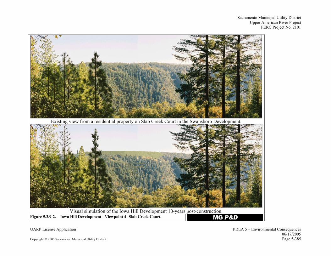
The visual simulations prepared from Viewpoints 4 and 5 depict the most significant visual effects associated with the upper Iowa Hill Development site. See Figure 5.3.9-1 for the locations of Viewpoints 4 and 5.
Viewpoint 4 is located at a private residence off of Slab Creek Court in Swansboro. Views of the Iowa Hill Development from lots on Log Cabin Lane (north of Slab Creek Court, and off of White Oak Drive (south west of Slab Creek Court) could be similar to those experienced from Slab Creek Court. From these lots there could be views of the west slope of Iowa Hill, where several of the Iowa Hill Development features will be seen (DTA and Goodavish 2005b, page 38).
From Viewpoint 4 and similar views, the Iowa Hill Development will alter the existing naturally-appearing character of Iowa Hill by the introduction of engineered features common to hydroelectric development (Figure 5.3.9-2). The upper reservoir berm, switchyard, and transmission line will be visually apparent. The area cleared for the ventilation shaft portal and the access road will also be seen. The introduction of these features will alter the characteristic landscape as seen from this viewpoint (DTA and Goodavish 2005b, page 39).
At ten years post-construction the visual contrasts associated with the Iowa Hill Development will soften. Vegetation will be established on the berm, and the temporary spoil piles and other disturbed areas replanted or hydroseeded. The color of the revegetated berm slopes will be darker than one year post-construction and similar to the surrounding forested landscape. There could be more texture on the berm similar to the surrounding forest; however, this will be dependent on the plant species chosen for revegetation. The lessening of color contrasts through revegetation of the berm will soften the contrast of the berm form with the surrounding landscape; however, the berm will remain visually apparent due to the scale and contrast in form with the surrounding landscape (DTA and Goodavish 2005b, page 39).
Because the transmission towers are proposed to be constructed of COR-TEN® steel, which darkens to a natural dark brown color, the darker color of the berm ten years post construction will also reduce their visibility. While the sky-lined portion of the towers will be noticeable, the rest of the towers will probably blend in with the surrounding landscape. As trees matured around the switchyard, this area will be partially screened from view. Disturbed areas that had been hydroseeded will have established grasses and shrubs, softening the disturbed character and reducing the visual contrasts with the surrounding landscape such that they will not be readily noticeable.
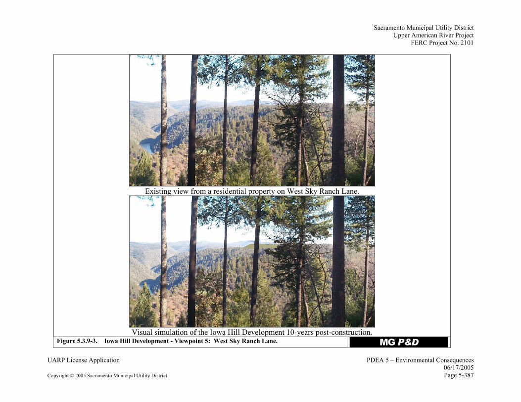
Viewpoint 5 is located on the property of a private residence at the west end of Sky Ranch Lane, off of North Canyon Road on the south side of the SFAR in the Apple Hill area. The views of the Iowa Hill Development from west Sky Ranch Lane could be similar to those from other
Sacramento Municipal Utility District Upper American River Project
properties along the canyon edge in the Apple Hill area including Chute Camp Road and a private drive off of Slab Creek Dam Access Road.
From Viewpoint 5 and similar views, the Iowa Hill Development will change the existing naturally-appearing character of Iowa Hill; however, it will not dominate the view (Figure 5.3.9-3). Other engineered features associated with the Iowa Hill Development, including the transmission line and towers, switchyard, and ventilation shaft portal entrance and road, will not be readily noticeable due to the distance from the site. The angular form, smooth texture and brownish-green color of the berm will be in contrast the surrounding dark-green forested landscape. While the berm is large in scale, from this distance it does not dominate the view (DTA and Goodavish 2005b, page 40).
Similar to the discussion of Viewpoint 4, at ten years post-construction the visual contrasts associated with the Iowa Hill Development will soften. The vegetation on the berm will be darker than one year post-construction and similar to the surrounding forested landscape. The berm will be noticeable to an observer of the landscape, but not readily apparent. Other Iowa Hill Development features will not be noticeable (DTA and Goodavish 2005b, page 40).
The current design the Iowa Hill Development will have short-term visual effects on views from residences to the west and north along the SFAR and Iowa Canyon Creek canyon edges. However, with implementation of the Visual Resources Protection Plan, the visual effects of the Iowa Hill Development will be reduced to a less-than-significant level. The short-term visual effects of the Iowa Hill Development are associated with the visibility of the berm, switchyard, and transmission line at the upper reservoir site. These effects will be reduced by the Visual Resources Protection Plan to a less-than-significant level such that the switchyard, transmission towers, and corridor will not be apparent from residential areas. While the berm may be noticeable, it will be visually subordinate and will not dominate the view of Iowa Hill 10 years post-construction.
The Visual Resources Protection Plan will be developed in consultation with interested parties, then filed with the FERC for approval. In order to reduce the potential effects to a less-than-significant level, SMUD will include the following measures, or comparable measures developed during consultation, in the Visual Resources Protection Plan:
• Relocate the switchyard to the north side of the berm, near the potential equipment staging/laydown area. This will result in the elimination of the first three transmission towers that currently cross in front of the north side of the berm. The relocation of the switchyard and elimination of the first three transmission line towers should eliminate the visibility of the switchyard and transmission line from areas to the west and significantly reduce the visibility from areas to the northwest of the upper reservoir berm.
• Reduce the visual appearance of the powerhouse tunnel portal site by reducing the size of the cut slope at the entrance portal. Construct retaining walls to reduce height of the cut slope at the powerhouse tunnel portal site. Use colored concrete for the exterior framing of the powerhouse tunnel portal and retaining walls. Use dark colored concrete that blends with the surrounding colors in the natural landscape.
Sacramento Municipal Utility District Upper American River Project FERC Project No. 2101
• Consider options to further reduce visual appearance of the upper reservoir berm, consistent with power generation needs.
Slab Creek Reservoir Elevations
The use of the Iowa Hill Development will vary day-to-day depending upon on a variety of factors. There will be times when the development is not in use, times when the pumping/generation cycle is heavily used, and a variety of in-between cases representing moderate levels of daily use. Under the “heavy use” scenario of operation, water elevations in Slab Creek Reservoir will exhibit an average daily increase then decrease of 9-15 feet (maximum of 30 feet) rather than the current weekly fluctuation of approximately 30 feet. The operation of the Iowa Hill Development will not change the maximum fluctuation in Slab Creek Reservoir. Reservoir elevations will generally rise during daylight hours, in response to generation, and fall during nighttime hours, in response to pumping (pg. 41, DTA and Goodavish 2005b). Photographs of various Slab Creek Reservoir elevations representative of the range of elevations that will occur under Iowa Hill Development operation were assessed from the two Slab Creek Reservoir access points, the west end near the dam, and the east end off of Forebay Road. Results of the photographic documentation for both the west end and the east end indicate that operation of the Iowa Hill Development will not alter the visual appearance of the reservoir because the elevations will be within the range of typical existing UARP operation, however the frequency of fluctuation will increase. At the west end, the visual affects of the likely lowest reservoir drawdowns are noticeable and can detract slightly from the reservoir aesthetics; at the east end, there is a slight mark or “bath tub ring” appearance that is not seen at full pool. The mark is softened by the highly textured character of the canyon slopes and is not readily noticeable, and the view is near-natural appearing (pgs. 41-43, DTA and Goodavish 2005b).
Consistency with ENF LRMP and El Dorado County General Plan
The proposed Iowa Hill Development is generally consistent with the visual management direction of the ENF LRMP and the El Dorado County General Plan. The evaluation of consistency with this visual management direction is based on the appearance of the Iowa Hill Development ten years post-construction with both the measures that have been incorporated into the design of the Iowa Hill Development and the additional measures described above. The Iowa Hill Development can be classified as two sites based on visibility of features, the upper site, which includes the upper reservoir, ventilation shaft portal entrance, switchyard, and the transmission line, and the lower site, which includes the portal entrance for the powerhouse tunnel. The upper Iowa Hill Development site is consistent with the LRMP general direction for “moderate visual constraint,” and the standard and guideline of “minimizing impacts on Forest resources…”. With the enhancement measures already incorporated into the Iowa Hill Development, and the implementation of additional measures, the upper reservoir berm will borrow textures and colors from the natural landscape, which will reduce the visual contrasts of the berm with the surrounding landscape. Although the form of the berm will be noticeable, the
Sacramento Municipal Utility District Upper American River Project
other features at the upper site – the switchyard, transmission line, and ventilation shaft portal entrance area and road will remain visually subordinate to the characteristic landscape.
The lower Iowa Hill Development site will be generally consistent with the standard and guideline of “minimizing visual impacts” since several primary features of the Iowa Hill Development were designed to not be visible in this area: the powerhouse and water conveyance system (e.g., penstock and intake/discharge structure) will be underground or underwater and the switchyard and transmission line towers were relocated to the upper site to reduce the area of disturbance in the SFAR canyon.
Thus, the only above-ground features at the lower site are the powerhouse tunnel entrance portal and the minor widening of the existing 0.8-mile-long access road to it. The road widening will consist of a three-foot expansion with minor cut slopes that will be consistent with the “foreground retention” direction of the LRMP. Construction of the powerhouse tunnel entrance portal will likely require cutting back the canyon slope to create a level area for the entrance portal, which will result in a cut slope of up to approximately 60 feet. A retaining wall below the portal entrance area and the exposed framing of the entrance portal itself will be concrete and colored a dark brown to blend with the surrounding landscape. This feature of the development will only be visually evident from a narrow area of the reservoir. It will not be visible over most of the reservoir area due to steep topography and the reservoir’s narrow and serpentine shape. Nevertheless, this one feature of the lower site may be in conflict with the foreground retention direction, and SMUD is committed to working with the ENF to ensure that final site design for the powerhouse tunnel entrance renders it consistent with this foreground retention direction. The El Dorado County General Plan most directly addresses the County’s visual and scenic quality objectives and policies within the Land Use Element. (The Conservation and Open Space Element also contains general references to protection of aesthetic and scenic quality of the County.) The Land Use Element includes policies that specifically require the creation of greenbelts and incorporating open space into new development, the creation of community design guidelines for “Rural Centers,” as well as the creation of a scenic corridor ordinance for several potentially visually important areas identified in the General Plan. The Iowa Hill Development does not conflict with these policies as the project includes ample open space around the reservoir, will not preclude the development of community design guidelines in nearby communities, and the project site was not identified in the General Plan as a potentially visually sensitive area that should be included in the development of the Scenic Corridor Ordinance.
Design of the Iowa Hill Development has incorporated several measures to minimize visual effects of the project. The Iowa Hill Development with implementation of the Visual Resource Mitigation Plan is consistent with the objectives of the El Dorado County General Plan as it minimizes the visual effect of the development.
Sacramento Municipal Utility District Upper American River Project FERC Project No. 2101
The proposed Iowa Hill Development is located in a remote and forested area near the communities of Mosquito/Swansboro and Camino, placing it in a rural area where a small number of privately-owned residential properties may be affected by a change in noise levels (pg. 13, DTA and CH2M HILL 2005a). Most of the nearby residences with potential to be affected by construction noise are located in Swansboro, approximately one mile northwest of the proposed upper reservoir, along the north canyon rim of the South Fork American River. There are also a few homes south of the upper reservoir site (along or near Copperton Road) within one mile of the upper reservoir, and several more homes are located approximately one mile southwest of the upper reservoir site (Figure 5.3.9-1). Residences closest to the upper reservoir site lie within a group of 28 privately-owned parcels (all but four without residences) along Iowa Hill Road. Some of these parcels abut the proposed FERC Project Boundary for the Iowa Hill Development. There are no utility services (e.g., electricity, water) in the vicinity of Iowa Hill, therefore current and future development is limited.
The construction of the Iowa Hill Development has the potential to generate noise levels that could be disturbing to residents living in the surrounding area and to recreational visitors at the informal boat launch site at Slab Creek Reservoir. While a large portion of the construction activities will take place underground, construction of the upper reservoir atop Iowa Hill will generate noise as earth-moving equipment clear the site and build the reservoir berm. Operational noise associated with the Iowa Hill Development is unlikely to be an issue as noise-generating facilities (the powerhouse and intake structure) will be located underground (pgs. 25-27, DTA and CH2M HILL 2005a).
Under the Proposed Action, SMUD will prepare a Noise Attenuation Plan. This plan will identify measures necessary to reduce construction noise at sensitive receptors to acceptable levels as identified in the Public Health, Safety and Noise Element of the El Dorado County General Plan (EDC General Plan) (El Dorado County 2004) to the maximum extent possible. Measures will likely include limiting the hours and days of noise-generating, aboveground construction activities, monitoring of blasting activities, and establishing monitoring protocols to record noise levels at the sensitive receptors during all phases of construction. The sensitive receptors will include those used for the Auditory Assessment of Iowa Hill Construction and Operations Technical Report (DTA and CH2M HILL 2005a) and any new receptors identified during the development of the Noise Attenuation Plan. The plan will also include community response methods to allow the public to inform SMUD of any unusually annoying noise events and establish protocols for responding to such events. The final plan will be developed in consultation with interested parties and approved by the FERC.
The noise analysis provides an overview of local and federal noise standards and estimates noise levels for aboveground construction activities. Current noise sources in the Iowa Hill Development area include logging activities, aircraft, and light vehicle traffic (pg. 13, DTA and CH2M HILL 2005a). There are several different ways to measure noise, depending on the source of the noise, the receiver, and the reason for the noise measurement. To evaluate noise at the Iowa Hill Development, noise was defined in terms of decibels on the A-weighted scale (dBA). Noise levels stated in terms of dBA reflect the response of the human ear by filtering out
Sacramento Municipal Utility District Upper American River Project
some of the noise in the low and high frequency ranges that the ear does not detect well. The A-weighted scale is used in most ordinances and standards (pg. 4, DTA and CH2M HILL 2005a).
Laws, ordinances, regulations, and standards applicable to noise generation at the Iowa Hill Development include the 2004 EDC General Plan and FERC guidelines. Construction noise standards for rural regions in the EDC General Plan vary between 40 and 65 dBA depending on the time of day (daytime, evening, and night) and between hourly-average and maximum levels (Table 5.3.9-1). As most construction activities will occur between 7 a.m. and 7 p.m., EDC General Plan requires an hourly average of 50 dB and a maximum of 60 dB. The most restrictive hourly-average guideline for operational noise is the nighttime (10 p.m. to 7 a.m.) standard for rural residential areas of 40 dBA (pg. 265, EDC GP 2004). By comparison, the FERC guideline for maximum operational noise is 49 dBA (pg. 21, DTA and CH2M HILL 2005a).
Table 5.3.9-1. 2004 El Dorado County General Plan construction noise limits for rural regions. (Pg. 266, EDC GP 2004)
Noise Level (dB) Land Use Designation
Time Period Leq
1 Lmax 7 a.m.–7 p.m. 50 60
7 p.m.–10 p.m. 45 55 All Residential
10 p.m.–7 a.m. 40 50 7 a.m.–7 p.m. 65 75 Commercial, Recreation, and Public Facilities
7 p.m.–7 a.m. 60 70 7 a.m.–7 p.m. 65 75 Rural Land, Natural Resources, Open Space, and
Agricultural Lands 7 p.m.–7 a.m. 60 70 1The equivalent sound pressure level (Leq) is the average noise level, on an energy basis, over one hour. The EDC General Plan standards shown in Table 5.3.9-1 are generally applicable when construction activities occur between 7:00 a.m. and 7:00 p.m., Monday through Friday, and 8:00 a.m. and 5:00 p.m. on weekends and holidays. Exceptions to these times are allowed in situations where construction beyond these hours is necessary to alleviate traffic congestion and safety hazards (pg. 265, EDC GP 2004). Most construction work at the Iowa Hill Development will begin at 6:30 a.m. As described in Section 5.3.10.3 (subsection Local Roads and Traffic Congestion), starting construction work at 6:30 a.m. will reduce local construction-related traffic congestion and safety hazards.
Construction Noise at Nearby Residences
A “worse case” construction noise model and noise contours were developed for the Iowa Hill Development. This analysis assumed 70 pieces of heavy equipment operating at the upper reservoir site simultaneously and did not take into account shielding provided by the excavation or reservoir berm (when the line of sight between the construction equipment and receptor is obstructed). Additionally, foliage effects (reductions related to the forested nature of the area) were not taken into consideration (pg. 21, DTA and CH2M HILL 2005a).
Sacramento Municipal Utility District Upper American River Project FERC Project No. 2101
The noise model predicted average levels ranging from 40 to 50 dBA at the residential area northwest of the project (north canyon rim of the South Fork American River) and south of the project (near Copperton Road), and from 40 to 60 dBA at the residential properties located to the east of the upper reservoir (pg. 21-23, DTA and CH2M HILL 2005a). Construction noise may result in increases of daytime noise levels of approximately 10 dBA at residential areas along the north canyon rim of the South Fork American River in Swansboro and along Copperton Road in Camino (pg. 1, DTA and CH2M HILL 2005a).
Blasting Noise at Nearby Residences
There are no federal requirements, reports, or guidelines for blasting that specifically apply to the Iowa Hill Development. However, in 1983 the U.S. Bureau of Mines (now the Department of Interior’s Office of Surface Mining) released Report of Investigations 8507: Structure Response and Damage Produced by Ground Vibrations from Surface Mine Blasting (RI8507). This report contains guidelines for blasting for surface mining operations; additionally, there are federal requirements regulating surface mining blasting (30 CFR Part 816‚ Section 67 §816.67 and §817.67). While these requirements do not directly apply to the Iowa Hill Development as the Proposed Action does not include surface mining, they serve as a guide or industry “best practice” and all blasting will be conducted by a qualified firm in accordance with the federal criteria in RI8507 to minimize disruption. Blasting for the construction of the Iowa Hill Development is anticipated to occur twice per work day, over a period of 24 months, and is anticipated to be less than 85 dBA (based on the 133 dB peak level) at all residences (pgs. 22-25, DTA and CH2M HILL 2005a). The blasting will be less disruptive (lower noise levels will be achieved) over time as activities progress underground. Industry standards usually do not regulate blasting in terms of dBA, but have identified a limit of 133 dB (unweighted) that is measured with a blasting monitor that has a sensitivity of 2 Hz or less. The Iowa Hill Development will exceed the maximum noise threshold set by EDC General Plan (60 dB), however, the blasting will meet federal and industry standards and any disruption will be temporary in nature.
Traffic Noise at Nearby Residences
It is unlikely that construction traffic will affect noise levels along U.S. Highway 50 (pg. 22, DTA and CH2M HILL 2005a). Transportation corridor traffic noise levels on local roads is anticipated to be between 55 and 70 dBA at 30 feet from the roadway and to decrease by at least 3 dBA for each doubling of distance (for example, 52 to 67 dBA at 60 feet). The range in noise stems from the assumption of the type of vehicles: if 100 percent of the traffic consists of cars/pickup trucks, the modeled result at 30 feet is approximately 55 dBA and if 100 percent of the traffic consists of heavy trucks (semis) the modeled result at 30 ft is approximately 70 dBA. The Iowa Hill Development construction traffic will be approximately 80 percent cars/pickup trucks, 10 percent medium trucks (6 tires), and 10 percent heavy trucks, resulting in traffic noise levels of approximately 61 dBA at 30 feet.
Most homes located adjacent to the roads to be used to access the Iowa Hill Development, (e.g., Carson, Cable, Larsen Drive, North Canyon), are located approximately 100 feet or more from
Sacramento Municipal Utility District Upper American River Project
the road. Based on site visits and county assessor maps (see Figure 5.3.9-1 which shows property parcel lines and roads), there are about 30 homes located approximately 30 to 50 feet from a road to be used to access the Iowa Hill Development: about 12 homes along Cable Road (primarily from Mace Road to Sierra Express Drive); about six homes along North Canyon Road; and about 12 homes in the Camino town center area. These residents may experience short-term daytime construction traffic noise levels near the maximum noise threshold of the EDC General Plan (60 dB).
Iowa Hill Development Noise Summary
The construction of the Iowa Hill Development with implementation of a Noise Attenuation Plan will ensure construction noise levels are within the noise standards established by El Dorado County and federal regulations to the maximum extent possible. Noise from construction activities will only exceed the EDC requirements at one residence. Blasting activities will exceed the El Dorado County maximum noise threshold, but will meet federal guidelines. Noise from construction traffic will meet the requirements of the El Dorado General Plan at all but about three-dozen residences that may occasionally experience noise levels near the maximum noise threshold. Although the construction and blasting noise impacts are temporary, these are considered significant effects as the noise levels exceed the thresholds in the EDC General Plan.
5.3.9.4 Environmental Effects of the UARP-Only Alternative
Under the UARP-only Alternative, all components of the Proposed Action will be in place except those dealing with the addition of the 400 MW Iowa Hill Development. SMUD will operate the existing UARP facilities in a manner identical to the Proposed Action, with few exceptions. All project reservoirs, except Slab Creek Reservoir, will be operated in the same manner described in Exhibit B of the License Application; the seasonal changes in water levels of the three project storage reservoirs (e.g., Figures 5.3.1-11 through 5.3.1-25 of Section 5.3.1.3), will occur under the alternative. However, the increased frequency of water level fluctuation at Slab Creek Reservoir described under the Proposed Action will not occur under the UARP-only Alternative. Slab Creek Reservoir water level fluctuations, under this alternative, will be the same as baseline. The release schedule for the ten project dams will be the same as the Proposed Action. Thus, the quantity of water stored in project reservoirs (with seasonal and daily changes) and the volume of water passing through project reaches will be largely the same as the Proposed Action. The effects of the UARP-only Alternative on aesthetic and noise resources will be, in large measure, identical to those described for the Proposed Action in Section 5.3.9.3. In general, operation of the UARP under this alternative will have the same reservoir release schedule as the Proposed Action. This alternative, like the Proposed Action, will not significantly affect noise levels, aesthetics of the reservoir levels, or project features. Because this alternative does not include the construction or operation of the Iowa Hill Development, potential effects of the development on visual resources and noise levels will not exist. Without the 400 MW of capacity from the Iowa Hill Development, SMUD will have to meet future peak generation needs with less efficient simple-cycle peaking plants rather than power purchased from the
Sacramento Municipal Utility District Upper American River Project FERC Project No. 2101
energy market, which would likely be produced by a more efficient mix of fossil fuel generation sources.
5.3.9.5 Unavoidable Adverse Impacts
Construction-related noise of the Iowa Hill Development will affect the residents of a 10-acre, developed parcel (APN 100-030-50), located 500 feet to the east of the upper reservoir. Additionally blasting impacts will affect nearby residences and construction traffic noise may occasionally affect residents of about three dozen homes. While these are short-term effects, they are deemed significant, as the noise will exceed the thresholds in the EDC General Plan.
")
")
")")
")
# # # ##
# ##
# # #
Canyon
Long
Brus
h
Cree k
CanyonIowa
One E
ye Creek
Creek
Slab
Creek
John
Slab
Redbird
Creek
ReservoirCreek
South Fork American River
South Fork One Eye Creek
South
Fork American Riv e r
Nelson RdMu
ir Dr
Ghost Ln
Copperton RdMace RdLarsen Dr
Audubon Dr
Chute
Camp Road
Roadrunner Ln
Hidden Valley Ln
Hassler Road
Harness Tr act
Gilmore RdCrocker Ranch Rd
Stope Dr
Pinene
edle Ln
Lupine L n
Deer Canyon Ct
Buckeye Ct
Pawdick Ct
Maid u
Dr
Slab Creek Ct
White O ak Dr
LogCabin Ct
Skyview Dr
Copperton Rd
Hanks Rd
Blubell Dr
Adney Wy
Windin g
Ln
Ponde rosa Grove Dr
Stope
Dr
Edi s on Trail
Log Cabin Ln
Log Cabin Ln
North Canyon Rd Apple Tree Ln
S tope
Dr
Dogwood Ln
W
ildflower Ct
Apple Vista Ln
Rio Vista W ay
Dickinson Rd
Stope Dr
E xpress DrSierra
Cableview Ct
Halls
Farm
Rd
Sky R
anch
Ln
Forebay Road
Iowa Hill Road
Iowa H il l Ro
ad
Cable Road
Sla b Cree
k Dam
Acces
s Road
Slab Creek Reservoir Access Roa
dC a b le Road
Cable Road
SWANSBORODEVELOPMENT
APPLE HILL
CAMINO
ELDORADO
NATIONAL
FOREST
Figure 5.3.9-1. Iowa Hill Development Plan View and Location of Visual Simulation Viewpoints.
Eldorado County Parcel BoundariesEldorado National Forest BoundarySwitchyardOrganic Soil Storage AreaVentilation Shaft Portal
Field Office SiteReservoir BermProject BoundaryEquipment Laydown AreaProposed Transmission Line
Facility RoadsUARP Transmission Line
0 925 1,850 2,775 3,700462.5 Feet
1 - Cableview Court Viewpoint
2 - Log Cabin Lane Viewpoint
4 - Slab Creek Court Viewpoint
5 - West Sky Ranch Lane Viewpoint
3 - East Sky Ranch Viewpoint
VESTRA Resources, Inc. 07 April 2005
42
1
5
3
Sacramento Municipal Utility District Upper American River Project
Existing view from a residential property on Slab Creek Court in the Swansboro Development.
Visual simulation of the Iowa Hill Development 10-years post-construction. Figure 5.3.9-2. Iowa Hill Development - Viewpoint 4: Slab Creek Court. MG P&D
Sacramento Municipal Utility District Upper American River Project