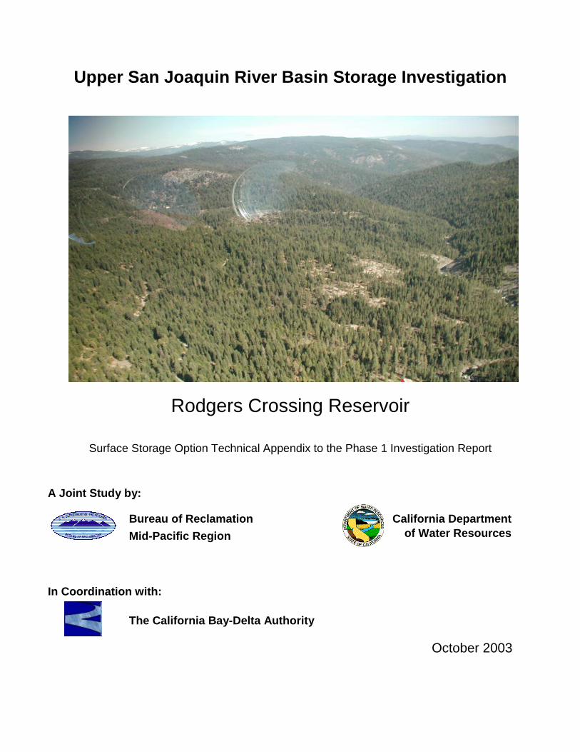
Upper San Joaquin River Basin Storage Investigation Rodgers Crossing Reservoir Surface Storage Option Technical Appendix to the Phase 1 Investigation Report A Joint Study by: Bureau of Reclamation Mid-Pacific Region California Department of Water Resources In Coordination with: The California Bay-Delta Authority October 2003
Transcript
Upper San Joaquin River Basin Storage Investigation
Rodgers Crossing Reservoir
Surface Storage Option Technical Appendix to the Phase 1 Investigation Report
A Joint Study by:
Bureau of Reclamation
Mid-Pacific Region
California Departmentof Water Resources
In Coordination with:
The California Bay-Delta Authority
October 2003
Upper San Joaquin River Basin Storage Investigation
Rodgers Crossing in the Vicinity of the Potential Dam Site
Rodgers Crossing Reservoir
Surface Storage Option Technical Appendix to the Phase 1 Investigation Report
A Joint Study by:
Bureau of Reclamation
Mid-Pacific Region
California Departmentof Water Resources
In Coordination with: Prepared by:
The California Bay-Delta Authority
October 2003
Upper San Joaquin River Basin i October 2003Storage Investigation
SURFACE WATER STORAGE OPTION
TECHNICAL MEMORANDUM
RODGERS CROSSING RESERVOIR
UPPER SAN JOAQUIN RIVER BASIN STORAGE INVESTIGATION
TABLE OF CONTENTS
Chapter Page
ACRONYMS AND ABBREVIATIONS LIST...............................................................iv
AVAILABLE TOPOGRAPHIC MAPPING .........................................................................2-1
AVAILABLE AERIAL PHOTOGRAPHY ...........................................................................2-1
CHAPTER 3. GEOLOGIC AND SEISMIC SETTING ............................................ 3-1
SITE GEOLOGY..............................................................................................................3-1SITE GEOTECHNICAL CONDITIONS.............................................................................3-2
RESERVOIR ELEVATION/CAPACITY CURVE...............................................................5-2APPURTENANT FEATURES ..........................................................................................5-2
Initial Construction Costs................................................................................... 5-6Operations and Maintenance Costs .................................................................. 5-6
SYSTEMS OPERATIONS ...............................................................................................5-6
CHAPTER 6. HYDROELECTRIC POWER OPTIONS .......................................... 6-1
ADDED HYDROELECTRIC POWER TO EXISTING STRUCTURES ..............................6-1
NEW HYDROELECTRIC POWER...................................................................................6-1TRANSMISSION AND DISTRIBUTION ...........................................................................6-1
LAND USE.......................................................................................................................7-6
Constraints ........................................................................................................ 7-6MINING AND OTHER PAST ACTIVITIES .......................................................................7-6
Rodgers Crossing ReservoirSurface Storage Option Technical Appendix Table of Contents
Upper San Joaquin River Basin iii October 2003Storage Investigation
Constraints ........................................................................................................ 7-6HAZARDOUS AND TOXIC MATERIALS .........................................................................7-6
TABLE 5-1. POSSIBLE PERMITS REQUIRED...........................................................5-4TABLE 5-2. SUMMARY OF FIRST COSTS ................................................................5-6
LIST OF FIGURES
FIGURE 1-1. RODGERS CROSSING SITE LOCATION MAP....................................1-2FIGURE 1-2. RODGERS CROSSING VICINITY.........................................................1-3FIGURE 1-3. POTENTIAL FEATURES AND INUNDATED FACILITIES ....................1-6FIGURE 5-1. CROSS SECTION OF POTENTIAL CONCRETE ARCH DAM .............5-1FIGURE 5-2. RESERVOIR ELEVATION VS. CAPACITY CURVE..............................5-2
LIST OF APPENDICES
APPENDIX A ENGINEERING FIELD TRIP REPORT
APPENDIX B ENVIRONMENTAL FIELD TRIP REPORT
APPENDIX C COST ESTIMATE SUMMARY
Rodgers Crossing ReservoirTable of Contents Surface Storage Option Technical Appendix
October 2003 iv Upper San Joaquin River BasinStorage Investigation
Acronyms and Abbreviations List
CDFG California Department of Fish and Game
CEQA California Environmental Quality Act
CFRF concrete-faced rockfill
cfs cubic feet per second
Corps United States Army Corps of Engineers
elevation number of feet above mean sea level
HEP Habitat Evaluation Procedure
IECO International Engineering Company, Inc.
Investigation Upper San Joaquin River Basin Storage Investigation
KRCD Kings River Conservation District
MW megawatt
NEPA National Environmental Policy Act
PG&E Pacific Gas and Electric
RCC roller-compacted concrete
Reclamation Bureau of Reclamation
ROD Record of Decision
TAF thousand acre-feet
TM Technical Memorandum
USFS United States Forest Service
USFWS United States Fish and Wildlife Service
USGS United States Geological Survey
Upper San Joaquin River Basin ES-1 October 2003Storage Investigation
EXECUTIVE SUMMARY
The Upper San Joaquin River Basin Storage Investigation (Investigation) considered severalpotential storage options in the eastern San Joaquin Valley. This document describes apotential dam at Rodgers Crossing on the main stem of the Kings River at river mile 116,approximately one-half mile upstream of its confluence with the North Fork. Two damoptions had been studied previously by others: a roller-compacted concrete embankment damup to 660 feet above streambed level that would create a reservoir of up to 950 thousandacre-feet (TAF), and a 400-foot-high concrete arch dam that would create a reservoir of up to295 TAF. The larger dam would inundate about 12 miles of upstream river, and the smalleroption would inundate about 8 miles of river. Stored water would be released to the KingsRiver to offset releases from Millerton Lake.
Foundation conditions at the potential dam site appear suitable, and raw material for aconcrete dam is available. Several potential quarry sites were identified from which concreteaggregate could be obtained. Electric power distribution facilities are present in the area, andconstruction staging would be possible at upstream and downstream locations.
Environmental impacts associated with this storage option would be significant. The KingsRiver is one of the least disturbed large rivers in California and its wild trout population isconsidered one of the finest in the State. The California Department of Fish and Game(CDFG) designated the stretch upstream of Pine Flat Lake to the confluence of the Middleand South Forks as a Wild Trout Fishery. The river is also a Federally designated Wild andScenic River starting about 9.2 miles above the potential dam site. The inundation area of thelarger reservoir option considered would extend into the Wild and Scenic portion of the river.Both reservoir options would inundate portions of the Kings River Special ManagementArea. Inundation of either the Wild and Scenic reach or the Special Management Areawould require Congressional approval.
Construction of a reservoir at Rodgers Crossing would be expected to cause unmitigableimpacts to recreational resources in the area. Four United States Forest Service campgroundsare located along the river and commercial and private whitewater rafting is conducted on themain stem of the Kings River above Pine Flat Reservoir. Extensive riparian habitat wouldalso be lost by creation of a Rodgers Crossing reservoir, which would pose a mitigationchallenge because of the amount of habitat that would need to be restored or enhanced tocompensate for the loss. An important spawning area for several native fish speciesdesignated as State Species of Special Concern by CDFG in Mill Flat Creek, about 2 milesupstream of the potential dam site, would be adversely affected.
This option was dropped from further consideration in the Investigation for several reasons.The extent of recreational impacts that would result from constructing Rodgers CrossingReservoir may be unmitigable and the ability to mitigate fishery impacts appears low. Also,an act of Congress would be required to permit inundation of the Kings River SpecialManagement Area.
October 2003 ES-2 Upper San Joaquin River BasinStorage Investigation
THIS PAGE LEFT BLANK INTENTIONALLY
Upper San Joaquin River Basin 1-1 October 2003Storage Investigation
CHAPTER 1. INTRODUCTION
The Bureau of Reclamation, in cooperation with the California Department of WaterResources, is completing the Upper San Joaquin River Basin Storage Investigation(Investigation) consistent with the CALFED Bay-Delta Program Record of Decision (ROD),August 2000. The Investigation will consider opportunities to develop water supplies tocontribute to water quality improvements in and restoration of the San Joaquin River, and toenhance conjunctive management and exchanges to provide high-quality water to urbanareas. The ROD indicated that the Investigation should consider enlarging Friant Dam ordeveloping an equivalent storage program to meet Investigation objectives.
The Investigation identified several potential surface storage sites to be initially consideredthrough prefeasibility-level studies of engineering and environmental issues. This TechnicalMemorandum (TM), which was prepared as a technical appendix to The Phase IInvestigation Report, presents findings from a prefeasibility-level review of the potentialRodgers Crossing Dam and Reservoir.
OPTION SUMMARY
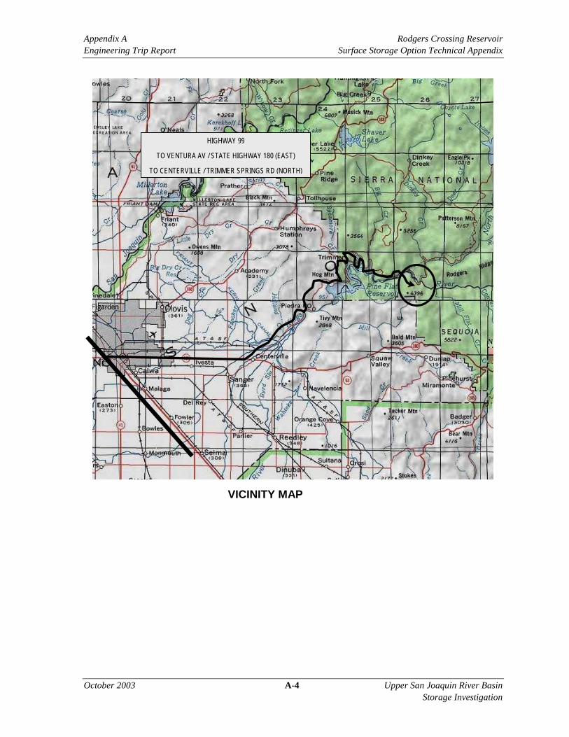
The potential Rodgers Crossing Dam site is located in Fresno County, near Balch Camp,about 40 miles east-northeast of Fresno (Figure 1-1). The dam site is located upstream ofPine Flat Reservoir on the main stem of the Kings River, approximately 1 mile upstream ofits confluence with the North Fork of the Kings River (Figure 1-2).
As proposed in 1974, constructing a 400-foot-high dam at Rodgers Crossing would create upto 295 thousand acre-feet (TAF) of storage capacity. This option would be able to producenew hydroelectric energy from two 105 megawatt (MW) generating units.
Water stored in Rodgers Crossing Reservoir would be released to the Kings River. Releaseswould be exchanged for water diverted from Millerton Lake or would offset Millertonreleases to the San Joaquin River.
EXISTING FACILITIES
No water storage facility presently exists at the site. Pacific Gas and Electric (PG&E)operates three hydroelectric power projects in the Kings River basin: the Kings River Project,the Balch Project, and the Helms Pumped Storage Project, which uses Wishon Reservoir asthe afterbay and Courtwright Reservoir as the forebay.
October 2003 1-4 Upper San Joaquin River BasinStorage Investigation
SUMMARY OF PREVIOUS INVESTIGATIONS
In 1965, a Committee of Engineers issued a Progress Report on the Kings River WaterUtilization Projects upstream from Pine Flat Reservoir for the Kings River WaterAssociation. This report evaluated three alternative storage sites, including Junction Dam onthe main stem of the Kings River just downstream of its confluence with the North Fork,Rodgers Crossing Dam on the main stem just upstream of the North Fork confluence, andMill Creek Dam on Mill Creek, which joins the Kings River from the south just downstreamof Pine Flat Dam.
Of the three sites evaluated, only the 295 TAF Rodgers Crossing site was consideredeconomically feasible. However, based on power sales alone, this option was not consideredeconomically feasible; it was concluded that this option would have to be supported byirrigation interests and/or be constructed in conjunction with other power projects.
In 1974, a Master Plan of the Kings River Service Area was prepared for the Kings RiverConservation District (KRCD) by International Engineering Company, Inc. (IECO). TheMaster Plan recommended a course of action that would 1) provide a balanced water supply;2) minimize flood damage; and 3) conserve and develop water and power resources. Onealternative evaluated was a 400-foot-high thick concrete arch dam at Rodgers Crossing. Thereport concluded that the KRCD service area was deficient in water, and that unlessadditional water supplies were obtained, groundwater would be overdrafted such that a largesegment of the agricultural service area would ultimately have to revert to dry farming.
To address the issue, IECO concluded that a staged development of the recommendedalternatives be pursued. The Rodgers Crossing Dam alternative was not consideredeconomically feasible at the time of the investigation, but was retained as an alternativebecause future economic conditions might render it feasible.
A study conducted for the Friant Water Users Authority and Natural Resources DefenseCouncil Coalition considered a roller-compacted concrete (RCC) embankment dam up to 660feet high at Rodgers Crossing. A structure of this size would create a reservoir with a storagecapacity of over 950 TAF (URS, 2000). The maximum gross pool water surface elevationfor such a reservoir would be approximately 1,650 feet above mean sea level (elevation1,650). The study contained no designs for this larger dam option, and limited technicalinformation.
POTENTIAL IMPROVEMENTS CONSIDERED
Due to the limitations of the available information regarding the larger 660-foot embankmentdam concept and the more severe environmental impacts such an option would create, thisTM focuses on the 400-foot concrete arch dam proposed in the 1974 KRCD Master Plan.The engineering analysis in Chapter 5 pertains only to the 400-foot-high arch dam proposal.However, some discussion of the environmental aspects of the larger dam concept is includedin Chapter 7.
Upper San Joaquin River Basin 1-5 October 2003Storage Investigation
As proposed in the 1974 KRCD Master Plan, the Rodgers Crossing Dam would be a 400-foot-high, thick concrete arch dam. The dam crest would be at elevation 1,400, resulting in adam height of approximately 400 feet above the riverbed. At this elevation, the crest lengthwould be about 1,660 feet and the maximum reservoir level would be at about elevation1,390 (Figure 1-3). The reservoir would be able to store up to 295 TAF of water.
A power plant was planned for beneath the flip bucket spillway. The powerhouse wouldcontain two 105 MW generating units. A 4-mile steel tower transmission line would connectwith a switchyard at the existing PG&E line at Balch Camp. Switching facilities would beprovided at both ends.
APPROACH AND METHODOLOGY
This TM was prepared from a brief review of the prior studies listed above, an engineeringfield reconnaissance on 13 June 2002 (Appendix A), and an environmental fieldreconnaissance of the dam and reservoir on 29 May 2002 (Appendix B).
During the June 2002 field trip, engineers and geologists examined the site underconsideration. Locations of existing and potential structures were visually assessed.Topography, geology, geotechnical conditions, and utilities were noted. Access routes andpossible borrow, staging, and lay-down areas were considered.
During the May 2002 environmental field visit, specialists in botany, wildlife, aquaticbiology, recreational resources, and cultural resources visually assessed existingenvironmental resources. Additional research was conducted, making use of prior studiesand available literature, the California Natural Diversity Database, topographic maps, andaerial photographs. This information was used to preliminarily identify the extent to whichpotential environmental impacts might constrain storage options under consideration. Whereevident, opportunities for improving environmental resources or mitigating adverse effectswere also noted. Surveys were not conducted and consultations with external resourcemanagement or environmental agencies were not held.
The seismotectonic evaluation conducted by Reclamation (2002) for this study was based onreadily available information and is considered appropriate for prefeasibility-level designsonly. Detailed, site-specific seismotectonic investigations have not been conducted andaerial/remotely sensed imagery was not evaluated.
For prefeasibility-level planning studies, designs and analyses are typically quite general.Extensive efforts to optimize the design have not been done, and only limited valueengineering techniques have been used at this level of study.
October 2003 1-6 Upper San Joaquin River BasinStorage Investigation
FIGURE 1-3. POTENTIAL FEATURES AND INUNDATED FACILITIES
Upper San Joaquin River Basin 2-1 October 2003Storage Investigation
CHAPTER 2. TOPOGRAPHIC SETTING
In the area of the potential dam, the terrain consists of a steep canyon incised into ruggedmountains. The canyons of the watershed have been cut by southwest- to west-flowingrivers and associated large tributaries. The Kings River is the main river in the area. Thetopography of the Kings River basin is the most rugged in the entire Sierra Nevada, rising toover elevation 14,000 in the upper watershed.
Elevations in the immediate area range from about elevation 1,000 to nearly elevation 4,000.The dam site is located in a section of river that passes through a narrow, northwest-trendingV-shaped bedrock canyon. The right abutment slope rises steeply (2:1 horizontal to vertical)to a ridge of nearly elevation 2,700. The left abutment slope rises at a steeper 1.5:1inclination to a ridge of elevation 2,480.
AVAILABLE TOPOGRAPHIC MAPPING
Topographic maps of the study area are publicly available from the United States GeologicalSurvey (USGS). It is presumed that topographic maps of the reservoir and dam site areavailable from the United States Army Corps of Engineers (Corps) at an unknown scale andcontour interval.
AVAILABLE AERIAL PHOTOGRAPHY
Aerial photography of various scales and imagery is available from the archive files of theUSGS. Additional aerial imagery may also be available from the United States Departmentof Agriculture, Reclamation, and the Corps. A specific search of the available photographywas not conducted for this TM nor was any existing aerial photography reviewed.
October 2003 2-2 Upper San Joaquin River BasinStorage Investigation
THIS PAGE LEFT BLANK INTENTIONALLY
Upper San Joaquin River Basin 3-1 October 2003Storage Investigation
CHAPTER 3. GEOLOGIC AND SEISMIC SETTING
The Kings River basin is located within a complex geologic area containing metamorphosedsedimentary and volcanic rocks that have been folded, faulted, and intruded by granitic rocksof three different ages. Volcanism, followed by glaciation and recent stream down-cutting,have modified the topography to essentially the present day landscape. Major geologicstructures trend to the northwest. Bedding and foliation of the rock units typically strikenortherly and dip steeply west. Degree of weathering and jointing is variable, depending onrock type.
Overall, seismic hazard potential at the site is low. Preliminary earthquake loading analysis,for this prefeasibility-level study considered two types of potential earthquake sources: faultsources and areal/background sources (Reclamation, 2002).
Twenty-two potential fault sources for the site were identified. They include those associatedwith the San Andreas fault, seven western Great Valley faults, seven eastern Sierra Nevadafaults, the White Wolf fault of the southern San Joaquin Valley, and six faults of the SierraNevada Foothills system. No major through-going or shear zones have been identified in thisarea of the Sierra Nevada and historic seismicity rates are low.
The areal/background seismic source considered was the South Sierran Source Block, theregion surrounding the site. This region possesses relatively uniform seismotectoniccharacteristics.
Probabilistic seismic hazard analysis performed indicates that peak horizontal accelerationsto be expected at the site are 0.13g with a 2,500-year return period, 0.17g with a 5,000-yearreturn period, and 0.23g with a 10,000-year return period.
SITE GEOLOGY
The potential dam site is located in a relatively steep, narrow, V-shaped canyon of the KingsRiver (Figures 1-2 and 1-3). The general area is characterized by Mesozoic granitics andpre-Cretaceous meta-sedimentary rocks.
In the area of the right abutment, meta-sedimentary rocks outcrop in several places and areexposed in the road cut and in small rills and rivulets trending downslope. The narrow riverchannel contains alluvial sand, gravel, cobbles, and boulders overlying meta-sedimentarybedrock. This bedrock is exposed near the edge of the water on both sides of the river.Therefore, the alluvium is not believed to be deep. The left abutment is also underlain bymeta-sedimentary rocks, consisting mainly of interbedded quartzite and quartz mica schistwith scattered quartz seams, aplite dikes, and locally altered intrusive quartz dikes. As withthe right abutment, these rocks outcrop and are exposed in rivulets and at the road cut (IECO,1974).
October 2003 3-2 Upper San Joaquin River BasinStorage Investigation
The area of the potential reservoir is characterized by pre-Cretaceous meta-sedimentary andsome meta-volcanic rocks intruded by Mesozoic granitic rocks, as shown on the Fresno Sheetof the Geologic Map of California (CDMG, 1966). Some limestone beds trending slightlywest of north have also been mapped within the reservoir area a few miles upstream of thepotential dam site. Bedrock is exposed over much of the area; however, deposits of slopewash, talus, alluvial fan, and alluvium to various depths occur locally. Seepage throughzones of fractured bedrock or limestone should present no major problem, nor wouldproblems be anticipated from landslides or rockfalls after the reservoir is filled.
No significant faults or fault zones are known to exist within the reservoir basin or dam site.
SITE GEOTECHNICAL CONDITIONS
In the proposed right abutment, the foliation/bedding strikes northerly, nearly parallel to theriver, and dips into the abutment at a 50 to 65 degree angle to horizontal. Where exposed inrivulets, the rock is typically unweathered, very hard, and either massive or slightly fractured.In the road cut, the rock ranges from unweathered to moderately weathered and is fracturedand moderately hard. The bedrock is overlain by a thin mantle of slope wash and talus,which may be much deeper in local areas where slumping has occurred (IECO, 1974).
In the proposed left abutment, light gray quartzite beds are typically very hard, brittle,slightly fractured, and slightly weathered at the surface. While the quartz mica schist bedshave a wide range of physical properties, the quartzite is generally weathered brown,moderately hard to locally friable and closely fractured. Foliation/bedding dips out of the leftabutment toward the river at a 50 to 65 degree angle from horizontal. This orientation,combined with the major joint pattern occurring at nearly right angles, creates a blocky tocubic breaking pattern for most of the rock. Other fractures occur at various orientations.Overlying the bedrock are scattered, shallow deposits of slope wash and talus. Locally, thesedeposits are deeper, particularly in areas of highly weathered schist. Fill material from roadconstruction generally masks the bedrock to river level (IECO, 1974).
There is no apparent change in the attitude of foliation/schistocity across the river to indicatefaulting in the channel (IECO, 1974).
Upper San Joaquin River Basin 4-1 October 2003Storage Investigation
CHAPTER 4. HYDROLOGIC SETTING
The Kings River watershed upstream of the potential Rodgers Crossing Dam coversapproximately 952 square miles, ranging over elevations from about elevation 1,000 at thepotential dam site, to elevation 14,000. The Kings River has three primary branches: theNorth, Middle, and South forks. The Rodgers Crossing site is located on the main stem, justupstream of its confluence with the North Fork. The main stem becomes the Middle andSouth forks further upstream.
RAINFALL
Rainfall in this Mediterranean climate region varies from about 8 or 9 inches per year in thevalley to about 60 inches per year in the Sierra Nevada. About 90 percent of runoff-producing precipitation occurs from November through April.
Precipitation usually occurs as rain below elevation 4,000 and as snow at higher elevations.Snow has occurred in the San Joaquin Valley, however, and rain sometimes occurs aboveelevation 10,000. The snow pack accumulates during the winter and early spring andgenerally starts melting in April.
EROSION, RUNOFF, AND RECHARGE
Specific soils/erosion potential information for the site was not identified. It is expected thatthe soils in the Kings River basin could be broadly classified into two types. One type isshallow, well-drained, slightly acidic, rocky, medium-textured, and developed on slates,schists, volcanic debris, and serpentine bedrock. Soils of this type are reasonably stable withadequate vegetation.
The other soil type would be moderately deep, moderately coarse-textured, well-drained,slightly acidic, and granitic. Soils of this type are subject to severe erosion. Farthersouthwest along the Kings River, the flood plain area would consist of moderately deep,nearly level to gently rolling, well-drained loams underlain with hardpan.
Steamflow data have been collected at gaging stations in the Kings River basin by the USGS,Corps, and local agencies for a varying number of years. Data from the stream gage near theRodgers Crossing site are available from October 1926 to December 1928 and October 1931to September 1971. To create a complete record extending back to October 1922, missingdata were derived by correlating the Rodgers Crossing gage records with those from thegaging station on the Kings River near Hume, located upstream of Rodgers Crossing anddownstream of the Middle and South forks. The average annual flow at the RodgersCrossing gaging station (1923 through 1972) is 1,328 cubic feet per second (cfs). The gageat Piedra, below Pine Flat Dam, has been in operation since 1895, providing the longestcontinuous set of flow data available.
October 2003 4-2 Upper San Joaquin River BasinStorage Investigation
AVAILABLE FLOOD DATA
Winter rain floods, which occur during the period from November through March, are causedby heavy rains and are characterized by sharp, high peaks of short duration andcomparatively small volumes. Snowmelt floods occur from March through June. While notproducing the high peak flows of winter-type floods, they have a much larger runoff volume.
The history of flooding in the Kings River basin extends to 1895. Flood years were 1966,1969, and 1978. The snowmelt in 1966 was 290 percent of normal. The snowmelt in 1969exceeded all previous recorded years. Flood control releases to the San Joaquin River in1969 totaled 1,017 TAF. Pine Flat Dam was operated to control outflow to a maximum of17,100 cfs (Corps, 1989a).
Over the past 48 years, Pine Flat Dam has not provided the high degree of flood protectionthat was originally intended. This is due to unanticipated precipitation and runoff in theKings River Basin, which included the largest 30-day inflow of record (1986) and the largestsnowmelt of record (April-July 1969).
Based on recent trends toward greater precipitation and runoff in the Kings River Basin,investigations show that flood-producing storms greater than those of the past are expected tooccur in the future. Three of the most severe rainfloods during the 85-year period from 1895to 1980 have occurred since Pine Flat Dam was completed, and water-year runoff hasexceeded the 85-year mean 11 times. Due to development in the floodplain, more recentfloods have caused substantial damage to roads and bridges, homes, businesses, publicutilities, recreational facilities, and highly developed agricultural land.
Upper San Joaquin River Basin 5-1 October 2003Storage Investigation
CHAPTER 5. STORAGE STRUCTURES ANDAPPURTENANT FEATURES
This chapter describes the recommended storage structure and appurtenant features for theRogers Crossing site, and the constructibility, cost, and systems operations for this option.
STORAGE STRUCTURE
In the IECO (1974) study, a thick concrete arch dam was adopted as the most suitable for thesite, since impervious fill material is not available locally. Future studies, however, couldconsider an RCC gravity dam or a concrete-faced rockfill (CFRF) dam.
The 1974 IECO study established the dam crest at elevation 1,400, resulting in a dam heightof approximately 400 feet above the riverbed. At this elevation, the crest length would beabout 1,660 feet and the maximum reservoir level would be at about elevation 1,390.
Figure 5-1 is a cross section of the concrete arch dam from the 1974 IECO study.
FIGURE 5-1. CROSS SECTION OF POTENTIAL CONCRETE ARCH DAM
Source: IECO, 1974
Chapter 5 Rodgers Crossing ReservoirStorage Structures and Appurtenant Features Surface Storage Option Technical Appendix
October 2003 5-2 Upper San Joaquin River BasinStorage Investigation
RESERVOIR ELEVATION/CAPACITY CURVE
A reservoir storage volume versus elevation curve from the 1974 IECO report is shown inFigure 5-2.
FIGURE 5-2. RESERVOIR ELEVATION VS. CAPACITY CURVE
APPURTENANT FEATURES
This section describes major appurtenant features that would be associated with the dam.
Conveyance
Water would be conveyed downstream in the existing river channel. No new conveyancefacilities are included in this option.
Pumping Plants
No pumping plants are needed for this option.
CONSTRUCTIBILITY
This section discusses issues of concern related to constructing the dam, reservoir, andappurtenant facilities.
Rodgers Crossing Reservoir Chapter 5Surface Water Storage Option Technical Appendix Storage Structures and Appurtenant Features
Upper San Joaquin River Basin 5-3 October 2003Storage Investigation
Land, Rights-of-Way, Access, and Easements
Permanent access is provided from Piedra, located below Pine Flat Dam and about 30 milesfrom the Rodgers Crossing site, by a two-lane paved road along the right side of Pine FlatReservoir. Approximately one-half mile downstream of the potential dam site, butimmediately upstream of the confluence with the North Fork, Bailey Bridge crosses the mainstem of the Kings River. Unpaved United States Forest Service (USFS) access roads parallelthe river on either bank past the potential dam site.
Borrow Sources/Materials
Construction materials, with the exception of impervious earthfill material, can generally beobtained within a reasonable distance of the dam site. No substantial deposits of imperviousmaterial are within an economic haul distance.
Numerous outcrops of hard, resistant bedrock occur in the vicinity of the dam site. All arepotential quarry sites from which riprap, rockfill, and concrete aggregate could be obtained.
Foundations
The foundation for the Rodgers Crossing Dam is expected to be hard metamorphic andgranitic rock suitable for CFRF, concrete arch, gravity, or RCC dams.
Power Sources
Power could be accessed from either the Balch Camp or Kings River PG&E generating units.
Staging and Lay-Down Area
Contractor staging and lay-down areas are available where the canyon widens just upstreamand downstream of the dam site.
Contractor Availability and Resources
There are several regional general contractors capable of performing the work necessary toconstruct the dam.
Construction Schedule and Seasonal Constraints
With the diversion tunnel, construction could continue year-round. At elevation 1,400, therewould be no seasonal constraints.
Flood Routing During Construction
The river would be diverted during construction by an upstream cofferdam with a crest atelevation 1,040, a downstream cofferdam with a crest at elevation 1,035, and an 1,860-foot-long, 35-foot-wide, unlined horseshoe-shaped tunnel that would extend through the leftabutment.
Chapter 5 Rodgers Crossing ReservoirStorage Structures and Appurtenant Features Surface Storage Option Technical Appendix
October 2003 5-4 Upper San Joaquin River BasinStorage Investigation
Environmental Impacts During Construction
Environmental impacts during construction could be mitigated with proper planning andimplementation of best management practices. The work site is remote from any urbandevelopment; therefore, few humans would be affected by the noise and visual impactswould be minimal. Air quality issues could be mitigated by dust control measures forquarrying, material processing, and construction on the dam. Any blasting that might berequired on the abutments would require both noise and vibration monitoring of the dam. Acultural survey would have to be conducted to identify any ancestral American Indian orhistoric artifacts and construction activities would be restricted in those areas.
Importing building materials from distant sources could cause traffic impacts, but withproper planning and coordination with Caltrans and USFS, the major impacts could bemitigated. All construction equipment should have spark arresters and fire control equipmentshould be kept readily accessible during construction. Construction water would have to becontrolled as well as provisions made for runoff and erosion control. A spew control planwould be needed to control any construction-related fuels, lubricants, and other materials.
Permits
Both Federal and non-Federal entities would sponsor construction of the dam and reservoir.This joint sponsorship could complicate the permitting process as Federal projects are notsubjected to the same level of permitting required for non-Federal projects.
Given the probable duality of sponsorship, and potential environmental and cultural impactsidentified, at a minimum, certain permits could be required from the permitting agencieslisted in Table 5-1.
TABLE 5-1. POSSIBLE PERMITS REQUIRED
Permit Permitting Agency
Permit to Construct DSOD, Fresno CountyEncroachment Caltrans, Fresno CountyAir Quality CARB, Fresno CountyLow/No Threat NPDES RWQCBWaste Discharge RWQCB401 Certification SWRCBBlasting Fresno CountyStreambed Alteration CDFGFire/Burn CDF, Fresno CountyKey:CARB California Air Resources BoardCDF California Department of ForestryCDFG California Department of Fish and GameDSOD Department of Safety of DamsNPDES National Pollutant Discharge Elimination SystemRWQCB Regional Water Quality Control BoardSWRCB State Water Resource Control Board
Rodgers Crossing Reservoir Chapter 5Surface Water Storage Option Technical Appendix Storage Structures and Appurtenant Features
Upper San Joaquin River Basin 5-5 October 2003Storage Investigation
In addition, the following agencies could be involved in reviewing permit conditions:
• Bureau of Indian Affairs
• Bureau of Land Management
• State Historic Preservation Office
• Advisory Council on Historic Preservation
• United States Fish and Wildlife Service (USFWS)
In obtaining these various permits, several plans would have to be prepared and submitted tothe responsible agencies for review and approval:
• Construction Plan and Summary Documents
• Quality Control Inspection Plan
• Highway Notification Plan
• Blasting Plan
• Noise Monitoring Plan
• Water Quality Monitoring Plan
• Noxious Weed Control Plan
• Bat Protection Plan
• Management Plan for Avoidance and Protection of Historic and Cultural Properties
• Storm Water Pollution Prevention Plan
• Spill Prevention/Containment Plan
• Visual Quality Control Plan
• Dust Control and Air Quality Plan
Another important regulatory requirement involves compensation/mitigation for habitat loss.In October 1998, the USFWS issued its draft Coordination Act Report and HabitatEvaluation Procedure (HEP Analysis). The HEP Analysis delineates how compensation foradversely affected baseline habitat and wildlife conditions is to be determined.
In addition, if power generation is included in a project or is modified for an existing project,the Federal Energy Regulatory Commission may become involved in the permitting process.
COSTS
Based on the 1974 IECO cost estimate, the cost estimate for the potential Rodgers CrossingDam and Reservoir was prepared and updated to April 2002 unit costs using ReclamationConstruction Cost Trends. Costs were also evaluated and modified as needed to reflectcurrent material costs and standards of practice, especially with respect to seismicrequirements.
Chapter 5 Rodgers Crossing ReservoirStorage Structures and Appurtenant Features Surface Storage Option Technical Appendix
October 2003 5-6 Upper San Joaquin River BasinStorage Investigation
Initial Construction Costs
The estimated first cost of the potential Rodgers Crossing Dam and Reservoir is $526million. Summaries of estimated costs are presented below in Table 5-2 and also in AppendixC. Field costs represent the estimated cost to construct identified features, plus provisions forunlisted items (15 percent), contingencies (25 percent), and mitigation (5 percent). Landcosts are excluded from this prefeasibility-level estimate. Additional study of landrequirements would be needed to determine their costs. Total costs include field costs plusestimated costs for future analyses and planning documentation, development of designs, andconstruction management (15 percent).
TABLE 5-2.SUMMARY OF FIRST COSTS
Component
Estimated Cost
($Million)
Dam and Spillway 251
Outlet Works 12
Coffer Dams / Diversion of River 3
Power Plant 26
Transmission 11
Unlisted Items 45
Contingency 87
Mitigation 22
Total Field Cost 457
Investigation/Design/CM 69
Total First Cost 526
Operations and Maintenance Costs
Operations and maintenance costs were not evaluated in any previous studies of the potentialRodgers Crossing Dam and Reservoir and have not been estimated for this report.
SYSTEMS OPERATIONS
Water stored in Rodgers Crossing Reservoir would be released to the Kings River. Releaseswould be exchanged for water diverted from Millerton Lake or would offset Millertonreleases to the San Joaquin River.
Upper San Joaquin River Basin 6-1 October 2003Storage Investigation
CHAPTER 6. HYDROELECTRIC POWER OPTIONS
Various hydroelectric power options were considered for each surface storage site, includingRogers Crossing.
PUMPED STORAGE CONSIDERATIONS
The potential Rodgers Crossing Dam and Reservoir would not result in a pumped storageoption.
ADDED HYDROELECTRIC POWER TO EXISTING STRUCTURES
There are no existing structures at the Rodgers Crossing site.
NEW HYDROELECTRIC POWER
A powerhouse containing two 105 MW generating units would be located at the downstreamtoe of the dam, under the flip bucket spillway. This arrangement is indicated because of thenarrowness of the canyon. The turbines would be of the Francis type, rated at 156,000horsepower with a net effective head of 144 to 288 feet. Main transformers would be locatedinside the powerhouse. An erection deck would be provided at the right abutment end of thepowerhouse. The switchyard would be located near the right end of the powerhouse.
The power intakes and trash racks would be located on the upstream face of the dam. The18-foot-diameter penstocks would extend through the dam from the intake to thepowerhouse. A 16-foot diameter butterfly valve would be located just upstream from eachturbine scroll case to permit emergency shutdown of the unit.
TRANSMISSION AND DISTRIBUTION
A single circuit, 138 kilovolt, steel tower transmission line about 4 miles long would connectthe Rodgers Crossing switchyard with an existing PG&E line at Balch Camp. Switchingfacilities would be provided at both ends of the line.
Chapter 6 Rodgers Crossing ReservoirHydroelectric Power Options Final Surface Storage Option Technical Memorandum
September 2003 6-2 Upper San Joaquin River BasinStorage Investigation
THIS PAGE LEFT BLANK INTENTIONALLY
Upper San Joaquin River Basin 7-1 October 2003Storage Investigation
CHAPTER 7. ENVIRONMENTAL CONSIDERATIONS
This chapter describes existing environmental resources at the site and qualitatively describespotential effects of reservoir development. The discussion in this chapter is intended toindicate the extent to which expected or potential environmental effects from the storageoptions under consideration might pose a constraint to their development. Where evident,opportunities for improving environmental resources or mitigating adverse effects have beennoted. Analysis focused on botany, terrestrial wildlife, aquatic biology, water quality,recreational resources, cultural resources, and existing land uses. Mining and other knownpast activities that might affect site conditions are also briefly discussed, along with thepotential presence of hazardous or toxic materials. Temporary construction-relateddisruptions and impacts are discussed in Chapter 5.
Identification of constraints was conducted at a preliminary, prefeasibility-level of planning,consistent with the current phase of the Investigation. Criteria considered were based, inpart, on criteria commonly used to evaluate environmental impacts of projects under theNational Environmental Policy Act (NEPA) and the California Environmental Quality Act(CEQA). The application of criteria that may be used for NEPA or CEQA evaluation doesnot imply that the analysis is at a level necessary to support an Environmental ImpactStatement or Environmental Impact Report. Considerations included presence of specialstatus species (e.g. species listed as endangered or threatened), species of concern, orsensitive habitats; relative amounts of affected riparian or wetland habitat; effects on nativeor game fish; conflict with established recreational uses or land uses; presence of nationallyregistered historic places, sacred Native American sites, or Traditional Cultural Properties;permanent disruption or division of established communities; and loss of energy productionfacilities.
At the time that the preliminary environmental analysis was initiated in May 2002, both thelarger dam concept (up to 660-foot dam with maximum pool at elevation 1,650) and thesmaller dam option (400-foot dam with maximum pool at elevation 1,390) that had beenidentified in previous studies were under consideration. Consequently, the discussion in thischapter encompasses the potential effects of both options. Where the need to distinguishbetween the larger and smaller reservoirs is clear, the distinction has been made. In mostplaces, however, the discussion is qualitative and no distinction between the dam sizes isneeded. Usually, the greater the extent of potential inundation, the greater the correspondingenvironmental effect. In other cases, the creation of a reservoir at elevation 1,390 or greaterwould surpass a threshold effect that would apply to a reservoir of either size.
BOTANY
Oak woodland, chaparral, and perhaps some mixed Sierran forest habitats are found in thearea of the site. Substantial riparian habitat is present along Kings River, and lesser amountsare likely in some tributaries. Seeps and springs may also be present.
October 2003 7-2 Upper San Joaquin River BasinStorage Investigation
Four special status plant species have been recorded in the area: Muir's raillardella, Americanmannagrass, Madera linanthus, and Kings River buckwheat. None are listed as threatened orendangered, but three have California Native Plant Society List 1B status. Suitable habitatfor tree anemones is probably present, but the site is well south and east of known locationsof this species.
Constraints
Special-status species are not likely to be an issue for Rodgers Crossing Reservoir. Therewould be a substantial loss of riparian habitat, and possibly wetlands as well. Riparian losswould be the greatest constraint for this site.
Opportunities
Mitigation obligations could be large for riparian habitat and would probably have to beconducted off site.
WILDLIFE
The main stem of the Kings River above Pine Flat is a regionally important unencumberedriver. It has well-developed riparian habitat along its banks, but this is limited by seasonalrunoff scouring. Adjacent upland slopes are vegetated with foothill pine – blue oakwoodlands. The area supports a diverse wildlife community and several sensitive species,although only the valley elderberry longhorn beetle is listed as threatened or endangered.Foothill yellow-legged frogs, western pond turtles, and golden eagles and prairie falcons areknown to be in the general area and may be found along this river and/or its tributaries.
Constraints
A dam on this river would cause a substantial loss of wildlife habitat and convert animportant river to an impounded body of water. Potential effects downriver could also createa constraint if existing habitats and wildlife communities were further affected.
AQUATIC BIOLOGY/WATER QUALITY
The Kings River in the potential Rodgers Crossing Dam area is a large mountain river withexcellent fish habitat. The California Department of Fish and Game (CDFG) has classifiedthis section of river as a Wild Trout stream and the Sierra Nevada Ecosystem Project hasproposed to classify it as an Aquatic Diversity Management Area (SNEP, 1996). AboveRodgers Crossing, portions of the Kings River have been designated as a National Wild andScenic River. The Kings River is one of the least disturbed large rivers in California and itswild trout population is considered one of the best in the state.
Upper San Joaquin River Basin 7-3 October 2003Storage Investigation
The upper reach of the channel above the potential inundation area runs through a fairlystraight, deep canyon. The channel widens in the potential inundation area and becomesmore meandering. Long pools connected by shorter, turbulent riffles are the predominanthabitat types. Mill Flat Creek, a large tributary, joins Kings River about 2 miles upstream ofthe potential dam site. This creek is an important spawning stream for several native fishesin the Kings River (SNEP, 1996).
Native fish fauna of Kings River include rainbow trout, Sacramento sucker, California roach,hardhead, Sacramento pike minnow, riffle sculpin and Kern brook lamprey. The hardhead,Kern brook lamprey, and California roach in San Joaquin Valley are designated as StateSpecies of Special Concern by CDFG.
Constraints
At maximum pool, the reservoir created by a 660-foot dam would inundate about 12 miles ofthe Kings River and the lowest reaches of several tributaries, including about 3 miles of MillFlat Creek. The reservoir created by a 400-foot dam would inundate nearly 8 miles of theKings River and about 1¾ mile of Mill Flat Creek.
The principal constraint of this measure is the elimination of a designated Wild Trout Streamand habitat for several California Species of Special Concern. Also, Mill Flat Creek is animportant spawning area for native fishes.
The large, deep new reservoir would alter the flow and water temperature regimes of KingsRiver downstream of the new dam. However, this section of the river is fairly short becausePine Flat Reservoir is a short distance below the potential dam site. Depending on its waterlevel, Pine Flat Lake may be within a mile or several miles downstream. Effects of changesin volume and water temperature of inflow to Pine Flat Lake are difficult to evaluate andwould require further analysis.
The new dam and reservoir would create important barriers to fish migrations in the KingsRiver. Fish moving from Pine Flat Reservoir and the North Fork Kings River would beblocked by Rodgers Crossing Dam, while fish moving downstream from the upper riverwould likely be inhibited from moving downstream by changed habitat conditions.
Construction of the new dam and service roads would potentially result in increases insedimentation and turbidity in Kings River and upper Pine Flat Lake. Sedimentationadversely affects trout, particularly by smothering their spawning beds. These impacts couldbe mitigated through use of best management practices.
Opportunities
The principal opportunity afforded by this measure is substantial new fish habitat created bythe reservoir. This reservoir would provide excellent conditions for both cold-water andwarm-water fisheries. Most fisheries would probably be successfully self-sustaining, butproduction could be increased by regular stocking.
October 2003 7-4 Upper San Joaquin River BasinStorage Investigation
If existing vegetation in the potential Rodgers Crossing Reservoir inundation area were notremoved prior to building the dam, after inundation it would provide a short-term increase innutrient levels in the reservoir and enhance habitat structure. Both effects would likelybenefit fish production.
Fish habitat in the new reservoir could be greatly improved if the dam were operated tominimize water level fluctuations, at least during times of year important for fish spawningand rearing.
RECREATION
A reservoir with a surface at elevation 1,390 would inundate about 8 miles of the KingsRiver, terminating about ½ mile upstream of Fox Canyon Creek. A larger reservoir wouldprobably not be allowed because about 2 miles upstream of Fox Canyon Creek, at CabinCreek, the Kings River is designated as a National Wild and Scenic River.
The main Kings River in the potential Rodgers Crossing Reservoir reach is relativelyundeveloped and traverses public lands of the Sequoia and Sierra National Forests and ismanaged by the USFS. A paved county road, Trimmer Springs Road, provides access to thearea just below Rodgers Crossing. From there, an unpaved road parallels the north side ofthe river to Garnet Dike Campground.
The portion of Kings River that would be inundated if a Rodgers Crossing Dam wereconstructed is heavily used by anglers and boaters and provides a variety of other recreationactivities, including picnicking, camping, swimming, wading, hiking, and nature viewing.The USFS has developed four campgrounds and two parking areas to accommodate visitorsparticipating in these activities, as follows:
• Camp 4½ Campground
• Camp 4 Campground
• Mill Flat Campground
• Garnet Dike Campground
• Rodgers Ridge Trail Parking and Trailhead
• Kings River National Recreation Trail Parking and Trailhead
Dispersed camping and day use activities also occur along the entire reach. Several hikingtrails provide access to the river and surrounding terrain: Rodgers Ridge trail, which traversesslopes north of Kings River to a scenic vista on Rodgers Ridge, and the Kings River NationalRecreation Trail, which parallels the north bank of the Kings River west and east of FoxCanyon.
Upper San Joaquin River Basin 7-5 October 2003Storage Investigation
The river is boated privately and commercially. The most popular run, referred to as GarnetDike Run or Banzai Run, extends from Garnet Dike Campground to Kirch Flat Campground.The run is 10 miles long and ranges in difficulty from Class III to Class IV, depending onflow. Commercial outfitters have established a number of base camps to accommodate theirboating operations.
Constraints
A reservoir with a maximum surface at elevation 1,390 would inundate about 8 miles of theKings River, inundating most or all developed campgrounds, group areas, day use areas,parking areas, trailheads, access roads, and trails in the area. In addition, it would submergea popular fishing area and a classic boating run. In this case, a new reservoir is notconsidered a benefit because Pine Flat Lake already provides ample flat-water recreationopportunities. Loss of 8 miles of river and the opportunities it provides would be considereda substantial impact. Furthermore, no mitigation measures are available to reduce impacts toa level that is less substantial.
From about 2 miles upstream of Fox Canyon Creek, the Kings River is designated as a Wildand Scenic River under the National Wild and Scenic River Act. A reservoir with a surfaceat elevation 1,650, which would be created by a 660-foot dam, would begin to inundate theWild and Scenic portion of the Kings River. This would conflict with USFS managementobjectives, which is a major constraint. It is unlikely that this larger reservoir option could beimplemented.
CULTURAL RESOURCES
The Rodgers Crossing area is within the traditional territory of the Wobonuch people,Numic-speaking relatives of the Northfork Mono along San Joaquin River. The Wobonuchlived in small settlements along the larger watercourses. Wobonuch people now live inDunlap, a community on the upper end of the Mill Creek drainage, along with Entimbichpeople (Spier 1978).
Specific information is presently unavailable regarding archaeology of the Rodgers Crossingarea. The location in the foothill pine/blue oak woodland along the Kings River suggests ahigh probability of prehistoric archaeological sites, including bedrock milling stations,hunting and fishing camps, and seasonal village sites.
Specific information is presently unavailable regarding history of the Rodgers Crossing area.A variety of sites is likely to be present associated with mining, logging, recreation, and otheractivities.
October 2003 7-6 Upper San Joaquin River BasinStorage Investigation
Constraints
Numerous cultural resources are known to be present. Inundation of archaeological sites(prehistoric or historic) can result in loss of important scientific data. An unknown number ofarchaeological sites would be adversely affected by constructing the Rodgers Crossing Dam.More than one potential dam size has been proposed. The 660-foot dam would do maximumdamage; smaller dam configurations would presumably inundate fewer sites. No propertieseligible for the National Register of Historic Places are known to be present, but future studyis likely to identify such properties. No Native American sacred sites or Traditional CulturalPlaces are known to occur, but Wobonuch Mono concerns would be expected.
Opportunities
Inundation damage to archaeological sites can be mitigated with scientific data recoveryprograms. Reservoir projects also provide an opportunity for public interpretation of thepast. Ancillary facilities, such as roads, power lines, or other structures, may provideopportunity for avoiding impact to archaeological sites through design or facility placement.
LAND USE
This option is located in the Sequoia National Forest. No private residences or other non-recreation related uses occur in the dam vicinity, other than USFS residences. However,public lands may be subject to inundation.
Constraints
The Kings River’s Wild and Scenic River designation is discussed under recreation.
Both reservoir options would inundate portions of the Kings River Special ManagementArea. Inundation of either the Wild and Scenic reach or the Special Management Areawould require an act of Congress.
MINING AND OTHER PAST ACTIVITIES
There is no evidence of mining activities in the area of the potential dam and reservoir. Theremains of an apparent old homestead and corral were observed in the Camp 4½ area.
Constraints
No constraints have been identified.
HAZARDOUS AND TOXIC MATERIALS
No evidence was noted of potential hazardous or toxic materials.
Constraints
No constraints have been identified.
Upper San Joaquin River Basin 8-1 October 2003Storage Investigation
CHAPTER 8. FINDINGS AND CONCLUSIONS
This TM describes a potential dam at Rodgers Crossing on the main stem of the Kings Riverat river mile 116, approximately one-half mile upstream of its confluence with the NorthFork. Two dam options had been studied previously by others: an RCC embankment dam upto 660 feet above streambed level that would create a reservoir of up to 950 TAF, and a 400-foot-high concrete arch dam that would create a reservoir of up to 295 TAF. The larger damwould inundate about 12 miles of upstream river, and the smaller option would inundateabout 8 miles of river. Stored water would be released to the Kings River to offset releasesfrom Millerton Lake.
Foundation conditions at the potential dam site appear suitable and raw material for aconcrete dam is available. Several potential quarry sites were identified from which concreteaggregate could be obtained. Electric power distribution facilities are present in the area, andconstruction staging would be possible at upstream and downstream locations.
Environmental impacts associated with this storage option would be significant. The KingsRiver is one of the least disturbed large rivers in California and its wild trout population isconsidered one of the finest in the state. CDFG designated the stretch upstream of Pine FlatLake to the confluence of the Middle and South Forks as a Wild Trout Fishery. The river isalso a Federally designated Wild and Scenic River starting about 9.2 miles above thepotential dam site. The inundation area of the larger reservoir option considered wouldextend into the Wild and Scenic portion of the river. Both reservoir options would inundateportions of the Kings River Special Management Area. Inundation of either the Wild andScenic reach or the Special Management Area would require Congressional approval.
Construction of a reservoir at Rodgers Crossing would be expected to cause unmitigableimpacts to recreational resources in the area. Four USFS campgrounds are located along theriver and commercial and private whitewater rafting is conducted on the main stem of theKings River above Pine Flat Reservoir. Extensive riparian habitat also would be lost bycreation of a Rodgers Crossing reservoir, which would pose a mitigation challenge becauseof the amount of habitat that would need to be restored or enhanced to compensate for theloss. An important spawning area for several native fish species designated as State Speciesof Special Concern by CDFG in Mill Flat Creek, about 2 miles upstream of the potential damsite, would be adversely affected.
This option was dropped from further consideration in the Investigation for several reasons.The extent of recreational impacts that would result from constructing Rodgers CrossingReservoir may be unmitigable and the ability to mitigate fishery impacts appears low. Also,an act of Congress would be required to inundate the Kings River Special Management Area.
October 2003 8-2 Upper San Joaquin River BasinStorage Investigation
THIS PAGE LEFT BLANK INTENTIONALLY
Upper San Joaquin River Basin 9-1 October 2003Storage Investigation
CHAPTER 9. LIST OF PREPARERS
NAME ROLE
MWHWilliam Swanson Project ManagerStephen Osgood PlannerDavid Rogers Engineering Team LeaderJames Herbert Engineering GeologistWillam Moler Engineering GeologistMichael Preszler Civil Engineer, HydrologistIrina Torrey Environmental Team LeaderSara Hamm Environmental CoordinationPhilip Unger Aquatic BiologyDavid Stevens Wildlife BiologySandra Perry Recreational ResourcesStephanie Murphy Wildlife BiologyBarry Anderson BotanyDavid White Cultural ResourcesJames Darke GIS AnalystSteve Irving GIS TechnicianEmily McAlister Technical EditorMichelle Irwin Document Coordinator
ACKNOWLEDGEMENTS
The preparers acknowledge the valuable assistance provided by Mr. Roy Proffitt and Mr.Frank Fonseca of the Corps Pine Flat Dam office; Mr. Jim Richards of KRCD office at PineFlat Dam; and Ms. Mary Moore at the Corps library in Sacramento.
California Division of Mines and Geology (CDMG). 1966. Geologic Map of California – FresnoSheet, 1:250,000. Fourth printing 1991.
California Public Utilities Commission (CPUC). 2000. Draft Environmental Impact Report forthe Pacific Gas and Electric Company’s Proposed Divestiture of Hydroelectric Facilities.Sacramento.
Davis, James T. 1961. Trade Routes and Economic Exchange among the Indians of California.Berkeley: University of California Archaeological Survey Reports 54.
Drucker, Philip, 1948. Appraisal of the Archeological Resources of the Pine Flat Reservoir,Fresno County, California. Washington, DC: Columbia Basin Project, River Basin Surveys,Smithsonian Institution.
Corps of Engineers (Corps). 1976. Pine Flat Lake Master Plan Design Memorandum No. 7. U.S.Army.
Corps. 1989a. Kings River Basin Investigation, California. U.S. Army, Sacramento District.March.
Corps. 1989b. Environmental Assessment Reconnaissance Study for Flood Control for Pine FlatDam, Kings River. U.S. Army, Sacramento District. August.
Heizer, Robert F. (ed.). 1978. Handbook of North American Indians, vol. 8, California.Washington, DC: Smithsonian Institution.
Heizer, Robert F., and Adan E. Treganza. 1944. Mines and Quarries of the Indians of California.California Journal of Mines and Geology 40:291-359.
International Engineering Company, Inc. (IECO). 1974. Master Plan for Kings River ServiceArea. For Kings River Conservation District. December.
Kings River Conservation District (KRCD). 1977. Exhibit W, Environmental Report, Applicationfor License: Project No. 2741. Kings River Hydroelectric Project, Unit 1 – Pine Flat PowerPlan. January.
KRCD. 1997. Exhibit W, Environmental Report, Application for License: Project No. 2741.Kings River Hydroelectric Project, Unit 1 – Pine Flat Power Plan. January.
Moratto, Michael. 1984. California Archaeology. San Diego: Academic Press.
Moyle, Peter B. 1976. Inland Fishes of California. Berkeley: University of California Press.
Moyle, P.B., R.M. Yoshiyama, J.E. Williams, and E.D. Wikramanayake. 1995. Fish Species ofSpecial Concern in California. Department of Wildlife and Fisheries, University ofCalifornia, Davis.
October 2003 10-2 Upper San Joaquin River BasinStorage Investigation
MWH. 2002. Technical Memorandum, Environmental Constraints and Criteria for Application.February.
Reclamation. 2002. Appraisal-Level Probabilistic Ground Motion Evaluation, TechnicalMemorandum No. D-8330-2002-10. Prepared for the Upper San Joaquin River BasinInvestigation, Central Valley Project, California. United States Department of the Interior,Bureau of Reclamation, Technical Service Center, Seismotectonics and Geophysics Group.August.
Sierra Nevada Ecosystem Project (SNEP). 1996. Potential aquatic diversity management areas inthe Sierra Nevada. In Sierra Nevada Ecosystem Project: Final Report to Congress, VolumeIII, Chapter 9. University of California, Davis.
Spier, Leslie. 1978. Monache. In Robert F. Heizer, ed., Handbook of North American Indians,vol. 8, California. Washington, DC: Smithsonian Institution. pp. 426-436.
Steward, Julian H. 1929. Petroglyphs of California and Adjoining States. University of CaliforniaPublications in American Archaeology and Ethnology 24(2):47-238.
TCR/ACRS. 1984. Cultural Resources Overview of the Southern Sierra Nevada: AnEthnographic, Linguistic, Archaeological and Historical Study of the Sierra National Forest,Sequoia National Forest, and Bakersfield District of the Bureau of Land Management.Submitted to USDA Forest Service, Bishop, California, by Theodoratus Cultural Researchand Archaeological Consulting and Research Services.
United States Fish and Wildlife Service (USFWS). 1998. Draft Coordination Act Report andHabitat Evaluation Procedure. October.
URS. 2000. Technical Memorandum 4, Draft Long List of Alternatives, Development of WaterSupply Alternatives for Use in Habitat Restoration for the San Joaquin River. For FriantWater Users Authority and Natural Resources Defense Council Coalition. November 22.
White, David R. M. 1996. Report on Interviews for an Overview of Contemporary NativeAmerican Issues Pertaining to the Sequoia National Forest, in Fresno, Tulare and KernCounties, California. Santa Fe, New Mexico: Applied Cultural Dynamics.
White, David R. M. 2000. Ethnographic Profile of Native American Peoples Associated with thePacific Gas & Electric Company’s Proposed Divestiture of Hydroelectric GeneratingFacilities. Report prepared for Resource Insights, Sacramento, California, and AspenEnvironmental Group, Agoura Hills, California.
APPENDIX A
Engineering Trip Report
Rodgers Crossing Reservoir
Upper San Joaquin River Basin A-1 October 2003Storage Investigation
MWH ENERGY & INFRASTRUCTURE, INC.
Field Trip LogTrip LogNumber:
14 Project No.: 1003032.01180502
Dates: 6/13/02 Times: 1315-1345
Site Name: New Rodgers Crossing Location: Balch Camp
October 2003 A-2 Upper San Joaquin River BasinStorage Investigation
Springs Rd (N/E), to Rodgers Crossing Rd (E)
Attachments: Yes No
Photo Log ✔
Photos ✔
Video Log (available) ✔
Dictation Log (available) ✔
Topographic Map ✔
Purpose:
Review potential location of new dam site.
Field Observations:
Existing Structures/Cultural Features:
A U.S. Forest Service residence, campgrounds, and an old homestead (cattle corral andshacks) were observed in the area just upstream of the potential new dam.
Right of Way/Access Restrictions:
Public and Forest Service roads lead to the new Rodgers Crossing Dam and Reservoir area.
Overhead/Buried Utilities:
None noted.
Description of Potential Structures (attached a field sketch or sketch on a topo map):
Per URS, the potential dam at Rodgers Crossing would be located on the Kings River, ~½-mile upstream of its confluence with the North fork of the Kings River. The dam would aroller compacted concrete embankment having a height of up to 660 feet above streambedlevel, that would store up to 950,000 ac-ft of water, and spillway and outlet works. Waterwould come from natural run-off from the ~952 sq mi Kings River watershed above theNorth Fork (URS, 2000).
An earlier IECO alternative at the same location consisted of a 400-ft high, 1,660-ft long,thick concrete arch dam with a central gated crest spillway. A construction diversion tunnelwould pass through the ridge of the right abutment. Normal full reservoir capacity wasestimated at 295,000 ac-ft (IECO, 1974).
Description of Appurtenant Features (spillways, tunnels, pumping plants, floodrouting/coffer dams/dewatering during construction, outlet works, switch yards,transformer yards, transmission lines, conveyance pipelines/canals, access roads,security, operation/maintenance):
Upper San Joaquin River Basin A-3 October 2003Storage Investigation
The potential IECO dam would consist of a thick concrete arch structure with a centralspillway, a twin 105-MW generating unit power plant, transmission lines and access roads.
Briefly Describe Geologic/Geotechnical Site Conditions:
New Rodgers Crossing Dam and Reservoir would be located in the Sierra Nevada foothillswell above the Great Valley. The state geologic map shows that Mesozoic granitics (tonaliteand diorite) and pre-Cretaceous meta-sedimentary rocks underlie the dam site and reservoirarea. Limestone units within the meta-sedimentary rocks occur both upstream anddownstream of the dam site (CDMG, 1965).
The IECO report (1974) describes the damsite as being in a narrow, v-shaped valley withmeta-sedimentary rocks of quartzite and quartz mica-schist. “Bedding” strikes roughlyparallel with the river canyon and dips toward the right abutment at ~ 50 to 60 degrees. Theriver channel contains bars of sand, gravel, and boulders that were considered to be “notexcessively deep” (IECO, 1974).
As with most sites in the region, studies indicate that there are no faults in the area capable ofproducing ground motions greater than those generated by four known regional sources thatinclude the San Andreas fault system, the Sierra Frontal fault system, the White Wolf fault,and the Garlock fault (USCOE, 1990).
Location/Description of Nearest Borrow Areas (attach map or show on topo map):
Impervious materials are not situated within a reasonable haul distance. Pervious and semi-pervious materials can reportedly be found in proximity to the site, as can bedrock outcropsof hard, resistant rock for riprap, rockfill, and concrete aggregate (IECO, 1974).
Location/Description of Equipment/Material Staging and Lay Down Areas (attach mapor show on topo map):
Potential staging and laydown areas may be found in areas along the river downstream of theproposed dam site.
Identification of Environmental Sensitive Areas (wetlands, springs, rivers, streams,endangered/threatened species habitats, etc.):
A riparian habitat is found along Kings River. Oak woodland habitats are found on thevalley walls.
The Kings River in this area has been designated as Wild and Scenic, and is actively used bya number of river rafting enterprises. As such, this option would be extremely difficult topermit (URS, 2000).
Description of Mining or Other Anthropologic Activities:
A team of environmental specialists completed an initial field trip to the potential RodgersCrossing Dam and Reservoir site on May 29, 2002. The field trip was the first task in theenvironmental study of several potential surface storage options identified for initial reviewduring the Upper San Joaquin River Basin Storage Investigation. For initial consideration,the environmental review focused mainly on construction and potential upstream impactsassociated with surface storage sites. The site visit provided an opportunity to conductpreliminary reconnaissance of existing resources at the various locations for the followingresource areas: terrestrial biology; aquatic biology and water quality; recreation; culturalresources; and land use. Remote sites were viewed by airplane. Observations for these sitesare concomitant with this viewing limitation.
This appendix includes a brief overview of the resource specialists’ observations, trip logsprepared by team members, photographs taken during the field trip, and maps used toidentify and review existing resources.
SUMMARY OF FIELD OBSERVATIONS
This option would involve constructing a new dam on the main Kings River at RodgersCrossing which is located just upstream of Pine Flat Reservoir. The area that would beinundated is relatively undeveloped and is comprised mainly of public lands managed by theSierra and Sequoia National Forests. Existing facilities in the area include developedcampgrounds, Forest Service buildings, trails and trail heads, paved and unpaved roads.
Botany
There is a wide river channel with varying amounts of riparian habitat.
Steep canyon slopes are vegetated with blue oaks, ceanothus, manzanita, and chaparral.
This measure would result in significant losses of wetland and possibly riparian habitat.
Effects on special status plants are unknown but could be low.
Wildlife
There are likely to be sensitive species supported by river system such as western pondturtles, Valley Elderberry Longhorn Beetle (VELB).
The feasibility of building a dam on a wild river needs to be studied. This would causesignificant loss of upland habitats.
Aquatic Biology/Water Quality
The Kings River upstream of Rodgers Crossing is a large mountain river with excellent fishhabitat.
October 2003 B-2 Upper San Joaquin River BasinStorage Investigation
The river and its tributaries have substantial amounts of riparian vegetation.
The Kings River is a popular trout fishing destination.
Construction of reservoir would replace a stream fishery dominated by native species with alake fishery probably dominated by exotic species.
The reservoir would likely increase downstream summer water temperatures with possibleadverse effects on fisheries of Pine Flat Reservoir.
Inundation of abandoned mines, if any are present, could result in water quality degradation.
Recreation
The Main Kings supports a variety of activities including developed and dispersed camping,fishing, hiking and whitewater boating.
This measure would inundate a portion of the Kings that is boated both commercially andprivately.
It may also inundate a portion of the river that is designated a Wild and Scenic River. Furtherresearch is needed to determine whether the feasibility of this measure would be affected bythe river’s designation as a Wild and Scenic River.
Cultural Resources
Foothill Pine/Blue Oak woodland along the Kings River would have provided diverseresources.
There is a high probability of prehistoric archaeological sites including BRM stations,hunting and fishing camps, and seasonal village sites.
Historic sites are likely, associated with mining, logging, recreation and other activities.
Land Use
There are no residences or other non-recreation related uses in the vicinity of the damlocation. However public lands may be subject to inundation.
Upper San Joaquin River Basin B-3 October 2003Storage Investigation
Field Trip Log - BotanyTrip Log Number: S7 Project No.:
8004094
Dates: May 29, 2002
Site Name: New Rodgers Crossing Dam
Location: Main Kings River at Rodgers Crossing, which is located just upstream ofPine Flat Reservoir
Prepared By: Jeff Glazner/Barry Anderson/David Stevens
Date: June 5, 2002
WeatherConditions:
Hot and dry
Areas Covered(attach map withnotations
Attachments
Photo Log Yes
Photos Yes
TopographicMap(s)
No
Field Observations:
Existing Facilities:
None.
Existing Environmental Features as Appropriate to Discipline (hydrology; aquatic-water quality; terrestrial—plants; wildlife; recreation; cultural resources; land use;aesthetic)
There is a wide river channel with varying amounts of riparian habitat. Substantial
October 2003 B-4 Upper San Joaquin River BasinStorage Investigation
amounts of riparian habitat along the Kings River; smaller amounts in tributaries.Surrounding vegetation consists of oak woodland and forest and chaparral. Steep canyonslopes vegetated also with ceanothus, and Manzanita. Seeps, springs, and other wetlandscould be present as well.
Need for additional (engineering/hydrological, or other) information on measures
Geology or soils information
Spillway elevation and limits of inundation
Location of any new diversion structures and conveyances
Location of work pads, access roads, and other construction areas
Additional data needs (within each specific discipline)
CNDDB report
CNPS report
Ceres report
Field surveys for wetlands and special status species and habitats
Upper San Joaquin River Basin B-5 October 2003Storage Investigation
Field Trip Log – WildlifeTrip Log Number: S7 Project No.:
8004094
Dates: May 29, 2002
Site Name: New Rodgers Crossing Dam
Location: Main Kings River at Rodgers Crossing, which is located just upstream ofPine Flat Reservoir
Prepared By: Dave Stevens, Stephanie Murphy
Date: June 5, 2002
WeatherConditions:
Hot and dry
Areas Covered(attach map withnotations
Attachments
Photo Log
Photos
TopographicMap(s)
Field Observations:
Existing Facilities:
None
Existing Environmental Features as Appropriate to Discipline (hydrology; aquatic-water quality; terrestrial—plants; wildlife; recreation; cultural resources; land use;aesthetic)
There is a wide river channel with varying amounts of riparian habitat. Steep canyonslopes vegetated with blue oaks, ceanothus, manzanita, and chaparral. There are likely to
October 2003 B-6 Upper San Joaquin River BasinStorage Investigation
be sensitive species supported by river system such as western pond turtles, VELB etc.The possible constraints include the river being a wild river and damming would causesignificant loss of upland habitats.
Need for additional (engineering/hydrological, or other) information on measures
Need inundation levels, seasonal storage regimes, etc.
Additional data needs (within each specific discipline)
Need to coordinate with resource agency biologists and agency files on knowndistribution of sensitive species for this area.
Upper San Joaquin River Basin B-7 October 2003Storage Investigation
Field Trip Log – Fish and Water QualityTrip Log Number: S7 Project No.:
8004094
Dates: May 29, 2002
Site Name: New Rodgers Crossing Dam
Location: Main Kings River at Rodgers Crossing, which is located just upstream ofPine Flat Reservoir
Prepared By: Philip Unger
Date: June 10, 2002
WeatherConditions:
Hot and dry
Areas Covered(attach map withnotations
Main Kings River
Attachments
Photo Log No
Photos No
TopographicMap(s)
Yes
Field Observations:
Existing Facilities:
This project would involve constructing a new dam on the mainstem Kings River, atRodgers Crossing, which is located just upstream of Pine Flat Reservoir and the NorthFork confluence. The area that would be inundated is relatively undeveloped. Existingfacilities in the area include developed campgrounds, Forest Service buildings, trails andtrail heads, paved and unpaved roads.
Existing Environmental Features as Appropriate to Discipline (hydrology; aquatic-water quality; terrestrial—plants; wildlife; recreation; cultural resources; land use;aesthetic)
October 2003 B-8 Upper San Joaquin River BasinStorage Investigation
The Kings River upstream of Rodgers Crossing is a large mountain river with excellentfish habitat. Substantial amounts of riparian vegetation occur along the river andtributaries. The surrounding vegetation consists of oak woodland and forest andchaparral.
Need for additional (engineering/hydrological, or other) information on measures
Need information on exact area that would be submerged by reservoir.
Need information on seasonal flow conditions in the Kings River.
Need the following estimates for potential reservoir:
Mean depth for each month, April – October.
Mean surface area of shallow water habitat (less than 15 feet deep) in each month, April– October.
Mean rate of water level fluctuation for each month, April – October.
Would a dam at Rodgers Crossing affect the operation of Pine Flat Reservoir orreservoirs on the North Fork Kings River? If so, how?
Additional data needs (within each specific discipline)
Need information on summer water temperatures in the Kings River Creek and list offish species present. Also, any other existing water quality information and informationon the location and types of active and abandoned mines in the inundation zone of thepotential reservoir.
Need information on fish species residing in Pine Flat Reservoir and the Kings Riverdownstream.
What is the regulatory status of the trout fishery in the Kings River?
Upper San Joaquin River Basin B-9 October 2003Storage Investigation
Field Trip Log – RecreationTrip Log Number: S7 Project No.:
8004094
Dates: May 29, 2002
Site Name: New Rodgers Crossing Dam
Location: Main Kings River at Rodgers Crossing, which is located just upstream ofPine Flat Reservoir
Prepared By: Sandra Perry
Date: June 3, 2002
WeatherConditions:
Hot and dry
Areas Covered(attach map withnotations
Main Kings River
Attachments
Photo Log No
Photos No
TopographicMap(s)
Yes
Field Observations:
Existing Facilities:
This option would involve constructing a new dam on the main Kings River, at RodgersCrossing, which is located just upstream of Pine Flat Reservoir. The area that would beinundated is relatively undeveloped and is comprised mainly of public lands managed bythe Sierra and Sequoia National Forests. Existing facilities in the area include developedcampgrounds, Forest Service buildings, trails and trail heads, paved and unpaved roads.
October 2003 B-10 Upper San Joaquin River BasinStorage Investigation
Existing Environmental Features as Appropriate to Discipline (hydrology; aquatic-water quality; terrestrial—plants; wildlife; recreation; cultural resources; land use;aesthetic)
The Main Kings River traverses public lands managed by the Sequoia and SierraNational Forests. This portion of the Kings River provides a variety of recreationopportunities including fishing, picnicking, swimming, wading, hiking, nature viewing,camping and whitewater boating. A dam at Rodgers Crossing would likely inundate apopular, classic, boating run which extends from Garnet Dike Campground to Kirch FlatCampground. This run is boated both privately and commercially. A dam at RodgersCrossing might also inundate portions of the river that are protected under the Wild andScenic Rivers Act and the Kings River National Recreation Trail.
Need for additional (engineering/hydrological, or other) information on measures
Need information on exact area that would be submerged by a dam at Rodgers Crossing.
Would a dam at Rodgers Crossing affect the operation of Pine Flat Reservoir or upstreamreservoirs? If so, how?
Additional data needs (within each specific discipline)
Need the following recreation-related information:
Exact location of existing recreation facilities along the Main Kings River with respect toinundation area
Use levels by activity for developed recreation facilities the main Kings River.
Use estimates for dispersed activities including whitewater boating and angling.
Commercial boating records, including use levels and season of use
Need to determine how the option would affect the Kings River designation as a Wildand Scenic River.
Need to determine how the option would affect the Kings River National RecreationTrail
Upper San Joaquin River Basin B-13 October 2003Storage Investigation
Field Trip Log –Land UseTrip Log Number: S7 Project No.
8004094
Dates: May 29, 2002
Site Name: New Rodgers Crossing Dam
Location: Main Kings River at Rodgers Crossing, which is located just upstream ofPine Flat Reservoir
Prepared By: Irina Torrey
Date: June 12, 2002
WeatherConditions:
Hot and dry
Areas Covered(attach map withnotations
Main Kings River
Attachments
Photo Log No
Photos No
TopographicMap(s)
No
Field Observations:
Existing Facilities:
This option would involve constructing a new dam on the main Kings River, at RodgersCrossing, which is located just upstream of Pine Flat Reservoir. The area that would beinundated is relatively undeveloped and is comprised mainly of public lands managed bythe Sierra and Sequoia National Forests. Existing facilities in the area include developedcampgrounds, Forest Service buildings, trails and trail heads, paved and unpaved roads.
Existing Environmental Features as Appropriate to Discipline (hydrology; aquatic-water quality; terrestrial—plants; wildlife; recreation; cultural resources; land use;aesthetic)
October 2003 B-14 Upper San Joaquin River BasinStorage Investigation
The Main Kings River traverses public lands managed by the Sequoia and SierraNational Forests. There are no residences or other privately owned buildings in theimmediate vicinity of the dam location.
Need for additional (engineering/hydrological, or other) information on measures
No additional information is needed.
Additional data needs (within each specific discipline)
Upper San Joaquin River Basin B-15 October 2003Storage Investigation
Field Trip Log – Cultural ResourcesTrip Log Number: S7 Project No:
8004094
Dates: May 29, 2002
Site Name: New Rodgers Crossing Dam
Location: Main Kings River at Rodgers Crossing, which is located just upstream ofPine Flat Reservoir
Prepared By: David White
Date: May 29 2002
WeatherConditions:
Hot & dry
Areas Covered(attach map withnotations)
Aerial reconnaissance May 29
Attachments
Photo Log Yes – MWH 0205
Photos Yes – nos. 26-27
TopographicMap(s)
Verplank Ridge quad
Field Observations:
Existing Facilities:
No existing dam; are recreational facilities along the Kings River
Existing Environmental Features as Appropriate to Discipline (hydrology; aquatic-water quality; terrestrial—plants; wildlife; recreation; cultural resources; land use;aesthetic)
October 2003 B-16 Upper San Joaquin River BasinStorage Investigation
Prehistoric: Foothill Pine/Blue Oak woodland along the Kings River would haveprovided diverse resources. High probability of prehistoric archaeological sites includingBRM stations, hunting & fishing camps, seasonal village sites.
Historic sites likely, associated with mining, logging, recreation and other activities.
Need for additional (engineering/hydrological, or other) information on measures
Need precisely mapped footprint of reservoir, with various potential dam levels; alsoneed footprint of all associated ground disturbance areas, to include but not be limited tooffices and maintenance buildings, construction set-up and lay-down areas, access roads,electric transmission lines, water conveyance structures, and all other facilities.
Additional data needs (within each specific discipline)
Archaeological records search with California Historic Resources Inventory System(CHRIS) information center. Clearinghouse: Southern San Joaquin Valley Info Center,CSU-Bakersfield.
Consultation with USFS cultural resource specialists (Sequoia National Forests)regarding sites that may not be recorded with the CHRIS information center.
Brief review of archaeological and ethnographic literature pertaining to the area. Minimallevel of effort: (1) to identify types of archaeological remains expected, time periodsrepresented; and (2) to identify Native American tribes historically occupying the area.