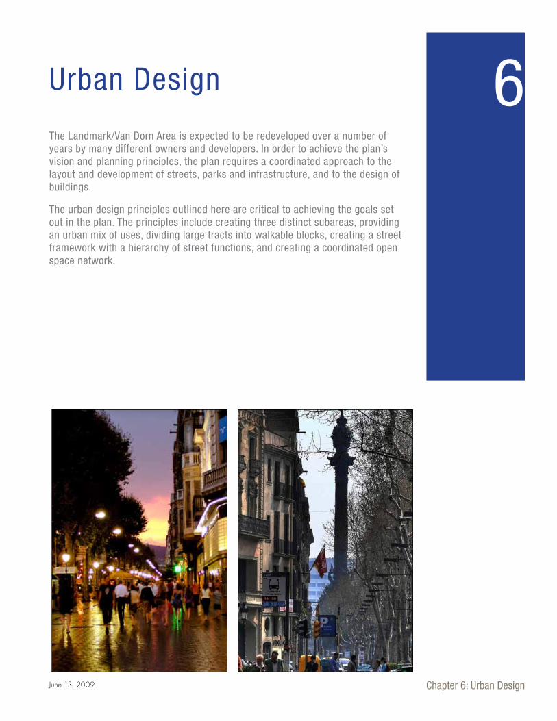
Chapter 6: Urban Design June 13, 2009 Urban Design 6 The Landmark/Van Dorn Area is expected to be redeveloped over a number of years by many different owners and developers. In order to achieve the plan’s vision and planning principles, the plan requires a coordinated approach to the layout and development of streets, parks and infrastructure, and to the design of buildings. The urban design principles outlined here are critical to achieving the goals set out in the plan. The principles include creating three distinct subareas, providing an urban mix of uses, dividing large tracts into walkable blocks, creating a street framework with a hierarchy of street functions, and creating a coordinated open space network.
Transcript
Chapter 6: Urban DesignJune 13, 2009
Urban Design 6The Landmark/Van Dorn Area is expected to be redeveloped over a number of years by many different owners and developers. In order to achieve the plan’s vision and planning principles, the plan requires a coordinated approach to the layout and development of streets, parks and infrastructure, and to the design of buildings.
The urban design principles outlined here are critical to achieving the goals set out in the plan. The principles include creating three distinct subareas, providing an urban mix of uses, dividing large tracts into walkable blocks, creating a street framework with a hierarchy of street functions, and creating a coordinated open space network.
102 |
6.2. Creating New Blocks – Urban Street Grid
An important role of the street grid is to create
appropriate-sized blocks. Block dimensions are of
critical importance because they establish the physical
parameters and conditions for appropriate development.
Development in a pattern of blocks provides for incre-
mental redevelopment as conditions change.
The Plan requires that wherever permitted by site condi-
tions, blocks are to be limited to a maximum length of
350 to 500 feet and a maximum width of 300 feet. Block
dimensions are of critical importance because they set
up the physical parameters and conditions for appropri-
ate development. The blocks created with the street grid
establish the framework for a quality street environ-
ment which also enables pedestrian-scale buildings and
streetscapes. The streets will have generous sidewalks,
street furniture, and pedestrian-scale street lights. The
blocks are oriented with the long dimension on Van
Dorn Street and Duke Street to provide the opportunity
for continued and varied uses and building types. Most
interior neighborhood blocks are oriented east to west,
following the contours of terrain. The blocks in the West
End Town Center are configured to incorporate larger
building footprints for large anchor stores and typical
office building floor plates.
A series of design principles resulted from the analysis of the planning area which are intended to guide future development in the Landmark/Van Dorn corridor. These principles define Landmark/Van Dorn’s place and role in the City and at a more localized level, what the place should look and feel like within its neighborhoods, blocks and streets. They lay out the concept for the pedestrian environment, and for public access to and the experi-ence of the public open spaces. This chapter establishes the principles to guide the trans-formation of an automobile-dominated landscape into sustainable, mixed-use neighbor-hoods and districts that each have distinctive character, are well connected to the city at large via transit, and that offer residents, workers, shoppers and other visitors a human-scaled, pedestrian-oriented environment.
West End Town Center
Pickett Place
Van Dorn Metro
Figure 6-1. Three distinct districts were identified within the planning area in community workhsops. This diagram summarizes the common design features from three breakout groups. All three groups emphasized the importance of linkages across Duke Street and linking the Van Dorn Metro to the rest of the planning area.
6.1. Urban Design Principles
| 103
Chapter 6: Urban DesignJune 13, 2009
Metro, in order to create convenient access to this major
transportation asset.
At its simplest, the proposed street grid consists of two
new north-south streets that run parallel to Van Dorn
Street, a new east-west retail street for Pickett Place
that runs perpendicular to Van Dorn Street, and a new
east-west shopping street in Landmark Mall that runs
parallel to Duke Street. Additional streets supplement
this framework at regular intervals to provide conve-
nient connections and pedestrian access throughout the
planning area. The grid also includes reconfiguring the
right-of-way along Duke Street and Van Dorn Street to
create new boulevards that are more visually attractive,
The plan includes a compact framework for streets that
promotes walkability, creates convenient access to the
Landmark Mall site, and provides for a multi-modal
transportation system. The street framework includes
two important bridge connections – one across Duke
Street to link Landmark Mall with the parcels to the
south of it, and one from Pickett Street to Van Dorn
Figure 6-2. New blocks and existing parcels.
6.3. Street Framework
Figure 6-3. The current street pattern is coarse grained, with large blocks that pose barriers to movement by all travel modes.
104 |
are more comfortable for pedestrians both to walk along
and to cross, and which accommodate improved transit.
Some flexibility will be needed in locating some street
linkages. However, to ensure coordinated development
of streets between property owners and across streets,
certain streets are required to be constructed gener-
ally as shown in Figure 6-6, Street Framework. The
Framework Plan shows New High Street originating in
Landmark Mall and continuing south across Stevenson
Avenue to an ultimate connection with Whiting Street;
the exact location of New High Street between Duke
Street and Whiting Street will be determined during the
development process Whether developed under CCD
zoning or under existing zoning, new development on all
parcels in the planning area is required to accommodate
and provide the street framework. The location of the
remainder of the streets within each block will be evalu-
ated and approved as part of the development approvals
for each block, based on the principles of the plan.
The street framework illustrated shows key elements
and general locations, but is not intended to depict the
details. Detailed engineering analysis will be conducted
at the time of development of each building and block.
Two major infrastructure elements have been recom-
mended to complete the street grid:
Figure 6-4. New north-south parallel streets provide options for local circulation without competing with through traffic on arterial streets.
Figure 6-5. Additional streets are added in areas expected to redevelop to create blocks that have walkable dimensions and human scale.
| 105
Chapter 6: Urban DesignJune 13, 2009
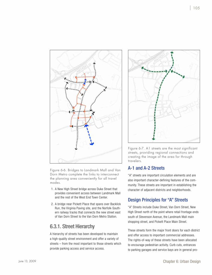
1. A New High Street bridge across Duke Street that provides convenient access between Landmark Mall and the rest of the West End Town Center.
2. A bridge near Pickett Place that spans over Backlick Run, the Virginia Paving site, and the Norfolk-South-ern railway tracks that connects the new street east of Van Dorn Street to the Van Dorn Metro Station.
6.3.1. Street Hierarchy A hierarchy of streets has been developed to maintain
a high-quality street environment and offer a variety of
streets – from the most important to those streets which
provide parking access and service access.
A-1 and A-2 Streets“A” streets are important circulation elements and are
also important character-defining features of the com-
munity. These streets are important in establishing the
character of adjacent districts and neighborhoods.
Design Principles for “A” Streets“A” Streets include Duke Street, Van Dorn Street, New
High Street north of the point where retail frontage ends
south of Stevenson Avenue, the Landmark Mall main
shopping street, and Pickett Place Main Street.
These streets form the major front doors for each district
and offer access to important commercial addresses.
The rights-of-way of these streets have been allocated
to encourage pedestrian activity. Curb cuts, entrances
to parking garages and service bays are in general pro-
Figure 6-6. Bridges to Landmark Mall and Van Dorn Metro complete the links to interconnect the planning area conveniently for all travel modes.
Figure 6-7. A1 streets are the most significant streets, providing regional connections and creating the image of the area for through travelers.
106 |
hibited, and the streets are subject to the highest design
standards.
• Generous sidewalks should be provided, that allow
for wide tree planting zones and space for pedes-
trians, and for bicycles if not provided in the travel
lanes.
• Buildings shall front these streets.
• Main pedestrian building entries shall be located
along “A1” street frontages to the greatest extent
possible.
• Active uses shall be located on all street frontages.
• The highest quality of architectural façade and
streetscape treatment shall be used.
• No permanent curb cuts or service alleys shall
be permitted along “A” street frontages with the
exception of parking structure entrances under
the proposed New High Street bridge or as rea-
sonably required for access or service due to site
constraints.
Design Principles for “B” Streets “B” streets are the secondary streets of each neighbor-
hood. They connect primary streets to each other and
to service streets, and provide access options through
each of the neighborhoods for vehicles, pedestrians and
bicycles. Bicycles are typically accommodated in shared
lanes.
• Buildings shall front the street.
• Active uses shall be located on each street frontage.
• One curb cut per block shall not be exceeded on
both sides of the street.
Figure 6-8. A2 streets are significant community streets, with important image-creating roles within districts and neighborhoods.
Figure 6-9. B and C Streets provide local access and service access. These streets complete the network and provide access to all parcels.
| 107
Chapter 6: Urban DesignJune 13, 2009
• Main building and pedestrian entrances shall be
located along B street frontage unless adjacent to a
higher category street.
• A high quality of architectural façade treatment shall
be used.
Design Principles for “C” Streets “C” streets provide a means of access and service
entries to parking as well as tertiary streets through
the neighborhood. They are the least public in nature
of all of the streets and, therefore, the least restrictive
in design. The “C” streets allow the “A” and “B” street
frontages to function as more public primary streets.
Bicycles use travel lanes.
• Curb cuts, alleys and garage entrances shall be
located on “C” streets.
Figure 6-10. The complete street hierarchy for the Landmark/Van Dorn corridor. Design principles protect functions and help communicate street roles in the heirarchy.
108 |
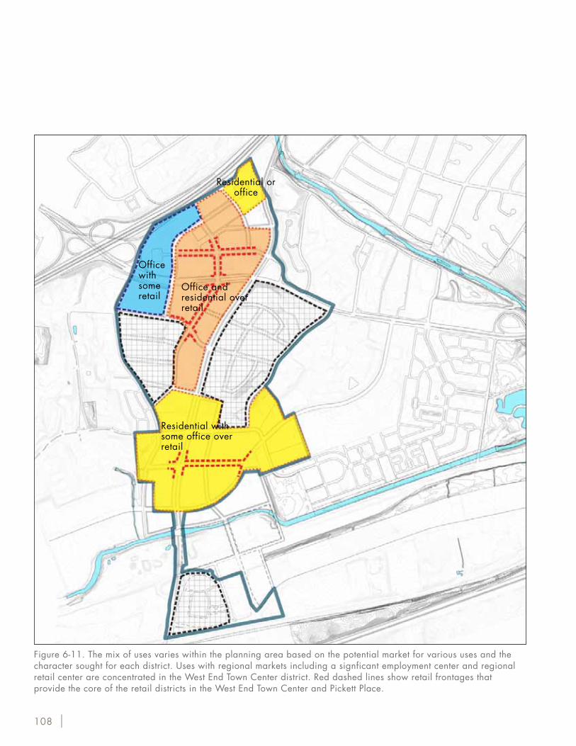
Figure 6-11. The mix of uses varies within the planning area based on the potential market for various uses and the character sought for each district. Uses with regional markets including a signficant employment center and regional retail center are concentrated in the West End Town Center district. Red dashed lines show retail frontages that provide the core of the retail districts in the West End Town Center and Pickett Place.
Office with some retail
Residential or office
Office and residential over retail
Residential with some office over retail
| 109
Chapter 6: Urban DesignJune 13, 2009
There is a regional network of parks with greenway con-
nections within a mile of most parts of the planning area.
These parks and their associated facilities include:
• All Veterans Park (9.6 acres): memorial park, picnic
areas, sitting areas, trails for walking, biking, and
jogging, and a dog exercise area parallel to Pickett
Street.
• Armistead Boothe Park (15 acres): lighted softball /
soccer field, a picnic pavilion with grills, restrooms,
a playground area with play equipment, two tennis
courts, a combination tennis / basketball court, and
pedestrian and bike trials.
• Ben Brenman Park (50 acres): softball field, little
league baseball field, soccer field, tot lot, lake with
gazebo and fountains, restrooms, pedestrian bridges,
picnic pavilion, pedestrian and bike trails, fenced
dog park, and a small amphitheater.
• Brookvalley Park (50 acres): community park, scenic
natural area, biking and walking, playground, exer-
cise area, sitting and picnic areas, ball field, commu-
nity garden plots, and the Bicentennial Tree (oldest
tree in Alexandria). Brookvalley Park is connected by
trail to Holmes Run Scenic Easement to the north, All
Veteran’s Park to the southwest, and Tarleton Park to
the southeast.
• Stevenson Park (9.5 acres): Little League baseball,
lacrosse practice and games, soccer practice, bas-
ketball court, volleyball, playground, sitting area and
park shelter, and summer camp program site.
These parks comprise approximately 134 acres of
parkland for 21,240 people residing in the three census
tracts that encompass Landmark/Van Dorn. This is ap-
proximately 6.3 acres of open space per 1,000 people.
The Open Space Plan recommends a target of 7.5 acres
of open space per 1,000 people.
To ensure an urban character, office, residential and
retail uses are located within each subarea, and are not
built as large, single-use complexes. Mixed-use develop-
ment can substantially reduce vehicle travel compared
to single use complexes, since many trips for conve-
nience goods and services can be made on foot within
the block. With the variety of activities encompassed in
mixed-use areas, street life is sustained throughout the
daytime and evening hours.
While there is a significant concentration of office devel-
opment within the West End Town Center, those uses are
balanced with the retail and residential uses and open
space within the neighborhood.
Figure 6-12. Existing open space. The nearby area includes five City parks with a total area of 134 acres. Holmes Run is a major regional open space corridor, with a multi-use trail connecting to Fairfax County. A similar trail connection is planned for Backlick Run.
§̈¦395
§̈¦495
DUKE STREET
VA
N D
ORN
STR
EET
FAIRFAXCOUNTY
ARLINGTONCOUNTY
FAIRFAXCOUNTY
SEMINARY RO
AD
KING STREET
BRADDOCK ROAD
WA
SHIN
GTO
N S
TREE
T
£¤1
BEAUREG
ARD STREE
T
QU
AK
ER L
AN
E
£¤1
BrookvalleyPark
All VeteransPark
Ben BrenmanPark
ArmisteadBoothe Park
StevensonPark
395
495
Mmetro
EISENHOWER AVENUE
DUKE STREET
Feet2,0001,0000
BRADDOCK ROAD
KING STREET
QU
AK
ER L
AN
E
FAIRFAXCOUNTY
FAIRFAXCOUNTY
ARLINGTONCOUNTY
Mmetro
Mmetro
Mmetro
WA
SHIN
GTO
N S
TREE
T
1
1
VAN
DO
RN S
TREE
T
BEAU
REAGARD
STREE
TSEM
INARY ROAD
495
EISENHOWER AVENUE
Holmes Run
Backlick Run
6.4. A Mixed-Use Development6.5. Creating a Connected
Open Space Network
110 |
Open Space ConnectionsThe Holmes Run Trail is part of a regional multi-use
trail system that runs along Holmes Run from where it
joins Cameron Run in to Fairfax County to the west. The
Holmes Run Trail connects Ben Brenman, All-Veterans
and Brookvalley parks, which form a continuous open
space corridor from Cameron Run to where the trail
crosses under I-395.
Ben Brenman and Armistead Boothe parks are along
Backlick Run. A trail is proposed along Backlick Run in
the Open Space and Trails Master Plan that would con-
nect to a trail system along Turkeycock Run in Fairfax
County. Implementation of this trail system depends on
acquisition or agreements with private property owners
along the run.
Proposed Open Space NetworkAs density is increased and an urban environment is es-
tablished, office, retail and mixed-use areas will require
additional internal open space to maintain human scale
and character. The plan recommends new urban parks
within both the West End Town Center and Pickett Place
to provide nearby public open space for new mixed-use
developments. These parks should be designed primarily
as passive landscaped parks. They have an area ranging
from half an acre to over two acres, and are typically de-
fined on at least three sides by streets. A central “town
green” is also recommended as a space for community
gatherings and civic events for the Landmark Mall site.
Large open spaces and natural areas need to be at the
periphery and in interconnected open space corridors
where they do not break up the critical continuity of
pedestrian-oriented activity.
• Landmark Mall at West End Town Center – an
approximately 3 ½-acre open space network that
extends across the site, with terraced open space
with frontage along Van Dorn Street sloping into the
middle of the site and connecting to the new green
boulevards, open space and squares that incorporate
sustainable design elements. Major features include
Landmark Plaza, the town green central to the site,
and Terrace Garden, connecting to Van Dorn Street.
• New High Street Park – an approximately 0.5 -
1.0-acre of parkland with frontage along Stevenson
Avenue between Van Dorn Street and Walker Street.
The park would provide passive open space for
residents and workers in the area.
• Pickett Square – an approximately one-half-acre
urban square in the heart of the Pickett Place
neighborhood. Modeled after successful active urban
open spaces, the square would be bounded by retail
uses at the ground level with residential uses on the
upper floors.
• Pickett Plaza– approximately one acre of land could
be consolidated with the existing park to expand
the existing Armistead Boothe Park to create park
frontage along Pickett Street. The site is currently
developed with a self-storage facility and a vacant
lot used for storage. Expansion of the park requires
the consent of the property owner, or action on the
part of the City to acquire the land.
• Edsall West Park – an approximately one-acre park
between the proposed extension of Whiting Street
and the South Port apartments to the west. This
potential park provides a connection to a small
drainage course that joins Backlick Run, and could
potentially provide a link to the proposed Backlick
Run trail system.
Implementing this system will require proactive efforts
by the City, including consideration of:
• Collaboration with private owners to facilitate the
creation of New High Street Park, Edsall West Park
and the expansion of Armistead Boothe Park;
• Establishment of an open space fund for developer
contributions to acquire, design and construct
High Street Park, Edsall West Park, Pickett Square
and Pickett Plaza. These contributions would be
| 111
Chapter 6: Urban DesignJune 13, 2009
Pickett Square
Edsall West Park
Pickett Plaza
Terrace Garden
Landmark Plaza
New High Street Park
DUKE STREET
VAN
DO
RN S
TREE
T
EDSALL ROAD
PICKETT STREET
EISEN
HOW
ER AVENUE
Backlick Run
Holmes Run
NEW
HIG
H ST
REET
Figure 6-13. Open Space Plan. A number of small urban parks will provide nearby open space for new mixed-use developments. All areas within new mixed-use developments are within an easy walk of one of these public open spaces.
112 |
required at the time of redevelopment, with rates of
contribution based on expected acquisition costs.
The plan recommends that in all projects 25% of the site
area excluding streets be provided as ground-level open
space. Such open space may be provided above the
ground level or may be reduced with a contribution to
an open space fund if such alternatives better meet the
Plan objectives.
As part of future planning efforts, the plan encourages
the evaluation of the potential reuse of the Virginia
Paving site to meet stormwater management needs and
as an open space asset connecting Backlick Run and the
Clermont Cove property, which is currently on the City’s
open space priority list.
| 113
Chapter 6: Urban DesignJune 13, 2009
in the Landmark/Van Dorn Small Area Plan adopted in
1992. The heights of existing buildings in and near the
planning area are shown in Figure 6-15.
As shown in Figure 6-16, building heights within the
West End Town Center neighborhood are proposed for
a range of 85 to 250 feet. Height ranges have been
proposed within this neighborhood to provide variety in
heights and transition into adjacent areas. Heights rang-
ing from 150 to 250 feet are proposed on the frontage
of Duke Street. Heights up to a maximum of 250 feet are
proposed along I-395 north of Duke Street to allow for a
signature building or complex at this prominent gateway
location. All building heights within this neighborhood
will be subject to approval through the development
special use permit (DSUP) process, with varied heights,
The heights of buildings, site coverage, and the
character of building tops define the skyline of each
neighborhood from a distance. The width of streets from
building face to building face, building stepbacks, and
the continuity of the setback and street wall establish
the character of each neighborhood. The character and
articulation of the facades refine the street character at
the individual block and pedestrian level.
Figures 6-14 and 6-16 show the existing and proposed
building height limits in feet within the planning area
and nearby areas. The existing height limits are derived
from the existing zoning designations. In the case of the
Commercial Residential Mixed Use Medium and High
(CRMU-M and CRMU-H) Districts, the existing zoning
calls for building heights to conform to the limits set
6.6. Density and Massing
Planning Area
77 (150) 150
50
77 (150)
50
50 (77)
150
50
150
50
45,55-77-120
45
15(30-40)
5050(77)
77 (150)
35 (50)
100 (150)
15(30-40)
15(30-40)
50(77)
5050
150
77 (150)
35 (50)100 (150)
100(150)
35
15 (30-40)
45
45
45
Existing Height Limits( ) with Special Use Permit
50
150
150
VAN
DO
RN S
TREE
T
DUKE STREET
PICKETT S
TREE
T
0 500 1,000Feet
Figure 6-14. Building heights permitted by existing zoning in and near the planning area. A height of 150 feet is now permitted in most of the West End Town Center area.
141151
12469 50
100
137
155 116
77
150160
123
117
80 143139
56
64
44
36
31
24
39
31
31
42
150
77
59
67
6066
105
121140
143
6769
147149
147
55
2439
30
717363
5757
45
107
512719
18
44
3933
31 35
2430
24-3327-46
42 11
39
3145
38-45
2172
2626
2618
3415
24
27
20
2924
27
2326
4262
40-50
20
50-54
50
52-5629-41
3120
3518
7960
51-63
7933
37
25-306624
36-52
4838
3021
212329
41-48
30-39 139
25-45
70
2721
262417 19
15
2327
1815
3533 40
29
2316
Existing BuildingHeight in Feet
Heights based on aerial photo-graphy. May not matchheight as defined in ZoningOrdinance.
150+ 100-15050-100<50
DUKE STREET
VAN
DO
RN S
TREE
T
EDSALL ROAD
PICKE
TT S
TREE
T
STEVENSON AVENUE
I-395
Feet1,0005000
Figure 6-15. The heights of existing buildings in the planning area and immediate surroundings are shown, with buildings more than 100 feet tall shown in orange. All existing buildings taller than 100 feet are residential.
114 |
transitions, and high quality architecture being required.
Exceptional architectural design and building quality will
be required for the taller signature buildings.
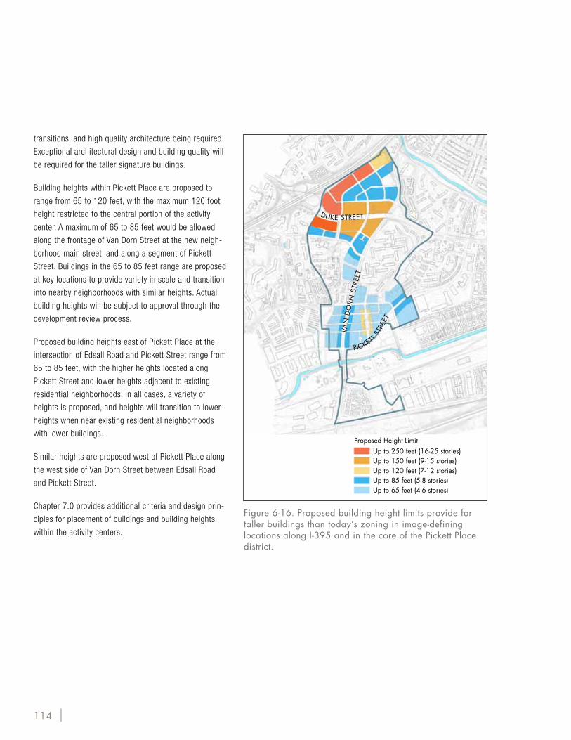
Building heights within Pickett Place are proposed to
range from 65 to 120 feet, with the maximum 120 foot
height restricted to the central portion of the activity
center. A maximum of 65 to 85 feet would be allowed
along the frontage of Van Dorn Street at the new neigh-
borhood main street, and along a segment of Pickett
Street. Buildings in the 65 to 85 feet range are proposed
at key locations to provide variety in scale and transition
into nearby neighborhoods with similar heights. Actual
building heights will be subject to approval through the
development review process.
Proposed building heights east of Pickett Place at the
intersection of Edsall Road and Pickett Street range from
65 to 85 feet, with the higher heights located along
Pickett Street and lower heights adjacent to existing
residential neighborhoods. In all cases, a variety of
heights is proposed, and heights will transition to lower
heights when near existing residential neighborhoods
with lower buildings.
Similar heights are proposed west of Pickett Place along
the west side of Van Dorn Street between Edsall Road
and Pickett Street.
Chapter 7.0 provides additional criteria and design prin-
ciples for placement of buildings and building heights
within the activity centers.
Up to 250 feet (16-25 stories)Up to 150 feet (9-15 stories)Up to 120 feet (7-12 stories)Up to 85 feet (5-8 stories)Up to 65 feet (4-6 stories)
Proposed Height Limit
VAN
DO
RN S
TREE
T
DUKE STREET
PICKETT S
TREE
T
Figure 6-16. Proposed building height limits provide for taller buildings than today’s zoning in image-defining locations along I-395 and in the core of the Pickett Place district.
| 115
Chapter 6: Urban DesignJune 13, 2009
6.7.1. General Principles• Create compact pedestrian-friendly mixed-use
neighborhoods.
• Organize development by a modified orthogonal grid
nections to the Town Center at Walker Street, at the
BJ’s Site, and at the Van Dorn/ Duke Street cross-
ing; and create smaller, walkable blocks at the BJ’s,
CompUSA and Safeway sites
• Create smaller, walkable blocks between Edsall Road
and Pickett Street
• Connect to Holmes Run by using a green spine that
links through the Town Center, and takes advantage
of viewsheds to the south
• Create a central main street that connects Van Dorn
with Pickett
• Create new urban parks within each of the districts
of the plan and connect to the citywide system of
open space and natural corridors.
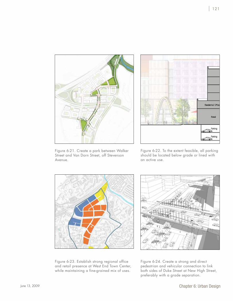
• Create a park between Walker and Van Dorn, off
Stevenson Avenue
• Create a “four corners” retail intersection at Van
Dorn and the new Pickett Place Main Street
• To the extent feasible, all parking should be located
below grade or lined with an active use
• Plan for a new street connection from Pickett Place
to Van Dorn Metro
• Leverage high visibility along Duke Street and I-395
by creating distinctive skylines and building tops
along both major arterials
• Create a central gathering place or Town Green
within the West End Town Center.
• Establish strong regional office and retail presence
at West End Town Center, while maintaining a fine-
grained mix of uses
• Create a strong and direct pedestrian and vehicular
connection to link both sides of Duke street, prefer-
ably with a new vehicular and pedestrian bridge on
New High Street.
Van
Dor
n St
reet
Duke Street
6.7. Summary of Urban Design Principles
116 |
6.7.2. Strategies for Areawide Organizing Features Establish Van Dorn Street and Duke Street as Tree-lined Transit Boulevards
Tree-lined boulevards with broad medians provide a
strong organizing element to the areas through which
they pass. The boulevard’s character ties areas along it
together and gives them a shared identity. The boulevard
can humanize the hostile environment of high-capacity
roadways and create a much more appealing front door
to the community.
Van
Dor
n St
reet
Duke Street
| 117
Chapter 6: Urban DesignJune 13, 2009
Establishing a sense of place and unique identity is
important to creating a feeling of being in a particu-
lar neighborhood or community. This uniqueness and
identity can be encouraged by giving each neighbor-
hood identifying features in its public areas and open
spaces, by creating a different feel to each area through
proportions of streets and buildings, and development of
unique character particularly at gateway locations with
architectural features and public art.
Create a distinctive character for each neighborhood and district within the planning area
118 |
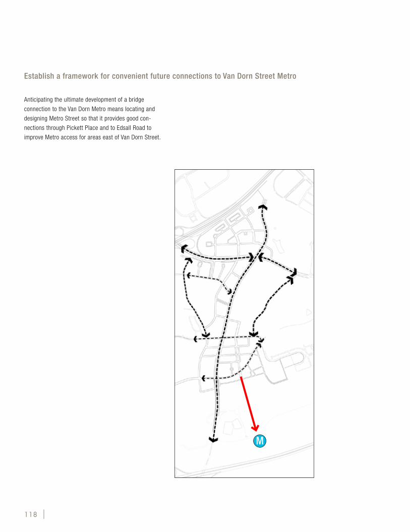
Anticipating the ultimate development of a bridge
connection to the Van Dorn Metro means locating and
designing Metro Street so that it provides good con-
nections through Pickett Place and to Edsall Road to
improve Metro access for areas east of Van Dorn Street.
Establish a framework for convenient future connections to Van Dorn Street Metro
M
| 119
Chapter 6: Urban DesignJune 13, 2009
These natural features provide identify and connected-
ness for the entire planning area to other natural areas
throughout Alexandria and into surrounding areas of
Fairfax County. Backlick Run in particular is underutilized
as a natural asset today. Its long-term potential for open
space, trails and potential stream restoration for storm-
water quality enhancement and natural habitat should be
further evaluated.
Enhance and connect the area’s natural assets, such as Holmes Run and Backlick Run
120 |
6.7.3 Urban Design Principles for West End Town Center
Figure 6-17. Establish convenient, multi-modal, at-grade connections to the Town Center at Walker Street, at New High Street, and at the Van Dorn Street bridge over Duke Street. Create smaller, walkable blocks at the Saul Centers/Passport, Choi and Van Dorn Plaza sites.
Figure 6-18. Connect to Holmes Run by using a green spine that links through the Town Center, and takes advantage of viewsheds to the south.
Figure 6-19. Leverage high visibility along Duke Street and I-395 by creating distinctive skylines and building tops along both major arterials.
Figure 6-20. Create a central gathering place within the Town Center for Alexandria's West End
| 121
Chapter 6: Urban DesignJune 13, 2009
Figure 6-21. Create a park between Walker Street and Van Dorn Street, off Stevenson Avenue.
Figure 6-23. Establish strong regional office and retail presence at West End Town Center, while maintaining a fine-grained mix of uses.
Figure 6-24. Create a strong and direct pedestrian and vehicular connection to link both sides of Duke Street at New High Street, preferably with a grade separation.
Figure 6-22. To the extent feasible, all parking should be located below grade or lined with an active use.
122 |
Figure 6-25. West End Town Center. This view looks toward the west from along the main shopping street in West End Town Center. Landmakr Plaza is the open square on the right, with tall buildinga along I-395 past the plaza. Retail frontages line the main street, with office buildings and residences stepped back above.
| 123
Chapter 6: Urban DesignJune 13, 2009
Figure 6-26. West End Town Center, looking east along Duke Street by the New High Street Bridge. The Van Dorn Street bridge is visible near the top of the rendering. The bridge connecting the north and south sides of Duke Street at New High Street is an important link to make the north and south sides of the Town Center function as a single place. Transit on the bridge is connected to transit on Duke Street below.
124 |
Figure 6-27. New High Street Park. This scene shows the view up New High Street from south of Stevenson Avenue with the taller buildings at Duke Street in the distance and buildings framing the park on Stevenson Avenue and New High Street.
| 125
Chapter 6: Urban DesignJune 13, 2009
This district includes the part of the Plan area between
Edsall Road and Pickett Street, and includes several par-
cels on either side of Van Dorn Street, the major arterial
that serves this area, that are likely to re-develop in the
near term. The proximity to existing developments such
as Cameron Station and the EOS-21 apartments, the
natural resource of Backlick Run along with the commu-
nity’s vision for the sub-area present an opportunity to
develop an “Urban Village” that is distinct from the West
End Town Center to the north. This urban village will
be centered on a Main Street that forms a retail spine,
and have good access, in the future, to a recovered and
enhanced Backlick Run. A compact street grid, created
by adding three new streets, along with well-integrated
retail uses and open spaces will give special character
to West End’s new urban village. The Pickett Place dis-
trict is imagined as a mixed-use community center, de-
veloped to a lower intensity than the town center further
north, but is still a magnet for residents of and around it.
A new Main Street forms the spine for this district, while
a new north-south Metro Street will eventually link to a
bridge over Backlick Run and the Norfolk Southern rail
line.
Figure 6-28. Create smaller, walkable blocks between Edsall Road and Pickett Street.
Figure 6-29. Create a central main street that connects Van Dorn Street with Pickett Street.
Figure 6-30. Plan for a new street connection from Pickett Place to Van Dorn Metro.
Van
Dorn
Stre
et
Pickett Street
Edsall Road
Van
Dorn
Stre
et
Pickett Street
Pickett Place Main Street
6.7.4. Urban Design Principles for Pickett Place
M
126 |
Figure 6-31. Pickett Place Main Street at Pickett Square. Looking east along Pickett Place Main Street, the wide median park of Pickett Square is visible. Retail buildings line the main street, while a tall residential building with retail use on the ground floor fronts Pickett Square.