Urban Heat Island in Hong Kong Department of Architecture, Chinese University of Hong Kong Page 1 of 24 A Position Paper Urban Heat Island in Hong Kong AN Xipo Edward NG REN Chao 01 JAN 2007
Transcript
Urban Heat Island in Hong Kong
Department of Architecture, Chinese University of Hong Kong Page 1 of 24
A Position Paper
Urban Heat Island in Hong Kong
AN Xipo Edward NG REN Chao
01 JAN 2007
Urban Heat Island in Hong Kong
Department of Architecture, Chinese University of Hong Kong Page 2 of 24
Introduction
This is a summary report of a study to investigate Urban Heat
Island (UHI) in Hong Kong. It is aimed at ‘decision makers’-
planners, architects, urban designers, developers and public
health care professionals and help them to take more
consideration regarding to UHI in urban planning.
Hong Kong possesses oceanic sub-tropical climate. Hotness,
humidity and thermal discomfort are main characteristics of the
weather in most days of the year and in the context of global
warming, Hong Kong experiences hotter climate than before.
In a Hong Kong Observatory technical report, it is found that
the annual mean temperature is increasing at a rate of 3.5 ◦C per
year in the recent 20 years and the number of cold days is
decreasing at a rate of 0.3 day per year in the recent 100 years.
The UHI effect is one of the reasons accounting for such local
climate change.
Hong Kong is particularly vulnerable to high summer
temperatures – our homes, workplaces, public buildings, public
realm and transportation vehicles are equipped with air
conditioning, which contribute to the urban heat conditions.
Hot weather places additional stress on the body, raising health
risks for the vulnerable and increasing discomfort for everyone.
Every 1 degree rise in outdoor temperature means at least 6%
increase in energy costs. Hong Kong’s growth over the next
decade needs to ensure that new development is located,
designed and constructed to minimize, and if possible, reduce
its contribution to Hong Kong’s urban heat island.
Urban Heat Island in Hong Kong
Department of Architecture, Chinese University of Hong Kong Page 3 of 24
What is the Urban Heat Island?
Urbanization is the growth of the proportion of the population living in
urban areas. The world is experiencing unprecedented urban growth.
Only 3% of the world’s population lived in urban areas in 1800 and
this figure increased to 14% and 47% in 1900 and 2000. The rapid
urbanization and the emergence of many mega cities trigger a number
of environmental issues. The Urban Heat Island is one of the effects of
urbanization. The UHI refers to the phenomenon that the temperature
in the urban place is always higher than that in surrounding rural areas,
especially at calm and cloudless night. Figure 1 illustrates an idealized
heat island profile for a city, showing temperatures rising from the
rural fringe and peaking in the city centre. The profile also
demonstrates how temperatures can vary across a city depending on
the nature of the land cover, such that urban parks and lakes are cooler
than adjacent areas covered by buildings.
According to Landsberg [1], Urban Heat Island, as the most obvious
climatic manifestation of urbanization, can be observed in every town
and city, such as New York, Washington, Tucson, Phoenix, Mexico
City, Tokyo and Shanghai etc.
The urban heat island is mainly caused by the storage of solar energy
in the urban fabric during the day and release of the energy into the
atmosphere at night. The process of urbanization and development
alters the balance between the energy from the sun used for raising the
air temperature (heating process) and that used for evaporation
(cooling process).
The strength of the urban heat island is measured by the ‘urban heat
island intensity’, which describes the maximum difference in
temperature between urban and rural locations within a give time
Urban Heat Island in Hong Kong
Department of Architecture, Chinese University of Hong Kong Page 4 of 24
period. The highest values of the urban heat island intensity, in the
region of 3-8 ◦C, are often reached between about 11 o’clock at night
and 3 o’clock in the morning (Figure 2). This is why the urban heat
island is often referred to as a nighttime phenomenon. UHI intensities
are also greater in summer than winter because of
Figure 1. Sketch of an Urban Heat Island profile (source http://eande.lbl.gov/HeatIsland/HighTemps/)
contrasts in the amount of energy received from the sun, which
is absorbed by the urban surface during the day and released at
night. The urban heat island keeps Hong Kong warmer in
winter. This could be one additional reason explaining the
decreasing cold days within the whole year, besides the
contextual greenhouse effect that the annual mean temperature
is increasing. Besides, the UHI is found to have a relationship
with the urban population, as shown in Figure 3.
The heat island effect is welcomed in short winter in Hong
Kong will increase the city temperature, make the citizens
comfortable and decrease the energy consumption for heating.
Anyhow, Hong Kong lies in the sub-tropical region and
Urban Heat Island in Hong Kong
Department of Architecture, Chinese University of Hong Kong Page 5 of 24
experiences a very long hot and humid summer so that in such
case the heat island effect is a negative effect. The planners,
architects, urban designers and developers should keep in mind
that the urban heat island intensities should be mitigated and
planning and construction should not deteriorate the heat
condition.
0 3 6 9 12 15 18 21 24-4
-3
-2
-1
0
1
2
3
4
H ong Kong loca l tim e(H r)
Urb
an H
eat I
slan
d In
tens
ity (°
C)
Figure 2. The variation in UHI intensity for Hong
Kong over 24 hours for Autumn 2006. The
temperature taken from Hong Kong Observatory
station is used as the urban temperature while that
taken from Ta Kwu Ling station is used as the rural
temperature. (courtesy HKO)
Figure 3. The UHI’s linear relationship with the
urban population
Urban Heat Island in Hong Kong
Department of Architecture, Chinese University of Hong Kong Page 6 of 24
Urban Heat Island Studies around the world:
Firstly discovered by Luck Howard [2], the UHI has attracted much
attention of the researchers around the world.
In Europe, various studies on the intensity of the UHI have been done
for many cities. A daily upper docile limit of 3.1◦C was reported by
Chandler [3] in a comparison of Kensington and Wisley over a period
of ten years. Lyall [4] observed the average magnitude of the nocturnal
heat island effect was 2.5 ◦C in June and July in London. An average
UHI intensity of around 7◦C was found by Barring [5] during the
winter and spring seasons in Malmo, Sweden and the UHI intensity
observed in Essen, Germany by Swaid and Hoffman [6] was between 3
to 4 ◦C for both day and night time.
In North America, there are also lots of studies of UHI carrying on in
many cities. In 1997, the Environmental Production Agency (EPA)
instituted the “Heat Island Reduction
Initiative” (HIRI) in the wake of the heat wave that struck Chicago in
July 1995, resulting in a death toll of over 700 people [7]. As part of
this initiative, the “Urban Heat Island Pilot Project” (UHIPP) was
launched in 1998 to investigate the UHI effect, raise public awareness
of the issue, and quantify the effects of mitigation measures [8].
Subsequently, five cities have been selected for inclusion: Baton
Rouge, Chicago, Houston, Sacramento, Salt Lake City.
Urban Heat Island in Hong Kong
Department of Architecture, Chinese University of Hong Kong Page 7 of 24
In Asia, numerous studies on the UHI have also been done in some
countries. Chow [9] reported the magnitude of the urban heat island
effect in Shanghai, China. A systematical study on UHI was carried in
Singapore [10]. In many cities in Japan, such as Tokyo, Kobe, Osaki
etc, studies on UHI were carried on as well. Strategies as well as
guidelines that mitigate the UHI intensity were proposed. For example,
network of water, green space and wind paths along the Meguro river
in Shinagawa was proposed in order to mitigate the UHI effect, as
illustrated in Figure 4.
Figure 4. Proposed measures to mitigate the UHI effect in Shinagawa (source http://www2.city.shinagawa.tokyo.jp/jigyo/05/bijyon_s.pdf)
Urban Heat Island in Hong Kong
Department of Architecture, Chinese University of Hong Kong Page 8 of 24
What is the Evidence for Hong Kong’s Urban Heat Island? According to the technical report of Hong Kong Observatory, due to
the greenhouse effect, the world is getting warmer and warmer in the
last century. In the context of global warming, Hong Kong experiences
a higher temperature increase, i.e., the mean temperature of the Hong
Kong has increased 1.8 ◦C while that of the entire earth has increased
0.6 ◦C through the last century [4], which could be illustrated in Figure
5. The UHI effect is thought to be the main reason causing the
difference. However, studies of Hong Kong UHI were not so many
that some data, for example, the spatial and temporal distribution of the
UHI intensity is not clear, and the dominant factors, which result in the
Hong Kong UHI, also need further research as the topography, climate
and city structure is different with those cities studies before. Hence
further detailed research about detection and characteristic of Hong
Kong UHI is imperative. There are three prevailing approaches
detecting the UHI. One is using the historical Hong Kong Observatory
data.
The HKO stations record accurate temperature and other weather data,
but there are only limited stations and they cannot provide the spatial
distribution of the UHI over the whole city.
The second approach is to employ the remote sensing technology.
According to J.A. Voogt and T.R. Oke [16], thermal remote sensors
can observe the surface UHI since they ‘see’ the spatial patterns of
upwelling thermal radiance. Studies that have applied thermal remote
sensing to study of UHI have been well summarized by them. An
example of such UHI image is shown in Figure 6. In Hong Kong, Prof
J. Nichol et al. have utilized the ETM+ satellite images to investigate
the UHI and proved this technology an useful technology to study the
Urban Heat Island in Hong Kong
Department of Architecture, Chinese University of Hong Kong Page 9 of 24
UHI. Spatial distribution of the UHI and the effect of building structure
and material could be derived from remote sensing image, as shown in
Figure 7 [11].
Figure 5. Annual mean temperature anomalies globally and at Hong Kong Observatory Headquarters (courtesy HKO)
Figure 6. Relative temperature derived from thermal band of Landsat-7 ETM+ satellite (Singapore – courtesy N H Wong)
Urban Heat Island in Hong Kong
Department of Architecture, Chinese University of Hong Kong Page 10 of 24
The third approach uses grounded-based measurements. Fixed weather
stations or moving vehicles can provide usable data on the ground. By
taken consideration of the neighbourhood conditions, such as the
surface albedo, sky view factor, green area, wind condition etc, it is
also possible to investigate the causing factors which result in the UHI
in certain area [17].
Besides the UHI, another term named as Physiological Equivalent
Temperature (PET) [12] is used to describe the effective temperature,
which considers all the environmental factor, such as temperature,
solar radiation, wind speed, humidity etc. It is an effective thermal
index for the urban planners and architects to evaluate the
environmental condition. An example of the PET distribution in Hong
Kong with 1km*1km resolution is shown in Figure 8.
Figure 7. UHI distribution in Wan Chai, derived from the satellite remote sensing images. (courtesy J. Nichol)
Urban Heat Island in Hong Kong
Department of Architecture, Chinese University of Hong Kong Page 11 of 24
Figure 8. Distribution of calculated PET in Hong Kong , in Jan (left)
and July (right). (source: Prof A. Matzarakis)
Figure 9. Total daily deaths in London, by age group in 2003. The
peak in deaths is coincided with the August heat wave
Urban Heat Island in Hong Kong
Department of Architecture, Chinese University of Hong Kong Page 12 of 24
What are the Environmental & Socio-Economic Consequences of the Urban Heat Island?
Hong Kong lies at the latitude of 22°17'N and has sub-tropical oceanic climate. The
temperature in most days of the year is higher than the human thermal comfortable
temperature. The UHI additionally increases the urban temperature. UHI in winter, is
a welcome effect in some extent, however inversion layers may form due to the UHI
effect. Ascending warm air current created from warm urban areas are trapped under
inversion layer that exacerbate air pollution [18]. Higher urban temperature make the
people feel uncomfortable and boost demand in more energy consumption for air
conditioning. Increasing of the urban temperature by 1 °C may result in 2% to 3% in
increase of energy consumption. During the last 40 years, it can be assumed that 3%
to 8% of the current urban electricity demand is used to compensate for the heat-
island effect alone [19]. Recent research conducted by National Aeronautics and
Space Administration (NASA) also reveals that the UHI will also lead to increasing of
the rain fall around the cities [20].
In addition, the UHI will also have significant socio-economic consequences. The
UHI deteriorate the urban temperature in extreme hot weather conditions and may
lead to increase of mortality. A case example is that during the summer of 1999, a
heat wave occurred in the mid-western and eastern United States. This period of hot
and humid weather persisted from July 12 through August 1, 1999, and caused or
contributed to 22 deaths among persons residing in Cincinnati (18 deaths) and Dayton
(4 deaths) [21]. Another example is the sudden increase of mortality in London in
Summer, 2003, when in which time the heat wave occurs. Especially the elder people
are much more vulnerable to the extreme heat condition. As shown in Figure 9, the
sudden increase of mortality, especially the elder mortality, coincides with the heat
wave in 2003. Taken consideration of all the impacts mentioned above, it can be
concluded that the UHI is a negative effect more than a positive effect in Hong Kong.
Urban Heat Island in Hong Kong
Department of Architecture, Chinese University of Hong Kong Page 13 of 24
What is the Principal Causes of the Urban Heat Island?
The UHI is an ‘inadvertent’ modification of the climate, caused by
changes to the form and composition of the land surface and
atmosphere. When a land cover of buildings and roads replaces green
space, the thermal, radiative, moisture and aerodynamic properties of
the surface and the atmosphere are altered. This is because urban
construction materials have different thermal (heat capacity and
thermal conductivity) and radiative (reflectivity and emissivity)
properties compared to surrounding rural areas, which results in more
of the sun’s energy being absorbed and stored in urban compared to
rural surfaces. In addition, the height of buildings and the way in which
they are arranged affects the rate of escape at night of the sun’s energy
absorbed during the day by building materials. The result is that urban
areas cool at a much slower rate than rural areas at night, thus
maintaining comparatively higher air temperatures. Urban areas also
tend to be drier than their rural counterparts because of the lack of
green space, a predominance of impervious surfaces and urban
drainage systems, which quickly remove water from the urban surface.
This combination of effects alters the energy balance of the urban
environment. Consequently in urban compared to rural areas, more of
the sun’s energy absorbed at the surface goes into heating the
atmosphere and thus raising the air temperature than into
evapotranspiration (water uptake and loss by plants), which is a
cooling process.
Urban Heat Island in Hong Kong
Department of Architecture, Chinese University of Hong Kong Page 14 of 24
According to Oke et al [22], those important factors influencing the UHI include:
• Canyon radiative geometry decreases the long-wave radiation loss from street
canyons since the complex exchange between buildings and the screening of
the skyline. It could be graphically illustrated in Figure 10. Owing to this
reason, the UHI intensity is correlated with the geometry of the urban canyon,
as expressed by the relationship between the building’s height (H) and the
distance between them (Width), namely the ratio: (H/W) [14]:
dTmax=7.45+3.97*ln(H/W)
Figure 10. Schematic distribution of the impinging solar radiation in open-flat country, built-up areawith H/W ratio of about 1 and high-density urban area with H/W ratio of about 4, revealing that more reflected radiation energy is stored within the canopy layer for higher H/W ratio case.
Figure 11. Typical Hong Kong buildings with high stores and high H/W ratio
Urban Heat Island in Hong Kong
Department of Architecture, Chinese University of Hong Kong Page 15 of 24
or alternatively, the urban hemispheric height-to distance ration, as seen from
a given point, can be expressed by the “sky view factor”:
dTmax=15.27-13.88*SVF
We believe this is the main reason for the UHI in
Hong Kong. Typical buildings in Hong Kong possess
high stories and the width between buildings is
narrow, i.e., the buildings have high H/W ratio, as
illustrated in Figure 11. On one side, this kind of
geometry stores more heat in the day time than the
buildings with low H/W ratio. On the other side, such
wind-blocking buildings will block the prevailing
wind, reduce the wind speed and deteriorate the urban
air ventilation. This is why the Planning Department
of Hong Kong initiates the project on “ Air
Ventilation Assessment in Hong Kong” , which is
coordinated by Prof E. Ng [23].
• Thermal properties of materials increase sensible heat gain during the daytime
and release it back into urban environment at night. These materials also
replace soils or plants which are naturally cooling means in cities.
• The loss of evaporating surfaces transfers more energy into sensible heat
rather than latent heat in cities.
• Anthropogenic heat released from vehicles, stationary sources or animal
metabolism increases ambient air temperatures in cities.
• The urban greenhouse effect incurs more incoming long-wave radiation gain
from the polluted urban environment.
• Reduced turbulent transfer of heat from within streets.
Urban Heat Island in Hong Kong
Department of Architecture, Chinese University of Hong Kong Page 16 of 24
What are the Options for Managing the Urban Heat Island?
Policies designed to mitigate the UHI may need to balance the need to
manage heat at the building, neighbourhood and city scales, talking
into account the nature of development (new versus existing) and be
conscious of what is achievable in reality. Furthermore, the climate of
Hong Kong is changing because of alteration to global-scale climate
processes. This has implications for the planning and design and
current and future urban developments from the local to city scale.
Urban designers and planners need to acknowledge this, and in doing
so base design criteria on data that describes the current and projected
future climate of Hong Kong, and be especially aware of the critical
importance of minimum temperature for human thermal comfort,
health and patterns of energy consumption.
As mentioned in the previous section, the principal causes of the UHI
are the storage by day of solar energy in the urban fabric and release of
this energy into the atmosphere at night, and the fact that the process of
urbanization alters the balance between the energy from the sun used
for raising the air temperature and that used for evaporation. The urban
buildings’ geometry, construction material (which affects the effective
albedo, thermal capacity and conductivity), decrease of plants and
vegetation are account for this effect. In addition, anthropogenic heat
could become an important future contribution of energy for the
development of the UHI, depending on energy consumed in air
conditioning/heating for example The future construction and planning
strategies that will mitigate the UHI should consider every aspect
according to the main causes of the UHI.
Urban Heat Island in Hong Kong
Department of Architecture, Chinese University of Hong Kong Page 17 of 24
In developing mitigation strategies for Hong Kong’s UHI, it must be
kept in mind that the UHI is a city scale phenomenon and the outcome
of the combination of the vast range of microclimates that exist across
Hong Kong. Further, as the built components of the urban system
occur at different scales (e.g., individual building to industrial park to
major industrial zone) any physical alteration of these will have
climate impacts at different scales. Consequently the link between UHI
management policy and urban climate scale needs to be acknowledged.
To manage Hong Kong’s UHI form and intensity would require the
alteration of existing land cover characteristics for large areas of
central Hong Kong. From a practical point of view this is not possible.
However there are opportunities to change microclimates and therefore
manage climates at the street canyon to neighborhood scale. Over time
the cumulative effects on UHI form and intensity of a staged
programme of local scale climate modification could be significant.
Effective strategies that can be implemented within the context of the
existing urban structure and have impacts at the local and near local
scale include cool roofs, green roofs, planting trees and vegetation and
cool pavements.
Cool roofs & walls: Roofs and walls in color (the albedo of which are
usually lower than that of light color materials) and will probably reach
temperature of 50-60 ◦C on hot sunny days. The stored energy will be
released to the urban atmosphere and is the major resource contribution
to the UHI. The higher the temperature of these roofs and walls is, the
higher the UHI intensity will be. The heat of the buildings’ surface will
also transfer into inside of the building, causing higher energy
consumption for air conditioning. In addition, higher temperature of
roofs and walls will also accelerate the deterioration of the construction
materials. In contrast, roofs and walls built with materials with light
color, high reflectance/albedo and low heat capacity in future building
Urban Heat Island in Hong Kong
Department of Architecture, Chinese University of Hong Kong Page 18 of 24
construction are welcome. They will strategically change the effective
albedo of the whole city.
Cool Pavements: Like many of Hong Kong’s roofs, the streets and to
a lesser extent, the pavements of Hong Kong are typified by dark
surfaces. The employment of ‘cool pavements’ comprised of material
with high solar reflectivity and good water permeability is potentially a
very effective way of mitigating high urban temperatures through
decreasing absorption of solar energy and encouraging water storage in
the urban surface and thus evaporative cooling. The high albedo roads
and pavements may have benefits for nighttime street lighting. For
Hong Kong, discernible climate impacts of cool pavements could be
achieved for large parking areas, terminal facilities, air ports and urban
roadways with large expanses of paved surfaces when re-surfacing or
new surfacing is planned.
Planting Trees and Vegetation: ‘Urban Greening’ would be the most
cost-effective way of ameliorating harsh urban climates at the
individual building to neighborhood scale. Trees and vegetations are
good climate modifier due to the following three reasons: 1They
provide shade, which reduces the temperature by 5-20 ◦C, compared to
the places with solar radiation and provide better outdoor thermal
comfort environment. Trees planted along the roads will have
significant impact reducing the temperature of road, as mentioned in
the last paragraph, which is a big factor causing the UHI.
2 Water is easier to be kept at the vegetated places while it is always
drained away at concreted places. The trees and grass etc will convert
the water beneath the vegetation surface into water vapor and release
to the atmosphere. Thus much part of the solar radiant energy
transferred to latent heat, instead of sensible heat (which raises the air
temperature and causes human discomfort). It is estimated that
Urban Heat Island in Hong Kong
Department of Architecture, Chinese University of Hong Kong Page 19 of 24
evapotranspiration can result in reduction of the micro-scale
temperature by 1-5 ◦C.
3 The trees and vegetations consume large amounts of solar radiant
energy through the process of photosynthesis.
Apart from that mentioned above, there are a lot of additional benefits
arising from urban trees and plants. They can act as carbon store,
reduce urban flooding, concrete the groundsill, filter air pollutants and
CO2, and contribute to quality of life. So the urban greening is a very
important and cost-effective way to modulate the UHI, as well as the
urban micro-climate. Policies should be made regarding to the urban
greening.
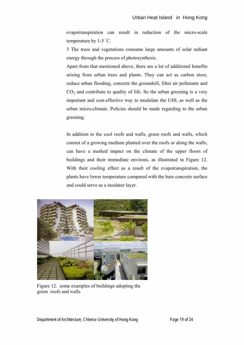
In addition to the cool roofs and walls, green roofs and walls, which
consist of a growing medium planted over the roofs or along the walls,
can have a marked impact on the climate of the upper floors of
buildings and their immediate environs, as illustrated in Figure 12.
With their cooling effect as a result of the evapotranspiration, the
plants have lower temperature compared with the bare concrete surface
and could serve as a insulator layer.
Figure 12. some examples of buildings adopting the green roofs and walls
Urban Heat Island in Hong Kong
Department of Architecture, Chinese University of Hong Kong Page 20 of 24
Urban Geometry: The urban geometry, such as the SVF, H/W ratio
etc, has great influence on the formation of the UHI. But it is yet
unknown that how different urban radiative geometries explicitly cause
change of the air temperature and this issue needs further research.
Fortunately it is found by previous study (named as AVA project) [24]
that optimizing the natural ventilation inside the city could be an
effective method to improve the heat extraction rate and to provide
more thermal comfort (Please refer to [24] for detailed information
about the AVA project). The UHI is always observed at calm, clear
nights or days and disappear when there is wind [13,14,19]. The speed
of wind is significantly reduced inside the city, which is known as the
canyon effect, referring to the Figure 13. The higher the H/W, the
urban wind is one that can be dominated and modified by urban design.
The main urban design elements which can modify the wind conditions
are the overall density of urban area, size and height of the individual
buildings, existence of high-rise buildings and the orientation and
width of the streets [8].
Figure 13. Different urban geometry and the corresponding airflow scenarios. (Oke, 1987)
Urban Heat Island in Hong Kong
Department of Architecture, Chinese University of Hong Kong Page 21 of 24
Reduction of anthropogenic heat release: Anthropogenic heat,
although not a very important factor causing the UHI, it could play
significant role in certain condition. It is found that impact of
anthropogenic heat may be important in urban centers but negligible in
residential and commercial areas [24]. Besides, anthropogenic heat
due to, for example the energy consumed for air conditioning, could be
reduced by human habit, i.e, by adjusting the air conditioner to
comfortable temperature instead of to very low temperature. These
kinds of actions not only reduce the anthropogenic heat release to some
extent, more importantly, they also have important meaning in saving
the energy.
Urban Heat Island in Hong Kong
Department of Architecture, Chinese University of Hong Kong Page 22 of 24
What More Needs to be Known about Hong Kong’s UHI?
Although there are studies focusing on the urban heat island of Hong
Kong, the information that is available about Hong Kong’s UHI is not
complete. Compared with the other major cities, such as London and
Tokyo, our understanding of the causative factors, the form and
intensity, the socio-economic and environmental impacts of Hong
Kong’s UHI, and the guideline to mitigate Hong Kong’s UHI remains
rudimentary.
The following subjects require further research on Hong Kong’s UHI:
1) Detection and characteristic of UHI – Develop a network of weather stations
across Hong Kong to record critical climate variables, such as short and
long-wave radiation, temperature, humidity, wind speed and direction.
Utilize the fine resolution image by satellite remote sensing to detect and
characterize the spatial and temporal distribution of the UHI intensity.
2) Use the gathered climate data to build an urban energy balance model for
Hong Kong that can be applied at a variety of spatial scales.
3) Develop a decision support tool for planners, urban designers and architects
to help identify and prioritize ‘anti-UHI’ interventions, such as targeted
urban greening, urban geometry and cool material programmes
4) Assess the contribution of the UHI to heat related excess deaths, and use
evidence to inform the local heat wave plan
5) Collect data on Hong Kong’s anthropogenic heat emissions and model
future heat emissions to determine how to manage this potential extra source
of heat
6) Implement a range of anti-UHI demonstration projects that apply a number
of UHI mitigation and collect requisite climate data to assess efficacy
Urban Heat Island in Hong Kong
Department of Architecture, Chinese University of Hong Kong Page 23 of 24
References:
Acknowledgement:
“Urban Heat Island in London” is referred.
[1] Helmut E. Landsberg , The Urban Climate. New York Academic Press (1981)
[2] L. Howard, The climate of London, Vols I-III, London
[3] T. J. Chandler, City Growth and Urban Climates, Weather, Vol. 19,170-171 (1965)
[4] I. T. Lyall, The London Heat-Island in June-July 1976, Weather, 32(8), 296-302 (1977)
[5] L. Barring, J. O. Mattsson and S. Lindovist, Canyon geometry, street temperatures and
urban heat island in Malmo, Sweden, Journal of Climatology, Vol. 5, 433-444 (1985)
[6] H. Swaid and M. E. Hoffman, Climatic Impacts of Urban Design Features for High and
Mid Latitude Cities, Energy and Buildings, Vol. 14, 325-336 (1990)
[7] The Environmental Protection Agency (U.S.) : http://www.epa.gov/heatisland/
[8] A. Urano and Y. Morikawa, Case Study: (a) the United States. IBEC, No. 138, 2003
[9] S. D. Chow, The Urban Climate of Shanghai, Atmospheric Environment, Vol. 26B, 9-15
(1992)
[10] N. H. Wong, Study of Urban Heat Island in Singapore
[11] J. Nichol and M. S. Wong, Modeling urban environmental quality in a tropical city,
Landscape and Urban Planning, Vol. 73, 49-58 (2005)
[12] The physiological equivalent temperature- a universal index for the biometeoro-logical
assessment of the thermal environment, International Journal of Biometeorology, Vol 43, 71-