Page 1
URBAN PLANNING AND DEVELOPMENT OF EASTLEIGH
DISTRICT COMMERCIAL CENTRE IN NAIROBI.
By;
MUSYIMI TAABU ANNAH
B52/60941/2010
UNIVERSITY OF NAIROBI
SCHOOL OF THE BUILT ENVIRONMENT
DEPARTMENT OF ARCHITECTURE AND BUILDING SCIENCE
A RESEARCH PROJECT SUBMITTED IN PARTIAL FULFILLMENT
FOR THE REQUIREMENT OF THE MASTER OF ARCHITECTURE
DEGREE IN THE UNIVERSITY OF NAIROBI.
JULY 2013
Page 2
Page i
DECLARATION
I do hereby declare that this Research Project is my original work and has
not been presented for a degree in any other university.
Signature……………………….. Date...............................................
Musyimi Taabu Annah. B52/60941/2010
This Research Project has been submitted for examination with my
approval as the university supervisor.
Signature: ..................................... Date: ..............................................
Dr. Laban Shihembetsa,
Senior Lecturer, Department of Architecture and building science.
Signature: ..................................... Date: ..............................................
Dr. Peter A. Makachia
Senior Lecturer, Department of Architecture and environmental
design, Kenya Polytechnic University College
Page 3
Page ii
DEDICATION
I dedicate this work to my Husband Willy Kioko Malile and my son Allan
Muthusi Kioko for they kept on inspiring me to do more than I had done
before.
Page 4
Page iii
ACKNOWLEDGEMENT
I would like to thank my supervisors Dr. Laban Shihembetsa, and Dr.
Peter A. Makachia for they tirelessly directed me towards attaining the
best in my research.
Special thanks to DR. Kakumu for his valuable guidance in this research
paper.
I would also like to thank my class-mates and the department of
Architecture fraternity for they kept reminding me of the importance of
keeping in the right direction in my research.
Page 5
Page iv
TABLE OF CONTENTS.
Declaration…………………………………………………………………i
Dedication…………………………………………………………………ii
Acknowledgement………………………………………………………..iii
Table of contents……………………………………………………….…iv
List of figures……………………………………………………………viii
List of tables…………………………………………………………….....x
List of maps ….…………………………………………………………..xi
List of diagrams ...……………………………………………………….xii
List of terminologies …………………………………………………....xiii
List of abbreviations and acronyms……………………………………..xiv
Abstract…………………………………………………………...……...xv
References………………………………………………………………..xv
CHAPTER ONE: INTRODUCTION:
1.0. BACKGROUND TO THE STUDY …………….…..........1
1.1. BACKGROUND TO THE STUDY PROBLEM.………...5
1.2. RESEARCH PROBLEM STATEMENT…………………7
1.3. RESEARCH AIM AND OBJECTIVES.…….……………8
1.4. RESEARCH QUESTIONS…………………………….....8
1.5. SIGNIFICANCE OF THE STUDY………………............9
1.6. STUDY ASSUMPTIONS ……………………………......9
1.7. SCOPE AND LIMITATIONS OF THE STUDY…….....10
1.8. OPERATIONAL DEFINITION OF TERMS …….….....11
1.9. STRUCTURE OF THE STUDY…...…………...….........12
1.10. DISSERTATION REPORT CONCEPTUAL MODEL…14
Page 6
Page v
CHAPTER TWO: LITERATURE REVIEW.
2.0. INTRODUCTION……………………………………….15
2.1.COMPREHENSIVE URBAN PLANNING………………...15
2.1.1 URBAN PLANNING SUMMARY MODEL…...17
2.2 STRATEGIC URBAN PLANNING…………………….18
2.2.1. CHARACTERISTICS OF STRATEGIC URBAN
PLANNING……………………………………...18
2.2.2. STRATEGIC URBAN PLANNING PROCESS...19
2.2.3. STRATEGIC URBAN PLANNING PROCESS
MODEL………………………………………….23
2.3. GRID URBAN PLANNING ……………………………24
2.3.1. ANCIENT GRID PLANS……………………….24
2.3.2. THE BARCELONA EIXAMPLE……………….26
2.3.3. CITY BEAUTIFUL……………………………...27
2.3.4. CHANDIGARH………………………………....28
2.2.5. MILTONE KEYNES ……………………………29
2.4. STREETSCAPE DESIGN………………………………30
2.4.1. THE WOONERF………………………………...30
2.5. URBAN PUBLIC SPACES……………………………..31
2.6. ZONING…………………………………………………32
2.6.1. ZONING SUCCESSES ………………………....33
2.6.2. FAILURES OF ZONING………………………..34
2.6.3. ALTERNATIVE TO TRADITIONAL ZONING.34
2.6.4. FORM BASED CODES…………………………34
2.7. THEORETICAL FRAMEWORK ……………………....38
Page 7
Page vi
2.7 SUMMARY……………………………………………...39
CHAPTER THREE: METHODOLOGY:
3.0. INTRODUCTION ………………………………………40
3.1. RESEARCH DESIGN…………………………………...40
3.2. TARGET POPULATION………………………………..40
3.3. DATA COLLECTION INSTRUMENTS……………….41
3.4 DATA COLLECTION PROCEDURE………………….42
3.5. CONCEPTUAL FRAMEWORK……………..…………43
3.6. DATA ANALYSIS………………………………………44
3.6.1. QUALITATIVE ANALYSIS…………………....45
3.6.2. CONTEXTUAL SPATIAL ANALYSIS……….45
3.6.3. DESCRIPTIVE ANALYSIS……………………45
3.7. DATA PRESENTATION………………………………..46
CHAPTER FOUR: RESEARCH FINDINGS
4.0. INTRODUCTION………………………………….…....47
4.1. URBAN PLANNING AND DESIGN OF EDCC……....47
4.1.1. POLICY PLANS…………………………….…..47
4.1.2. ZONING…………………………………..……..57
4.2. DEVELOPMENTS IN EASTLEIGH DISTRICT
COMMERCIAL CENTRE ……………………………...57
4.2.1. PHYSICAL INFRASTRUCTURE………………57
4.2.2. SOCIAL INFRASTRUCTURE…………………64
4.2.3. BUILDINGS……………………...……………...65
4.3. SUMMARY…………………………..……………………75
Page 8
Page vii
CHAPTER FIVE: CONCLUSIONS AND RECOMMENDATIONS:
5.0 INTRODUCTION……………………………………….79
5.1. CONCLUSIONS…...……………………………………79
5.2. RECOMMENDATIONS...………………………………80
5.2.1 POLICY MAKERS…...........................................80
5.2.2. DEVELOPERS…..................................................93
5.2.3. USERS…………………………………………...93
5.2.4. RESEARCHERS…………………………….…..94
5.2.5. PRACTITIONERS……………………………....94
APPENDIX:
CASE STUDY PROTOCOL.
Page 9
Page viii
List of figures.
Figure 1.1. Eastleigh District Commercial Centre (Pg. 10)
Figure 1.2. Dissertation report conceptual model (Pg. 14)
Figure 2.1. Plan of Melitus. (Pg. 25)
Figure 2.2. Barcelona map (Pg. 26)
Figure 2.3. Barcelona’s blocks (Pg. 26)
Figure 2.4. The resultant urban form of Barcelona eixample. (Pg. 27)
Figure 2.5. 1909 Plan of Chicago. (Pg. 27)
Figure 2.6 plan of Chandigarh. (Pg. 29)
Figure 2.7 A one square km sector in Milton Keynes framed by major
roads on a grid. (Pg. 30)
Figure 2.8. Theoretical framework conceptual model (Pg. 38)
Figure 4.1. Road network for EDCC (Pg. 58)
Figure 4.2. Rehabilitated General Waruingi Street. (Pg. 59)
Figure 4.3. Drainage system at junction of First and Fifth Avenues. (Pg.
59)
Figure 4.4. Rehabilitation of Second Avenue. (Pg. 60)
Figure: 4.5. Rehabilitation of General Waruinge road. (Pg. 60)
Figure 4.6. Motorized transport system in Eastleigh to the CBD. (Pg. 61)
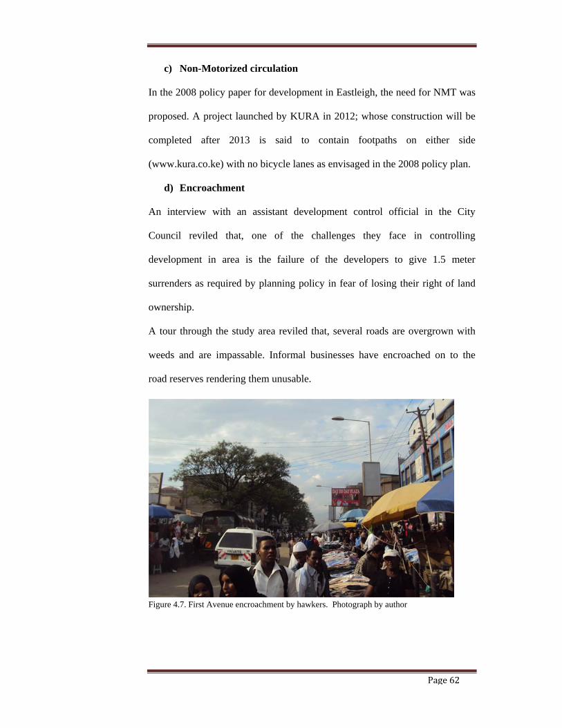
Figure 4.7. First Avenue encroachment by hawkers. (Pg. 62)
Figure 4.8: Dumping along Major Jackson Muriithi road. (Pg. 63)
Figure 4.9: Sold out CCN market land and first avenue encroachment by
Hawkers. (Pg. 65)
Figure 4.10. Building developments in EDCC. (Pg. 66)
Figure 4.11. Illustrations of development slender on plan (Pg. 67)
Page 10
Page ix
Figure 4.12. Illustrations of development slender on plan (Pg. 67)
Figure 4.13. Illustrations of development slender on plan (Pg. 68)
Figure 4.14. Illustrations of development square on plan (Pg. 69)
Figure 4.15. Urban form of EDCC (Pg. 70)
Figure 4.16. Vacant land ready for development. (Pg. 71)
Figure 4.17. Cross sectional analysis of urban form. (Pg. 71)
Figure 4.18. Cross sectional analysis along General Waruingi Road
between First Avenue and Second Avenue. (Pg. 72)
Figure 4.19. Analysis across General Waruingi. (Pg. 72)
Figure 4.20. Analysis from First Avenue facing Sargent Major Kamugobe
Street. (Pg. 72)
Figure 4.21. Analysis along General Waruingi Road between First Avenue
and Second Avenue. (Pg. 73)
Figure 4.22. Analysis along First Avenue showing high level
developments (Pg. 73)
Figure 4.23. Malls on First Avenue. (Pg. 74)
Figure 5.1. Proposed reorganization of traffic transport system (Pg. 84)
Figure 5.2. Proposed Section through 21 Meter wide internal road (Pg. 85
Figure 5.3. Proposed section through 18 Meter wide internal road (Pg. 85)
Figure 5.4. Proposed section through 12 Meter wide internal road (Pg. 86)
Figure 5.5. Proposed section through a 6 Meter wide internal road (Pg. 86)
Figure 5.6. Proposed public transport systems (Pg. 87)
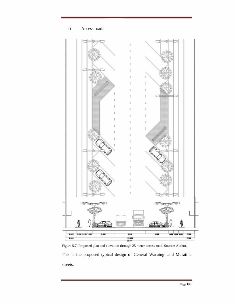
Figure 5.7. Proposed plan and elevation through 25 meter access road (88)
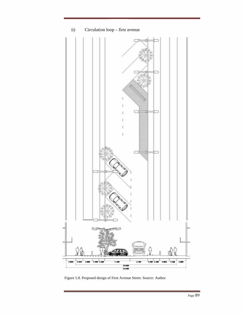
Figure 5.8. Proposed design of First Avenue Street (Pg. 89)
Figure 5.9 Proposed design of Second Avenue and Second Street (Pg. 90)
Page 11
Page x
List of tables.
Table 1.1: Zoning ordinance for zone 2 of Nairobi (Pg. 05)
Table 3.1. Data collection instruments (Pg. 42)
Table 4.1. EDCC zoning ordinance (Pg. 57)
Table 4.2. Strategic issues in 2008 Policy paper for EDCC (Pg. 75)
Page 12
Page xi
List of maps.
Map 1.1. Nairobi boundary changes (Pg. 01)
Map 1.2. The Plan of Nairobi as depicted in the 1948 Master Plan (Pg. 02)
Map 1.3. The Plan of Nairobi as depicted in the 1973 MDG (Pg. 03)
Map 1.4. Kenya and Nairobi location maps. (Pg. 04)
Map 1.5. Map of Eastleigh. (Pg. 04)
Page 13
Page xii
List of diagrams
Diagram 2.1. Urban planning conceptual model (Pg. 17)
Diagram 2.2. Strategic urban planning model. (Pg. 23)
Diagram 3.1. Research variables. (Pg. 44)
Page 14
Page xiii
List of terminologies
Urban planning
Urban design
The grid plan
Strategic urban planning
Form based code
Page 15
Page xiv
List of Abbreviation and Acronym
EDCC Eastleigh District Commercial Centre.
CBD Central Business District.
FBC Form Based Code.
CCN City Council of Nairobi.
MDG Millennium Development Goals.
NMT Non-Motorized Transport.
KURA Kenya Urban Roads Authority.
NAWASCO Nairobi Water and Sewerage Company.
MoE Ministry of Energy.
MoW Ministry of Water.
MoH Ministry of Health.
CSP Case Study Protocol.
Page 16
Page xv
ABSTRACT:
There is an implementation gap between the urban planning and design framework of Eastleigh District Commercial Centre EDCC) with the development of the centre leading to higher building densities and deteriorating infrastructural provision rendering both physical and social infrastructure inadequate to support the high building densities and the development of EDCC as an integrated secondary commercial center. This problem was the basis of the aim of my research drawing lessons for planning and design of EDCC based on compliance of developments to the planning ordinances. Different samples were studied in physical infrastructure, social infrastructure and buildings. Samples studied in the physical infrastructure included road and drainage system, water and sewerage system, solid waste management. Those of social infrastructure included business activities in space, education facilities, health facilities, housing facilities, and markets facilities. Building densities as controlled by plot ratio, plot coverage and building line where the elements I studied in building developments. I chose the above samples randomly. From my filed work analysis, I found out that the 2008 policy plan was not implemented hence both physical and social infrastructure is not efficient as envisioned in the policy paper. The building densities surpass the ordinance densities. This influenced my conclusions that developments in EDCC do not comply with the planning ordinances. Therefore, I recommend inclusion of other stakeholders like developers, architects, planners, urban designers, and private sector to be part of the planning team and follow the strategic planning process to the latter. The planning team should also consider developing form based codes to be used in parallel with zoning ordinances as literature shows there is better compliance with three dimensional form based codes than two dimensional zoning ordinances.
Page 17
Page 1
1 2 3 45
1. CHAPTER ONE: INTRODUCTION.
1.0. BACKGROUND TO THE STUDY.
Planning and design of urban areas is important to ensure conformity and
balance of the built environment (Bailey 1975). Nairobi has been planned
using the comprehensive urban planning approach. Comprehensive urban
planning is used as a ‘design” where by the planners are seen as architects
who develop comprehensive master plans (Taylor, 1998). The master
plans that have guided the development of the city of Nairobi include: 1.
the plan for a railway town in 1906 (Emig and Ismail, 1980), 2. 1927 plan
for a settler capital, 3. 1948 master plan for a colonial capital, 4. The
Nairobi Metropolitan Growth Strategy of 1973 and 5. The current Nairobi
Metropolitan Region.
Map 1.1.Nairobi boundary changes. Source: digitized by author from Obudho and
Aduwo (1992:53) and www/http://na.unep.net
Thika Municipality
Kangundo
Ngong
Matungulu
Mavoko
Kajiado central
Limuru
Kikuyu
Kiambaa Ruiru
Gatanga
Page 18
Page 2
The master plans for the city of Nairobi which have had an impact in
urban planning and designing of Eastleigh District Commercial Centre are
the 1948 master plan and 1973 Nairobi Metropolitan Growth Strategy.
In the 1948 master plan, Nairobi was classified into zones with
functionalism as the main principle for the zoning. Racial zoning was
rationalized as “the need to achieve a disease free environment with
minimum of public expenditure (Amis 1980:86). This factor led to
Eastleigh district to be dominated by Kenyan Somalis where they had
been moved in 1920 following the 1914 Simpson report after the plague in
the Indian bazaar recommending segregation of the races that had
congregated in Nairobi.
Map 1.2.The Plan of Nairobi as depicted in the 1948 Master Plan. Source: ETH studio
Basel, History of Urban Planning in Nairobi by Martina Vogel.
Page 19
Page 3
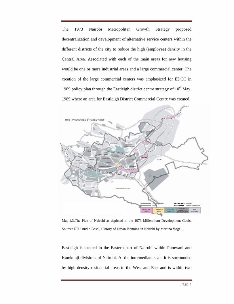
The 1973 Nairobi Metropolitan Growth Strategy proposed
decentralization and development of alternative service centers within the
different districts of the city to reduce the high (employee) density in the
Central Area. Associated with each of the main areas for new housing
would be one or more industrial areas and a large commercial center. The
creation of the large commercial centers was emphasized for EDCC in
1989 policy plan through the Eastleigh district centre strategy of 10th May,
1989 where an area for Eastleigh District Commercial Centre was created.
Map 1.3. The Plan of Nairobi as depicted in the 1973 Millennium Development Goals.
Source: ETH studio Basel, History of Urban Planning in Nairobi by Martina Vogel.
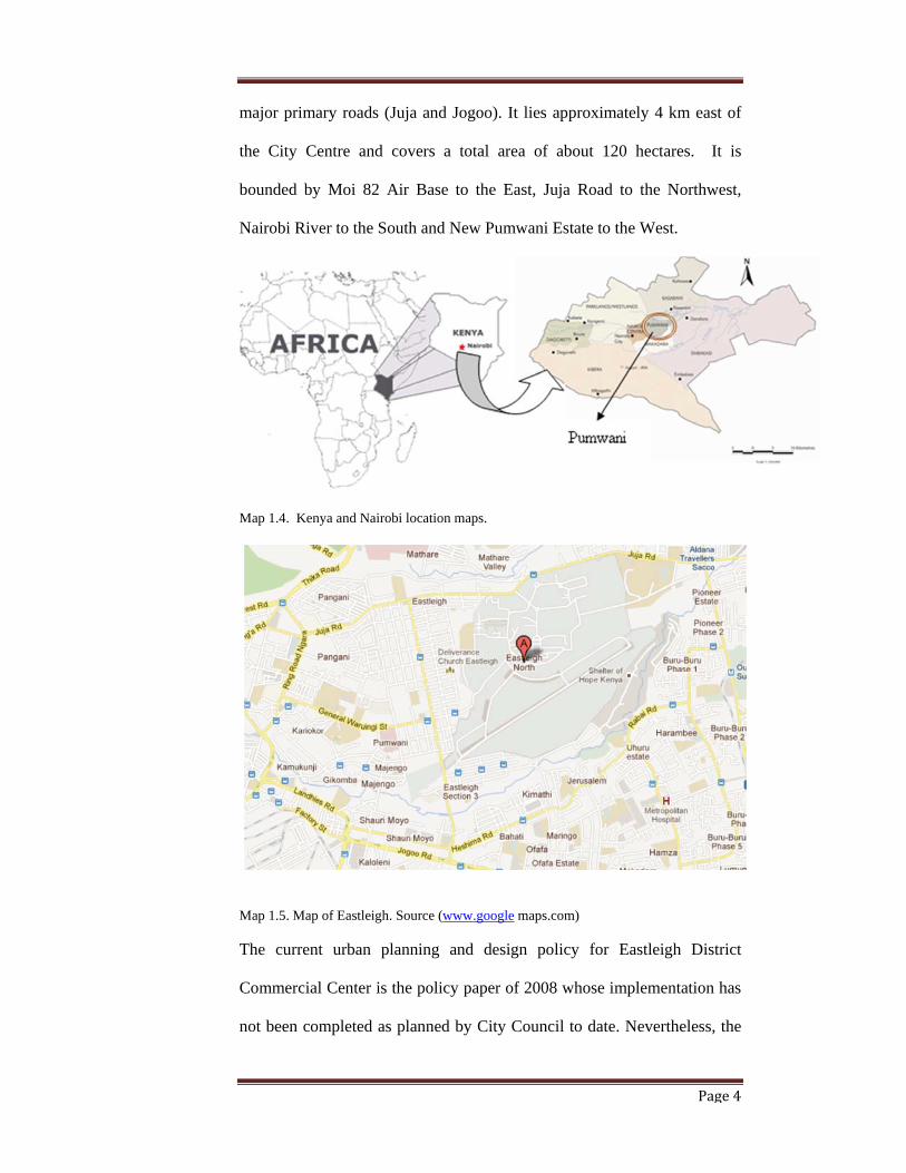
Eastleigh is located in the Eastern part of Nairobi within Pumwani and
Kamkunji divisions of Nairobi. At the intermediate scale it is surrounded
by high density residential areas to the West and East and is within two
Page 20
Page 4
major primary roads (Juja and Jogoo). It lies approximately 4 km east of
the City Centre and covers a total area of about 120 hectares. It is
bounded by Moi 82 Air Base to the East, Juja Road to the Northwest,
Nairobi River to the South and New Pumwani Estate to the West.
Map 1.4. Kenya and Nairobi location maps.
Map 1.5. Map of Eastleigh. Source (www.google maps.com)
The current urban planning and design policy for Eastleigh District
Commercial Center is the policy paper of 2008 whose implementation has
not been completed as planned by City Council to date. Nevertheless, the
Page 21
Page 5
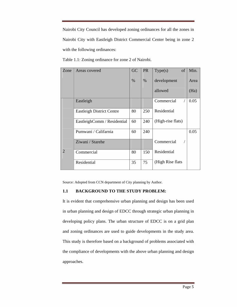
Nairobi City Council has developed zoning ordinances for all the zones in
Nairobi City with Eastleigh District Commercial Center being in zone 2
with the following ordinances:
Table 1.1: Zoning ordinance for zone 2 of Nairobi.
Source: Adopted from CCN department of City planning by Author.
1.1 BACKGROUND TO THE STUDY PROBLEM:
It is evident that comprehensive urban planning and design has been used
in urban planning and design of EDCC through strategic urban planning in
developing policy plans. The urban structure of EDCC is on a grid plan
and zoning ordinances are used to guide developments in the study area.
This study is therefore based on a background of problems associated with
the compliance of developments with the above urban planning and design
approaches.
Zone Areas covered GC
%
PR
%
Type(s) of
development
allowed
Min.
Area
(Ha)
2
Eastleigh Commercial /
Residential
(High-rise flats)
0.05
Eastleigh District Centre 80 250
EastleighComm / Residential 60 240
Pumwani / Califarnia 60 240
Commercial /
Residential
(High Rise flats
0.05
Ziwani / Starehe
Commercial 80 150
Residential 35 75
Page 22
Page 6
Globally, there are challenges associated with comprehensive urban
planning and master plans. Comprehensiveness and rationality in urban
planning try to define future end-states and goals that strongly depart from
the current situation (Lindblom and Bay Brooke, 1963). It is difficult for
planners to predict effects of alternatives that depart strongly from the
current situation and a master plan is not flexible enough to take into
account other developments in future. The master plan’s two dimensional
nature causes the problem of unifying it with architecture pattern and form
which is three dimensional. Comprehensive urban planning focuses too
much on design leaving the social, political and economic aspects of the
urban society.
Additionally, strategic urban planning used in developing the policy plans
for EDCC has theoretical problems. Theoretically, strategic urban
planning was adapted from the military to business sector before its use in
public planning. Private and public arenas have different settings in the
political arena, public arena and control and monitoring mechanisms. As a
result of these differences strategic planning concepts from the business
sector can be used in the public sector, on condition that planners take into
account the political arena, the public arena and the formal processes and
regulations that ensure democratic decision-making (Nutt and
Backoff1995; Stone, Bryson and Einsweiler, 1988)
As stated by Bernstein 1994, implementations of the master plans and
policy plans are affected by the general inefficiency associated with
majority of the developing countries’ land policies, and the absence of
Page 23
Page 7
secure tenure, adequate land management capacity, inappropriate
instruments and weak institutional measures, (Bernstein; 1994).
The grid urban planning applied in EDCC has its theoretical problems.
According to Camillo Siite (Camillo, 1889) grids lack variety and,
consequently, are uninteresting and can become oppressive by their
monotony. Grid system causes congestion at intersections and
vulnerability of pedestrians. The long travel distances in grid urban
planning consumes large pieces of land with the inherent high street and
intersection frequencies producing large areas of impermeable surfaces in
street pavement and sidewalks.
1.2. RESEARCH PROBLEM STATEMENT:
There is an implementation gap between the urban planning and design
framework of Eastleigh District Commercial Centre with the development
of the centre. Lack of implementation of the policy plans and zoning
ordinances in the development of the Centre is leading to higher building
densities and deteriorating infrastructural provision rendering both
physical and social infrastructure inadequate to support the high building
densities and the development of EDCC as an integrated secondary
commercial center.
In particular physical infrastructure including roads and drainage system,
water and sewerage system, solid waste management system have not
been developed as planned in the 2008 policy plan. Additionally, social
infrastructural services like business activity spaces, education facilities,
health facilities, housing facilities, market facilities have not been
provided as planed in the 2008 policy plan. Building densities including
Page 24
Page 8
plot coverage and plot ratio, building lines and setbacks are happening in
disregard to the urban zoning ordinances.
1.3. RESEARCH AIM AND OBJECTIVES
The aim of this study is to compare the urban planning and design
frameworks with the developments of EDCC by analyzing the urban
planning and design approaches used in EDCC through reviewing the
urban planning and approaches, assessing developments in EDCC against
the urban planning and design approaches and thereof drawing lessons for
urban planning and design practice of EDCC. To attain this aim, the
following were the objectives of the study;
i. To review the urban planning and design approach used in
Eastleigh District Commercial Centre.
ii. To assess the developments against the urban planning and design
approaches of Eastleigh District Commercial Centre so as to
establish the degree of compliance.
iii. To bring up the implications of the degree of compliance and the
lessons for urban planning and design approaches thereof
established.
1.4. RESEARCH QUESTIONS:
To attain the above aims and objectives the study sought to answer the
following research questions:
i) Which urban planning and design method is used in planning and
designing EDCC and how is it being applied?
ii) Are the developments in EDCC compliant to the urban planning
and design ordinances of EDCC?
Page 25
Page 9
iii) What lessons can we learn from the planning and development
outcomes in the study area?
1.5. SIGNIFICANCE OF THE STUDY:
The comparison of urban planning and design framework with the
developments of EDCC is significant to the planning team in assessing the
degree of success in guiding the development of the commercial centre.
The urban planning and design lessons hereof brought out can be used by
the planning team as guidelines on developing urban planning and design
framework for Eastleigh District Commercial Centre and other
commercial Centers in Urban areas in Kenya. In addition, the lessons
thereof learned become essential contribution to urban planning and
design in general.
1.6. STUDY ASSUMPTIONS
The study assumed that urban planning and design of EDCC is manifested
in physical infrastructure, social infrastructure and buildings in the area.
Simple random selection method of physical infrastructure elements
including roads and drainage system, water and sewerage system and
waste disposal was done to be utilized in this research. The same was done
for social infrastructure elements including education facilities, health
facilities, housing and markets. Buildings for study and analysis were also
chosen randomly.
1.7. SCOPE AND LIMITATIONS OF THE STUDY:
The study covered a geographical area referred to as Eastleigh District
Commercial Center as delineated by the 1989 policy plan for zone two
which was defined by the Eastleigh District strategy of 10th May, 1989. It
Page 26
Page 10
was recommended that the area bounded by Muratina Street to the West,
General Waruingi Street to the South, 82 Airforce to the East and Juja
Road to the North be declared the Eastleigh District Commercial Centre.
Figure 1.1. Eastleigh District Commercial Centre. Digitized by author from GIS maps.
This research was carried out within a limited time and resources. The
religion; Islam, of a majority of the people in Eastleigh District
Commercial Centre hinders interaction with my gender hence getting the
information from them was not easy. My academic background was also
limiting because I am not privy to urban planning ideologies having been
trained as an architect. I overcame this limitation by indulging into deep
literature review of urban planning theories through the guidance of my
tutors.
JUJA ROAD
GENERAL WARUIGE
MOI 82 AIRFORCE
MURATINA ROAD
Page 27
Page 11
1.8 OPERATIONAL DEFINITION OF TERMS
Urban planning is a technical and political process concerned with the
control of the use of land and design of the urban environment, including
transportation networks, to guide and ensure the orderly development
urban environment.
Urban design is the collective term used to describe the process of
designing and shaping cities and towns. It addresses the larger scale of
groups of buildings, streets and public spaces to make urban environment
functional and attractive.
The grid plan is a type of urban plan with a focus on plans in which the
street networks run almost or at right angles to each other, forming a grid
of network.
Strategic urban planning is a type urban planning process that involves
interdependency of all stakeholders including public participation with
planning experts in coming up with regulations guiding the built urban
environment considering strengths, weaknesses, opportunities and threats
of the process and outcome.
Form based code is a land development regulatory tool with a focus on
shapes, forms and image, that places primary emphasis on the physical
form of the built environment with the end goal of producing a specific
type of place.
Page 28
Page 12
1.9 ORGANISATIONAL STRUCTURE OF THE STUDY:
This research document is structured into six chapters each containing
specific items which are interrelated to make one document. The chapters
are designed to contain the following:
Chapter one Introduction: An introduction to the study subject
is made in this chapter with some background of the
study being elucidated. A succinct statement of the
study problem is made, research questions stated,
objective and justification of the study are made in
this chapter. This chapter is terminated with
definitions of terminologies used in the dissertation.
Chapter two Literature review: The review has focused on
comprehensive urban planning with emphasis on
strategic urban planning as a comprehensive
planning process. Urban design theories have also
been reviewed with emphasis on grid urban plans
because EDCC has a grid urban structure. A
theoretical background of Zoning has also been
presented because EDCC has a zoning ordinance
development by city Planning department of NCC
that guides developments of the area.
Chapter three Methodology: This chapter of the report presents a
description of the methods that were applied in
carrying out the research study. It describes the
research strategy, research design, research
Page 29
Page 13
instruments, data collection, data analysis and
presentation techniques.
Chapter four Research findings: Urban planning and design
practices in the case study area are presented in this
chapter as the basis for presentation and analysis of
the data collected in the field concerning
developments in EDCC’s against the urban
planning and design approaches. It is an assessment
of the degree of the developments compliance with
the planning policies and the zoning ordinance.
Chapter five Conclusions and recommendations: Conclusions
on urban planning and design of Eastleigh District
Commercial Center with all theoretical background
reviewed and findings thereof obtained are
presented in this chapter in a summary format.
Guidelines of developing an implementable urban
planning and design framework are given and areas
of further research suggested.
Page 30
Page 14
1.10. DISSERTATION REPORT CONCEPTUAL MODEL
Figure 1.2. Dissertation report conceptual model by author.
URBAN PLANNING
COMPREHENSIVE URBAN PLANNING
STRATEGIC URBAN PLANNING
GRID PLANS
PHYSICAL INFRASTRUCTURE
SOCIAL INFRASTRCTURE
BUILDINGS
ZONING ORDINANCE
POLICY PLAN
MASTER PLANS
DEVELOPMENTS
LIT
ER
AT
UR
E -
TH
EO
RE
TIC
AL
FIE
LD
WO
RK
–R
ES
ER
CH
FIE
LD
SU
RV
EY
E
MP
ER
ICA
L D
AT
A
Page 31
Page 15
2. CHAPTER TWO: LITERATURE REVIEW:
2.0 INTRODUCTION:
This chapter contains a theoretical background of urban planning and design
approaches used in EDCC including comprehensive urban planning through
strategic urban planning used in development of the policy plans for EDCC;
grid plan following the design of the street system of EDCC and zoning
following the zoning ordinance for zone two of Nairobi City where EDCC is
found.
A background of the evolution of urban planning from comprehensive urban
planning to strategic urban planning is reviewed. Following the strategic
urban planning approach used in developing the different planning policies for
EDCC a literature review of strategic urban planning is presented.
With reference to infrastructural design of Eastleigh District commercial
Centre which is a grid plan, literature review on grid plan was done to give
insights into the different approaches used to overcome the problems
associated with grid plans.
It has already been noted in the introduction part of this dissertation that the
city planning department in NCC has developed zoning ordinances for the
different zones of Nairobi City including EDCC which falls in zone 2. This
necessitated literature review on zoning as a tool used in comprehensive urban
planning and emerging trends that give insights on achieving implementable
zoning ordinances like the Form based Codes.
2.1. COMPREHENSIVE URBAN PLANNING
Comprehensive urban planning is the oldest known urban planning approach
in which planners are seen as architects who developed comprehensive master
Page 32
Page 16
plans (Taylor, 1998; Van Vught, 1979; Kreukels, 1980). The underlying
theory is that of planning as design. Just like buildings can be build based on
detailed blueprints, so too can a town be developed by reference to its master
plan”. Kent (1964).
Due to different problems associated with master planning like social
blindness, Bouer (1969), inflexibility, definition of future end-states and goals
that strongly departed from the current situation (Lindblom and Baybrooke,
1963) other urban planning approaches evolved. They were based on either
continuation of the comprehensive planning or reaction to it.
Lack of political considerations of rational comprehensive planning led to
rational process planning led by Chicago school. Its inflexibility led to
incremental planning by Lindblom while the short term nature of incremental
planning led to mixed scanning approach by Etzioni (Etzion, 1967)
Nevertheless, ideas of comprehensiveness and rationality in planning were
continued with planning theory being divided into focus on the object of
planning; the city, and the planning process. The city was considered as a
system of different parts resulting into systems planning and on the other
hand, planning process was being considered resulting to advocacy planning
for planning process as political process, transactive planning as process of
change, communicative planning as a process of communication between all
stakeholders, interactive planning as a process of working with and learning
from the stakeholders and later strategic planning as a process of
interdependency within the stakeholders.
Page 33
Page 17
2.1.1. URBAN PLANNING SUMMARY MODEL
Diagram 2.1. Urban planning summary model developed by author
Rational comprehensive planning:
Incremental
planning.
(Lindlom, 1963)
Mixed scanning
(Etzioni 1967)
Systems
planning
(Friedmann,
1969)
Advocacy
planning.
(Taylor,
1998)
Procedural
planning.
(Faludi ,
1973)
Transactive
planning.
(Friedmann,
1973)
Communicative
planning.
Forester 1985,
1989, 1993)
Interactive
planning.
(Salet and
Faludi, 2000)
Strategic
urban
planning.
Bryson 1993)
Lack political
consideration
Lack social and economic consideration
Process view
of planning
(Planning
focused on
the process
not the object
Planning as
a process of
change
Communication
within
stakeholders
Working and
learning with
stakeholders
Interdependency
within
stakeholders
Planning as
a political
process
Rational process
planning.
(Chicago school)
Object view of
planning
(City is seen
as an object
with different
systems)
Inflexibility
Page 34
Page 18
2.2. STRATEGIC URBAN PLANNING:
At the end of the seventies, early eighties, theorists from the business sector
saw the possibilities of strategic planning for the public sector (Eadie, 1983;
Sorkin, Ferris and Hudak, 1984; Toft, 1984; Denhardt, 1985; Ackoff, 1970;
Ansoff, 1980). They recognized that strategic planning provided concepts,
procedures and tools that could be 'imported' into public planning. Public
planners also saw the benefits (Bryson, 1993; Bryson and Einsweiler, 1988;
Bryson and Roering, 1988; Nutt and Backoff, 1995; Bryson, Van de Ven and
Roering, 1987). Strategic planning is seen as a learning process in which
organizations are viewed as open systems that are interconnected with, and
dependent on, other systems.
2.2.1. CHARACTERISTICS OF STRATEGIC URBAN PLANNING:
Regulation of urban development is entrepreneurial not managerial’ (Harvey
1989). Hence Planners in strategic urban planning should create an urban
environment encouraging for economic growth. Hall (2002, 379)
Public-private partnerships are the primary vehicles to promote, organize and
finance urban development (e.g. Fainstein 2001).
Urban strategy is expressed through major strategic projects (Healey 2010,
170). This ‘planning through projects’ (Carmona 2009) implies a move from a
territorial to a network approach to the city (Burgess/Carmona 2009, 26), with
interventions being limited to those areas and / or aspects which have the
potential to make ‘a difference to the fortunes of an area over time’ (UN-
HABITAT 2009a).
Strategic urban planning entails a holistic attitude, and it shifts the focus from
the governing of urban processes to their governance (Albrechts et al. 2003).
Page 35
Page 19
Ideas about the future development of a city are ‘lodged in the ‘hearts and
minds’ of the actors who command key resources’ (Healey 2010, 170),
The strategic planning process creates a more cooperative approach to urban
policies and new agencies in the planning.
2.2.2. STRATEGIC URBAN PLANNING PROCESS:
This process is based on a model developed by Bryson and Einsweiler (1988).
It is a normative model of how organizations in the public sector can engage
in strategic planning. However, for use in this research, the model is adapted
and refined by adding two arenas: the public and the political arena, and by
adding controlling mechanisms: the deliberately designed prescribed
procedures and regulations.
I) Initial agreement
According to Bryson and Einsweiler (1988) "the process begins with an initial
agreement (or plan for planning) among decision-makers whose support is
necessary for successful plan formulation and implementation. The goals of
these decision-makers should be aligned in order to reach some basic
agreement about the purpose of the effort, the topics to address, the form and
timing of reports and the stakeholders to be involved. Careful analysis is
needed to identify how much agreement there is between the multiple key
decision-makers.
II) Mandates
The second step is to get insight into the mandates or constraints confronting
the planning team (Bryson and Einsweiler, 1988). There are mandates that
come from the political arena, the public arena, legally established formal
procedures imposing restrictions on the strategy formulation process and
Page 36
Page 20
existing policy which are often stated in documents that have legal binding
status and that the planning team has to meet. Related to the mandates is
'control' from controlling bodies and constituencies (Smith Ring and Perry,
1985; Nutt and Backoff, 1995; Montanari and Bracker, 1986; Stone et al.,
1999; Hendrick, 2003
III) Mission and values
According to Bryson and Einsweiler (1988): The process draws attention in
particular to similarities and differences among those who have stakes in the
outcome of the process and in what the government's or agency's mission
ought to be in relation to those stakeholders. Stakeholder is defined as any
individual, group, or other organization that can place a claim on the
organizations attention, resources, or output or is affected by that output.
Often, mission, values and core-values are transmitted across more
generations of organizational members (Stone et al., 1999) and across multiple
internal disciplines that exist in large public government organizations
(Rainey, Backoff and Levine, 1976). Hence, there can be conflicting interests
within the organization itself. As a consequence, planners must consider both
external interests from the public and political arena and interests from the
internal organization.
IV) External opportunities and threats
The distinction between what is inside and what is outside hinges on whether
the organization controls the factor which places it inside, or does not, which
places it outside (Pfeffer and Salancik, 1978). To identify opportunities and
threats one might monitor a variety of political, economic, social and
technological forces and trends as well as various stakeholder groups,
Page 37
Page 21
including clients, customers, payers, competitors, or collaborators." the public
arena and the political arena need to be given more attention, because they are
characterized by a diverse set of stakeholders with changing and often
conflicting interests.
Other external forces that can influence the strategy formulation process are
related to the organization's financial dependency on higher government
bodies. The final external force is competition (Montanari and Bracker, 1986).
At first, competition from other governments, this means competition for
funds or resources and 'Private Sector Substitutes'; this concerns those private
parties who may do the tasks that were always considered public sector ones.
Private parties might be threats because they may be able to perform certain
tasks more efficiently and effectively.
V) Internal strengths and weaknesses
Strategic planning focuses on achieving the best fit between an organization
and its environment. This is concerned with getting sufficient resources
(input) to be able to carry out the plans. It concerns sufficient capacity, skilled
personnel; a clear structure of authority with leader behavior (process) related
to the goals to be achieved (performance). There is need for internal coalitions
(Montanari and Bracker, 1986) and a difference in internal culture (Stone et
al., 1999; Hendrick, 2003).
VI) Identifying strategic issues
Strategic issues are fundamental policy questions affecting the organization's
mandates, mission values, product or service level and mix, clients or users,
cost, financing, or management. Usually, it is vital that strategic issues be
dealt with expeditiously and effectively if the organization is to survive and
Page 38
Page 22
prosper. Failure to address a strategic issue typically will lead to undesirable
results from a threat, failure to capitalize on an important opportunity or both.
In the analysis of strategic issues, it is about the confrontation between the
external opportunities and threats and the internal or organizational strengths
and weaknesses. Through this confrontation it becomes clear what the main
problems are, or will be in the future, and if the organization is able to cope
with these opportunities and strengths." (Bryson and Einsweiler, 1988).
VII) Developing strategies
Strategy development begins with the identification of practical alternatives
for resolving the strategic issues. Then it moves to the enumeration of barriers
to the achievement of those alternatives, rather than directly to development of
proposals to realize the alternatives. (Bryson and Einsweiler, 1988). When
strategies are developed in the public sector the emphasis is focused on how
organizations can move toward high responsiveness coupled with appropriate
action (Nutt and Backoff, 1995). The basic idea of formulating a strategy is to
find the optimal fit between the opportunities and threats and the strengths and
weaknesses. An effective strategy in public organizations is concerned with
responding to the perceived needs of the stakeholders.
VIII) Description of organization in future
This description is the organization's vision of success, an outline of how the
organization would look if it successfully implemented its strategies and
achieved its full potential. Typically included in such descriptions are the
organization's mission, its basic strategies, its performance criteria, some
important decision rules, and the ethical standards of the organization's
employees."(Bryson and Einsweiler, 1988).
Page 39
Page 23
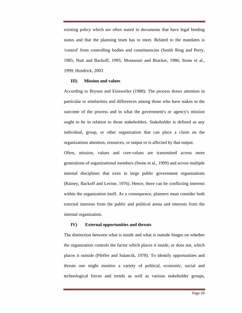
2.2.3. STRATEGIC URBAN PLANNING PROCESS MODEL
Diagram 2.2. Strategic urban planning model. Source; adapted from Bryson and Einsweiler
(1988) by author.
6. Strategic issues
4. External
environment
1. Initial agreement
2. Mandate
7. Strategies
Alternatives
Major
Proposals
Actions
Work program
8. Description of
organization in future
Action
Forces / trends
political
Economic
Social
Technological
Clients
Customers
Payers
Competitors
Collaborators
Opportunities
Threats
Strategy
Formulations
Implementation
Strategy
Formulations
Implementation
3. Mission / values
by stakeholders
5. Internal
environment
Resources
People
Economics
Information
Competencies
Present Strategy
Overall
Functional
Debt
Performance
Results
History
Strengths
Weaknesses
Results
Page 40
Page 24
Today, there is more and more attention given to strategic planning
approaches in planning theory (Albrechts, 2001; 2004; Kreukels, 2000;
Bryson, 2000). Several authors recognize that strategic planning provides
methods and concepts that are more market oriented, more pragmatic, and
more realistic than other planning approaches. It is increasingly assumed that
the solutions to the complex problems that confront planning depend on the
ability to combine strategic vision and short-term operational activities with a
deeper focus on the various stakeholders or 'clients' of planning (Albrechts,
2001; Albrechts, 2004).
In the nineties, Nutt and Backoff (1995) mentioned that rapidly changing
environments require organizations to apply entrepreneurial strategies, which
means that local governments need to form partnerships with private sector
agencies and developers to accomplish things they would be unlikely to
achieve if they worked on their own (Taylor, 1998). Fainstein (1991)
mentions that in the United States, city planners in the seventies were
confronted with a substantial reduction in federal support for urban
redevelopment. And because planning has little implementation power of its
own (Salet and Faludi, 2000), city planners needed to make arrangements with
private developers who had the resources for the successful implementation of
the plans.
2.3. GRID URBAN PLANNING
2.3.1. ANCIENT GRID PLANS:
The grid plan has been used for the purposes of its practicality in military
control from ancient times. The most established grid plans were those of
Greek and Roman, which were spread by way of trade and conquest
Page 41
Page 25
(Stanislavski, 1946). The Greek Hippodamus (c. 407 BC) has been dubbed the
"Father of City Planning" for his design of Melitus; The Hippodamian, or grid
plan, which was the basis for subsequent Greek and Roman cities (J Kenneth,
1985).
Figure 2.1. Plan of Melitus. Source J keneth 1985.
The Roman grid was designed on the basis of being practical. Roman castra
were often sited on flat land, especially in close proximity to or on important
nodes like river crossings or intersection trade routes, (H. Hannah (2009). The
dimensions of the castra were often standard, with each of its four walls
generally having a length of 2150 feet. Outside of the castra, large tracts of
land were also divided in accordance with the grid within the walls. These
were typically 2400 feet per side containing 100 parcels of land each
(Gelernter, Mark; 2001), the decumanus maximus and cardo maximus
extended from the town gates out towards neighbouring settlements. These
Page 42
Page 26
were lined up to be as straight as possible, only deviating from their path due
to natural obstacles that prevented a direct route. (Gelernter, Mark; 2001),
2.3.2. THE BARCELONA EIXAMPLE:
Figure 2.2. Barcelona map. Source: http://en.wikipedia.org/wiki/Grid_plan
Functionality as a principle of grid planning was further emphasized Ildefons
Cerdà who defined a concept of urban planning with innovations, based on the
grid and applied to the Barcelona Eixample. The Eixample had a very large
block measuring 113 meters by 113 meters (370 x 370 feet) to enable the
creation of a quiet interior open space (60 m by 60 m) and allow ample
sunlight and ventilation to its perimeter buildings; a 20 m (66 feet) road width
(right of way) to sustain high mobility; square blocks with truncated corners
to facilitate turning of carts, coaches
and vehicles on fixed rails and major
roads perpendicular and diagonal
measuring 50 m (164 feet) in width.
Figure 2.3. Barcelona’s blocks. Source http://en.wikipedia.org/wiki/Grid_plan
Page 43
Page 27
Figure 2.4. The resultant urban form of Barcelona eixample. Source
http://en.wikipedia.org/wiki/Grid_plan
2.3.3. CITY BEAUTIFUL
This was a reaction to the grid system of urban planning where by diagonals
were introduced to the existing urban grid to shorten the long distances
traveled in grid plan systems. City Beautiful movement originated from the
attempts to recreate World’s
Columbian Exposition at
Chicago fair coordinated by
Daniel. (Wilson, 1989).
Burnham and Edward
Bennett’s plans for Chicago
(1909) were among the
retreaters of the fair.
Figure 2.5. 1909 Plan of Chicago. Source http://en.wikipedia.org/wiki/city
beutiful_movement
Page 44
Page 28
2.3.4. CHANDIGARH:
The plan of Chandigarh was developed by Le Corbusier using grid system
with interpenetration of green landscape and a loose grid pattern of primary
roads defining super blocks. The super blocks or sectors have proportions
based on the Golden Section. They are communities oriented inward, so that
the primary traffic roads have little street life.-Each block is bisected
lengthwise by one major local street, which along with a market street form a
linear shopping system.
The master plan did not have high buildings so as to keep view of the social
economic conditions and living habits of the people. The primary module of
city design is a sector, a neighbourhood unit of 800metres by 1200 meters. It
is a self-sufficient unit having shops, schools, health center and places of
recreation and worship. Each sector is introverted and allows only four
vehicular entries into its interior.
There is hierarchy of roads ranging from arterial roads (V1), major boulevards
(V2), sector definers (V3), shopping streets (V4), neighbourhood streets (V5),
access lanes (V6), pedestrian paths (V7) and cycle tracks (V8). There is also
hierarchy of open spaces with leisure valley and special gardens at the city
level, the central green at sector level, parks around which houses are arranged
at community level and each dwelling has a courtyard at the front and rear
side as the smallest category of the open spaces.
Page 45
Page 29
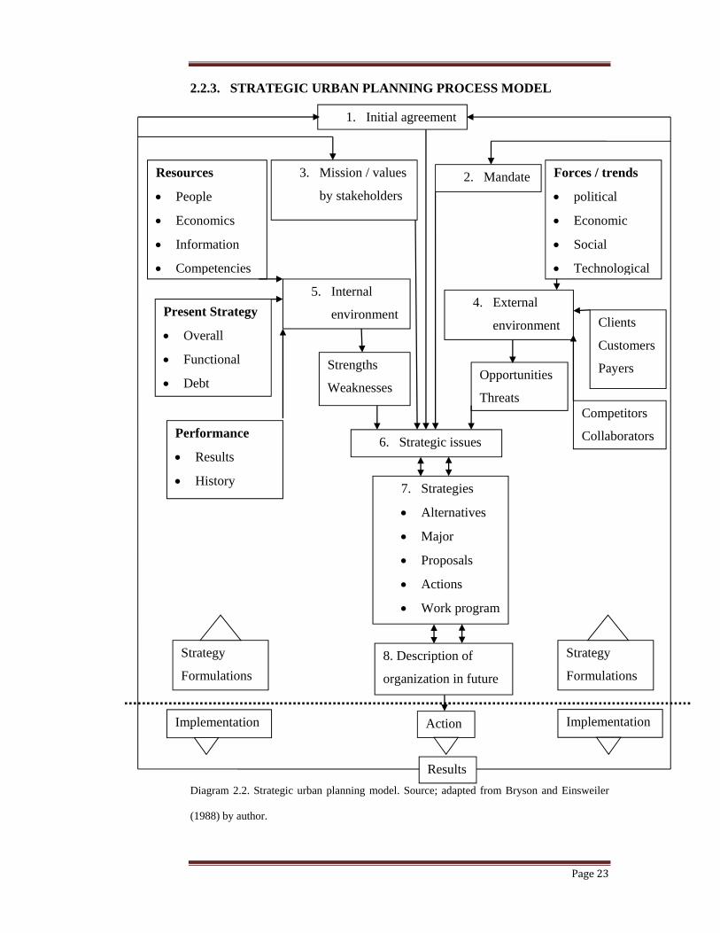
Figure 2.6. Plan of Chandigarh Source http:// chandigarh.gov.in
2.3.5. MILTONE KEYNES
One very famous use of the grid system was in the British new town of Milton
Keynes. In this planned city, which began construction in 1967, a system of
ten horizontal and eleven vertical roads at 1 km intervals was used with
roundabouts at each intersection. The horizontal roads were all given names
ending in 'way' and H numbers (for 'horizontal', 'e.g. H3 Monks Way). The
vertical roads were given names ending in 'street' and V numbers (for vertical',
e.g. V6 Grafton Street). Each grid road was spaced roughly one kilometre
along from the next, forming squares of approximately one square kilometre.
Each square and roundabout was given its own name. The system provided
very easy transport within the city, although it confused visitors who were
unfamiliar with the system. Note the 'grid squares thus formed are far larger
than the city blocks described earlier, and the road layouts within the grid
squares are generally 'organic' in form — matching the 'street hierarchy model
described above. A one square km sector in Milton Keynes framed by major
roads on a grid configuration. The road network within the sector uses cul-de-
Page 46
Page 30
sac streets complemented by bike and foot paths which connect the entire
sector and beyond
Figure 2.7. A one square km sector in Milton Keynes framed by major roads on a
grid. Source http://en.wikipedia.org/wiki/Grid_plan
2.4. STREETSCAPE DESIGN:
All too often “streetscape design decisions are made in isolation treating the
streetscape as residual space” (Eichner & Tobey, 1987: p. 276). Concern over
this issue was raised as far as 1927 when Clarence Stein, while designing
Radburn in New Jersey, proposed a “radical revision of relation of houses,
roads, paths, gardens, parks, blocks, and local neighborhoods”. During the
1970’s and early 80’s, Appleyard made powerful and influential arguments
against auto-centric design with his research relating to traffic and
transportation to significant impacts on quality of life (Appleyard, 1981).
2.4.1. THE WOONERF
Woonerf principles advocate for shared spaces with literature emphasizing the
use of “gateways” at transition points (Hamilton-Baillie, 2004; Pressman,
1987). Features such as road texture, width, lighting, and alignments change
to emphasize the new driving context and encourage the driver to engage with
Page 47
Page 31
his or her surroundings. The Woonerf therefore accommodates cars yet makes
them feel fundamentally unwelcome” (Pressman, 1987).
I) Safety
There is significant qualitative research suggesting that pedestrians and
cyclists discomfort quickly rises adjacent to traffic traveling faster than 32
km/h (Hamilton-Baillie, 2004). As a result, most Woonerf schemes depend on
very low speed limits (usually 30 km/h). As mentioned, the British
Government found that “no accidents at all had been recorded on shared
surface roads” (Department of the Environment & Department of Transport,
1992: p. 13 cited in (Biddulph, 2003).
II) Spirit of Place
Effective Monderman design demands consideration of local history,
architecture, movement patterns and urban form to seamlessly integrate the
surrounding buildings, roadways, and landscape (Hamilton-Baillie, 2004).
Monderman advocates using public art at gateway’s marking entry and exit
points to the redeveloped streets. Hierarchy, and priorities are essential to the
functioning of public space, it appears that speed may be a factor in urban
quality in a wider context than simple safety and accident reduction.
(Hamilton-Baillie, 2004).
2.5. URBAN PUBLIC SPACES
Nowadays, the concept of “public space” in complex urban matrix is not
limited only to the urban parks and preserves but also non park-non-natural-
places. Public spaces such as streets, school yards, outdoor sport complexes,
cemeteries, and public squares are important open spaces (Hall, 1998). These
Page 48
Page 32
areas are open to full spectrum of the society and their sound planning and
design make them more attractive.
Baines (1999) recognizes the value in waste lots, the derelict, and gap sites
awaiting redevelopment but not currently managed. According to Thompson
(Thompson; 2002) these areas are indeterminate areas of open space and these
function specific spaces are as much necessary as decorative parks.
Ecologically sound planning and design of such spaces aids in establishing
ecological networks (Cook, 2000, Cook 2002) in the urban matrix. Chiesura
(2004) suggests taking into account the variability in the open space types to
fulfill the needs and expectation of all the segments of the population.
Non-domestic physical sites that are distinguished by their relative
accessibility such as dance clubs, parks, restaurants, bars, cafes, the street, etc.
(Lofland, 1998; McCarthy, 2001) have also been considered as public spaces.
While some would delimit public spaces to non-commercial physical sites of
congregation like parks or plazas (Carr 1992). As Zukin (1995) argues, there
is an increasing commodification of public spaces in urban centers; thus using
a broader definition of public space, which includes semi-public sites of
consumption, more accurately reflecting the everyday practice of urban life
away from home and work.
2.6. ZONING:
According to Abeles, the term “zoning” denotes the process of dividing a
community into a set of distinct zones in which specific land uses are either
allowed or prohibited (Abeles, 1989). Local governing bodies (county, city,
town, townships, etc.) prescribe regulations for each zone addressing three
general issues: Use, Intensity, and Bulk (Kelly, 1993). For each zone,
Page 49
Page 33
ordinances indicate allowed (“of right”), special (“conditional”), and
prohibited uses. The underlying objective seeks to keep incompatible uses
apart from one another.
Zoning also regulates building intensity. Intensity refers to the amount of a
particular use on a designated piece of land. Floor-area ratios (FAR) regulate
intensity for commercial and industrial zones. For all intents and purposes, the
FAR acts as a multiplier (Barnett, 2003).
Bulk refers to the actual volume of space or massing of a building. Building
setback regulations and maximum building coverage requirements address
bulk issues (Kelly, 1993). Height restrictions may also be used to regulate a
building’s bulk.
2.6.1. ZONING SUCCESSES:
Zoning proved an appropriate governmental policy response to combat the ills
of early industrial cities. A functionalist interpretation of land use emerged,
with each distinctive function placed in the appropriate zone (Wickersham,
2001). Its structure allows for development predictability, certainty, and
administrative accountability and objectivity Kwartler (1989) and protects
both personal property investments and public rights. Zoning’s inflexible
regulations pledge accountability. It provides direct land use control at the
most local of levels (Gordon and Richardson, 2001). Finally, zoning costs
virtually nothing to municipal governments (Levy, 1995). Aside from basic
administrative costs or occasional legal costs, zoning proves far cheaper than
public ownership of land or the purchase of easements, which could instill the
same amount of control or greater (Levy, 1995).
Page 50
Page 34
2.6.2. FAILURE OF ZONING:
Euclidean zoning’s framework separates, for the most part, residential and
commercial uses. Critics of zoning argue that the separation of these basic
daily uses, albeit well intentioned, manifests itself as sprawl (Wilson, et al,
1998; Wickersham, 2001). The very ordinances designed to protect citizens
from bad development, actually prevent the creation of good neighborhoods,
towns, and cities (Ferrell & Madden, 2002).
Jane Jacobs (1961) argues that zoning is overly rigid in dividing cities into
uniform, low-density, singular-use districts. Conversely, zoning has been
overly soft (or permissive) in its failure to establish design standards for
streets and buildings that would promote interaction within the public realm.
Further, many suggest that current zoning ordinances are incomprehensible to
the common citizen, and require legal expertise to decipher. Finally, zoning
impedes the creation of mixed-use development. As such, “livable
communities” are impossible to create.
2.6.3. ALTERNATIVE TO TRADITIONAL ZONING:
In an effort to create more livable communities based upon good urban design
practices within the framework of traditional Euclidean zoning, planners have
created new tools to augment or replace current development regulations.
Some of these tools include: bonus/incentive zoning, inclusionary zoning, the
transfer of development rights (TDR), planned unit developments (PUD),
cluster zoning, performance zoning, and the form-based code (FBC).
2.6.4. FORM BASED CODES:
Form-Based Codes represent multi-disciplinary codes that connect the design
of circulation and public space networks to the design of building form
Page 51
Page 35
(Altman, et al, 2003). They regulate fewer elements than typical zoning
regulations because the provisions do not constrain every possible
combination of setback and density (Dover, 2003). As Form-Based Codes
consider physical design to be paramount, these codes specify through graphic
illustrations what types of development are most appropriate for a particular
area (Dover, 2003). Most often, this includes building alignment on the street,
the space between buildings, and relative heights, which are expressed as
ranges of acceptable values.
The Form-Based Code functions as a template whereby having clear controls
on building form, landowners and their neighbors can easily predict what
future development would look like (Chael, 2003; Ferrell & Madden, 2002).
Design standards directed by FBC do not limit a building’s usage (Kucharski,
2003). Because use is a secondary consideration, the market directs the
appropriate use to the site based upon the prescribed building form.
To achieve the community vision, experienced code practitioners lead
stakeholders in what is called a “charrette.” A charrette is the process by
which local stakeholders develop a physical plan for their community. In
doing so, community members are provided with maps of the areas and
divided into working groups. These groups then use the maps to explain in
great detail what they would like to see developed or preserved (Dover, 2001).
The charrette helps to ensure that the proposed plan is feasible, assists in
formulating a consensus among key stakeholders, including residents, major
institutions, government officials, developers, and builders; about expected
objectives of the physical plan. (Baltimore County, 2003). The Form-Based
Code then codify this community-based physical plan
Page 52
Page 36
I) Components of FBC
Form-Based Codes usually consist of three primary components (and one
optional component) that are employed to implement a community’s vision-
based physical plan. These components include: Regulating Plan, Building
Envelope Standards, Definitions, and the optional Architectural Standards
(Katz & Ferrell, 2003).
a) The Regulating Plan
The Regulating Plan provides the coding key for the building envelope
standards, and specific information for the character of each building site
b) Building Envelope Standards
The Building Envelope Standards guide basic parameters regulating building
form. These parameters are illustrated in a series of cross sections specifying
key dimensions (Katz, 2003; Katz & Ferrell, 2003), height, siting, elements,
and uses.
c) Definitions
This component allows for a full explanation of all vital design elements of
the Form-Based Code. Items included in the definitions section are used in
very specific ways, and may differ from common usage interpretations (Katz,
2003; Katz & Ferrell, 2003).
d) Architectural Standards
Architectural Standards relate primarily to aesthetics of a community, and are
only included in a Form-Based Code at the discretion of the local stakeholders
(Katz, 2003; Katz & Ferrell, 2003). Admittedly, architectural standards also
prove to be very subjective, which explains why property owners may be
reluctant to engage in such an agreement.
Page 53
Page 37
Other components that can be included in FBC include public space
standards, administration, landscape standards, signage standards,
environmental resource standards and annotations.
II) Applying Form-Based Codes
Four components are necessary to the successful implementation of a Form
Based Code (Lewis, 2003). First, clear and concise standards specifically link
design standards to measurable objectives and results. Secondly, Form-Based
Codes should be style neutral. This prevents “over-designing” a particular
community. Generally, Form-Based Codes represent a more permissive style
than conventional appearance regulations associated with zoning. “Good
urbanism can triumph bad architecture,” (Lewis, 2003). Thirdly, codes should
be easily understood. Simple graphics and photos of acceptable parameters
lend support to good codes. Finally, permitting should be streamlined.
Controlling an efficient and predictable permitting process saves times and
money for all parties.
Form Based Codes can be incorporated into local government’s development
regulations through mandatory codes, optional (parallel) codes and floating
zone codes. In mandatory codes the FBC can be contained within a planning
document called a “specific plan” which can completely override the zoning
ordinance for a given geographical area. Compliance is required. Optional
(parallel) codes serve as an alternative to current zoning but does not replace it
and compliance is voluntary. A floating zone code does not contain a
regulating plan but includes instructions and standards for developers to
follow when they prepare a regulatory plan for their property.
Page 54
Page 38
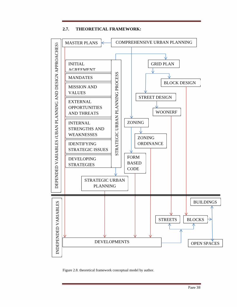
2.7. THEORETICAL FRAMEWORK:
Figure 2.8. theoretical framework conceptual model by author.
MASTER PLANS
DEVELOPMENTS
STRATEGIC URBAN PLANNING
COMPREHENSIVE URBAN PLANNING
INITIAL AGREEMENT
MANDATES
MISSION AND VALUES
EXTERNAL OPPORTUNITIES AND THREATS
INTERNAL STRENGTHS AND WEAKNESSES
IDENTIFYING STRATEGIC ISSUES
DEVELOPING STRATEGIES
ST
RA
TE
GIC
UR
BA
N P
LA
NN
ING
PR
OC
ES
S
ZONING
FORM BASED CODE
ZONING ORDINANCE
GRID PLAN
STREET DESIGN
WOONERF
BLOCK DESIGN
BLOCKSSTREETS
BUILDINGS
OPEN SPACES
DE
PE
ND
ED
VA
RIA
BL
ES
(U
BA
N P
LA
NN
ING
AN
D D
ES
IGN
AP
PR
OA
CH
ES
) IN
DE
PE
ND
ED
VA
RIA
BL
ES
Page 55
Page 39
2.8. SUMMARY
The choice of literature that was reviewed in this dissertation depended on the
urban planning and design approaches used in the study area. This included
comprehensive urban planning through strategic urban planning approach,
grid planning and zoning.
Comprehensive urban planning which was the earliest urban planning
approach has evolved to current strategic urban planning which is mostly used
by Municipalities amongst other urban planning approaches. The process of
urban strategic planning is very important to ensure fruitful results in urban
planning and design.
The grid plans was used from the ancient Greek and Romans for its
practicality in military for troops movement. It’s used in urban planning and
design has been emphasized over time including Barcelona Eixample, by
Ildefons Cedar, Urban planning and design of Chandigarh, by Lecorbusier and
that of Miltone Keyness. To curb the problems of long distanced traveled in
Grid plans, movements like the city beautiful came up introducing diagonals
on existing grid plans. This was proofed impractical due to destruction when
introducing the diagonals on existing urban structure. Congestion at
intersections could be resolved by creating over passes or underpasses. In
relation to grid planning, the researcher reviewed current trends in the design
of streets and public spaces and reported on the woonerf approach of design.
The study area also uses zoning ordinance to guide private developments. The
literature reviewed showed that current trends in urban planning and design
are utilizing form based codes along with zoning ordinances for a more
implementable approach in guiding urban developments.
Page 56
Page 40
3. CHAPTER THREE: METHODOLOGY.
3.0 INTRODUCTION:
A research method can either be qualitative or quantitative. In qualitative
research studies that do not attempt to quantify their results through statistical
analysis are undertaken. Qualitative research involves interviews and
observations among other research instruments without formal measurements
(Marczyk 2005). This chapter describes the methods that were applied in
carrying the research study. The strategy used in this research is case study
whereby an in depth study of urban planning and designing Eastleigh District
Commercial Centre has been done. See appendix 01 of a case study protocol
adopted for the study
3.1. RESEARCH DESIGN:
The function of research design is to provide for the collection of relevant
evidence with minimal expenditure of effort, time and money Kothari (1985,
P.17). The research design used in this study was exploratory whereby the
urban planning and design methods; including comprehensive urban planning
in form of strategic urban planning, grid plan and zoning ordinances, used in
guiding the development of EDCC were explored against the contemporary
developments of EDCC and theoretical background of strategic urban
planning, grid planning and zoning. The study focused on two units of
analysis, the 2008 policy plan and the current zoning ordinance of zone 2.
3.2. TARGET POPULATION:
Eastleigh District Commercial Centre was delineated in the 1989 policy paper.
The centre comprises of both physical and social infrastructure whose current
Page 57
Page 41
development guidelines are contained in the 2008 policy paper. Development
of buildings found in this area is guided by zone two zoning ordinances.
The study was on urban planning and design of EDCC which is manifested in
physical infrastructure, social infrastructure and buildings in the area. Simple
random selection method of physical infrastructure elements like roads and
drainage system, water and sewerage system and waste disposal was done to
be utilized in this research. The same was done for social infrastructure
elements including education facilities, health facilities, housing and markets.
Buildings for study and analysis were also chosen randomly.
3.3. DATA COLLECTION INSTRUMENTS:
According to (Kombo and Tromp, 2006 P.99), data collection refers to the
gathering of information to prove a point. The procedure employed in data
collection during the study were; primary and secondary data. Primary data is
firsthand information, collected afresh and for the first time. While secondary
data are those from previous studies conducted on the same or similar to the
study and act as guides in the study. Secondary data was important in the
theoretical understanding of the study. Interviews were used to provide
qualitative insight into the data thereof collected. These qualitative insights
were used for elements that don’t have standard measures like opinions.
Observation, sketching and photography during physical survey of the study
area were more instruments utilized during this research. Secondary research
instruments including literature review of published and unpublished data
were also used.
A summary of the data collection instruments used in the research are
presented below
Page 58
Page 42
Table 3.1. Data collection instruments
INSTRUMENT DATA NEEDS DATA
SOURCE
VARIABLE
ACCESSED
Interviews
observation:
Efficiency of physical
infrastructure in EDCC
as recommended in the
2008 policy paper
NCC
Site plans
GIS maps
Photography
Sketches
Architectural
drawings
Road and drainage
system
Water and sewerage
system
Solid waste management
Efficiency of social
infrastructure in EDCC
as recommended in the
2008 policy paper
Business activities space
Education facilities
Health facilities
Housing facilities
Markets facilities
Buildings compliance
with zone 2 zoning
ordinance
Plot ratio
Plot coverage
Building line
Lot sizes
Table 3.1. Data collection instruments by Author.
3.4 DATA COLLECTION PROCEDURE
Following the aforesaid data collection instruments and items, secondary
research was initially undertaken to provide basis for the primary research. A
review of the urban planning and design approaches used in EDCC was
undertaken establishing that in urban planning and design of EDCC
comprehensive urban planning, strategic urban planning, grid planning and
Page 59
Page 43
zoning ordinances are used. Literature review of comprehensive urban
planning, strategic urban planning, grid planning and zoning were then
undertaken guided by the established urban planning and design approaches in
EDCC.
This background was used to develop a research model which was used in
primary data collection. I based my interview elements for primary research
on this background which were a question and answer session consisting of a
list of specific questions. All the questions where about the efficiency of
physical and Social infrastructure as planed in the 2008 policy paper and
compliance of private developments to EDCC zoning ordinance.
The interviewer did not deviate from the list or inject any extra remarks into
the interview process. I encouraged the interviewee to clarify vague statements
or to further elaborate on brief comments. I tried being objective and did not
influence the interviewer's statements. I did not share my own beliefs and
opinions. I used maps, photographs and sketches from field survey as the
check list for the answers provided in the interview.
3.5. CONCEPTUAL FRAMEWORK:
The following conceptual framework was a tool used by the researcher to
develop awareness and understanding of the situation under scrutiny and to
communicate the same. Urban planning and design of EDCC is manifested in
the provision of Physical and social Infrastructure as recommended in the
2008 policy paper and the buildings found in EDCC as guided by the zoning
ordinance for EDCC in zone two. The elements studied under physical
infrastructure, social infrastructure and buildings are presented in the model.
Page 60
Page 44
In this conceptual framework, the researcher has developed a relationship of
variables in the study. There are two major variables: independent and
dependent variables. The independent variables are the causes which are factor
that explain variations in the dependent variable while dependent variable is
the outcome the research is attempting to predict or explain (Kombo and
Tromp 2006 p.21). In the current study, social infrastructure, physical
infrastructure and buildings are the independent variables while urban
planning and design of EDCC is the dependent variable.
Independent Variable Developments Depended Variable
Diagram 3.1. Research variables by author
3.6. DATA ANALYSIS:
In this research, data analysis entailed data verification and representation
which was done through qualitative analysis. According to Yin (2003),
familiarity with various tools and manipulation techniques in case study is
helpful. Each case study should have a general analytic strategy defining
Education facilities
Health facilities
Housing facilities
Markets facilities
Plot ratio
Plot coverage
Building line
Lot sizes
Road and drainage
Water and sewerage
Solid waste
Urban planning and
design of EDCC
Physical
infrastructure
Social
infrastructure
Buildings
Page 61
Page 45
priorities for what to analyze and why. Yin (2003) highlighted three strategies
including theoretical propositions, rival explanation framework and
developing case descriptions. This research relied on theoretical propositions
strategy.
3.6.1. QUALITATIVE ANALYSIS
This form of research involved description seeking to describe and analyze
urban planning and design of EDCC. Qualitative research was appropriate to
emphasize the development of EDCC in disregard to the urban planning and
design framework for the zone. This included computation of maps,
photographs, diagrams and textual write-ups, designed to refine and distill the
data collected. Data analysis techniques used are as follows;
3.6.2. CONTEXTUAL SPATIAL ANALYSIS
This involved physical mapping of EDCC using geographical information
system (GIS), site plans sketches and photographs to bring out the site plan of
the Commercial Centre with the developments which have come up in the
Commercial Centre.
3.6.3. DESCRIPTIVE ANALYSIS:
A description of the development process for 2008 policy paper was done
following strategic urban planning process highlighting areas that needed
improvements to enable implementation of the policy plan. In addition, a
description of the ways in which the EDCC zoning ordinances are violated
using the plot coverages, plot ratios, building lines, setbacks and lot sizes in
EDCC .
Page 62
Page 46
3.7. DATA PRESENTATION
The collected data is presented using architectural graphics based on the
planning standards and building controls established from the literature
review. The presentation covers planning and building elements with cross
sections of roads, buildings, urban profiles; development perspectives and
maps.
Page 63
Page 47
4. CHAPTER FOUR: RESEARCH FINDINGS:
4.0. INTRODUCTION:
The data collected and analyzed is presented in this chapter in three sections.
The first section is the empirical data on policy plans and zoning ordinances
for the study area. Collected data is analyzed and reported on the process of
developing the policy plans in the study area with emphasis on the 2008
policy plan which is the most current. The process of developing the 2008
policy paper is analyzed against the strategic urban planning process from
literature. The second section presents data collected and on the 2008 policy
plan and analyzed against the data collected on the current infrastructural
development of the study area. The third section presents a comparative
analysis of the data collected on the zoning ordinances against data collected
on a sample of buildings in the study area.
4.1. URBAN PLANNING AND DESIGN OF EDCC:
4.1.1. POLICY PLANS:
I) Initial policy plans
The policy framework that has over the years guided development in
Eastleigh can be traced back to 1959 when the then City Council of Nairobi
realized the need to come up with a definite policy regarding establishing of
commercial enterprises in the area. In the initial period the concern was with
the demand for land to accommodate the commercial activities which had not
been planned for as well as responding to the needs of the growing population.
The continued growth led to a policy on extension of the commercial area in
1968 in Minute no 9 of 11th December, 1968.
Page 64
Page 48
II) Minute No. 38 of 23rd November, 1984
This policy envisaged a catchment population of 200,000 people by the year
2000 that would depend directly on Eastleigh for their shopping needs. It had
been observed that Eastleigh Area was experiencing rapid growth particularly
in commercial activities. This called for policy intervention for purposes of
sustainable development recommending that: the existing linear commercial
development in Eastleigh to be left intact, but further ribbon development to
be discouraged and curtailed; Commercial development to be confined within
the nucleated centres indicated on the plan; supplement the proposed
commercial centres by maintaining plots fronting Juja Road to serve the
nearby Mathare and Huruma areas; servicing of the plots fronting Juja Road
to be from the back lane to avoid traffic congestion along Juja Road; Traffic
flow along 1st and 2nd Avenues and other nodal centres to be reorganized;
street parking to be provided and road widening to be carried out as was
indicated on the plan; Plot ratios and ground coverage to be increased from
0.75 and 0.35 to 1.5 and 0.6 respectively so as to limit the height of the
buildings to a maximum of four floors and the former Eastleigh Treatment
Plant site to be developed for Primary school and high rise residential
accommodation.
III) 1989 POLICY PLAN:
The role of Eastleigh as explained above was re-emphasized by the Eastleigh
District Centre strategy of 10th May, 1989. It was recommended that the area
bounded by Muratina Street to the West, General Waruingi Street to the
South, 82 Air force to the East and Juja Road to the North be declared the
District Centre for Eastlands. This centre was meant to accommodate low
Page 65
Page 49
level commercial activities that could not find a place at the CBD. It was
estimated that a population catchment of 432,000 was adequate to support a
Secondary Commercial centre. Various recommendations were made for
expansion of infrastructure and specifically roads to be able to support these
commercial activities. The policy recommended various measures such as
setbacks and road widening, which were specific for certain road.
IV) 2008 POLICY PAPER
A collaborative approach was employed were private pubic partnership was
used in determining the contributions, limitations and flows of previous policy
plan, current problems and strategies to combat them with actors drawn from
the partnership.
a) Initial agreements
2008 policy plan was to steer the development of Eastleigh as an integrated
secondary centre by Nairobi City Council.
b) The stake holders involved:
The Nairobi City Council department of forward planning was the planning
team. It involved other stake holders in the planning process including
community leaders, Landlords, tenants, Business men, Matatu drivers,
Religious Institutions, Community Base Organizations (CBO), General public
and the council staff in the wards and local levels.
c) Mandates:
Different groups have got mandates imposing their will on the planning team:
Page 66
Page 50
i) Political arena:
This was represented by the Mayor and elected Councillors within the study
area and other departments within NCC including forward planning, City
Engineering and environmental departments.
ii) Private arena:
The mandates of the private stakeholders was represented by community
leaders, Landlords, tenants, Business men, Matatu drivers, Religious
Institutions, Community Base Organizations (CBO), General public
iii) Legally established procedures
The Local Government Act Cap 265 of the laws of Kenya passed by the
national assembly in 1977 regulates planning in local authorities. It allows
local authorities that have public works, town planning and markets
departments to handle planning, control and regulation of land use; buildings
and development control; roads and bridges, public access; traffic signs;
packing controls; preparation of strategic plans, planning and design of
markets. Hence this mandates the Nairobi city council to prepare strategic
plans for the area it has jurisdiction over.
iv) Existing policies
The planning team depended a lot on the prior policies including Minute No. 9
of December, 1968; the 1984 policy plan and the Eastleigh District center
strategy of 10th May, 1989.
d) Mission and values
The missions and values of the planning team were consolidated and
presented in the 2008 policy plan.
Page 67
Page 51
e) External Opportunities and threats
i) Lack of financial control:
Former policies had failed partly due to lack of budgetary support from the
government structures hence lack of financial control was a major external
threat to the planning team.
ii) Competition with other government organs and private organizations:
The type and quality of housing and commercial facilities being provided by
the private sector are posing high competition to the planning team because of
their limited resources.
f) Internal strengths and weaknesses
i) Resources inputs:
The planning team utilized dons from the University of Nairobi in the research
to add on the skilled force in the planning process.
ii) Internal coalitions:
Poor internal coalitions e.g. the city engineer was not aware of the planned
reorganization of the traffic and referred the researcher to Kenya Urban Roads
Authority; affected the implementation of the planned policy.
g) Identifying strategic issues:
The strategic issues that were identified by the planning team covered
physical and social infrastructure including the following:
1. PHYSICAL INFRASTRUCTURE:
i. Road network & Drainage system
The policy outlined problems of traffic congestion, narrow roads, poor state of
roads, inadequate parking space, poor drainage network and poorly defined
pedestrian walkways. His had been caused by encroachment on road reserves,
Page 68
Page 52
on-street loading and offloading, lack of road widening and expansion, trading
on road reserves, undisciplined road use by public transport, lack of pedestrian
walkways and lack of investments on roads and drainage.
ii. Water & Sewerage network
The policy identified the problem of pollution, contamination and water loss
due to leakage and burst of water pipes and sewers, irregular supply of water,
low expansion of water and sewer network. It had been caused by lack of
regular maintenance of the system, inadequate coordination between demand
& supply actors, lack of investments in water & sewer systems and illegal
water use.
iii. Solid waste
There was lack of adequate waste dumping sites, inadequate waste
management systems in entire area and indiscipline of residents in dumping of
wastes which had been caused by increased waste generation by growing
population, lack of investment in waste disposal services, inefficient waste
disposal service delivery and negative attitude by residents on waste
management.
2. SOCIAL INFRASTRUCTURE
i. Economic Base and District Centre
There was a problem of inadequate space for business activities, high rate of
growth and new upcoming business enterprises and encroachment of informal
and formal business activities on road reserves & service lanes. These were
caused by encroachment on planned areas for business activities, failure to
acquire requisite planning permission and high demand and supply of goods
and services due to low commodity prices.
Page 69
Page 53
ii. Housing
There were inadequate housing units, disregard to building & construction
standards, encroachment by buildings on road reserves, high costs of rent and
informal settlements. The causes for the above was found out to be high
demand due to increased population growth, weak enforcement of building
regulations, urban poverty, high cost of housing construction and inadequate
land for new housing investments.
iii. Education
The policy document highlighted that there was inadequate educational
facilities, unregulated mushrooming of private schools and informal schools,
inadequate land for provision of new and expansion of schools and poorly
maintained & old structures. Such had been caused by encroachment on land
planned for educational facilities, weak enforcement of standards regarding
schools development, lack of maintenance & upgrading of old existing
educational facilities, a rapidly growing population and free primary
education.
iv. Health
The health sector had problems of inadequate health facilities, unregulated
mushrooming of private health facilities, poorly equipped health facilities,
perennial inadequate water supply in some of the health facilities and high
demand. This had been caused by high population, weak enforcement of the
standards guiding establishment of health facilities and inaccessibility due to
poor roads.
Page 70
Page 54
v. Markets
There were inadequate market facilities and congestion in the existing markets
because of encroachment on land planned for markets and a large population
served by Eastleigh commercial centre.
h) Developing strategies:
The strategies there of developed addressed the physical and social
infrastructural services including:
1. PHYSICAL INFRASTRUCTURE:
i. Road network & Drainage system
The policy proposed to revitalize the road and drainage network system for
efficient functioning through investments in roads and drainage by
undertaking comprehensive road widening, repair and maintenance of
dilapidated roads & expansion and drainage network, reclaiming all road
reserves and parking spaces, construction and provision for elaborate
pedestrian and cyclist paths. This was to be acted upon by city Engineer, city
planning, developers and community initiatives.
ii. Water & Sewerage network
The policy proposed to upgrade the water and sewerage system to acceptable
standards commensurate to demand through undertaking new investments in
expansion of water and sewerage network, stopping all illegal water and sewer
connections and use and establishing an efficient regular maintenance
mechanism. The above was to be achieved by NCC, NAWASCO, residents,
business community and Athi water
Page 71
Page 55
iii. Solid waste
The policy undertook to improve and re-establish effective and functional
solid waste management systems for a healthy environment by Engaging
community-based initiatives on waste management, promoting use of
desegregation of waste, applying the three Rs (reduce, recycle, and re-use),
strengthening private solid collection systems and arrest illegal dumping. The
above was to be carried out by environment department in city Planning,
private waste collection companies, business community and residents.
2. SOCIAL INFRASTRUCTURE
i. Economic Base and District Centre
The policy had an objective of streamlining the economic activities and
operations on space and strategized on constructing of markets within the
District centre, strict enforcement of planning law and regulations and
implementation of road widening and parking proposals of previous policy.
This was to be acted upon by NCC, traders associations, residents and
entrepreneurs
ii. Housing
The policy objectified to restore and establish sustainable and standard
housing provision mechanism through promotion of the use of low-cost
housing development, strict implementation/enforcement of building codes,
facilitate upgrading of informal settlements and densification of public
housing areas. This was to be implemented by City Planning, Social Services,
Ministry of Housing, Non-Governmental Organizations, residents and private
developers
Page 72
Page 56
iii. Education
The policy objectified to enhance provision of adequate and quality
educational facilities demanded by the population. Such would be achieved
through claiming land planned for expansion of educational facilities,
allocation of more land for expansion of educational facilities, strict
enforcement of standards for establishment of educational facilities and
upgrading & maintain existing facilities. The NCC, MoE, MoH, MoW,
residents and private investors would ensure the above happened
iv. Health
The policy proposed to enhance/facilitate provision of adequate and quality
health facilities to serve the escalating population by upgrade some of the
existing health facilities to provide specialized services, strict enforcement of
the licensing standards and establishment of new health facilities. City
Planning, MoH, NGOs, Private investors and CBOs were responsible for
ensuring the policy strategy is achieved.
v. Markets
The policy undertook to provide system of adequate functional markets by
protecting spaces planned for markets, acquisition of more spaces through
purchase by City Council for markets, Public Private Partnerships in provision
of markets and upgrading the existing markets to accommodate more business
enterprises. This would be acted upon by City Planning, Social Services,
residents, private developers, Ministry of Nairobi metropolitan and Ministry
of Local Government.
Page 73
Page 57
4.1.2. ZONING
The department of City planning in NCC has developed a guide of Nairobi
City Development Ordinance and Zones with a summary of planning
ordinances to ensure that development control, and indeed the wider planning
agenda is being implemented effectively across the city. In this Summery
EDCC is part of Zone Two with the following Ordinances:
Table 4.1. EDCC zoning ordinances.
Zone Areas covered GC
%
PR
%
Type(s) of development
allowed
Min. Area
(Ha)
2 Eastleigh
District Centre
80 250 Commercial / Residential
(High-rise flats)
0.05
Table 4.1. EDCC zoning ordinance adopted from NCC, City planning department by author.
4.2. DEVELOPMENTS IN EASTLEIGH DISTRICT
COMMERCIAL CENTRE:
4.2.1. PHYSICAL INFRASTRUCTURE:
1. ROAD NETWORK AND DRAINAGE SYSTEM
The road network of the study area is planned in a grid system with a
hierarchy of the network width sizes. Drainage system is set along the road
networks.
The 2008 policy plan found there was traffic congestion, poor drainage system
with narrow roads and inadequate parking space. The plan proposed widening
and repair of the system, reclamation of road reserves and parking spaces,
construction and provision for pedestrian and cyclist paths. They also
Page 74
Page 58
proposed a reorganization of the traffic flows as proposed in the former policy
plans road system.
The researcher set out to establish if the above proposals were implemented
and the analysis is as follows:
The road network of the whole study area is represented below
Figure 4.1. Road network for Eastleigh District Commercial Centre. Digitized by author from
GIS maps.
Gen
eral
War
uigi
Kir
ongo
thi
M. J
acks
on M
urii
thi
C. M
uing
ai
1st A
venu
e
2nd
Ave
nue
S. Kahande St.
KipandeAthumani St.
S. M. Kamugobe St.
M. Kinyanjui St.
G. Waruigi St.
Juja Road
12th St.
11th St.
10th St.
9th St.
8th St.
6th St.
5th St.
Galole Rd.
4th St.
Muyuyu ave.
3rd St.
2nd St.
Busagwa Ln.
Mukunga
G. Waruigi St.
3rd
Ave
nue
Page 75
Page 59
a) Design and traffic reorganization.
An interview with the Roads City Engineer in CCN reviled that, the engineer
was not privy to the proposed reorganization of traffic in EDCC. Instead, he
referred the researcher to Kenya Urban Roads Authority saying that KURA
had embarked on rehabilitation of the road networks in the study area and the
researcher carried out a site survey of the same.
Figure 4.2. Rehabilitated General Waruingi street. Source: Photographed by author
As depicted in the illustrations above, KURA is constructing marrum roads
with open drains at the side. These roads will not be usable after a rain season
hence the performance of the same is questionable. It is evident that
construction and provision for pedestrian and cyclist paths is not being done.
It is also evident that design of drainage system is completely neglected.
Figure 4.3. Drainage system at junction of first and Fifth Avenue by author
Page 76
Page 60
Nevertheless, KURA is redeveloping First Avenue, Second Avenue and
general Waruinge road to good standards using cabro as illustrated in the
pictures below.
Figure 4.4.Rehabilatation of Second Avenue. Photograph by author
Figure: 4.5. Rehabilitation of General Waruinge road. Photograph by Author
Page 77
Page 61
b) Motorized transport
Eastleigh is served by public transport vehicles with a terminus at Garissa
Lodge mall in First Avenue, St. Teresa and Mlango Kubwa in Juja road as
illustrated below. Having only one drop off and pickup point is insufficient
therefore picking and dropping of people happen on the roads especially
along general Waruige road and first avenue. This results to traffic congestion
in these particular roads. Muratina road is also being used as a public transport
road after renovations by Kenya Urban Roads Authority.
Figure 4.6. Motorized transport system in Eastleigh to the CBD. Source:
www.Jambonairobi.co.ke/area-guide/eastern-suburbs/eastleigh/
Page 78
Page 62
c) Non-Motorized circulation
In the 2008 policy paper for development in Eastleigh, the need for NMT was
proposed. A project launched by KURA in 2012; whose construction will be
completed after 2013 is said to contain footpaths on either side
(www.kura.co.ke) with no bicycle lanes as envisaged in the 2008 policy plan.
d) Encroachment
An interview with an assistant development control official in the City
Council reviled that, one of the challenges they face in controlling
development in area is the failure of the developers to give 1.5 meter
surrenders as required by planning policy in fear of losing their right of land
ownership.
A tour through the study area reviled that, several roads are overgrown with
weeds and are impassable. Informal businesses have encroached on to the
road reserves rendering them unusable.
Figure 4.7. First Avenue encroachment by hawkers. Photograph by author
Page 79
Page 63
2. WATER AND SEWERAGE:
The developers and Architects the researcher interviewed indicated that water
provision was not adequate hence bore holes were being drilled. The City
Council sewer is being used for the sewerage system of the study area.
3. SOLID WASTE MANAGEMENT:
The interviews showed that there were no mechanisms for Solid waste
disposal by the city council hence solid was being disposed privately. The
institutions like Easleigh High School was burning away the refuse and
decomposing the decomposable part of the waste. This is despite the 2008
policy plan proposing to employ the three Rs; reduce, recycle and reuse. None
of the three R’s has been implemented.
Figure 4.8: Dumping along Major Jackson Muriithi road. Photograph by author
Page 80
Page 64
4.2.2. SOCIAL INFRASTRUCTURE
1. ECONOMIC BASE AND DISTRICT CENTRE
Economic activities and operations of space are not yet complete. The CCN is
physically chasing away hawkers from the road reserve.
2. HOUSING AND SOCIAL AMENITIES
The strategy of providing low cost housing developments in the area has not
been implemented yet nor has the process started.
3. INSTITUTIONS (EDUCATION AND HEALTH FACILITIES
The strategies to address the problems of scarcity of institutions have not yet
been accomplished including reclaiming land made for the institutions,
expansion of the institution facilities and upgrading of the existing facilities.
4. MARKETS
There exists some land hoarded for community market on site. The researcher
visited the site and was informed that the land had been sold by City Council
of Nairobi to a private developer and now the new owner was planning to
develop a shopping mall. This was despite the fact that a huge sign post
depicting that the site was for hawkers market being developed through
Private Public Partnership between the NCC and a Private developer.
Hawkers are using the road reserves to market their wares especially on First
Avenue.
Page 81
Page 65
Land for CCN market that is already sold to a private developer
Figure 4.9: Sold out CCN market land and first avenue encroachment by Hawkers.
Photograph by author.
4.2.3. BUILDINGS:
The buildings in the study area constitute of one to two story Indian houses,
up to seven story flats, shopping malls, hotels, garages and bakeries. Schools,
colleges, hospitals, banks, churches and mosques also exist at different areas
within EDCC. Therefore densities of up to seven story buildings are mixed
with up to two level schools and play grounds; one story churches and garages
or go downs in a mixed urban space.
Page 82
Page 66
Figure 4.10. Building developments in Eastleigh District Commercial Centre by author
i) Single building typologies:
Eastleigh has developed adaptively were an urban grain for residential
developments have been used for mixed use. The resultant commercial
buildings on residential plots have broadly two characteristics. Either slender
on plan or square on plan.
7 Story flat St. Teresa Catholic Mosque Mixed use development
Day to day shopping mall
Eastleigh shopping mall
Nomad palace hotelProposed shopping mallEastleigh High school
Eastleigh High school field
Page 83
Page 67
a) Slender on plan
Mixed use development along First Avenue.
Figure 4.11. Illustrations of development slender on plan by author
Figure 4.12. Illustrations of development slender on plan the junction of Major Kinyanjui
Street and Major Jackson Muriithi road by author
The case of Mecca Plaza:
This development is found at the junction of first avenue and general
Waruinge street. In an interview with the architect for this development, it was
pointed out that the requirements of the client to develop a mixed use
development necessitated a 95% plot coverage which is above the stipulated
Cross ventilation is easily achieved if
opening are made on either side of the
long facades although this depends on the
developments on either side of the long
facades because developments on either
side could block the cross ventilation.
Page 84
Page 68
coverage. Voids were created for ventilation on the apartment floor and not
necessarily lighting.
Typical commercial layout plan: typical apartment floor plan
Elevation one Elevation two.
Figure 4.13. Illustrations of development slender on plan by author
Page 85
Page 69
b) Square on plan
The case of Madina Mall
Figure 4.14. Illustrations of development square on plan by author
The plot coverage is here superseded due to the client’s requirements. Voids
provided inside are more of ventilation rather than lighting.
Page 86
Page 70
ii. Combined building types
Figure 4.15. Urban form of Eastleigh District Commercial Centre by author
The urban form of the Eastleigh Business District Centre resulting from the
different building typologies can be classified as follows as the following
illustrations.
a a
bc
d
c
d
e
e
Page 87
Page 71
a) Vacant land ready for development
Figure 4.16. Vacant land ready for development by author
Proposed new developments of bare land along General Waruingi road
The little development land in EDCC is privately owned with planned
developments in the near future. Interview with the deputy principal Eastleigh
High school revealed that, the above plot belonged to a theological school and
was overgrown with trees. The new owner cut down all the trees for the above
proposed development.
b) Residential bungalow (Informal) and 7 story flats
Figure 4.17. Cross sectional analysis of urban form by author
PCEA church
Entry to DO’s offices
Temporary houses
6 Story flats at back ground
7 Story flats
Temporary houses
Access to Eastleigh airport school
Page 88
Page 72
c) Commercial developments of low and high levels
Figure 4.18. Cross sectional analysis along General Waruingi Road between First Avenue and
Second Avenue showing a mix of high and low developments by author
Figure 4.19. Analysis across General Waruingi by author
Figure 4.20. Analysis from First Avenue facing Sargent Major Kamugobe Street.
Page 89
Page 73
d) Commercial mixed medium and high levels
Figure 4.21. Analysis along General Waruingi Road between First Avenue and Second
Avenue showing a mix of medium and high developments by author.
The ten story hotel has been marked for demolishment because it has
surpassed the allowed density and it is at flight path. It has been marked for
demolition but the owner went to court. The case is yet to be finalized
e) High level commercial and or flats
Figure 4.22. Analysis along First Avenue showing high level developments by author
Page 90
Page 74
iii. Transition spaces between buildings and networks:
Façade treatments relate very well with the streets as the designs have allowed
porosity both visually and physically. The ground floors of many mixed use
developments have many entry points along the streets fronting them. In
addition, temporally staircase access to several first floors in the shopping
malls link people from the street to the first floor. Openings in other levels are
left open without glazing and display of goods is done on the openings. These
provide visual connectivity from the street below.
Figure 4.23. Malls on First Avenue showing relationship of buildings and road network
photograph by author
Page 91
Page 75
4.3. SUMMARY:
Different urban planning and design measures for the development of EDCC
have been developed over time in form of policy plans. The 2008 policy paper
on planning and designing EDCC identified problems in physical and social
infrastructure that the policy plan proposed different measures to resolve
them. Besides the 2008 policy paper, the NCC city planning department has
developed zoning ordinances with EDCC falling in zone two. The zoning
ordinance guide building developments. Particular zoning ordinances for
EDCC include 80% plot coverage, 250 % plot ratio, minimum area per lot of
0.05 Ha and the developments allowed are commercial and residential high
rise flats
The data collected and analyzed shows that, despite urban planning and design
measures in form of 2008 policy plan for EDCC and the zoning ordinance,
development of EDCC is not compliant with the policy plan and the zoning
ordinance. From the Analysis, the 2008 policy plan has failed in guiding the
development of Eastleigh as an integrated secondary commercial centre.
Developments continue outside the guidance of the plan and the zoning
ordinance.
The strategic issues and strategies to address the issues as contained in the
2008 policy paper are presented in the following table:
Table 4.2. Strategic issues and strategic plan in 2008 Policy paper for EDCC:
Page 92
Page 76
Strategic issues Strategic plan
Ph
ysic
al in
fras
tru
ctu
re
Roa
d
net
wor
k
and
d
rain
age
syst
em
Traffic congestion,
poor drainage system
with narrow roads
and inadequate
parking space.
i. Widening and repair of the
system
ii. Reclamation of road reserves
and parking spaces
iii. Construction and provision for
pedestrian and cyclist paths.
Not
don
e
Wat
er a
nd
sew
erag
e
syst
em
Poor water and
sewerage system.
i. Expansion of the system.
ii. Stopping illegal connections
iii. Establishing a maintenance
mechanism.
Not
don
e
Sol
id w
aste
man
agem
ent
Poor solid waste
management
i. Desegregation of waste,
ii. Application of the three Rs
(reduce, recycle, and re-use),
iii. Private solid collection
systems
iv. Arresting illegal dumping.
Not
don
e
Soc
ial i
nfr
astr
uct
ure
Bu
sin
ess
acti
viti
es s
pac
e
Inadequate space for
business activities.
i. Construction of markets within
EDCC
ii. Enforcement of planning
regulations.
iii. Implementation of road
widening and parking
proposals of previous policy.
Not
don
e
Page 93
Page 77
Hou
sin
g
Inadequate housing i. Low-cost housing
development.
ii. Enforcement of building
codes.
iii. Upgrading of informal
settlements.
iv. Densification of public
housing areas.
Not
don
e
Edu
cati
on
Inadequate education
facilities
i. Claiming educational facilities
land.
ii. Allocation of more land for
expansion of educational
facilities,
iii. Enforcement of standards for
establishment of educational
facilities
iv. Upgrading & maintain existing
facilities. N
ot d
one
Hea
lth
Inadequate health
services
i. Upgrade some of the existing
health facilities to provide
specialized services,
ii. Enforcement of the licensing
standards.
iii. Establishment of new health
facilities.
Not
don
e
Page 94
Page 78
Table 4.2. Strategic issues in 2008 Policy paper for EDCC adopted by author from CCN,
department of forward planning.
Mar
ket
s
Inadequate markets i. Protecting spaces planned for
markets.
ii. Acquisition of more spaces
through purchase by City
Council for markets,
iii. Public Private Partnerships in
provision of markets
iv. Upgrading the existing markets
to accommodate more business
enterprises.
Not
don
e
Page 95
Page 79
5. CHAPTER FIVE: CONCLUSIONS AND
RECOMMENDATIONS:
5.0 INTRODUCTION:
The conclusions and recommendations of urban planning and design of
EDCC are based on the objectives of this study which were based on the
urban planning and design of the study area. The objectives covered the
urban planning and design practices; policy plans and zoning ordinances,
compliance with the urban planning and design measures and lessons
thereof brought up for the study area and the general urban planning and
design practice. This is followed by the recommendations on guidelines
of developing an implementable urban planning and design framework for
the development of EDCC. Not only can these guidelines be used for
guiding development of EDCC, but also can be used in other zones of
Nairobi and in urban planning and design practice.
5.1. CONCLUSIONS:
As reported in chapter four, urban planning and design of EDCC has been
done using comprehensive urban planning approach through strategic
urban planning and zoning ordinance. The urban structure of EDCC is a
grid system which was informally developed. The field work research
reported in the same chapter shows that development of EDCC has
happened in disregard to the planning and zoning requirements. In terms
of physical and social infrastructure, the policy plans have not been
implemented.
The failures of implementation of the policy plans has resulted to traffic
congestion, poor drainage system with narrow roads and inadequate
Page 96
Page 80
parking space, poor water and sewerage system, poor solid waste
management, inadequate space for business activities, inadequate housing,
inadequate education facilities, inadequate health services and inadequate
markets. Developments with higher plot ratios and plot coverage’s have
led to accommodation of higher population densities adding into the
inadequacy of the physical and social infrastructure.
This research has brought out the fact that implementation of policy plans
is important so as to curb the strategic problems affecting the urban
environment. Failure to implement the policy plans and comply with the
set ordinances leads to persistence of the urban problems in this case
inadequacy of the infrastructural services, both physical and social.
5.2. RECOMMENDATIONS
After the conclusions made above, I came up with recommendations
influenced by the lessons learned in the field work research and theoretical
background of comprehensive urban planning through strategic urban
planning and zoning as follows:
5.2.1. POLICY MAKERS:
The policy makers should incorporate form based codes to the zoning
ordinances in the urban planning and design of EDCC. This will enhance
the relationship of the ordinances and the resultant three dimensional
developments as supported by literature. They should also follow the
strategic urban planning process fully and involve all relevant stake
holders as recommended below:
Page 97
Page 81
I) INITIAL AGREEMENTS:
a) Plan proposal
The goal of developing Eastleigh as an integrated secondary commercial
centre is fine and attainable.
b) The stake holders involved:
The planning team needs to involve all stakeholders effectively from the
level of tokenism to the level of citizen power this means that the planning
team should move from ‘informing’ the stakeholders to ‘partnership,
delegated power’ and ‘even citizen control”. Other stakeholders often left
out in the planning process are the Professionals. In the researchers view,
professionals in the private sector including Architects and urban
designers should be involved in the planning process to give insights.
They are affected by the planning results because they are guided by the
same when developing plans for the clients.
II) MANDATES:
All parties with mandates to impose their will on the planning team
including government organs like KURA and NAWASCO, should be
carefully considered and integrated into the planning team. Other parties
in the private sector including developers, users and Politian’s should also
be considered in the planning team.
III) MISSION AND VALUES:
The missions and values of different stakeholders should be carefully
considered, evaluated and combined into one. This is after consideration
of all the stakeholders as presented to have mandate on the planning team.
Page 98
Page 82
IV) EXTERNAL OPPORTUNITIES AND THREATS
a) Lack of financial control
The implementation of the 2008 policy plan has failed partly due to lack
of budgetary support from the government structures. The researcher
recommends Public Private Partnership in terms of financing the proposed
plans.
b) Competition with other government organs and private
organizations:
To minimize competition in the government organs, all such organs
should be considered and strategies for curbing their competition
developed in the planning process.
The planning team should take the type and quality of housing and
commercial facilities being provided by the private sector as case studies
of the typologies they should be providing for the same. This will enhance
a healthy competition among the private and public sectors.
V) INTERNAL STRENGTHS AND WEAKNESSES
Strategies to maximize on internal strengths should be developed
alongside strategies to curb the internal weaknesses. This research
recommends the following:
a) Resources inputs:
In the 2008 policy plan, the planning team utilized university researchers
in developing the plan proposals and it is highly recommendable.
Researchers in the different field affected by the planning outcome should
also be used.
Page 99
Page 83
b) Internal coalitions:
The planning team should coordinate effectively all CCN departments so
that there are no contradictory views about the plan proposals.
VI) IDENTIFYING STRATEGIC ISSUES:
The strategic issues developed for physical and social infrastructure are
good enough. Nevertheless, there is need to propose implementable plans.
For instance, the policy plan on markets proposes protection of existing
market places and yet because the same council is selling the vacant land
for market to private developers.
VII) DEVELOPING STRATEGIES
The strategies developed in the 2008 policy plan are commendable but
implementation of the strategies failed. The strategic planning process
should be followed to the later to eliminate the problems encountered by
the planning team in implementation.
I recommend that the strategies should be developed in terms of standards
that can easily be interpreted by the developers and users. I recommend
different strategies with some standards for the different development
typologies starting with physical infrastructure, social infrastructure and
buildings as follows:
Page 100
Page 84
1. PHYSICAL INFRASTRUCTURE:
i) Road network and Drainage System
Figure 5.1. Proposed reorganization of traffic transport system by author.
a) Design
The researcher recommends reorganization of the road network by making
all internal roads one way as illustrated above. Woonerf design principles
including bicycle and pedestrians lanes, green belt and commercial zone
be used as recommended and illustrated as follows in the internal streets:
Mur
atin
a S
t.
Kir
ongo
thi
M. J
acks
on M
urii
thi
C. M
uing
ai
1st A
venu
e
2nd
Ave
nue
S. Kahande St.
Kipande Athumani St.
S. M. Kamugobe St.
M. Kinyanjui St.
G. Waruigi St.
Juja Road
12th St.
11th St.
10th St.
9th St.
8th St.
6th St.
5th St.
Galole Rd.
4th St.
Muyuyu ave.
3rd St.
2nd St.
Busagwa Ln.
Mukunga
G. Waruigi St.
Page 101
Page 85
i) 21 meter wide internal road:
Figure 5.2. Proposed Section through a 21 Meter wide internal road e.g. Kirongothi
street. Source: Author
ii) 18 meter wide internal road
Figure 5.3. Proposed section through a 18 Meter wide internal road e.g. Kipande
Athumani street. Source: Author
Ped
estr
ian
Com
mer
cial
Ped
estr
ian
Gre
enar
y
Han
d ca
rt
Bik
e la
ne
Veh
icul
ar
Ped
estr
ian
Com
mer
cial
Gre
enar
y
Han
dca
rt
Bik
ela
ne
Veh
icul
ar
Page 102
Page 86
Ped
estr
ia
Veh
icul
a
iii) 12 meter wide internal roads
Figure 5.4. Proposed section through a 12 Meter wide internal road e.g. Serget Major
Kamugobe Street. Source: Author
iv) 6 meter wide internal roads
Figure 5.5. Proposed section through a 6 Meter wide internal road e.g. Muyuyu Avenue
by author
Ped
estr
ia
Gre
ener
y
Bik
e la
ne
Veh
icul
a
Page 103
Page 87
b) Motorized public transport
Figure 5.6. Proposed public transport systems by author
The researcher proposes two types of public transport arteries including
two way carriage access roads including General Waruingi Street and
Muratina Street; and one way internal circulation loop through Second
Avenue, Second Street and First Avenue. The design of the above streets
will entail Woonerf design principles as illustrated below
Gen
eral
War
uigi
Kir
ongo
thi
M. J
acks
on M
urii
thi
C. M
uing
ai
1st A
venu
e
2nd
Ave
nue
S. Kahande St.
Kipande Athumani St.
S. M. Kamugobe St.
M. Kinyanjui St.
G. Waruigi St.
Juja Road
12th St.
11th St.
10th St.
9th St.
8th St.
6th St.
5th St.
Galole Rd.
4th St.
Muyuyu ave.
3rd St.
2nd St.
Busagwa Ln.
Mukunga
G. Waruigi St.
Page 104
Page 88
i) Access road:
Figure 5.7. Proposed plan and elevation through 25 meter access road. Source: Author.
This is the proposed typical design of General Waruingi and Muratina
streets.
Page 105
Page 89
ii) Circulation loop – first avenue
Figure 5.8. Proposed design of First Avenue Street. Source: Author
Page 106
Page 90
ii) Circulation loop – Second Avenue and Second Street
Figure 5.9 Proposed design of Second Avenue and Second Street. Source: Author.
Page 107
Page 91
c) Non-Motorized circulation
Non-motorized circulation has been proposed on all types of roads
including bicycle, pedestrian and hand cart lanes as illustrated above.
ii. Water and sewerage
As the roads are reorganized as illustrated above, water supply pipes and
sewerage systems will have to be replaced and better connections done.
With Public Private Partnership other methods of sewer management can
be employed including the use of bio boxes and bio digesters.
iii. Solid waste
Regulations demanding solid waste management from each development
should be made. The proposed three Rs (reduce, recycle, and re-use),
should be implemented through Public Private Partnership.
2. SOCIAL INFRASTRUCTURE:
a) Commercial (commercial base and markets)
The integrated secondary business centre should be left to grow because of
its annexation to the CBD. The perennial problem of acquiring land for
market seems very hard to be resolved. To this end the author proposes
inclusion of market within the road design as will be illustrated in the
design of the streets.
b) Housing and social amenities
The planning team should consider that this is an integrated Secondary
Commercial Centre to the CBD hence planning it as an independent and
self-contained centre might not be achievable. The public spaces including
cafeterias should be taken as public spaces where the public sector has
added on to social amenities for the planning team.
Page 108
Page 92
Nevertheless, administrative and civic centers should be developed from
the informal status they are in currently to formal status. This will include
designing and developing the environment around them with clear access
and signage. Other amenities like public toilets should also be developed.
c) Institutions (education and health)
The fact that this is a secondary center warrants it not be exactly self-
depended on institutions except for administrative purposes including the
D.Os and chiefs offices. These offices have been encroached by different
developments choking the institutions.
3. BUILDINGS:
With the new approach by the City Council of Nairobi of online
submissions, the problems pointed out by development control of extra
floors from what was approved being developed will be a little bit curbed.
i) Single building typologies:
There is need for form based regulations elaborating on the fact of
massing and height. The use of zoning regulation which is currently being
utilized cannot effectively guide the resultant forms of individual
buildings. Easleigh falls in Zone 2 whose ground coverage is 80% and plot
ratio is 250 and the minimum area for development is 0.05 hectares. If a
client decides to do ground coverage of 20 % and the maximum plot ratio
then the resultant height will be very high.
ii. Combined building types
The planning team should pass regulation concerning all undeveloped land
that it has to kept as green space by the land owner with or without public
Page 109
Page 93
access. Failure of compliance, the NCC can keep it as green space with
charges for same when the landowner wants to develop it.
All other building types to be controlled using form based codes as earlier
pointed out. The transect can adopted and applied alongside the primary
arteries.
iii. Combined building typologies and the networks:
The practice of opening the buildings at ground and first floors to connect
to the street is good and the researcher proposes this to be adopted with the
proposed reorganization and design of the streets.
The idea of the clients surrendering 1.5 m road reserves should be left out
due to land tenure system in the study area. The failure of surrender is
attributed to lease hold system of land tenure whereby the owners risk
losing their land on surrenders. With the proposed design of the streets in
this paper, the author has shown that it is possible to attain maximum
circulation without surrenders.
5.2.2. DEVELOPERS
The developers are affected by the results of the policy plans and zoning
ordinances because this acts as guidance while developing their land.
Therefore, they need to be involved in the strategic urban planning process
which can be achieved through their neighborhood association.
5.2.3. USERS:
Like developers, users are affected by the results of the policy plans e.g.
road will be picked or dropped by public transport at the designated drop
off points as contained in the policy plans. Therefore, they need to be
involved in the strategic urban planning process.
Page 110
Page 94
5.2.4. RESEARCHERS:
This research covered urban planning and design of EDCC as stipulated in
the policy plans and zoning ordinances. Compliance of developments in
terms of physical, social and buildings with the policy plans and
ordinances were assessed. Implications of the degree of compliance were
also investigated and lessons thereof learnt elucidated. Nevertheless, there
are other areas of research interest not covered which other researchers
can indulge in. this include:
i) Reviewing the adequacy of the policy plans and zoning
ordinances against the population size and user needs / interests
in the study area.
ii) Reviewing of factors leading to degree of compliance of the
urban planning and design measures in the study area.
iii) Impacts of grid plan system in urban planning and design of
the study area
There could be continuation of this research through testing whether the
use of form based codes combined with zoning ordinances and follow up
of the due urban planning and design process leads to a higher degree of
compliance.
5.2.5. PRACTITIONERS:
All consulting practitioners should be involved in the planning process
also because their practice is guided by the policy plans and the zoning
ordinances.
They should also be involves in developing form based codes to be used in
conjunction with zoning ordinances.
Page 111
Page xvi
REFFERENCES
1. Ackoff, R. (1970). A concept of corporate planning, John Wiley
and Sons, New York.
2. Albrechts, L. (2001). In pursuit of new approaches to strategic
spatial planning. a European perspective, International Planning
Studies 6(3): 293{310.
3. Albrechts, L. (2004). Strategic (spatial) planning reexamined,
Environment and Planning B: Planning and design 31: 743{758.
4. Albrechts, Louis, Patsy Healey, and Klaus R. Kunzmann. 2003.
Strategic spatial planning and regional governance in
Europe. Journal of the American Planning Association, 69, 2, 113-
129.
5. Altman, R., Crawford, P. Duany, A., Hall, L., Lawton, S., &
Sargent, D. (2003, Feb. 10). White Paper on Smart Growth Policy
in California. Prepared for the State of California, Governor’s
Office of Planning and Research.
6. Amis, P. H. 1983: A shanty town of tenants; the commercialization
of unauthorized housing in Nairobi, 1960-1980. Doctoral thesis,
University of Kent at Canterbury.
7. Ansoff, I. (1980). Strategic issue management, Strategic
Management Journal 3: 131{148.
8. Appleyard, D. (1981). Living Streets, Protected Neighbourhoods.
Berkeley, CA: University of California Press.
9. Bailey,J. (1975). Social Theory for Planning. Rougledge and
Kegan Paul Ltd, Pergamon Press.
Page 112
Page xvii
10. Baines, C., 1999. Background on urban open space. In:
Proceedings of the Scottish Urban Open Space Conference.
Scottish Natural Heritage/Dundee City Council, Dundee.
11. Barrett, S. and Fudge, C. (1981). Policy and action: essays on the
implementation of public policy, University Paperback 756,
Methuen, London.
12. Berstein, J. (1994); Land Use Considerations in Urban
Environmental Management, UNPD/ UNCHS/World Bank Urban
Management Programme, Washington DC.
13. Biddulph, Mike. (2003). Towards Successful Home Zones in the
UK. Cardiff: Carfax Publishing. Journal of Urban Design:
14. Bouer, C. (1969). The social responsibility of the city planner,
University of California Press, Berkely and Los Angeles.
15. Broady, M. (1968). Planning for people, Bedford Square Press,
London.
16. Bryson, J. and Einsweiler, R. (eds) (1988). Strategic planning:
threats and opportunities for planners, Planners Press, American
Planning Association.
17. Bryson, J. (2000). Strategic planning and management for public
and nonprofit organizations and communities in the united states,
in W. Salet and A. Faludi (eds), The revival of strategic spatial
planning, Koninklijke Nederlandse Akademie van Wetenschappen,
pp. 191{203.
Page 113
Page xviii
18. Bryson, J. and Roering, W. (1987). Applying private-sector
strategic planning in the public sector, Journal of the American
Planning Association.
19. Bryson, J. (1993). Strategic planning for public service and non-
profit organizations, Strategic Management Research Center,
Pergamon Press, Headington Hill Hall, Oxford, England.
20. Bryson, J., Van de Ven, A. and Roering, W. (1987). Toward a new
public service, University of Missouri Press, chapter Strategic
planning and the revitalization of the public service.
21. Burgess, Rod, and Marisa Carmona.2009. The shift of master
planning to strategic planning. In Planning through Projects:
Moving from Master Planning to Strategic Planning. 30 Cities, ed.
Marisa Carmona, 12-42. Amsterdam: Techne Press.
22. Campbell, E.H. 2007. Economic Globalization from Below:
Transnational refugee trade networks in Nairobi. In M.J. Murray &
G.A. Myers (eds) Cities in Contemporary Africa. New York:
Palgrave Macmillan. 125-148.
23. Carmona, Marisa (ed). 2009. Planning through Projects: Moving
from Master Planning to Strategic Planning. 30 Cities,
Amsterdam: Techne Press.
24. Carr, S., M. Francis, L.G. Rivlin and A.M. Stone (1992) Public
Spaces. Cambridge: Cambridge University Press.
25. Chael, Maurice. (2003, Spring). The SmartCode: A Weapon to
Fight the Sprawl War. The Town Paper, 5 (2). Retrieved December
Page 114
Page xix
16, 2003 from http://www.tndtownpaper.com/
Volume5/smartcode.htm
26. Chiesura, A., 2004. The role of urban parks for the sustainable
city. Landscape and Urban Planning. 68, pp. 129-138.
27. Conzen, M. R. G. (1981), the morphology of towns in Britain
during the industrial era, in J.W. R. Whitehand, ed., ‘The Urban
Landscape: Historical Development and Management Papers by
M. R. G. Conzen’, Academic Press, London, pp. 87–126.
28. Cook, E. A., 2000. Ecological Networks in Urban Landscapes.
Wageningen University, Wageningen.
29. Cook, E. A., 2002. Landscape structure indices for assessing
urban ecological networks. Landscape and Urban Planning,
Wageningen University, Wageningen.
30. Dalrymple, Theodore. 'The Architect as Totalitarian: Le
Corbusier’s baleful influence', City Journal, Autumn 2009, vol. 19,
no. 4
31. Daniel M. Bluestone, Columbia University, (September
1988).Detroit's City Beautiful and the Problem of
Commerce Journal of the Society of Architectural Historians, Vol.
XLVII, No. 3.
32. Denhardt, R. (1985). Strategic planning in state and local
government, State and Local Government Review.
33. Eadie, D. (1983). Putting a powerful tool to practical use: the
application of strategic planning in the public sector, Public
Administration Review.
Page 115
Page xx
34. Eichner, R. & Tobey, H. (1987). Beyond Zoning. In: A. V.
Moudon (Ed.). Public Streets for Public Use. New York, NY: Van
Nostrand Reinhold Company.
35. Etzioni, A. (1967). Mixed scanning: a 'third' approach to decision-
making, Public Administration Review.
36. Evenson, Norma. Le Corbusier: The Machine and the Grand
Design. George Braziller, Pub: New York, 1969 (p.7).
37. Fainstein, S. (1991). Promoting economic development: urban
planning in the United States and Great Britain, Journal of the
American Planning Association.
38. Fainstein, Susan S. 2001. The City Builders: Property
Development in New York and London, 1980-2000. Lawrence,
Kansas: University Press of Kansas.
39. Friedmann, J. (1969). Notes on societal actions, Journal of the
American Institute of Planners 35(5): 311{318.
40. Glass, R. (1948). The social background of a plan, Routledge and
Kegan Paul, London.
41. Hake, A. 1977: African Metropolis; Nairobi’s self-help city.
Sussex University Press, London
42. Hall, Peter. 2002. Cities of Tomorrow. An Intellectual History of
Urban Planning and Design in the Twentieth Century. Malden:
Blackwell.
43. Hall, P., 1998. Sociable Cites: The Legacy of Ebenezer Howard,
Wiley, Chichester.
Page 116
Page xxi
44. Hamilton-Baillie, Ben. (2001). Home zones – Reconciling People,
Places and Transport. Unpublished paper. [Online]
45. Harvey, David. 1989 From managerialism to entrepreneurialism:
the transformation in urban governance in late capitalism.
In: Geografiska Annaler, 71, no. 1: 3–17.
46. Healey, Patsy. 2010. Making Better Places. The Planning Project
in the Twenty-First Century. New York: Palgrave Macmillan.
47. Higgins, Hannah (2009), The Grid Book.
48. Hirst, T. and Lamba, D. 1994: The struggle for Nairobi. Mazingira
Institute, Nairobi.
49. Jackson, Kenneth (1985). Crabgrass Frontier: The
Suburbanization of the United States. Oxford University Press.
pp. 73–76.
50. Jacobs, J. (1961) The Death and Life of Great American Cities
(New York, Random House).
51. Katz, P. (2003). An Introduction to Form-Based Regulation.
Proceedings of Shaping the American City: New Approaches to
Development Regulation. Chicago: Brookings Institution &
American Planning Association.
52. Katz, P., & Ferrell, G. (2003). Introduction to Form-Based Codes.
The Town Paper, Council Report IV: On Codes, 48-49, 61.
53. Kent, T. (1964). The urban general plan, Chandler, San Francisco.
54. Kombo, D.K. and Tromp, D.L.A. (2006), Proposal and Thesis
Writing: An Introduction, Nairobi, Kenya: Paulines Publications
for Africa.
Page 117
Page xxii
55. Kreukels, A. (2000). An institutional analysis of strategic spatial
planning: the case of federal urban policies in germany, in W. Salet
and A. Faludi (eds), The Revival of Strategic Spatial Planning,
56. Kucharski, S. (2003, November 12). Eyeing the Future: Breathing
Life Back into Macon’s Planning Process. Smoky Mountain News.
Retrieved
57. Lewis, C. (2003, Fall). Design-Based Codes for 21st Century
Communities. New Urbanism In Practice, 1(2), 1-12.
58. Lindley. A. 2007. Protracted displacement and remittances: the
view from Eastleigh, Nairobi, Research Paper No. 143, New Issues
in Refugee Research. UNHCR
59. Lindblom, C. and Baybrooke, D. (1963). A strategy of decision:
policy evaluation in a social process, The Free Press, New York.
60. Lofland, L.H. (1998) The Public Realm: Exploring the City’s
Quintessential Social Territory. New York: Aldine de Gruyter
61. Marczyk, G. , DeMatteo, D. and Festinger, D. (2005). Essentials of
Research Design and Methodology. New Jersey. John Wiley and
Sons, Inc.
62. Mastop, H. and Neeham, B. (1997). Performance studies in spatial
planning: the state of the art, Environment and planning, B,
Planning & Design 24(6): 881{888.
63. McCarthy, A. (2001) Ambient Television: Visual Culture and
Public Space. Durham, NC: Duke University Press.
Page 118
Page xxiii
64. Montanari, J. and Bracker, J. (1986). The strategic management
process at the public planning unit level, Strategic Management
Journal 7(3): 251{265.
65. Nelson, Nels O. Planning the Productive City, 2009, accessed
December 30, 2010.
66. Nutt, P. and Backoff, R. (1992). Strategic management of public
and third sector organizations, Jossey-Bass, San Fransisco.
67. Obudho, RA and Aduwo (1988) “The Role of Nairobi in Spatial
Planning in Kenya Towards a Planning Alternative” First
International Conference on Urban Growth and Spatial Planning of
Nairobi, Nairobi
68. Pfeffer, J. and Salancik, G. (1978). The external control of
organizations, Harper and Row, New York.
69. Pressman, J. and Wildavsky, A. (1973). Implementation: how
great expectations in Washington are dashed in Oakland,
University of California Press, Los Angeles, California.
70. Pressman, N. (1987). The European Experience. In: A. V. Moudon
(Ed.). Public Streets for Public Use. New York, NY: Van Nostrand
Reinhold Company.
71. Proceedings of the Colloquium, Amsterdam, 25-26 February 1999,
Royal Netherlands Academy of Arts and Sciences, P.O. Box
19121, 1000 GC, Amsterdam, pp. 53{66.
72. Robert Fishman, Urban Utopias in the Twentieth Century:
Ebenezer Howard, Frank Lloyd Wright, and Le Corbusier
(Cambridge, MA: MIT Press, 1982), 231
Page 119
Page xxiv
73. Smith Ring, P. and Perry, J. (1985). Strategic management in
public and private organizations: implications of distinctive
contexts and constraints, Academy of Management Review 10(2):
276{286.
74. Sorkin, D., Ferris, N. and Hudak, J. (1984). Strategies for cities
and counties: a strategic planning guide, Public Technology Inc.,
Washington, D.C.
75. Stanislavski, Dan (1946). "The Grid-Pattern Town", Geog. Rev.,
xxxvi, pp. 105-120, p. 116.
76. Stone, M., Bigelow, B. and Crittenden, W. (1999). Research on
strategic management in nonprofit organizations: synthesis,
analysis, and future directions, Administration and Society 31(3):
378{432.
77. Taylor, N. (1998). Urban planning theory since 1945, Sage
Publications, 6 Bonillo Street, London.
78. Thompson, C.W., 2002. Urban open space in the 21st century.
Landscape and Urban Planning. 60(2), pp. 59-72
79. Thornton White, L. W. et al. 1948: Nairobi Master Plan for a
Colonial Capital. Her Majesty’s Stationery Office, London.
80. Tuft, G. (1984). Strategic planning for economic and municipal
development, Resources in Review 6(6): 6{11.
81. Wabasha JB and Guiney J. 2008. The Plight of Urban Refugees in
Nairobi, Kenya, in Refugee Rights: Ethics, Advocacy, and Africa
edited by David Hollenbeck, SJ, Georgetown University Press.
Page 120
Page xxv
82. Yin, R. K. Case study research: design and methods, 3rd ed. Los
Angeles, Calif.: Sage Publications, 2002. Applied social research
methods series v. 5. ISBN 0-7619-2552-X.
83. Zukav, S. (1995) the Cultures of Cities. Cambridge, MA:
Blackwell Press.
Unpublished
1. Amis, P. H. 1983: A shanty town of tenants; the commercialization
of unauthorized housing in Nairobi, 1960-1980. Doctoral thesis,
University of Kent at Canterbury
2. Baltimore County, Maryland. (2003, Oct.). The Right Tools for
the Job: Design Charente’s and Form-Based Codes Help Create
Better Communities. Retrieved from http://www.co.ba.md.us
/News/2003/October/1031_speakerseries.html
3. Dover, V. (2001). Charrettes for New Urbanism. http://www.
doverkohl.com/writings_images/charrettes_for_NU_in_FL.htm.
4. Dover, V. (2003, Feb. 13). A Townmaker’s Vision of a Livable
Community. Proceedings of the Second Annual New Partners for
Smart Growth: Building Safe, Healthy, and Livable Communities.
New Orleans: Campaign for Sensible Growth. Retrieved
http://www.growingsensibly.org.
5. Duany Plater-Zyberk & Co. (2000). The Lexicon of the New
Urbanism, Version 2.1 (Miami, DuanyPlater-Zyberk & Co.)
6. Duany Plater-Zyberk & Co. (2001) Transect Code (Miami, Duany
Plater-Zyberk & Co.) (Information available at:
http://www.smartgrowthcode.com).
Page 121
Page xxvi
7. Emig, S & Ismail, Z: Notes on the Urban Planning of Nairobi.
8. Gelernter, Mark (2001), A history of American architecture:
buildings in their cultural and technological context.
9. Savage K., and Harvey, P. 2007. Remittances during Crises.
Implications for Humanitarian Response. HPG Report of 25. May
2007.
10. Tiwari, R.C. 1972. “Some Aspects on the Social Geography of
Nairobi, Kenya.” African Urban Notes.
11. UN-HABITAT. 2009b Bossaso. First Steps towards Strategic
Urban Planning. Nairobi: UN-HABITAT.
Internet sources
1. www/http://na.unep.net
2. www/http://en.wikipedia.org/wiki/Grid_plan
3. www/http://en.wikipedia.org/wiki/city beutiful_movement
4. www/http://en.wikipedia.org/wiki/Le_Corbusier
5. www.google maps.com
Page 122
CASE STUDY PROTOCOL:
A case study protocol is used as a guide in conducting case study research.
According to Yin (2003) it should have an overview of study, field
procedures, case study questions and a guide for the case study report.
Below is a structure and context of the CSP used for this research.
Case study protocol outline
Section Contents Purpose
General Overview of research project (
chapter one)
To provide an overview
of the research project
Procedure Research design
To describe a detailed
procedure for
conducting the case.
Research
instruments
Interview schedule with open
ended questions
To describe the research
instruments used in the
research
Data
analysis
guidelines
Overview of data analysis
process
Qualitative analysis
Contextual spatial
analysis
Descriptive analysis
Comparative analysis
To provide guidelines
for data analysis used in
this research.