Urban Simulation Technologies And The High Line Libby Farley 12.18.2009 Joint Design and Development (GSD 7411) and Independent Study Professor Andreas Georgoulias Image of completed High Line. Available <http-_culturefix.files.wordpress.com_2009_07_highline-chairs>
Transcript
Urban Simulation Technologies And The High Line
Libby Farley 12.18.2009 Joint Design and Development (GSD 7411) and Independent Study Professor Andreas Georgoulias
Image of completed High Line. Available <http-_culturefix.files.wordpress.com_2009_07_highline-chairs>
2
Libby Farley 12.18.2009 Joint Design and Development (GSD 7411) and Independent Study Professor Andreas Georgoulias
INTRODUCTION
The field of Urban Simulations is one that is very much in development. While it is not yet
used regularly within the design profession, it has the potential to become an indispensable tool
in the creation of new town and urban plans. Furthermore, should the accuracy of the
developing programs continue to be honed, urban simulations could impact the way that
architects conceive of their designs within their greater contexts. To explain how these
simulation programs may soon impact the design field, this paper will explore the recent
evolution and implementation of BIM within the design world, and how this may soon further
evolve into Urban Simulation. A second part of the paper will explore the High Line project in
New York City and how its implementation might have been aided or hindered should urban
simulation technology have been in use.
THE DESIGN FIELD AND ITS FUTURE: URBAN SIMULATION TECHNOLOGY
Client-Designer communications have evolved steadily over the last century. Clients are no
longer restricted to plans, sections, elevations and laborious hand-made models, which are
difficult to update. Technology and simulation has allowed designers to present many more
iterations of drawings to highlight information, full-scale mock-ups, material boards, life-like
renderings, simulated walk-throughs etc. Technology and the computer have allowed the
design process to excel, and speed to a rate that never could have been predicted. This rate has
3
come to a point where design turn around is unprecedented, and almost out of control. Clients
want to see change, multiple iterations, and high quality presentations, and they want them on
demand and with higher-frequency than ever before; we must wonder what cost this takes on
the profession.
Before technology infiltrated the design field, clients were more cognizant of the effort and time
required to make a change to building design, more thoughtful about what they asked to see,
and more understanding of turn around rates and the products they saw each time they met with
their design team. Clients had to be able to have a certain amount of understanding for the
plans, sections and models they saw because it was simply not possible to show projects
simulated realistically. However, with the introduction two-dimensional Computer Aided
Design-type programs in the 20th century, expectations began to change. This development
alone revolutionized they accuracy of drawings and the time they took to construct, as changes
were simple to make and did not require restarting the drawing from scratch. Still, accuracy of
these drawings is only 95%.1 In recent years, two-dimensional drawing software has evolved
into programs which can design in the third dimension are increasingly complex and accurate in
their geometry.
Newer modeling programs such as Rhinoceros, 3D-Max, Maya, and many others have allowed
buildings to be understood in the third dimension long before they are realized. Buildings, like
sculpture, can now be designed in the round rather than initially conceived of through 2-D plans
and sections. Furthermore, developments to these 3-D modeling programs have allowed
realistic renderings and vignettes to become a stronghold in design presentations. Rendering
1 James Cramer and Scott Simpson. The Next Architect. Norcross GA: Greenway Communications. 2006. 55
4
programs such as V-Ray, has taken output material possible to create in the 3-D modeling
programs a step further, allowing detailed materials and bit-maps to be assigned to surfaces.
These programs can also simulation sunlight, and even the sky allowing for a literal simulation
of how a building will appear at a specific time of day, any time of year in a site-specific
location. Clients no longer have to use their imagination to envision the final outcome of the
building, empowering them to have more realistic expectations, greater ownership over the
outcome, and more ground on which to take issue with design details.
Developments in building simulation, such as Ecotect can now take these 3-D models and apply
environmental conditions to them, measuring design performance. Environmental simulation
programs can look at shading, day lighting within the building, energy loads, wind performance
etc. Furthermore, operators of the program have great control over the conditions that the
model is analyzed with, meaning that a large variety of situations and outputs can be examined.
3-D modeling and simulation has most recently excelled an additional step into BIM or
“Building Information Modeling.” Architects are not the only, or first members of the design
field that have been using 3-D modeling programs. While architects were slowly working to
adjust to new three-dimensional programs in which they could design (often adapted from other
fields such as ship-building and animation), the “construction industry was rapidly (and
separately) developing software that would streamline the construction process by integrating
documentation and project management tools within a single, automatically updated 3-D
database-the building information model.”2 Structural engineers, M/E/P, lighting engineers and
2 Cynthia Ottchen. “The future of Unformation Modeling and the End of Theory: Less is More is Different.” Architectural Design, v. 79. March/April 2009. 23
5
other sub-contractors all may use 3-D modeling to design their piece of any given project as
well.
The development of different programs used across fields can make sharing essential
information difficult, and lead to oversights in areas where proposals from different sub-
contractors do not match. This leads to more issues, change orders and construction delays—all
adding to project cost and time. BIM programs are used to bridge the gap between the various
sub-contractors and designers. “One of the biggest benefits of 3D is the clarity of information…
a 3D model is the best way to pass information around.” Said Gary William, the assistant
director of structural engineers William Hare.3 BIM programs allow all involved parties to
work from one, automatically updated program, accessed over the Internet. While each party is
responsible for their own part, and does not have permission to change the work of other firms,
inaccuracies are far easier to catch. And, because all work is completed on one file, it is far
easier to understand the relationship between the works of the different parties.”4
BIM currently exists in two types. In the first BIM typology, parties work from a single
program, and the program adjusts per the needs of each party. An example of this is the
AutoDesk owned REVIT program, which allows certain information to be presented to, say the
architect, who is meant to design everything from the massing to the wall type in the program,
while other information is provided to subcontractors such M/E/P engineers who design in
response to the architect within the same program. All parties are working from the same file,
even if they do not see all information at the same time through a series of complex layers,
3 Spiro Pollalis et al. “Exchange Square London: Information Technology for Collaboration.” A Case Study completed at Harvard’s Graduate School of Design. 2005. 5 4 Pollalis, 2004, 5
6
allowing different parts of the model to be turned on and off to avoid confusion. The second
type of BIM programs work to marry the disparate and fractured information that is created
when different programs used by the participating parties. Programs work to allow the
information produced by the different parties to be layered together as a whole so that
inconsistencies can be exposed. Many of these programs are also capable of self-identifying
issues between the different models. In either case, the collaborative nature of the files
produced is what leads to the greater accuracy of production, as it becomes difficult to ignore
conflicts created by different design components.
However, while these programs can increase accuracy, reduce change orders and construction
time, as well as reduce the need for team meetings—they are an added up-front cost. Design
teams often face already tight budgets, and clients can have very tight purse strings, making
them hesitant to give extra money to buy the increased up-front accuracy that they may feel the
design team is obligated to achieve under their initial contract. John Rourkis, director of the
engineering firm JB&B states “we usually don’t develop 3D models because it would be an
additional financial burden to the client. We make quazi-3D models for certain areas that are
difficult to resolve to make sure everything fits…”5 Because of this burden, BIM is not
economically wise for small projects, while benefits increase exponentially the larger the
projects, and the more people involved.6 It is also important to note that using BIM software is
an additional cost to firms, as they must make the effort to initially transition to using BIM
programs, requiring adjustments to project management as well as the training of staff to use the
programs, and possibly hiring staff who can specifically respond to BIM issues. Additionally,
5 Pollalis, 2005. 5. 6 Steve Parnell. “Building Information Modeling.” Achit J. No 4. July 23, 2009.
7
BIM requires a commitment and participation of all of the design parties for it to be able to
function in the way the programs are designed, as it is meant to be a tool for collaboration.
While BIM can dramatically increase accuracy, it is by no means infallible, and is still
susceptible to human errors. Architectural modeling programs especially have difficulty
reaching the same level of accuracy that a construction document must reach. And, as one
architect, Cynthia Ottchen describes, “The primary concern of many practicing architects in
choosing a BIM package is the potential rigidity and composed rigidity that would be imposed
on the design process. As a result many designers still use intuitive design process and switch
to BIM for production, or they collect optimization data for several factors at the front end of
the design process and try to rationalize the often divergent results cerebrally.”7 This disjointed
nature can lead to confusion between subcontractors and design as well as inconsistencies in the
design. And, considering that, as one critic suggested, “one piece of inaccurate data can
undermine the integrity of the model,” this sort of possibility raises concern about the
smoothness of the process. Furthermore, a singular file brings up issues of ownership. “Who
should enter verify and maintain that data? The architect? The engineer? The manufacturer? Or
a company such as AutoDesk? Given the dominance of AutoDesk, will BIM become a
proprietary standard or an open-source format? What about transferring data between
models?”8 In short, BIM cannot be considered a replacement for human checking and decision-
making, and the different parties involved must still take clear responsibility of their work. It is,
after all, still a program, so while it may be highly functioning and capable of providing a
valuable interface of information exchange, it is not intelligent,
7 Ottchen, 2009. 23 8 Douglas MacLeod. “Roll up the BIM to Wim.” The Canadian Architect. V. 53, no 8. August 2008. 35.
8
QuickTime™ and a decompressor
are needed to see this picture.
The continual evolution of the BIM programs has certainly allowed designers to more
effectively communicate ideas, and most importantly, has helped relay better information, more
accurately to sub-contractors, regardless of faults. This has positively impacted the design
process with more accurate budgeting, clearer expectations, and time saved explaining and re-
explaining information. However, implementing the new practices is a task which always
Diagram of how BIM functions from “Building Information Modeling” by Steve Parnell
9
proves difficult for designers as they are slow to change and adapt processes which they
already feel work. BIM seems like a concept that one would have expected to be implemented
much earlier and faster within the design world, as benefits are clear and valuable.
Nonetheless, larger firms, especially, have been working to adapt to the BIM mindset. Still,
there are many years to go before BIM is the norm throughout the design professions, and it is
honed and improved so that the program works seamlessly.
While BIM is proving to be an increasingly useful and constructive tool as it develops, it is still
caught, for the most part, at the building scale. BIM programs do not yet integrate information
on the broader level of a campus, development, or city. However, as the design field develops
alongside of technology, it has become no longer acceptable for architecture to internalize its
focus solely on the individual building; it must also be contextualized in its surroundings. With
increasing focus being placed on environmental, economic and social sustainability, buildings
must understand and respond to the communities in which they lie. This means understanding
neighborhood personalities, amenities, transportation, lighting, proximity, zoning and view
corridors to name just a few. Of course these are things most would argue, and hope, that
designers research and carefully consider when they are creating a schematic presentation. But,
if each designer creating a building within the same neighborhood comes to different
conclusions for these points, then what will the impact on the area be? And, the intense
research required to determine stances on these issues takes away valuable time for architects
and planners to conceive of a thoughtful schematic design to present to their clients.
Furthermore, many of these considerations are forgotten as the design process continues.
10
This is where developing urban simulations technologies emerge as a potential tool in the
design process. These technologies, though very much still in development, have seemingly
endless expanding possibilities for analysis and visualization. While they are currently at a
stage where they are most readily used for video games and movie simulations, increasing
accuracy and improving simulation methods indicate that these technologies have the potential
to become a priceless tool for both large-scale designs and for individual buildings. Urban
simulation has the possibility to behave in a similar manner to BIM, but on the scale of the city,
incorporating not only building information, but also mapping the city’s infrastructure.
Urban Simulation programs have the potential to eventually three-dimensionally map systems
such as waste, transport (above and below ground), telecommunications, erosion, and water.
Having a city mapped in 3-D would mean that accurate day lighting simulations across projects
could occur, and be mapped through the year, accurate wind studies could be tested, and in
general the pedestrian and personal comfort outside of the building could be better considered.
Should the technology develop to an even higher level, it would have the ability to map urban
loads such as heating and electricity. Mapped on the urban scale, this sort of tool could look at
the existing loads on a power grid and the impacts that each new construction project would
have on the local power sources, whether it have methods to return power to the grid, or only
take from it. This could better aid designers in understanding a) the impact that their energy
load will have on the surrounding buildings and structures, and b) look at if the existing grid can
support their needs.
An Urban Simulation Model would, like the developments in BIM, function as a file where
11
many levels of information could be compiled, allowing many people to access and update
accurate information from a single file, a file that effectively, in three-dimensions maps a city,
or a portion of a city, and all of its networks. It is a massive amount of data in one place, raising
many pros and cons for the file use, but also possibly becoming an indispensable time saver in
the implementation of new construction projects. Information access has come to rule modern
thought. In an article written by Cynthia Ottchen, she notes that Clif Anderson, the writer of
Wired suggests: “the need to have casual semantic models is over: the new availability of
massive amounts of data (what he calls the ‘petabyte’). Combined with applied mathematics,
supersedes every other tool.”9 Having all of the types of information layered in relation to each
other is indispensable.
What will eventually make the Urban Simulation programs invaluable will be the inclusion of a
fourth dimension – time. “Cities are systems of high functional and visual complexity. They
reflect the historical, cultural, economic and social changes over time in every aspect in which
they are seen…New York reveals a fantastic diversity of street patterns, buildings, forms an
textures.”10 The trick will be figuring out how such information can be modeled, and
accurately. Through the use of GIS, or Graphic Information System, census data can be
mapped on a two-dimensional plan. Given this capability, it does not seem so far off to map
changes in census data over time on a 3-D urban map, allowing for easy analysis of changes in
the urban fabric that may be leading to upturns of downturns in a specific area. The challenge
of a 4-D city model, as one program developed suggests, “is to integrate various components
into a coherent framework and to make sure that all necessary geometric qualities are
9 Ottchen, 2009. 36 10 Yoav I. H. Parish, and Pascal Muller. “Procedural Modeling of Cities.” Published though the ETH Zurich, 2001. Available < graphics.ethz.ch/Downloads/Publications/Papers/2001/p_Par01.pdf> 12/16/2009
12
simulated.”11 Even if all of the data (which exists desperately) can be synthesized into one
model, exposing errors and points of contention, at what point is there simply too much
information to process?
As Urban Simulation Models develop the capabilities to process such information, the
additional concern as to who will upkeep the files, and who is responsible for their security will
arise, much in the same way it is becoming a question in the current world of BIM. “Knowing
all model parameters is challenging and even more so for large urban spaces. Representing an
existing urban layout as a set of procedural rules typically involves significant manual labor.”12
To give a non-architectural example, the Urban Model in the 2006 film Superman Returns took
15 man-years to complete.13 Without the backing of a major motion picture studio, and with the
added burden of layers and layers of complex information, responsibility and funding becomes
a large concern. Furthermore, should a city take on, and maintain an up-to-date Urban
Simulation, safety can become of concern. If the wrong people were to get a hold of the file,
they would have, in one place, the complex working of the entire city, and be able to discover
and exploit the city’s faults.
At the current stage of development Urban Simulations are capable of mapping street grids and
pipelines, and generate new city or neighborhood grids based on user parameters in a matter of
seconds. Programs can also distribute building types by zone, and vary the assigned buildings
11 Basil Weber et al. “Interactive Geometric Simulation of 4D Cities.” Eurographics 2009. Vol. 28, No. 2. Available <http://www.procedural.com/publications/2008_EG_Urban_Simulation/2008.EG.Weber.UrbanSimulation.Paper.pdf> 12/16/2009 12 Daniel G. Aliaga et al. “Interactive Reconfiguration of Urban Layouts,” Purdue University. 2008. Available <http://www-users.itlabs.umn.edu/classes/Fall-2009/csci8980-compgnd/reading_list/urban%20design/aliaga_cga08.pdf> 12/16/2009 13 Guoning Chen et al. “Interactive Procedural Street Modeling.” 2008. Available <http://people.oregonstate.edu/~cheng/street_sig08/street_project.htm> 12/16/2009
13
within a user-defined parameter. Bit maps of appropriate façade types can also be applied to the
facades of generated buildings. However, because the plethora of programs that are developing
independently, with new programs emerging all the time, it is difficult to truly synthesize Urban
Simulation capabilities at this time. However, given the rapid development so far, it is safe to
assume that within the next five to ten years that Urban Simulation will be infiltrating the
stubborn world of design in the way that BIM has in recent years. What only time will tell is
how Urban Simulations will be able to affect not only urban scale new developments and major
overhauls, but how such quantities of information will be applied to all of the individual
projects which are occurring in a city at any given time.
Furthermore, should issues of ownership (most likely by a contracted third party or the city) be
established, issues of the user will arise. Should the program be marketed to designers,
questions of what cost they will be expected to pay, and to what extent they have access to the
model will arise. If an architect requests use of the model for his new project, does he get to use
information for proposed buildings that will be around his site, even if they are not necessarily
fully public yet? To what extent does a user get to modify the model for the purposes of their
project, even if they are only choosing to modify their site? Would a user get to adjust pipelines
to show the delivery of water to their proposal, for example? Uses for the city seem clear,:
should traffic patterns be mapped, the city could easily use a model to plan disaster relief efforts
and simulate their implementation,14 and tracking developments in infrastructure could be
invaluable to the city’s planners. What will become more apparent in time is to what level it is
appropriate to make a city’s urban simulation accessible to the public.
14 Aliga, 2008
14
THE HIGH LINE
Built in the 1930's, the High
Line in the lower Manhattan
area of New York City served
as an urban rail line to deliver
and receive products from the
Meat Packing District. Over
the course of the century, the
area that the line moved through
evolved quickly into one of New York's hippest neighborhoods, attracting high-end boutiques,
galleries and restaurants. The old warehouses that had served the area when industry dominated
were easily re-appropriated to create large, airy spaces that were difficult to find in the rest of
Manhattan. Through this development, the High Line railway ceased to be used and was left
untouched for several years. Though pieces were demolished over the years to make way for
new construction, by the late 1990s, 6.7 acres of track, 296,000 sf over 1.45 miles (1.53 miles
should an additional parcel near the Post Office be considered) covering 22 blocks in lower
Manhattan remained.15 “A rusting incongruity, the High Line is a hulking relic when viewed
from below, its promise revealed only when one ascends its verdant deck of tall native grasses
and wildflowers that have taken hold since the trains stopped running in the early 1980's. It
emerges from a rail yard at 34th Street and runs about 30 feet above sidewalk level south to
Greenwich Village, where it ends at Gansevoort Street.”16 Because of the Native growth and
lack of maintenance, the High Line became a rare occurrence of wildlife within the city.
15 Joshua David. Reclaiming the High Line. New York: Pentagram. 2002.. 7 16 Mike McIntire. “Move to Reclaim Rail Line Receives Bipartisan Push,” The New York Times. July 25, 2003.
Image of High Line pre-construction. Courtesy of www.thehighline.org
15
Though it stopped
being used in 1980, the
highline remained
undisturbed for almost
20 years before it
became the subject of
controversy among
residents in the
neighborhoods
surrounding the abandoned tracks. In 1999, as the High Line was slated for demolition under
the administration of Rudi Giuliani, Robert Hammond and Joshua David founded a group called
the Friends of the High Line with the hopes of saving the tracks and turning them into valuable
public space lacking within the old industrial neighborhoods the rails had once served.17 The
High Line was perceived to be a hindrance to local development, which was picking up as the
neighborhood was becoming trendier. An organization, ‘Chelsea Property Owners’ (CPO) had
been working since the mid-1980s to achieve this goal, and appeared to be nearing success.
CSX, the owners of the railway were neutral about the future of the lines, and therefore were not
taking a major role in the growing debate over the future of the High Line.18 However, as
Joshua David points out in the book published during the initial efforts to save the High Line,
“where parks have been revitalized, the neighborhoods have blossomed with new life.”19 It was
this that inspired he and Mr. Hammond to take such a strong stance in protecting the elevated
17 Friends of the High Line official website. Available <www.thehighline.org> 12.15.2009 18 David, 2002. 14 19David, 2002. 4
Image of High Line pre-construction. Courtesy of www.thehighline.org
16
lines.
While saving the High Line would prevent a lot of construction from taking place in the area,
saving it not only provided a much needed park, but also a way to add another unique character
to the area, improving the local economy and increasing local property values. The Friends of
the High Line were not shy in pointing out that preserving and creating open, public spaces
boosts property values and generates higher property tax revenue.20 In other words, the High
Line could be an asset in a way that endless development could not. However, in the middle of
the initial efforts of Friends of the High Line, the attacks of September 11, 2001 occurred, and
for some time all talks, both pro and con saving the High Line, stopped while the city tried to
regroup. The book Joshua David published in 2002, long before the High Line was saved and
developed into an urban park, indicated “it is still too early to know what direction New York
City’s rebuilding will take. But it is clear that all new construction in Manhattan, of private
buildings and public spaces alike, has a vital role to play in our city’s recovery. Any brick put
down or any tree planted must recharge the urban economy”21
At the time of the books publishing, the High Line already had several notable, wealthy, and
well-known donors. These donors, coupled with an endlessly growing group of smaller
donations to the effort would eventually raise over $44 million of the projected $150 million
cost.22 By 2008, with a design chosen and construction under way, the New York Times, who
had been following the project since 2003 when it was clear that the High Line would be saved,
20 David, 2002. 15. 21 David, 2002. 15 22 Robin Poegrebin “First Phase of High Line Is Ready for Strolling.” New York Times. Published June 8, 2009
17
stated that the High Line had over 1,500 private donors.23 (For a full list of current Friends of
the High Line visit <http://www.thehighline.org/about/supporters>) Among the largest, and
most vocal benefactors were two New York power couples. Diane Von Furstenberg (the
famous fashion designer) and her husband Barry Diller the Chairman and CEO of the
InterActiveCorp (IAC) and previous head of Paramount Pictures, Fox Broadcasting, and USA
broadcasting were both have offices adjacent to the High Line, and were early supporters or the
projects were among the first supporters of the campaign. They pledged $10 million dollars to
the project with Mrs. Von Furstenberg’s Children Tatiana, a musician, and Alexander the CIO
of Arrow Investments, Inc, who has himself been very involved in the efforts to preserve the
High Line. Philip Falcone the Senior Manager of Harbinger Capitol and his wife Lisa Maria
matched the $10 million dollar donation, although, as they proudly stated, they did not actually
own property near the elevated rails.24 Among the other notable supporters indicated by the
New York Times between 2003 and 2009 were the Romanoff family, Dorothy Lichtenstein (the
widow of the artist Roy Lichtenstein) who has an apartment near the High Line, Andre Balazs
(owner of among many other luxury hotels the Chateau Marmont and the Standard Hotel which
straddles part of the High Line, actors Edward Norton, Kevin Bacon and Kyra Sedgwick,
Charles Rockefeller, Nicholas Stern and Jon Patricof among many others. The High Line had
no shortage of prestige backing its success. (See Exhibit 1 for a list of the board members of the
High Line, and Exhibit 2 for the major supporters and the members of its trust.)
Aside from private donors, the High Line’s success was greatly dependant on backing from the
Federal, State and City governments. The federal government had financial jurisdiction over the
23 Robin Finn. “Two Friends, and the Dream of a Lofty Park Realized.” The New York Times. Published July 11, 2008 24 Poegrebin, 2009
18
fate of the High Line through the Surface Transportation Board.25 The State controlled the
largest considered developable below the High Line, and the City’s support was necessary for
effective and efficient public funding.26 Though it was determined that funds could be gathered
over time, and the project could be phased, the Friends of the High Line understood that the
support of the varying levels of government were crucial to the success of the project and they
tried to create specific allies within the government to aid their cause. The New York Times, on
their reporting of the Project’s opening in June of 2009, stated “With all the bureaucratic
hurdles the project had to overcome, it was perhaps no wonder that so many representatives of
different arms of government were there for Monday’s celebratory news conference, including
Amanda M Burden, the city planning commissioner; Adrian Benepe, the parks commissioner;
and Representative Jerrold Nadler, Democrat of New York.”27
Image of 2004 press conference with Mayor Bloomberg. Courtesy of www.thehighline.org
19
In 1999, at the project’s start, Mayor Rudi Giuliani had been in favor of tearing the project
down, but the Friends of the High Line were fortunate enough to gain the new mayor Michael
R. Bloomberg, who himself would become a private backer of the project, when the office
changed. It was these sorts of connections that the friends of the High Line had to foster in
order to succeed. According to the project’s official website (www.thehighline.org), the group
first received city support in March of 2002. In December of the same year, the City filed with
the federal Transportation Board to make it the City’s policy to preserve and reuse the Highline.
The council speaker, Gifford Miller pledged $15 million over a four-year period in September
of 2003. By October of 2004, Mayor Bloomberg had pledged $43.5 million over four years to
develop the High Line.28 In June of 2005, after several additional filings, the Surface
Transportation Board finally granted a Certificate of Interim Trail use for the High Line.
Throughout this period a design competition took place, and in April of 2006, ground was
finally broken on phase 1 the project between the High Line’s start at Gansevoort Street and 20th
Street.
The design of the High Line was open to the general public as an initial exercise for use
suggestion in 2003. The competition drew 720 proposals from 36 countries, and most
importantly a large amount of publicity to the High Line cause. The submissions were publicly
displayed in Grand Central Station and ranged from restoring the Rail lines to an urban cow
pasture, to a 1.5-mile long lap pool. As Vishaan Chakrabarti was quotes as saying in an article
covering the competition in the New York Times: “What it proves to me is that no matter what
the design of the High Line ultimately is, something great will occur. It’s obvious from this
28 Gavin Keeny, “The High Line and he Return of the Irreal.” Competitions. Winter 2004/2005. 16
20
competition that the conceptual is going to get us to the real.”29 Mr. Chakrabarti reviewed the
many submissions with the help of architects Steven Holl, Marilyn Jordan Taylor, and Bernard
Tschumi, as well as landscape architects Julie Bargmann and Signe Nielsen. This open
competition led to the more formal, professional competition for the High Line design in March
of 2004.30
The design competition to turn the High Line into a public park originally consisted a field of
sixteen submission, which were narrowed down to a final four. These four options where than
publicly displayed and critiqued before a final decision was made. The final four included
designs by Steven Holl Architects, Zaha Hadid Architects, TerraGRAM, and Field Operations
in conjunction with Diller, Scofidio and Renfro. Holl, who lives and works in a neighborhood
traversed by the High Line, wanted to “make a slice of green,”31 with the help of the Landscape
architects Hargraves and associates. His proposal included public art installations, observation
tower, and a bridge leading to water taxis. Holl had been interested in the High Line reuse long
before the Friends of the High Line existed, in1980 after the trains creased to run. He proposed
that the tracks be made into a ‘bridge of houses,’ a concept that was never seriously
considered.32 Holl’s modern public promenade, along with the other finalists, was published in
Competitions Magazine after the winner had been determined. Of his proposal, they stated:
“The Chief concern for the Holl team seems to be to puncture, perforate and otherwise
accentuate what moves above, below and through the High Line corridor.”33
29 David W. Dunlap “In This Pool, a Single Lap Is a Workout.” The New York Times. Published June 1, 2003, 30 The Friends of the Highline website. Accessed 12/15/2009. 31 Julie V. Iovine. “Architecture; Elevated Visions.” The New York Times. Published July 11, 2004 32 Nicolai Ourousoff. “An Appraisal; Gardens in the Air Where the Rail Once Ran.” The New York Times. Aug 12, 2004 33 Keeny, 2004. 14
21
Hadid’s design focused more on cultural institutions. With Skidmore, Owings and Merril and
Diana Balmori, Hadid also looked to local public art groups for submissions to include in her
design. Hadid proposed that the project be turned into something of a mobius strip, creating
stages, seating and event space in the folds, and creating and uninterrupted flow of movement.34
“Hadid has retained the essence of the radical constructivist and supremacist quest for evocative
form while adding the topological inversions (twists and turns) that have recently displaced
purely orthogonal, architectonic systems in instances where architecture becomes site.”35
TerraGRAM, led by Michael Van Valkenburgh and partnering with Julie Bargmann of D.I.R.T.
Studio, artist James Turrell, and architects Beyer Blinder Belle. As Van Valkenburgh
described, they hoped to make the High Line into “a forest of trembling Aspens – like Alice in
reverse. I fell in love with the contradictory power of this enduring industrial structure living in
combination with the in-vitro natural landscape.”36 Looking to earthworks artists for
inspiration, they reject a certain formalism found in the other proposals in favor of open-ended
program.
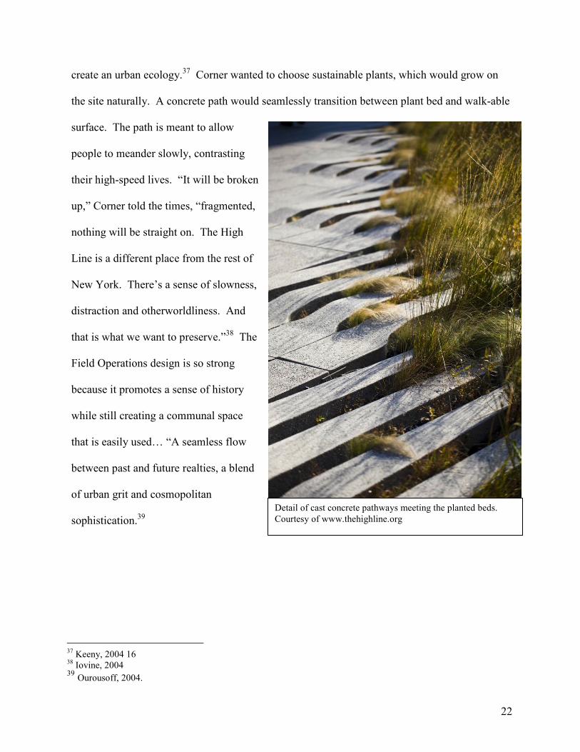
The winning design, by James Corner’s Field Operations and Diller Scofidio and Renfro, was
the second major public project won by Field Operations in New York City in the span of four
years after winning the Fresh Kills Landfill End-Use and Master Plan competition. The team
partnered with Olafur Eliasson to produce a public art installation. The proposal sought to
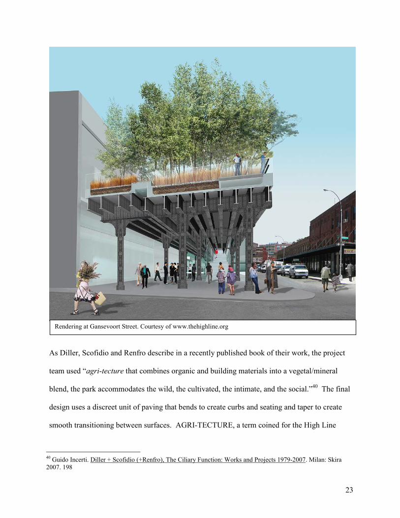
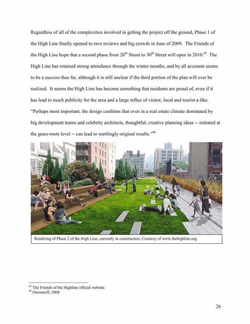
HOW URBAN SIMULATION AND THE HIGH LINE COULD COME TOGETHER
Given the nature of a large-scale project, such as the High Line, with so many people involved
and invested in its use and outcome, one may begin to see how an urban simulation could
impact the design process for the High Line. At the least complicated end, the ability to place
the project within its simulated urban setting would allow concerns to be addressed in real time,
whether it be for political or public reasons. A neighbor concerned about the view from their
window could see the simulated view post High Line development, the owner of an adjacent
gallery could plug in facade improvements to see how he or she might be able to utilize the
High Line to improve business and marketing, and a zoning official can see more clearly how
the project is impacting the surrounding area.
Furthermore, as the area is known to be rife with new developments, especially by high-profile
architects such as Jean Nouvel and Frank Gehry and many others, it is difficult to track how all
of the new buildings will continually impact each other and the park. The park currently thrives
off of the amount of light and air that it is afforded by fairly low surrounding buildings and
multiple open lots. Developers may want to occupy these sites to utilize the draw of the High
Line, but should they get too close and aggressive, they will deprive the narrow park of its light
and air. These are all issues that could be quickly understood in the context of an urban model…
especially one constantly updated with the most up-to-date, new information. To have a
common file in which even just the massing of buildings could be placed would allow designers
to not only collaborate within the project team, but also provide an opportunity for cross-project
collaborations. Such small opportunities as this could revolutionize the way in which a
neighborhood develops and allow for more synchronous design work.
30
Given the High Line’s proximity in time to 9/11, an urban simulation of the area also could
have provided safety information for the park’s design. For city approval and support, New
York had to believe that the park would be a safe place. An urban simulation could map how
emergency exiting from the elevated park might occur in the event of a disaster. Placing the
design within the simulated urban context could also highlight areas in which the park was
susceptible to security faults do to its proximity to other buildings, and sun lighting and lighting
analysis could more accurately show which part, above and below the High Line are not
adequately lit.
Most of all, the Urban Simulation, applied to a project with so many involved people, could
prove to be an invaluable marketing tool. As stated earlier, by 2008 the High Line had over
1,500 monetary supporters. In addition to these people, the park had to garner the affection of
countless government officials at all from the district to the federal level. A lot of people
needed to be able to see the project, but none of them necessarily wanted to see the same thing.
The Urban model would have provided a file, which could have been sent to all of the people
clambering to see the effects of the development without limiting the way in which they could
see it. They would not be limited to the ‘money shots’ that the design team choses to render and
highlight in a presentation – they would have had access to all the views of the project, even the
inevitably less savory ones. Having such a model would effectively expose project weaknesses,
especially if it were made visible to so many critical eyes, but is this a good thing?
The simulated High Line model could easily depict different development avenues – storefronts
facing onto the upper deck, concession etc… things that Diller, Scofidio and Renfro and Field
31
Operations might not have direct control over, but designs that would greatly impact the feel of
being a-top the elevated rail line. An Urban Simulation of the project is not necessarily adding
new information into the mix, but providing an interface that may be easier for a greater number
of people to understand. The general public, and many of the politicians involved in securing
funding for such a large-scale project most likely lack a clear understanding of construction
documents and project time-lines, but providing a realistic depiction, one that moves and adjusts
to their interests, gives them something that they can relate to. The model would allow them to
understand the project in conjunction to the surrounding neighborhood, and greater city context,
in an even clearer way than a rendering, because it gives the user control over what they are
seeing, and at what time of day/year.
It is also important to address that there are negative factors to the endless streamlining of the
design process through BIM and eventually Urban Simulation. While these programs are meant
to assist in collaboration, one must question if eliminating the need to even speak regularly on
the phone is truly a good thing in terms of the quality of design. Teams need to develop trust,
especially when team members are from different fields and offices. Designs can improve when
other design professionals challenge them, but removing the need to communicate removes a lot
of opportunity for critical discussion to take place. Architects and engineers, for example, have
long been known to have a love/hate relationship where engineers tell architects what they
would like to design is not possible, and architects are in turn forced to work and push the
engineer to come up with a system that will meet the expectations and abilities of both parties.
It is through this process that the most interesting projects are often realized. Of course direct
contact will never be completely eliminated, but in a design age where firms from all over the
32
world are thrown together on a project, it seems detrimental to design quality to encourage
minimal contact with the sole goal of eliminating project cost and maximizing profit.
Furthermore, when presentations are made, there is nothing that can replace a human explaining
a project and receive opinions. E-mail cannot read tone and cadence, perceptions that can only
be made in person, or less ideally over the phone, and perceptions that are crucial to
understanding a comment. To give a three-dimensional model to someone without any contact
could lead to great contention, and misunderstanding of intentions – feelings that may then
never clearly be conveyed if there is an initial lack of communication. Even video-conferencing
seems to lack some of the personal connection that is made through the contact of a handshake.
It is important to remember that design is a service, and that while speedy production may make
the client happy, it is also important to foster a good connection to ensure future projects and
recommendations. Being in the same room presenting a project demonstrates complete
attention to the moment and to the client. And, having a good relationship to the subcontractors
and being able to present their issues will only make the design team look more coordinated and
in control of the project that they have been contracted.
It is difficult to presume exactly how Urban Simulation might have impacted the High Line
project, or if it would have changed the design at all. An Urban Simulation might have only
served to delay the ten-year project further as more concerns were raised over design choices
and implications. It might also, however, have allowed the project to garner more supporters
earlier, gaining the necessary backing and funding to get the project underway at an earlier date.
However, it is clear that the persistent and passionate efforts of the Friends of the High Line and
33
its founders Joshua David and Robert Hammond were critical in ensuring the projects success.
They were the ones who complied networks of people, and rallied for any and all attention they
could bring to the project. This is something that a computer program will never be able to do
on its own.
High Line map and access points. Courtesy of www.thehighline.org
34
Exhibit 1: List of the Board of the High Line:
Board of the High Line
John Alschuler, Chair Philip E. Aarons, Founding Chair Joshua David, Secretary and Co-Founder Robert Hammond, President and Co-Founder Karen Ackman John Blondel James Capalino Barbaralee Diamonstein-Spielvogel Lisa Maria Falcone Philip Falcone Alexandre von Furstenberg Gary Handel Hermine Riegerl Heller Eugene Keilin, Treasurer Wendy Keys Catherine C. Marron Gifford Miller Edward Norton Mario Palumbo Steven Rubenstein Jason Stewart Darren Walker Bronson van Wyck
Ex-Officio Members
Patricia E. Harris, First Deputy Mayor Christine C. Quinn, Speaker, New York City Council Robert Lieber, Deputy Mayor for Economic Development Adrian Benepe, Parks Department Commissioner Amanda M. Burden, City Planning Commission Chair
Emeritus Members
Vishaan Chakrabarti Christopher Collins Olivia Douglas Elizabeth Gilmore Robert Greenhood Michael O'Brien, Esq. Richard Socarides Alan Stillman
35
Exhibit 2: High Line Supporters (A full list of ‘The Friends of the High Line’ can be found at www.thehighline.org)
Campaign for the High Line
It is with deep appreciation that Friends of the High Line recognizes these individuals and other funding partners for their visionary support of the Campaign for the High Line, which supports construction of the new park and an endowment for its future maintenance and operations: The Diller – von Furstenberg Family Foundation Philip A. Falcone and Lisa Maria Falcone Donald Pels and Wendy Keys Hermine and David Heller Michael and Sukey Novogratz Adam and Brittany Levinson Christy and John Mack Foundation The Pershing Square Foundation The Tiffany & Co. Foundation Philip E. Aarons and Shelley Fox Aarons John Feinblatt, The Aber D. Unger Foundation Lawrence B. Benenson John Blondel The Bobolink Foundation, Wendy Paulson James F. Capalino - Capalino+Company Sharon and Christopher Davis Barbaralee Diamonstein-Spielvogel Kristen M. Dickey Olivia Douglas and David DiDomenico The Estée Lauder Companies Inc. Janet and Howard Kagan Michael and Deborah McCarthy Edward Norton Elizabeth and Michael O’Brien Sherry Brous and Douglas Oliver Mario J. Palumbo, Jr. Paul Pariser and Erin Leider-Pariser Jonathan and Joelle Resnick Steven Rubenstein Judith Zarin and Gerald Rosenfeld Anonymous, In memory of Arland D. Williams Jr. Anonymous (1)
36
John H. Alschuler and Diana Diamond Joshua David and Stephen Hirsh Mark Diker and Deborah Colson Robert C. Greenhood Robert Hammond Gary Handel, Handel Architects Jack Resnick & Sons Katie Michel and Adam Schlesinger Pamela and Gifford Miller Donna and Alan N. Stillman A. Woodner Fund Bronson van Wyck Anonymous (1)
High Line Trust
The High Line Trust is a group of visionary supporters who join together to build, maintain, and operate a one-of-a-kind park that will enrich the future of New York City. We would like to recognize the leadership of the following members of the High Line Trust:
Co-Chairs Barry Diller and Diane von Furstenberg
High Line Trust Members Altman Foundation Chelsea Market Kristen M. Dickey Olivia Douglas and David DiDomenico The Estée Lauder Companies Inc. Johnson Family Foundation Sonia and Paul T. Jones Adam and Brittany Levinson Christy and John Mack Foundation Michael and Deborah McCarthy Donald R. Mullen, Jr. Tom Murry, President and CEO, Calvin Klein, Inc. The New York Community Trust – LuEsther T. Mertz Advised Fund Michael and Sukey Novogratz Elizabeth and Michael O’Brien Sherry Brous and Douglas Oliver Paul Pariser and Erin Leider-Pariser Wendy Paulson Joelle and Jonathan Resnick The Rockefeller Foundation Andrew Rosen
37
Trevor Stahleski and Kyle Ransford, Cardinal Investments, LLC The Tiffany & Co. Foundation Judith Zarin and Gerald Rosenfeld Anonymous, In Memory of Arland D. Williams, Jr. Anonymous
Foundation Support
The following foundation funders have generously supported Friends of the High Line since 1999, making the opening of the High Line possible: Altman Foundation Greenacre Foundation Johnson Family Foundation The J.M. Kaplan Fund The New York Community Trust – LuEsther T. Mertz Advised Fund The Rockefeller Foundation – NYC Cultural Innovation Fund The Tiffany & Co. Foundation Trust for Architectural Easements The Aber D. Unger Foundation, Inc. A G Foundation Achelis & Bodman Foundations Lily Auchincloss Foundation, Inc. The Arthur M. Blank Family Foundation The Brown Foundation, Inc. Ford Foundation The William Randolph Hearst Foundation Leon Levy Foundation Merck Family Fund National Endowment for the Arts The New York Community Trust New York State Council on the Arts
38
References: Aliaga, Daniel G. et al. “Interactive Reconfiguration of Urban Layouts,” Purdue University.
2008. Available <http://www-users.itlabs.umn.edu/classes/Fall-2009/csci8980-compgnd/reading_list/urban%20design/aliaga_cga08.pdf> 12/16/2009
Aliaga, Daniel G. et a. “Interactive Example-Based Urban Layout Synthesis.” Purdue
University, 2008. Available < http://portal.acm.org/citation.cfm?id=1457515.1409113> Cardwell, Diane. “For High Line Visitors, Park Is a Railway Out of Manhattan.” The New
York Times. July 21, 2009. Clines, Francis X. “What’s That Weird Purple Thing?” The New York Times. August 17, 2009. Chen, Guoning et al. “Interactive Procedural Street Modeling.” 2008. Available
<http://people.oregonstate.edu/~cheng/street_sig08/street_project.htm> 12/16/2009 Cramer, James and Simpson, Scott. The Next Architect. Norcross GA: Greenway
Communications. 2006 David, Joshua. Reclaiming the High Line. New York: Pentagram. 2002. Dunlap, David W. “In This Pool, a Single Lap Is a Workout.” The New York Times. Published
June 1, 2003 Finn, Robin. “Two Friends, and the Dream of a Lofty Park Realized.” The New York Times.
Published July 11, 2008 Friends of the High Line official website. Available <www.thehighline.org> 12/15/2009 Hu, Winnie. “City Unveils Plans to Turn Old Rail Line Into a Park.” The New York Times.
Sept. 25, 2003. Incerti, Guido. Diller + Scofidio (+Renfro), The Ciliary Function: Works and Projects 1979-
2007. Milan: Skira 2007. Iovine, Julie V. “Architecture; Elevated Visions.” The New York Times. Published July 11,
2004 Keeny, Gavin, “The High Line and he Return of the Irreal.” Competitions. Winter 2004/2005. MacLeod, Douglas. “Roll up the BIM to Wim.” The Canadian Architect. V. 53, no 8. August
2008. McIntire, Mike. “Move to Reclaim Rail Line Receives Bipartisan Push.” The New York Times.
July 25, 2003. Muller, Pascal. “Procedural Modeling of Buildings.” 2006. Available
Ottchen ,Cynthia. “The future of Information Modeling and the End of Theory: Less is More is
Different.” Architectural Design, v. 79. March/April 2009. Ourousoff, Nicolai. “An Appraisal; Gardens in the Air Where the Rail Once Ran.” The New
York Times. Aug 12, 2004 Ouroussoff, Nicolai. “On High, a Fresh Outlook.” The New York Times. June 10, 2009. Parish, Yoav I. H, and Pascal Muller. “Procedural Modeling of Cities.” Published though the
ETH Zurich, 2001. Available < graphics.ethz.ch/Downloads/Publications/Papers/2001/p_Par01.pdf> 12/16/2009
Parnell, Steve. “Building Information Modeling.” Achit J. No 4. July 23, 2009. Poegrebin, Robin “First Phase of High Line Is Ready for Strolling.” The New York Times.
Published June 8, 2009 Poegrebin, Robin. “Philanthropist With a Sense of Timing Raises Her Profile.” The New York
Times. June 30, 2009. Pollalis, Spiro et al. “Exchange Square London: Information Technology for Collaboration.” A
Case Study completed at Harvard’s Graduate School of Design. 2005. Robertson, Campbell. “Boldface Names.” The New York Times. July 20, 2004. Weber, Basil et al. “Interactive Geometric Simulation of 4D Cities.” Eurographics 2009. Vol.
28, No. 2. Available <http://www.procedural.com/publications/2008_EG_Urban_Simulation/2008.EG.Weber.UrbanSimulation.Paper.pdf> 12/16/2009