U.S. Army Research, Development and Engineering Command US ARMY CERDEC Dismounted Solder Navigation – Update 2012 Precision Indoor Personnel Location and Tracking Annual International Technology Workshop DISTRIBUTION STATEMENT A. Approved for public release; distribution is unlimited. CP&I - Delivering Innovation
Transcript
U.S. Army Research, Development and
Engineering Command
US ARMY CERDEC Dismounted Solder Navigation – Update
2012 Precision Indoor Personnel Location and Tracking Annual International Technology Workshop
DISTRIBUTION STATEMENT A. Approved for public release; distribution is unlimited.
CP&I - Delivering Innovation
Critical Gaps – Technologies & Objectives
FY11 FY12 FY13
MEMS INERTIAL SENSOR TECH
Sensor Improvements, Error Compensation
RF RANGING
Passive Ranging, Signals of Opportunity, UWB
TIME & FREQUENCY
Chip Scale Atomic Clock, Common Time Module
INTEGRATED NAVIGATION
Ultra Tight, Decentralized Nav
IMPROVED GPS RECEIVER
Multipath Mitigation, Net Assisted GPS,
Software Receiver, M-Code Enhancements
Technical Objective
Find Solutions Suitable for
Soldier Navigation in GPS
Challenged Environments.
Critical Gaps
Providing Position,
Velocity & Time
- Too Heavy
- Too Large
- Too Costly
-Too Much Power
- Not Robust
(Urban/Indoor)
Basic Strategy Chart
VISION BASED TECH
SLAM, Optical Flow, Feature Extraction
2
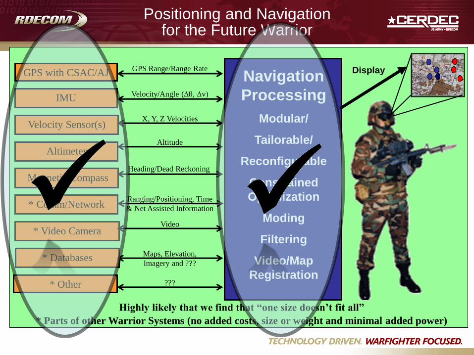
Positioning and Navigation for the Future Warrior
GPS with CSAC/AJ
* Comm/Network
Altitude
Magnetic Compass
IMU
Video
Velocity/Angle (Dq, Dv)
* Video Camera
Velocity Sensor(s)
Altimeter
Heading/Dead Reckoning
Ranging/Positioning, Time
& Net Assisted Information
Navigation
Processing
Modular/
Tailorable/
Reconfigurable
Constrained
Optimization
Moding
Filtering
Video/Map
Registration
X, Y, Z Velocities
GPS Range/Range Rate Display
???
Maps, Elevation,
Imagery and ??? * Databases
Highly likely that we find that “one size doesn’t fit all”
* Parts of other Warrior Systems (no added costs, size or weight and minimal added power)
* Other
RF Adaptive Technologies Integrated with Communications and Location (RADICAL)
Purpose:
Develop and demonstrate software that identifies available
spectrum dynamically (RF-aware) for tactical
communications and for position location in GPS-degraded
environments
Products:
• Software module that enables spectrum policy
management for Dynamic Spectrum Access (DSA)
enabled radios (e.g. PRC-148/152)
• Architecture to integrate and enhance DARPA Disruption
Tolerant Networking (DTN) for future use in Army tactical
networks such as WIN-T
• Software for position locating based on Net Assisted GPS
and signal timing techniques
Payoff:
• Reliable message delivery in disruptive communications
environment
• Provide position locating in GPS degraded environments
Technologies:
• RF Ranging
• NetAssisted GPS
Platforms:
• JTRS Radios
• Android Smartphone
• WIN-T
Radio Frequency (RF) Ranging
Purpose of the Project:
Increase ranging capability that serves as an aiding
source for dismounted Soldiers to navigate in the GPS
impaired environment
Product:
Software module that enables Radio platforms to perform
RF ranging
Payoff for the Army: • Capability to aid tracking Soldiers and platforms for
Future Force operations and training • Operational benefits for the Future Force, contributes to:
enhanced communication, increased maneuver, situational awareness, reduction of friendly fires, and increased lethality.
Technologies:
• RF Active Ranging: Capturing the communication channel
to send ranging messages.
• RF Passive Ranging: Extracting time from the header of
existing communication packet exchanges.
• Hybrid Ranging: Combining Active and Passive Ranging
Platforms:
• JTRS Radios
• Android Smartphone
Performers: ITT and ENSCO
Δt
ΔX/2
Purpose:
Deliver a soldier navigation solution that
uses team-wide information and
collaborative distributed computing to
provide a position accuracy of 1m in GPS
denied environments.
Objectives and Benefits:
• High accuracy and robust navigation for
dismounted warfighters
• Team-wide solution leveraging
collaborative, distributed computing
• Scales with resources available,
including opportunistic use of soldier-
based computing and communications
resources
Performers: TRX, Mercury
Distributed Navigation
Network Assisted Navigation
• Program Objective: Utilize existing networks to distribute existing data to improve