U.S. Route 206 over Conrail (CSX) U.S. Route 206: M.P. 62.6 – M.P. 63.06 Township of Montgomery Somerset County New Jersey Prepared for NJDOT - BUREAU OF PROJECT SCOPE DEVELOPMENT July 1999 (Revised)
Transcript
U.S. Route 206 over Conrail (CSX)
U.S. Route 206: M.P. 62.6 – M.P. 63.06
Township of Montgomery Somerset County
New Jersey
Prepared for NJDOT - BUREAU OF PROJECT SCOPE DEVELOPMENT
July 1999 (Revised)
New Jersey Department of Transportation
Route 206 Bridge over Conrail Page i Concept Development Report July 1999 (Revised)
TABLE OF CONTENTS
Table of Contents.................................................................................................................................i
List of Figures....................................................................................................................................iv
List of Tables.....................................................................................................................................vi
Appendices....................................................................................................................................... vii
Executive Summary.......................................................................................................................... viii
I. INTRODUCTION .................................................................................................................. 1 A. General Information............................................................................................................. 1
1. Background......................................................................................................................... 1 2. Problem Statement .............................................................................................................. 1 3. Project Limits...................................................................................................................... 1 4. Project Location Map.......................................................................................................... 1 5. Data Reviewed.................................................................................................................... 1 6. Concurrent Projects............................................................................................................. 3 7. Original and Successor Projects........................................................................................... 4
B. Coordination Input............................................................................................................... 4 1. In House Coordination......................................................................................................... 4
a. Core Group Members ..................................................................................................... 4 b. Meetings by date ............................................................................................................ 5
2. Local Outreach Coordination............................................................................................... 5 3. Inter Agency Coordination................................................................................................... 6
a. Environmental Agency Coordination................................................................................. 6 1) NJDEP – Land Use Regulation Program..................................................................... 6 2) NJDEP - Historic Preservation Office Charles Scott................................................... 6
b. Transportation Authority Coordination............................................................................. 6 4. Summary of Issues & Concerns ........................................................................................... 8
II. PLANNING INPUT ............................................................................................................... 8 A. SIP/TIP conformity.................................................................................................................. 8 B. MIS/CMS analysis .................................................................................................................. 8 C. Regional vs. Local Significance................................................................................................. 8 D. State Development and Redevelopment Plan (SDRP)............................................................... 8
New Jersey Department of Transportation
Route 206 Bridge over Conrail Page ii Concept Development Report July 1999 (Revised)
E. Planned Developments.............................................................................................................. 9 F. Corridor Compatibility.............................................................................................................. 9 G. MPO Comments ..................................................................................................................... 9 H. TMA Input.............................................................................................................................. 9 I. NJ Transit Input........................................................................................................................ 9 J. Project Category ....................................................................................................................... 9
1. Capital Investment Strategy.................................................................................................. 9 2. National Highway System.................................................................................................... 9 3. NJDOT Construction Cost Estimate .................................................................................... 9
K. Desired Typical Section.......................................................................................................... 10 L. Needs Statement .................................................................................................................... 10
III. EXISTING CONDITIONS ANALYSIS............................................................................... 10 A. Highway Classification............................................................................................................ 10 B. Characteristics of the Roadways and Surrounding Area ........................................................... 10 C. Environmental Screening Report & Map ................................................................................. 11 D. Existing Roadway Inventory & Deficiencies............................................................................. 11
1. Passing & Stopping Sight Distance..................................................................................... 11 a. Passing Sight Distance.................................................................................................... 12 b. Stopping Sight Distance ................................................................................................. 12
a. Surface Type ................................................................................................................ 15 b. Cross Slope .................................................................................................................. 15 c. Lane Widths .................................................................................................................. 16 d. Shoulder Widths............................................................................................................ 16 e. Roadside or Border ....................................................................................................... 16 f. Curbs ............................................................................................................................ 17 g. Sidewalks...................................................................................................................... 17 h. Medians ........................................................................................................................ 17 i. Bridges (Lateral and Vertical Clearances)........................................................................ 17
F. Traffic Data............................................................................................................................ 22 G. Accident Summary and Analysis ............................................................................................. 23
IV. SUMMARY OF EXISTING DEFICIENCIES...................................................................... 24
V. PROJECT NEED .................................................................................................................. 24 A. Restatement of Problem.......................................................................................................... 24 B. Project Goals & Objectives .................................................................................................... 25
VI. CONCEPTS.......................................................................................................................... 25 A. Design Controls...................................................................................................................... 25
1. Design Standards................................................................................................................ 25 a.Roadway and Appurtenances.......................................................................................... 25 b.Bridges and Structures.................................................................................................... 25
B. Concept “A”.......................................................................................................................... 27 C. Concept “B” .......................................................................................................................... 27 D. Concept “C”.......................................................................................................................... 27
VII. RECOMMENDATIONS...................................................................................................... 28
VIII. POTENTIAL INTERIM ACTION ITEMS ........................................................................... 28
New Jersey Department of Transportation
Route 206 Bridge over Conrail Page iv Concept Development Report July 1999 (Revised)
IX. NEXT STEPS........................................................................................................................ 28
Devise a statement as to how the conceptual solution would advance the DOT’s objectives.
X _____ _____
Environmental Screening Report. X _____ _____
Evaluation Identification of Other Features X _____ _____
Existing and projected LOS and traffic queues analyses. _____ X _____
Existing information, including but not limited to the following: ROW, widths, number of lanes per approach/ramp/mainline and corresponding widths, shoulder widths, median widths, and border widths for all facilities.
X
_____
_____
Geotechnical Investigation _____ _____ X
Identification of Conceptual Solutions X _____ _____
Location Map. X _____ _____
Location overview and deficiency evaluation summary X _____ _____
Photo (digital format) and video log. X _____ _____
Planning Information X _____ _____
Recommendation and Justification for advancing the scoping effort. X _____ _____
Summary of Coordination with local officials and in-house bureaus X _____ _____
Traffic flow diagrams. X _____ _____
Tax Maps X _____ _____
Utility Summary. X _____ _____
Verification of the problem and restatement of the need. X _____ _____
Data Collection Summary Report that will provide most of the information needed in the Scope Development Document Sections I. and II.
X
_____
_____
A scope development journal will be kept chronologically from the beginning of the Data Collection process to document all major design considerations, assumptions, issues and directives encountered during concept development and feasibility analysis. Also included in the
X
_____
_____
New Jersey Department of Transportation
Route 206 Bridge over Conrail Page viii Concept Development Report July 1999 (Revised)
journal will be notes concerning any contacts made with individuals or agencies during scope development.
New Jersey Department of Transportation
Route 206 Bridge over Conrail Page ix Concept Development Report July 1999 (Revised)
APPENDICES
A. Problem Statement B. Traffic Volumes C. Shotgun Letter Responses/Memos of Meetings D. Bridge Inspection Reports/Data Sheets/SIA E. Accident Analysis / Collision Diagrams F. Environmental Screening Report
New Jersey Department of Transportation
Route 206 Bridge over Conrail Page x Concept Development Report July 1999 (Revised)
EXECUTIVE SUMMARY
This summary was prepared by Greenman-Pedersen, Inc. for the New Jersey Department of Transportation’s Bureau of Project Scope Development, and provides a concise description of the problem location, with conclusions and recommendations, as of July, 1999. Problem Location: Route 206, from milepost 62.6 to 63.06 in Montgomery Township, New Jersey. The project also involves the intersection of Route 206 with C.R. 601. Primary Issues Identified: The bridge carrying Route 206 over Conrail (Structure No. 1810-156) in Montgomery Township, Somerset County is in overall critical condition due to its low inventory ratings. The deck is in poor condition exhibiting leakage, fine random cracking, and exposed rebar. The superstructure is in poor condition with exposed structural steel due to deterioration of the concrete encasements of both through girders. The concrete encasement of the floor beams has spalled off exposing severely rusted bottom flanges with section loss of up to 30%. The substructure is in poor condition with severe scaling and large spalls at several locations. The approach roadway alignment for the bridge is substandard both horizontally and vertically. There is a significant speed reduction required at the north approach to the bridge. The vertical alignment and tight horizontal curvature provide poor sight distance for vehicles crossing the bridge. The problem statement recommends replacement of the structure with a bridge that meets current NJDOT standards in both structural capacity and geometry. The replacement of this bridge to meet current standards would require realignment of Route 206 to improve this substandard geometry. Any realignment of this section of roadway would necessitate the acquisition of right of way, and the new structure would have to be constructed on a skew over the Conrail (CSX) tracks. The NJDOT is currently studying a bypass for Route 206. The Route 206 Bypass conceptual alignment provides an interchange at Bellemead-Griggstown Road in Montgomery Township and continues on a new alignment into Hillsborough Township where it ties back into Route 206 near Old Somerville Road. In March 1999, the Federal Highway Administration (FHWA) informed the NJDOT that the Route 206 Bypass project could be advanced without the need for a Supplemental Environmental Impact Statement. This project affects the degree to which the existing Route 206 bridge over Conrail needs to be realigned. As of March 1999, the Value Engineering Unit suggested that the Bypass eliminates the need for the existing Route 206 bridge over the Conrail tracks. However, Montgomery Township supports the replacement of this structure, as it provides an important transportation link for the community.
New Jersey Department of Transportation
Route 206 Bridge over Conrail Page xi Concept Development Report July 1999 (Revised)
Because the Route 206 through traffic will be accommodated on the Bypass roadway, the replacement structure would be used for local traffic only. Recommendations: Although the Value Engineering Unit suggested that the existing bridge over the Conrail tracks would no longer be necessary with the construction of the Bypass, the Montgomery Township officials support the replacement of the structure. Schemes will be development during Feasibility Assessment to provide a replacement structure on alternative alignments. Suggested schemes to be developed during Feasibility Assessment are included in the Concept Development Report. The recommended concept to advance to Feasibility Assessment includes:
• Maintain the existing bridge over the CSX tracks until the new bridge is in place to limit the spalling and extend the life of the structure.
• Replacement of the bridge over the CSX line. • Improve the geometry of the approach roadways • Provide full shoulders adjacent to the travel lanes • Analyze alternative concepts for the replacement structure including the following
alternatives: − Construct a new structure paralleling the existing, but shifted to the south. Existing
206 would meet C.R. 601 at a “T” intersection. − Construct a new structure on a skew angle over the railroad. This alternative would
increase the cost, but would improve the geometry significantly.
New Jersey Department of Transportation
Route 206 Bridge over Conrail Page 1 Concept Development Report July 1999 (Revised)
I. Introduction
A. General Information
1. Background
This report documents the results of the Concept Development Phase for the replacement of the Route 206 bridge over Conrail in Montgomery Township, Somerset County. The existing conditions for the bridge and for Route 206 in the project area are described within this report. Structural deficiencies, substandard features and undesirable conditions are identified. Existing traffic and accident information, preliminary environmental constraints, and identification of conceptual solutions are also included.
2. Problem Statement
The U.S. Route 206 Bridge over Conrail (Structure No. 1810-156) is in poor condition due to the condition of its superstructure. The reinforced concrete slab superstructure exhibits severely disintegrated concrete, severe scaling and spalling, and exposed rusting reinforcing bars along with section loss. There is also severe rusting to the through girders and bearings. The bridge has a sufficiency rating of 9, and is classified as structurally deficient. The bridge is also classified as functionally obsolete due to its inadequate deck geometry. The problem statement recommends that the structure be replaced with a bridge that meets current NJDOT standards. The transportation problem statement for the Route 206 Bridge over Conrail from the NJDOT is included within this report as Appendix A.
3. Project Limits
The project area extends approximately from milepost 62.6 (km P. 100.74) to milepost 63.06 (km P. 101.48) on Route 206. According to the 1998 NJDOT Straight Line Diagrams, the bridge is located at milepost 62.77. All proposed improvements are within Montgomery Township, Somerset County.
4. Project Location Map
A project location map is included in this report as Figure 1.
5. Data Reviewed
During the data collection phase of this project, specific sources were consulted to obtain information on existing conditions in the study area.
New Jersey Department of Transportation
Route 206 Bridge over Conrail Page 2 Concept Development Report July 1999 (Revised)
Figure 1
Location Map – U.S. Route 206 Bridge 0ver Conrail
New Jersey Department of Transportation
Route 206 Bridge over Conrail Page 3 Concept Development Report July 1999 (Revised)
This information was evaluated to determine areas of non-conformance with current design standards and will form the base data for use during the development of improvement alternatives. For this project, the following information was available for review:
Table 1 – Data Reviewed
DATA SOURCE DATE Route 206 over Conrail Problem Statement NJDOT Sept.,1994 Aerial Photography of Project Area Keystone Accident Reports NJDOT 1995-1997 As-Built Bridge Plans for Structure No. 1810-156 NJDOT 1918 Route 206 Bypass Concept Plans Sections 14A & 15A 3/1999 R.O.W. General Property Key Map NJDOT 1926 As-Built Plans-Route 206 Section 15G, 14C & 13C NJDOT Structural Inventory & Appraisal Data NJDOT July 1997 Cycle 8 Bridge Inspection Report for Str. No. 1810-156 NJDOT April 1997 Tax Maps Montgomery 1997 Zoning Map Montgomery Feb. 1995 Peak Hour and ADT Traffic Volumes (1998/2017/2025) NJDOT 1999 Accident Analysis & Summary NJDOT March 1999 Environmental Screening NJDOT April 1999
In addition to this specific information, a field visit was conducted to ascertain and document existing conditions. During the field visit, digital photographs, sketches, and field dimensions were recorded for use during the scheme development phase of the project. A photograph log was produced and submitted to the NJDOT Bureau of Scope Development (BPSD).
6. Concurrent Projects
The New Jersey Department of Transportation is currently studying a bypass for Route 206. The Route 206 Hillsborough Bypass conceptual alignment provides an interchange at Belle Mead-Griggstown Road in Montgomery Township and continues on a new alignment into Hillsborough Township where it ties back into Route 206 near the bifurcation of Old Somerville Road, just north of Tributary B of Royce Brook. (See Figure 2)
In March 1999, the FHWA informed the NJDOT that the Route 206 Bypass project could be advanced without the need for a Supplemental Environmental Impact Statement. Before that time, the Department was unsure when the Bypass project would be constructed. The Bypass project certainly affects the degree to which the existing Route 206 bridge over Conrail needs to be realigned.
Somerset County was contacted to determine if they had any concurrent projects that may impact this project. The county has several project listed in the Somerset County
New Jersey Department of Transportation
Route 206 Bridge over Conrail Page 4 Concept Development Report July 1999 (Revised)
Capital Improvement Plan that are scheduled for construction with the next six years. Projects that are may influence the Route 206/Conrail bridge replacement project include the intersection of C.R. 601 (Belle Mead/Blawenburg Road) with Reading Boulevard. This intersection is approximately 750 feet south of the intersection of Route 601 with Route 206. According to Sargent Joseph Yanicak of the Montgomery Township Police Department, this intersection has the highest accident rate in the township.
7. Original and Successor Projects The original project under which Route 206 and the bridge were constructed is as follows:
• New Jersey State Highway Department, Route 16, Section 9 (1920).
The successor projects within the project limits for which documentation has been located are as follows:
• New Jersey Department of Transportation, Route 206-Section 15G, 14C & 13C-
Widening, Paving and Drainage at Various Locations. This project provided intermittent resurfacing along the Route 206 corridor. No resurfacing was provided within the immediate location of the Structure No. 1810-156.
Field observation also indicates that resurfacing, overlay and widening projects must have occurred since the original project. No documentation of these projects has been recovered. The roadway south of the bridge was recently resurfaced and widened under a developer agreement project (Pike Run).
B. Coordination Input
1. In House Coordination
a. Core Group Members - Shotgun letters were sent out to the various NJDOT bureaus for input from each of the disciplines. Shotgun letter responses and memos of meetings held during Concept Development are included within this report within Appendix C. The Core Group Leaders for this project include the following people:
Table 2 – Core Group Members John Mansfield Geotechnical Engineering Henri Renelli Landscape and Urban Design Michael Russo Geometrics Wladislau Szalaj Hydrology/Hydraulics
New Jersey Department of Transportation
Route 206 Bridge over Conrail Page 5 Concept Development Report July 1999 (Revised)
Eric Kraehenbuehl Surveying Services
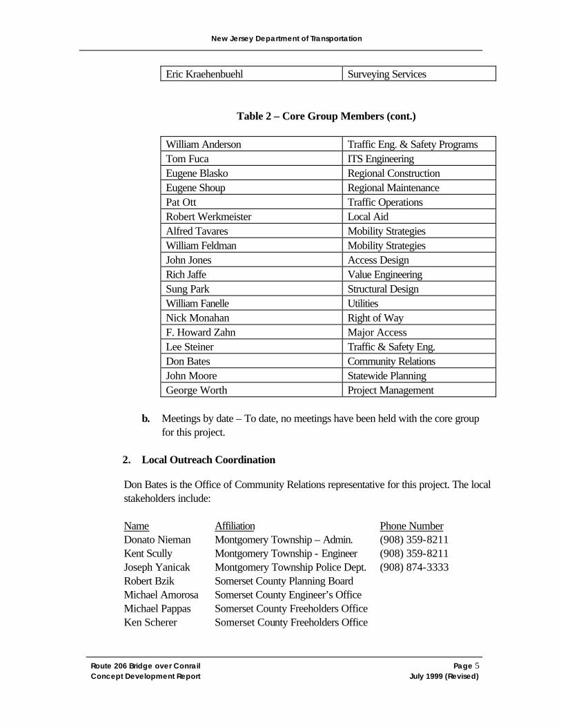
Table 2 – Core Group Members (cont.)
William Anderson Traffic Eng. & Safety Programs Tom Fuca ITS Engineering Eugene Blasko Regional Construction Eugene Shoup Regional Maintenance Pat Ott Traffic Operations Robert Werkmeister Local Aid Alfred Tavares Mobility Strategies William Feldman Mobility Strategies John Jones Access Design Rich Jaffe Value Engineering Sung Park Structural Design William Fanelle Utilities Nick Monahan Right of Way F. Howard Zahn Major Access Lee Steiner Traffic & Safety Eng. Don Bates Community Relations John Moore Statewide Planning George Worth Project Management
b. Meetings by date – To date, no meetings have been held with the core group
for this project.
2. Local Outreach Coordination
Don Bates is the Office of Community Relations representative for this project. The local stakeholders include:
Name Affiliation Phone Number Donato Nieman Montgomery Township – Admin. (908) 359-8211 Kent Scully Montgomery Township - Engineer (908) 359-8211 Joseph Yanicak Montgomery Township Police Dept. (908) 874-3333 Robert Bzik Somerset County Planning Board
Michael Amorosa Somerset County Engineer’s Office
Michael Pappas Somerset County Freeholders Office Ken Scherer Somerset County Freeholders Office
New Jersey Department of Transportation
Route 206 Bridge over Conrail Page 6 Concept Development Report July 1999 (Revised)
A meeting was held with the Montgomery Township officials on July 26, 1999 at the Montgomery Township office. It was noted that the Hillsborough Route 206 Bypass project is moving forward. A public information center is scheduled for this project on Thursday, July 29, 1999. This Route 206 bypass will carry a significant percentage of the current Route 206 traffic. Volume projections for the existing Route 206 section over the Conrail bridge show volumes at about 20% of their current volume. Because of the reduced volumes, the NJDOT Value Engineering unit suggested that the existing bridge over Conrail should be maintained until the Bypass is completed. At that time, VE suggested that the existing bridge should be removed and not replaced. The connections between the Bypass and existing Route 206 could be made by nearby roadways, all of which are located in adjacent Hillsborough Township.
The Montgomery officials were opposed to the concept of closing the bridge in this location for several reasons. These include: inconvenience to residents; the post office is located in the northerly section of Montgomery, which would be separated from the rest of the Township; there are several businesses located north of the bridge; emergency response time would be unacceptable to this area. County Route 601 just south of its intersection with Route 206 has very sharp curvature and a significant accident history. It is important to maintain the link from the Township to this area for maximize response time.
It was discussed that several alternatives will be developed and discussed with the Township at future meetings. 3. Inter Agency Coordination
The following agencies and their contact person are included in the following sections. Any correspondence with these agencies is addressed in later sections of this report.
a. Environmental Agency Coordination 1) NJDEP – Land Use Regulation Program Chris Jones 2) NJDEP - Historic Preservation Office Charles Scott
b. Transportation Authority Coordination 1) Federal Highway Administration Robin Schroeder 2) North Jersey Transportation Planning Authority Ted Matley 3) New Jersey Transit (Rail) Jack Kanarek 4) CSX(Conrail takeover) Carl Roe 5) Conrail F.X. Giacoma
New Jersey Department of Transportation
Route 206 Bridge over Conrail Page 7 Concept Development Report July 1999 (Revised)
FIGURE 2 Route 206 Bypass project
New Jersey Department of Transportation
Route 206 Bridge over Conrail Page 8 Concept Development Report July 1999 (Revised)
4. Summary of Issues & Concerns
In summary, there appear to be few major concerns at this time that would preclude proceeding with this project, and no signs of fatal flaws. The Route 206 Bypass project is expected to proceed to construction in 2003. The timing of that project and the shift of traffic volumes from the existing Route 206 alignment to the Bypass alignment may impact this project. The substandard horizontal and vertical geometry approaching the structure from both the north and the south must be improved in any alternative developed.
Issues that may affect the project include: the potential historic foundations north of the Conrail bridge; the potential for the West Trenton Branch to be reactivated; the possibility of a park and ride facility near the railroad tracks; and the recent development of several large tracts of land in the vicinity of the bridge.
II. Planning Input
A. SIP/TIP conformity B. MIS/CMS analysis
A request for waiver will be prepared for this project because it is a bridge replacement project, additional lanes are not expected, and the capacity of the roadway is not expected to increase.
C. Regional vs. Local Significance
D. State Development and Redevelopment Plan (SDRP)
A consistency analysis was performed for this project by the Bureau of Statewide Planning. This analysis states that the replacement of the Route 206 bridge over Conrail seems necessary from a both safety and system preservation standpoint. This standpoint is consistent with the State Plan according to the following policies:
1. Statewide Public Investment Priorities Policy 1 states that highest priority be given to infrastructure project that mitigate life-threatening situations and emergent threats of public health and safety, regardless of location.
2. Statewide Public Investment Priorities Policy 2 states that maintenance and repair of infrastructure should be given priority over all other infrastructure expenditures except those that protect public health and safety.
3. Statewide Transportation Policy 7 states that preservation and maintenance of the existing transportation network is the highest transportation priority.
New Jersey Department of Transportation
Route 206 Bridge over Conrail Page 9 Concept Development Report July 1999 (Revised)
E. Planned Developments F. Corridor Compatibility
G. MPO Comments
The North Jersey Transportation Planning Authority requested a review of the NJTPA’s Operational Congestion Management Systems: SOV Capacity Increase Studies procedures to determine if the project meets the three criteria, which trigger the need for a CMS.
H. TMA Input
I. NJ Transit Input
NJ Transit is currently studying the feasibility of restoring commuter passenger rail service on Conrail’s (CSX’s) existing freight-only Trenton Line between West Trenton and the Raritan Valley Line. One of the proposed station stops would be at Belle Mead, which is proximate to this project. If passenger service is restored, the Trenton Line right of way and the Belle Mead station location will undergo construction of new track, platforms, parking and restoration of the existing station building. The new structure over the Trenton Line should maintain, at a minimum, the lateral clearances of the existing bridge.
NJ Transit does not operate any bus service on Route 206 in this area.
J. Project Category
The project is categorized for each of the following: 1. Capital Investment Strategy
This project is categorized as a Bridge Rehabilitation and Replacement Project based on the Capital Investment Strategy.
2. National Highway System
According to the New Jersey Department of Transportation’s “Procedures Manual” - Section 4.1.1, this project is categorized as a National Highway System New Construction or Reconstruction (NHS-NEW / RECON).
3. NJDOT Construction Cost Estimate
New Jersey Department of Transportation
Route 206 Bridge over Conrail Page 10 Concept Development Report July 1999 (Revised)
The Route 206 over Conrail bridge replacement is classified as a Reconstruction, Widening and Dualization project according to the New Jersey Department of Transportation’s Construction Cost Estimates.
K. Desired Typical Section
Route 206 is one lane in each direction over the structure and north of the structure. Because the Bypass will be carrying a large percentage of the volume that currently uses the roadway, a typical section with one northbound lane, one southbound lane, and shoulders is expected. Additional lanes will not be required due to the reduced future volumes.
L. Needs Statement
Structure number 1810-156 is in poor condition due to excessive deterioration of the deck, superstructure and substructure. Because of this deterioration, the bridge is classified as structurally deficient due to its substandard load capacity. The approach roadway alignment for the bridge is classified as “intolerable due to the significant speed reduction required at the north approach to the bridge.” The vertical alignment and tight horizontal curves at this approach provide poor sight distance for vehicles crossing the bridge.
III. Existing Conditions Analysis
A. Highway Classification
U.S. Route 206, which runs north to south, is an undivided, rural, principal arterial within the project limits. It is included in the National Highway System (NHS) system. The NHS system is an interconnected system of Principal Arterial routes that serve major population centers, international border crossings, ports, airports, public transportation facilities and other intermodal transportation facilities and serve interstate and interregional travel. This system replaced the Federal Aid Primary (FAP) system. The NHS justification provided within Section 1.5 of the NJDOT Procedures Manual states that Route 206 is a principal arterial, serves interregional travel, provides rural/urban connectivity, is a STRAHNET major connector (from NJ 68 to Co. 545), and serves a recreational area.
B. Characteristics of the Roadways and Surrounding Area
U.S. Route 206 at the Conrail Bridge in Montgomery Township is a two-lane Federal highway that serves both northbound and southbound through traffic with access to the adjacent commercial and residential properties. The project is located near the northerly limit of Montgomery Township, near the border of Hillsborough Township. The area surrounding the project includes suburban subdivisions, office complexes and shopping centers to the north, and large masses of undeveloped land, interspersed by sparse residential, commercial
New Jersey Department of Transportation
Route 206 Bridge over Conrail Page 11 Concept Development Report July 1999 (Revised)
and industrial development, wooded tracts, rural towns and villages, and farmland to the south. C. Environmental Screening Report & Map
The Policy and Special Services Section of the New Jersey Department of Transportation’s Bureau of Environmental Services prepared an Environmental Screening Report dated April 20, 1999 of the project area which identified any constraints that would prevent the advancement of this project. The items investigated were Cultural Resources, Ecological Resources, Hazardous Waste, and 4(f) properties. The results of the investigation suggest that there appear to be no environmentally sensitive issues that would have a negative impact on the advancement of the project. However, some constraints may warrant consideration during design in order to minimize environmental impacts. Although no large wetlands or floodplains exist within the study area, there are manmade ditches associated with the railroad and roadways. If these are affected a general wetland permit may be required. There were no properties within the study area listed with the NJ or National Registers of Historic Places; however, the SHPO feels that the Harlingen Reformed Cemetery is eligible for a listing in the National Register. Furthermore, the Reverend Labagh House is eligible for listing in the National Registry. Finally, concerning hazardous waste, there are no contaminated sites within the study area. A copy of the Environmental Screening Report can be found in Appendix F.
D. Existing Roadway Inventory & Deficiencies
1. Passing & Stopping Sight Distance
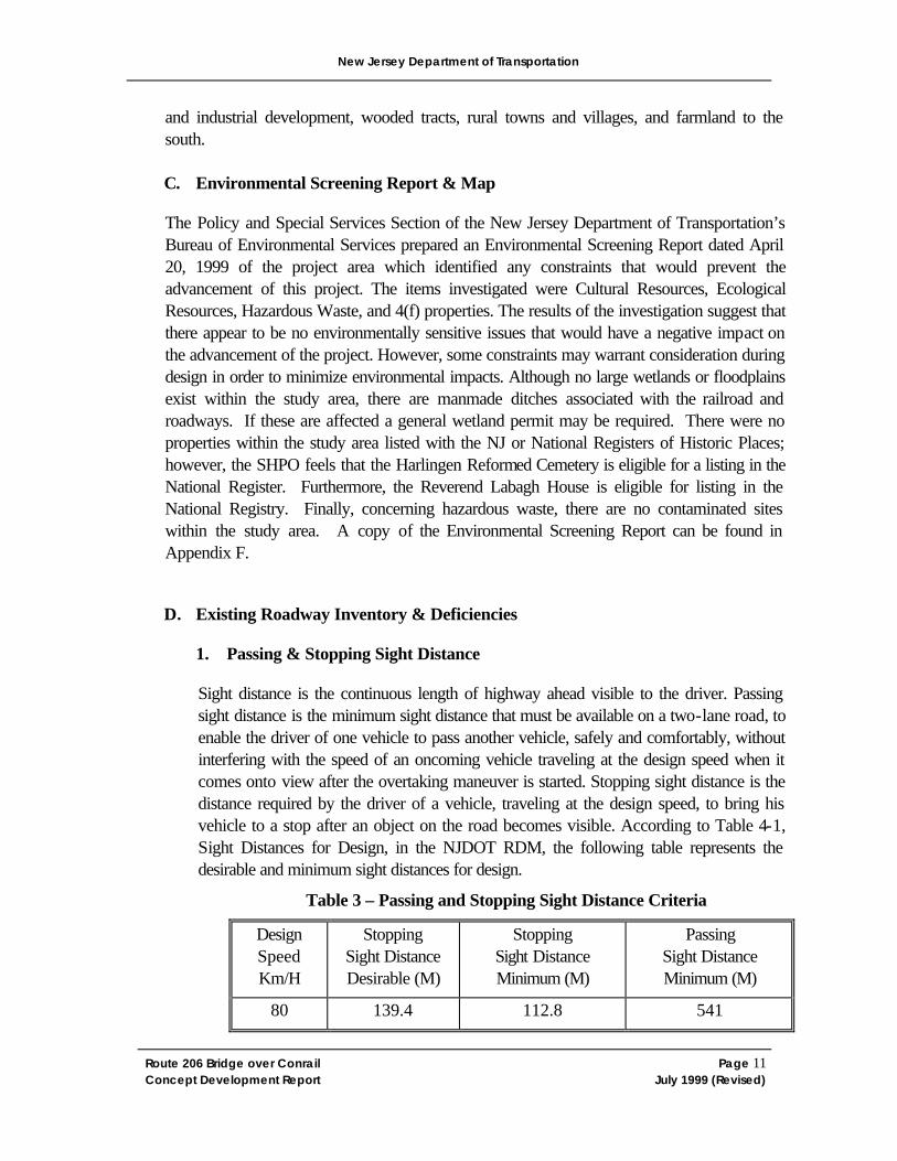
Sight distance is the continuous length of highway ahead visible to the driver. Passing sight distance is the minimum sight distance that must be available on a two-lane road, to enable the driver of one vehicle to pass another vehicle, safely and comfortably, without interfering with the speed of an oncoming vehicle traveling at the design speed when it comes onto view after the overtaking maneuver is started. Stopping sight distance is the distance required by the driver of a vehicle, traveling at the design speed, to bring his vehicle to a stop after an object on the road becomes visible. According to Table 4-1, Sight Distances for Design, in the NJDOT RDM, the following table represents the desirable and minimum sight distances for design.
Table 3 – Passing and Stopping Sight Distance Criteria
Design Speed Km/H
Stopping Sight Distance Desirable (M)
Stopping Sight Distance Minimum (M)
Passing Sight Distance Minimum (M)
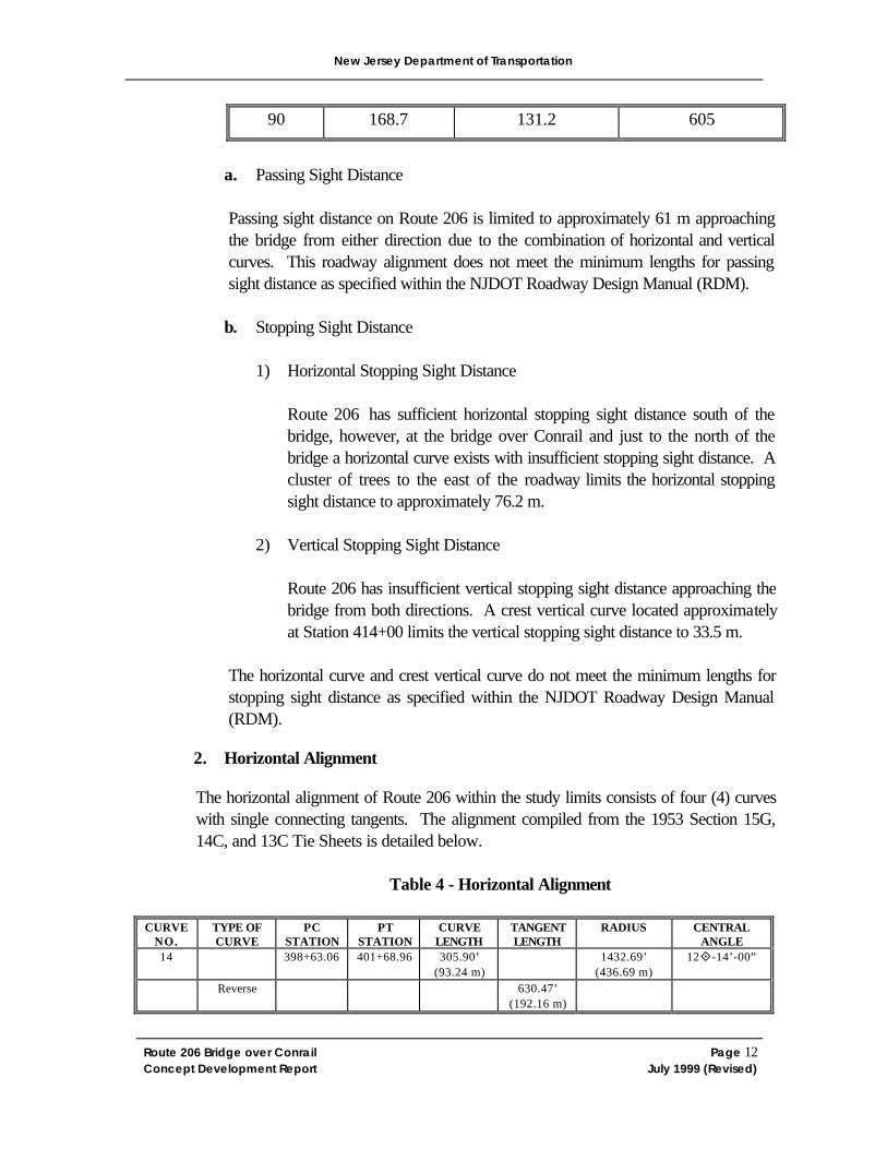
80 139.4 112.8 541
New Jersey Department of Transportation
Route 206 Bridge over Conrail Page 12 Concept Development Report July 1999 (Revised)
90 168.7 131.2 605
a. Passing Sight Distance Passing sight distance on Route 206 is limited to approximately 61 m approaching the bridge from either direction due to the combination of horizontal and vertical curves. This roadway alignment does not meet the minimum lengths for passing sight distance as specified within the NJDOT Roadway Design Manual (RDM). b. Stopping Sight Distance
1) Horizontal Stopping Sight Distance
Route 206 has sufficient horizontal stopping sight distance south of the bridge, however, at the bridge over Conrail and just to the north of the bridge a horizontal curve exists with insufficient stopping sight distance. A cluster of trees to the east of the roadway limits the horizontal stopping sight distance to approximately 76.2 m.
2) Vertical Stopping Sight Distance
Route 206 has insufficient vertical stopping sight distance approaching the bridge from both directions. A crest vertical curve located approximately at Station 414+00 limits the vertical stopping sight distance to 33.5 m.
The horizontal curve and crest vertical curve do not meet the minimum lengths for stopping sight distance as specified within the NJDOT Roadway Design Manual (RDM).
2. Horizontal Alignment
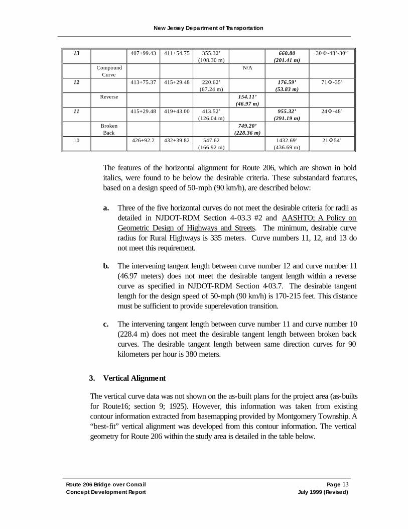
The horizontal alignment of Route 206 within the study limits consists of four (4) curves with single connecting tangents. The alignment compiled from the 1953 Section 15G, 14C, and 13C Tie Sheets is detailed below.
Table 4 - Horizontal Alignment
CURVE
NO. TYPE OF CURVE
PC STATION
PT STATION
CURVE LENGTH
TANGENT LENGTH
RADIUS CENTRAL ANGLE
14 398+63.06 401+68.96 305.90’ (93.24 m)
1432.69’ (436.69 m)
12°-14’-00”
Reverse
630.47’ (192.16 m)
New Jersey Department of Transportation
Route 206 Bridge over Conrail Page 13 Concept Development Report July 1999 (Revised)
13 407+99.43 411+54.75 355.32’ (108.30 m)
660.80 (201.41 m)
30°-48’-30”
Compound Curve
N/A
12
413+75.37 415+29.48 220.62’ (67.24 m)
176.59’ (53.83 m)
71°-35’
Reverse
154.11’ (46.97 m)
11
415+29.48 419+43.00 413.52’ (126.04 m)
955.32’ (291.19 m)
24°-48’
Broken Back
749.20’ (228.36 m)
10 426+92.2 432+39.82 547.62 (166.92 m)
1432.69’ (436.69 m)
21°54’
The features of the horizontal alignment for Route 206, which are shown in bold italics, were found to be below the desirable criteria. These substandard features, based on a design speed of 50-mph (90 km/h), are described below: a. Three of the five horizontal curves do not meet the desirable criteria for radii as
detailed in NJDOT-RDM Section 4-03.3 #2 and AASHTO; A Policy on Geometric Design of Highways and Streets. The minimum, desirable curve radius for Rural Highways is 335 meters. Curve numbers 11, 12, and 13 do not meet this requirement.
b. The intervening tangent length between curve number 12 and curve number 11 (46.97 meters) does not meet the desirable tangent length within a reverse curve as specified in NJDOT-RDM Section 4-03.7. The desirable tangent length for the design speed of 50-mph (90 km/h) is 170-215 feet. This distance must be sufficient to provide superelevation transition.
c. The intervening tangent length between curve number 11 and curve number 10 (228.4 m) does not meet the desirable tangent length between broken back curves. The desirable tangent length between same direction curves for 90 kilometers per hour is 380 meters.
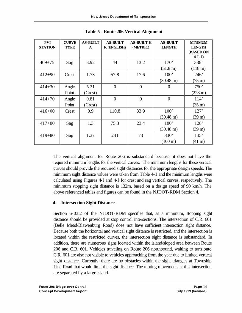
3. Vertical Alignment
The vertical curve data was not shown on the as-built plans for the project area (as-builts for Route16; section 9; 1925). However, this information was taken from existing contour information extracted from basemapping provided by Montgomery Township. A “best-fit” vertical alignment was developed from this contour information. The vertical geometry for Route 206 within the study area is detailed in the table below.
New Jersey Department of Transportation
Route 206 Bridge over Conrail Page 14 Concept Development Report July 1999 (Revised)
Table 5 - Route 206 Vertical Alignment
PVI STATION
CURVE TYPE
AS-BUILT A
AS-BUILT K (ENGLISH)
AS-BUILT K (METRIC)
AS-BUILT LENGTH
MINIMUM LENGTH
(BASED ON 4-I, J)
409+75 Sag 3.92 44 13.2 170’ (51.8 m)
386’ (118 m)
412+90 Crest 1.73 57.8 17.6 100’ (30.48 m)
246’ (75 m)
414+30 Angle Point
5.31 (Crest)
0 0 0 750’ (228 m)
414+70 Angle Point
0.81 (Crest)
0 0 0 114’ (35 m)
416+00 Crest 0.9 110.8 33.9 100’ (30.48 m)
127’ (39 m)
417+00 Sag 1.3 75.3 23.4 100’ (30.48 m)
128’ (39 m)
419+80 Sag 1.37 241 73 330’ (100 m)
135’ (41 m)
The vertical alignment for Route 206 is substandard because it does not have the required minimum lengths for the vertical curves. The minimum lengths for these vertical curves should provide the required sight distances for the appropriate design speeds. The minimum sight distance values were taken from Table 4-1 and the minimum lengths were calculated using Figures 4-I and 4-J for crest and sag vertical curves, respectively. The minimum stopping sight distance is 132m, based on a design speed of 90 km/h. The above referenced tables and figures can be found in the NJDOT-RDM Section 4.
4. Intersection Sight Distance
Section 6-03.2 of the NJDOT-RDM specifies that, as a minimum, stopping sight distance should be provided at stop control intersections. The intersection of C.R. 601 (Belle Mead/Blawenburg Road) does not have sufficient intersection sight distance. Because both the horizontal and vertical sight distance is restricted, and the intersection is located within the restricted curves, the intersection sight distance is substandard. In addition, there are numerous signs located within the island/sloped area between Route 206 and C.R. 601. Vehicles traveling on Route 206 northbound, waiting to turn onto C.R. 601 are also not visible to vehicles approaching from the year due to limited vertical sight distance. Currently, there are no obstacles within the sight triangles at Township Line Road that would limit the sight distance. The turning movements at this intersection are separated by a large island.
New Jersey Department of Transportation
Route 206 Bridge over Conrail Page 15 Concept Development Report July 1999 (Revised)
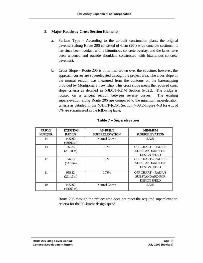
5. Major Roadway Cross Section Elements
a. Surface Type - According to the as-built construction plans, the original pavement along Route 206 consisted of 6.1m (20’) wide concrete sections. It has since been overlain with a bituminous concrete overlay, and the lanes have been widened and outside shoulders constructed with bituminous concrete pavement.
b. Cross Slope - Route 206 is in normal crown over the structure; however, the
approach curves are superelevated through the project area. The cross slope in the normal section was measured from the contours on the basemapping provided by Montgomery Township. This cross slope meets the required cross slope criteria as detailed in NJDOT-RDM Section 5-02.2. The bridge is located on a tangent section between reverse curves. The existing superelevation along Route 206 are compared to the minimum superelevation criteria as detailed in the NJDOT-RDM Section 4-03.2-Figure 4-B for emax of 6% are summarized in the following table.
Table 7 – Superelevation
CURVE
NUMBER EXISTING RADIUS
AS-BUILT SUPERELEVATION
MINIMUM SUPERELEVATION
14 1432.69’ (436.69 m)
Normal Crown 5.72%
13 660.80 (201.41 m)
2.8% OFF CHART – RADIUS SUBSTANDARD FOR
DESIGN SPEED 12 176.59’
(53.83 m) 3.9% OFF CHART – RADIUS
SUBSTANDARD FOR DESIGN SPEED
11 955.32’ (291.19 m)
0.73% OFF CHART – RADIUS SUBSTANDARD FOR
DESIGN SPEED 10
1432.69’ (436.69 m)
Normal Crown 5.72%
Route 206 through the project area does not meet the required superelevation criteria for the 90-km/hr design speed.
New Jersey Department of Transportation
Route 206 Bridge over Conrail Page 16 Concept Development Report July 1999 (Revised)
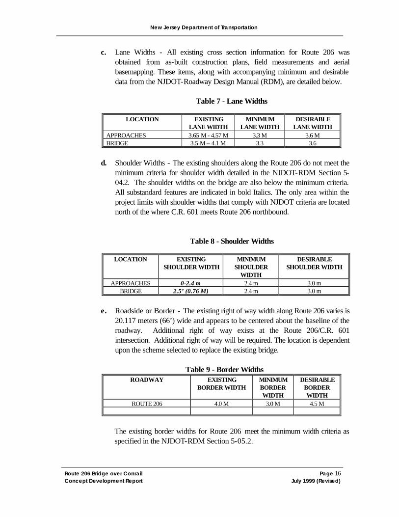
c. Lane Widths - All existing cross section information for Route 206 was obtained from as-built construction plans, field measurements and aerial basemapping. These items, along with accompanying minimum and desirable data from the NJDOT-Roadway Design Manual (RDM), are detailed below.
Table 7 - Lane Widths
LOCATION EXISTING LANE WIDTH
MINIMUM LANE WIDTH
DESIRABLE LANE WIDTH
APPROACHES 3.65 M - 4.57 M 3.3 M 3.6 M BRIDGE 3.5 M – 4.1 M 3.3 3.6
d. Shoulder Widths - The existing shoulders along the Route 206 do not meet the
minimum criteria for shoulder width detailed in the NJDOT-RDM Section 5-04.2. The shoulder widths on the bridge are also below the minimum criteria. All substandard features are indicated in bold Italics. The only area within the project limits with shoulder widths that comply with NJDOT criteria are located north of the where C.R. 601 meets Route 206 northbound.
Table 8 - Shoulder Widths
LOCATION EXISTING SHOULDER WIDTH
MINIMUM SHOULDER
WIDTH
DESIRABLE SHOULDER WIDTH
APPROACHES 0-2.4 m 2.4 m 3.0 m BRIDGE 2.5’ (0.76 M) 2.4 m 3.0 m
e. Roadside or Border - The existing right of way width along Route 206 varies is
20.117 meters (66’) wide and appears to be centered about the baseline of the roadway. Additional right of way exists at the Route 206/C.R. 601 intersection. Additional right of way will be required. The location is dependent upon the scheme selected to replace the existing bridge.
Table 9 - Border Widths
ROADWAY
EXISTING BORDER WIDTH
MINIMUM BORDER WIDTH
DESIRABLE BORDER WIDTH
ROUTE 206 4.0 M 3.0 M 4.5 M
The existing border widths for Route 206 meet the minimum width criteria as specified in the NJDOT-RDM Section 5-05.2.
New Jersey Department of Transportation
Route 206 Bridge over Conrail Page 17 Concept Development Report July 1999 (Revised)
f. Curbs – Concrete NJ barrier curbs were constructed against the through girders across the bridge and vertical curb exists along Route 206 from Township Line Road north through the intersection of Blawenburg Road.
g. Sidewalks - There are no existing sidewalks along the roadway within the study limits along Route 206; however concrete sidewalks supported on cantilever brackets extending from the girders are provided on each side of the bridge.
h. Medians - There are no medians within the project area.
i. Bridges (Lateral and Vertical Clearances) – There is currently only one railroad track under the bridge. The minimum vertical clearance over this track is 22’-4” (6.8 m) and the minim lateral clearance is 31’ (9.4 m).
There are three unsignalized intersections within the study limits. These include the intersection of Route 206 with Township Line Road (Pike Run) at milepost 62.62, a local road that provides access to Township Line Road at milepost 62.71, and Blawenburg Road (C.R. 601) at milepost 62.80. There are no signalized intersections within the project limits.
7. Interchanges
There are no major interchanges within the project limits.
8. Posted Speed Limits
The posted speed along Route 206 from milepost 62.5 to 62.8 is 50 miles per hour (mph). The posted speed is reduced to 45 miles per hour from 62.8 to the northerly limit of the project. As per Table 2-1 of the NJDOT RDM, the design speeds for an existing highway with a posted speeds of 50 mph and 45 mph are 90 kilometers per hour (55 mph) and 80 kilometers per hour (50 mph), respectively.
There are speed warning signs and flashing warning lights to warn drivers of the sharp curve located north of the structure. The sign provides a warning speed of 20 mph.
9. Clear Zone
There are several utility poles within the clear zone throughout the project limits not protected by guide rail.
New Jersey Department of Transportation
Route 206 Bridge over Conrail Page 18 Concept Development Report July 1999 (Revised)
10. Guide Rail
W-Beam guide rail with rub rail is located along Route 206 in both directions of travel from Township Line Road to Blawenburg Road. It should be noted that in conjunction with this project the guide rail will be replaced and utility poles relocated. The guide rail end treatments do not conform to current standards and should be updated with Slotted Guide Rail Terminals. In addition, the guide rail face should be located 3m off the gutter line for roadways with posted speeds of greater than 40 mph. The utility poles should be located 1.2 meters behind the face of guide rail. The guide rail and utility poles should be relocated to provide the desirable offsets when relocated in conjunction with this project.
11. Hydraulic/Drainage
a. Roadway – There is no existing drainage system within the study area. The closest inlet is located approximately 500 feet south of the project on Route 206. The addition of inlets and pipe in the immediate vicinity of the bridge will be included in the project’s design.
b. Waterways – There are no existing waterways within the study area. 12. Lighting
Highway lighting is provided at the intersection of Route 206 & Blawenburg Road and at the intersection of Township Line Road.
13. Signing
There is a No Left Turn sign (R3-2) located at the intersection of Township Line Road and at Blawenburg Road. There are destination signs located at the intersection of Route 206 with Blawenburg Road for Hopewell/Somerville and the Carrier Foundation. The entrances from Blawenburg Road to Route 206 northbound and southbound, and the Route 206 northbound ramp to Blawenburg Road are controlled with a Stop Sign (R1-1). In addition, there are chevrons (W1-6) signs located at the sharp curve on the northwest side of the structure, accompanied by pole-mounted flashing warning lights.
14. Pavement Markings
Pavement markings consist of a solid double yellow line separating the northbound and southbound lanes and a solid white line in either direction detailing the shoulders. Gore striping is provided at the split of C.R. 601 (Blawenburg Road) from Route 206
New Jersey Department of Transportation
Route 206 Bridge over Conrail Page 19 Concept Development Report July 1999 (Revised)
southbound. A left turn lane from Route 206 southbound to Township Line Road is also striped.
15. Pavement Conditions
The existing pavement is in good condition on Route 206. Route 206 is not on the 1996-97 Pavement Management Priority List. To date, no Pavement Inventory Data has been received with regard to Ride Quality Index (RDI), Surface Distress Index (SDI) and Rut Depth (RUT).
16. Access
There are 8 residential or commercial driveways located within the project limits. According to the New Jersey State Highway Access Management Code dated March 1997 – Appendix B, Route 206 has a desirable typical section (DTS – 4A) of 4 lanes, divided, with shoulders or parking, and a desirable right of way width of 114 feet. The desired access level is AL-3, which includes right-turn access with provision for left-turn access via a jughandle.
17. Utilities
A detailed utility investigation of the study area has not been performed to date. From the field investigation, it was noted that overhead electric, telephone, and cable TV are present along Route 206 north of the bridge, but follow C.R. 601 rather than continuing across the bridge. The utility pole lines are on west side of Route 206. Coordination with the utility companies will be required to complete any improvements to the approaches.
The following is a list of the utility companies located within the Montgomery Township as provided by the Montgomery Township Engineering Department. Each of the utility companies identified does not necessarily have facilities within the project limits. Company Utility Elizabethtown Water Company Water Montgomery Township Sewer Transcontinental Gas Pipe Line Gas Public Service Electric and Gas Gas Public Service Electric and Gas Electric Bell Atlantic- New Jersey Telephone United Telephone Telephone AT&T Telephone C-TEC Cable
New Jersey Department of Transportation
Route 206 Bridge over Conrail Page 20 Concept Development Report July 1999 (Revised)
It is anticipated that the realignment of Route 206 and the construction of a new bridge will require the relocation of existing utility poles and adjustment of manholes and valve boxes.
The bridge crosses over an active railroad line within the project area so coordination with the railroad will be required for this project. The track and right of way were previously owned by Conrail, but have been sold to CSX Company. The contact person for Conrail is Mr. Fran Giacoma, (609) 231-2453. The CSX contact person is Mr. Carl Roe.
18. Jurisdiction
The New Jersey Department of Transportation currently maintains jurisdiction of Route 206 within the study limits. However, because of the impending Route 206 Bypass project, this section of Route 206 will accommodate primarily local traffic. The jurisdiction of each of these segments will likely be modified if the Route 206 Bypass project is completed.
19. Pedestrian/Bicycle Compatibility
Accommodations for bicycles and pedestrians will be implemented according to NJDOT standards (Bicycle Compatible Roadways and Bikeways). No sidewalks are currently available within the project limits, except for over the bridge. Conversations with the County of Somerset and the Township of Montgomery indicate that there are several planned bike paths throughout Montgomery Township. These paths are intended to connect parkland on opposite sides of the community. Kent Scully, the township engineer, will send the master plan of the community to the NJDOT BPSD so the bicycle needs can be addressed. There is an area within the township where the township will require a crossing of Route 206. If possible, based on the planned location of the crossing, the NJDOT will try to aid the township with the crossing.
20. Intelligent Transportation Systems
No Intelligent Transportation Systems (ITS) exist within the investigation limits. However, if the bridge is replaced, the ITS Unit requested that two 2” rigid metallic conduits be installed in the new structure for use in a future computerized traffic signal system along Route 206.
21. Landscape
The existing landscaping in the area includes grass berms. Outside of the berm areas, the area is densely vegetated with mature trees. Proposed landscaping for this project will mainly include turf repair within the ROW limits.
New Jersey Department of Transportation
Route 206 Bridge over Conrail Page 21 Concept Development Report July 1999 (Revised)
E. Existing Structure(s) Inventory & Deficiencies
1. Structures & Bridges
Structure No. 1810-156 carrying Route 206 over Conrail was constructed in 1918. It is a single span riveted steel through plate girder structure with a skew angle of 0 degrees. The substructure consists of concrete gravity full height abutments supported on spread footings founded on soil. The overall length of the bridge is 85’ and it is 34’ center to center of through girders.
The bridge roadway carries two lanes of traffic and is 29.8’ wide between curbs. There are concrete NJ barrier curbs constructed against the through girders on each side of the roadway. Outside of each through girder is a 6’ wide concrete sidewalk supported on cantilever brackets extending from the girders. The steel beam approach guide rail is attached to the barrier curb at all four corners of the bridge.
The bridge is in overall critical condition due to its low inventory ratings. The deck is in poor condition exhibiting leakage and fine random cracks with efflorescence throughout 60% of its underside. There is also a large spall with exposed rusted rebars at the southwest corner on the underside of the slab.
The superstructure is in poor condition. The concrete encasements of both through girders are deteriorated, exposing structural steel with moderate to severe rust. The west girder has severe rust with section loss of up to 20% and complete loss to several rivet heads on the bottom flange near midspan. The concrete encasement of the floorbeams has spalled off exposing severely rusted bottom flanges with section losses of up to 30%.
The substructure is also in poor condition. Both abutments have severe scaling and large spalls at several locations. On the south abutment the areas of severe scaling and disintegration of concrete exceeds 350 SF.
Load Factor ratings were performed in the 7th cycle inspection report and are as follows:
The inventory ratings for the bridge are below the legal loads for the Type 3, 3S2 and 3-3 trucks. The design live load capacity of the bridge for the HS design vehicle is 17 tons, which is less than the current NJDOT design live load of 45 tons.
There is currently only one railroad track under the bridge. The minimum vertical clearance over this track is 22’-4”, and the minimum lateral underclearance is 31 feet.
New Jersey Department of Transportation
Route 206 Bridge over Conrail Page 22 Concept Development Report July 1999 (Revised)
The approach roadway alignment for the bridge is classified as “intolerable” due to the significant speed reduction required at the north approach to the bridge. The vertical alignment and tight horizontal curves at this approach provide poor sight distance for vehicles crossing the bridge.
The bridge is classified as structurally deficient due to its substandard load capacity and to the conditions of the deck, superstructure and substructure. The bridge is also classified as functionally obsolete due to its inadequate roadway width. The sufficiency rating for the structure is 9.0.
2. Noise Walls
There are no noise walls present within the limits of the project.
3. Retaining Walls
There are no retaining walls present within the limits of the project.
4. Sign Structures
There are not sign structures located within the project limits.
5. Culverts
There are not culverts within the project limits.
F. Traffic Data The following information has been provided by the New Jersey Department of Transportation’s Bureau of Mobility Strategies, the NJDOT Straight Line Diagrams, and the New Jersey State Highway Access Management Code:
With regard to the pavement skid resistance, no data has been received on this subject.
The 1998 existing peak hour traffic volumes, as well as the 2017 and 2025 future peak hour volumes were provided by the NJDOT Bureau of Mobility Strategies and can be found in
New Jersey Department of Transportation
Route 206 Bridge over Conrail Page 23 Concept Development Report July 1999 (Revised)
Appendix B. Traffic Volumes for both the Route 206 Build and No-Build Scenarios were provided and are included within Appendix B.
G. Accident Summary and Analysis
The New Jersey Department of Transportation’s Bureau of Traffic Engineering and Safety Programs prepared an accident analysis for Route 206 from milepost 62.50 to milepost 63.10. The time period covered was January 1, 1993 to December 31, 1995. The study area was broken down into two sections. From M.P. 62.5 to 62.85, the area includes four lanes with no median or shoulder. From M.P. 62.85 to 63.10, Route 206 has two lanes with shoulder.
M.P. 62.5 – 62.85 (Four lanes with no median or shoulder) Over this three-year period, this section of Route 206 experienced a total of 53 accidents. The actual accident rate for this project location is 9.51, which is above the 1995 statewide accident rate of 5.93. Of the 53 total accidents, 8 were head-on collisions. These 8 accidents constitute 15.1% of the total accidents. This percentage was significantly higher than the 1995 statewide average of 2% for this type of collision. The following is a summary of the other accidents: 1. 0% (0) fatal accidents occurred on this section. The 1995 statewide average for fatal
accidents is 0.4% 2. 30.2% (16) involved an injury, which is below the 1995 statewide average of
37.6%. 3. 58.5% (31) occurred during dry conditions, which is below than the 1995 statewide
average of 73.7%. 4. 83.0% (44) occurred during the day, which is greater than the 1995 statewide
average of 71.3%. 5. 35.8% (19) occurred during wet surface conditions, which is greater than the 1995
statewide average of 23.0% 6. 5.7% (3) occurred during snow or ice conditions, which is greater than the 1995
statewide average of 3.0%. 7. 81.1% (43) occurred at intersections, which is greater than the 1995 statewide
average of 63.7%. 8. 13.2% (7) involved a fixed object collision, which is greater than the 1995 statewide
average of 10.7%. 9. 69.8% (37) involved property damage. The 1995 statewide average for accidents
involving property damage is 62%. M.P. 62.85 – 63.10 (Two lanes with shoulder) Over this three-year period, this section of Route 206 experienced a total of 20 accidents. The actual accident rate for this project location is 4.60, which is above the
New Jersey Department of Transportation
Route 206 Bridge over Conrail Page 24 Concept Development Report July 1999 (Revised)
1995 statewide accident rate of 3.09. The following is a summary of the 20 total accidents: 1. 0% (0) fatal accidents occurred on this section. The 1995 statewide average for fatal
accidents is 0.4% 2. 25.0% (5) involved an injury. The 1995 statewide average for accidents involving an
injury is 37.6%. 3. 85.0% (17) occurred during dry conditions, which is greater than the 1995
statewide average of 73.7%. 4. 30.0% (6) occurred during the night, dawn, or dusk which is greater than the 1995
statewide average of 28.7%. 5. 55.0% (11) occurred between intersections, which is above the 1995 statewide
average of 36.3%. 6. 75.0% (15) involved property damage, which is greater than the 1995 statewide
average of 62%. 7. 25.0% (5) were angle accidents, which is above the 1995 statewide average of
15.9%. 8. 15.0% (3) were head-on collisions, which is above the 1995 statewide average of
2.0%. 9. 5.0% (1) involved an animal, which is above the 1995 statewide average of 2.0%.
The aforementioned accident summary and collision diagrams based on accident reports between 1995 and 1997 can be found in Appendix E.
IV. Summary of Existing Deficiencies
The following is a list of existing roadway and bridge items that do not meet the minimum criteria from the NJDOT RDM based on the information in the previous sections:
1. Superelevation at the horizontal curves 2. Horizontal curvature 3. Vertical curve lengths along Route 206 4. Vertical sight distance 5. Guide rail end treatments. Guide rail lateral placement, offset of obstructions. 6. Bridge live load capacity 7. Bridge width V. Project Need
A. Restatement of Problem
New Jersey Department of Transportation
Route 206 Bridge over Conrail Page 25 Concept Development Report July 1999 (Revised)
Due to the inadequate superstructure of the Route 206 bridge over Conrail, it is recommended that the structure be replaced in order to meet current NJDOT standards. The approach horizontal and vertical geometry are also substandard, furthering the need for a replacement structure on an alternate alignment.
B. Project Goals & Objectives
It has been determined that there are no substantial constraints (fatal flaws) at the Route 206 Bridge over Conrail. The new bridge will have lane and shoulder widths, and live load capacity conforming to current design criteria. The bridge will likely be constructed on an alternate alignment to allow the traffic to remain on the existing structure while the new bridge is erected. The new alignment will also provide the opportunity to improve the substandard geometry.
VI. Concepts
A. Design Controls
1. Design Standards
The following design standards were used in the development of this project scope:
2. Roadway and Appurtenances
1.) A Policy on Geometric Design of Highways and Streets, AASHTO 1994. 2.) AASHTO - Roadside Design Guide, 1996. 3.) New Jersey Department of Transportation Design Manual - Roadway. 4.) Highway Capacity Manual Special Report 209 Third Edition, 1994. 5.) Manual on Uniform Traffic Control Devices, 1988. 6.) New Jersey State Highway Access Management Code, March 1997 with
Amendments of January 1998 & April 1998
a. Bridges and Structures
1.) New Jersey Department of Transportation Design Manual - Bridges and Structures.
2.) Standard Specifications for Highway Bridges, Sixteenth Edition, AASHTO 1996, and Interim Specifications, Bridges, AASHTO.
3. Controlling Environmental Features
New Jersey Department of Transportation
Route 206 Bridge over Conrail Page 26 Concept Development Report July 1999 (Revised)
The Policy and Special Services Section of the Bureau of Environmental Services prepared an Environmental Screening for the project. As part of the “Fatal Flaw Analysis” the BES identified any constraints that would prevent advancement of the project. Investigations of Cultural Resources, Ecology, Hazardous Waste, and Section 4(f) concluded that there appear to be no environmentally sensitive resources which will preclude construction of the job although the screening identified some constraints that will warrant consideration during design in order to minimize environmental impacts. Although no large wetlands or floodplains exist within the study area, there are manmade ditches associated with the railroad and roadways. If these are affected a general wetland permit may be required. There were no properties within the study area listed with the NJ or National Registers of Historic Places; however, the SHPO feels that the Harlingen Reformed Cemetery is eligible for a listing in the National Register. Furthermore, the Reverand Labagh House is eligible for listing in the National Registry. Finally, concerning hazardous waste there are no contaminated sites within the study area. A copy of the Environmental Screening Report can be found in Appendix F.
3. Stakeholder Input
A meeting was held with the Montgomery Township officials on July 26, 1999 at the Montgomery Township office. It was noted that the Hillsborough Route 206 Bypass project is moving forward. A public information center is scheduled for this project on Thursday, July 29, 1999. This Route 206 bypass will carry a significant percentage of the current Route 206 traffic. Volume projections for the existing Route 206 section over the Conrail bridge show volumes at about 20% of their current volume. Because of the reduced volumes, the NJDOT Value Engineering unit suggested that the existing bridge over Conrail should be maintained until the Bypass is completed. At that time, VE suggested that the existing bridge should be removed and not replaced. The connections between the Bypass and existing Route 206 could be made by nearby roadways, all of which are located in adjacent Hillsborough Township.
The Montgomery officials were opposed to the concept of closing the bridge in this location for several reasons. These include: inconvenience to residents; the post office is located in the northerly section of Montgomery, which would be separated from the rest of the Township; there are several businesses located north of the bridge; emergency response time would be unacceptable to this area. County Route 601 just south of its intersection with Route 206 has very sharp curvature and a significant accident history. It is important to maintain the link from the Township to this area for maximize response time.
It was discussed that several alternatives will be developed and discussed with the Township at future meetings.
New Jersey Department of Transportation
Route 206 Bridge over Conrail Page 27 Concept Development Report July 1999 (Revised)
4. Core Group Input
The NJDOT Core Group has provided responses to the shotgun letters. These responses are include in Appendix C. Each of the issues are discussed in other sections of this report.
5. Permitting Agency Input
No input has been received from NJDEP at the time of writing this report. B. Concept “A”
This concept will provide a replacement structure to the south of the existing structure carrying Route 206 over the railroad tracks. A “T” intersection will be constructed to meet with C.R. 601. However, because of the significant elevation difference between C.R. 601 and the elevation required to span the railroad, the profile of C.R. 601 will have to be at a higher elevation than existing. A traffic signal may be required at the intersection. Other factors that must be investigated with this alternative are the sight distance limitations for vehicles approaching the intersection from the south. In addition, the vertical geometry changes of C.R. 601 may impact adjacent property and may also reflect back to the intersection of C.R. 601 with Reading Boulevard. This project is on Somerset County’s Capital Improvement Plan and is scheduled for construction within the next six years.
C. Concept “B”
Concept “B” will provide a replacement structure on an alignment that traverses the Conrail tracks on a skew. Although the skew angle will increase the length of the structure, and therefore the cost of the structure, the alignment of the roadway can be improved significantly. Impacts to the cultural resources identified within this report along with the geometric benefits derived will be weighed when assessing the alternatives. In addition, because the Hillsborough Bypass project will be constructed, this section of roadway may be accommodating only a small percentage of the volume that currently uses Route 206. Because of this, the design speed of the roadway will be evaluated to determine if lower speeds can be used for design.
D. Concept “C”
As discussed in previous sections of this report, the NJDOT Value Engineering Unit has suggested that the existing Route 206 bridge over Conrail will not be needed upon completion of the Route 206 Bypass project. The recommendation from Value Engineering suggests to merely maintain the structure until the new alignment portion of Route 206 is completed. After which, the access from “new” Route 206 to “old” Route 206 would be accommodated at C.R. 604 (Dutchtown-Harlingen Road) to C.R. 601 (Blawenburg Road) or continue north on
New Jersey Department of Transportation
Route 206 Bridge over Conrail Page 28 Concept Development Report July 1999 (Revised)
“new” Route 206 into Hillsborough Township and use Hillsborough Road, Homestead Road, or the new Route 206 structure over Conrail.
VII. Recommendations
Concept “A” and “B” will be developed during Feasibility Assessment. Each of these concepts provides for the replacement of the existing structure on an alternate alignment. Because the existing structure is a through-girder, staging of the construction to replace the structure in its existing location is not an option, unless the structure were to be designed to be significantly wider than necessary to accommodate the travel lanes and shoulders. Concept “C” was presented to the Montgomery Township officials. It appears that that concept will not be supported by the township because the existing structure provides an important link within the community. VIII. Potential Interim Action Items
The Route 206 Bypass project is not scheduled to begin construction until 2003. The project will continue through 2006. Because it is possible that the replacement of the existing Route 206 structure over Conrail will not take place until after the completion of the Bypass, maintenance of the structure will be necessary to ensure its life during this time. Although the sufficiency rating of the structure is only 9, the geometric deficiencies reduce that rating.
IX. Next Steps
A. Continue coordination with the Route 206 Bypass project.
B. Coordination with the Jurisdictional unit will be required because, with the construction of the Bypass, the “old” Route 206 will function primarily as a local roadway.
C. NJDOT Bureau of Utilities should make initial contact with any of the utility companies within the project limits. Contact Names and Telephone numbers must be obtained.
D. Coordinate with Conrail/CSX/NJ Transit to monitor status of reactivating passenger service on the West Trenton Branch and to identify additional geometric requirements based on their future needs.
E. Determine nearby bicycle facilities existing and planned.
F. Obtain Assessor’s List and property information for parcels adjacent to ROW in project limits.
G. Proceed to Feasibility Assessment.
New Jersey Department of Transportation
Route 206 Bridge over Conrail Page 29 Concept Development Report July 1999 (Revised)
X. Schedule
The project is scheduled for presentation to the Capital Program Committee on December 31, 2000. Feasibility Assessment is scheduled to begin on August 1, 1999 and continue through the year 2000. A community position on the project is expected by November 30, 2000. The schedule of this project must be coordinated closely with the schedule of the Hillsborough Bypass project. The Bypass is scheduled to begin construction in 2003 and continue through 2006. The coordination of schedules between the two projects will be coordinated during Feasibility Assessment after a scheme has been selected.