DEPARTMENT OF THE lNTERlOR U.S. GEOLOGlCAL SURVEY A VEGETATED DUNE FIELD IN CENTRAL ALASKA Flarence R. Collins TO ACCOMPANY MAP MF-1708 SUMMARY A 4,800 mi2 dune field occupies lowlands in central Alaska in a roughly triangular area between the lower Nowitna River, Nenana, and the Alaska Range. The field can be divided into two tracts: (1) the Northwestern Tract, which extends 90 mi west-southwestward from the Tanana River and is separated from the Southeastern Tract by the Kuskokwim Mountains; (2) the Southeastern Tract, which extends southwest from the Tanana River and is 160 mi lone; and a maximum of 50 mi wide. The Southeastern Tract is subdivided by the Kantishna and Muddy Rivers into eastern, central, and southwestern areas. The field is composed mostly of parabolic and longitudinal dunes that are 10 to 150 ft high, 50 ft to 3 mi long, and 50 to 1,000 ft wide. The dunes ace blanketed by loess and forested with birch or aspen; black spruce and muskeg cover the permanently frozen terrain between the dunes. Sand from many dunes in the Southeastern Tract and from cutb~nks of the Kantishna River was sampled; no organic matter, sand wedges, or ice wedges were found, and the sand is generally well sorted, light yellowish gray, and fine grained. It is composed of quartz and chert with some darker rock and mineral grains. Many samples contain a fine- silt-and-clay fraction that causes the distribution curve to be bimodal. The eastern area in the vicinity of Dune Lake hns a sharply defined sand sheet 50 mi long overlain by irregular transverse dunes that in turn are capped by rosettes, small arcuate dunes arranged concentrically in roughly circular groups nbout 1 mi in diameter. They seem to be caused by a combination of local and regional winds. The central area is the largest in area and in volume of sand and contains a few large transverse dunes as well as parabolic and longitudinal ridges; the southwestern area has only the latter. Underlying deposits are exposed along the Kantishna River and consist of alluvial .sand and silt underlain by gravel. Apparently contemporaneous with the aeolian sand are thick silt deposits on the northeast flanks of Bearpaw Mountain and of Castle Rocks, isolated hills that are south- west of the eastern area nnd south of the southwestern area of the dune field. respectively. Shape, orientation, and distribution of the dunes and the silt deposits indicate deposition by wind from the northeast. The source of the sand is undoubtedly the Alaska Range, which furnished alluvium to the north-flowing tributaries of the Tanana River. Dune distribution also suggests a barren landscape near the Tanana River, with scattered clumps of vegetation farther from the source of the sand. Present evidence is consistent with the tentative conclusion that the dunes were deposited in late Wisconsin time. A proposed agricultural development in some townships west of Nenana will disturb the thin vegetative and soil cover and may reactivate dune movement. and the Alaska Range (fig. 1). It con be divided into two major tracts separated by the northeastern part of the Kuskokwirn Mountains. The Southeastern Tract extends about 160 mi southwestward from the Tanana River and has a maximum width of 50 mi, The Kantishna River drains most of its length, and the southwestern part contidues into the basin of the Swift Fork of the Kuskokwim River. The South- eastern Tract is subdivided into an eastern area east of the Kantishna River, a central area west of the Kantishna and north of the Muddy, and a southwestern area to the south of the Muddy River. The Northwestern Tract is nearly 90 mi long and has a maximum width of 30 mi. It extends from the Tanana River west-southwestward to the Nowitna River, which is west of the Fairbanks mapping meridian in the Kateel River meridian area. The Northwestern Tract was not visited on the ground. Except for one small active blowout at Dune Lake (T. 6 S., R. 12 W., map sheet), the dunes are completely vegetated, and the outline of the dune field as shown on the map is based on the distribution of dune ridges visible on vertical aerial photographs (scale approximately 1:40,000). Field work Most of the dune field has been viewed from a small plane, and many dunes in the Southeastern Tract were examined on the ground in 1956. Sections through the dunes exposed in cutbanks of the Kantishna River were examined in 1981. The dunes first came to the attention of Florence Weber and me shortly after we came to Fairbanks, Alaska, to work for the U.S. Geological Survey Navy Oil Unit. On vacations and weekends we flew our small 2-place plane to Lake Minchumina and elsewhere in the territory and were attracted by the unusual ridged patterns of the terrain between Nenana and the lake. Preliminary study of aerial photographs was followed by a summer of field work in 1956, using a plane on floats for transportation. In 1957, Lake Minchumina became my permanent home, and 1 have had continuing opportunities to study the winds, weather, and dunes of central Alaska. lnformation on dune composition was obtained for the most part Prom pits dug in the crests of the dunes we visited; that location was chosen so that samples would be comparable from one dune to another and would be relatively unaffected by slumping or other local disturbance. Silt deposits were sampled near the tops of hills for the same reasons. A few pits were nearly 3 ft square and more than 4 ft deep; the rest were about 2 ft square and 2 ft deep, with an additional 5 ft of depth sampled by means of a soil auger. The sediment sequence was mensurad and described, and samples were taken at various depths to be sieved for grain- size determination (tables 1-7). Unless designated "K.R.M." for Kateel River meridian, all township and range data refer to the Fairbanks meridian, Acknowledgments INTRODUCTION This study would have been impossible without the help of Florence R. Weber from the U.S. Geological Survey and of Location my husband, Richard H. Collins, who shared in the geologic field work and in interpreting the data gathered. The interest A large dune field in interior Alaska cov rs southwest- of Mr. .Joseph T. Flakne and other members of the Arctic 5. trending lowlands that occupy about 4,800 mi In a roughly Institute of North America resulted in some financial support triangular area between the lower Nowitnn River, Nenana, for the early work. More recently, the interest and
Transcript
DEPARTMENT OF THE lNTERlOR U.S. GEOLOGlCAL SURVEY
A VEGETATED DUNE FIELD IN CENTRAL ALASKA
Flarence R. Collins
TO ACCOMPANY MAP MF-1708
SUMMARY
A 4,800 mi2 dune field occupies lowlands in central Alaska i n a roughly triangular area between the lower Nowitna River, Nenana, and the Alaska Range. The field can be divided into two tracts: (1) the Northwestern Tract, which extends 90 mi west-southwestward from the Tanana River and is separated from the Southeastern Tract by the Kuskokwim Mountains; (2) the Southeastern Tract, which extends southwest from the Tanana River and is 160 mi lone; and a maximum of 50 mi wide. The Southeastern Tract is subdivided by the Kantishna and Muddy Rivers into eastern, central, and southwestern areas. The field is composed mostly of parabolic and longitudinal dunes that are 10 to 150 ft high, 50 f t to 3 mi long, and 50 to 1,000 ft wide. The dunes ace blanketed by loess and forested with birch or aspen; black spruce and muskeg cover the permanently frozen terrain between the dunes.
Sand from many dunes in the Southeastern Tract and from cu tb~nks of the Kantishna River was sampled; no organic matter, sand wedges, or ice wedges were found, and the sand is generally well sorted, light yellowish gray, and fine grained. It is composed of quartz and chert with some darker rock and mineral grains. Many samples contain a fine- silt-and-clay fraction that causes the distribution curve to be bimodal.
The eastern area in the vicinity of Dune Lake hns a sharply defined sand sheet 50 mi long overlain by irregular transverse dunes that in turn are capped by rosettes, small arcuate dunes arranged concentrically in roughly circular groups nbout 1 mi in diameter. They seem to be caused by a combination of local and regional winds. The central area is the largest in area and in volume of sand and contains a few large transverse dunes as well as parabolic and longitudinal ridges; the southwestern area has only the latter.
Underlying deposits are exposed along the Kantishna River and consist of alluvial .sand and silt underlain by gravel. Apparently contemporaneous with the aeolian sand a re thick silt deposits on the northeast flanks of Bearpaw Mountain and of Castle Rocks, isolated hills that are south- west of the eastern area nnd south of the southwestern area of the dune field. respectively.
Shape, orientation, and distribution of the dunes and the silt deposits indicate deposition by wind from the northeast. The source of the sand is undoubtedly the Alaska Range, which furnished alluvium to the north-flowing tributaries of the Tanana River. Dune distribution also suggests a barren landscape near the Tanana River, with scattered clumps of vegetation farther from the source of the sand. Present evidence is consistent with the tentative conclusion that the dunes were deposited in late Wisconsin time.
A proposed agricultural development in some townships west of Nenana will disturb the thin vegetative and soil cover and may reactivate dune movement.
and the Alaska Range (fig. 1). It con be divided into two major tracts separated by the northeastern part of the Kuskokwirn Mountains. The Southeastern Tract extends about 160 mi southwestward from the Tanana River and has a maximum width of 50 mi, The Kantishna River drains most of its length, and the southwestern part contidues into the basin of the Swift Fork of the Kuskokwim River. The South- eastern Tract is subdivided into an eastern area east of the Kantishna River, a central area west of the Kantishna and north of the Muddy, and a southwestern area to the south of the Muddy River. The Northwestern Tract is nearly 90 mi long and has a maximum width of 30 mi. It extends from the Tanana River west-southwestward to the Nowitna River, which is west of the Fairbanks mapping meridian in the Kateel River meridian area. The Northwestern Tract was not visited on the ground.
Except for one small active blowout at Dune Lake (T. 6 S., R. 12 W., map sheet), the dunes are completely vegetated, and the outline of the dune field as shown on the map is based on the distribution of dune ridges visible on vertical aerial photographs (scale approximately 1:40,000).
Field work
Most of the dune field has been viewed from a small plane, and many dunes in the Southeastern Tract were examined on the ground in 1956. Sections through the dunes exposed in cutbanks of the Kantishna River were examined in 1981.
The dunes first came to the attention of Florence Weber and me shortly after we came to Fairbanks, Alaska, to work for the U.S. Geological Survey Navy Oil Unit. On vacations and weekends we flew our small 2-place plane to Lake Minchumina and elsewhere in the territory and were attracted by the unusual ridged patterns of the terrain between Nenana and the lake. Preliminary study of aerial photographs was followed by a summer of field work in 1956, using a plane on floats for transportation. In 1957, Lake Minchumina became my permanent home, and 1 have had continuing opportunities to study the winds, weather, and dunes of central Alaska.
lnformation on dune composition was obtained for the most part Prom pits dug in the crests of the dunes we visited; that location was chosen so that samples would be comparable from one dune to another and would be relatively unaffected by slumping or other local disturbance. Silt deposits were sampled near the tops of hills for the same reasons. A few pits were nearly 3 f t square and more than 4 ft deep; the rest were about 2 f t square and 2 f t deep, with an additional 5 f t of depth sampled by means of a soil auger. The sediment sequence was mensurad and described, and samples were taken a t various depths to be sieved for grain- size determination (tables 1-7).
Unless designated "K.R.M." for Kateel River meridian, all township and range data refer to the Fairbanks meridian,
Acknowledgments
INTRODUCTION This study would have been impossible without the help of Florence R. Weber from the U.S. Geological Survey and of
Location my husband, Richard H. Collins, who shared in the geologic field work and in interpreting the data gathered. The interest
A large dune field in interior Alaska cov rs southwest- of Mr. .Joseph T. Flakne and other members of the Arctic 5 . trending lowlands that occupy about 4,800 mi In a roughly Institute of North America resulted in some financial support triangular area between the lower Nowitnn River, Nenana, for the early work. More recently, the interest and
encouragement of David M. Hopkins resulted in collection of more field data and the final preparation of this report. Henry Render and Charles L. Powell I1 of the U.S. Geological Survey contributed time and effort to making the numerous sieve analyses in 1956 and 1981, respectively. Other geolo- gists and co-workers of the U.S. and State Geological Surveys have also been very helpful, sharing relevant facts and theories on the subject of Alaskan sand dunes. W. M. Geertz of Shell Oil Company loaned the aerial photographs from which figure 2 was derived.
DUNE MORPHOLOGY
The dune field ranges in elevation from 400 ft to nearly 1,200 ft above sea level. Isolated bedrock hills projecting above 1,200 ft are generally free of dunes, although sand ridges cross many lower hills. Most of the dunes are parabolic; individual dunes have arms of unequal length that are slightly convex away from the dune axis. They usually meet at an acute angle to form the southwest end of the dune, although a few dunes have broad U-shaped apices. Individual arms may be less than 50 ft to 3 mi long, I0 to 150 ft high. and 50 to 1.000 It wide. The sides of the arms slope equally steeply to the northwest and southeast, generally approaching the angle of repose for sand; the southwest slope of the apex is generally somewhat steeper than the sides. A cross section through a typical arm would have the profile of an abrupt, rather steep, rounded hill. In some cases (such as Carlson Lake, T. 13 S.. B. 22 W.), the apex of the dune has been breached, leaving a narrow gap between the arms. Examples of small dunes enclosed by the arms of a large parabolic dune are very rare.
Longitudinal (windrift) dunes are less common than parabolic ones, but resemble them vety closely except for lacking the accompanying arm. Their long axes parallel the axes of parabolic dunes, and the axes of neighboring dunes are parallel. Although there are slight and gradational variations of a few degrees in the orientation of dune axes from place to place, the axes are remarkably similar throughout each tract, being about southwest in the Southeastern Tract and west- southwest in the Northwestern Tract.
In much of the Northwestern Tract and the north half af the central area, the parabolic dunes overlie large sand ridges that resemble tranverse dunes, but that strike north at a 45O angle to the axes of the parabolic dunes. They are described in the section on the central area.
True transverse dunes are rare, and most of them are located near the Tanana River. They may also be present near Dune Lake in association with the unique rosette dunes. The latter, which are described in more detail in the rosette section, are roughly circular groups of small arcuate dunes that top the crests of what appear to be irregular transverse dunes (fig. 2).
DIRECTION OF SAND TRANSPORT
The distribution, size, and shape of the dunes nearly all indicate deposition by a wind from the northeast. The most massive deposits and the transverse dunes are close to the Tanana River, and the dune deposits diminish to scattered small ridges to the southwest. There is commonly a lack of dune-sand deposits on the southwest, wind-shadow side of isolated bedrock hills. The steepest sides of the dunes face southwest, as do the apices of the parabolic dunes.
VEGETATION
A very noticeable feature of the parabolic and longitudinal dunes is the difference in vegetation between the ridges and the interdune areas. The well-drained dune crests support birch, aspen, white spruce, herbs. and shrubs, and Hchens are found along crestline animal trails. The interdune areas, both between dunes and between dune arms, are com- monly covered with scrubby, small, black spruce and have a muskeg ground cover and permafrost at or near the surface. The contrast is especially striking in the autumn, when leaves of the deciduous trees are gold against the evergreen back- ground.
STRUCTURE AND COMPOSITION
Because the Northwestern Tract was not visited on the ground, discussion in this section applies only to the Southeastern Tract.
The dune sand contains no organic matter or interstitial cementing material; its color, as determined from the Rock- color Chart (Goddard, 19481, is usually a light yellowish gray, and apparently comes from the grains themselves, which are clear, white, or yellowish quartz and chert with some darker grains of chert and other rocks and minerals. Sieve analyses show that most of the sand is well sorted and fine grained. The small fraction below 46 (0.0625 mm) was divided in the dune-crest samples into coarse silt and fine-silt-and-clay fractions; many samples had more of the finest material than of the coarser silt. resulting in bimodal distribution.
Permafrost was absent in every dune crest sampled, and none was visible in any exposures of dune sand in cutbanks of the Kantishna, Toklat, and Foraker Rivers. No ice or sand wedges were noted.
Eastern area
Sand exposed in pit walls in the eastern area was light yellowish gray, uniform, and massive. At the surface of the small blowout dune at Dune Lake the sand is grayish yellow, and in the Toklat River and Kantishna River bluffs it is light yellowish gray. Sand samples from the upper part of the pits are consistently slightly finer grained than those from 4- to 5-ft depths. Horizontally, however, sieve analyses show no clear pattern (table 1). Samples from Dune Lake, the Toklat River, and the bluffs at site 3 are all better sorted (with fine sand dominant) than those from Black Bear and Cabin Lakes farther east. However, these comparisons may not be of great value: the Dune Lake sample is from the surface of the sand, Black Bear and Cabin Lake samples are from depths of 4 to 5 ft below the dune crest, and the Toklat and site 3 samples are from 20 to 100 ft below the surface; the relation of the Toklat and site 3 samples to the dune crests is unknown.
Central area
The only place in this area wher:: crossbedded dune structure is exposed is the large bluff near the mouth of the Kantishna River (T. 2 S., R. 12 W.) called site 6 in this report. This bluff is about 200 ft high and more than a half mile long. The upper 50 ft consists of beds of sand that dip 10' south. The base of this interval has a sharp, horizontal contact with underlying sand beds that dip about 5' south. About 30 ft of the latter are exposed, but the base is covered, and only a few patches gf silty sandy material are exposed in the lower part of the bluff. The upper part of site 4 (T. 6 S., R. 15 W., table 2)is probably dune sand, but it is poorly exposed and lacks crossbedding. Sand exposed in the dune- crest pits was massive and uniform except at Kindanina Lake near the Tanana River, where there were horizontal streaks of medium to coarse sand with rare granules, and a t Pass Lake at the southwestern end of this area, where there were alternating, gradational beds of fine and very fine sand in beds 0.5 to 1 In. thick. Petails are given in table 2.
Sand in this area is light yellowish gray except a t Wien Lake, where it is moderate yellowish brown.
Two general trends are noticeable in the sand samples from the central area: (1) as in the eastern area, sand from any one site becomes slightly coarser with depth; (2) the fine- silt-and-clay fraction ( 0.044 mm) is larger than the coarse- silt fraction (0.0625-0.044 mm), resulting in bimodal distribu- tion in 14 of the 19 samples subdivided in this size range. The proportion of this finest fraction generally increases (except a t Pass Lake) with distance from the Tanana River. The greatest amounts are at Wien Lake (21.8 percent) and Duck Lake (26.9 percent)^ elsewhere the proportion ranges from 0.9 to 8.3 percent. Otherwise, the central, like the eastern area, shows no consistent variations. Kindanina Lake has the coarsest sand, the medium (21) sand slightly outweighing fine (3b) sand; fine sand dominated in most of the other samples.
Iksgiza, East Twin, Duck, and Pass Lakes are nearly In a
straight line and range from 5 to 65 mi southwest (in a down- wind direction) from the Tanana River. Comparison of sand samples (from approximately the same depth) from pits at each location indicates that sand size decreases slightly from East Twin to Pass Lakes. However. the Iksgiza Lake sarnple is the finest grai,ned of the four in spite of being, presumably, nearest the source.
Except for samples from Kindanina and Wien Lakes, sand from the central area is generally similar in size range and color to the well-sorted sands from Dune and Grassy Lakes in the eastern area.
Southwestern area
The only exposures of dune sand are in cutbanks along the Foraker River below its junction with tho Herron River. One exposure near Foraker Pond is described in table 3. Another exposure 4 mi farther north contains, from southwest to northeast, sand with irregular but generally horizontal bedding, a swale containing muck over similar sand. and, a t the highest part of the bank, crossbedded sand. A third cut more than a mile farther north contains coarse to fine snnd with irregular and lenticular bedding.
Sand in samples from east of the Foraker River (from pits at Carlson, Rillberg, and Gosling Lakes, for instance) generally becomes finer with depth. Except for the Foraker Pond samples, however, sand in samples from west of the Foraker Rivcr coarsens with increasing depth. Comparison of samples from depths of 3 to 5 ft across the area (from pits a t Reaverlog, nillberg. Gwling. Carlson, Foraker. Doghouse. Cranberry and Shisnona Lakes) showed no trend. Sand in samples from Doghouse and Cranberry Lakes in the west is the coarsest and is the only sand in which the fine to medium ratio is about equal. The finest grain sand is found in samples from Reaverlog. Gosling, and Shisnona Lakes at the east and west ends of the area; the Beaverlog sample has 81.6 percent and the lat ter two have more than 40 percent of very fine sand, and the cumulative curves from Gosling and Shisnona Lakes are very similar. Except for the Beaverlog Lake sample described above, sand from the Billberg Lake and Foraker Pond samples is the best sorted and is 66.5 percent and 59.4 percent fine grained. respectively; their cumulative curves are also very similar. On the other hand, the sand sample from Carlson Lake is strongly bimodal. and is comprised of 45.6 percent fine sand and 36.6 percent coarse silt (0.0625-0.044mm). An overlying granule-containing stratum is trimodal, containing 29.8 percent coarse sand (with granules to 0.5 cm), 30.6 percent fine sand, and 21.9 percent coarse silt. Both of these samples are from depths of less than 5 f t below the top of a 2 5 4 dune and, hence, from sands that are surely windlaid. Layers 1 to 1.7 ft below the surface a t Foraker Pond and Cranberry Lake also contain coarse sand and granules (see table 3). Coarse sand layers are also present a t slightly greater depths (as deep as 5 f t) in the pit a t Carlson Lake and in the Foraker River cutbank.
Samples used in the above comparisons were similar in containing little of the fine-silt-and-clay fraction ( 0.044 mm). In 25 of the 33 sieve analyses, however, that fraction is larger than the coarse-silt fraction, resulting in a bimodal distribution. In three samples this fraction makes up 24.4 percent, 30.9 percent, and 50.1 percent of the total, probably because they all were collected from just below loess or a soil horizon. The percentage of the fine-silt-and-clay fraction in the rest of the 25 samples is mostly less than 10 percent; the coarse-silt fraction is less than 1 percent in half the samples, less than 8 percent in two of them, and between 2 percent and 4.5 percent in the remainder.
Area comparisons
It is difficult to compare sieve analyses of sand from the southwestern area with those from the central ~ n d eastern areas because of the apparently random variability in the southwestern area (fig. 3). Of the seven comparable samples discussed above, only those from Billberg Lake and Foraker Pond, which contain well-sorted, mostly fine grained sand, resemble the typical sands from the other two arcns. flowever. samples frotn Doghouse and Cranberry Lakes
resemble those from Kindanina Lake in having nearly equal amounts of fine and medium sand. The bimodal distribution, which results from the comparatively large amount of fine silt and clay, seems to be the only characteristic the sieve analyses from this area have in common with sands to the northeast.
DETAILED GEOGRAPHIC DESCRIPTIONS
The Southeastern Tract
The eastern area of the Southeastern Tract is bounded roughly by the Kantishna, Tanana, and Teklanika Rivers and the Totek Hills; there are also a few small patches of dunes north of the Tanana nnd east of the Teklanika Rivers that may be conveniently included here. The central area, largest of the three, is bounded on the north and east by the Tanana and Kantishna Rivers, on the west by the Kuskokwim Mountains, and on the south by the Roosevelt Hills. The southwestern area is separated from the central area by the Roosevelt Hills and lake-dotted flats drained by the Muddy River, but it continues with the same southwesterly trend past Lake Minchurnina to approximately long 153 '~ .
The eastern area
The lowland in which these dunes occur ranges in eleva- tion from less than 300 ft above sea level along the downstream part of the Tanana Hiver to a maximum height of nearly 700 f t in the rosette nren near thc southern boundary. The roughly oval area is nearly 50 mi long and approximately half as wide. The north and east edge is a scalloped bluff of varying height that borders the Tanana Hiver flood plain. An inconspicuous and discontinuous bluff, reduced near the Teklanika River to a terrace several feet high, forms the southeast border. Just north of the Totek Hills, a sharp break in slope marks the south edge of the dunes; it is a composite of erosional cutbanks (in some cases shorelines of lakes set into the edge of the sand) and of the southern depositional limit of the sand blanket itself. The southwest corner is defined by bluffs along the lower Toklat River.
The 1,000 mi of nearly streamless lowland thus enclosed exhibit several types of topography, most of which seem to be developed on sand. The northeastern part of the area has parabolic and longitudinal dunes, some of which a re quite inconspicuous; lakes are interspersed among them. A typical ridge on the west side of Cabin Lake (T. 1 S., R. 9 W.) is only 5 f t high. The terrain rises gradually to the south, and south or the latitude of Nennna relief increases somewhat. Paraholic and longitudinal dunes 0.5 mi to nearly 2 mi long are scattered between thc southwest-facing steep lee slopes of small individual sand sheets. Ponds ore scattered through the area a t the base of lee slopes; some have shrunk, and much or all of their former volume has been replaced by marsh.
The northwestern part of the area is occupied by a narrow, keystone-shaped marshy depression about 18 mi long, 4 mi wide a t the southwestern end, nnd more than twice as wide a t the northeast end, At an elevation of about 300 ft, it is as low as the flood plain of the Tanana River a few miles to the north. It is underlain in part by flood-plain alluvium (Pe'w6 and others, 1966) and may represent an ancestral lower Kantisha River. Ponds are common, and two large lakes occupy the southwest end. Clumps of spruce mixed with aspen are scattered through the marsh-like flat, apparently marking slightly higher ground. This depression may be a remnant of the original surface on which the sand dunes were deposited; its straight boundaries are longitudinal, southwest- trending dunes about 25 ft high that seem to override both the marshes and the edgcs of spruce clumps. A small peninsula in the southwest side of Black Bear Lake (T. 3 S., K. 12 W.) contains gravel 2 ft below the surface (F. R. Weber, oral commun., February 1981).
On its southwest edge, the eastern area is truncated by a 150-ft bluff (T. 5 and 6 S., R. 14 W.) cut by the Toklat River in unconsolidated sand. Much of the bluff's slanting surface is covered with vegetation and material slumped from above, but the upper 70 ft of a short north-south exposed section is
crossbedded with dips about 20' to the south. The lower half O F the bluff is horizontally bedded.
Southwest $f the Toklat River flood plain, an area of more than 1 mi is covered by dunes that have about the same elevation and orientation as those northeast of the Toklat. This small area is bounded on the east, north, and west by cutbanks bordering the flood plains of the Toklat and Kantishna Rivers; alluvium and small tributaries of the Kantishna River form the southern boundary and also divide the dunes into one large and several smaller groups. Pronounced dune ridges are 5 to 25 ft high and 50 ft to 0.5 mi long. Site 3, a bluff on the Kantishna River (map sheet and table I), has furnished a section of the sediments underlying this small group of dunes.
Rwet tes
Surrounding Dune Lake is a sand sheet about 7 m i long and 5 mi wide that has sharply defined southwest-trending tongues in the southwest part. Dunes that have more relief than any others in the dune field occupy the center of the sheet; associated with them are dunes of a unique shape herein termed "rosettes". A sketch (fig. 2) derived from large-scale aerial photographs illustrates the sand sheet. The rosettes consist of groups of small arcuate dunes ranging from 5 or 6 ft to 30+ ft high and 1,000 ft to 2 m i long; their steepest slopes are on the convex outer sides. They are arranged concentrically, and each arc is concave toward a slightly depressed center, resulting in a pattern like a multi- petalled rose roughly 1 mi across (fig. 4). The rosettes occupy some of the highest terrain in the vicinity, and the total relief between the dunes and interdune ponds (of which Dune Lake is much the largest) is greater than 200 It. t i t t le of this relief is accounted far by the small arcuate dunes themselves; the overall pattern suggests that they are developed on or near the crests of large, possibly transverse, dunes.
The origin of the rosettes is uncertain, but some topo- graphic clues point toward a possible explanation: (1) their locations suggest that the rosettes developed close to the crests of large transverse dunes that had been deposited by wind from the northeast; (2) the east side of Dune Lake is bordered by large, mostly vegetated dunes, which have crests 100 ft or more above the lake that were the result of wind from the southwest; and (3) the northern rosettes, especially, have larger, more massive arcs on their northern sides. The present wind regime, as observed during many flights across the area in small planes and from snow-drift patterns, consists mostly of (1) strong northeast winds of dry, cold air in winter; (2) less common storm winds from the southwest, mostly in summer; and (3) occasional strong, very local winds from the southeast that blow down the Nenana River canyon from the Alaska Range and that extend to this part of the dune field, but do not reach to other parts of the field. This combination of winds could account for this most unusual localized pattern. Similar small arcuate dunes are present on the crests of large dunes in the northwest part of the central area of the dune field (T. 1 S., R. 17 W., for example); these do not form rosettes because they are all concave to the northeast. This also tends to support the theory that the rosettes are the result of a unique and local wind regime.
The sharp relief, lack of any developed drainage system, and location atop a sharply defined sand sheet suggest that the rosettes are the youngest of any dunes in the field. The only exposed sand in the region occupies two or three small areas on one of the large dunes just east of Dune Lake; in the summer of 1956, blown sand was collecting to the east of grass tufts on the northeast lip of the blowout's steep (33') west-sloping surface.
North of the Tanana River
East of the Tolovana River and north of the Tanana River is a flat, marshy expanse known as the Minto Flats, much of which is lake covered. East of Swanneck Crossing, at the northernmost curve of the Tanana River, old water- filled meander scars are prominent, becoming fainter to the north. Beyond them, away from the river, are marshy lakes
that range from a few feet to 4 mi long and that have very irregular outlines. Most are narrow, and many show a rough south-southwest orientation. Ten miles north and east of Swanneck Crossing the level surface of the flats is interrupted by a few low aspen- and brush-covered hills that rise as much as 25 ft above the marsh. The hills are mostly 1 mi or so long and about 0.5 mi wide. These gentle elevations have irregular outlines, but are always made up of south- southwest-oriented ridges separated by narrow, shallow swales that lie above the level of the surrounding lowlands. The northeast edges of some hills are abrupt, as though they had been cut by a northwest-trending stream. The hills are judged to be remnants of dunes on the basis of topographic expression; none were visited.
Farther west the lowland is mostly occupied by meander scan and by mud flats on which tributaries and distributaries of both rivers are now depositing alluvium. Within this area of low ground are some lakes and some rather distinct patches of dunes consisting of low hills marked with south- southwest-trending ridges. The largest area is more than 2 mi across, and has some V-shaped dunes that have apices at the south-southwest. The southwest edge of the dunes appears unaffected by subsequent erosion, but the northeast edge has been sharply truncated. A typical dune ridge, located near the east side of this group, borders a bay of Grassy Lake (T. 1 N., R. 10 W.); the ridge is separated from the bay by about 100 ft of grassy marsh. To the northeast, the dune merges with other parallel ridges, but the southwest end is only about 100 ft wide at the base. It rises abruptly from the marsh, attaining a height of about 25 It along its nearly level crest. A 5-ft pit in the dune crest penetrated a little humus and some loess before encountering sand (table 1). A sample from the bottom of the pit is slightly better sorted and slightly coarser than the upper one, but both are typical dune sand and have sieve analyses similar to those from the Toklat River bluff and Dune Lake.
South of Nenana
Three small groups of dunes are located 2 to 4 mi southeast of Nenana. They are 2 mi or less long and a few 100 ft to 0.75 mi wide, differing more because of accidents of erosion than because of differences in original size. Their present outlines are irregular, but each area is crossed by more or less distinct ridges all oriented in an east-northeast direction. The dunes rise about 25 ft above the lowland surface and support a young birch and aspen forest, in con- trast to the stunted black spruce, tamarack, and muskeg of their surroundings. A road cut exposes 5 ft of crossbedded sand; a sand sample from a pit in this dune, taken from 2.5 ft below the surface, is finer grained than sand samples from Grassy Lake and was overlain by 2.1 ft of yellowish-brown silty clay (table 1).
A small I-mi by 0.5-mi dune-covered surface just west of Nenana is distinctly higher than the flood plain that sur- rounds it. It is about half way between the main part of the northeast-trending dunes to the west and the east-northeast- trending dunes; its Paint ridges parallel the latter.
The central area
The north and northeast edges of this massive sand body are formed by the terraces bordering the south side of the Tanana River flood plain, and much of the southeast edge is the cut bank on the west side of the Kantishna River flood plain. These boundaries are sharp and comparatively straight, but the rest of thh area is bounded by very irregular and less distinct edges determined by the effect of topography on the deposition of sand moved by a wind from the northeast.
Near the Tanana River, which here flows roughly north- west, are a few ridges that strike northwest and have steep southwest slopes; these ridges are probably transverse dunes (map sheet, T. 1 N., R. 16 W.; T. 1 S., R. 1 5 W.; T. 2 S., R. 13 W.). South of these, the dunes form a veritable sea of sand; they have long wave crests as much as 200 ft or more above the troughs. These dunes, too, are asymmetrical and have steep western slopes; the sinuous crests, which strike north- south, appear to be composed of coalesced sides and apices of
parabolic dunes. Many of the crests curve sharply to the northeast at the north end and diminish in height or are overriden by another wave of sand. See T. 3 and 4 S., R. 1 5 W. for examples. Comparatively small longitudinal dunes superimposed on the gentle windward slopes of the north- south sand ridges southwest; group of small arcuate dunes that top some of the mast prominent, large sand ridges are concave to the northeast and have steep southwest slopes. Undrained depressions at the bases of the massive dunes contain long, narrow marshes or ponds, and some of the western ones are drained by small tributaries of the Zitziana River. The steep lee slopes are covered with grass and scattered birch or aspen; crests support the same trees and a scattering of spruce, Gentle slopes, depressions, and interdune areas are forested with spruce.
Surrounding these massive deposits, except at the north, are longitudinal dunes interspersed with parabolic dunes that have apices to the southwest. Near East and West Twin Lakes and Wien Lake, dunes have encroached on bedrock hills that rise 200 ft or more above the dune-filled lowland to the north and that cast duneless "wind shadowslt to the southwest. Farther south beyond this group of hills, the massive dunes are absent; parabolic and longitudinal dunes continue to the Roosevelt Hills, about 40 mi to the southwest. The dunes are 3 to 50 ft high and 100 ft to more than 0.5 mi long.
North-trending dunes
Two small groups of longitudinal and parabolic dunes that strike north-south are located near the Kantishna River in T. 4 S., R. 13 W. and inT. 7 S., R. 16 W. Bothgroupsare on surfaces that are about 30 ft above the river flood plain but 100 ft below the dune-field surface. A series of cut banks (sites 7, 7A, and 5) intersect the surface underlying the northern group of dunes, and the sections exposed are described in table 4.
The southwestern area
This part of the dune field is much smaller than the central area and lacks the massive sand ridges that dominate the latter. The southwestern area occupies a broad, shallow valley southeast of the Kuskokwim Mountains that is about 40 mi long and less than 15 mi wide. Several small outlying areas are separated from the rest of the dunes by channels and flood plains of the present drainage. Parabolic and longitudinal dunes 300 to 3,300 f t long rise as much as 150 ft above the terrain in the northeast and diminish in height to 30 ft or less in the southwest; only a few are found west of 153' W. Numerous lakes fill shallow depressions between dunes and in a few place surround the dune ends, as at Carlson and Billberg Lakes. Lake elevations rise from 660 ft in the northeast to 850 ft in the southwest, as the terrain gradually rises to form part of the regional divide between the Yukon and Kuskokwim River drainages. Most of the lakes have sandy bottoms and the banks are gently sloping except where a dune borders the water. Dune sides slope 2g0 at Carlson Lake, and the slope of the southwestern nose of the large dune at the east side of that lake is 35O; slopes of other dunes are similar.
Just west of the southwest edge of the dune field on the northeast shore of Spirit Lake (T. 14 S., R. 28 W.) is a group of small blowout dunes emplaced by a wind from the southwest.
The northeast end of the dune field is bordered by a strip of comparatively low land (occupied by Lake Minchumina, innumerable smaller lakes, and the Muddy River) that ranges in elevation from 842 ft (on the 1952 1:63,360- scale McKinley D-5 quadrangle) at the lake to about 625 ft at the southeast end of the lowland. Situated within this strip, about 4 mi east of Lake Minchumina and 0.75 mi northwest of the present edge of the dunes, is Sevenmile Hill. The top of this bedrock knob, at an elevation of 862 ft, is about 175 ft above the adjacent ponds and flats and 55 ft above the crest of the highest dune in the vicinity. In a pit dug at the top of the hill, several ventifacts (dreikanters) were found on the weathered bedrock surface under 1 ft of loess. Two other pits, located down the slope to the east at elevations of 730 ft and 700 f t , exposed 0.4 and 1.8 f t of loess, respectively, on
weathered bedrock. The bottom 0.3 ft of the latter hole did, however, contain a little fine to medium sand in interstices of the angular bedrock fragments, but no ventifacts occurred in these pits or in a second pit dug at the top of the hill. The ventifacts imply passage of blown sand over the top of the hill, but no dune forms are known on or immediately upwind from it. Whether the sand-blasting material has since been removed or whether the loess shaped the ventifacts as it blew by, the ventifacts are witness to the passage of rapidly moving, wind-blown material 100 f t or more above the local terrain.
Higher land surrounds the rest of the area-outliers of the Kuskokwim Mountains, smaller isolated hills, and alluvial deposits of rivers that flow from the Alaska Range.
The Northwestern Tract
The Tanana River flows northwest (see map sheet) from the mouth of the Cosna River to its junction with the Yukon River, and its flood plain marks the northeast edge of the Northwestern Tract of the dune field. This part of the field extends west-southwest to the flood plain of the Nowitna River, some 90 mi away. The northeast edge of what appears to be a massive sand body rises from the flood plain elevation of a little more than 200 ft to a gently undulating surface nearly 600 ft higher. The surface is drained to the north and south by a series of small subparallel streams incised as little as 10 f t to as much as 150 ft and spaced 1 to 3 mi apart. The streams appear to occupy valleys at the base of rather steep, west-facing lee slopes. Most of the east-flowing gullies draining into these streams are longer than those on the western slopes, and many of the interstream divides are closer to the western stream than to the eastern one. Streams in T. 9 to 10 S., R. 28 and 29 E. (K. R. M.) are perpendicular to the west-southwest trend of the sand mass and probably are boundaries of transverse dunes; streams between these and the Tanana River flow more near18 north or south, following depressions at an approximate 45 angle to the axes of the parabolic dunes. The streams thus outline what are probably sand ridges on which the much smaller parabolic and longitudinal dunes are superimposed; the latter are most common on the flanks of the dune field.
The north edge of the east half of this tract extends west-southwest from the junction of the Yukon and Tanana Rivers; the southern boundary is formed by lake-bed deposits that occupy the basin of the Chitanana River just southeast of the dunes (Chapman and others, 1975). A shallow pit in a low ridge on the southwest side of Redlands Lake (T. 3 S., R. 24 W.), 20 ft above the lake but within the lake-bed area as mapped by Chapman, Yeend, and Patton (1975), disclosed 0.2 ft of humus, 0.4 ft of medium%ray mineral soil, and 1.7 ft of very slightly silty, medium-gray clay. A 50-ft cutbank of the Chitanana River, less than 0.5 mi northwest of the lake, exposes light-buff, horizontally bedded clayey silt.
The undulating surface and subparallel streams are absent west of R. 28 E. (K. R. M.), and the dune field is composed entirely of parabolic and longitudinal dunes. Hills in the area commonly have dunes mounting their eastern slopes to a variable height that averages 1,150 ft; the hills cast a "wind shadow" to the west in which dunes are lacking. The northern and southern boundaries of this part of the field are abrupt and depositional and were evidently determined by the effect of the topography on the wind-both the edge of the tract and the edge of the lowland that contains it have the same west-southwest trend. The western boundary is formed by old cutbanks marking the east edge of the Nowitna River flood plain, which, at an elevation of about 250 ft, is a t least 200 ft lower than the gently rolling, lake-dotted surface underlying the dunes. As seen from a small plane, two cutbanks on Grand Creek (T. 10 S., B. 27 E., K. R. M., and T. 10 S., R. 28 E., K. R. M.) and one on the Big Mud River (T. 11 S., R. 29 E., K. R. M.) have the color, angle of repose, and texture of loose sand.
OTHER QUATERNARY DEPOSITS
Alluvium
For most of the Northwestern Tract, no evidence is now
available to determine the type of material underlying the dunes. The eastern part of the dune field, however, appears to be largely underlain by alluvium. Material underlying the dune sand is exposed only in a few cutbanks of the Kantishna River, where unconsolidated alluvium occurs in lenticular or horizontal beds of, silt, sand, and gravel. Some of the sections above the junction with the Toklat River have horizontal or steeply north-dipping gravel beds at the base. Details of these sites are shown in tables 1, 2, 4, and 5. Elsewhere in the Southeastern Tract other indications that the dunes lie on alluvium ere:
1. On a small peninsula on the southwest side of Black Bear Lake gravel was found in a dug hole at a depth of 2 f t (F. R. Weber, oral commun., February 1981).
2. A dry hole west of Nenana (Union 011 of California Nenana No. 1) drilled into gravel a t a depth of 140 ft.
3. Northwest of Bearpaw Mountain, in the central area, there are a few small patches of polygonal ground in the interdune areas. A 2.4-ft pit in the interdune area beside Pass Lake (T. 9 S., R. 20 w.) penetrated frozen, slightly sandy, silty mud. These data suggest that in the vicinity of Bearpaw Mountain and Pass Lake under- lying material is fine grained or poorly sorted and is now permanently frozen.
4. A 30-ft cutbank along the Foraker River 0.25 mi north of Foraker Pond exposed muck containing plant material a t the base. The t ~ p of the muck rises from about 2 f t to about 1 5 f t above the river a t the north end. The sand that overlies it is slightly finer than that from the Foraker Pond sample and in turn is overlain, at the north end of the cut, by flatlyihg beds of sand, silt, and clay that contain tree branches.
The only site where dune sand was seen to directly overlie bedrock is on the west shore of West Twin Lake.
Outside of the dune field, three localities provide additional information:
1. Along the Foraker River, south (upstream) from the dune field toward the Alaska Range, river banks are low and contain silt. However, southward (upstream) from the vicinity of Castle Rocks (T. 17 S., R. 24 W.), gravel, probably outwash, appears below the dark silt, making a sharp contact that rises gradually as the exposed thickness of gravel increases. Whether or not these sediments continue far enough north to underlie the dunes is unknown.
2. A pit on a small ridge just north of the dunes, on the west shore of North Snohomish Lake (T. 13 S., R. 26 W.), penetrated about 4 f t of poorly sorted, coarse to very fine, silty, clayey sand.
3. Lake sediments in the flats near the Chitanana River, south of the Northwestern Tract, are topographically lower than the dune field.
The contact between underlying material and the dune sand is hard to distinguish in the few places it is exposed. The crossbedded sand at site 6 and a t Toklat Bluff is certainly windlaid, and the horizontal beds there may also be dune sand. Underlying alluvium may be exposed at site 6 and certainly is expmed at sites 3, 4, and 7. At site 7, horizontally bedded sand is separated from the sandy silt below by a sharply defined, horizontal 1-in. stratum of mediumdark-gray clay that may mark the base of windblown sediments.
Sandy silt
Rising against the northeastern flanks of Bearpaw Mountain and Castle Bocks are areas of irregular lake-dotted, spruce-covered terrain that are 150 to 200 f t higher than the
nearby dunes. The deposit near Bearpaw Mountain is southwest of the eastern area of the dune field, and the one near L'astle Rocks is southwest of part of the southwestern arerl. These silty deposits are, therefore, downwind from sand dunes and upwind from sizeable obstructions, relative to the wind that moved the dunes.
Both areas rise above the adjacent dune iield with abrupt, straight northwestern boundaries; their surfaces have a northeast-trending grain, expressed in part by poorly devel- oped, generally northeast- or southwest-flowing streams. In the few spots where deposits underlying the surfaces were sampled, they consisted of unconsolidated very fine sand and silt that differed in color and grain size, as well as location and topographic expression, from the dunes and from the overlying loess blanket.
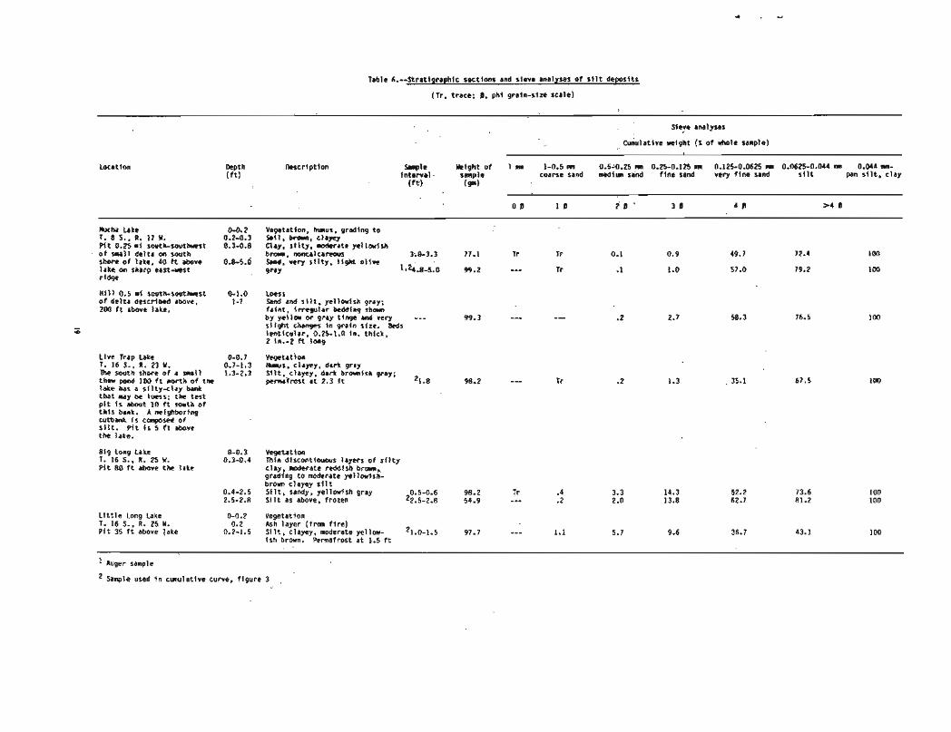
Samples taken near Mucha Lake (T. 8 S., R. 17 W.) along the northwest side of the Bearpaw Mountkin area consist of about 50 percent very fine sand and nearly equal parts of coarse silt and fine-silt-and-clay. The surface northwest of Castle Rocks is underlain by more variable seditnents; very fine sand dominates two samples from Big Long Lake (T. 16 S., R. 25 w.), but the one from nearby Little Long Lake has 56.9 percent fine silt and clay. Both of these lakes are near the northwest edge of the terrain; the sample from Live Trap Lake, near the northeast edge, has about one third each of very fine sand, coarse silt, and fine silt and clay (details are given in table 6). Southwest of Castle Rocks, however, a ridge along the south side of Burnt Lake (T. 18 S., R. 26 W.) contains silty clay, indicating that the silt did not extend into the wind shadow of the hills. Permafrost, lacking at Mucha Lake, was present a t depths of 2D to 30 in. in the Castle Rocks area, and lakes are mostly the smaller, more numerous, and steeper walled thaw lakes typical of thermokarst terrain.
The only other locality where similar sediments were penetrated by pit or auger is the peninsula between the Beaverlog Lakes (T. 11 S., R. 22 W.), where 6.5 f t of clayey silt overlies sand (see table 3). Chapman and Yeend (1981, p. B30) report "silt more than 5 f t thick conceals bedrock on the lower hills between the Cosna and Kantishna Rivers."
Loess
All of the dunes visited (except the blowout at Dune ~ a k e ) were covered with buff-colored, silty and clayey, noncalcareous, unconsolidated loess ranging from one inch to nearly 2 f t in thickness. No bedding was seen, and although the deposits are commonly too thin to show the vertical cleavage typical of loess, they are coherent enough to form vertical or slightly overhanging faces in cutbank exposures. The upper inch or so is commonly darkened by the addition of a little humus and the incipient soil profile. Roots of living plants penetrate the loess, and dark-brown root-shaped mark- ings are evidence of plants now dead. In many cases, forest fires have left a residue of ash between the loess and the present vegetation. Except for these minor changes, the materia seems little altered, and no other weathering is apparent.
The loess also occurs on bedrock-1 f t or less coats the western slopes of the Roosevelt Hills and the upper two thirds of Sevenmile Bill (T. 1 2 S., R. 23 W.). Apparently the only surfaces that lack loess are very recent flood plains and lake shores. The available measurements suggest that this blanket deposit is thickest in the northeast, thinning gradually and irregularly to the west and south.
South of the dune field, loess occupies the slightly higher ground along the northwest slope of the Kantishna Hill3, an area of typical thermokarst topography. It contains many deep-set ponds whose vertical banks are commonly sealed by undercut and overhanging mats of roots and other vegetation. Samples from exposures s t several lakes, ranging from lake 581 (at the boundary of T. 8 and 9 S., R. 15 W.) to Lonely Lake, (T. 16 S., R. 20 W.), are all typical loess; details are given in table 7. An alluvial fan of the Toklat River, its apex located where the river emerges from the Kantishna Hills, forms the eastern boundary of this widespread deposit. The loess is also interrupted by alluvial fans of Moose Greek and the McKinley River to the west. Jn each case, the fan is lower in elevation than the adjacent loess.
Southwest of the silt &posit around Castle Rocks, the silty clay at Burnt Lake may be loess, but it is gray, water- soaked, and close to permafrost and is probably muck.
Other exposures large enough to be seen from a small airplane have the vertical banks, color, and presence of swallow nest holm typical of loess. Such holes are present in various places outside the dune field; some are listed in table 7.
ANCIENT ENVIRQN MENIS
Pre-dune conditions
In the central Kantishna River valley and probably elsewhere, the dun@ were deposited on alluvium derived from the Alaska Range. Along the lower Kantishna River the contact between gravel and alluvial sand seems to dip a bit more steeply northward than the present grade of the river; the alluvium in thb vicinity may be a continuation of an inactive alluvial fan that extends north from the point where the Toklat River emerges from the Kantishna Hills. The best exposure of this underlying material is located at site I; here the sediments become finer upward in the section. Organic material is rare, but a small carbonaceous parting in the upper part of the cutbank indicates that vegetation was near enough to be washed in, and Estella Leopold has identified a probable tundra assemblage (85 percent Betula 2. probably dwarf birch) and abundant algae, suggesting a productive lake (written commun., 1972). The willow Salix cf. S. lauca was identified fmm Kantishna River site 3 ~ t a b l a f ~ i b e r t Nelson. A 1.2-in. layer of olive-gray clay at site 7 A may mark the lacation of a pond or backwater, and a few sand- size fragments of mollusks and one of an insect were found in the overlying massive sand (see table 4). These bits of data hint at enough water to support sufficient vegetation to keep the silty, sandy material in place.
Source of sand
When a change in climate resulted in diminishing vegetation, the winds began to move sand southwest across the alluvial deposit. The sand, brought down to the Tanana River by the ancestral Nenana, Kantishna, and other streams, overwhelmed any remaining vegetation and built the massive dunes that lie immediately to the southwest. This was especially true near the northwest-flowing stretches of the Tanana River, indicating that the river was in much the same position as it is now. Farther to the southwest, a diminishing sand supply permitted vegetation to anchor the dunes, resulting in the parabolic and longitudinal dune forms typical of areas that have discontinuous plant cover (Melton, 1940; McKee, 1979).
It seems significant that the dune field does not extend eastward up the Tanana River beyond its junction with the Nenana River. The Nenana River occupies the only large glaciated valley in the Alaska Range between the Delta River valley, 100 m i to the east, and the Muldrow-Foraker complex, a similar distance to the west. Its location relative to the dune field suggests that it was the source of sand for the eastern area. The Kantishna River and its glacially fed tributarie furnished additional sediment to the central area and the Northwestern Tract. The massive deposits west of the lower Kantishna suggest that this river too, "maintained its course during the time of dune activity" (written commun., D. M. Hopkins, 1983).
The northwestern boundary of the dune field strikes west-southwest (downwind) from the junction of the Tanana and Yukon Rivers. Two factors may have caused this relationship: (1) the Yukon River is a large stream and is a few hundred miles distant from pmsible glacier-fed tributaries, so its flow of water may have increased enough below the junction to carry remaining sand on downstream; (2) downstream from this junction the Yukon River h u p the southern base of a range of hills that could have deflected the northeast wind from the river and its sandbars.
The southwestern dune area is separated from the other parts of the field by a few miles of sandless terrain. The glaciers draining the Mount McKinley region (the ancestral
Muldrow, Peters, Foraker, and Straightaway Glaciers) could well be the source of sand for this comparatively small dune area, via the equivalents of the present McKinley, Foraker, and IIerron Rivers. This relatively close source could account for the comparatively coarse grain size in many of these dunes, and for the large size of the dunes compared to the dunes at the southwest end of the central area.
Climate during dune deposition
No direct evidence exists as yet to show whether the formation of the dune field was accompanied by warmer or colder climates. A warming climate, by destroying permafrost that now underlies much of the region, would destroy the swamps, muskeg, and possibly the spruce forests, which are more sensitive to aridity than to cold. It would also be associated with retreating glaciers, which would presumably increase the discharge of both water and sediments into glacial streams. A colder climate, especially if accompanied by the emergence of the Bering land bridge, would probably cause an increase in wind from the northeast (see below). It would also cause a decrease in stream flow and, hence, less alluvium to supply sand; a probable decrease in vegetation, however, would permit sand to blow. In either case, aridity and a large supply of loose sand were undoubtedly present.
If the vegetative and loess cover now anchoring the sand were removed, the present wind regime would probably be adequate to build a similar dune field. Alaska weather is now largely determined by low pressure systems moving from the northwest Pacific Ocean and by high pressure systems from northeastern Siberia. In summer the lows, which have counter-clockwise winds, tend to move north through the Bering Sea and bring wet southwesterlies to central Alaska. In winter the lows are more likely to move east, south of the Alaska Peninsula, bringing precipitation to southern Alaska and easterlies, dried by crossing the Alaska Range, to the dune-field region. The summer pattern of the highs parallels the Arctic coast far to the north; in winter the highs move eastward across northern Alaska, and their clockwise winds bring cold, dry northeast winds that often blow more than 20 mi per hour and occasionally reach 60 mi per hour. These patterns would be accentuated by the presence of a continuous land mass across the present northern Bering Sea.
Sediment still is blown from sand bars on the Tanana River near Old Minto (T. 1 N., R. 8 W. and designated as Minto on the map sheet) to as far as 50 mi to the southwest, when the wind is strong. At Lake Minchumina, the wind first strips several inches of snow from the sandy silt of the Foraker delta flat and then blows the sediment, a t altitudes as much as 60 or more ft above the surface, to a hill a mile or more away. It has deposited as much as 2 in. there in a single wind storm, killing the underlying low vegetation. Sample + (fig. 3), for instance, was blown in suspension for more than 0.25 mi and then deposited on the deck of a boat as a 0.5-in. layer interbedded with snow, the result of alternating wind and snowfall. This sediment is slightly coarser than samples from the silty deposits near Bearpaw Mountain and Castle Rocks, but finer than the dune sand. By contrast, southwest winds are usually accompanied by rain or snow and generally do not cause either snow to drift or sand and silt to blow appreciably, although they are responsible for the small blowout dunes at Dune Lake and near Spirit Lake (T. 1 4 S., R. 28 W.). Winds from other quadrants are uncommon and usually not strong.
Finer material, probably carried as a suspension load, was dropped as the northeast win& rose over the isolated hills and was banked against the northeast slopes of Bearpaw Mountain and Castle Rocks, the former downwind from the eastern area of the dunes and the latter downwind from the southwestern area. Similar silty material rising above the dunes in the central area was probably deposited on the eastern flanks of the Kuskokwim Mountains to form the colluvium and silt identified on many lower slopes by Chapman, Yeend, and Patton (1975) and Chapman and Yeend (1981). Any silt blowing above the dunes of the Northwestern Tract would presumably have been dropped in the wide Nowitna River flood plain or perhaps carrled to the hills
several miles west of the Nowitna River. Like the dunes, the few silt-deposit samples are lacking in organic material.
Postdune changes
Another change, either in climate or in quantity of available sand, must have occurred because sand movement ceased comparatively abruptly, and the dunes and most other exposed surfaces were blanketed by loess. That the loess also blew from the northeast is suggested by the irregular thinning from northeast to southwest across the dune field. Small steep gullies, typical of loess deposits, are present on the east slopes of hills near Lake Minchumina, but are lacking on west-facing slopes. Loess deposition is probably still in progress, although at a much slower pace than in the past. A cloud of dust-future loess-that rose to a helght of 5,000 f t over the country between Minchumina, Tanana, and Nenana w a s observed in April 1965, an unusual but not unique event that undoubtedly resembled loess clouds of the past. Because single loess deposits were probably thin, they, in contrast to the heavier silt and sand deposits, may not have damaged or killed the underlying vegetation. Once deposited, the loess is more coherent than sand or silt; when frozen, it is rock hard even on dune crests, whereas the sand is loose and easily moved at the coldest temperatures.
AGE
Radiocarbon dating
The dune field cannot be dated directly because no radiocarbon dates are available that come with certainty from material within the dune deposits. However, three dates are probably relevant to the dunes. One sample, which has a date of 20,240 2 460 years B.P., is from a lake-shore deposit about 8 ft above the present Lake Minchumina, and the other two samples are from cutbanks of the Kantishna River. Of the latter, one sample (IJ, USGS-1489) dates 8 small carbonaceous parting in alluvial deposits at site 1 (point j, table 5) as 19,850 t 150 years B.P. This site is 12 mi south- west of the nearest large group of dunes in the eastern area and about 10 mi southeast of the nearest dunes in the central area. The depcsits appear to be part of the alluvial surface on which the dunes in the eastern area were deposited. The third date, from sample 6OAWrl4 (1-129271, is more than 40,000 years B.P. It came from site 4, a cutbank about 80 ft high and 1 mi long that intersects the edge of the central area of the dune field. Florence R. Weber, who collected the sample, described it as "reddish stained wood which appears to be in place in humus filled layer 20 ft above water level ...- the lowest 20 f t of the cut is quite full of humus which has a brownish tan color." (F. R. Weber, written commun., 1960). Twenty-one years later the south half of the site 4 bluff was covered with slumped vegetation, and the north half exposed only sandy and silty sediments (see table 2) and no organic- rich beds were visible. Therefore, the specific relationship of the sample to the dune sands is uncertain, although it is reasonable to asume that it predates them.
The dunes and the underlying alluvium as it is exposed In the Kantishna River banks are not cemented or consolidated. Drainage in the dune field is poorly developed, and streams and lakes circumnavigate or parallel the ridges. Dune ends protrude into several lakes, and dune sides form many lake shores, but little erosion of dune forms is visible. Their slopes approach the angle of repose of sand, and the lower slopes end abruptly at the junction with the flat terrain, Nevertheless, streams like the Chitanana, Zitziana, Kantishna, and Foraker have cut meander scars in the dunes, leaving sharply scalloped bluffs edging the flood plains5 alluvial fan distributaries of streams such as the McKinley River have left uneroded patches of dune-covered higher ground here and there (such as the one in T. 13 S., R. 21 W.).
The superposition of parabolic and longitudinal dunes on the large dune ridges in the east half of the Northwest Tract
and the north half of the central area implies a changing environment, but not necessarily two separate episodes of dune building. The nearly unaltered topography described in the paragraph above applies to dune-covered terrain whether massive dune ridges are present or not; the change in size and shape could be the result of decreasing sand supply and increasing vegetation.
Relation to former lakes
Two former lakes may have been confined by the dunes. One is represented by lake-bed deposits in the Chitanana River valley just west of Redlands Lake, and the other is represented by the present Lake Minchumina.
The lake deposits near Redlands Lake are about 200 f t lower in elevation than the dunes that border them to the north. The present Chitanana River drains the lake beds through a narrow valley that is cut between dunes and bedrock in T. 1 S., R. 22 W. and thence between two areas of dunes to the Tanana River valley. The Chitanana changes course from north-northeastward to east-northeast in doing so, which suggesb that the dunes may have blocked its original course and caused a lake to form. This was later drained when another outlet was found. Unfortunately, no present means exist to date these lake-bed deposits.
Ancestral Lake Minchumina, on the other hand, laid down a beach deposit containing charcoal fragments that have been given a radiocarbon date of 20,250 .L 460 years B.P. (Charles E. Holmes, written commun., 1982; sample WSU 2585). The deposit consists of 6 to 8 in. of rounded gravel 0.04 to 3 in. in diameter that is derived from the local dark- gray argillite. This is overlain by 3 to 5 in. of yellowish-gray clay and 0 to 2 in. of dark reddish-brown organic material that contained the charcoal. The sequence rests on bedrock and is overlain by mlluvium composed mostly of loess and small angular fragments of bedrock. The deposit marks a lake level of 650 ft, 8 f t above the highest level of recent times, and may correspond in age to a "slightly more mesic intervalf1 in the otherwise cold and dry Duvanny Yar interval (Hopkins, 1982).
This high level, however, is lower than any part of the southwestern area of dunes. The ancestral Lake Minchumina probably occupied the flats between the present dune field and the Kuskokwim Mountains and may have extended around the northeast end of the dunes as well. The ancestral Foraker, McKinley, and Herron Rivers could have emptied into such a lake and deposited alluvium there. If the dunes in the southwestern area were fed from such a source, dunes and lake could have been contemporaneous. No indications of a shoreline have been found between the dunes and the ancestral lake. In the lowland east of Lake Minchumina (northeast part of T. 12 S. and southeast part of T. 11 S., R. 21 W.), two small patches of northeast-trending dune-like ridges occur below the 650-ft contour (from the 1:63,360- scale McKinley D-4 quadrangle) close to the lower Muddy River. They are 2.5 to 4 mi from the nearest parts of the dune field, but if they are a remnant of the dune field, and if the ancestral lake did extend that far southeast, they are presumably resting on the lake bed and hence postdate it.
Younger and older dunes
The similarities in dune shape and erosional features described above show that the dune field is mainly of one age. However, there are three small groups of north-striking dunes that may be younger than the rest of the field. Two of them are located on the west side of the Kantishna River on remnanb of river terraca that are about 30 ft above the flood plain, but about 100 ft below the dunes (T. 7 and 8 S., R, 16 W., and T. 4 S., R. 13 W.). The third group occupies a similar position between the Nenana River and the edge of the eastern area of dunes (T. 5 S., R. 10 W.). Sediments underlying the northern group near the Kantishna River are described in table 4.
An older generation of dunes may be represented by topography that has a vaguely northeast orientation of swales
west of Lake Minchumina. Similar terrain lies south of the dunes in T. 8 S., R. 15 W. These have not been visited on the ground, and the nature of the surficial deposits is not known.
Conclusions
Dune fields that have comparable topographic expression elsewhere in Alaska have been active during the late Wisconsin glacial interval (Fernald, 1960, 1964; PQw~' , 1975; Carter, 1981; Hopkins, 1982). Although the central Alaska dunes may have been emplaced earlier, it is reasonable to suppose they were a t least reworked at approx- imately the same time, when "the seasonal round of weather in periglacial Beringia consisted of short summers, warmer and drier than at present, and long winters, evidently colder but with snow cover thinner that at present" (Hopkins, 1979, p. 23). A change in cllmate beginning about 14,000 years age (Ager, 1975) brought increasing vegetation and, presumably, an end to major dune deposition in this region.
AGRICULTURE
Parts of T. 4 S., R. 10 and 11 W. west of Nenana have recently been surveyed for development as an agricultural area. This acreage is part of the eastern area of the dune field; it is underlain by "Nenana silt loam1', which is a shallow, well-drained soil, although increasing amounts of "Taklanika loamy fine sandtf have developed on dune ridges toward the west (Forbush and others, 1980). The presence of dunes suggests that any major disturbance of the vegetation and topsoil could easily result in blowing sand, rapid deflation, and deposition of sand downwind.
REFERENCES CITED
Ager, Thomas A., 1975, Late Quaternary environmental history of the Tanana Valley, Alaska: Institute of Polar Studies Report no. 54, Ohio State University Research Foundation, 117 p.
Carter, L. D., 1981, Middle Wisconsinan through Holocene climate in the Ikpfkpuk River region, Alaska: Institute of Arctic and Alpine Research, Tenth Arctic Workshop, Boulder, Colorado, p. 5-9.
Chapman, R. M., Yeend, W. E., and Patton, W. W., dr., 1975, Preliminary reconnaissance geologic map of the western half of the Kantishna River quadrangle, Alaska: U.S. Geological Survey Open-File Report 75-351.
Chapman, R. M., and Yeend, W, E,, 1981, Geologiml reconnaissance of the east half of Kantishna River quadrangle and adjacent areas, in Albert, N. R. D., and Hudson, Travis, eds., The ~ n x e d States Geological Survey in Alaska: Accomplishments durlng 1979: U.S. Geological Survey Circular 823-B, p. 830-B32.
Fernald, Arthur T., 1960, Geomorphology of the upper Kuskokwim region, Alaska: U.S. Geological Survey Bulletin 1071-G, p. 191-279.
- 1964, Surficial geology of the central Kobuk River valley, northwestern Alaska: U.S. Geological Survey Bulletin 1181-K, 31 p.
Fwbush, C . E., Koepke, B. E., and Schoephorster, D. B., 1980, Soil survey of Totchaket area, Alaska: U.S. Department of Agriculture Soil Conservation Service with University of Alaska Agricultural Experiment Station, 68 p.
Gcddard, E. N., chairman, 1948, Rock-color chart: Washington, D.C., National Research Council.
Hopkins, David M., 1979, Landscape and climate of Beringia during late Pleistocene and Holocene time, & Laughlin, W. S., and Harper, A. B., eds., The First Americans: origins, affinities, and adaptations: Gustav Fischer, New York, p, 15-41.
- 1982, Aspects of the paleogeography of Beringia during the late Pleistocene, Hopkins, D. M., Mathews, J. V., Jr., Schweger, C. E., and Young, S. B., Paleoecology of Beringia: Academia Press, New York, p. 3-28.
McKee, Edwin D., 1979, Sedimentary structures in dunes, with two sections on the Lagoa dune field, Brazil, by Joao J. Bigarella, & McKee, E. D., ed., A study of global sand seas: U.S. Geological Survey Professional Paper 1052, p. 83-136.
Melton, Frank A., 1940, A tentative classificatjon of sand dunes: Its application to dune history in the southern High Plains: Journal of Geology, vol. 48, no. 2, p. 118- 174.
P6w6, T. L., Wahrhafti~, Clyde, and Weber, F. R., 1966, Geologic map of the ~a i rbanks quadrangle, Alaska: U.S. Geological Survey Miscellaneous Geological Investigations Map 1-455.
P6w6, T. L., 1975, Quaternary Geology of Alaska: U.S. Geological Survey Professional Paper 835, 145 p.
aldlues ~ a 6 n y
E a~n6!4 'ahJn3 ah!leInunY U L pasn a l dmt j I
pugs L%l!s spaq X!JIPU PUOS 3 5 ~ 9 0 3 e u! u!41 auos ! J a h ! ~ a*oqe 14 11-01 p u t j Y l ~ a q 3 pue z-uenb papunoJ
l u a l u 6 ~ ~ 4 qsn ( iu!eauo3 - t (a 40 r l ( & ~ e ~ & ~ d pasod 'dahyJ aAoqe 14 81 lnoqe ' 1 3 ~ 4 1 'u! O'E-E'O -uo> " u l 2-1 ILISOW ' J a w
spaq d ~ ~ n 3 l l u a l u! pues pappaqssod3 au!j 3 '-wekp u! 'u! c-b-0 aJe salqqad Jah!J aAoqe 14 02 WJJ PUS 3 !Lana( Jahw aAaqe 14 8 se
( u o s u 'g q 6 ~ y se dnmo puer asJeo3 h ppa4!1~ap~) G F i E -7 -42 . d ~ x ! [ e j 40 41?* PaPPqJa3UL l a h e ~ 6
s ~ u a u d e ~ a )pat ah!^ aAoqe 2.4 ob WJJ p u s u 40 spaq ~ ~ [ n > ! l u a i u!q1 ' d w p aJOU JO 31 Z PUP
T a n a r a a n r 5 S S O J ~ P 14 E - o lnoae salou La
MI ZE'Ci6 L9'16 28'11 69'42 65'6 IE'2 28' --- --- 6E'ZZZ : V
3saq ldOu UOJ) &In E.0 4 s - P o q e spaq pasodxa SPU, :IS* a q ~ 02 ahem02
6uot w I 14 USI anoqe.S+ 44qq,paidues
n b1 'L! -5 5 .l s41nL8 dah!8 IPL lO l
I r-z o c I S-E g -E w 5-2 a z 5-1 s I d 5-0 a o
be13 ' x l & s ued 11!s WQS w l l h a * pups a u l d puos n r p w pues asdw:, - 4 ~ bt0-0 CVO'U-5290'0 U SZ90'0-SZ1'0 w UT'O-SZ'U Ilu SZ'O-5.0 ulu 5-0-1 urr I aldues 1 ~ r 4 a a u l
40 w 6 m a ~ d w
Table 2.--Stratigraphic sect ions and s l eve analyses o f sand froa dunes f n t h e cen t ra l area
(Tr , trace; $, ph l gra fn-s tze sca le)
Sseve analyses
E w l a t i v e Yelght (a of h o l e sample)
Depth Descr ip t$on W p t e i n t e r v a l w i g h t of 1 m 1-0.5 ~.r 0.5-0.25 m 0.25-0.125 a 0.125-0.0625 n u 0.a625-0.044 m 0.044 m- ( f t ) t f t ) s a p l e coarre sand nedim sand f l n e s a n d v e r y f i ~ e s a n d s i l t pan s i l t , c l a y
(m)
0 0 0.5B 1 8 1.51 2 f i 2.511 3 8 3.56 4 0 =-a 1
Kindanina Lake 0-0.2 Uegetatlcm 1. 2 5.. R. 15 Y. 0.2-1.8 C t a j , s i l t y . moderate y e T l a l s h P 1 t 50 ft above l ake b r m , un i form
1.8-5.0 Sand t h a t has s r m k s o f M d i u a t o coarse sand and r a r e granules; I l g h t ye l l ow fsh gray 2.3-2.7 98.6 1.1
i 3 . f 3.5 49.5 3.4 4.5-5.0 100.5 1.4
l k sg i za Lake 0-0.2 Yegetatton, 7. 2 S.. R. 13 Y. 0.2-1.8 Clay, s i l t y . d e r a t e y e l l w - P t t 50 ft abave l ake i s h b r m . v n l f o r n
1.8-5.0 Sand, l f g h t y e l l m f s h gray, ?h3-2.5 100.8 --- .1 6.7 uniform. massfve 4.5-5.0 119.8 --- .1 13.2
FEET Kantishna River
To 04 bt-ff
Btuff. 0.5 mi tong. 2 m ft high. Upper- ms-f beds d l p as much as loo south; h o r l - zanta l contact w i t h R r v r r rrwl
underlying beds which dip So s o i t h
;; t o w e r p a r t b a d l y slmped; has SIMI low holes (see s i t e 3. t a b l e 1). ho r i zon ta l bedding(?)
Wilderness Lake 1. 4 S., 1. 18 Y. P i t 35 ft above l ake
East Twin Lake T. 6 5.. R. 16 Y. 30 ft above lake
Kantishna River s i t e 4 T, 6 5.. R. 15 Y.
Locat ion C, 8 f t above r f v e r A l e ve l , shors interbedded s i l t and ve ry f i n e sand w i t h a fen coarser 6 lenses; beds 0.25 t o 0.5 in. t h i ck , l e n t i c u l a r . Sare sand l aye rs y e l l w - i s h gray; clayey s i l t i s moderate o l i v e b r m o r l i g h t t o mediw gray. Patchy carbonaceous pa r t i ngs
D-0.1 Uegetatian 0.1-0.5 Clay, s t l t y , moderate reddtsh
brown; sharp bu t i r r e g u l a r base 0.1-0.4 ft b e l a r t o p o f bed
0.5-0.9 Clay, s i l t y . 0.1-0.1 ft t h l c k , has sharp contacts above and b e l m .
0.9-5.0 Sand. l i g h t y e l l w I s h gray. 1.2 uniform, massive l4.5-5.0
0-0.2 Vegetat ion 0.2-2.0 Clay, s i l t y , ye l l ow i sh gray, has
l r r e g u l a r s t reaks of moderate redd i sh b r m near top. S i l t i e r toward base
2.0-5.0 Sand, s l i g h t l g darker than 2.2-2.8 ove r l y i ng c l ay 1.24.5-5.0
Southern p a r t o f b i u f f i s vegetated b u t seam t o have ho r i zon ta l bedding. Ib samples *ere taken
a Hor izonta l bedding I n sand b Contact sharp !&ere exposed c S i l t i e r , grayer than ove r l y i ng sand d Sand e S i l t v sand. orav. t h i n . contlnuous beds
g Drganic raaterlal h S i l t ? i Coarser than h- approximately hor izonta l b e d d i n g 2-4 in. beds of sand j Hor izonta l , s l f g h t l y wavy beds 0.5-2 i n . t h i c k ; ;and k Beds hor izonta l o r w i t h s l l g h t d i p t o n o r t h and 0.5-2 i n . t h i c k
f ye1 t i u i s h jGe - ' i o medium-grained sand ; bedding p a r a l l e l s gray beds
Table 3.--Stratipraphic section and sleve analyses of sand fra dunes i n the s o u t h r s t area
{Tr. trace; 8. pht g r a i n - s i n scale)
l e v e analyses
C u n r l l r l n r i g h t (1 o f xkole sample)
Oepth m c r t p t f c n *le Y i g h t o f I mr 1-4.5 n 0.5-0.25 m 0.25-0.125 m 0.125-0.M25 a 0 . ~ 2 5 - 0 . 0 4 4 ra 0.044 m- t f t l In terva l s q l e coarse sand w d l u sand f lne rlnd very f l ne sand s l l t pan s i l t . c?ay
( f t l (*I
0 0 1 8 2 8 3 1 4 8 2 4 6
Location
Wver laJ lakes
m s hn, tiW gray, clayey ( f r a f i r e ) S l l t , clayey ( L a r s ) . dar t y e H a i s h orangr. nonca lcar rwr (paft of 1011 profile) S l l t as above. y e l l w i s h gray S l l t . clayey. mttled mdiu l l @ t gray and moderate y e l l a l s h b m n ; browner I n top 6 In.
p i t 00 east side Y s t BEaverlog Lake 15 ft h v e lake
b u s wl th ash layer a t base stlt.'clayey ( lorss), y e l l w i s h pray. m a l c i n o u s 511t. clayey. r o t t l e d m d l u I l g k t gray and h r a t e y r l l c d s h b r m
P l t on s ~ u t h r s t slde o f East h v e r h g Lake. 23 f t above f l a t s ( f n grmp o f small p l t r dug i n the 1920'sI
b u s 911, dusky b m a t top g r d l n g t o dark y r l l o x l s h bran. Contact d t h u n d r r l q l n g clayey s l l t 1s sharp. s i i w l y I r r egu la r S i l t , clayey. grayish yell-. S l ight w t l l n g d t h dark ye l lau lsh orang+ near t o p Sand, s l l t y . y e l l a l s h gray, mott led wl th moderate y e l l w f s h brwn. l ~ ~ 5 . 2 S l i gh t l y coarser r l t h depth l6.8-7.3
Stl, dark yel lowish brmm ~ w r s t o bottm; s l l g k l y coarser a t base
~ u g e r hole a t corner o f r ldge southuest of Bervrr log Lake, 25 R above f l a t s
Clay, very s l i g h t l y s11ty. graytrh p 1 1 a S i l t . c l apy , y e l l a r l s h gray, slightly mott led 91th y e l l w l s h bmm Sand, very Fine gralned. y e f l w l s h gray
PI t 51 ft southeast and 25 ft below a w r ho le
B l l l k r g Lake 0-0.1 1. 12 s., 11. n M. 0.1-0.4 P i t +n dune formlng 0.44.0
vegetation I l t , c1eyey, noderate y e l l w i s h brow sand, y e l l a f s h gray
peninsula I n north: uest par t o f lake
&s l ing Late 0-0.1 ~ . i z s . , ~ . n w . 0.1-0.2 P i t Is ft above lake 0.2-0.3
Vegetatlm 5011. wdlm dark b r a n Clay, s l l t y . e e r a t e reddlsh braun ( loess) Clay, s l l t y , moderate y e l l m l s h brmn ( loess) Sand. ye l l a r i sh gray
Vegetat Ion Clay, s l l ty . &rate y e l l w i s h b r a n S t l t . clayey. r H g h t l y grayer' than ahve. Grades u l t h i n an 1 x h to Sand, moderate y e l l a f s h brmm, but grayer than s f l t
- -. . - - - - - 1. 13 S., R. 23 Y. 013-0;s P f t 25 f t above lake, 0.6-1.3 i n dune a t s o u t h s t shore o f lake 1.3-9.1 100
too 100
4.1 Horlzontat 0.25 i n layer of very coarse sand 1 N . 9 6.6 36.4
4.1-4.3 Sand as a t 1.3-4.0 ft 24.1-4.3 100.9 .3 1.9
Corner Lake 0-0.7 Yegetatlon T. 14 5.. R. 22 Y. 0.7-0.8 Sand, clayey. s l l t y , very fire t o P l t 30 ft above lake. f i ne gralned, moderate reddish b r m n on kno l l 1 W f t 0.8-1.3 Sand. moderate yel lowish brom 1 rauare 1.3-2.5 Clay. sandy. s i l t r . noderate vel lmrlsh -.- -
broini - - - - 2.0-2.7 ~and I l g h t y e l l m gray 2.3 l(XI.1 .I 1.7
2.7 sandsas above. frozen
Table 3.--Strat igraphic sec t ion and s ieve analyses o f sand from dunes I n t h e southrest area--Continued
Sieve analyses
Cumulative weight (% o f whole sample)
Locat ion Fampl e M i g h t o f I mn 1-0.5 mn 0.5-0.25 m 0.25-0.125 mn 0.125-0.0625 nm 0.M25-0.044 rn 0.044 m- i n t e r v a l sample coarse sand med im sand f i n e sand very f i n e sand s i l t pan s i l t , c l a y
( f t l (ml
0 B 1 0 I !9 3 0 4 8 > d l
Foraker Pond 0-0.2 Vegetation, s m e blackened by f i r e --- 100.7 0.3 3.5 21.4 82.7 97.8 99.0 100 T. 14 S., R. 24 W. 0.2-0.4 Clay, very s l i g h t l y s i l t y , moderate Lake-bo t tm sediment brown, noncalcareous; sharp contact from 10 ft i n northuest w i t h o f southeast corner 0.4-0.6 Clay, very s i l ty. moderate ye1 l o u i s h o f lake. P i t 0.25 mi brown east o f pond 0.6-1.2 Sand, ye l low ish gray; granule layer 0.6-0.9 100.1 .3 .4 10.3 77.8 99.8 99.9 IDD
a t O.P f t , , 2 ~ . - ~ . ~ 99.6 5.7 6.7 16.1 69.4 98.9 99.1 100 1.2-4.2 Sand, ye l low ish gray. no granules, 3.9-1.2 100.0 .2 .6 8.8 68.2 99.0 91.4 1WJ
uniform
Foraker River, 0-1.0 Vegetat ion T. 14 S., R. 21 W. 1.0-2.0 Ihrck, dark g ray ish brown, very Pnrthank nn wqt s ide s l i o h t l ~ s i l t " . . . - . . . . . . . . - - - . , - ., o f r i v e r 0.25 m i east 2.0-2.1 Sand, very f i n e grained, ye l low stalned. o f Foraker Pond: top Sharp contact w i t h muck 5 f t o f c u t exposed 2.1-5.0 Sand r n lenses 118-2 in . t h i c k , 2 in . 2.5 26.5 31.0 77.9
t o 5 ft long. l o crossbedding 3.0-3.5 99.6 2 2.5
Cutbank on uest bank o f r i v e r ; 0.25 mi n o r t h o f cutbank descr ibed above
N
15 ft above r i v e r
a F l a t - l y i n g sand. s i l t . c lay : has t r e e branches
Doghouse Lake T. 14 S., R. 25 W . ( p i t 50 ft above lake)
0-0.2 Vegetat ion and humus 0.2-0.4 flurried layer, sand and ash 0.4-0.8 Sand, l i g h t b r m n a t top, grading t o
moderate y e l l w i s h brown a t base 0.4-0.8 0.8-1.7 Sand, g ray ish y e l l o v 1.2-4.7 Sand as above, un i fonn Il.2-1.5
ls24.0-4.7
Lake Snohmish 7. 13 S., R. 26 Y. ( p i t 40 ft above lake)
0-0.7 Vegetat ion 0.7-1.2 Clay, s i l t y , moderate y e l l o w i s h
b r o w , g rad ing t o 1.2-5.0 Sand ( s i l t and a l i t t ? e c l a y i n upper 11.6-1.8
1 f t l , m o t t l e d medim yeTlmrish gray 3.0-3.5 14.5-5.0
20 ft above lake , on slope below p i t --- I r r e g u l a r , hor izon ta l , l e n t i c u l a r
bedding. F iner g ra ined s t r a t a s l i g h t l y grayer o r ye l lower than others
Cranberry Lake T. 14 S., R. 26 U. ( p i t I 0 ft above lake)
0-0.3 Vegetat ion 0.3-1.0 Sand, l i g h t brown, mot t led w i t h c layey 0.5-0.7
sand. moderate ve l low ish brown. grading t o -
1.0-1.7 Sand, moderate y e l l o w i s h brown, len- t i c u l a r . a ~ ~ a r e n t southward d i ~ 1.3-1.5
1.7-1.8 Sand, very ' f i n e grained, s i l t g ' 1.8-3.5 S a n d , f i n e t o m e d i u n 3.5-4.5 Sand, f i n e t o coarse l ~ ~ 3 . 8 - 4 . 5
Beaver Lake 1. 15 S., R. 26 U. P i t 10 ft above lake: cutbank below p i t i s sand t o w a t e r ' s edge
D-0.2 vegetat ion 0.2-0.4 Sand, clayey, dark g ray ish brown ( s o i l ) B.4-0.8 Sand. c layey , moderate yel lowish-brown 0.8-1.2 Sand, ye l low ish gray 1.0-1.2
-56u!%.red snoa3euoqJe2 K~$46! 1s q l p 11+5 J p u e ~ e
-a a3PJJal 11-42 a41
uo saunp r l lnos- t~$~ou aq? j o auo sjaas 5 -Jaw! lueq ln? a q l leu3 s~sa56ns adeys
sa! :%sanqinor-isan sax!JIs L aJ!s .L a l p W J ~ (uea~ l sdn ) qwos rlu 42-0 s! V L a>!s
! ) ) n l q al6u!s e uo aJe suo113as an3 asaq1 'M E l ' 8 " S t '1
W L PUP L salks Jan& eUUS!lUPY
7 7
J,~I~'JO l i e d p a ~ l l o 6 s!G 'aauel -S!P e u o ~ j - paz~u f i oaa~ punoJ6 uazoJ4 ou pup pasodxa sen a>! ON ' L ~ k n 6 qasa uLedp
Ex d
OLE (s. U33
1333
N 5
KJan 'uo&1ela6ah pue s a o o ~ 40 'leu e 4 hunqdalo a n i aq3 pue ' le>!q~ah LlJeau a n
S L L P * C11n6 Jad4 '44nIq ar l l o w ! u or a w s pualxa 1e41 sa! I tn6 $deus-~alqo6 'aqr I
-are> 40 s a r ~ a s e 6u!Lelds!p daA!V euqsbauex aqx uo aua Kiuo a y l s! )$n lq s!q1
. L P J ~ JaqJep aJp ~IPJIS ~ [ r s Kppnlu aqa :qs!ml l ad aJe s ~ a L e l
lpues ay'l JO aw-j '111s 01 pues asdeol wor i 6utbu~d spaq 'u i -2 03 -42'0 deln3taual
qqrx 6ubleu~a3[e pues ahrrsetu aJe spaq le3 - U O Z ~ J O ~ aq l '3964-1 ausJ3xa ae !Flap aJow u! u n ~ y s pup 1 ~ 6 1 ~ 1e ured6erp u! e u o k l e m l J F ~
'dJ6-qs pue [FluOZ)Joq s+ SlJed J a m 1 pue ~ a d d n uaanlaq aaeaua3 aq3 !ah!sreu aJovl ~ e d Ja
-*a( a q i 'pppaq K ~ ( e a u a z & ~ ~ q s! adnsodxa yl 40 i r e d ~ a d d n a U 'pW UWOU l@ y6ru 1J +Or
'Pua uwos 1~ 4 6 4 14 OE pue p o l ru 5'0 44nta R E I 'V "S b -i
5 a1Ls
Table 5A. - -St ra t igraph ic s e c t i o n s o f cutbanks a l ong the Kant ishna R i v e r o u t s i d e o f t h e dune f i e l d
Loca t i on Desc r i p t i on
S i t e s 1 and 2 B l u f f about about 4n f t h igh, more t han 1 mi l ong 1. 9 S., R. 16 W.
475i F6EY A
--/--*::-::-. . - - :.. . - A - --
4352 - - 4352
1
S i S l l t y Yel low s ta i ned *-- Animal ho les a-d, f, h - See s i eve analyses Sd Sand o Orange .-... .. . -.Swal low-nest ho les h L e n t i c u l a r sand and s i l t Sy S i l t , b l ocky , l i g h t .=--=Horizontal bedding 4 Peat j Carbonaceous p a r t i n g
gray, and ye1 low ///LCurrent bedding Le L e n t i c u l a r :oP-;Gravel and sand
S i t e H T. 4 S . , H. 1 3 W.
S i t e 9 T. h S., R. 14 W.
S i t e 10 T. 6 S., R. 15 W.
S i t e 11 T. R S . , R. 16 W .
S i t e 17 T.10 5. . R. 17 W.
S i t e 13 T. 10 S., R. 18 11.
S i t e 14 T. 11 S., R. I 9 W.
I n t e r m i t t e n t bank, 10-15 ft h l yh, o f approx imate ly h o r i z o n t a l beds of s i l t y , sandy, ye1 lowish-gray sediments. Most ly covered. No samples taken
Bank i s 15 f Z h igh, 0.5 mi long. H o r i z o n t a l l y hedded s i l t y sand and sandy s i l t o v e r l i e In terbedded coarse sand and g rave l . Contact i s 7 ft above r i v e r a t no r t heas t end, 6 ft above i t a t t h e southwest end. The g rave l ranges fram granules t o 3- in . cobbles, bu t i s mos t l y 0.5-2 i n . i n d iameter ; i t becomes sma l l e r toward t h e t op ; some shows t o r r e n t i a l heddlny, bu t has soma h o r i z o n t a l sand beds. No samples. Gravel t o 1.5 ft above r i v e r i n l o w banks 0.6 mi downstream
Rank 8-12 ft h igh, 150 f t lony, sandy, y e l l o w i s h gray
Rank R-10 ft h igh, sandy, r ough l y h o r i z o n t a l beddiny. S i t e 1 1 A across r l v e r I s sandy, has more even bedding
Bedrock o v e r l a i n by up t o 30 f t in terbcdded Wbangular pebbles t o s t l t w i t h s i l t y c lay ; beds o f g rave l 3 t o 12 i n . t h i c k ; s i l t y c l a y 1 i n . t o 6 f t t h i c k makes up QO percent o f sec t i on . Clay and m a t r i x o f g rave l a r e ve ry l i g h t y e l l o w - i s h yray. Rcdding h o r i z o n t a l . Ye l lowish-yray c l ayey s i l t o v e r l i e s in terbedded g rave l and s i l t t o 100 ft above r i v e r l e v e l ; upper su r f ace r i s e s t n t h e n o r t h a t 2n percent grade. No samples
Small cutbanks. R ft h igh , 20-30 ft long ; h o r i z o n t a l beddiny, sandy
Cuthank, 50 f t long, 10 ft h igh. Po in t A i s h i n . above p n i n t R and marks t h e hase of h o r i z o n t a l l y bedded, f i n e - g ra i ned t o s i l t y sand. Po in t R 1s coa rse r sand (see s i eve a n a l y s i s below); ho th are l i g h t g ray i sh y e l l o w
Table 5R.--Sieve analyses o f samples frm cutbanks i n t a b l e 5.4
(0, ph i g r a i n - s i t e sca le )
Sieve analyses
Cumulat ive weight ( X of whole sample)
Sample Weight o f number sample 1 mm 1-0.5 mm 0.5-0.25 mm 0.25-0.175 mm 0.125-0.0625 mm 0.0625 mm-
(gm) coarse sand medium sand f i n e sand ve ry f i n e sand pan s i l t , c l a y
Table 6.--Strattgraphic sections 8nd sieve analyses of s f l t deposits
(h, trace; 9. phi graln-sire scale)
Steve analyses
~ k l a t i v e r i g h t t l of whole sample)
Location b p t h k c r i p t l o n ( f t l
S1.gle W i g h t of 1 la 1-0.5 an 0.5-0.25 nn 0.25-0.125 m 0.125-0.0625 n O.Mz5-0.044 m 0.014 m- f n t u v ~ l s m p l e coarse sand medim sand f i n e sand very fine sand s i l t pan s i l t , c lay
( I t )
--
h c h a Lake 0-0.2 Vegetatton, b u s . grading t o T. 8 S.. R. 17 W. 0.2-0.3 5011. b W , c + a p y P l t 0.25 a i s o u t h - s o u t k s t 0.3-0.8 C34y. sf l t y , mudcrate ye1 lowish of small del ta on south brown. noncalcarmus 3.8-3.3 77.1 shore o f lake. 40 f t above 0.8-5.0 Sand. very s f l t y , 1 igh t o l i v e lake on sharp east-west gray 1.24.8-5.0 99.2 rfdge
HI11 0.5 mi south-southwst 0-1.0 Loess of del ta described above. 1-7 Sand and st lt. y e l l o r l s h gray; 200 f t above late. fa int , i r regu la r bedding sham
by y e l l m or gray t lnge and very --- 99.3 --- --- - s l i g h t changes In grain size. Beds w lenticular. 0.25-1.0 In. thfck,
2 in.-2 ft long
LIve Trap Lake 0-0.7 Vegetation T. I6 5.. R. 23 Y. 0.7-1.3 m s , clayey, dark gray The south shore of a small 1.3-2.3 S f l t . clayey. dark bramish gray; t h a w pond 100 f t north o f the permafrost a t 2.3 f t ?1.8 lake bas a s i l t y - c l a y bank t h a t may be loess; the t e s t p l t f s about 10 ft south o f t h i s bank. A neighboring cutbank i s caposed o f s i l t . P i t i s 5 ft above the lake.
019 Long Lake 0-0.3 Vegetation T. 16 5.. R. 25 Y. 0.3-0.4 Thln discontinuous layers o f s l i t y P i t 80 f t above the lake clay, moderate reddish b r a ,
gradlng t o moderate yellowish- b r o m clayey s i l t
0.4-2.5 Ult. sandy, y e l l w i s h gray 20.5-0.6 M.2 Tr .4 2.5-2.8 S i l t as above, frozen 2.5-2.8 54.9 --- .2
L i t t l e Long Lake 0-0.2 vegetation T. 16 5.. R . 25 U. 0.2 Ash layer ( f r m f i r e ) P i t 35 f t above Jake 0.2-1.5 Si I t , clayey, moderate ye1 low- 21.0-1.5 97.7 --- 1.1 5.7 9.6 36.7 43.1 100
i s h b r m . Permafrost a t 1.5 ft
Auger sample
Sanpfe used f n c m l a t l ve curve, f igure 3
Table 7.--Loess d e ~ o s i t s i d e n t i f i e d south o f t h e dune f i e l d
(Loess i s present a t every dune-crest p i t , and t h e d e t a i l s , o f th ickness a t those l oca t i ons are shown i n t h e sect ions
descr ibed i n tab les 1-6)
Locat ion Depth (ft)
Descr ip t ion
-
Lake 581 Sec, 3, 4, and 34 T. 8 and 9 S., R. 15 W. P i t on peninsula on northwest s ide o f Jake
Kantishna River S i t e 12 T. 10 S., R. 17 W.
3.5 Loess, w i t h mica; s l i g h t l s i l t i e r than a t h i 1 1 527 (descr ibed below! ,
--- Nearly v e r t i c a l cutbank, 80 t o 100 f t high, about 300 ft long. Loess, l i g h t h u f f gray, no bedding, nunerous swbllow holes
H i l l 527 --- Loess on s ides and top, exposed i n two South o f Kantlshna River p i t s 2 ft deep Sec. 14, T. 10 S., R. 17 W.
Sandless Lake T. 11 S . , R m 16 W e
30- f t -h i gh bank
--- S i l t y c lay, medium l i g h t gray, no beddirrg, i r r e g u l a r v e r t i c a l f rac tu re . Contains modern p l a n t r oo t s and i s overhung by a 1- t o 2-in. mat of vegetat ion
Lake 1.25 m i east-southeast 0-0.2 Humus o f Diamond 0.2-1.5 Clay, s i l t y , b u f f , uniform, no bedding; Sec. 10, T. 12 S., R. 17 W. 1 oess P i t i n steep bank 5 f t above l ake l eve l
Lonely Lake 1.0 Roots and s o i l Sec. 16, T. 16 S., R. 20 W. 8.0 Loess, buf f , uniform, no bedding Bank, v e r t i c a l t o overhanging, on no r t h shore o f l a ke