36
MINGEOSIS EIS

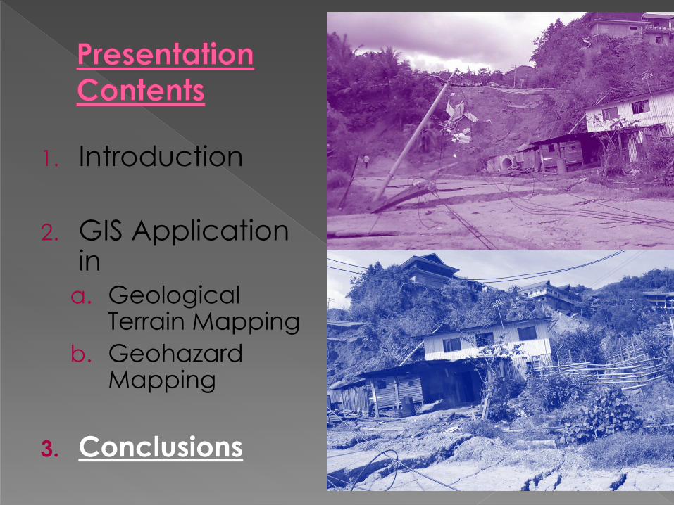
1. Introduction
2. GIS Application in
a. Geological Terrain Mapping
b. Geohazard Mapping
3. Conclusions

1. JMG as Custodian
for mineral and
geoscience data
& information
2. GIS has been
extensively and
effectively used to
manage and
analyse the large
amount of data
3. Geoscience data
include geological,
geochemical,
geophysical,
hydrogeological and
engineering
geological data

Relict os a landslide
4. These data together with other geospatial information such as topography, remote sensing, land-use and rainfall distribution data are being processed and analysed to generate various derivation of informative maps
5. The informative maps produced, such as groundwater potential, mineral potential, construction suitability and landslide hazard and risk maps, are very useful for land-use and development planning purposes

6. This paper highlights some examples where GIS has been utilized in managing and processing geoscience data, particularly for geohazard mapping
Zen Garden
SK Pekan Kundasang
Mount
Kinabalu
Heritage
Resort &
SPA

MINGEOSIS

MINGEOSIS
MINGEOGIS
MAPGIS// EXPLOGIS// MINGIS// HYDROGIS// ENGEOGIS
MINGEODAT
SPATIAL DATA TOPO GEOLOGY
DATABASE
APPLICATIONS
Information
Reports
Map Reports
Cartographic maps
Thematic maps
IM Dat ENERGY Dat
METAL Dat
MINE Dat
QUARRY Dat
GEOCHEM Dat
HYDRO Dat
ENGEO Dat

1. Introduction
2. GIS Application in
a. Geological Terrain Mapping
b. Geohazard Mapping
3. Conclusions
2005
2011

Geological terrain mapping has been employed as an effective tool in development planning and in the management of geohazards in an area.
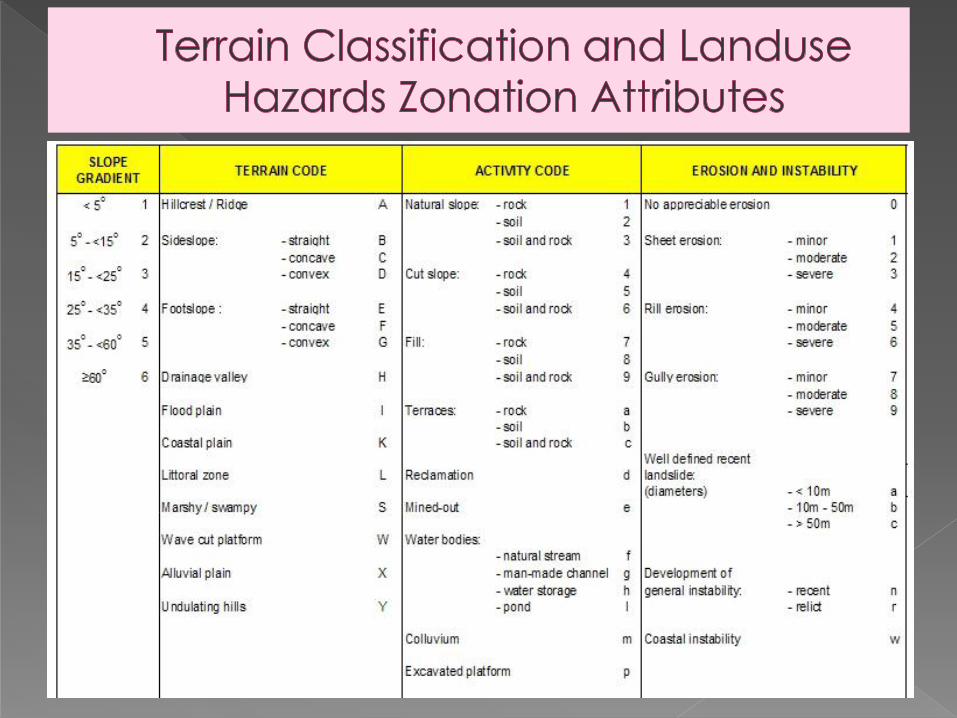
Basic information were collected in the field, involving geology, topography and landform as well as geodynamic features such as landslides and severe erosion.

Four attributes for Terrain Classification: slope gradient
morphology
activity and
erosion & instability
GIS was used to collate and analyse these data to generate various derivative thematic maps

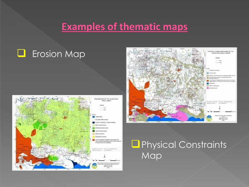
Generated thematic maps:
1) Terrain Classification map
2) Landform map
3) Erosion map
4) Physical Constraints map
5) Engineering geological map
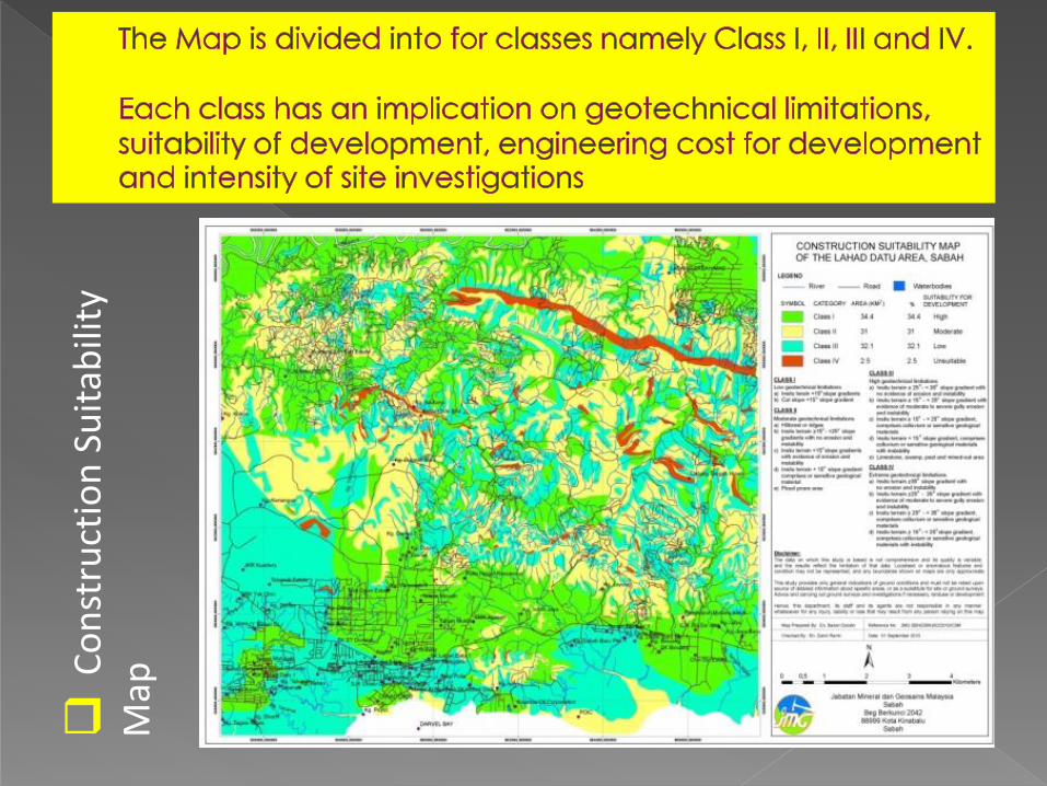
6) Construction Suitability map

Geology map
Slope Gradient Map

Terrain Classification Map
Landform Map
Erosion Map
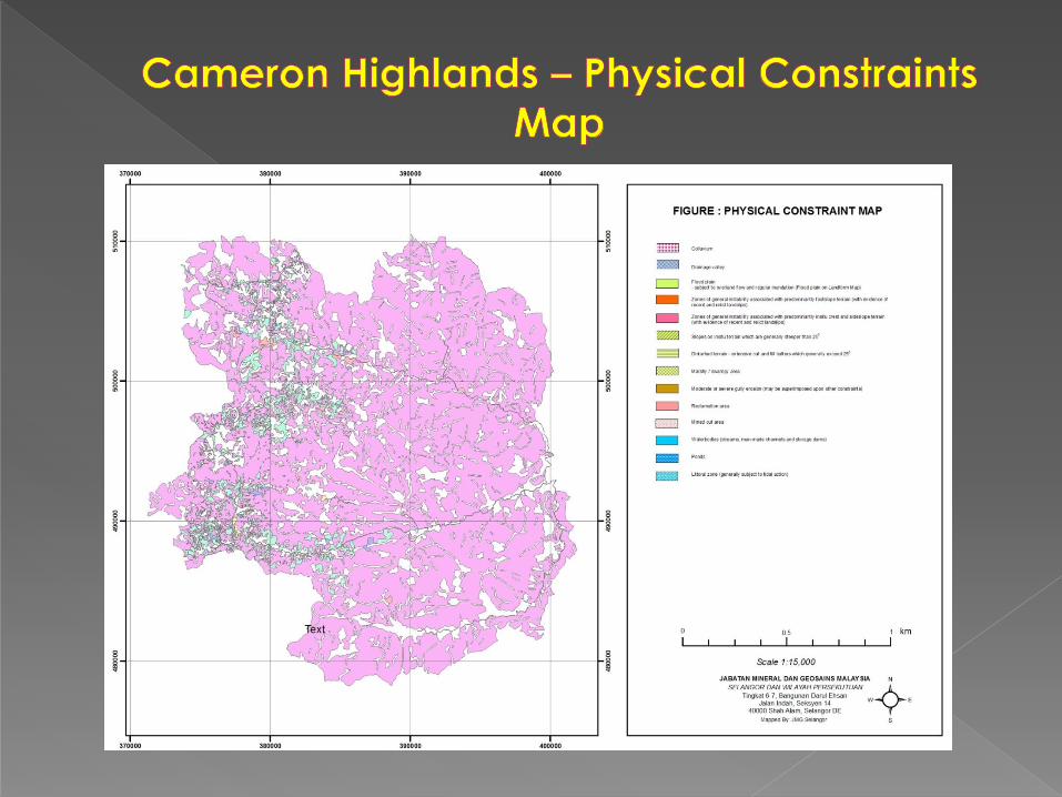
Physical Constraints
Map
C
on
stru
ctio
n S
uit
abili
ty
Map


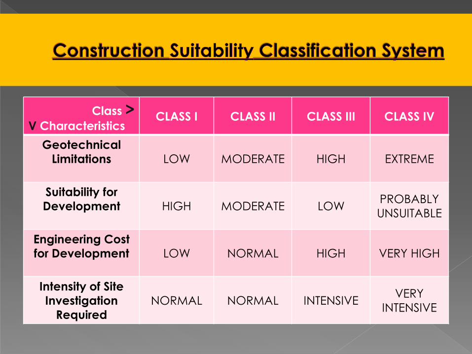
Class > V Characteristics
CLASS I CLASS II CLASS III CLASS IV
Geotechnical
Limitations
LOW MODERATE HIGH EXTREME
Suitability for
Development
HIGH MODERATE LOW PROBABLY
UNSUITABLE
Engineering Cost
for Development
LOW NORMAL HIGH VERY HIGH
Intensity of Site
Investigation
Required
NORMAL NORMAL INTENSIVE VERY
INTENSIVE

CLASS I – Low
Geotechnical Limitations
a) Insitu terrain: < 5o gradients
b) Cut slope: < 5o gradients
CLASS II – Moderate
Geotechnical Limitations
a) Hillcrest or Ridge
b) Insitu Terrain: >15o; <25o slope gradients
with no evidence of erosion or instability
c) Insitu Terrain <15o slope gradients with
evidence of erosion and instability
d) Insitu Terrain <15o slope gradients
comprises of colluvium or sensitive
geological materials
CLASS III – High Geotechnical Limitations
CLASS IV – Extreme Geotechnical
Limitations

CLASS I – Low Geotechnical Limitations
CLASS II – Moderate Geotechnical
Limitations
CLASS III – High
Geotechnical Limitations
a) Insitu Terrain 25 – 35o slope gradients with
no evidence of erosion or instability
b) Insitu Terrain 15 – 25o slope gradients with
no evidence of moderate to severe gully
erosion and instability
c) Insitu Terrain <15o slope gradients
comprises of colluvium or sensitive
geological materials with instability
d) Insitu Terrain 15 – 25o slope gradients
comprises of colluvium or sensitive
geological materials
e) Limestone, swampy, peat and mined-out
areas
CLASS IV – Extreme Geotechnical
Limitations

CLASS I – Low Geotechnical Limitations
CLASS II – Moderate Geotechnical
Limitations
CLASS III – High Geotechnical
Limitations
CLASS IV – Extreme
Geotechnical Limitations
a) Insitu Terrain >35o slope gradients, with no
evidence of erosion or instability
b) Insitu Terrain 25 – 35o slope gradients with
evidence of moderate to severe gully
erosion and instability
c) Insitu Terrain 25 – 35o slope gradients,
comprises of colluvium or sensitive
geological materials
d) Insitu Terrain 15 – 25o slope gradients,
comprises of colluvium or sensitive
geological materials with instability


1. Introduction
2. GIS Application in
a. Geological Terrain Mapping
b. Geohazard Mapping
3. Conclusions
2005
2011

Landform Map
Erosion Map Physical Constraints Map
Construction Suitability Map
Engineering Geology Map
(Integrated with other agencies)
Slope Gradient Map
Geological Terrain and
Landslide Hazard
Mapping in Kundasang
area, Sabah
Monitoring Active Fault & Surface Motion
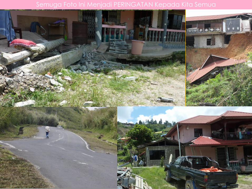
Semuga Foto Ini Menjadi PERINGATAN Kepada Kita Semua

2005 >
^ Apr 2011
< Dis 2011
CONSTRUCTION
SUITABILITY MAP

Our Approach: use
the four attributes
from the geological
terrain mapping plus
a 5th attribute,
namely vegetation
cover and water
seepage.
Generate a landslide
hazard map with four
classes (Chow & Zakaria 2002)
Class
Score Rating Hazards
1 LOW Landslide
Hazard <0.25
2
MODERATE
Landslide
Hazard
0.26 – 0.50
3
HIGH
Landslide
Hazard
0.51 – 0.75
4
VERY HIGH
Landslide
Hazard
>0.76

Landslide risk maps
quantify the
vulnerability of an
area and refer to
the consequences
of the failure on
human activities.
The consequential
effect of landslide
defines the degree
of risk in an area.
Landslide risk scores
are then calculated
using the standard
equation. (Risk = Hazard x Consequence)
Kundasang

Type of RISK Land Use / Premises Weightage
Risk of lives
Critical buildings affected Normal buildings affected Isolated buildings affected Very busy trunk road Busy trunk road
Moderately used trunk road Seldom use trunk road
20 10 5 10 7
5 1
Economic Losses
Damage to farm/park Business area Only access to housing area Temporary diversion > 1 day
Temporary diversion <1 day Alternative road > 5km Alternative road <5km
3 10 6 3
0 3 0
Public Utilities Affected Not affected
10 0
Proximity of building
to suspected
landslide
Very close Close Possibly affected Unlikely to be affected Not affected
10 5 2 0 0
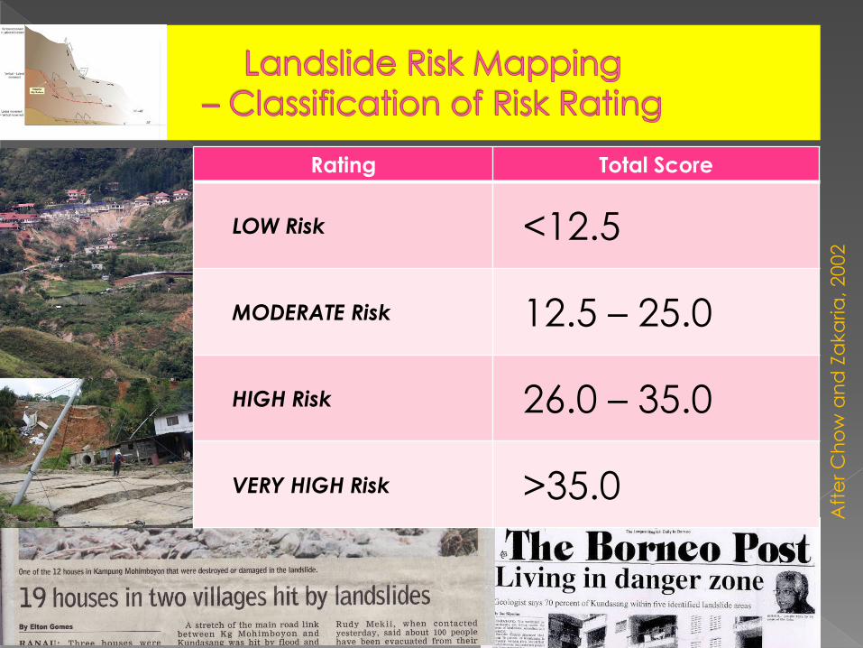
Rating Total Score
LOW Risk
<12.5
MODERATE Risk
12.5 – 25.0
HIGH Risk
26.0 – 35.0
VERY HIGH Risk
>35.0
Aft
er
Ch
ow
an
d Z
aka
ria
, 20
02
1. Introduction
2. GIS Application in
a. Geological Terrain Mapping
b. Geohazard Mapping
3. Conclusions

1. GIS application has been effectively used in analysing and managing geoscience data to produced useful informative maps for landuse and development planning purposes.
2. The GIS approach in geohazards mapping by JMG involved statistical analysis and a heuristic method to establish the hazard ratings of a study area.

3.The geohazards maps produced served as
a guideline to manage and reduce risk to
properties destruction and human casualty.


