30
IMPLEMENTATION

IMPLEMENTATION

US HIGHWAY 53 CORRIDOR STUDY 93
OverviewImplementation of the Highway 53 Corridor Plan requires proactive leadership and collaboration of public agencies and stakeholders at multiplejurisdictional levels, including the City of La Crosse and the Northside Community.
Implementation of the plan is also dependent on the full support and participation of property owners, residents, businesses, and the developmentcommunity. A concerted effort has been made throughout this plan to involve a broad cross-section of the community. Business owners,neighborhood residents, and community leaders have provided input and guidance. Even with a strong commitment, it will take several years beforemany of these recommendations take full shape. The magnitude of redevelopment may seem daunting, however change is constant and the visionfor the Highway 53 Corridor will be the product of individual site redevelopments and street improvements. Every project is important and shouldhelp build toward the long-term vision.
The public improvements associated with the Highway 53 Corridor Plan will act as a catalyst for reinvestment and represent a positive step towardensuring a vibrant long-term business climate and livability for the Highway 53 Corridor. The City has an important role to play in this process, butthe success of this effort will not be possible without the full support and participation of landowners and the development community.
Your participation has improved the study and your continued participation and support will be critical in sustaining the community’s vision forthe Highway 53 Corridor over time. Please consider continuing to be a part of this process by contacting the City Planning Department, yourCouncilperson, or one of many community organizations.. This Corridor Plan is only a framework for the projects and plans that will successfullycomplete this vision .
This Implementation section includes actions that should be considered to integrate the improvements into an ongoing and community buildingstrategy and to gain the most benefit from streetscape and other public improvements.
94
Redevelopment ApproachKey points listed below should be considered as the community begins the redevelopment process for the Highway 53 Corridor:
• COMPREHENSIVE. A single project cannot revitalize the corridor. Only an ongoing series of initiatives can build community support and create lasting progress.
• INCREMENTAL. Small projects make a big difference and they demonstrate that “things are happening.” Large projects can set the tone and establish precedence.
• SELF- HELP. Local leadership can breed long-term success by fostering and demonstrating community involvement and commitment to the revitalization effort.
• PUBLIC+PRIVATE PARTNERSHIP. The redevelopment program needs support and expertise of both the public and private sectors. For an effective partnership, eachpiece must recognize the strengths and weaknesses of the other.
• IDENTIFYING+CAPITALIZING EXISTING ASSETS. One of the projects key objectives is to recognize and make the best use of the Corridor’s unique offerings. Localassets provide the solid foundation for a successful redevelopment initiative.
• QUALITY. From streetscape and storefront design to promotional campaigns and special events, quality must be the primary goal.
• CHANGE. Changing community attitudes and habits is essential to bring about a corridor renaissance. A carefully planned program will help shift public perceptions andpractices to support and sustain the revitalization process.
• ACTION-ORIENTED. Frequent, visible changes in the look and activities of the commercial district will reinforce the perception of positive change. Small but dramaticimprovements accomplished early in the process will remind the community that the revitalization effort is underway.
• INTERIM STRATEGIES. Pilot-to-Permanent or Lighter, Quicker, Cheaper (LQC).
Determine which community partners could assist with programming, community events, and grass-roots improvements. Examples include, but arenot limited to temporary wayfinding signs, parklets, moveable planters, additional/relocated pavement marking, and open street events.

US HIGHWAY 53 CORRIDOR STUDY 95
Redevelopment SitesAt the four identified pulse nodes, this plan calls for reinvestment in Corridor-wide pedestrian improvements, alternate routing for people bikingand walking, and improvements to critical crossings along Highway 53. The Steering Committee recommends beginning with a project that hasthe greatest potential for the convergence of investment in infrastructure and buildings, both public and private. Pulse Node A @ George Streetintersection has the greatest potential for this convergence.
Pulse Node A @ George Street: Bridgeview Plaza Economic Analysis
The Bridgeview Plaza Property has been identified as a potential opportunity for redevelopment of types and scales that could impact marketperceptions of North La Crosse and invite subsequent investment in the area. A high quality redevelopment concept has been developed andillustrated for the site, representing one plausible change scenario. Tangible Consulting Services have evaluated the redevelopment concept froma financial perspective and the findings are the subject of this memorandum.
The development concept represents an ambitious redevelopment of the property. It creates a storefront retail corridor of special character andit offers new public park/plaza spaces. The place-making characteristics of the project would result in maximizing the residential and commercialrents that could be achieved in this particular part of the City—with the caveat that development in this location is pioneering, and thus will notbring the level of returns that would be achieved in parts of the city that are already seen as highly desirable locations.

96
Findings
The analysis finds that the development concept is challenging but potentially achievable and requires significant public sector financial support.Utilizing a range of assumptions, our model estimated the total development cost to be around $100 million, when all aspects of the project areaccounted for. A developer, with typical financing, could support roughly 77% of these costs. This yields a financial gap of around 23% of projectcosts.
A good share of these costs could potentially be derived from capitalizing the future property taxes that the development would generate usinga tax increment financing mechanism. Tax increment financing is an advantageous first choice for addressing a development financial gap such asthis, since it doesn’t add to the tax burden on La Crosse citizens or compete with the funding of other city needs. But the analysis suggests thattax increment financing will not be sufficient to meet the financial need. Additional public financial resources would need to be identified andemployed to advance the project.
Project performance is highly sensitive to the rents that can be achieved by the development. Those rents can’t be projected with a high degreeof accuracy, because the prospective project is quite unique in its location, and in the context that would be built around it. There are no otherdevelopments in the City of La Crosse that are close comparisons. If future rental costs for the apartment component of the project turns outto be $1.65 per square foot instead of $1.75, the public contribution to the project would increase to 26% of project costs. By the same token, iffuture rents are $1.85 per square foot, the public financial support that would be 20% of project costs.
Analysis
This analysis evaluated:• The cost of the project
• The return of the project (in the form of the operating income that would be generated), and
• The amount of development costs that would be supported by a lender and the developer
• The projected rents that the project generates, after deducting operating costs, were used to estimate both the lender contribution and the developer contribution to theproject. The estimated financial gap is simply the part of the total estimated project cost that exceeds the lender and developer contributions.
In reality, a project like this proceeds in multiple phases. To make it manageable, this analysis considered the development as a whole, so that totalcosts were incurred at a single point in time, and rents from all seven buildings were available after the project was completed.

US HIGHWAY 53 CORRIDOR STUDY 97
Assumptions
The findings of this analysis are dependent on the accuracy of a wide range of assumptions, which are detailed in the last page. There will be errorsin the assumptions, since a) the time available to gather information on each variable was not unlimited, and b) it is impossible to make perfectassumptions about costs, market conditions, developer or lender behavior, or what the future will hold. This analysis worked to avoid a pattern oferrors, which would have the effect of producing an overly optimistic or pessimistic assessment of the financial viability of the development concept.
Development Costs:
Acquisition and Site Preparation $5,400,000
Development Cost—Streets and Parks $1,800,000
Development Cost—Seven Buildings $93,400,000
Total Development Cost $100,600,000
For the buildings, cost estimates were derived for construction (hard) costs, soft costs, and developer fees of each component(retail, office, or residential) of each of the seven proposed buildings.
Operating Income:
Residential Gross Rent $7,140,000
Retail Gross Rent $660,000
Office Gross Rent $1,450,000
Total Annual Gross Rent $9,300,000
Rental income was also estimated for each component of each of the seven buildings, based onthe estimated rent per square foot for residential, office and retail areas in the buildings. The seven buildings combined were estimated toproduce around $9.3 million per year in rents, given typical vacancy rates.
Net Operating Income:
Residential Net Operating Income $4,020,000
Retail Net Operating Income $650,000
Office Net Operating Income $990,000
Total Net Operating Income $5,700,000
The net operating income was derived by estimating operating expenses for each of the three development types. After deductingfor operating expenses, the annual net operating income (NOI) for all seven buildings is estimated to be around $5.7 million.
Project Finance:
NOI $5,700,000
Debt Service Coverage Ratio ÷ 1.25
Debt Service $4,530,000
Development Loan $69,600,000The net operating income provides a basis for estimating the size of a loan that project would receive from a lender. This analysis usedassumptions for the lender’s debt service coverage ratio and loan terms that are somewhat conservative, based on current lending norms. Butin the timeframe of this project they could still prove to be overly optimistic, which would result in a greater financial gap

98
The equity that a developer would bring to the project is based on a wide range of considerations, including financial return. A developer haschoices about where to invest his or her resources and a financial cushion will be built into the project because new development is inherently risky.A key financial metric for developers is the projected cash flow of the development after the debt service has been paid (cash flow after financing).The developer’s investment in a project (equity) will be partly based on the project’s projected cash flow after financing.
NOI $5,700,000
Debt Service -$4,530,000
Cash Flow after Financing $1,130,000
Given an estimated 15% ratio between developer equity and its annual return, as measured by its cash flow after financing:
Developer Equity $7,550,000
The estimated financial gap that the development faces is simply the remaining project cost, after the development equity and loan amount areaccounted for. The financial gap represents around 23% of total project costs.
Total Development Cost $100,600,000
Developer Equity - $7,550,000
Loan Amount - $69,600,000
Financial Gap $23,400,000
US HIGHWAY 53 CORRIDOR STUDY 99
Short Term RecommendationsIt is important to establish short-term design steps for organizational and planning tools to implement the redevelopment recommendations, whichinclude the following:
Build Design Standards into the Zoning Ordinance
Build design standards into the zoning ordinance for the most effective and legally sound strategy. If design objectives can be visualized and definedin quantifiable terms, they can be expressed in form-based codes that can be incorporated into the Zoning Ordinance. Definitive standardsdeveloped in response to reasonable goals and objectives are better for developers, less likely to be legally challenged, and more defensible inthe event of legal challenges. This approach would be easiest to administer by the planning staff in the long term. However, in the short term, theformation and authorization of a separate design review committee will work with City Staff to review redevelopment proposals.
There are limitations to the results that can be achieved through zoning. Design standards help achieve a degree of continuity through an area andcertainly prevent development that is truly incongruous and incompatible. However, it is also true that good taste cannot be legislated. Althoughzoning can help a community establish a level of quality and prevent discordant development, it cannot guarantee that development will beaesthetically pleasing.
Site Plan Review
In order for the City to effectively implement the design guidelines recommended by the Task Force and consultants, the City should empoweritself to guide development by bolstering the newly adopted Site Plan Permit process for all development along the Highway 53 Corridor. TheSPR “ensures developments conform to City goals, plans and regulations; preserves and enhances the natural environment; protects existing uses;enhances the economic, residential and institutional communities; grows the City tax base and beautifies the city.” Some of the factors consideredin the SPR process are: consistency with the City’s Comprehensive Plan and Design Guidelines adopted by the City, building setback and build-torequirements, consistent facades, minimum glass requirements, sign controls, minimized curb cuts, parking lot location and buffering, landscape andlighting plans, stormwater management plans, parking requirements and drive-throughs.
100
Develop a Corridor Wayfinding Plan
Wayfinding signs should be installed throughout the Corridor for those driving, walking, and bicycling to assist with finding destinations. Wayfindingshould focus on two specific areas: highlighting destinations off of Highway 53 (for example, the UPTOWNE/Old Towne North business district),and highlighting destinations on Highway 53 for people who are walking or bicycling on a parallel neighborhood street. A wayfinding plan couldfocus specifically on this Corridor or could address the wayfinding more broadly of North of La Crosse.
Organization and Promotion
Currently, no civic organization and/or public bodies are involved in the management, promotion, and/or development of the Highway 53 Corridor.Organizing a diverse group of people to achieve the work tasks, build public/private partnerships, foster ongoing leadership, and provide a unifiedvoice for the area will be the key to whether this plan succeeds or fails.
This section outlines a strategy for organizing interested residents and business owners into an effective advisory group whose mission is to see thatredevelopment is implemented according to the goals and objectives of the plan, to act as an advocacy group for the corridor, and to coordinatepromotional campaigns and small projects.

US HIGHWAY 53 CORRIDOR STUDY 101
Corridor - Wide Ongoing ActivitiesSimultaneously with the phases identified above, the Project Team will undertake the following ongoing activities.
Coordinate Objectives with City Departments
The planning and engineering departments from both the County and City should refer to this document when considering development proposalsalong the Highway 53 Corridor. Developers should work with City and County Staff and refer to the plan when generating design concepts tobetter understand how their property fits into the Corridor Plan and expectations for public/private facilities. Proposed developments shouldfollow the design recommendations in this Plan.
Develop a Financial Plan
The harsh reality of this Plan is that without viable financing, many of the recommendations will not be implemented. Therefore, it is imperative thatthe City of La Crosse and La Crosse County, along with the local business community, research and develop practical financing options to facilitatereal change. Financing projects can be done by qualifying for grant money, borrowing, or bonding. The City and County should create a masterschedule outlining when grant cycles start and are awarded and their relationship to agency capital budget cycles. The funding strategy should beflexible to take advantage of any unexpected opportunities.
Assemble Land
Pursue the acquisition of tax forfeit, foreclosed, or for sale properties identified as necessary to pursue the redevelopment vision created in thisplan for the Highway 53 pulse nodes and could be acquired by the City of La Crosse or La Crosse County. Either entity will be cognizant of theCorridor Plan and the additional right-of-way needs at these intersections.

102
Help People Bike to the Highway 53 Corridor
Demand for bicycling is expected to increase along and adjacent to the Corridor, especially as redevelopment occurs. While dedicated bikewaysare not recommended on Highway 53 as they are on parallel off-streets, additional destinations and anticipated increase in bicycling will generatedemand to and along the Highway 53 corridor. Several steps can help people bike through and to the corridor.• Create a wayfinding system for directing bicycle traffic to the defined pulse nodes along Highway 53. While the wayfinding should direct people to nearby destinations, it
should also direct people from the alternative routes to destinations on Highway 53.
• Identify treatments connecting the alternative routes to Highway 53, especially at the four pulse nodes studied in this plan. Many of the people who bike on Highway 53are trying to reach destinations on Highway 53. Creating safe connections to the corridor will mitigate the additional time, inconvenience, and decreased safety of directingpeople off Highway 53.
• Ensure that as the Corridor is improved adequate secure bicycle parking is provided at visible, safe and convenient locations.
Develop a Private Investment Incentive Fund
Create an incentive program that recognizes businesses making voluntary aesthetic improvements. Supplements such as painting and landscapingcan visually enhance the appeal of an area and areencouraged.
US HIGHWAY 53 CORRIDOR STUDY 103
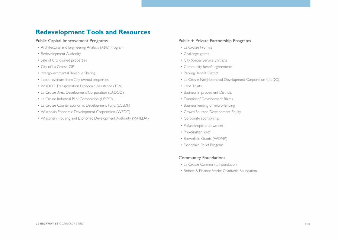
Public Capital Improvement Programs
• Architectural and Engineering Analysis (A&E) Program
• Redevelopment Authority
• Sale of City owned properties
• City of La Crosse CIP
• Intergovernmental Revenue Sharing
• Lease revenues from City owned properties
• WisDOT Transportation Economic Assistance (TEA)
• La Crosse Area Development Corporation (LADCO)
• La Crosse Industrial Park Corporation (LIPCO)
• La Crosse County Economic Development Fund (LCEDF)
• Wisconsin Economic Development Corporation (WEDC)
• Wisconsin Housing and Economic Development Authority (WHEDA)
Public + Private Partnership Programs
• La Crosse Promise
• Challenge grants
• City Special Service Districts
• Community benefit agreements
• Parking Benefit District
• La Crosse Neighborhood Development Corporation (LNDC)
• Land Trusts
• Business Improvement Districts
• Transfer of Development Rights
• Business lending or micro-lending
• Crowd Sourced Development Equity
• Corporate sponsorship
• Philanthropic endowment
• Pre-disaster relief
• Brownfield Grants (WDNR)
• Floodplain Relief Program
Community Foundations
• La Crosse Community Foundation
• Robert & Eleanor Franke Charitable Foundation
Redevelopment Tools and Resources
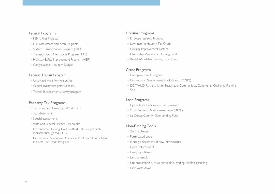
104
Federal Programs
• FEMA Pilot Projects
• EPA assessment and clean-up grants
• Surface Transportation Program (STP)
• Transportation Alternatives Program (TAP)
• Highway Safety Improvement Program (HSIP)
• Congressional Line Item Budget
Federal Transit Program
• Urbanized Area Formula grants
• Capital investment grants & loans
• Transit Enhancement Activity program
Property Tax Programs
• Tax Increment Financing (TIF) districts
• Tax abatement
• Special assessments
• State and Federal Historic Tax credits
• Low Income Housing Tax Credits (LIHTC) – probablyavailable through WHEDA)
• Community Development Financial Institutions Fund - NewMarkets Tax Credit Program
Housing Programs
• Employer assisted Housing
• Low-Income Housing Tax Credit
• Housing Improvement District
• Ownership Workforce Housing Fund
• Rental Affordable Housing Trust Fund
Grant Programs
• Floodplain Grant Program
• Community Development Block Grants (CDBG)
• DOT/HUD Partnership for Sustainable Communities, Community Challenge PlanningGrant
Loan Programs
• Upper Floor Renovation Loan program
• Small Business Development Loan (SBDL)
• La Crosse County Micro Lending Fund
Non-Funding Tools
• Zoning change
• Form based code
• Strategic placement of new infrastructure
• Code enforcement
• Design guidelines
• Land assembly
• Site preparation such as demolition, grading, platting, rezoning
• Land write-down

US HIGHWAY 53 CORRIDOR STUDY 105
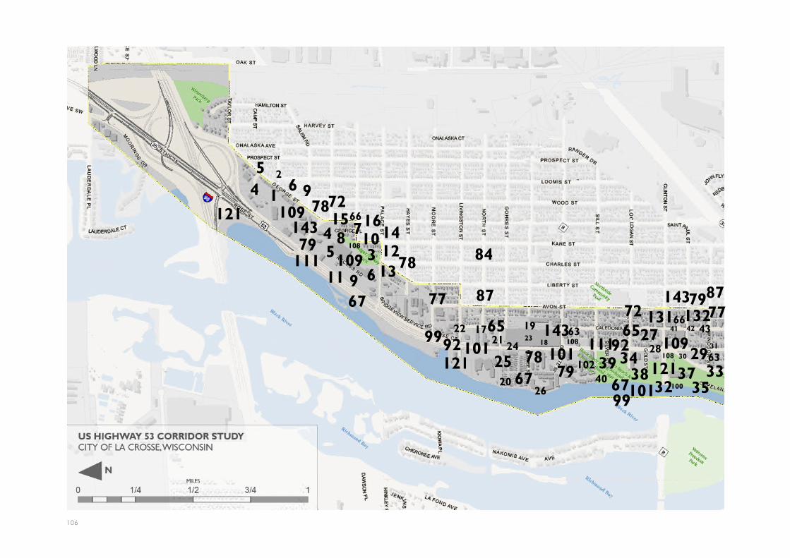
106
67
67 7777
1
25
94 6
15716
45
836
101412
11 913
22 1721
2520
2423
19
18
2640
39 3428
3832
41 42 4327
3735
33
31
30 29
109121143
111 109
121
143111
121
143131 132
109
78
7978
108
84
87
9299
101 101102
108
7879
108 63
666565
67
66
63
72
72
101 100
7987
99
92

US HIGHWAY 53 CORRIDOR STUDY 107
Note: Corridor-wide recommendationsnot numbered on the map.
36
49
45
44
47
56
48
54 5044 52
5153
55 57
62
67
63
76
77
77
72
6563
62131 132 109
111121 111 12185
101
87
101102
79102
78108
101102
100
92 79
78 9978
65
108
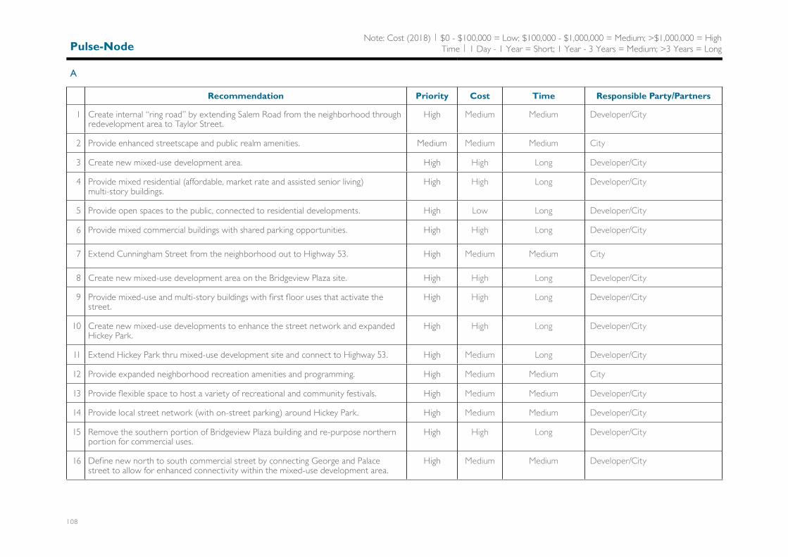
Pulse-Node
A
Recommendation Priority Cost Time Responsible Party/Partners
1 Create internal “ring road” by extending Salem Road from the neighborhood throughredevelopment area to Taylor Street.
High Medium Medium Developer/City
2 Provide enhanced streetscape and public realm amenities. Medium Medium Medium City
3 Create new mixed-use development area. High High Long Developer/City
4 Provide mixed residential (affordable, market rate and assisted senior living)multi-story buildings.
High High Long Developer/City
5 Provide open spaces to the public, connected to residential developments. High Low Long Developer/City
6 Provide mixed commercial buildings with shared parking opportunities. High High Long Developer/City
7 Extend Cunningham Street from the neighborhood out to Highway 53. High Medium Medium City
8 Create new mixed-use development area on the Bridgeview Plaza site. High High Long Developer/City
9 Provide mixed-use and multi-story buildings with first floor uses that activate thestreet.
High High Long Developer/City
10 Create new mixed-use developments to enhance the street network and expandedHickey Park.
High High Long Developer/City
11 Extend Hickey Park thru mixed-use development site and connect to Highway 53. High Medium Long Developer/City
12 Provide expanded neighborhood recreation amenities and programming. High Medium Medium City
13 Provide flexible space to host a variety of recreational and community festivals. High Medium Medium Developer/City
14 Provide local street network (with on-street parking) around Hickey Park. High Medium Medium Developer/City
15 Remove the southern portion of Bridgeview Plaza building and re-purpose northernportion for commercial uses.
High High Long Developer/City
16 Define new north to south commercial street by connecting George and Palacestreet to allow for enhanced connectivity within the mixed-use development area.
High Medium Medium Developer/City
Note: Cost (2018) | $0 - $100,000 = Low; $100,000 - $1,000,000 = Medium; >$1,000,000 = HighTime | 1 Day - 1 Year = Short; 1 Year - 3 Years = Medium; >3 Years = Long

US HIGHWAY 53 CORRIDOR STUDY 109
Pulse-Node
B
Recommendation Priority Cost Time Responsible Party/Partners
17 Create new mixed-use development areas within the pulse node. Medium High Long Developer/City
18 Provide mixed-use and multi-story buildings with first floor uses that activate thestreet on the east side of Highway 53.
Low High Long Developer/City
19 Provide transitional residential densities along Caledonia Street adjacent to existingsingle-family housing.
Medium Medium Long Developer/City
20 Provide mixed residential housing along Black River. Medium High Long Developer/City
21 Provide commercial uses fronting Highway 53 with shared parking opportunities. Medium Medium Long Developer/City
22 Provide mixed commercial buildings with shared parking opportunities at theLivingston Intersection.
Medium High Long Developer/City
23 Extend Rublee Street from the neighborhood out to Highway 53. Low Medium Medium City
24 Provide enhanced streetscape and public realm amenities. Medium Medium Medium City
25 Provide “green” links from Highway 53 to the River along Livingston Street, GohresStreet, and Rublee Street.
High Medium Medium City
26 Create boardwalk from Livingston Street to Black River Beach House. Medium High Long City
Pulse-Node
C
Recommendation Priority Cost Time Responsible Party/Partners
27 Incorporate recommendations from UPTOWNE Summit report. High Medium Short City/North La Crosse BusinessAssociation/Neighborhood Associations/UPTOWNE Collective
28 Create new redevelopment opportunities at the Clinton Street intersection. Medium High Long Developer/City
29 Provide a residential multi-story building in the triangle parcel fronting WindsorStreet.
High Medium Long Developer/City
30 Provide underground parking and enhanced pedestrian facilities along Windsor Street. Low High Long Developer
Note: Cost (2018) | $0 - $100,000 = Low; $100,000 - $1,000,000 = Medium; >$1,000,000 = HighTime | 1 Day - 1 Year = Short; 1 Year - 3 Years = Medium; >3 Years = Long

110
Pulse-Node
C
Recommendation Priority Cost Time Responsible Party/Partners
31 Provide mixed commercial buildings with shared parking opportunities at theWindsor Street intersection.
Low High Long Developer/City
32 Improve connection from Copeland Park to public boat landing and Black River BeachHouse.
High Medium Medium City
33 Improve overall connectivity from adjacent neighborhoods to Copeland Park. High Medium Medium City
34 Improve pedestrian crossings of Rose Street and Copeland Avenue. High Medium Short City
35 Improve Copeland Park. High High Medium City
36 Provide enhanced river connectivity from the park. High Medium Short City
37 Upgrade park recreational amenities and provide more flexible recreational/programspace.
High Medium Medium City
38 Improve pedestrian circulation and access adjacent to public boat landing located onNorth Clinton Street.
High Low Short City
39 Expand Black River Beach House to include a Senior Center. High Medium Medium City
40 Improve landscaping and connectivity to beach area. Medium Low Short City
41 Provide mid-block curb extensions and crosswalk in 1200 block of Caledonia Street. Low Low Short City
42 Require removal of 4 parking spaces allowing for the addition of bike parking on bothsides of street.
Low Low Short City
43 Install sidewalk curb extensions: corner of Caledonia @ Clinton, corner of Caledonia@ St. Paul, and corner of Caledonia @ Windsor.
Medium Low Short City
Note: Cost (2018) | $0 - $100,000 = Low; $100,000 - $1,000,000 = Medium; >$1,000,000 = HighTime | 1 Day - 1 Year = Short; 1 Year - 3 Years = Medium; >3 Years = Long

US HIGHWAY 53 CORRIDOR STUDY 111
Pulse-Node
D
Recommendation Priority Cost Time Responsible Party/Partners
44 Create new mixed-use development areas. Medium High Long Developer/City
45 Provide multi-story mixed-residential and commercial buildings on Monitor Street,east of Rose Street.
Low High Long Developer/City
46 Provide transitional residential densities along Monitor Street adjacent to existingsingle-family housing.
Low Medium Long Developer/City
47 Provide green space linking development opportunity sites with access to wetlandboardwalk trails.
Medium Low Medium Developer/City
48 Provide multi-story mixed-residential buildings on Monitor Street between RoseStreet and Copeland Avenue.
Low Medium Long Developer/City
49 Provide transitional residential densities along Rose Street adjacent to existingsingle-family housing.
Medium Medium Long Developer/City
50 Provide mixed commercial buildings with shared parking opportunities at theintersection of Rose Street and Copeland Avenue.
Medium Medium Long Developer/City
51 Provide multi-story mixed-residential on Monitor Street, west of Copeland Avenue. Low High Long Developer/City
52 Provide multi-story mixed-residential and commercial buildings on the east side ofCopeland, across from Causeway Boulevard.
Medium High Long Developer/City
53 Extend Sumner Street from Monitor Street to Buchner Place. Low Medium Medium City
54 Provide enhanced streetscape and public realm amenities. High Medium Medium City
55 Improve streetscape and public realm amenities along Buchner Place. High Medium Medium City
56 Provide new boardwalk system in wetland area east of Highway 53. Medium Medium Long City
57 Improve greenspace connection south of Buchner Place to link trails and Highway 53. Medium Low Medium City
Note: Cost (2018) | $0 - $100,000 = Low; $100,000 - $1,000,000 = Medium; >$1,000,000 = HighTime | 1 Day - 1 Year = Short; 1 Year - 3 Years = Medium; >3 Years = Long

112
Multi-Modal
Pedestrian
Recommendation Priority Cost Time Responsible Party/Partners
58 Provide a minimum of 6-foot wide sidewalks (8 feet is preferred) throughout theCorridor where feasible.
Medium Medium Medium City
59 Eliminate sidewalk obstructions and gaps. High Medium Medium City
60 Replace failed sidewalk and trail pavements. High Medium Short City
61 Improve snow removal expectations and enforcement. Medium Low Short Property Owners/City
62 Add mid-block pedestrian crosswalks to enhance safety at high volume locations. Medium Low Short City
63 Install sidewalk curb extensions on adjacent side streets to decrease crosswalkdistances, moderate vehicular speeds, provide increased sidewalk space, and defineon-street parking bays.
Medium Low Short City
64 Extend pedestrian scale lighting along the Highway 53 corridor. High Medium Medium City
65 Provide pedestrian scale wayfinding and signage. High Low Short City/NLBA/NAs/UPTOWNE Collective
66 Consider times and locations to program “open streets”. Medium Low Short City/NLBA/NAs/UPTOWNE Collective
67 Provide improved visual and physical connection to the Black River. High Low Medium City
68 Use guidance on Page 83 of the Master Plan to develop sidewalk installation priorities. Medium Low Medium City
Multi-Modal
Bicycle
Recommendation Priority Cost Time Responsible Party/Partners
69 Create frequent safe crossing opportunities. High Medium Medium City
70 Encourage and facilitate classes to educate current and potential bicyclists and buildconfidence in the accessibility, reliability, and safety of the system.
Low Low Short City/NLBA/NAs/UPTOWNE Collective
71 Work with community partners to encourage bicycling as a larger mode share byproviding bicycling facilities in public and private locations and bicycling equipment todisenfranchised groups.
High Low Short City/NLBA/NAs/UPTOWNE Collective
Note: Cost (2018) | $0 - $100,000 = Low; $100,000 - $1,000,000 = Medium; >$1,000,000 = HighTime | 1 Day - 1 Year = Short; 1 Year - 3 Years = Medium; >3 Years = Long

US HIGHWAY 53 CORRIDOR STUDY 113
Multi-Modal
Bicycle
Recommendation Priority Cost Time Responsible Party/Partners
72 Add public bike racks and other amenities near destinations such as schools, transitstops, employers, multifamily housing, shopping, and other biking locations.
High Low Short City/NLBA/NAs/UPTOWNE Collective
73 Continue comprehensive bicycle system planning. High Low Medium City
74 Install more bikeways to grow towards completing the network. High Medium Medium City
75 Require functional bike racks, bike corrals, lockers, and/or indoor parking in newre-developments and assist existing private developments in obtaining them.
High Low Short City
76 Encourage employers to provide amenities such as employee showers and sharedbicycle fleets.
Medium Medium Short City/NLBA/NAs/UPTOWNE Collective
77 Expand the city’s wayfinding system to Highway 53 and highlight access to the paralleland perpendicular bicycle routes.
High Low Short City/NLBA/NAs/UPTOWNE Collective
Multi-Modal
Transit
Recommendation Priority Cost Time Responsible Party/Partners
78 Encourage/Facilitate Transit Oriented Development (TOD) High Low Long City
79 Create a direct “express” route to shopping, Downtown, employment, and servicesto encourage transit-oriented development along the route and make transit a moreattractive option for users.
High Medium Medium City
80 Work with developers, employers, and institutions to increase the transit mode share. High Low Short City/NLBA/NAs/UPTOWNE Collective
81 Enhance the stops with the use of new shelters, lighting, kiosks, monument signs,decorative paving, newspaper corrals, and public art.
High Medium Medium City/NLBA/NAs/UPTOWNE Collective
82 Locate new and relocated transit stops in active and visible places to maximizepersonal security.
High Medium Medium City
83 Evaluate neighborhood routes for improvement. High Low Short City
84 Consider implantation of the Route 6 modifications from the LAPC Great RiverTransit Enhancement Plan 2015-2025.
High Low Short City
Note: Cost (2018) | $0 - $100,000 = Low; $100,000 - $1,000,000 = Medium; >$1,000,000 = HighTime | 1 Day - 1 Year = Short; 1 Year - 3 Years = Medium; >3 Years = Long

114
Multi-Modal
Network Connectivity
Recommendation Priority Cost Time Responsible Party/Partners
85 Improve connectivity from adjacent neighborhoods to Copeland Park. High Medium Medium City
86 Improve bike routes and trails connecting existing trails and bike lanes. High Medium Medium City
87 Install Avon Street Bike Boulevard with Caledonia Street loop from Wall Street toLogan Street with minimal impact to business parking.
High Medium Medium City
88 Install additional Bike lanes (per bike plan and new recommendations). High Medium Medium City
89 Define future traffic calming opportunities. High Low Short City
90 Create detailed maps of safe routes to destinations for bicycling and pedestrians alongthe corridor.
Medium Low Short City/NLBA/NAs/UPTOWNECollective
91 Create boulevards to serve as a buffer from traffic, planting spaces for trees, andspace for snow removal.
Medium Medium Medium City
92 Improve intersections to provide safe and accessible areas for pedestrian and bicyclecrossings, including enhanced crosswalks, signalization, signage, and design techniquesthat encourage drivers to operate at an appropriate speed.
High Medium Medium City
93 Conduct a corridor wide traffic study along Highway 53 to address speeding, safety,and enhanced connectivity routes after completion of the Exit 3 reconstruction andany major redevelopments.
Medium Low Short City
94 Use signs/wayfinding strategies to direct multi-modal traffic between neighborhoodsand the River and highlight access to the parallel and perpendicular bicycle routes.
High Low Short City/NLBA/NAs/UPTOWNECollective
95 Create safe and visible connections between Highway 53 and alternative bicycleroutes.
High Low Short City
96 Provide centralized, easy to access bicycle parking (such as on-street bicycle corrals) atconvenient locations for bicyclists to park their bikes and walk to places along Highway53 within designated pulse nodes.
High Low Short City/NLBA/NAs/UPTOWNECollective
Note: Cost (2018) | $0 - $100,000 = Low; $100,000 - $1,000,000 = Medium; >$1,000,000 = HighTime | 1 Day - 1 Year = Short; 1 Year - 3 Years = Medium; >3 Years = Long

US HIGHWAY 53 CORRIDOR STUDY 115
Multi-Modal
Vehicular
Recommendation Priority Cost Time Responsible Party/Partners
97 Reduce the reliance on single occupancy vehicles by focusing traffic demandmanagement on the Highway 53 corridor.
Medium Medium Medium City/NLBA/NAs/UPTOWNECollective
98 Maintain the efficient and cost-effective movement of freight along the corridor whenmaking changes to accommodate other modes of transportation
High Low Short WisDOT/City
99 Focus roadway reconstruction on major intersections near developing pulse nodes tomaximize the return on transportation investment dollars.
High Medium Long WisDOT/City
100 Consider converting the one-way pair of Rose Street and Copeland Avenue in totwo-way 3-lane and 5-lane streets respectively
Low Medium Long WisDOT/City
Multi-Modal
Intersections
Recommendation Priority Cost Time Responsible Party/Partners
101 All crosswalks should be identified with standard markings, enhanced markings, and/or special paving treatments.
High Low Short City
102 Advance stop bars should be considered at all primary signal-controlled intersectionswith marked crosswalks.
Medium Low Short City
Urban Design
Landscaping + Streetscape
Recommendation Priority Cost Time Responsible Party/Partners
103 Improve riparian landscape edge along the Black River. Medium Low Medium City
104 Enhance landscape character throughout the corridor to reinforce as a gateway to theCity.
Medium Medium Medium City/NLBA/NAs/UPTOWNECollective
105 Plant additional trees along Highway 53 and adjacent streets to improve overallcharacter.
Medium Medium Medium City/NLBA/NAs/UPTOWNECollective
Note: Cost (2018) | $0 - $100,000 = Low; $100,000 - $1,000,000 = Medium; >$1,000,000 = HighTime | 1 Day - 1 Year = Short; 1 Year - 3 Years = Medium; >3 Years = Long
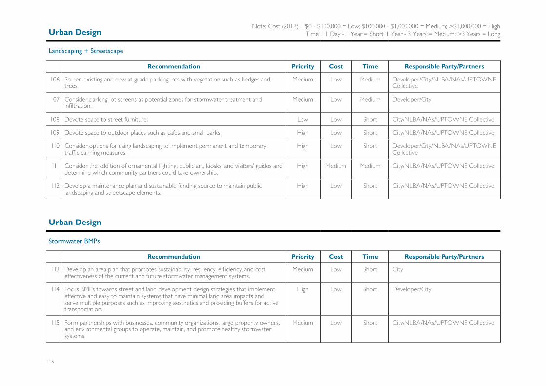
116
Urban Design
Landscaping + Streetscape
Recommendation Priority Cost Time Responsible Party/Partners
106 Screen existing and new at-grade parking lots with vegetation such as hedges andtrees.
Medium Low Medium Developer/City/NLBA/NAs/UPTOWNECollective
107 Consider parking lot screens as potential zones for stormwater treatment andinfiltration.
Medium Low Medium Developer/City
108 Devote space to street furniture. Low Low Short City/NLBA/NAs/UPTOWNE Collective
109 Devote space to outdoor places such as cafes and small parks. High Low Short City/NLBA/NAs/UPTOWNE Collective
110 Consider options for using landscaping to implement permanent and temporarytraffic calming measures.
High Low Short Developer/City/NLBA/NAs/UPTOWNECollective
111 Consider the addition of ornamental lighting, public art, kiosks, and visitors’ guides anddetermine which community partners could take ownership.
High Medium Medium City/NLBA/NAs/UPTOWNE Collective
112 Develop a maintenance plan and sustainable funding source to maintain publiclandscaping and streetscape elements.
High Low Short City/NLBA/NAs/UPTOWNE Collective
Urban Design
Stormwater BMPs
Recommendation Priority Cost Time Responsible Party/Partners
113 Develop an area plan that promotes sustainability, resiliency, efficiency, and costeffectiveness of the current and future stormwater management systems.
Medium Low Short City
114 Focus BMPs towards street and land development design strategies that implementeffective and easy to maintain systems that have minimal land area impacts andserve multiple purposes such as improving aesthetics and providing buffers for activetransportation.
High Low Short Developer/City
115 Form partnerships with businesses, community organizations, large property owners,and environmental groups to operate, maintain, and promote healthy stormwatersystems.
Medium Low Short City/NLBA/NAs/UPTOWNE Collective
Note: Cost (2018) | $0 - $100,000 = Low; $100,000 - $1,000,000 = Medium; >$1,000,000 = HighTime | 1 Day - 1 Year = Short; 1 Year - 3 Years = Medium; >3 Years = Long

US HIGHWAY 53 CORRIDOR STUDY 117
Urban Design
Stormwater BMPs
Recommendation Priority Cost Time Responsible Party/Partners
116 Develop performance measures that show the value of investments and efforts thatgo beyond current requirements.
Medium Low Short City/NLBA/NAs/UPTOWNE Collective
117 Consider adoption of the Urban Street Stormwater Guide from the NationalAssociation of City Transportation Officials.
Medium Low Short City
Urban Design
Wayfinding
Recommendation Priority Cost Time Responsible Party/Partners
118 Prepare a corridor wide wayfinding plan that is cohesive, unique to each context,multi-purpose, and contains several scales (cars, pedestrians, visitors).
High Low Short City/NLBA/NAs/UPTOWNE Collective
119 Integrate wayfinding elements, directing people to key destinations and transit stopsalong the Highway 53 Corridor into streetscape elements (e.g. light poles, transitshelters, monuments, signs) and reinforce a desired streetscape theme.
High Medium Medium City/NLBA/NAs/UPTOWNE Collective
120 Since there are no dedicated bike facilities recommended on Highway 53, wayfindingto alternate bikeways is particularly important.
High Low Short City/NLBA/NAs/UPTOWNE Collective
Urban Design
Gateway Monuments
Recommendation Priority Cost Time Responsible Party/Partners
121 Locate gateway monuments within the amenity area of the public realm. The primarylocations within the study area recommended for gateway monuments include:Gateway Corridor area off of I-90, intersection of Clinton Street and Highway 53at Copeland Park, UPTOWNE (located at Clinton and Rose Street), split of RoseStreet and Copeland Avenue near the intersection of Monitor Street, entrance toDowntown near the La Crosse River.
High Medium Medium City/NLBA/NAs/UPTOWNE Collective
Note: Cost (2018) | $0 - $100,000 = Low; $100,000 - $1,000,000 = Medium; >$1,000,000 = HighTime | 1 Day - 1 Year = Short; 1 Year - 3 Years = Medium; >3 Years = Long

118
Urban Design
Utilities + Advertising
Recommendation Priority Cost Time Responsible Party/Partners
122 To limit the number of utility poles that obstruct the pedestrian environment and toimprove the aesthetics of the corridor, it is recommended that the overhead utilitiesbe buried whenever possible.
Medium Medium Medium City/Private Utilities
123 All signs shall meet the City’s sign ordinance. Medium Low Short Property Owners/City
124 Outdoor advertising signs shall be removed and eliminated as the opportunity existsto improve the aesthetics of the corridor.
Medium Low Long Property Owners/City
Urban Design
Developments
Recommendation Priority Cost Time Responsible Party/Partners
125 Create and adhere to City guidelines and standards for site design, building massing,façade treatments, building materials, signs, and sustainable design practices.
High Low Short City
126 Create mixed-use, multi-story buildings with first floor uses that activate the street. High High Long Developer/City
127 Plan new construction in relation to the surrounding buildings using commonelements from the façade and architecture of neighboring buildings (as appropriate).
High Low Medium Developer/City
128 Positively relate new construction to the street with building elements yet not infringeon the streetscape.
High Low Medium Developer/City
129 Design the first level (street level) to have a human scale with attention to itemsincluding the building entries, f irst floor storefronts, lighting, signage, and windows.
High Low Medium Developer/City
130 Consider building setback from the sidewalk to provide a broader area for pedestrianactivities.
High Low Medium Developer/City
131 Encourage the reuse of positive contributing buildings where possible rather than newconstruction.
High Low Medium Developer/City
132 Incorporate existing historical or character enhancing elements into redevelopment. High Low Medium Developer/City
133 Highlight major building entries. Medium Low Medium Developer/City
134 Create a sense of security by having building windows look onto the street. Medium Low Medium Developer/City
Note: Cost (2018) | $0 - $100,000 = Low; $100,000 - $1,000,000 = Medium; >$1,000,000 = HighTime | 1 Day - 1 Year = Short; 1 Year - 3 Years = Medium; >3 Years = Long

US HIGHWAY 53 CORRIDOR STUDY 119
Urban Design
Developments
Recommendation Priority Cost Time Responsible Party/Partners
135 Use LED or other energy-efficient lighting for new development projects. High Low Short Developer/City
136 Consider solar-powered LED lighting to light exterior spaces. Medium Low Short Developer/City
137 Provide space for organic composting for residential uses on-site or nearby. Medium Low Short City/NLBA/NAs/UPTOWNE Collective
138 Encourage constructing and renovating buildings to meet Leadership in Energy &Environmental Design (LEED) certification standards of silver or better.
Medium Medium Short Developer/City
Corridor-Wide
Zoning/Land-Use
Recommendation Priority Cost Time Responsible Party/Partners
139 Strengthen the built Form through updates to the zoning code. High Medium Short City
140 Combine the efforts of current and future floodplain programs to create a win-winfor the corridor and the neighborhood and industrial floodplain areas.
High Medium Short City
141 Consider elements to the zoning code that allow for positive externalities such asdensity bonuses and transfers of development rights.
High Low Short City
Note: Cost (2018) | $0 - $100,000 = Low; $100,000 - $1,000,000 = Medium; >$1,000,000 = HighTime | 1 Day - 1 Year = Short; 1 Year - 3 Years = Medium; >3 Years = Long

120
Corridor-Wide
Organization + Promotion
Recommendation Priority Cost Time Responsible Party/Partners
146 Create a body to provide corridor-wide organization and promotion and facilitate theimplementation of this plan.
High Low Short City/NLBA/NAs/UPTOWNECollective
147 Create a body to act as an ad-hoc City committee to provide suggestions to CityCouncil and staff.
High Low Short City/NLBA/NAs/UPTOWNECollective
Note: Cost (2018) | $0 - $100,000 = Low; $100,000 - $1,000,000 = Medium; >$1,000,000 = HighTime | 1 Day - 1 Year = Short; 1 Year - 3 Years = Medium; >3 Years = LongCorridor-Wide
Funding
Recommendation Priority Cost Time Responsible Party/Partners
142 Develop public funds to incentivize private investment in existing properties, such asfaçade and business growth grants.
High Medium Short City/NLBA/NAs/UPTOWNE Collective
143 Create TIF districts as a tool for implementing public private partnerships - considerone in the Exit 3 area to Pulse Node B and one in the industrial areas betweenRiverside North and Copeland Park.
High Low Short City
144 Continue to monitor grants and other funding to improve public facilities and servicessuch as parks and transit.
High Low Short City/NLBA/NAs/UPTOWNE Collective
145 Explore methods for the Redevelopment Authority to use and leverage funds forredevelopment projects along the corridor.
High Low Short City/Redevelopment Authority
106
US HIGHWAY53
CORRIDOR STUDY
CITY OF LA CROSSE, WISCONSIN


