Using GIS to Document Cultural Using GIS to Document Cultural Resources After a Natural Disaster Resources After a Natural Disaster Cultural Resource GIS Facility Cultural Resource GIS Facility National Park Service National Park Service Deidre McCarthy Deidre McCarthy [email protected][email protected]202 202 - - 354 354 - - 2141 2141
Transcript
Using GIS to Document Cultural Using GIS to Document Cultural Resources After a Natural DisasterResources After a Natural Disaster
Cultural Resource GIS FacilityCultural Resource GIS FacilityNational Park ServiceNational Park Service
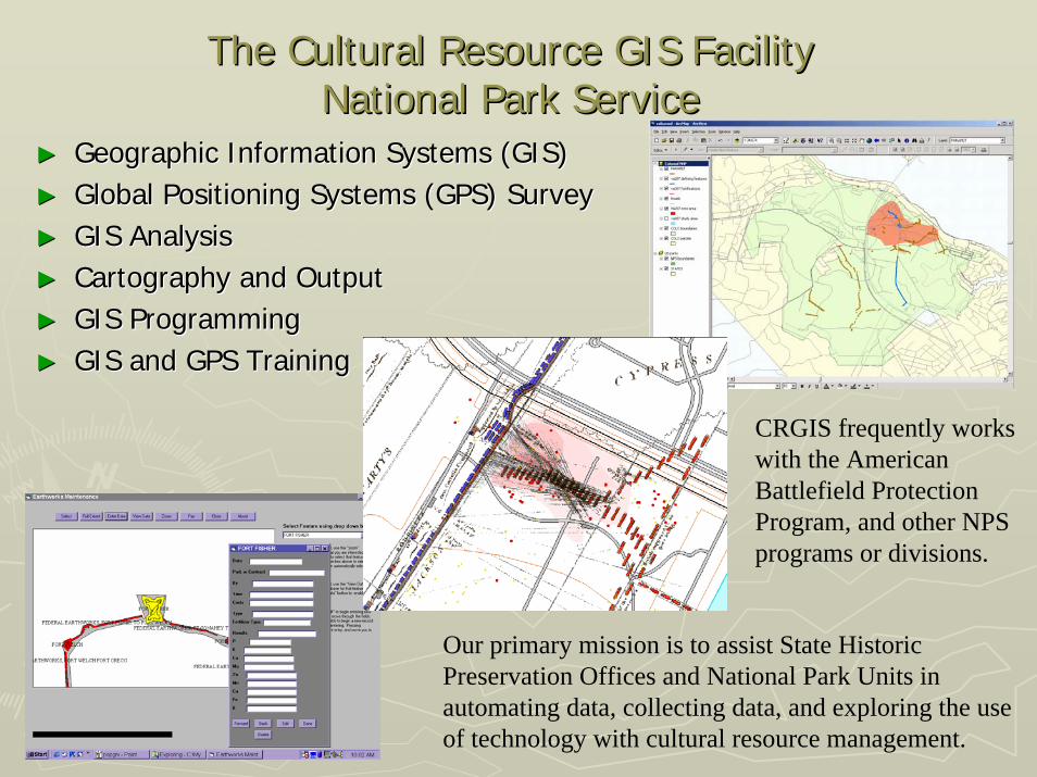
The Cultural Resource GIS FacilityThe Cultural Resource GIS FacilityNational Park ServiceNational Park Service
►► Geographic Information Systems (GIS)Geographic Information Systems (GIS)►► Global Positioning Systems (GPS) SurveyGlobal Positioning Systems (GPS) Survey►► GIS AnalysisGIS Analysis►► Cartography and OutputCartography and Output►► GIS ProgrammingGIS Programming►► GIS and GPS TrainingGIS and GPS Training
Our primary mission is to assist State Historic Preservation Offices and National Park Units in automating data, collecting data, and exploring the use of technology with cultural resource management.
CRGIS frequently works with the American Battlefield Protection Program, and other NPS programs or divisions.
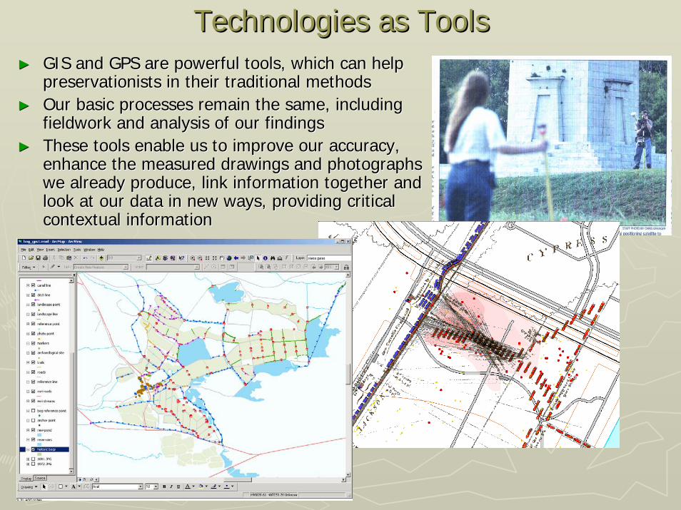
Technologies as ToolsTechnologies as Tools►► GIS and GPS are powerful tools, which can help GIS and GPS are powerful tools, which can help
preservationists in their traditional methodspreservationists in their traditional methods►► Our basic processes remain the same, including Our basic processes remain the same, including
fieldwork and analysis of our findingsfieldwork and analysis of our findings►► These tools enable us to improve our accuracy, These tools enable us to improve our accuracy,
enhance the measured drawings and photographs enhance the measured drawings and photographs we already produce, link information together and we already produce, link information together and look at our data in new ways, providing critical look at our data in new ways, providing critical contextual informationcontextual information
Scope of the Katrina ProjectScope of the Katrina Project►► The Katrina/Rita disaster is the single largest disaster for culThe Katrina/Rita disaster is the single largest disaster for cultural resources that tural resources that
the US has witnessed since the creation of the National Historicthe US has witnessed since the creation of the National Historic Preservation Act Preservation Act in 1966in 1966
►► Among other things, the National Historic Preservation Act creatAmong other things, the National Historic Preservation Act created the National ed the National Register of Historic Places, our nationRegister of Historic Places, our nation’’s catalog of important cultural resourcess catalog of important cultural resources
►► It also stipulates that any Federal undertaking which may adversIt also stipulates that any Federal undertaking which may adversely affect ely affect National Register eligible cultural resources be mitigated National Register eligible cultural resources be mitigated
►► For FEMA, the Katrina/Rita event is the largest Section 106 projFor FEMA, the Katrina/Rita event is the largest Section 106 project ever ect ever
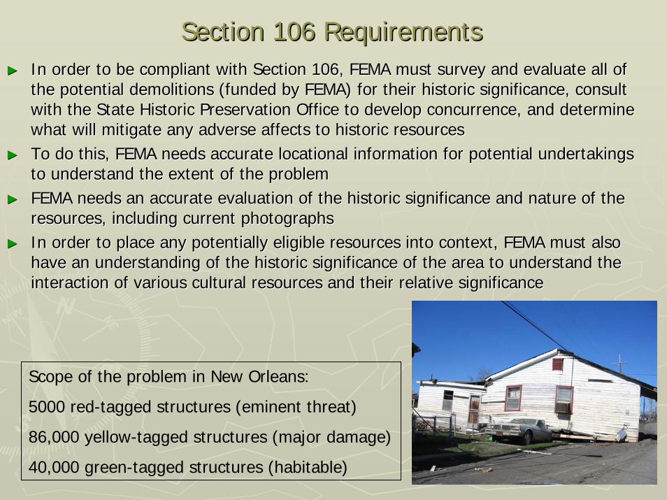
Section 106 RequirementsSection 106 Requirements►► In order to be compliant with Section 106, FEMA must survey and In order to be compliant with Section 106, FEMA must survey and evaluate all of evaluate all of
the potential demolitions (funded by FEMA) for their historic sithe potential demolitions (funded by FEMA) for their historic significance, consult gnificance, consult with the State Historic Preservation Office to develop concurrenwith the State Historic Preservation Office to develop concurrence, and determine ce, and determine what will mitigate any adverse affects to historic resourceswhat will mitigate any adverse affects to historic resources
►► To do this, FEMA needs accurate locational information for potenTo do this, FEMA needs accurate locational information for potential undertakings tial undertakings to understand the extent of the problemto understand the extent of the problem
►► FEMA needs an accurate evaluation of the historic significance aFEMA needs an accurate evaluation of the historic significance and nature of the nd nature of the resources, including current photographsresources, including current photographs
►► In order to place any potentially eligible resources into contexIn order to place any potentially eligible resources into context, FEMA must also t, FEMA must also have an understanding of the historic significance of the area thave an understanding of the historic significance of the area to understand the o understand the interaction of various cultural resources and their relative siginteraction of various cultural resources and their relative significancenificance
Scope of the problem in New Orleans:
5000 red-tagged structures (eminent threat)
86,000 yellow-tagged structures (major damage)
40,000 green-tagged structures (habitable)
Survey and EvaluationSurvey and Evaluation►► FEMA requested the National Park Service, Cultural Resource GIS FEMA requested the National Park Service, Cultural Resource GIS Facility, Facility,
develop a strategy for identifying and evaluating all of the affdevelop a strategy for identifying and evaluating all of the affected properties for ected properties for their National Register eligibility in Orleans Parish, and the stheir National Register eligibility in Orleans Parish, and the surrounding Parishesurrounding Parishes
►► The NPS developed a GPS survey strategy for the properties slateThe NPS developed a GPS survey strategy for the properties slated for demolition d for demolition by the City of New Orleans using Trimble XM handby the City of New Orleans using Trimble XM hand--held receivers with a detailed held receivers with a detailed data dictionary to document the historic characteristics, conditdata dictionary to document the historic characteristics, condition, integrity and ion, integrity and eligibility of each structureeligibility of each structure
►► This accurate survey This accurate survey produces a form of produces a form of documentation, as required documentation, as required by Section 106by Section 106
►► Documentation usually Documentation usually takes the form of drawings takes the form of drawings and photographs, however and photographs, however structures that are structures that are destroyed can not be destroyed can not be drawndrawn
►► FEMA now has GPS FEMA now has GPS documentation, and a GIS documentation, and a GIS view of the area, showing view of the area, showing how these resources relatehow these resources relate
Integration of the Data with FEMA and Local PartnersIntegration of the Data with FEMA and Local Partners►►Part of the NPS strategy included creating a Part of the NPS strategy included creating a GeoDatabase for the resourcesGeoDatabase for the resources
►►GPS data from the survey of redGPS data from the survey of red--tagged tagged buildings is already incorporatedbuildings is already incorporated
►►GPS data from subsequent demolition GPS data from subsequent demolition requests will be incorporatedrequests will be incorporated
►►GPS data from the 25,000 properties that GPS data from the 25,000 properties that have been determined potentially eligible for have been determined potentially eligible for the National Register in New Orleans will be the National Register in New Orleans will be incorporated as a mitigation incorporated as a mitigation
►►GPS data from the surrounding Parishes will GPS data from the surrounding Parishes will be incorporated as demolition continuesbe incorporated as demolition continues
►►The GeoDatabase then becomes part of the The GeoDatabase then becomes part of the FEMA dataset for the disaster as a wholeFEMA dataset for the disaster as a whole
►►The GeoDatabase becomes a form of The GeoDatabase becomes a form of mitigation itself, and is shared with the State mitigation itself, and is shared with the State Historic Preservation Office, other Federal Historic Preservation Office, other Federal Agencies and the CityAgencies and the City
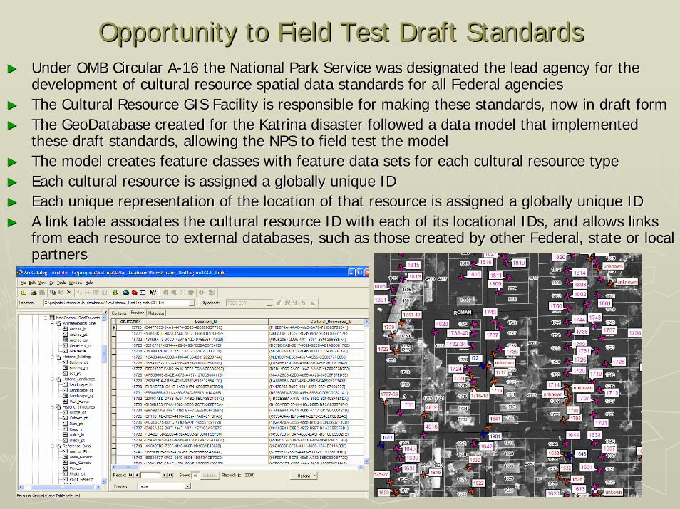
Opportunity to Field Test Draft StandardsOpportunity to Field Test Draft Standards►► Under OMB Circular AUnder OMB Circular A--16 the National Park Service was designated the lead agency for 16 the National Park Service was designated the lead agency for the the
development of cultural resource spatial data standards for all development of cultural resource spatial data standards for all Federal agenciesFederal agencies►► The Cultural Resource GIS Facility is responsible for making theThe Cultural Resource GIS Facility is responsible for making these standards, now in draft formse standards, now in draft form►► The GeoDatabase created for the Katrina disaster followed a dataThe GeoDatabase created for the Katrina disaster followed a data model that implemented model that implemented
these draft standards, allowing the NPS to field test the modelthese draft standards, allowing the NPS to field test the model►► The model creates feature classes with feature data sets for eacThe model creates feature classes with feature data sets for each cultural resource typeh cultural resource type►► Each cultural resource is assigned a globally unique IDEach cultural resource is assigned a globally unique ID►► Each unique representation of the location of that resource is aEach unique representation of the location of that resource is assigned a globally unique IDssigned a globally unique ID►► A link table associates the cultural resource ID with each of itA link table associates the cultural resource ID with each of its locational IDs, and allows links s locational IDs, and allows links
from each resource to external databases, such as those created from each resource to external databases, such as those created by other Federal, state or local by other Federal, state or local partnerspartners
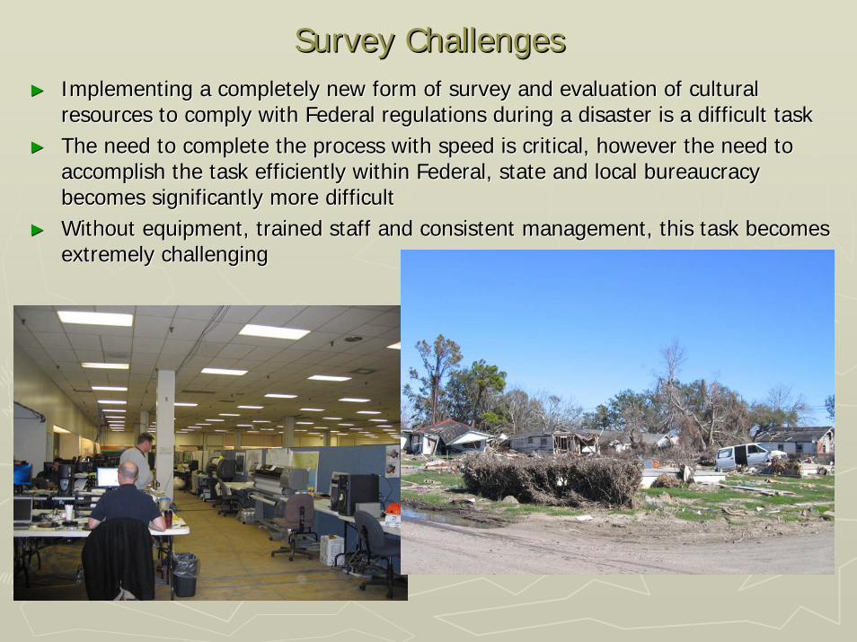
Survey ChallengesSurvey Challenges►► Implementing a completely new form of survey and evaluation of cImplementing a completely new form of survey and evaluation of cultural ultural
resources to comply with Federal regulations during a disaster iresources to comply with Federal regulations during a disaster is a difficult tasks a difficult task►► The need to complete the process with speed is critical, howeverThe need to complete the process with speed is critical, however the need to the need to
accomplish the task efficiently within Federal, state and local accomplish the task efficiently within Federal, state and local bureaucracy bureaucracy becomes significantly more difficultbecomes significantly more difficult
►► Without equipment, trained staff and consistent management, thisWithout equipment, trained staff and consistent management, this task becomes task becomes extremely challengingextremely challenging
Survey ChallengesSurvey Challenges►► Survey work itself in a disaster Survey work itself in a disaster
Assessing the StrategyAssessing the Strategy►► The survey of structures scheduled for demolition, and thereforeThe survey of structures scheduled for demolition, and therefore requiring requiring
assessment by FEMA for Section 106, is now completeassessment by FEMA for Section 106, is now complete►► The successful survey strategy and GeoDatabase implementation ofThe successful survey strategy and GeoDatabase implementation of the draft the draft
standards has allowed the Federal and state partners to quickly standards has allowed the Federal and state partners to quickly and digitally form and digitally form concurrence on National Register eligible properties, through GIconcurrence on National Register eligible properties, through GISS
►► The successful implementation of the data model based on the draThe successful implementation of the data model based on the draft standards has ft standards has been incorporated into a programmatic agreement formed between Fbeen incorporated into a programmatic agreement formed between FEMA and the EMA and the state, calling for the provision of direct links between the FEMstate, calling for the provision of direct links between the FEMA data, the SHPO GIS A data, the SHPO GIS and the City of New Orleans GIS.and the City of New Orleans GIS.
►► The GPS documentation of cultural resources, GIS data produced, The GPS documentation of cultural resources, GIS data produced, and the method of and the method of reviewing each site for Section 106 purposes is digital for the reviewing each site for Section 106 purposes is digital for the first time, and now first time, and now serves as a mitigation or treatment measure for the first timeserves as a mitigation or treatment measure for the first time
Author InformationAuthor Information
Deidre McCarthyDeidre McCarthyArchitectural historianArchitectural historianCultural Resource GIS FacilityCultural Resource GIS FacilityHeritage Documentation ProgramsHeritage Documentation ProgramsNational Park ServiceNational Park ServiceDepartment of the InteriorDepartment of the Interior1849 C Street, N.W. (2270)1849 C Street, N.W. (2270)Washington, D.C. 20240Washington, D.C. 20240--00010001Voice: 202.354.2141Voice: 202.354.2141Fax: 202.371.6473Fax: [email protected][email protected]