18
Using Pictometry Oblique Imagery with ArcGIS 10 Jeff Leonhard District Manager
Using Pictometry Oblique Imagery with
ArcGIS 10
Jeff LeonhardDistrict Manager

Agenda
• Why specialized
tools/extensions are
needed
• How can you use
Pictometry Intelligent
Oblique Imagery with
your GIS?
• Live Demonstration of
new ArcGIS Pictometry
Powrsuite Tools
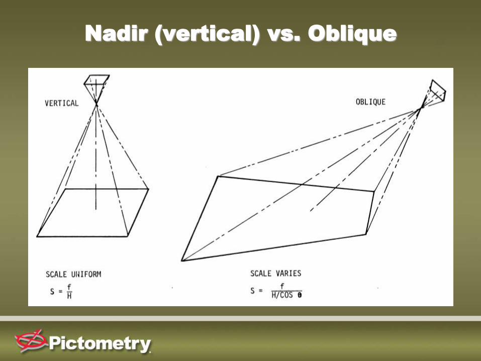
Nadir (vertical) vs. Oblique

4”
5”
6”
Oblique Image Resolution
varies from Front to Back
Oblique Image Resolution
(Ground Sample Distance)
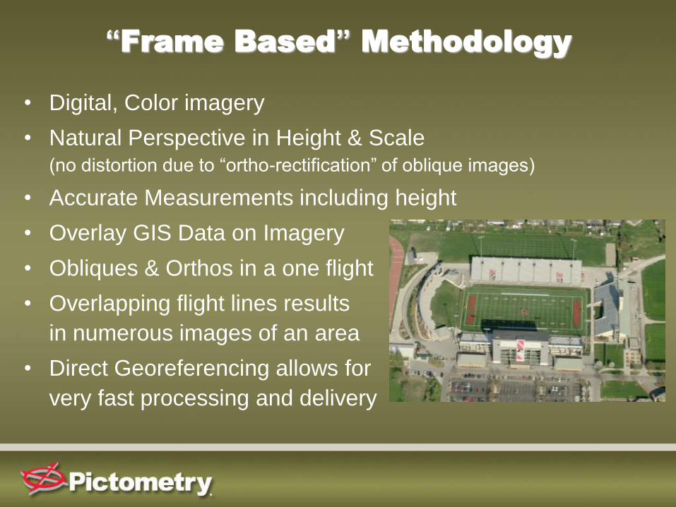
• Digital, Color imagery
• Natural Perspective in Height & Scale (no distortion due to “ortho-rectification” of oblique images)
• Accurate Measurements including height
• Overlay GIS Data on Imagery
• Obliques & Orthos in a one flight
• Overlapping flight lines results
in numerous images of an area
• Direct Georeferencing allows for
very fast processing and delivery
“Frame Based” Methodology

How Can You Use Oblique Imagery
with your existing GIS?
• Pictometry Desktop Software – Electronic Field Study (EFS)
• Pictometry Web-based Solutions– Pictometry Online (POL) & Self Hosted POL
• Pictometry SDK’s are available for customers and business partners to build custom integrations
• Various GIS, CAMA and 911 mapping vendors already offer existing, proven integrations with their software packages– Intergraph, True Automation, Tyler Technologies, Schneider Corp,
39 Degrees North, WTH, Manatron, PlantCML, Positron, etc.
• ESRI – Multiple integration options with various products

ESRI Integrations
PowrSuite ArcMap Extension
• Developed in cooperation with ESRI
• Included at no additional cost to Pictometry Customers
• True extension, runs within ArcMap
• Compatible with ArcMap 10 (and previous versions)
• DOES NOT require installation of any other Pictometry
software (i.e., EFS)
• GIS overlays are enabled and Pictometry measurement
tools are built in
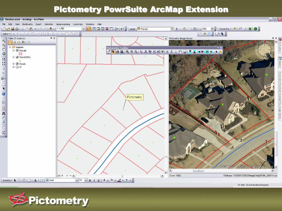
Pictometry PowrSuite ArcMap Extension
ESRI Integrations
PowrSuite ArcMap – POL Extension
• Similar functionality to standard extension
• Web-based, imagery is accessible via a Pictometry
Online login
• DOES NOT require imagery to be stored locally (ideal
for those requiring access to large areas of imagery –
i.e., statewide coverage, etc.)

Pictometry PowrSuite ArcMap - POL Extension
ESRI Integrations
PowrSuite ArcMap Transform
• ArcMap can now read and display Pictometry Oblique
Imagery directly in the data frame!
• On-the-fly virtual Oblique Mosaic creation
• Only available in ArcGIS 10
• Oblique Images are ortho-rectified in order to be
displayed in the data frame - will result in distortion
similar to “push broom” style ortho-rectified oblique
imagery
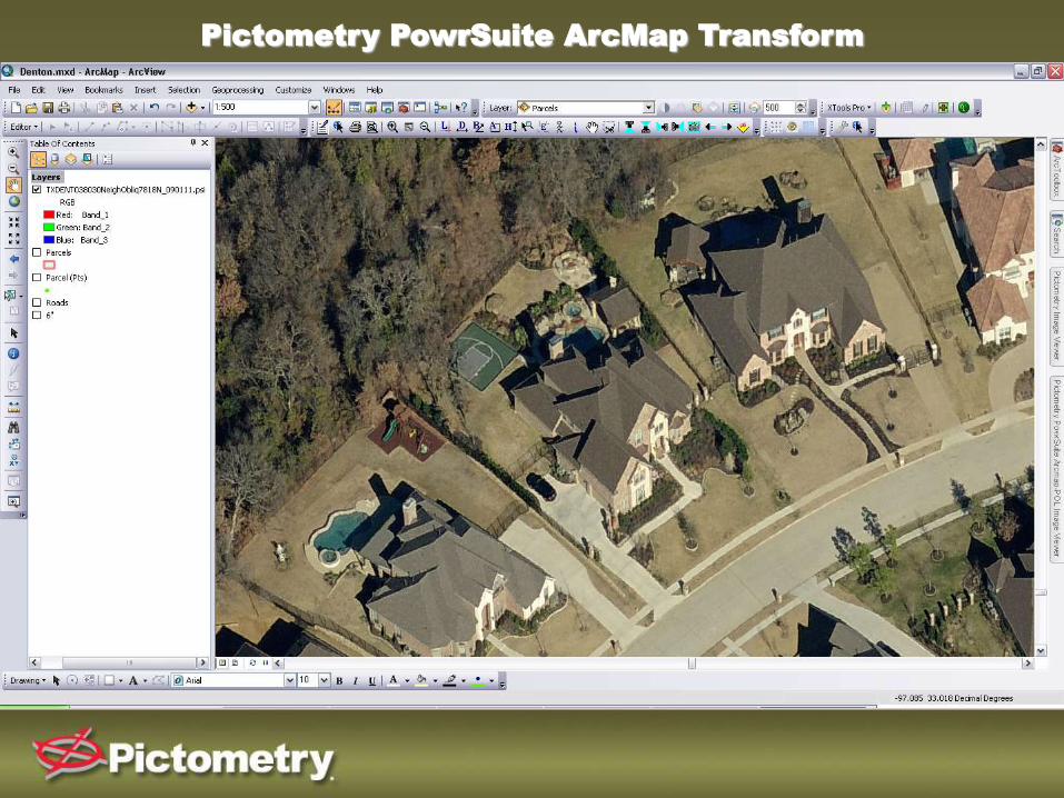
Pictometry PowrSuite ArcMap Transform
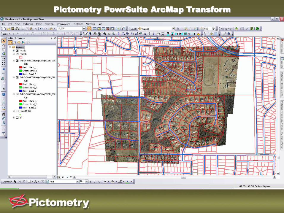
Pictometry PowrSuite ArcMap Transform

• Interfaces using Pictometry Image Navigator API
– Core technology of both Pictometry Online & Self Hosted POL
– JavaScript based
– Includes all major functionality of EFS (view, navigate, measure,
annotate, GIS overlays)
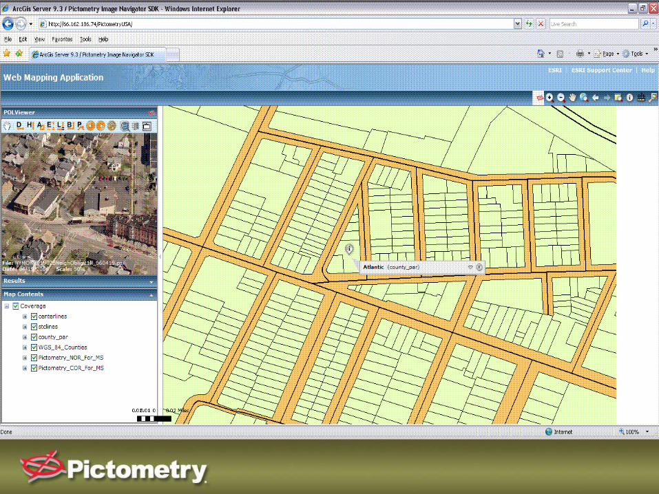
ESRI Integrations
ArcGIS Server
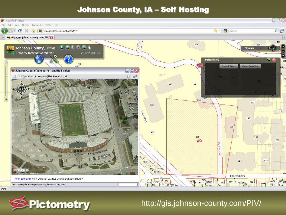
Johnson County, IA – Self Hosting
http://gis.johnson-county.com/PIV/
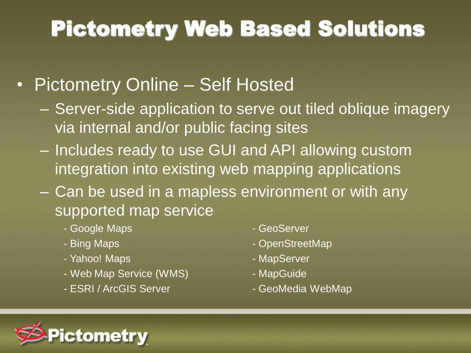
Pictometry Web Based Solutions
• Pictometry Online – Self Hosted
– Server-side application to serve out tiled oblique imagery
via internal and/or public facing sites
– Includes ready to use GUI and API allowing custom
integration into existing web mapping applications
– Can be used in a mapless environment or with any
supported map service- Google Maps - GeoServer
- Bing Maps - OpenStreetMap
- Yahoo! Maps - MapServer
- Web Map Service (WMS) - MapGuide
- ESRI / ArcGIS Server - GeoMedia WebMap
Live Demonstration of
Oblique Technology


