Page 1
CE-751 Urban Transportation Systems Planning
Assignment No. 04
Study of Traffic Analysis Zones in Mumbai
Metropolitan Region (MMR)
Date of submission : 02/09/2013
Submitted by:
Dheeraj Vijay Sawant
133040004
Page 3
Table of Contents
4.1. Introduction ................................................................................................................ 1
4.2. Traffic Analysis Zones ............................................................................................... 1
4.3. Mumbai Metropolitan Region .................................................................................... 2
4.4. Traffic Analysis Zones in MMR ................................................................................ 4
4.4.1. Surveys done in these TAZs................................................................................ 4
4.5. Outcomes from the Study ........................................................................................... 5
4.5.1. Inter-City Bus Terminals ..................................................................................... 5
4.5.2. Truck Terminals: ................................................................................................. 6
4.5.3. Corridor Development......................................................................................... 6
4.5.4. Rail Network till 2031 ......................................................................................... 7
4.6. Cost Estimates ............................................................................................................ 8
4.7. Conclusion .................................................................................................................. 9
4.8. References .................................................................................................................. 9
Table of Tables
Table 1: % growth of various modes in last 15 years in MMR ............................................. 3
Table 2 : TAZs as per sub-regions of MMR ......................................................................... 4
Table 3 : Recommended Highway Corridors till 2031.......................................................... 7
Table 4 : Suburban lines for Horizon Year 2031 .................................................................. 7
Table 5 : Project Cost Estimates till 2031 ............................................................................. 8
Table of Figures
Figure 1:Layout of Mumbai Metropolitan Region ................................................................ 3
Page 5
1
Assignment No. 04
Study of Traffic Analysis Zones in Mumbai
Metropolitan Region (MMR)
4.1. Introduction
Traffic is a major problem in most of the larger cities of the world. When it comes to
megacities like Mumbai, Jakarta, Delhi etc., this problem aggravates. Availability of land is
the major issue and hence any redevelopment plan for the transportation system in the city
requires very extensive planning. During this planning, not only the city, but the surrounding
regions also have to be considered. Here comes in the consideration of the metropolitan
region which includes the major city along with the surrounding areas which may
significantly contribute to the traffic moving in or out of the city under consideration daily.
For planning of the systems of this area, if the survey is done for the area as a whole,it may
not yield the representative results e.g., certain area has more pedestrian population in daily
trips than vehicular population. In this case the measures required for that area may differ
from an area having more vehicular population. So, for this purpose, the metropolitan region
is divided into various number of zones and surveys carried out separately to get the zonal
traffic analysis. Such a categorisation of the larger area helps in beter analysis of the data,
better implementation of the strategies and better economic maintenance of the
transportation systems.
4.2. Traffic Analysis Zones
A traffic analysis zone is a unit of geography most commonly used in conventional
transportation planning models. The size of the zone varies, but for typical metropolitan
planning software, a zone of under 3000 people is common. The spatial extent of the zones
typically varies in models, ranging from very large in the areas on outskirts to as small as
blocks or buildings in CBD. There is no technical reason so as to why zones cannot be as
small as buildings, however additional zones add to the burden. Zones are constructed by
census block information. Typically these blocks are used in the transportation models by
providing socio-economic data. States differ in the socio-economic data that they attribute
to the areas. Most often the critical information is the number of automobiles per household,
Page 6
2
household income and employment within these zones. This information helps to further
understand the trips that are produced or attracted within the zone. This is typically done to
eliminate unneeded area to limit the “computational burden”.
4.3. Mumbai Metropolitan Region
The Mumbai Metropolitan Region is a metropolitan area consisting of the metropolis of
Mumbai and its satellite towns. Developing over a period of 20 years, today it consists of
seven municipal corporations and fifteen smaller municipal councils. The entire area is
overseen by the Mumbai Metropolitan Region Development Authority (MMRDA), a
Maharashtra State Government organisation in charge of town planning, development,
transportation and housing in the region. The MMRDA was formed to address the challenges
in planning and development of the integrated infrastructure for the metropolitan region. The
areas outside of Brihan Mumbai( Greater Mumbai) and Navi Mumbai have lacked organised
development. Navi Mumbai, developed as one of the largest planned cities in the world, was
promoted by a Maharashtra Government qwned company, City and Industrial Development
Corporation(CIDCO). The region has had problems related to haphazard and illegal
development due to rapid urbanisation.
The MMR covers an area of about 4355 sq.km. It contains 1500 sq. km. of developable area
and supports an overall density of 1300 persons/sq.km. it comprises of 1180 villages, 37
census towns, 13 municipal councils, and seven municipal corporations. It has the Arabian
Sea coast to the west and south, joins Gujarat in the north and merges with rest of
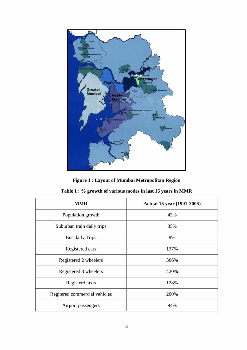
Maharashtra in the east. The map of MMR showing its subregions is shown in the figure.
With rapid industrialisation and urbanisation in the last few decades, the population has 9.9
million in 1981 to 20.8 million in 2005.out of that 17% live in Island City of Greater
Mumbai and 60% in suburbs of Greater Mumbai and Navi Mumbai. The population has led
to densities as high as 45,900 /sq.km in Island City and more than 20000 /sq.km in the
suburbs. The MMR is well served by major rail and road networks but have reached their
capacity and require expansion at the earliest. For this purpose, a detailed study was carried
out in 2005 titled as “ Comprehensive Transportation Study” for Mumbai Metropolitan
Region. It was carried out by LEA associates for the MMRDA. They studied the current
traffic scenario in the region, analysed it and have put forth a detailed plan for the expansion
of the transportation network in MMR.
Page 7
3
Figure 1 : Layout of Mumbai Metropolitan Region
Table 1 : % growth of various modes in last 15 years in MMR
MMR Actual 15 year (1991-2005)
Population growth 43%
Suburban train daily trips 35%
Bus daily Trips 9%
Registered cars 137%
Registered 2 wheelers 306%
Registered 3 wheelers 420%
Registerd taxis 128%
Regitered commercial vehicles 200%
Airport passengers 94%
Page 8
4
4.4. Traffic Analysis Zones in MMR
MMR has been divided into 1030 traffic analysis zones (TAZs) as per the recently
completed, World Bank funded Comprehensive Transportation Study (CTS) of Mumbai.
Table 2 : TAZs as per sub-regions of MMR
Subregion of MMR Number of TAZs
Greater Mumbai 577
Northwestern Region 93
Northeastern Region 222
Navi Mumbai Region 66
Neral Karjat Region 10
Panvel Uran Region 20
Pen Alibaug Region 9
Rural areas 33
Total 1030
The above mentioned zoning has been done for the travel demand analysisof the Mumbai
Metropolitan Region. Six purposes (Home based work office, home based work industry,
home based work others, home based education, home based others and non home based)
and six modes( suburban train, car, auto, 2 wheeler, bus, taxi) were considered during
carrying out the Comprehensive Transportation Study.
4.4.1. Surveys done in these TAZs
The CTS carried out in the MMR consisted of various different surveys covering all modes
of transport and maximum possible population. Following is the list of various surveys
carried out in the CTS:
Home Interview Survey (66000 sample size)
Road Network Inventory Survey (2300 km)
Page 9
5
Outer Cordon/ Sub Regional Cordon/ Inner Cordon/Mid-block count surveys (93
locations)
Rail Passenger surveys
Speed-flow surveys (for developing Volume-Delay functions for 16 carriageway
types)
Terminal surveys
Journey Speed surveys (550 kms)
IPT surveys (50 locations)
Pedestrian count surveys (50 locations)
Workplace Surveys (5000 sample size)
In addition to above surveys, GIS based maps for the entire MMR has been prepared
including the landuse details and development plans. Based on these surveys, a database on
household socioeconomic and travel characteristics of the region has been prepared for
detailed travel demand modelling to study the future transport network requirements of the
MMR. Based on these results, a conceptual transport network for horizon year 2031 and
some short term traffic engineering measures for the year 2016 and beyond has been
prepared in the CTS keeping in view the goals and objectives set for the future MMR. It is
also based on the existing transport network, planned highway, suburban and metro corridors
by various planning organisations, extending the transport network in to the greenfield areas
and improving the connectivity to various growing clusters of the region.
4.5. Outcomes from the Study
The surveys carried out were used to formulate the development programs pertaining to the
various modes. Some of the changes are:
4.5.1. Inter-City Bus Terminals
Local bus transportation demands of the people within the urban areas are met by the local
transportation organizations/ undertakings operated by the respective municipal
corporations. Long distance and inter regional travel demands of the MMR are met by the
state road transportation corporations and private bus operators. It was recommended that,
the MMR needs 4 interstate bus terminals and 13 bus stations by 2031 and the tentative
locations are as follows:
Inter –State Bus Terminals:
Page 10
6
1. Near Wadala Truck Terminal, MCGM
2. Near Mira-Bhayender
3. Kalyan area
4. Panvel Area
Inter-City Bus Terminals
1. Western Suburbs of MCGM : In between Bandra and Borivali
2. Eastern Suburbs of MCGM : In between Kurla and Mulund
3. Western part of Thane Municipal Corporation area
4. Nerul in NMMC
5. Kalyan Dombivali Municipal Corporation area
6. Vasai/Virar area
7. Pen SEZ area
8. Bhiwandi-Nizampur MC area
9. Mira-Bhayender MC area
10. Navgarh-Manikpur Municipal Council area
11. Alibaug Municipal Council area
12. Karjat Municipal Council area
13. Badlapur Municipal Council area
4.5.2. Truck Terminals:
5 major truck terminals and 10 mini truck terminals have been proposed for the horizon year
2031, taking into consideration the expected Dedicated Rail Freight Corridor (DRFC). The
major truck terminal locations are as follows:
1. On DRFC, near boundary of MMR on NH-8 (Mumbai-Ahmedabad)
2. On DRFC, near Taloja Industrial Area
3. Near JNPT
4. Near the poposed International Airport in Navi Mumbai
5. Near intersection of NH-3(Mumbai-Nashik) and DRFC
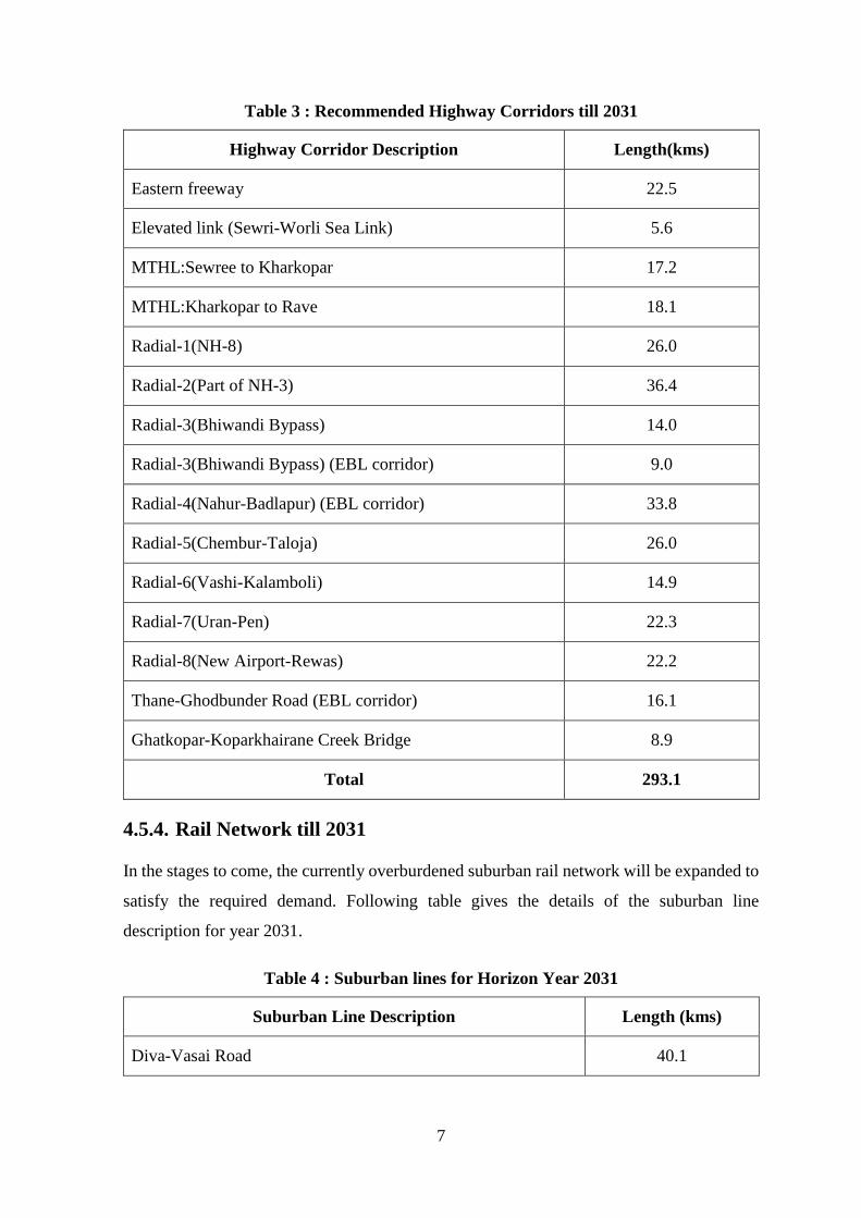
4.5.3. Corridor Development
Following table gives the details of the planned corridors for horizon year 2031.
Page 11
7
Table 3 : Recommended Highway Corridors till 2031
Highway Corridor Description Length(kms)
Eastern freeway 22.5
Elevated link (Sewri-Worli Sea Link) 5.6
MTHL:Sewree to Kharkopar 17.2
MTHL:Kharkopar to Rave 18.1
Radial-1(NH-8) 26.0
Radial-2(Part of NH-3) 36.4
Radial-3(Bhiwandi Bypass) 14.0
Radial-3(Bhiwandi Bypass) (EBL corridor) 9.0
Radial-4(Nahur-Badlapur) (EBL corridor) 33.8
Radial-5(Chembur-Taloja) 26.0
Radial-6(Vashi-Kalamboli) 14.9
Radial-7(Uran-Pen) 22.3
Radial-8(New Airport-Rewas) 22.2
Thane-Ghodbunder Road (EBL corridor) 16.1
Ghatkopar-Koparkhairane Creek Bridge 8.9
Total 293.1
4.5.4. Rail Network till 2031
In the stages to come, the currently overburdened suburban rail network will be expanded to
satisfy the required demand. Following table gives the details of the suburban line
description for year 2031.
Table 4 : Suburban lines for Horizon Year 2031
Suburban Line Description Length (kms)
Diva-Vasai Road 40.1
Page 12
8
Panvel-Jite-Thal 60.9
Rewas Port(New Link) 10.6
Panvel-Karjat 27.6
Panvel-Uran 26.9
Khakopar-Jite (new link) 22.9
Ranjanpada-Seawood(new link) 13.9
Thal-Alibag(new link) 5.4
Diva-Panvel 26.7
Thane-Bhiwandi 12.5
Total 247.5
Along with these, Metro Rail has been proposed in stages. The total length of the metro rail
till the year 2031 has been planned to reach 435.5 kms with the 11.4 kms Phase-I between
Versova – Andheri – Ghatkopar scheduled to start operations parially in the year 2013 and
become fully operational in early 2014.
4.6. Cost Estimates
The following table provides an overview of the overall costs that will be incurred on the
undertaken projects till year 2031. The cost estimates have been separated as per the different
modes of transport in which they will be invested in.
Table 5 : Project Cost Estimates till 2031
Component 2008-2031
Length (kms) Cost(Rs. Crores)
Metro System 435 108373
Suburban Railway System 248 31418
Highway System 1551 57374
Highway Corridors with EBL 79 1695
Page 13
9
Bus System 4280
Passenger Water Transport 480
Truck and Inter-Bus Terminals 3040
Total 2422 Rs. 2,05,661
4.7. Conclusion
1. The Traffic Analysis Zones of MMR help in the proper categorisation of the
developmental plans.
2. Use of Traffic Analysis Zones for the study shows that the densely populated areas of
MCGM, NMMC and TMC require immediate attention.
3. Major emphasis in the developmental plan has been laid on the Rail and Metro network
since these help in mass transit with lesser per capita space requirement.
4.8. References
1. Mir, M., Rao, K. and Hunt, J., (2010). “Space Development Modelling of Urban
Regions in Developing Countries”, Journal of Urban Planning and Development. Vol.
136, pp 75-85.
2. LEA Associates.,(2005). “Comprehensive Transportation Study of Mumbai
Metropolitan Region – The TranSforM Project”, Mumbai.
3. Traffic Analysis Zones – Wikipedia, the Free Encyclopedia. (2013). Traffic Analysis
Zones – Wikipedia, the Free Encyclopedia. Available at :
https://en.wikipedia.org/wiki/Traffic_analysis_zone. [Accessed : 16th August 2013]


![UTSP-Part I [Compatibility Mode]](https://static.documents.pub/doc/80x56/577ce4e11a28abf1038f4ec7/utsp-part-i-compatibility-mode.jpg)


