V2V- and V2X-Communication data within a distributed computing platform for adaptive radio channel modelling Florian Pinzel * , J¨ org Holfeld , Andrej Olunczek , Paul Balzer † , Oliver Michler * * Chair of Transport Systems Information Technology, Technische Universit¨ at Dresden, Germany Email: {florian.pinzel, oliver.michler}@tu-dresden.de Fraunhofer Institute for Transportation and Infrastructure Systems IVI, Dresden, Germany Email: {joerg.holfeld, andrej.olunczek}@ivi.fraunhofer.de † MechLab Engineering UG, Dresden, Germany Email: [email protected]Abstract—This paper presents findings of the collection and exploitation process of V2X communication data with the aim of developing a measurement data-based radio channel model for the ITS frequency range around 5.9 GHz. Collected under real world conditions, connectivity quality measurements of ETSI ITS G5 communication data form the basis of the presented model prototype. The paper provides insight into the installation and configuration of the communication hardware used. Further- more, the transmission process of accumulated as well as live data from the vehicles to a big data platform using the IoT message protocol MQTT is investigated. There, the communication data is enriched with other geographically referenced open source data. Finally, the development of a prototype V2X radio channel model using a machine learning process is presented. The model is a helpful instrument for predicting reception qualities in the ITS radio range for previously unknown receiver positions and thus a prerequisite for two exemplary presented use cases. Index Terms—Vehicle-to-X Communication, ETSI ITS G5, DSRC, Tensorflow Regression Network I. I NTRODUCTION A. Problem Formulation With increasing complexity of Vehicle-to-Anything (V2X) applications the need to ensure robustness and integrity over the entire transmission path increases as well. The use of so-called radio propagation models enables the evaluation of characteristics and limiting factors of a propagation channel. Due to its economic importance, a considerable part of the research work in this area is concerned with cellular mobile radio systems using stationary infrastructure (eNodeB for LTE, BTS for GSM). A significant part of all established radio chan- nel models is therefore only valid for mobile radio scenarios with long distances and lower radio frequencies. However, Funded by the federal ministry of transport and digital infrastructure of Germany within the mFUND research initiative, https://www.bmvi.de/goto?id=350148 the propagation characteristics of a V2X radio channel differ significantly from the conditions prevailing in the mobile radio channel. In order to guarantee the performance and reliability of a V2X communication system, special metrics relevant for the V2X radio channel have to be identified, which in turn result in special channel models. B. Related Work The topic of radio channel modelling in the frequency range around 5.9 GHz has so far been addressed in different forms. Investigations of Frankiewicz et al. aim at the location deter- mination of Intelligent Transportation Systems (ITS) roadside stations for the construction of a large-scale research facility in Brunswick, Germany. [1] Measurement campaigns in real traffic environment, in which both transmitter and receiver are dynamically moved, determine the works of Cheng et al. and Sen et al. [2], [3] Cheng’s studies allow statements on the effects of small scale fading to be made with investigations on Doppler spread (spectrum widening due to different Doppler shifts of the multipath paths) and coherence time (time span in which the dispersion has no effect). Instead of Doppler spread, Sen et al. consider delay spread (pulse widening due to multipath reception) and frequency correlation by recording the pulse response in the entire broadband channel. Molisch provides an excellent summary of the findings of these and other measurement campaigns and publications. [4] Although all mentioned publications use measurement data from real traffic environment to determine channel properties, the acquired data volume is due to its cost- and time-intensive collection usually limited. In general Measurements are only carried out within a narrow local and temporal framework, impairing informative value and reproducibility of obtained results.
Transcript
V2V- and V2X-Communication data within adistributed computing platform for adaptive radio
channel modellingFlorian Pinzel∗, Jorg Holfeld�, Andrej Olunczek�, Paul Balzer†, Oliver Michler∗
∗ Chair of Transport Systems Information Technology, Technische Universitat Dresden, GermanyEmail: {florian.pinzel, oliver.michler}@tu-dresden.de
� Fraunhofer Institute for Transportation and Infrastructure Systems IVI, Dresden, GermanyEmail: {joerg.holfeld, andrej.olunczek}@ivi.fraunhofer.de
Abstract—This paper presents findings of the collection andexploitation process of V2X communication data with the aimof developing a measurement data-based radio channel modelfor the ITS frequency range around 5.9 GHz. Collected underreal world conditions, connectivity quality measurements ofETSI ITS G5 communication data form the basis of the presentedmodel prototype. The paper provides insight into the installationand configuration of the communication hardware used. Further-more, the transmission process of accumulated as well as live datafrom the vehicles to a big data platform using the IoT messageprotocol MQTT is investigated. There, the communication data isenriched with other geographically referenced open source data.Finally, the development of a prototype V2X radio channel modelusing a machine learning process is presented. The model is ahelpful instrument for predicting reception qualities in the ITSradio range for previously unknown receiver positions and thusa prerequisite for two exemplary presented use cases.
Index Terms—Vehicle-to-X Communication, ETSI ITS G5,DSRC, Tensorflow Regression Network
I. INTRODUCTION
A. Problem Formulation
With increasing complexity of Vehicle-to-Anything (V2X)applications the need to ensure robustness and integrity overthe entire transmission path increases as well. The use ofso-called radio propagation models enables the evaluation ofcharacteristics and limiting factors of a propagation channel.Due to its economic importance, a considerable part of theresearch work in this area is concerned with cellular mobileradio systems using stationary infrastructure (eNodeB for LTE,BTS for GSM). A significant part of all established radio chan-nel models is therefore only valid for mobile radio scenarioswith long distances and lower radio frequencies. However,
Funded by the federal ministry of transport and digitalinfrastructure of Germany within the mFUND research initiative,https://www.bmvi.de/goto?id=350148
the propagation characteristics of a V2X radio channel differsignificantly from the conditions prevailing in the mobile radiochannel. In order to guarantee the performance and reliabilityof a V2X communication system, special metrics relevant forthe V2X radio channel have to be identified, which in turnresult in special channel models.
B. Related Work
The topic of radio channel modelling in the frequency rangearound 5.9 GHz has so far been addressed in different forms.Investigations of Frankiewicz et al. aim at the location deter-mination of Intelligent Transportation Systems (ITS) roadsidestations for the construction of a large-scale research facilityin Brunswick, Germany. [1] Measurement campaigns in realtraffic environment, in which both transmitter and receiver aredynamically moved, determine the works of Cheng et al. andSen et al. [2], [3] Cheng’s studies allow statements on theeffects of small scale fading to be made with investigations onDoppler spread (spectrum widening due to different Dopplershifts of the multipath paths) and coherence time (time spanin which the dispersion has no effect). Instead of Dopplerspread, Sen et al. consider delay spread (pulse widening dueto multipath reception) and frequency correlation by recordingthe pulse response in the entire broadband channel. Molischprovides an excellent summary of the findings of these andother measurement campaigns and publications. [4]Although all mentioned publications use measurement datafrom real traffic environment to determine channel properties,the acquired data volume is due to its cost- and time-intensivecollection usually limited. In general Measurements are onlycarried out within a narrow local and temporal framework,impairing informative value and reproducibility of obtainedresults.
II. FUNDAMENTALS
A. V2X Communication
The core idea of V2X Communication is the creation ofso-called Vehicular Ad Hoc Networks (VANETs) betweenroad users or between road users and road side infrastructurefor the purpose of data exchange. Such a communication linkwith low latencies of less than 60 ms and communicationranges of up to 1000 m under optimal conditions enables amultitude of safety and traffic efficiency applications. [5] TheETSI ITS communication standard provides various types ofmessages for this purpose, such as Cooperative AwarenessMessage (CAM), Decentralized Environmental NotificationMessage (DENM), map data (MAP) and Signal Phase andTiming (SPaT). With its ability to also communicate inNon-Line of Sight (NLoS) scenarios, V2X communication isa useful supplement to vehicle sensors with limited spatialeffect such as optical, ultrasonic, LIDAR or RADAR sensors.
B. Link budget and radio channel model
A link budget balances the power arriving at the receiver PRxwith the objective of determining the quality of the transmis-sion channel. In a simple form, antenna gains Gi are addedto the transmission power PTx in logarithmic form, whileconnection losses Ci and path losses L are subtracted fromit:
PRx = PTx +GTx − CTx − L+GRx − CRx (1)
This form of a link budget can be considered as a starting pointfor different radio channel models. A radio channel model thusdescribes the mathematical relationship of the path loss of anelectromagnetic signal between transmitter and receiver. Forrough estimates of the reception conditions, the modelling ofthe path loss as free space path loss LFSPL is already sufficient.LFSPL as a ratio between received and transmitted power issubject to distance and frequency dependence.
LFSPL =PRx
PTx=
(c
4πd f
)2
(2)
From a radio technical point of view, the most importantquality parameter within this study is Received Signal StrengthIndicator (RSSI). Although the RSSI is in principle a vendor-specific indication, it can be regarded as equivalent to thereception power PRx at the radio module in this publication.A calibration measurement of the radio modules using aspectrum analyzer did not determine any substantial deviationof the actually received power from the output power of theradio module. This justifies the previous assumption to equateRSSI and PRx.
C. MQTT Message Protocol
Message Queuing Telemetry Transport (MQTT) is a lightweight messaging format based on a publish-subscribe pattern.It has a small footprint regarding network bandwidth andworks on top of the standard TCP/IP protocol. Messages willbe transferred via MQTT broker. The messages are submitted
to a predefined topic while on the other side clients cansubscribe to specific topics at these brokers to receive themessages. Developed primarily for Internet of Things (IoT)networks, one of the most significant features of the MQTTprotocol is the ability to easily handle disconnections andreconnections due to limited or interrupted network connec-tions. Thus it is also very well suited for the transmission ofmeasurement data from moving vehicles. Broker connectioninterruptions, e.g. caused by missing mobile connections intunnels, only result in delayed data transmission.
III. SETUP
A. Data Collection Approach and Vehicle Hardware
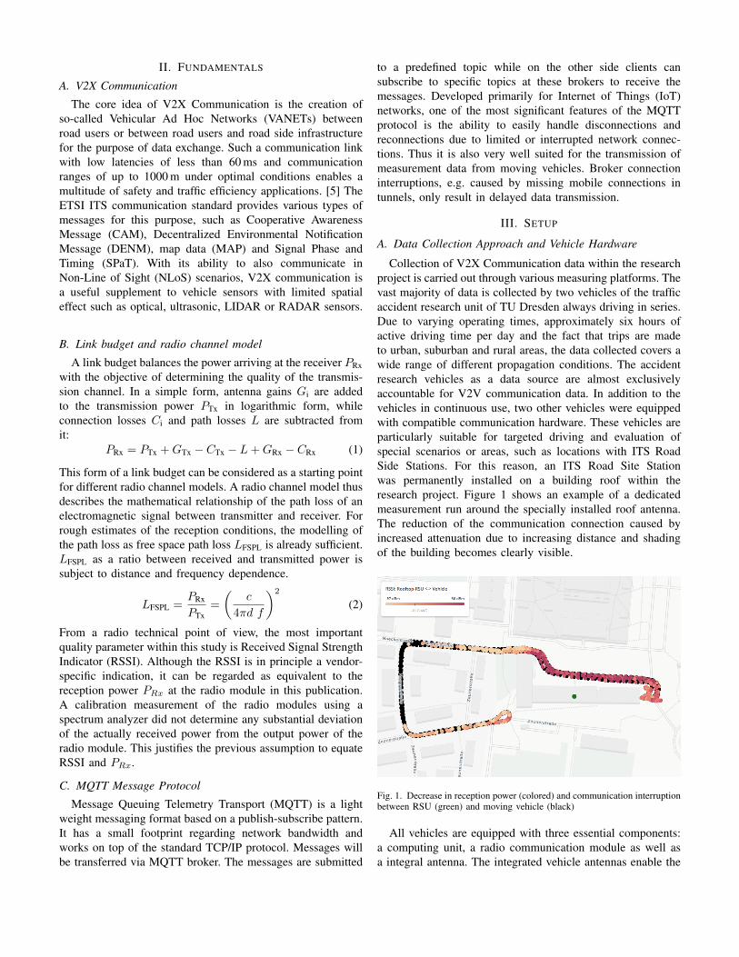
Collection of V2X Communication data within the researchproject is carried out through various measuring platforms. Thevast majority of data is collected by two vehicles of the trafficaccident research unit of TU Dresden always driving in series.Due to varying operating times, approximately six hours ofactive driving time per day and the fact that trips are madeto urban, suburban and rural areas, the data collected covers awide range of different propagation conditions. The accidentresearch vehicles as a data source are almost exclusivelyaccountable for V2V communication data. In addition to thevehicles in continuous use, two other vehicles were equippedwith compatible communication hardware. These vehicles areparticularly suitable for targeted driving and evaluation ofspecial scenarios or areas, such as locations with ITS RoadSide Stations. For this reason, an ITS Road Site Stationwas permanently installed on a building roof within theresearch project. Figure 1 shows an example of a dedicatedmeasurement run around the specially installed roof antenna.The reduction of the communication connection caused byincreased attenuation due to increasing distance and shadingof the building becomes clearly visible.
Fig. 1. Decrease in reception power (colored) and communication interruptionbetween RSU (green) and moving vehicle (black)
All vehicles are equipped with three essential components:a computing unit, a radio communication module as well asa integral antenna. The integrated vehicle antennas enable the
reception of ITS G5, cellular radio with 2G / 3G / 4G, GNSStechnologies and are connected to the V2X communicationmodule. This communication module is connected via Ethernetto an automotive grade computing unit and transmits receivedITS G5 messages to it. The used communication moduleCohda Wireless MK5 (Rev. 2.00) comes with an Global Nav-igation Satellite System (GNSS) chipset with integrated deadreckoning functionality (ublox NEO-M8U). This circumstancepromises a robust position accuracy even if the measuringvehicles are located in areas without GNSS reception, e.g.tunnels or urban canyons.
B. Raw Measurement Data
The recorded raw data can be divided into the domainsof radio parameters and geographical referencing parameters.Exemplary measured values are shown in Table 1. A uniquetime stamp serves as an identifier for individual log lines.
TABLE IExemplary Raw Data
Value Example value Additional noteTIME 1548074554 unix timestamp
ID 1377 collector IDRSSI -53 dBm [23dBm; -97dBm]TYPE CAM ETSI ITS G5 message typeLATTx 51.04648 Latitude Ego VehicleLONTx 13.707152 Longitude Ego VehicleLATRx 51.046433 Latitude Receiver VehicleLONRx 13.706518 Longitude Receiver Vehicle
C. Backend Infrastructure
Data send by the vehicles arrives in telemetry servers thatbundle all data messages of all connected vehicle and forwardthe data messages to a data warehouse and big data platform.Telemetry servers utilize the MQTT protocol (see II-C) forreceiving and forwarding data messages. These servers canalso be used as edge cloud servers when placed near theinfrastructure serving the geographically nearest vehicles.The big data platform consists of two server clusters, eachcontaining at least three servers. The general structure followsthe lambda architecture. [6] The first server cluster is respon-sible for data ingestion, the speed layer and storing filter data.The second cluster is responsible for storing raw data, batchlayer and the serving layer. The general structure is depictedin Fig. 2.A MQTT broker is installed on each cluster server for thepurpose of data ingestion. So each telemetry server can chooseone of the cluster servers for submitting data messages, de-pending on availability of the servers. This increases the over-all system availability as the loss of one cluster server does notstop data processing. On the speed level cluster Apache Kafkais used to manage data streams. A Kafka Connect module isresponsible for transforming incoming MQTT messages intodata streams. Depending on the MQTT topic, the messages areforwarded to two streams, one for batch processing and onefor stream processing. The stream processing is implemented
as Kafka Streams applications and main goal is to evaluatethe positions of the vehicles. The applications determine thestatus of the vehicles (moving/parking) and perform a Hidden-Markov-based map matching to estimate the road wherethe vehicles are driving. This results in the OpenStreetMap(OSM)-id of the current road section. The data derived fromthe streaming applications is stored in an Apache Cassandradatabase and is reused to filter raw data. The cluster for thebatch layer is a classic Apache Hadoop setup. It stores rawdata and gives access for analytic evaluation of data. The radiopropagation models are developed and tested within this unit.Within the research project it has proved to be advantageousto encapsulate developed propagation models with the helpof the container environment Docker and to equip it witha dedicated Application Programming Interface (API). Thisensures a relatively high portability of the models as well asthe interface, which can be executed on different instances.For example, the container can easily be started on a businessplatform to serve various use cases for end customers.
Streamprocessing
Batchprocessing
Rawdata
Filterdata
Business Plattform
Channelmodel
Telemetryserver
Fig. 2. Overview on the system architecture
D. Reverse Geocoding and Feature Engineering
In general, the term reverse geocoding (or inverse geocod-ing) describes searching and finding of mostly textual locationinformation for existing coordinates. This process forms thebasis for further data analysis with previously unknown at-tributes (”data mining”). This study primarily uses the opensource database OSM as an additional source for geograph-ically referenced data. Reverse geocoding functions includethe determination of the OSM road type for the respectivepositions of transmitter and receiver vehicle, as well as thedetermination of the Line of Sight (LoS) or NLoS conditions.The determination of OSM road type is realized by addingthe attribute of the OSM line element closest to the coordinate
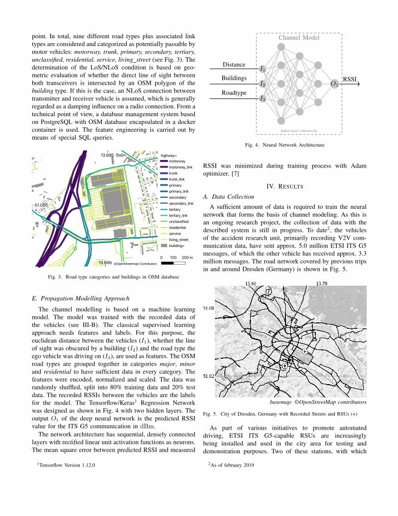
point. In total, nine different road types plus associated linktypes are considered and categorized as potentially passable bymotor vehicles: motorway, trunk, primary, secondary, tertiary,unclassified, residential, service, living street (see Fig. 3). Thedetermination of the LoS/NLoS condition is based on geo-metric evaluation of whether the direct line of sight betweenboth transceivers is intersected by an OSM polygon of thebuilding type. If this is the case, an NLoS connection betweentransmitter and receiver vehicle is assumed, which is generallyregarded as a damping influence on a radio connection. From atechnical point of view, a database management system basedon PostgreSQL with OSM database encapsulated in a dockercontainer is used. The feature engineering is carried out bymeans of special SQL queries.
Fig. 3. Road type categories and buildings in OSM database
E. Propagation Modelling Approach
The channel modelling is based on a machine learningmodel. The model was trained with the recorded data ofthe vehicles (see III-B). The classical supervised learningapproach needs features and labels. For this purpose, theeuclidean distance between the vehicles (I1), whether the lineof sight was obscured by a building (I2) and the road type theego vehicle was driving on (I3), are used as features. The OSMroad types are grouped together in categories major, minorand residential to have sufficient data in every category. Thefeatures were encoded, normalized and scaled. The data wasrandomly shuffled, split into 80% training data and 20% testdata. The recorded RSSIs between the vehicles are the labelsfor the model. The Tensorflow/Keras1 Regression Networkwas designed as shown in Fig. 4 with two hidden layers. Theoutput O1 of the deep neural network is the predicted RSSIvalue for the ITS G5 communication in dBm.
The network architecture has sequential, densely connectedlayers with rectified linear unit activation functions as neurons.The mean square error between predicted RSSI and measured
1Tensorflow Version 1.12.0
I2
I1
I3
Distance
Buildings
RoadtypeO1
Channel Model
hidden layers schematically
RSSI
Fig. 4. Neural Network Architecture
RSSI was minimized during training process with Adamoptimizer. [7]
IV. RESULTS
A. Data Collection
A sufficient amount of data is required to train the neuralnetwork that forms the basis of channel modeling. As this isan ongoing research project, the collection of data with thedescribed system is still in progress. To date2, the vehiclesof the accident research unit, primarily recording V2V com-munication data, have sent approx. 5.0 million ETSI ITS G5messages, of which the other vehicle has received approx. 3.3million messages. The road network covered by previous tripsin and around Dresden (Germany) is shown in Fig. 5.
Fig. 5. City of Dresden, Germany with Recorded Streets and RSUs (+)
As part of various initiatives to promote automateddriving, ETSI ITS G5-capable RSUs are increasinglybeing installed and used in the city area for testing anddemonstration purposes. Two of these stations, with which
2As of february 2019
V2X communication is already taking place in a realenvironment, are also marked in Fig. 5. This includes therooftop installed RSU, specially added for the research project(see III-A). In order to obtain a certain statistical confidencefor the empirical channel model, sufficient data should beavailable over the entire value range of the input data. Atpresent, the data volume for communication connections withlong distances between transceivers respectively a rather lowRSSI is considered too insignificant. Thus, model predictionsfor long-distance communication are statistically uncertain.
B. Channel Model
The output of the neural network predicts an exponentialdistribution function of the received RSSI value as a functionof distance, as shown in Fig. 6. This corresponds to theintuitive estimation and can be interpreted as an adapted freespace path loss model (see Formula 2). In principle, theuse of machine learning methods for the development of anempirical propagation model for V2X communication seemsto be feasible.
Fig. 6. Empirical Channel Model learned by a Neural Network for roadcategories with LoS-Conditions
C. Use Cases
An application pursued within the research project is thecreation of a planning possibility for optimal positioning ofITS Roadside Stations. Embedded in an intuitive user inter-face, the use of the presented model compared to deterministicradio planning applications, e.g. using ray tracing methods, ischaracterized by its simple implementation and low resourceconsumption. This makes it particularly suitable for an initialestimation of the positioning of RSUs.
A second use case, which primarily uses the V2V propaga-tion model, assesses potentials of ETSI ITS G5 with regard tothe avoidance of traffic accidents and the reduction of accidentseverity. For this purpose, discretized driving trajectories oftwo accident participants of actual traffic accidents are evalu-ated retroactively with regard to the connection characteristicsat and before the time of the collision..
V. CONCLUSION AND FUTURE WORK
The publication presents the basic design of a big dataacquisition and processing system that uses V2X radio com-munication data from long-term measurements to generatea prototypical propagation model. The modeling is doneutilizing a Tensorflow regression network. The possibility toenrich raw data with further characteristics was demonstratedexemplarily by the characteristics road type and NLoS. Neces-sary steps and the principle feasibility of creating an empiricalV2X propagation model using machine learning methods areshown.
With the planned integration of a special measuring tram,a completely new type of measuring vehicle is also on thehorizon. The evaluation of V2X radio communication data of atrack-bound vehicle, whose local trajectory characteristics arecompletely identical due to the system, holds a high potential,especially with regard to position-independent influencingfactors. On the side of potential applications, the possibility ofan onboard prediction of the expected reception quality for aspecific vehicle is an interesting option. For this purpose, thedirect determination of the input vectors used for a concreteradio channel model by the vehicle itself would be necessary.
An obvious step to extend the existing system is to addfurther input features, which potentially influence the V2Xcommunication. In addition to the already used features dis-tance, road type and buildings, the extension by the followingfeatures is planned: tunnel environment, number of lanes,vehicle speed, interference by other transmitters, precipitationintensity, as well as time of day, month and year. Whilesome of the mentioned variables act as direct influencingfactors, e.g. additive reflections by tunnel walls, other variablesare assumed to have an indirect effect on the propagationconditions. This applies, for example, to the time of day.During peak traffic hours, traffic density usually increases andso does the number of vehicles causing NLoS connections.Qualification and quantification of the individual influencingfactors are of scientific relevance on the way to a morenetworked mobility.
REFERENCES
[1] T. Frankiewicz, A. Hinsberger, T. Lorenz, H.-J. Hilt, S. Weber, H. Wieker,and F. Koster, “Standortbestimmung und integration von its roadsidestations fur die anwendungsplattform intelligente mobilitat,” AAET-Automatisierungssysteme, Assistenzsysteme und eingebettete Systeme furTransportmittel, vol. 9, no. 10.02, 2011.
[2] L. Cheng, B. E. Henty, D. Stancil, F. Bai, and P. Mudalige, “Mobilevehicle-to-vehicle narrow-band channel measurement and characterizationof the 5.9 ghz dedicated short range communication (dsrc) frequencyband,” Selected Areas in Communications, IEEE Journal on, vol. 25, pp.1501 – 1516, 11 2007.
[3] I. Sen and D. Matolak, “Vehiclevehicle channel models for the 5-ghzband,” IEEE Transactions on Intelligent Transportation Systems, vol. 9,pp. 235–245, 06 2008.
[4] A. F. Molisch, F. Tufvesson, J. Karedal, and C. Mecklenbruker, “A surveyon vehicle-to-vehicle propagation channels,” Wireless Communications,IEEE, vol. 16, pp. 12 – 22, 01 2010.
[5] D. Eckhoff, N. Sofra, and R. German, “A performance study of cooper-ative awareness in etsi its g5 and ieee wave,” in 2013 10th Annual Con-ference on Wireless On-demand Network Systems and Services (WONS),March 2013, pp. 196–200.
[6] Z. Hasani, M. Kon-Popovska, and G. Velinov, “Lambda architecture forreal time big data analytic,” ICT Innovations, pp. 133–143, 2014.
[7] D. P. Kingma and J. Ba, “Adam: A method for stochasticoptimization,” CoRR, vol. abs/1412.6980, 2014. [Online]. Available:http://arxiv.org/abs/1412.6980