40
1 JPSS Calibration/Validation Maturity Review Validated Maturity Science Review for VIIRS Polar Winds Presented by Jeff Key and Jaime Daniels Date: 18 October 2016

1 JPSS Calibration/Validation Maturity Review
Validated Maturity Science Review
for VIIRS Polar Winds
Presented by Jeff Key and Jaime Daniels
Date: 18 October 2016

2 JPSS Calibration/Validation Maturity Review
VIIRS Polar Winds (VPW) in Brief
VIIRS Polar Winds are derived
by tracking clouds features in the
VIIRS longwave infrared channel
(Band M15, 10.8um)
• Wind speed, direction, and height are measured throughout the troposphere, poleward of approximately 65 degrees latitude, in cloudy areas only
• Wind information is generated in both the Arctic and Antarctic regions
• The product includes observation time, data quality flags, and metadata

3 JPSS Calibration/Validation Maturity Review
Previous Reviews and Current Status
• Critical design review for VIIRS Polar Winds – April 27, 2011
• Algorithm Readiness Review/Maturity Review – March 27, 2014
• The VIIRS Polar Winds product has been operational since May
2014.
• VPW is also generated at direct broadcast sites and delivered to
NWP centers.
• Algorithm changes since ARR: none

4 JPSS Calibration/Validation Maturity Review
Name Organization Major Task
Jeff Key STAR Project management, DB winds
Jaime Daniels STAR Project management, algorithm
development and testing
Wayne Bresky IMSG Algorithm development and testing
Andrew Bailey IMSG Algorithm development and testing
Dave Santek CIMSS Algorithm and product testing
Steve
Wanzong
CIMSS Algorithm and product testing
Hongming Qi OSPO Operations
Walter Wolf
and others
STAR, AIT Implementation
VIIRS Polar Winds Team

5 JPSS Calibration/Validation Maturity Review
Requirements
JPSS L1RD supplement (threshold) requirements versus observed
Attribute Threshold Observed/validated
Geographic coverage ~70o latitude to poles ~65o to poles
Vertical Coverage Surface to tropopause same
Vertical Cell Size At cloud tops same
Horizontal Cell Size 10 km (should be
~19 km, CCR Aug 2015)
same
Mapping Uncertainty 0.4 km (nadir); 1.5km (edge
of scan)
0.57 km
Measurement Range Speed: 3 to 100 m s-1;
Direction: 0 to 360 degrees
same
Measurement Accuracy Mean vector difference: 7.5
m/s
5.7-7.0 m/s (w/raobs)
Measurement Precision Mean vector difference: 4.2
m/s (was 3.8 m/s)
2.7-3.8 m/s (w/raobs)
Measurement
Uncertainty
Not specified Not applicable
6 JPSS Calibration/Validation Maturity Review
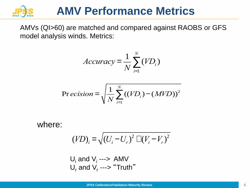
AMV Performance Metrics
Accuracy =1
N(VDi
i=1
N
å )
Pr ecision =1
N((VDi
i=1
N
å )- (MVD))2
where:
(VD)i = (Ui -Ur )2 + (Vi -Vr )
2
Ui and Vi ---> AMV
Ur and Vr ---> “Truth”
AMVs (QI>60) are matched and compared against RAOBS or GFS
model analysis winds. Metrics:

7 JPSS Calibration/Validation Maturity Review
JERD Requirements
JPSS ESPC Requirements Document (JERD) requirements:
Requirement
ID Requirement Text
JERD-2139 The algorithm shall produce a polar winds product that has
vertical coverage from the surface to the tropopause.
JERD-2140 The algorithm shall produce a polar winds product that has a
horizontal resolution of 10 km.
JERD-2141 The algorithm shall produce a polar winds product that has a
vertical reporting interval at cloud tops.
JERD-2142 The algorithm shall produce a polar winds product that has a
mapping uncertainty (3 sigma) of 5 km.
JERD-2143
The algorithm shall produce a polar winds product that has a
measurement range of:
3 to 100 m/sec for speed and
0 to 360 degrees for direction.
JERD-2144 The algorithm shall produce a polar winds product that has a
measurement precision mean vector difference of 3.8 m/sec.
JERD-2145 The algorithm shall produce a polar winds product that has a
measurement accuracy mean vector difference of 7.5 m/sec.

8 JPSS Calibration/Validation Maturity Review
Validation Strategy
• Derive winds over both poles using overlapping NPP/VIIRS orbits
• Derive winds with full product precedence in place – Official NPP cloud mask product is used
– Cloud Products (cloud-top temp, pressure, phase, type) are
generated as part of the product precedence chain
• Collocate (in space and time) derived satellite winds with
reference (“truth”) winds – Radiosonde wind observations (Land)
– Aircraft wind observations (Land & Ocean)
– GFS analysis winds (Ocean)
• Generate comparative statistics (satellite winds minus reference
winds) – Accuracy
– Precision

9
Derived Motion Winds Test Plan –
Offline Validation: Truth Data
• Radiosonde wind observations serve as a
key validation data source for derived
motion wind products
• Used by all operational satellite
processing centers that generate
satellite derived motion winds
• Aircraft wind observations
• GFS Model Analysis Wind Fields

Comparison statistics of VPW product computed using the M15 band (10.76um),
10
All Levels
(100-1000 hPa)
VIIRS Polar Wind vs. Radiosonde
Winds (m/s)
GFS Forecast Winds vs. Radiosonde
Winds (m/s) NHEM SHEM NHEM SHEM
Accuracy 5.67 5.71 4.54 4.77
Precision 3.41 3.25 3.06 2.99
Speed bias 0.38 -0.04 -0.30 -0.57
Speed 17.61 14.22 16.93 13.69
Sample 9650 866 9650 866
High Level
(100-400 hPa) NHEM SHEM NHEM SHEM
Accuracy 6.21 6.81 5.08 5.56
Precision 3.55 3.36 3.23 3.14
Speed bias -0.06 -0.23 -0.69 -0.55
Speed 23.62 18.05 22.99 17.73
Sample 3054 301 3054 301
Mid Level
(400-700 hPa) NHEM SHEM NHEM SHEM
Accuracy 5.65 5.24 4.48 4.48
Precision 3.40 3.12 3.04 2.87
Speed bias 0.56 0.07 -0.32 -0.75
Speed 16.69 12.51 15.81 11.69
Sample 4468 471 4468 471
Low Level
(700-1000 hPa) NHEM SHEM NHEM SHEM
Accuracy 4.95 4.55 3.90 3.70
Precision 3.08 2.39 2.69 2.40
Speed bias 0.64 0.04 0.32 0.28
Speed 10.91 10.52 10.58 10.76
Sample 2128 94 2128 94
Comparisons to Radiosondes
September, 2013 – January, 2014
Measurement
Accuracy 7.5 m/s
Measurement
Precision 3.8 m/s
Specifications:
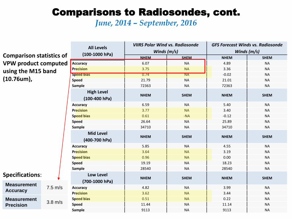
Comparison statistics of VPW product computed using the M15 band (10.76um),
11
All Levels
(100-1000 hPa)
VIIRS Polar Wind vs. Radiosonde
Winds (m/s)
GFS Forecast Winds vs. Radiosonde
Winds (m/s) NHEM SHEM NHEM SHEM
Accuracy 6.07 NA 4.89 NA
Precision 3.75 NA 3.36 NA
Speed bias 0.74 NA -0.02 NA
Speed 21.79 NA 21.01 NA
Sample 72363 NA 72363 NA
High Level
(100-400 hPa) NHEM SHEM NHEM SHEM
Accuracy 6.59 NA 5.40 NA
Precision 3.77 NA 3.40 NA
Speed bias 0.61 -NA -0.12 NA
Speed 26.64 NA 25.89 NA
Sample 34710 NA 34710 NA
Mid Level
(400-700 hPa) NHEM SHEM NHEM SHEM
Accuracy 5.85 NA 4.55 NA
Precision 3.64 NA 3.19 NA
Speed bias 0.96 NA 0.00 NA
Speed 19.19 NA 18.23 NA
Sample 28540 NA 28540 NA
Low Level
(700-1000 hPa) NHEM SHEM NHEM SHEM
Accuracy 4.82 NA 3.99 NA
Precision 3.62 NA 3.44 NA
Speed bias 0.51 NA 0.22 NA
Speed 11.44 NA 11.14 NA
Sample 9113 NA 9113 NA
Comparisons to Radiosondes, cont.
June, 2014 – September, 2016
Measurement
Accuracy 7.5 m/s
Measurement
Precision 3.8 m/s
Specifications:

Comparison of the
VPW product with
aircraft data.
There were insuffient
data from the Southern
Hemisphere for reliable
statistics for different
height bins.
12
All Levels
(100-1000 hPa)
VIIRS Polar Wind
vs. Aircraft
Winds (m/s)
VIIRS Polar Wind
vs. Aircraft
Winds (m/s) NHEM SHEM
Accuracy 6.10 7.02
Precision 3.27 2.74
Speed bias 0.36 -0.98
Speed 18.76
Sample 3225 81
High Level
(100-400 hPa) NHEM NHEM
Accuracy 6.56
Precision 3.36
Speed bias -0.34
Speed 20.24
Sample 2082
Mid Level
(400-700 hPa) NHEM NHEM
Accuracy 5.37
Precision 3.22
Speed bias 1.57
Speed 17.37
Sample 945
Low Level
(700-1000 hPa) NHEM NHEM
Accuracy 4.77
Precision 2.00
Speed bias 1.93
Speed 9.81
Sample 198
Comparisons to Aircraft
January 29, 2014 – February 23, 2014
Measurement
Accuracy 7.5 m/s
Measurement
Precision 3.8 m/s
Specifications:
Comparisons of the algorithm’s derived winds against raob and aircraft winds at all levels (100-1000 hPa), high level (100- 400 hPa), mid level (400-700 hPa), and low level (700-100 hPa) in the northern hemisphere. In each case, the observed precision meets the requirement. The accuracy and precision of the VIIRS winds fall well within the accuracy and precision specifications.

Comparison of the
VPW product with
aircraft data.
There were insuffient
data from the Southern
Hemisphere for reliable
statistics for different
height bins.
13
All Levels
(100-1000 hPa)
VIIRS Polar Wind
vs. Aircraft
Winds (m/s)
VIIRS Polar Wind
vs. Aircraft
Winds (m/s) NHEM SHEM
Accuracy 5.77 6.77
Precision 3.56 3.83
Speed bias 1.08 -1.67
Speed 21.62 29.97
Sample 34998 354
High Level
(100-400 hPa) NHEM SHEM
Accuracy 6.48 6.77
Precision 3.70 3.83
Speed bias 0.45 -1.67
Speed 27.27 29.97
Sample 14781 354
Mid Level
(400-700 hPa) NHEM SHEM
Accuracy 5.50 NA
Precision 3.64 NA
Speed bias 1.52 NA
Speed 19.59 NA
Sample 14775 NA
Low Level
(700-1000 hPa) NHEM SHEM
Accuracy 4.59 NA
Precision 3.04 NA
Speed bias 1.57 NA
Speed 11.75 NA
Sample 5442 NA
Comparisons to Aircraft, cont.
June, 2014 – September, 2016
Measurement
Accuracy 7.5 m/s
Measurement
Precision 3.8 m/s
Specifications:
Comparisons of the algorithm’s derived winds against raob and aircraft winds at all levels (100-1000 hPa), high level (100- 400 hPa), mid level (400-700 hPa), and low level (700-100 hPa) in the northern hemisphere. In each case, the observed precision meets the requirement. The accuracy and precision of the VIIRS winds fall well within the accuracy and precision specifications.

14
Requirement ID Requirement Text
JERD-2139 The algorithm shall produce a polar winds product that has vertical coverage from the surface to the tropopause.
• The winds derivation method is based on tracking clouds. Wind vectors are derived wherever a cloud target can be tracked. Therefore, the vertical coverage of the winds is equivalent to the vertical distribution of clouds that are tracked. Given that clouds can occur anywhere in the troposphere (and can, in fact, extend into the stratosphere), the derived wind vectors can and do occur at all vertical levels throughout the troposphere.
• The validation results tables shown earlier clearly indicate that the vertical coverage is throughout the troposphere.

15
Requirement ID Requirement Text
JERD-2140 The algorithm shall produce a polar winds product that has a horizontal resolution of 10 km.
• This requirement is not being met. The horizontal resolution is inherent in the algorithm. It is simply the size of the “target box” that is used for tracking. The target box size is 19 km, not 10 km. We believe that the 10 km value was inherited from an early GOES-R requirement and never changed. The requirement should be 19 km.
• A CCR for this item was submitted in August 2015. Its status is unknown.

16
Requirement ID Requirement Text
JERD-2141 The algorithm shall produce a polar winds product that has a vertical reporting interval at cloud tops.
• The winds derivation method is based on tracking clouds. The VIIRS and GOES-R winds algorithms use an externally-generated cloud product, which includes the cloud heights. The algorithm dictates that the height of the derived wind vector is the cloud top height. No further verification is needed.

17
Requirement ID Requirement Text
JERD-2142 The algorithm shall produce a polar winds product that has a mapping uncertainty (3 sigma) of 5 km.
• The location accuracy of the VIIRS winds is dependent upon (a) the geolocation accuracy of the SDRs, (b) the mapping accuracy of the map projection software (MODIS Swath to Grid Toolbox, MS2GT), and (c) the retransformation from line/element back to latitude/longitude (McIDAS functions).
• To quantify the overall accuracy, control points on coastlines in the VIIRS imagery used for wind retrievals were identified. Their locations were compared to a high resolution land database.
• The mean mapping error is 1.55 km with a standard deviation of 0.57 km. The 3-sigma value (3 x standard deviation) is 1.72 km.
• Mapping accuracy therefore meets the requirement of 5 km.
18
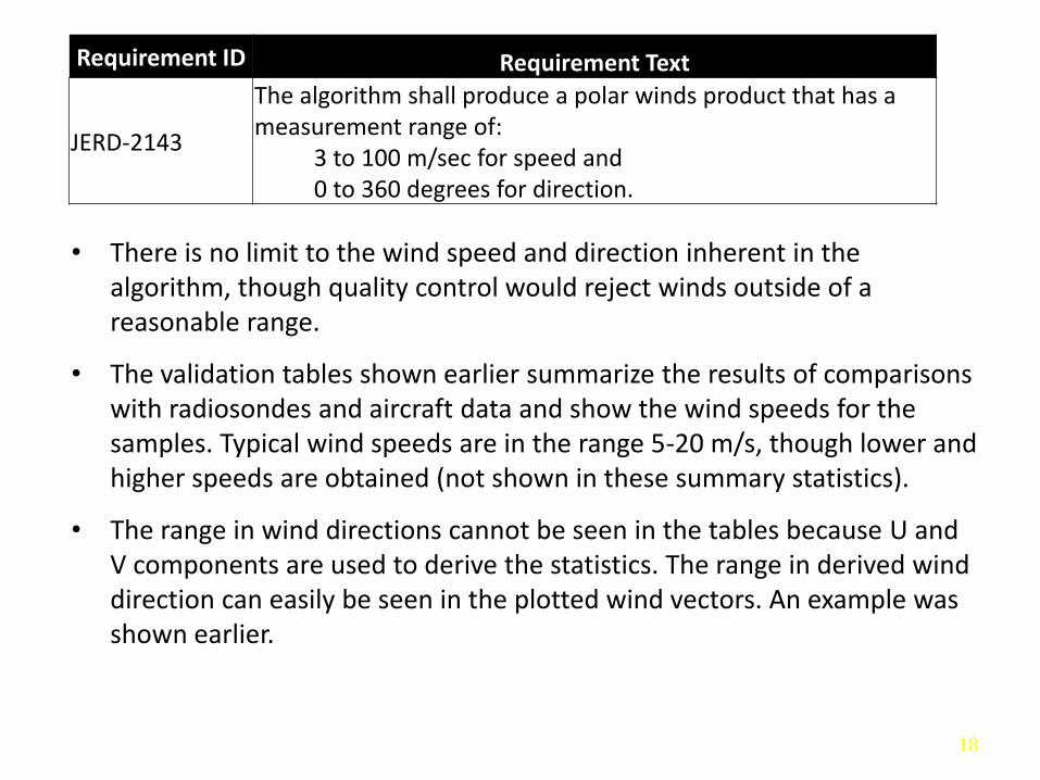
Requirement ID Requirement Text
JERD-2143
The algorithm shall produce a polar winds product that has a measurement range of: 3 to 100 m/sec for speed and 0 to 360 degrees for direction.
• There is no limit to the wind speed and direction inherent in the algorithm, though quality control would reject winds outside of a reasonable range.
• The validation tables shown earlier summarize the results of comparisons with radiosondes and aircraft data and show the wind speeds for the samples. Typical wind speeds are in the range 5-20 m/s, though lower and higher speeds are obtained (not shown in these summary statistics).
• The range in wind directions cannot be seen in the tables because U and V components are used to derive the statistics. The range in derived wind direction can easily be seen in the plotted wind vectors. An example was shown earlier.
19 JPSS Calibration/Validation Maturity Review
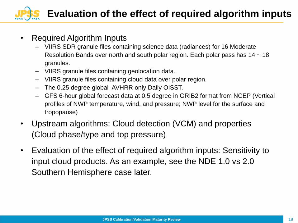
Evaluation of the effect of required algorithm inputs
• Required Algorithm Inputs – VIIRS SDR granule files containing science data (radiances) for 16 Moderate
Resolution Bands over north and south polar region. Each polar pass has 14 ~ 18
granules.
– VIIRS granule files containing geolocation data.
– VIIRS granule files containing cloud data over polar region.
– The 0.25 degree global AVHRR only Daily OISST.
– GFS 6-hour global forecast data at 0.5 degree in GRIB2 format from NCEP (Vertical
profiles of NWP temperature, wind, and pressure; NWP level for the surface and
tropopause)
• Upstream algorithms: Cloud detection (VCM) and properties
(Cloud phase/type and top pressure)
• Evaluation of the effect of required algorithm inputs: Sensitivity to
input cloud products. As an example, see the NDE 1.0 vs 2.0
Southern Hemisphere case later.

20 JPSS Calibration/Validation Maturity Review
20
All derived winds are subject to the following quality
assurance checks and are flagged if test thresholds
are exceeded
– SSD correlation check (threshold = 0.60)
– Correlation match occurs on the boundary of the search
scene
– u- and v-component acceleration checks (threshold = 10 m/s)
– Minimum speed check (threshold >= 3 m/s)
– Directional (threshold = 50 deg) and speed checks (threshold
= 8 m/s) against forecast
Quality indicators are computed and appended to
each derived wind vector
– Quality Indicator (QI)
– Expected Error (EE)
Quality Indicators
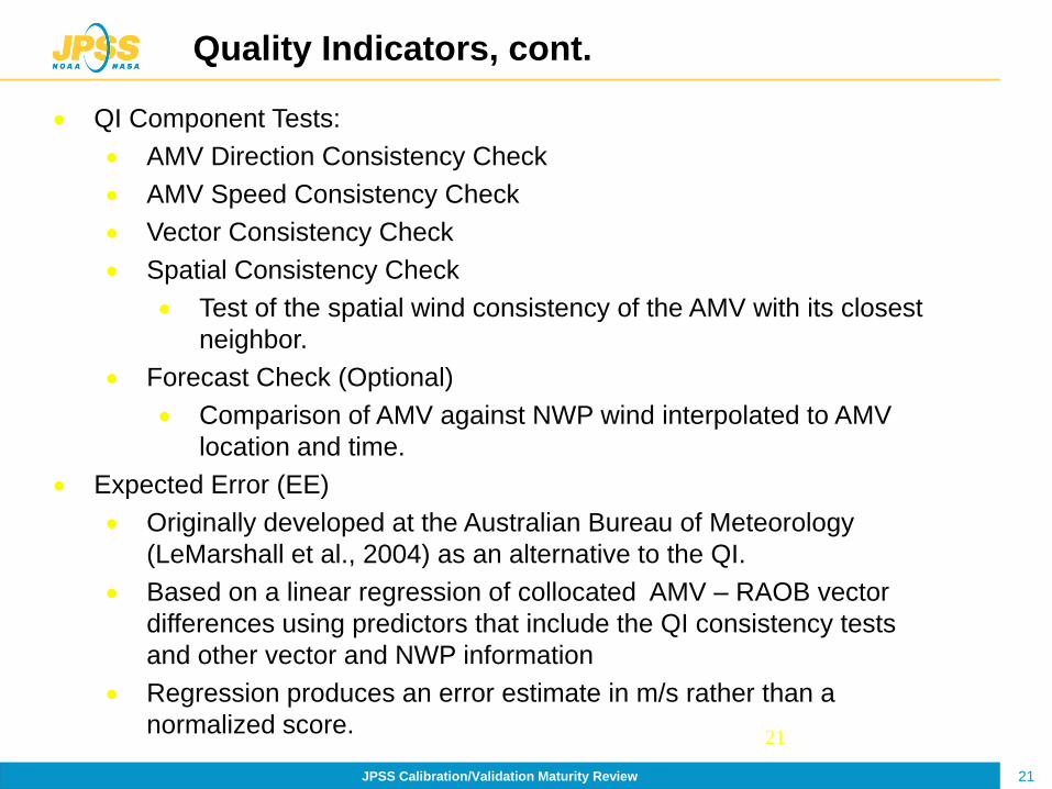
21 JPSS Calibration/Validation Maturity Review
21
Quality Indicators, cont.
QI Component Tests:
AMV Direction Consistency Check
AMV Speed Consistency Check
Vector Consistency Check
Spatial Consistency Check
Test of the spatial wind consistency of the AMV with its closest
neighbor.
Forecast Check (Optional)
Comparison of AMV against NWP wind interpolated to AMV
location and time.
Expected Error (EE)
Originally developed at the Australian Bureau of Meteorology
(LeMarshall et al., 2004) as an alternative to the QI.
Based on a linear regression of collocated AMV – RAOB vector
differences using predictors that include the QI consistency tests
and other vector and NWP information
Regression produces an error estimate in m/s rather than a
normalized score.

22 JPSS Calibration/Validation Maturity Review
22
Quality Indicators, cont.
Both the QI and EE have their strengths. The EE estimated
vector reliability values have a closer 1-to-1 relationship with
actual RMS errors measured against raobs. The QI tends to rank
more vectors as reliable, especially fast AMVs.
Both methods are used as AMV quality flags. Users can
selectively employ the flags in their local quality control.
AMVs that pass both EE and QI thresholds are kept.

23 JPSS Calibration/Validation Maturity Review
23
Exception Handling
The algorithm checks whether the time interval is valid and that the temporal data has been loaded properly.
The algorithm checks that the search region is larger than the target scene.
The algorithm checks the sensor data flags to see if channel data is valid.
If the AMV retrieval is not performed, the retrieved parameters are set to a missing value and the quality flags are set to the lowest quality value.
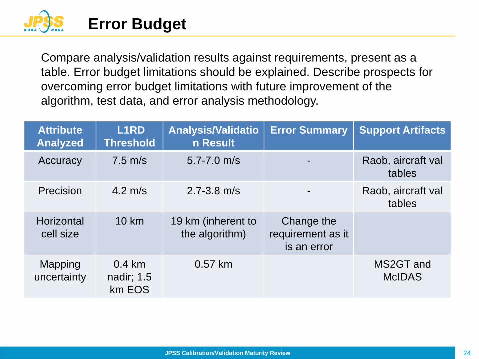
24 JPSS Calibration/Validation Maturity Review
Error Budget
Compare analysis/validation results against requirements, present as a
table. Error budget limitations should be explained. Describe prospects for
overcoming error budget limitations with future improvement of the
algorithm, test data, and error analysis methodology.
Attribute
Analyzed
L1RD
Threshold
Analysis/Validatio
n Result
Error Summary Support Artifacts
Accuracy 7.5 m/s 5.7-7.0 m/s - Raob, aircraft val
tables
Precision 4.2 m/s 2.7-3.8 m/s - Raob, aircraft val
tables
Horizontal
cell size
10 km 19 km (inherent to
the algorithm)
Change the
requirement as it
is an error
Mapping
uncertainty
0.4 km
nadir; 1.5
km EOS
0.57 km MS2GT and
McIDAS

25 JPSS Calibration/Validation Maturity Review
Identification of Processing Environment
• ESPC (e.g., NDE, Okeanos) build (version) number:
NDE 1.0 (see next slide for NDE 2.0 test)
• Algorithm version: v1r1
• Environment used to achieve validated maturity stage:
NDE 1.0

NDE 1.0 vs 2.0: Northern Hemisphere
In the NH case, the vast majority of winds (location, speed, direction, height) from NDE 1.0 and NDE 2.0 matched up exactly for the cases examined.
VIIRS Winds from NDE 1.0 VIIRS Winds from NDE 2.0 AMV Heights from NDE 1.0 AMV Heights from NDE 2.0
AMV Assigned Height
100 190 260 370 460 550 640 730 820 910 1000 (mb)
Fre
qu
en
cy
Nearly all of the yellow and red wind barbs fall exactly on top of each other. There a few red wind barbs where corresponding yellow wind barbs don’t exist, but this is not a concern.
The histograms of heights assigned to the winds in both systems agree very, very well.

NDE 1.0 vs 2.0: Southern Hemisphere
In the SH case there are more differences between the NDE 1.0 and NDE 2.0 VPW winds, which we attribute to known errors in the cloud mask.
VIIRS Winds from NDE 1.0 VIIRS Winds from NDE 2.0 AMV Heights from NDE 1.0 AMV Heights from NDE 2.0
AMV Assigned Height
Fre
qu
en
cy
Nearly all of the yellow and red wind barbs fall exactly on top of each other. There a few red wind barbs where corresponding yellow wind barbs don’t exist.
The histograms of heights assigned to the winds in both systems agree very, very well.

28 JPSS Calibration/Validation Maturity Review
Users
• 13 NWP centers in 9 countries of polar winds, most using VIIRS winds operationally
• U.S. Users:
– NCEP (Dennis Keyser)
– NRL/FNMOC (Randy Pauley)
– GMAO/JCSDA
• Foreign Users:
– UK Met Office (Mary Forsythe)
– JMA (Masahiro Kazumori)
– ECMWF (Jean-Noel Thepaut)
– DWD (Alexandar Cress)
– Meteo-France (Bruno Lacroix)
– CMC (Real Sarrazin)
– BOM (John LeMarshall)
– EUMETSAT (Simon Elliott)
– Russian Hydrometcenter (Mikhail Tsyrulnikov)
– CMA (China)

29 JPSS Calibration/Validation Maturity Review
Users, cont.
Organization Use VPW
operationally
Currently
monitoring
Plan to use?
NCEP Yes Yes (early
2017)
DWD Yes
Navy Yes
ECMWF Yes
Met Office Yes Yes
CMC Yes
MeteoFrance Yes Yes
Awaiting information from the other NWP centers.

30 JPSS Calibration/Validation Maturity Review
Users & User Feedback
• Feedback from users
– Over the last decade, model impact studies at >10 major NWP centers have demonstrated that model forecasts for the NH and SH extratropics are improved when the MODIS polar winds are assimilated. Forecasts can be extended 2-6 hrs, depending on the location.
– NWP users have reported similar results for the VIIRS Polar Winds, as reported at the most recent International Winds Workshop (2016, Monterey) and at other venues.
– Many NWP centers are either testing the VWP or using them
in their operational system.
• Downstream product list: None

31 JPSS Calibration/Validation Maturity Review
Documentation
Science Maturity Check List Yes ?
ReadMe for Data Product Users Yes
Algorithm Theoretical Basis Document (ATBD) Yes
Algorithm Calibration/Validation Plan Yes
(External/Internal) Users Manual Yes
System Maintenance Manual (for ESPC products) Yes
Peer Reviewed Publications (Demonstrates algorithm is independently reviewed)
Yes
Regular Validation Reports (at least. annually) (Demonstrates long-term performance of the algorithm)
?

32 JPSS Calibration/Validation Maturity Review
Conclusion
• Cal/Val results summary:
– Team recommends algorithm Validated Maturity
– Caveats: None
33 JPSS Calibration/Validation Maturity Review
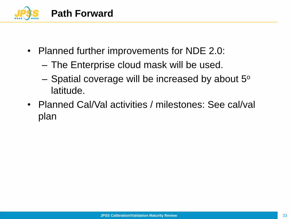
Path Forward
• Planned further improvements for NDE 2.0:
– The Enterprise cloud mask will be used.
– Spatial coverage will be increased by about 5o
latitude.
• Planned Cal/Val activities / milestones: See cal/val
plan

34 JPSS Calibration/Validation Maturity Review
Extra Slides
35 JPSS Calibration/Validation Maturity Review
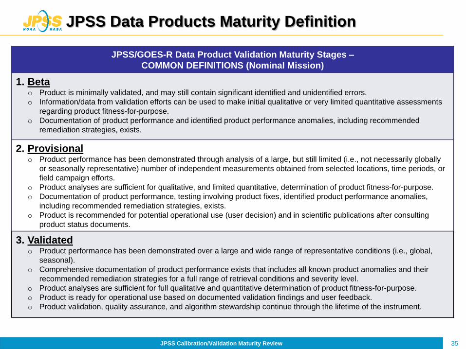
JPSS Data Products Maturity Definition
JPSS/GOES-R Data Product Validation Maturity Stages –
COMMON DEFINITIONS (Nominal Mission)
1. Beta o Product is minimally validated, and may still contain significant identified and unidentified errors.
o Information/data from validation efforts can be used to make initial qualitative or very limited quantitative assessments
regarding product fitness-for-purpose.
o Documentation of product performance and identified product performance anomalies, including recommended
remediation strategies, exists.
2. Provisional o Product performance has been demonstrated through analysis of a large, but still limited (i.e., not necessarily globally
or seasonally representative) number of independent measurements obtained from selected locations, time periods, or
field campaign efforts.
o Product analyses are sufficient for qualitative, and limited quantitative, determination of product fitness-for-purpose.
o Documentation of product performance, testing involving product fixes, identified product performance anomalies,
including recommended remediation strategies, exists.
o Product is recommended for potential operational use (user decision) and in scientific publications after consulting
product status documents.
3. Validated o Product performance has been demonstrated over a large and wide range of representative conditions (i.e., global,
seasonal).
o Comprehensive documentation of product performance exists that includes all known product anomalies and their
recommended remediation strategies for a full range of retrieval conditions and severity level.
o Product analyses are sufficient for full qualitative and quantitative determination of product fitness-for-purpose.
o Product is ready for operational use based on documented validation findings and user feedback.
o Product validation, quality assurance, and algorithm stewardship continue through the lifetime of the instrument.

36 JPSS Calibration/Validation Maturity Review
36
References
• Baum, Bryan , P. Yang, Yang, Ping; Heymsfield, Andrew J.; Platnick, Steven; King, Michael D.; Hu, Y.-X., and Bedka, Sarah T., 2005: Bulk scattering properties for the remote sensing of ice clouds, part II: Narrowband models. Journal of Applied Meteorology, Volume 44, Issue 12, pp.1896-1911.
• Coakley, J.A, and F.P. Bretherton, 1982: Cloud cover from high resolution scanner data: detecting and allowing for partially filled fields of view. J. Geophys. Res., 87, 4917− 4932.
• Dunion, J. and C. Velden, 2002: Application of Surface-Adjusted GOES Low-Level Cloud-Drift Winds in the Environment of Atlantic Tropical Cyclones. Part I: Methodology and Validation. Monthly Weather Review, Volume 130, Issue 5 pp. 1333–1346
• EUMETSAT, 2005: The EUMETSAT wind vector automatic quality control scheme. EUM/OPS/TEN/05/1747, 10 pp.[Available online at http://www.eumetsat.int/Home/Main/Publications/Technical_and_Scientific_Documentation/Technical_Notes/SP_1124282585834?l=en .
• Hamada, T., 1983: On the optimal time-interval of satellite image acquisition for operational cloud motion wind derivation. Meteorology Center of Japan Meteorological Agency Tech. Note 7, 79–87.

37 JPSS Calibration/Validation Maturity Review
37
• GOES-R GOES-R Advanced Baseline Imager (ABI) Algorithm Theoretical Basis Document For Derived Motion Winds, Version 2.0, Sept 30, 2010
• Hansen, M., R. DeFries, J.R.G. Townshend, and R. Sohlberg (1998), UMD Global Land Cover Classification, 1 Kilometer, 1.0, Department of Geography, University of Maryland, College Park, Maryland, 1981-1994.
• Holmlund, Kenneth. The utilization of statistical properties of satellite-derived atmospheric motion vectors to derive quality indicators. Weather and Forecasting, Volume 13, Issue 4, December 1998, pp.1093-1104.
• Holmlund, Kenneth; Velden, Christopher S. and Rohn, Michael. Enhanced automated quality control applied to high-density satellite-derived winds. Monthly Weather Review, Volume 129, Issue 3, 2001, pp.517-529.
• Jedlovek, G. and R. Atkinson, 1998: The Marshall automated wind algorithm: Error analysis, quality control and climate applications. Proceedings 3rd International Winds Workshop, Saanenmoser, Switzerland, pp. 247-254.
• Key, J., D. Santek, C.S. Velden, N. Bormann, J.-N. Thepaut, L.P. Riishojgaard, Y. Zhu, and W.P. Menzel, 2003, Cloud-drift and Water Vapor Winds in the Polar Regions from MODIS, IEEE Trans. Geosci. Remote Sensing, 41(2), 482-492.
References

38 JPSS Calibration/Validation Maturity Review
38
• LeMarshall, J. A., A. Rea, L. Leslie, R. Seecamp, and M. Dunn, 2004: Error characterization of atmospheric motion vectors. Aust. Meteor. Mag., 53, 123-131
• Menzel, W.P., 1996: Report from the working group on verification statistics. Proceedings 3rd International Winds Workshop, Ascona, Switzerland, 10-12 June 1996, Pages 17-19.
• Merrill, R.T., 1989: Advances in the automated production of wind estimates from geostationary satellite imagery. Preprints, Fourth Conf. on Satellite Meteorology and Oceanography, San Diego, CA , Amer. Meteor. Soc., 246−249.
• Merrill, R.T., W. P. Menzel, W. Baker, J. Lynch, and E. Legg, 1991: A report on the recent demonstration of NOAA’s upgraded capability to derive cloud motion satellite winds. Bull. Amer. Meteor. Soc., 72, 372–376.
• Minnis P., P. Heck, D. Young, C. Fairall, and J. Snider, 1992: Stratocumulus cloud properties derived from simultaneous satellite and island-based instrumentation during FIRE. J. Appl. Meteor., 31, 317-339.
• Nieman, S.J., J. Schmetz, and W.P. Menzel, 1993: A comparison of several techniques to assign heights to cloud tracers. J. Appl. Meteor., 32, 1559−1568.
References
39 JPSS Calibration/Validation Maturity Review
39
• Otkin, J. A., D. J. Posselt, E. R. Olson, H.-L. Huang, J. E. Davies, J. Li, and C. S. Velden, 2007. Mesoscale numerical weather prediction models used in support of infrared hyperspectral measurements simulation and product algorithm development. J. Atmospheric and Oceanic Tech., 24, 585-601.
• Ottenbacher, A., M. Tomassini, K. Holmlund, and J. Schmetz, 1997: Low-Level Cloud Motion Winds from Meteosat High-Resolution Visible Imagery. Weather and Forecasting Volume 12, Issue 1, pp. 175–184
• Rossow, W.B., F. Mosher, E. Kinsella, A. Arking, M. DeBois, E. Harrison, P. Minnis, E. Ruprecht, G. Seze, C. Simmer, and E. Smith, 1985: ISCCP cloud algorithm intercomparison. J. Climate Appl. Meteor., 24, 877−903.
• Schmit, T., Gunshor, M., Menzel, W., Gurka, J., Li, J., and Bachmeier, A., (2005) Introducing the next-generation advanced baseline imager on GOES-R. Bull. Amer. Meteor. Soc., Volume 86, Issue 8, pp 1079-1096.
• Shenk, W. E., 1991: Suggestions for improving the derivation of winds from geosynchronous satellites. Global Planet. Change, 4, 165–171.
References
40 JPSS Calibration/Validation Maturity Review
40
• Velden, C.S., and K.M. Bedka, 2008: Identifying the Uncertainty in Determining Satellite-Derived Atmospheric Motion Vector Height Assignments. Conditionally accepted in J. Appl. Meteor.
• Velden, C., J. Daniels, D. Stettner, D. Santek, J. Key, J. Dunion, K. Holmlund, G. Dengel, W. Bresky, W.P. Menzel, 2005: Recent innovations in deriving tropospheric winds from meteorological satellites. Bull. Amer. Meteor. Soc., 86, 205-221.
• Velden, C., D. Stettner, and J. Daniels, 2000: Wind vector fields derived from GOES rapid-scan imagery. Proc.10th Conf. on Satellite Meteor. and Oceanography., Long Beach California, Amer. Meteor. Soc., 20–23.
References


