AN ARCHAEOLOGICAL INVESTIGATION OF THE GALENE LAKES AREA IN THE SKAGIT RANGE OF THE NORTH CASCADE MOUNTAINS, SKAGIT VALLEY PARK, BRITISH COLUMBIA Ian Christian Franck B.A., University of Alberta, 1989 THESIS SUBMITTED iN PARTIAL FULFILLMENT OF THE REQUIREMENTS FOR THE DEGREE OF MASTER OF ARTS in îhe Department of Archaeology O Ian C. Franck 2000 SIMON FRASER UNIVERSITY Apd 2000 Al1 rights reserved. This work rnay not be reproduced in whole or par?, by photocopy or other means, without permission of the author.
Transcript
AN ARCHAEOLOGICAL INVESTIGATION OF THE GALENE LAKES
AREA IN THE SKAGIT RANGE OF THE NORTH CASCADE MOUNTAINS,
SKAGIT VALLEY PARK, BRITISH COLUMBIA
Ian Christian Franck
B.A., University of Alberta, 1989
THESIS SUBMITTED iN PARTIAL FULFILLMENT OF
THE REQUIREMENTS FOR THE DEGREE OF
MASTER OF ARTS
in îhe
Department of Archaeology
O Ian C. Franck 2000
SIMON FRASER UNIVERSITY
A p d 2000
Al1 rights reserved. This work rnay not be reproduced in whole or par?, by photocopy or other means,
without permission of the author.
N a t i 0 ~ l Library 1+1 of Canada BiMiothëque nationale du Canada
Acquisitions and Acquisitions et Bi bliograp hic Services services bibliographiques
395 Wellington Street 395. r w Wdlingtm OaawaON K l A W OcrawaûN K1A ON4 cana& CaMda
The author has granted a non- exclusive Licence allowing the National Library of Canada to reproduce, loan, distribute or seil copies of this thesis in microform, paper or electronic formats.
L'auteur a accordé une licence non exclusive permettant à la Bibliothèque nationale du Canada de reproduire, prêter, distribuer ou vendre des copies de cette îhèse sous la forme de microfiche/film, de reproduction sur papier ou sur format électronique.
The author retains ownership of the L'auteur conserve la propriété du copyright in this thesis. Neither the droit d'auteur qui protège cette thèse. thesis nor substantial extracts fiom it Ni la thèse ni des extraits substantiels may be printed or otherwise de celle-ci ne doivent être imprimés reproduced without the author's ou autrement reproduits sans son permission. autorisation.
ABSTRACT
This thesis is the product of two field seasons (1997 and 1998) spent in Skagit Valley
Provincial Park in the vicinity of the Galene Lakes. The primary objective of the thesis was to
detemine the extent of precontact use of mountainous areas through an intensive survey of a
relatively small area (-1000 ha). It hopes to dispel a general belief that such areas were
marginal to cultures which are best known for their maritime and riverine oriented economic
strategies. A second objective was to provide rnethodological suggestions for working in these
difficult environments. The third and final objective was to formulate a land-use mode1 for the
precontact use of rnountainous areas in order to provide insight for future researchers.
Background research indicates that site distribution and discovery in the study area is
complicated by a shifting treeline correlated with changes in climate through time. Sites which
were originally created in a subalpine parkland setting may now be obscured today by heavy
subalpine tree cover; depending on the time period of the site this rnay even be reversed.
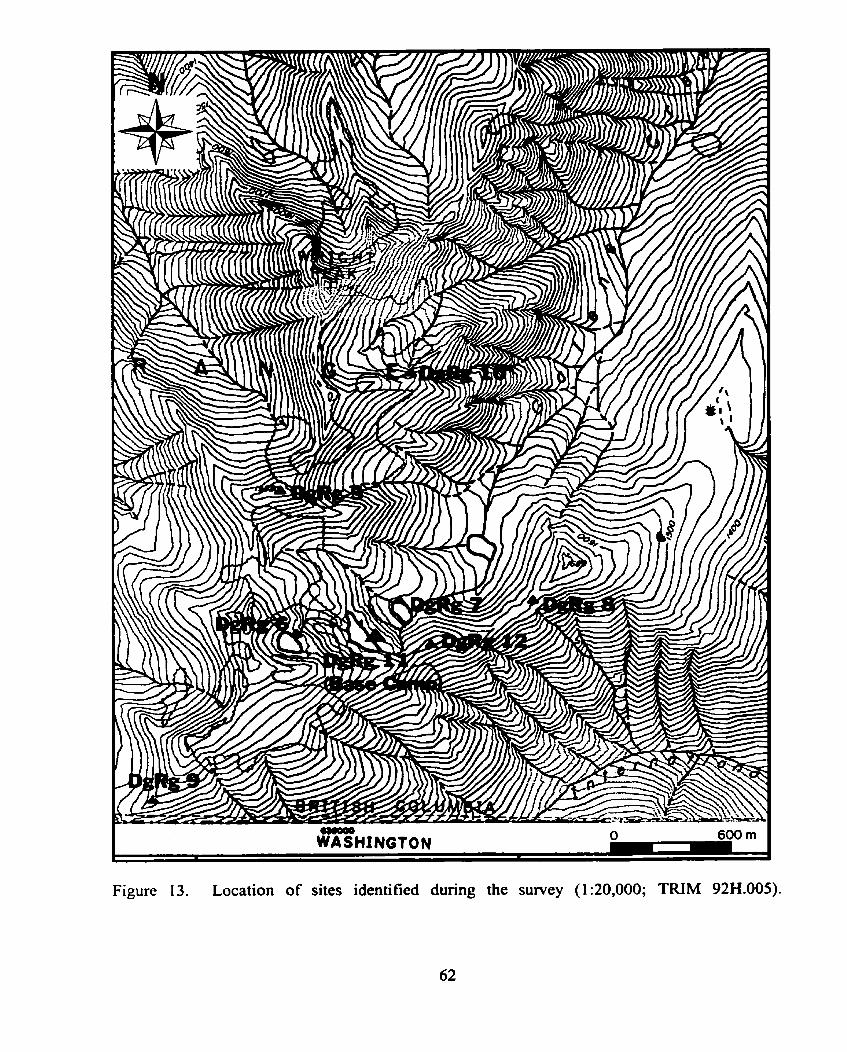
A total of eight new sites were identified during the survey. Site types represented
include solitary flakes of Hozomeen Chert (DgRg 5 and DgRg lSj, a lithic scatter @gRg 1 l), a
solitary projectile poirit midsection (DgRg 7), a quarry of Hozomeen Chert (DgRg IO), probable
huckleberry processing trenches (DgRg 8 and DgRg 9), and an historic hunting camp (DgRg 6).
Culturally modified trees are represented at Site DgRg 9 (berry trench site), and also at DgRg 6
(historic camp). Historic components are found at Sites DgRg 8 ( b e y trench site) and DgRg 1 I
(lithic scatter site).
The huckleberry processing trenches recorded during the survey represent the first such
features recorded in Canada. Previously these have been documented only in south-central
Washington State.
All sites recorded appear to be associated with a network of trajls focussed around
prominent ndgelines, not necessanly close to permanent water. This suggests that the people
who used this area were highly mobile and familiar enough with the areas' resources to risk
venturing away from life-sustaining water in order to perfom tasks. The short working season
in high elevation areas wouId have required a intimate knowledge of the resources available in
order to extract them with the necessary haste.
ACKNOWLEDGMENTS
1 would like to thank al1 who were involved in this project directly or indirectly. Foremost I
thank Rick Alexander who acted as my field assistant for two grueling seasons in the snow, sleet,
wind, and rain which make mountaintops such unique survey areas. My wife Mary DePaoli who
understands and appreciates that 1 need to do things the hard way and is my peremial champion
and soul-rnate. Kelly Bush for the original inspiration for the project. Bob Mierendorf for his
energy and expertise. Dana Lepofsky for allowing me to stick to an erratic schedule. Cheryl
Mack for showing me what a berry trench looks like. Dave Schaepe and Heather Myles who
coordinated rny permit on behalf of St8:lô Nation. Jim Wiebe and Doug Wilson for coordinating
my permit on behalf of BC Parks. Steve Acheson for acting as rny Project Officer on behalf of
the Archaeology Branch. Finally, 1 thank those responsible for setting apart the wilderness of
Skagit Valley and the North Cascades; the plants and animals which allowed me to have a
gIimpse of their world; and mountaintops everywhere.
TABLE OF CONTENTS
Approval page ............................ ..., .......................................................................................... ii ... Abstract .......................................................................................................................................................... 111
Acknowledgments .......................................................................................................................................... iv Table of Contents ............................................................................................................................................ v List of Tables ............................ ..................................................................................................................... vi .. List of Figures ............................................................................................................................................... v II
2.0 ARCHAEOLOGICAL STUDIES ZN MOLTNTAiNOUS AREAS .......................................................... 4 Upland Archaeology in British Columbia ..................................................................................... 6 2.1 . 1 The Chilliwack Forest District ............................................................................................... - 7 Previous Archaeological Studies ....................................................................................................... 8
......... . .............................................. 2.2.1 Archaeologv in North Cascades Park WA ..,, 10 2.2.2 ArchaeoIow in Skagit Vallev Park . B.C. .............................................................................. i3 - . -
............................................................. MOGRAPHY AND HISTORY OF THE STUDY AREA 21 Ethnography .................................................................................................................................... 21 3.1.1 The Lower Nlaka'~amwc ...................................................................................................... 22 3.1 -2 The U ~ p e r Sto:lô ................................................................................................................ 25
....................................................................................................................... 3.1 -3 The Nooksack 27 3.1 -4 The U D D ~ ~ Skagit .............................................................................................................. 28
3.2 Animal Use .................................................................................................................................... 30 3.3 Plant Use ........................................................................................................................................ 33
....................................................................................................... 3.4 Other Uses of Mountain Areas 39 .................................................................................................................. 3.5 Euro-Amencan History 40
4.0 Physical Environment of Study Area ..................................................................................................... 43 4.1 Geomorphology and Geology ......................................................................................................... 44
6.0 Sunfey Results ........................................................................................................................................ 60 6.1 Site DgRg5 ..................................................................................................................................... 61 6.2 Site DgRg 6 ..................................................................................................................................... 64 6.3 Site DgRg 7 ..................................................................................................................................... 67 6.4 Site DgRg 8 ..................................................................................................................................... 68 6.5 Site DgRg9 ..................................................................................................................................... 71 6.6 SiteDgRg I O ................................................................................................................................... 75 6.7 Site DgRg 1 I .................................................................................................................................. 77 6.8 Site DgRg 12 ................................................................................................................................... 81
7.0 A Model for Mountain Use of the Snidy Area ....................................................................................... 83
.................................................................................................................................................. B ib l iography 90
LIST OF TABLES
Table 1 . Previous upland work in southern British Columbia and Washington State ........ 9 ..................................................... Table 2 . Methods and possible residues fiom hunting 32
Table 3 . Subalpine and alpine plants, their uses, seasonai availability, and archaeological residue ............................................................................... 35
Table 4 . Sites identified during the survey of the Galene Lakes area ............................... 60 ........................... Table 5 . Harvest times o f plant and animal resources in the study area 86
LIST OF FIGURES
.............................................................................................. Figure 1 . Study area location 2 Figure 2 . Mountain schematic showing the location of zones mentioned in text ............... 4
....... Figure 3 . Survey distribution in British Columbia according to biogeoclimatic zone 7 .......... Figure 4 . Land distribution in British Columbia according to biogeoclimatic zone 7
.......................................... Figure 5 . Survey distribution in the Chilliwack Forest District 8 Figure 6 . Land distribution in the Chilliwack Forest District ............................................. 8
..................................... Figure 7 . Location of thesis study are in relation to major parks 11 Figure 8 . Sites recorded in Skagit Valley Provincial Park ............................................... 14 Figure 9 . Location of selected sites in the upper Fraser Valley and lower
............................................................................................ Fraser Canyon 1 9 Figure 10 . Traditional tenitories of First Nations mentioned in the text .......................... 23 Figure 1 1 . Study area showing areas intensively covered dunng the survey as well as
the routes most ofien followed ......................................................................... 54 Figure 12 . Study area showing the distribution of alpine, subalpine parkland, and
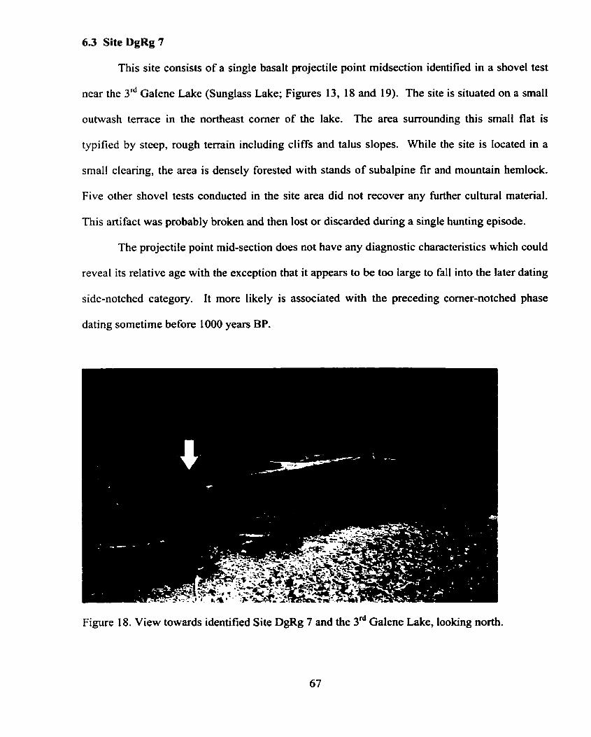
............................................................................................. subalpine zones 57 Figure 13 . Location of sites identified during the survey ................................................. 62 Figure 14 . General plan map of Site DgRg 5 .................................................................... 63 Figure 15 . View of DgRg 5 ............................................................................................ 64 Figure 16 . View of Upper Galene Lake and identified Historic Site DgRg 6 .................. 65 Figure 17 . General plan rnap of identified Historic Site DgRg 6 at Upper Galene Lake . 66 Figure 18 . View towards identified Site DgRg 7 and the 3d Galene Lake ...................... 67 Figure 19 . General plan map of identified Site DgRg 7 at the 3d Galene Lake ............... 68 Figure 20 . General plan map of identified Site DgRg 8 .................................................. -70 Figure 2 1 . Location of Site DgRg 9 ................................................................................. -73 Figure 22 . Trench feature at Site DgRg 9 ......................................................................... 73 Figure 23 . General plan map of Site DgRg 9 .................................................................... 74 Fi-vre 24 . Site DgRg 10 with Wright Peak in the background ........................................ 76 Figure 25 . Outcrop quany of Hozomeen Chert (DgRg 10) .............................................. 76 Figure 26 . General plan map of Site DgRg 10 .................................................................. 77 Figure 27 . View of Site DgRg 1 1 .................................................................................... -78 Figure 28 . Lithic tools and debitage recovered from Site DgRg 1 1 ................................. 79 Figure 29 . Historic tent platfoms at Site DgRg 1 1 .......................................................... 79 Figure 30 . General plan map of Site DgRg 1 1 .................................................................. 80
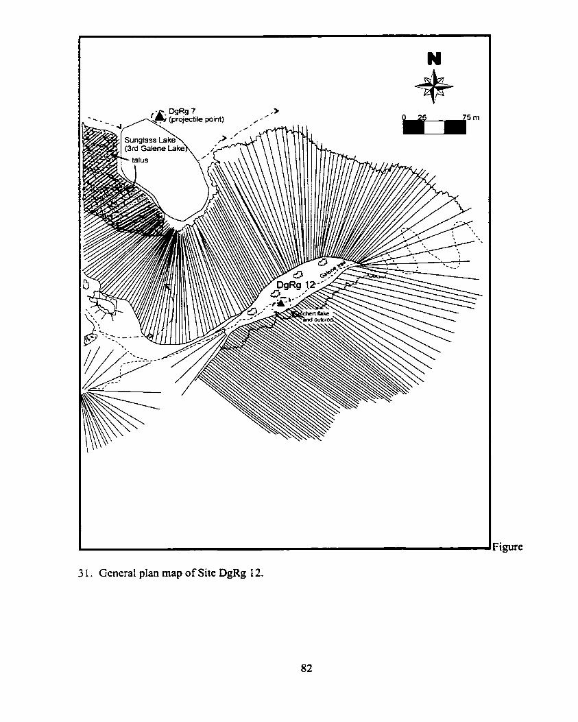
.................................................................. Figure 3 1 . General plan map of Site DgRg 12 82
vii
CHAPTER 1:
Introduction
This thesis explores the precontactl use of subalpine and alpine environments in the
Skagit Range of the North Cascade Mountains. In particular, it involves an intensive physical
survey of the area surrounding the Galene lakes within Skagit Valley Park, B.C. conducted in
1997 and 1998 (Figure 1). The primary goal of this study is to illustrate that mountainous areas
of southwestern British Columbia were important locations of traditional use by aboriginal
groups. The final goal is to attempt to formulate a mode1 of this land-use.
The initiative for conducting this project was a concern for the lack of previous intensive
research within mountainous areas, particuiarly in near-coastal regions where studies have
concentrated almost entirely upon the lowland maritime economic strategies of its precontact
inhabitants. A discussion of this disparity of research is presented as Chapter 2.
Mountainous areas hold a vibrant array of resources usually within a short horizontal
distance frorn areas traditionally studied. While the rigors of using such environments may seen
formidable to people today, mountains have lured people for millemia, including those cultures
which were considered to have had ample resources in easily accessible lowland areas. Bearing
this in mind it is important to remember that the vertical, severe landscape surrounding the
mainland valleys and coastal lowlands of British Columbia and Northem Washington which we
consider wilderness today, was not to the precontact people of this region (Mierendorf 1986:6).
Mountains held unique resources as well as important travel routes shared by different cultures.
The groups which used these areas, the fonns of use, and the possible archaeological residue
from such use is discussed in Chapter 3.
Figure 1. Study area location.
A discussion of the physical environment is provided as Chapter 4. This chapter outlines
those geological events which contributed to the unique nature of the study area as it appears
today, as well as how it must have looked in the past. Of importance in this chapter is the ever
shifting position of the treeline and how this would have affected the manner in which people
used the land.
Archaeological survey in mountainous environments brings with it its own challenges.
Methods require the flexibility to endure an environment capable of presenting severe changes
over brief distances and petiods of time. Chapter 5 looks at some of these challenges, provides a
sumrnary of the methodology ernployed, and finally makes suggestions for future work in similar
environments.
Chapter 6 presents the results of the survey. An attempt is made to match the type of
sites identified with the uses discussed in Chapter 3. The distribution of these sites forms the
basis of Chapter 7 in which a model for subalpine and alpine land use is offered. This model
focuses on the use of treeline transitional areas along major ridgelines with only a secondary
importance on proximity to water. Emphasis is given to the fact that treeline has changed
considerably over time, situating sites which were once in treeline transitional areas firmly in
what is r,ow subalpine. Two major tirne periods are believed to be represented in the study area:
the post-equestrian and early historic time period when the horse would have been available to
transport large amounts of trade goods (particularly dried huckleberries) from difficult to access
mountain areas represented by berry trenches; and a much earlier time period represented by
lithic anifacts.
Chapter 2:
Archaeological Studies in Mountainous Areas
This chapter reviews the amount and degree of past upland archaeological work in British
Columbia and secondly in the Chilliwack Forest District adjacent to which the shidy area and
Skagit Valley Provincial Park fall. It examines why upiand archaeology has not been conducted
in the past and why it is only now starting to become a matter of concem. Lastly, it provides a
brief prehistory of the North Cascades and surrounding area. As several terms are used to
describe the different zones within 'upland' areas it is necessary to define them as they will be
used in this thesis (see Figure 2). These terms can be used in mountainous areas throughout
North Amerka, however, at what elevation they occur and the size of each zone will differ fiom
region to region. 'Upland' refers to al1 areas above the lower subalpine. 'Subialpine' refers to
the area which is continually treed immediately below the 'Sublapine Parkland' The Subalpine
Parkland consists of small patches of trees intenpersed with meadows. The 'krurnholz' refers to
the stunted tree zone just below the 'Alpine' which contains no trees at al1 with the exception of
the very odd twisted specimen.
Figure 2. Mountain schematic showing the location of zones mentioned in the text.
The archaeology of mountainous areas in British Columbia should be considered to be in
its infancy, possibly in ufero. The reasons for this are vaned including a general preconception
by many archaeologists that steep rugged areas could not have been used in pre-contact times,
and if they were, this would have been so fleeting as to leave only small, imperceptible traces.
These areas were generally not considered to hold the resources requisite for human subsistence
or of a high enough value to have enticed precontact people in any type of consistent fashion.
This is a highly westernized, agriculturally-based view as is reflected in current settlement
pattern choices in major valley bottoms and along the Coast. Mountainous areas today are only
used for bnef recreational episodes or for the extraction of industrially important raw materials.
People generally do not live in them.
A second factor that has affected the amount of past archaeological research in
mountainous regions is simply the difficult logistics of doing such work. There are few
archaeologists who are willing to spend the time to gain access to the mountain world especially
with the preconception of finding little or no data upon arriving. The access problem has been
mitigated to some extent as modem roads cut deeper into upland areas and helicopters can
readily dispatch people and gear with pin point accuracy; however, once the vehicle has been
left, the survey can once again become onerous. Further, there is some concern over whether or
not this ready access is an appropriate manner in which to conduct archaeological research in
such areas (B. Mierendorf, pers. comm. 1999). Without total immersion in the environment and
appreciation for the methods of access used by the precontact people we study, it is exceedingly
difficult to understand just where sites might be located.
Often a great deal of data can be gleaned from archaeology which has been conducted
under contract such as archaeological impact assessments and mitigative excavations. This type
of work, however, is almost entirely conducted in response to development activities which
generally do not occur in upland areas and if they do, at least up until the recent pas?, d o not
5
usualiy require that such inventory and assessrnent be undertaken. Such studies, while usefiil,
are not ideal as they usually focus on small areas such as a proposed cut-block or road section. It
is difficult to understand the use of the mountain or any environment from such small parcels of
information. It is also difficult for the contracting archaeologist to appreciate the land-use of
such environments if they are suddenly injected into an artificially constrained work area for a
relatively short time. This piecemeal research contnbutes little to the overall picture of
precontact mountain use.
2.1 Upland Archaeology in British Columbia
The mountainous areas of British Columbia have received little archaeological attention,
the majority of which, up until very recently, has been associated with contract archaeology.
Drawing from a study conducted in 1997 showing the distribution of past archaeological work
(Franck ef al. 1997a, 1997b) it is possible to determine where intensive archaeological survey
work has been conducted throughout the province. Figure 3 below shows the percentage of past
intensive archaeological research which has occurred in British Columbia up until 1997 in those
biogeoclimatic zones (as defined in Meidinger and Pojar 199 1) which occur at relatively high
elevations (i.e., ESSF, MH, and AT*) as opposed to those biogeoclimatic zones which occur in
Iow to middle elevations (i.e., BG, BWBS, CWH, ICH, IDF, MS, PP, SBPS, SBS*) The overall
distribution of these areas in British Columbia is s h o w in Figure 4.
From Figures 3 and 4 we can see that survey within mountainous areas of the Province
has been greatly underrepresented. While 34% of the Province falls within rnountainous
biogeoclimatic zones (Figure 4) only 8% of past archaeological survey has been located in such
areas, whcreas 92% of past survey (Figure 3) has occurred in rniddte and lowland biogeoclimatic
zones which encompass only 66% of the Province. Ohviously survey allocation has been biased
in lowland areas both by past research designs and development-related archaeology.
Survey Distribution in BC. (1997)
Figure 3. Survey distribution in British Columbia according to biogcoclimalic zones
( d m from Franck ex al. 1997% 199%)-
l 1 Land Distribution in B.C. 1
I
*AT= Alpine Tundra; BG= Bunchgrass; BWBS= Boreal White and BIack Sptuce; CWH= Coastal Western Hcmtock; ESSF = Engelmann Spmce-Subalpinc Fir, ICH = Interior Ccdar Hemlock; 1DF = Intcrior Douglas Fir; MH= Mounuin Hcmlock; MS = Montanc Spnicc; PP = Ponderosa Pine; SBPS = Sub-bord-Pinc Spruce; SBS = Sub-boreal Spruce (Mcideingcr and Pojar 1991).
Figure 4. h d distribution in British Columbia according to biogeoclimatic zones
(data fmm Franck et al. 1997% 1997b).
2.1.1 The Chilliwack Forest District
Looking specifically at the Chilliwack Forest District, the district in which the study area
falls, the numbers are even more biased regarding past archaeological research in lowland versus
upland areas. Figures 5 and 6 show that only 7% of past research falls within the higher
elevation zones3 which comprise 36% of the district (Franck et al. 1997). This scsrcity of work
in upland zones has changed only slightly in the last couple of years since the data used in these
figures was collected. In addition to the work presented in this study, recent archaeological work
in the ESSF, MH, and AT zones within this area include research projects by St6:IÔ Nation
7
(Schaepe 1998a) and Simon Fraser ~ n i v e r s i g as well as a few projects by archaeological
consultants. Even with these recent contributions the overall ratio between lowland versus
upland studies in the Chilliwack Forest District is still weighted heavily towards lowland work.
Survey distribuiton in the Chilliwack Forest Dis trid 93%
V '
Hgher Bevaüon Zones Low er ûevaüon Zones
Figure 5. Survey distribution in the Chilliwack Forest District according to biogeoclimatic zones (data frorn F m c k er a/. 1 997a. 1 997b).
I I Land distribution in th. Chilliwack I Fomt District l
I 1
Higher Elevation Zonas Lomtr Uevation Zones 1 Figure 6. Land distribution in the Chilliwack Forest District according IO biogeoclirnatic zones (data frorn F m c k et al. 1997a. 1997b).
2.2 Previous Archaeological Studies
Table 1 shows the distribution of past upland archaeological investigations in the larger
region surrounding the study area both in British Columbia and Washington State. Using the
southem Interior Plateau and Mountains, Cascade and Coast Mountains of British Columbia, and
the Olympic, South and North Cascade Mountains of Washington State as the areas with the
most relevance to the study area, the limited amount of previous archaeological work becomes
evident. It is important to note that many of these studies fa11 only within the subalpine zone.
Only a very few fa11 within the subalpine parkland, krurnmholz, or mie alpine.
Table 1. Previous upland work in southem British Columbia and Washington State (does not include the Roc kiesKoo tenay area or Vancouver Island).
Blukus Onat 1988 Fulkerson 1988 Grabert 1975: Grabert and Chesmore 1979: Grabert and Pint 1978: Hartman 1980 Hedlund 1986 Mierendorf 1 986. l987a. 1 987b. 1993,1997, Mierendorf and Harry 1993: 1998:Mierendorf and Skinner 1997: Mierendotf and iho ipson i 986: Mierendorf et ai. 1998 . Miss and Nelson 1995 Rice. H.S. n.d.a.. n.d.b. Rousseau 1988 Schaepe 1998
Vivian 1989a, 1989b, 1992 t
Bergland 1988,1986 4
Burtchard 1998 ' ~ a c k 1989. 1992a. 1992b. 1993.1996. Mack and hlcclure 1998: McClure 1989. 1992
I ~ i c e . D.G. 1964.1965 1 Zweifel and Reid 1991 Berqland 1984 Arcas 1 999 Eldridge. Morely 19%;McÏren et a1.1997
Franck 1997 Joseph. L. and E. Bikadi. (Creekside Resaurces) 1998
1 Merchant 1998 1 Reimer 1998,1999
Rousseau et al. 1993 Spafford et al. 1994: Alexander 1994 Bailey 1995: lqnace et. al 1995 Merchant and Rousseau 1995 Pokotvlo 1976a. 1976b. 1977.1978.1979.1981.1985: Pokotvlo
land ~e i rne 1978 1
Mt. Baker (North Cascades) t4eaiow River (North Cascades) North Cascades National Park. Washington State North Cascades North Cascades North Cascades National Park. Washington State
Nom Cascades North Cascades Nationai Park*
ChihiRhva& River (North Cascades; Skagit Range)
Similkameen Valley (North Cascades) 1 IMOU~~ Rainier National Park (Souh Casudes) 1
~ [L i l l ooe t (Coast Mountains) 1 e!~hulasJ Ranqe (Coast Mountains a Callahan Lake (Coast Mountains !car Whis(ler) BILost Valley (Cayoosh Range: Lillooet) 1 MiGarabaldi (Squamish) 1
In the immediate study area surrounding Ross Lake and the upper Skagit River the vast
majority of past archaeological work has been conducted to the south of the international border
associated with draw-downs of the Ross Lake Reservoir (Le., between 454 and 488 m ad.) and
the designation of North Cascades National Park (Figure 7). Unfortunately there are no studies
which pre-date the inundation of the valley (Mierendorf et al. 1998:23).
2.2.1 Archaeologv in North Cascades Park, WA
The earliest surveys in the North Cascades Park (NCP) area of Washington State were
conducted by Rice (n.d.a., n.d.b.). However, no sites were located during these efforts and the
notes regarding rnethodology and actual areas covered are too sketchy to determine the efficacy
or completeness of these surveys. Rice does state in his report that sites were probably not found
because of the lack of anadromous fish and "because there were not many places where
archaeological sites would logically be expected" (in Mierendorf et al. 1998:3 1). Grabert and
Pint (1978) recorded the first two archaeological sites along Ross Lake in 1977, one of which
(45 WH79) consisted of a thick lithic scatter thought to hold artifacts of some antiquity.
However, the suspected antiquity of this site was later overturned by Mierendorf and Thompson
(1986) who believe that selective artifact collection at the site may have incomectly lead to this
presumption, and instead recognized it as a later dating site. Since Grabert, several studies have
been undertaken in NCP focusing primarily around the rnargins of Ross Lake as well as areas
which became exposed during various draw-down occurrences (Mierendorf 1986, 1987b, 1993,
Mierendorf and Hamy 1993; 1998; Mierendorf and Thompson 1986; Mierendorf et al. 1998).
Although a relatively small arnount of high elevation wcrk has been conducted south of the
border it greatly exceeds that which has been done in nearby areas to the north (e.g., Mierendorf
1987a, Mierendorf 1997; Mierendorf and Skinner 1997).
Figure 7. Location of thesis study area in relation to major parks.
To date, 150 archaeological sites have been recorded within North Cascades Park, 144 of
which are precontact in age and 6 of which are historic (Mierendorf et al. 1998:60). Also noted
are 66 isolated finds6. The vast majority of the these sites (128) are located in draw-down areas
below 488 rn asl. (lowland areas), whereas only 22 sites have been identified above this
elevation. This difference is due mainly to a higher survey area concentration in lower areas and
the excellent ground surface visibility present in the draw down-zone (i-e., it is denuded of
vegetation). One site of particular interest is the Desolation Chert Quarry (45 WH224) located
both above and below the high level of Ross Lake ( 4 8 8 m asl) a little over 2.0 km north of
Lightning Creek on the east side of Ross Lake. This site represents a major source area for
workable Hozomeen Chert, the dominant Iocal lithic material used by precontact people in the
area. Dates from limited test excavation at the site suggest that this resource has been used for at
least the last 7,600 years (Mierendorf 1993). Two other chert quarry sites have also been
recorded in the Park (Mierendorf et al. 1998).
Mierendorf (1 997) did survey briefly through the thesis survey area searching for glassy
volcanic rock sources associated with Mt. Rahm volcanics. He identified two of the sites (DgRg
9 and 1 1) which were later re-examined as part of this study. As Mierendorf's survey was
largely exploratory, and because of the fact that he did not hold the necessary permit to test on
the Canadian side of the border, he did not investigate these sites to any great extent. Just south
of the border during the sarne survey Mierendorfalso identified a small historic site (45WH5 19)
as well as a pit built at the bottom of a talus slope (Isolated Find 106) which he interprets as
possibly representing a temporary storage cache.
2.2.2 Archaeologv in Skaait Valley Park, B.C.
As mentioned earlier, little archaeological work has occurred on the Canadian side of the
North Cascades in what is now h o w n as Skagit Valley Provincial Park (SVPP). The first
survey conducted in the area was associated with the proposed High Ross Dam (Eisner 197 1)
which would have flooded areas well into Canada but was never realized. This survey, although
it did atternpt to look at a fairly large area (fiom the border north for about 20 km along the
Skagit River), failed to locate any archaeological resources. Unfortunately such work in forested
environments was fairly new and did not include shovel testing making the study somewhat less
than intensive.
The first recorded site on the Canadian side of the study area (DgRg 1) was identified by
W. "Curly" Chittenden, one of the first homesteaders in the area (Figure 8). In 1972 whiie
bulldozing, Chittenden uncovered a carved bird-effigy Stone bow17 as well as a small scatter of
lithic artifacts about 4 km northwest of the Ross Lake Campground. Chittenden did state in an
interview (Chittenden 1994 in Bush 1997: 17) that he had also collected artifacts during the 1930s
and 40s in what is now known as "Chittenden Meadow" located at the north end of Ross Lake
Reservoir.
Rousseau (1988) recorded the first two sites within Ross Lake campground (DgRg 2 and
3) in 1988 as part of an impact assessrnent for the expansion of the campground (Figure 8). Both
sites are lithic scatters, the larger and denser of which (DgRg 2) extends southward into the
United States joining with a site originally recorded by Grabert and Pint (1978; Site 45-WH-79).
Surface collection and a small test excavation at Sites DgRg 2 and 3 place them somewhere
between 6000 and 2400 BP.
Figure 8. Sites recorded in Skagit Valley Provincial Park (150,000; NTS 92W3).
Bush (1997) recorded the fourth site within the same borden unit (DgRg 4) as part of her
Master's research at Western Washington University (Figure 8). This site, which is located
approximately I O km north of the border and about 1 km east of the Skagit River, was revisited
by the Western Washington University field school in 1997 for further investigation (Bush
1 998). Excavation identi fied a large hearth feature of unknown function, a least 13 di fferent
types of lithic matenal, and two diagnostic projectile points. One sternrned point may date fairly
early; however, no absolute dates have been run at this tirne. The site appears to be located along
a definite trail route probably chosen to avoid the difficult washed-out areas irnmediateiy
adjacent to the Skagit. The latest archaeological work to be conducted in the Park took place in
Chittenden Meadow as well as the northern drawdown area of Ross Lake (Figures 7 and 8). This
was a joint effort between Stolô Nation, Simon Fraser University and North Cascades Park
Complex (Lepofsky, pers. cornm. 1999). Dunng this study a possible beny drying trench was
identified (DgRg 18; Figure 8) in Chittenden Meadow as well as four small lithic scatter sites in
the drawdown area (DgRg 14-1 7; Figure 8).
2.3 Regional Archaeological Chronology
There is no established precontact sequence for the North Cascades area at this time.
Attempts to develop such a sequence involve borrowing time-lines from adjacent lowland
constmcts and attempting to tie thern together with the small amount of chronornetric
information which has been garnered from mountain settings (e.g., Mierendorf 1986; Mierendorf
et al. 1998). This is probably a sound approach (basically the only approach at this time) as
peripheral lowland cultural developments no doubt had considerable influence on the extent and
intensity of the use of mountain areas. It should be noted, however, that not al1 the groups which
are reported to have used the range ethnographically are associated with coastal economies (e-g.,
the Niaka'pamu; see Chapter 3.0). There is no evidence that any groups lived in higher portions
of the North Cascades year-round which makes extrapolations from surrounding established
chronologies somewhat appropriate. Slightly more work has been undertaken constnicting such
a sequence for the South Cascades (e-g., Lewarch and Benson 199 1; Burtchard 1998); however,
whether or not this is relevant to the study area concerned here is not clear. These latter studies
do, however, provide good baseline information for cultural changes on a more regional scale.
The earliest known use of the North Cascades and its peripheries extends as far back as
late Pleistocene times (I0,OOO-12,000 years ago) as evidenced by the presence of Clovis spear
points at the East Wenatchee (Richey Clovis Cache) Site in Washington State (Gramly 1993;
Mehringer 1988; Mehringer and Foit 1990; Meltzer and Dunnell 1987) and possibly by recent
finds of Scotsbluff-like spear points during drawdown surveys at Stave Lake (Figure 7) in British
Columbia (Eldridge and McLaren 1998; Maxwell Christensen and Owens 1998; McLaren et al.
1997a, 1997b; Mclaren 1998; McLaren and Maxwell 1998; McLaren, D, J. Stafford and
TDandurand 1 998; Millennia Resarch Ltd. and Kwantlen First Nation 1998; Ryder 1998;
Stafford and McLaren 1998, Vincent 1998). Absolute dates have not been attained for any of the
'apparently early' point styles recovered in the region . In the Stave Lake case this is due to the
disturbed context in which the artifacts were found, while a single mid-Holocene date from the
Wenatchee Site does not correlate with other dated Clovis Sites. A single Clovis projectile point
found near Lake Cle Elum (Hollenbeck and Carter 1986) in Washington State represents the only
such artifact which has been found directly in the Cascade Range.
The very recent discovery of a stemmed projectile point in the lower Fraser Canyon (D.
Schaepe, pers. comm. 1999) resembles others which have been dated in early contexts in nearby
plateau areas of Washington and Idaho (e-g., Rice 1972). This artifact does not, however, exhibit
the heavy edge grinding which is comrnonly found on early dating artifacts of the same type.
Some researchers, particularly Bryan (1 980, 1988) suggest that the stemrned point tradition may
16
in fact pre-date that of the more well-known Clovis culture, although this remains a bone of
contention with many. A single stemrned projectile point was recovered in an excavated context
within Skagit Valley Park near the study area (DgRg 4; Figure 8) by Bush (1998); however,
dateable material was not found associated with this artifact.
Regardless of the fact that these artifacts described above (Clovis, Scotsbluff, and
Stemmed Projectile Points) are not associated with absolute dates, their presence in and around
the North Cascades does suggest that late Pleistocene (presumably big game hunters) were in the
Northwest at this tirne, and could well have utilized its mountainouc regions.
Other sites considered to perhaps faIl within this early period within the region include
the South Yale Site fiom which a previously unknown lithic tradition termed the "Pasika
Complex" was identified. This complex consisted of large waterwom chopping tools which
were believed to predate artifacts found at the nearby Milliken Site (DjRi 3; Irvine 1973; Kidd
1968; Mitchell 1965; von Krogh 1975). This inference was based on the apparent crudeness of
the tools without any absolute dates to substantiate such a claim. Artifacts similar to that found
at the South Yale Site were also identified near Hope, B.C. (Site DiRi 1; Franck et ai. 1994).
Haley (1987, 1996) later established that the crude unifacial cobble tools characteristic of the
postulated Pasika Complex are more than likely associated with later period developments. Such
artifacts have been found in fairly recently dated sites and appear to represent a common tool
type used over a long period of time.
There is considerably more evidence for use of the region during the time period between
9,000 and 4,000 years ago. The earliest date fiom this time remains the "Old Cordilieran
Tradition" component excavated at the Milliken Site in the southem portion of the Fraser
Canyon (Borden 1960, 1975; Mitchell and Pokotylo 1996). This tradition is typified by large
leaf-shaped knife and spear points in association with otherwise simple Stone tools. Sites to the
south and east of the North Cascades which fa11 within this time period include those excavated
17
along the Columbia River between the Okanagan and Wenatchee Rivers (Mierendorf and
Bobalik 1983; Galm and Masten 1985; Chatters 1986). This early Holocene period is
represented in the study area most locally by the Desolation Chert Quarry which produced a
basal date of around 7,600 BP with the heaviest use occumng between 3,500 and 5,000 BP
(Mierendorf 1093). Mierendorf (1991) suggests that the North Cascades appear to have been
used more intensively during the middle Holocene time period than any other (Mierendorf 1998).
Other North Cascades area sites which fa11 within the early to mid-Holocene time period in
Washington State include Chester Morse Lake which produced a date of 8,540 BP (Samuels
1993); and dates inferred fiom artifact types recovered fiom the lower Similkameen River Valley
(Salo 1987).
Sites fiom the mid-Holocene period are believed to reflect the use of a wider vanety of
plants and animals than had occurred in earlier times; however, did not generally involve food
storage or the establishment of semi-permanent villages (Schalk and Cleveland 1983; Arnes and
Maschner 1999). Anomalous mid-Holocene village sites or sites which contain residential
structures near the study area, include the Esilao Village Site (DjRi 5; Borden 1975; Figure 9)
located in the lower Fraser Canyon, and the Maurer Site (DhRk 8; Leclair 1973, 1976; Schaepe
1998b; Figure 9) located in the upper Fraser Valley. The dates for these houses do fa11 within the
latter portion of the mid-Holocene (ca. 4000 BP) exhibiting the next general trend toward
sedentism. From 4000 years ago up to the tirne of susiained contact with Europeans (around 200
years ago), a dramatic shift in the economies of Nonhwest People began to occur. This period
saw the establishment of large permanent villages, an emphasis on food storage, and a general
decline in wide-ranging food procurement except by small task-onented groups (Schalk and
Cleveland 1983; Kuijt 1989). Village sites associated with this time period include the Flood
(DiRi 38) and Pipeline (DiRj 14) pithouse sites excavated by von Krogh (1980) near Hope, B.C.
DjFü 3 DjR 5 DjRi 7 DiRi 1 DiRi 39 DiRj 1 DiRj 14 DhRk 2 DhRk 8 DhRl16
K ~ Y Miliken Esilao Village South Yale HoOe Sihrerhope Creek Kaîz Pipeline McCallum Maurer SclMitz
Figure 9. Location of selected archaeological sites in the upper Fraser Valley and lower Fraser Canyon referred to in the text (adapted fiom Franck et al. l994:6).
and the Scowlitz @hm 16) mortuary mound and village site located at the confluence of the
Harrison and Fraser Rivers which is still under investigation (Lepofsky et al. 1999,2000; Figure
9). Dates obtained fiom these sites range fiom Ca. 2800 to 300 BP (von Krogh 1976, 1980;
Lepofsky et al. 1999). Other pithouse vi!Iage sites located near the flanks of the North Cascades
representative of the late Holocene time period include those near the Okanagan (Grabert 1968),
Methow (Swanson 1959), and Columbia (Nelson 1973) River valleys. Sites which actually fa11
within the mountainous areas of the North Cascades fiom this tirne period are thought to
represent the srnall, task oriented groups which radiated out fiom these larger villages in search
of game and plants that were not available in lower climes (Mierendorf et a/. 1998~36-7). These
sites are generally typified by thin, usually unstratified, lithic scatters, depressions from roasting
and cache pits, and possibly depressions associated with the drying of huckleberries.
The protohistoric and early historic period saw enormous changes in the way aboriginal
peoples used the land. This was influenced particularly by the decimation of the aboriginal
population from European diseases such as smallpox (Carlson 1997; Harris 1994) as well as
technological influxes including the horse and metal tools. Such changes greatly affected the
way in which aboriginal people used the land perhaps initiating a greater dependence on certain
resources than had occurred previously. This would have greatly affected the way in which this
use was portrayed archaeologicaIly over the landscape and may be responsible for such
archaeological sites as the berry trenches which are presented in this study.
Chapter 3:
ETHNOGRAPHY AND HISTORY OF THE STUDY M A
This chapter is a compilation of the ethnographic and historic land-use information of the
study area. Most weight is given to the aboriginal use of the land as such use is the centrai focus
of this thesis. A basic historical summary is also given as some of the events within this history
have affected the way in which abonginal use of mountainous areas changed over time, as well
as directly contributed to the archaeological record itself.
3.1 Ethnography
The ethnographic record of the study area has been extracted primarily from studies
conducted in the peripheries of the North Cascades. While these ethnographies do contain some
specific information regarding the use of upland and mountain environments, they are heavily
weighted towards lowland subsistence activities and cultural organization. Nevertheless, a
suitable amount of information can be derived from these early works to begin to understand
land-use patterns within mountainous areas, and suggest what residues this use might have lefi
behind. This chapter begins with a brief description of the main cultural groups which are
believed to have used the study area ancilor areas near to it. Secondly, it discusses how and when
this use occurred begiming with hunting strategies, followed by plant extraction, and finally
other uses. Suggestions regarding how each particular cultural activity might show up on the
iandscape today are also presented.
There appears to be no one First Nations group which can lay sole claim to use of the
mountainous areas within and surrounding the study area. There is also no evidence that any
particular group occupied the region on a year-round basis, although extended forays into it are
suggested for some. The main First Nations groups concemed here include (fiom north to south)
the Lower Nlaka'pamux (or Thompson); the Tait and ChilIiwack Tribes of the Upper Sto:lô ; the
Nooksack; and the Upper Skagit. Other possible usen of this country include the now-extinct
Athapaskan-speaking Nicola people, as well as North Okanagan people from the Similkameen
area. Information regarding these last two groups, however, is brief and is not discussed further
in this thesis.
Territorial maps are provided within ethnographies for all of the groups mentioned above.
These include those provided by Teit (1900: 166) and Laforet and York (1998:4) for the
Nlaka'pamux; by Duff (l952:2O) for the Upper Sto:lô Chilliwack and Tait û-ibes; for the
Nooksack by Duff (1952:2O and Smith 1950:340), and for the Upper Skagit by Collins
(1 974: 17). Considerably more information regarding traditional temtones of these groups is
provided as part of the text within these volumes, among others. Much of this work has been
surnmarized by Smith (1988) which represents the only major attempt so far to synthesize the
previous ethnographic work for the mountainous areas of the North Cascades. Figure 10 below
provides territorial boundanes for First Nations discussed in this thesis as outlined in the
ethnographies discussed above.
3.1.1 The Lower Nlaka'~amux
The Lower Nlaka'pamux represent the only Interior Salishan-speaking group which used
the study area to any considerable extent (Figure 6). The language spoken by the Nlaka'pamux,
known as "Nlak'pamuxcin", is considered distinct though related to that of Shuswap
(Secwepemc) and to a lesser extent of Lillooet (Stl'atl'imx). Al1 three languages comprise the
Northem Group within the Interior Salishan Division (Thompson 1979:692-695). While the
main body of traditional Lower Nlaka'pamux temtory is located in the Fraser Canyon area with
Spuzzum (Sps'zêm) representing the most southerly winter village, the hunting and gathering
area of the Nlaka'pamux is believed to have extended far below the international border (Hill-
Figure 10. Traditional territories of First Nations mentioned in the text, as well as that of surrounding groups. (Base map adapted from Draffen et al. 1993:3 1 using informaticri provided in Collins 1974: 17; Duff i952:20; Laforet and York 1998:4; Smith 1950340; Smith 1988:7, 17)
Tout 1900; Laforet and York 1998; Smith 1988; Teit 1900). According to Teit (1 900: 166) the
Lower Nlaka'parnux hunted in and lay claim to areas surrounding the Upper Skagit and what is
now Ross Lake, as well as the mountainous regions surrounding Chilliwack Lake and the upper
Chilliwack River. To the south this use was believed to have extended to the "headwaters of the
Nooksack and Skagit Rivers" (Teit 1900: 168). In later times when the Athapaskan-speaking
Nicola died out in the protohistoric and early historic period, the Nlaka'pamux expanded into
their temtory to the east as well as areas also used by the North Okanagan in the Similkameen
Valley (Smith 1988)-
The Nlaka'pamux are believed to have used the study area primarily during the winter,
arriving on snowshoes afier the Fraser Canyon fishing season ended and interests tumed more
towards that of hunting (Collins 1974: 14-15,66). Certain groups of Nlaka'pamux are believed to
have stayed through the winter in order to hunt, fish, as well as gather plant crops during the
spring and surnmer (Collins 1974: 14-1 5,66). Teit (1 9OO:239) notes that hunting parties visiting
this southernmost portion of their traditional temtory would sometimes be gone upwards of
seven months, returning "only when the snow began to melt in the mountains". Smith
( 1988: 19 1, 230) suggests that if such winter use did occur within the mountainous areas of the
upper Skagit and Ross Lake area, substantial campsites/village sites must exist in or near the
study area since the closest permanent winter village of the Nlaka'pamux was at Spuzzum
(Spô'zêm), 77 km north of the international border.
Trails used by the Nlaka'pamux to access the study area are not well known, except for
those which followed either side of the upper Fraser Canyon, which Fraser (1960:96) described
as being somewhat p i l o u s routes "where no human being should venture". In order to enter the
study area entirely through their own temtory would have been particularly arduous. Instead it
is considered more likely that they moved through the territories of the Halq'eméylem speaking
Upper Sto:lô groups of the Lower Fraser Canyon and Hope area, then by the Silverhope-
24
Klesilkwa (Mierendorf et al. 1998: 1 1; Smith 1988: 19 1) route, or by way of the Similkameen-
Lightning Creek route (Smith 1988: 191). The tricky canyon trails could have been avoided
through the use of a known route to the West past Harrison Lake, Lillooet River, and Lillooet
Lake, over to Anderson and Seton Lakes, finally descending the Inkmutch River to the Fraser
below the Canyon (Mayne 1862:67,93-54, 132-138). A connection with the Skagit Valley, the
North Cascades (including Mount Baker), and trails leading through the rnountains to reach this
area are noted in Laforet and York (1 998:4,5,66).
While in the Skagit River and Ross Lake area, Nlaka'pamw would sometimes encowiter
Upper Skagit groups whose northern traditional use boundary is believed to have been located
near the study area (see 3.1.4). Such encounters often resulted in hostilities as both groups
claimed use of the area and saw the other as a distinctly foreign group both in appearance and
language (Collins 1974: 15, 1 15, 1 1 8- 1 19). Other groups believed to have encountered the
Nlaka'pamux in the area (Upper St9:lô and Nooskack) were thought to have been on more
fi-iendly terms; however, the Chilliwack are also reported to have fought at times with the
Nlaka'pamux during mountain meetings (Smith 1988: 142).
3.1 -2 The Upper Sto:lô
While six separate "tribelets" are considered to comprise the Upper Sto:lô Culhre Graup
(Duff 1952: 1 I - 12; Elmendorf and Suttles 1960: 1-2, 17) only the Tait and the Chilliwack are
believed to have used the Skagit Valley and the mountainous areas above which the study area
falls (Smith 1988; Figure 10). Both groups were speakers of the Halq'eméylem language of the
Coast Salish Language Group; however, the Chilliwack were believed by sorne to have spoken a
language similar to the now-extinct Nooksack language as late as 1700 (Boas l894:4%; Duff
1952: 1 1, 12, 39,43; Hill-Tout 1903:355, 357).
The Tait occupied the lower part of the Fraser Canyon as far north as Five Mile Creek
just south of the Nlaka'pamux village of S p m m (Spo'zêm), and as far south as Seabird Island
and Popkum (Duff 1952: 19). The Chilliwack originally lived in the area of the Chilliwack River
Canyon and above and are believed to have only recently moved down along the Fraser during
the 1830s (Boas 1894:455-456; Duff 1952:43). It is suggested that this move occurred at this
time because of the protection fiom downstream raiders offered by the presence of Fort Langley,
as well as the change in course of the lower Chilliwack River (Boas 1894:455-456; Duff
1952:43). This lower portion of the river which originally emptied into Sumas ~ a k e ' before
entering the Fraser, switched to a northern course and its present Vedder Crossing locality
sometime in the early histonc period (Smith 1988). This change resulted in the developing
Chilliwack prairie which was at one time a spongy, wet, and generally undesirable area for
habitation (Smith 1988:79).
Unlike the Nlaka'pamux, Upper Sto:lô groups were believed to have used the study area
pnmanly during the summer and fa11 (Smith 1988). The main area of use for the Chilliwack is
beIieved to have been that around and above Chiiliwack Lake; however, there is some indication
that they occasionally ventured east into the immediate study area (Smith 1988). Duff (1 952:î 1)
notes that the Tait sent hunting (and gathering?) parties into the mountainous areas several days
east (and presumably south as well) of the Fraser during which time they sometimes met Upper
Skagit people. This suggests that the Tait likely did utilize the study area. The meetings
between the Tait and the Upper Skagit were believed to be usually fnendly; however, the
Chilliwack and Upper Skagit supposedly had rare hostilities (Collins 1974: 1 18- 1 19).
Major trail systems leading fiom central Upper Sto:lô Temtory into the study area are not
weli known; however, several indications that the Upper St6:lô had contact with plateau
(Okangan-Colville) groups to the south and east of their cc're areas suggests that these trails
likely passed through or near to the Ross Lake/Skagit River area (Ross 1956:37). These routes
26
likely included trails along the Methow and Similkameen River systems (Brown 1914; Smith
1946:309, 3 16, 320). It has k e n suggested that the similarity between middle Fraser and
Columbia Plateau and Coast petroglyphs suggests that such a co~ec t ion did exist; likely by way
of a trail through the Cascades (Smith 1946). In the more immediate study area trails are
expected to exist between the Hope area and the Skagit via Silverhope Creek and the Klesiikwa
River as this represents the easiest physical route from the north (Mierendorf et al. 1998: 1 1).
Several sites identifid in 1999 along Silverhope Creek (Franck and Schaepe 1999) may be
evidence of this use. For the ChiIliwack it is likely that trails extended eastward from their core
tefitory in the Chilliwack Lake area towards the study area over some of the high rnountain
passes. Wilson (1970:62-63) notes that the Chilliwack did appear to have considerable
knowledge of the resources of the study area.
3.1 -3 The Nooksack
Little is known of the Nooksack people who occupied the area to the south of and
overlapping with the Chilliwack (Figure 10). Smith (1950) notes that the culture is generally
considered to be extinct but suggests that the Nooksack had a close relationship with the
Chilliwack people perhaps due largely to the fact that the old course of the Nooksack River at
one tirne ran north into the SardisKhilliwack area. An historic trade co~ec t ion fiom Fort Yale
through Chilliwack, Nooksack, and finally Lurnmi was the most-used route between the Fraser
and Puget Soucd (Smith 1950:33 1). This connection is believed to have extended into
precontact times during which the Nooksack obtained grass [Indian hemp] for making fish nets
from the Nlaka'parnux and sturgeon gtue used to make sinew-backed bows from the St6:lô
(Smith lgSO:332).
Most important to this thesis is the fact that the Nooksack were more or less an inland
people with little direct contact with tnie coastal groups. Marian Smith (1950) postulated that
this inland and upland existence constituted a type of "Foothills" culture that developed on the
western flanks of the Cascades (Smith 1950: 336). However, little was offered by Smith to
distinguish this culture from surrounding groups (Smith 1988:98) which brought criticism to her
constnict (e-g., Suttles 1957). Regardless of Smith's success in succinctly defining the
"Foothills" culture, it is probably reasonably safe to say that the Noosack did use the
mountainous areas to the east of them. These areas would have held numerous valuable
resources which could be consumed a d o r would have figured prominently as trade items with
more coastal-based groups.
3.1 -4 The Upper Skagit
The Upper Skagit spoke a dialect o f Looshootseed (Puget Sound Salish), a language that
was considered quite different and unintelligible fiom that of Nooksack, Halq'eméylem, and
especially Nlak'pamuxcin (Suttles 1957: 163, 1985; Thompson l979:693).
The very northem portion of the traditional temtory of the Upper Skagit people was
located along both sides of the upper Skagit River and surrounding mountains placing them
directly within the surveyed area covered in this study (Figure 6). The main body of Upper
Skagit tenitory including the locations of their permanent villages, however, lay considerably
further south no higher than the community of Newhalem along the Skagit River in Washington
State (Smith 1988:ZO).
The Upper Skagit are believed to have had a strong trade network with plateau groups to
the east, indicating that they were accustomed to travel across the Cascades (Smith 1988:33).
Such travel, as with the Nlaka'parnux, was conducted primarily in the winter when the rough
terrain was smoothed by snow (Collins 1974:6; Smith l988:57). With the introduction of the
horse, the trade network expanded in size and range including such goods as "root cakes, dried
berries, buffalo robes, and many other heavy or bulky packs, which in former days it did not pay
to carry [across the mountains]" (Teit 1928: 12 1).
The Upper Skagit were believed to have used the Ross Lake and immediate study are2
primzrily dunng the summer months generally as a resource area, not as a place of long-term
residence. During these months they would enter the high country to hunt garne and gather
plants which were not available in the lower areas near their winter homes to the south (Smith
198855). The main route into this area was, most obviously, up the Skagit River probably by
both footpath as well as by canoe for some stretches (Smith 1988:32-33). The trail was
improved in 1852 extending up into British Columbia where it connected with the Niccolum trail
(Collins 1974:38). This trail, which was improved by Euro-Americans, likely followed the
original abonginal trail into the area. Many of the original trails had become overgrown and
impassable by the mid 1800's due to disuse by the Upper Skagit caused by decimation of the
population fiom European disease and a shifting economy based more on trading with European
fur traders than with traditional partners (Gibbs 1877: 180).
As mentioned previously for the Nlaka'pamwc (Chapter 3. I . l), the Upper Skagit and the
Nlaka'pamux were known to be hostile to one another when meeting in the region around the
study area (Collins 1974: 1 5, 1 1 5, 1 18- 1 1 9). The Nlaka'pamux appear to be the on1 y group
which also used the area with which the Upper Skagit regularly fought. Upper Skagit
presumably CO-mingied arniably with the Upper St9:lÔ and Nooksack with which they sometimes
intermamed (Collins 1974; Duff l952:2 1); however there is some indication that the Chilliwack
and Upper Skagit would sometirnes engage in rare hostilities (Collins 1974:118-119).
3.2 Animal Use
The North Cascades area offered particular animal resources which were not available in
the lower elevations in which First Nations were known to establish their permanent villages (see
Section 3.1). The most notable animals sought were the mountain goat, which lives its entire life
at high altitude, and the grizzly bear which, in this region, also prefer to spend the vast majority
of their tirne in high, isolated areas. Other animals, although less revered than mountain goat and
grizzly, were also known to be pursued at altitude. These included deer and elk (many of which
spent considerable time in the high country), black bear (many of which spend their summers in
the alpine), marmot and pika (perennial mountain dwellers), grouse and ptarmigan (of which
ptarmigan is only found at altitude), among othen (see Table 2). Animals were hunted using a
wide vanety of methods including bow and arrow, deadfalls, traps, snares, fences, and punuit
with the aid of dogs. Two methods which were particularly unique to the mountain environment
are discussed below.
Mountain goat was probably the most important animal species hunted specifically in the
alpine areas of the North Cascades (Duff l95î:i 1; Laforet and York 1998:66; Teit 1900:249).
Mountain goat wool was a valuable trade item to al1 groups which used the study area (Smith
198855; Teit 1900:260) and goat meat was considered to be only second in importance to bear
(Duff 1952:71). An unusual manner of hunting these animals is descnbed in Duff (l952:71-72).
He describes a technique whereby one hunter would chase a goat along a narrow path at a
precipice where another hunter would be waiting with a large stick to b o c k the animal over the
cliff to its death. While this is an interesting manner in which to dispatch goats, it is unknown
how the technique might show up archaeologically. One possibility would be evidence of high
impact trauma in the faunal remains consistent with a fatal fall. It seems reasonable also that
areas in which this strategy proved success!Ùl likeIy were re-used and could be associated with
temporary camp and processing areas.
A dangerous method of hunting grizzly bear is described both for the Sto:lô (Duff
1 W W 2 ) as well as for the Nlaka'pamux (Teit 1900:248-249). Both are slightly different but
each involve wedging a section of pointed bone stick inside a charging bear's mouth and
subsequently dispatching it with a spear or club while it tried to free itself of the encumbrance.
Unfortunately this type of hunting would not iikely have produced any sort of residue
whatsoever, not even in the form of base camps, as it was generally believed to be the strategy of
a solitary hunter undertaken to prove his bravery and skill.
By far the most common archaeoIogica1 residue which wouid persist in the study area
from hunting would be lithic waste and tools, either associated with hunting events themselves,
or with associated support camps or game monitoring areas. Table 2 gives a List of animals
which were known to be hunted in the subalpine and alpine areas of the North Cascades and
suggests how their hunting may be reflected in the archaeological record.
3.3 Plant Use
The use of plants has been rather well documented for the Nlaka'pamux (Steedman 1930;
Teit I 900; Turner 1978; 1997; Turner et al. 1990) and somewhat less so for more coastal-based
economies such as the Sto:lÔ and Upper Skagit (Collins 1974; Duff 1952; Turner 1995;
Washbrook 1995). No volumes to date have concentrated on the traditional use of plants
available only in the alpine and subalpine regions of southwest British Columbia; however, most
references do note that certain plant vaneties are/were available only in upland areas.
Unfortunately, many early ethnographers concentrated primanly on seemingly more glarnorous
pursuits than plant gathering such as hunting, or became deeply mired in the study of social
constructs, beliefs, and rituals. It would seem reasonable to assume, however, that the abundant
and unique plant resources which grow in high elevation areas of the North Cascades contributed
strongly to the economy of the people who traditionally used the region.
Many of the plants which are available either exclusively or in great number in subalpine
and alpine areas of southwestern British Columbia are bulb plants. These include avalanche,
glacier, and tiger My, as well as great camas and spring beauty. These plants provided not only
an important carbohydrate comporient to the diet of abonginaI people (Kuhnlein and Turner
199 1 :9- 10) but were also an important trade comrnodity. Al1 bulbs required some fonn of
cooking in order to become palatable or digestible (Kuhnlein and Turner 199 1 :9- 1 O), ofien
utilizing an underground pit oven in which the bulbs were steamed or boiled. The Cepressions
from such processing represent the main archaeoiogical residue fiom their harvest.
Unfortunately bulbs were probably not always processed in the areas in which they were dug.
Another line of evidence for the repeated use of root as well as other crops such as berries (see
below) is that which may be visible from the controlled buming of mountain areas (e.g. see
Laforet and York 1998:68; Turner 1991). Periodic buming greatly increases the production of
many food plant species which otherwise become overgrown by competing species. Exactly
how intentional buming shows up in the archaeological record is currently being invcstigated
(e.g., Lepofsky et al. n.d.), but most likely would include evidence such as a distinct layering of
isolated charcoal deposits.
Subalpine and alpine berry species were also a major resource for aboriginal people.
These included bIack and cascade huckleberry, crowberry, dwarf blueberry, grousebeny, among
others. Little evidence of their use is lefi behind with the exception perhaps of patterns of
controlled burning (as discussed above) or in some cases the rernains of trenches in which they
were dried. Berry trenches are a relatively new type of site in British Columbia having only
previously been recorded in Washington State (e.g., Mack 1989, 1992, Mack and Mclure 1998;
Miss and Nelson 1995). Drying the bemes while in the alpine greatly reduced their weight
without losing their nutritional value (Kuhnlein and Turner 199 1 ; Norton et al. 1984:223)
creating an extremely valuable resource which could be later eaten or exchanged. A further
discussion of these features is provided in Chapter 6.
Most plant use does not leave any archaeological residue and its tnie extent can only be
speculated. A list of the plants which are known to have been used, the season in which they
were normally hawested, and the expected residue of such use is provided as Table 3.
/.VUV rvwrw t I
w~aque~l) usnqqy6!y
in air noabi D Y E l l ' U 1 "1 1661 lunl'6fX '+SI @lb l uunl
81 619681 #JI 'bb 9661 PlJUQ*d BPZLbI ~ W W R W JWWPW WWWI a u b ~
WPYY PPBbbl ImPX Y W l ' l W I wfium1 . 0 UI "9 puci P ~ W W
l Z l Ot l 0661 P Y u u n ~ PP 1661 't.b.2b~bbl
$0' '661 B1'fl 0161 Mun1 l)lh14681 ml
UOMIl,wDUP r o b l i)QWOWN
bL bhbl
l UOLWIW ow*bd '19%61 FI w w ~ d
set ' X I sr2 '~S'LS'IF'VC'II OMI l o u i u n l ' r c I m
'61 oz 1661 ~ ~ ~ ~ ' ~ o I ~ o I ' ~ I ~ o I 5661 uunl 711'01 1 '11 8161 wn1'111 006 I 101 '905
t A b ' e ~ O ï b 1 ~ ~ i r P O t K I 6 1 uawwi W ~ W I ~ Z 0bh1 KI, W R ~ 1061 WWWN
P H 'OC1 BCI-121 bO US Bb Tb+b 'M ' k t 'ZPIZOMI wia l u n l ' M I WI PM SC ib61
wn1 'ZSMMI mnl.ozz ub b8 BE 01b1 '105 W b Orb 1 ?*K'a)l b661
uaxin>ww~
~ e ~ l iso~j jayP lsaq 'Ilej
292 'bOZ ' t Cü '15 '62 VI! ' I lNb1 I p u ~ ~ 1 1 ' 9 0 1 5 0 1 'If ' I I 1661
~ U ~ I ' ~ C I D ~ I '811 U ~ W ~ I S ~ S C '21 '81 '9 5661 ~ * ~ I ' b f l ' b I II 8161 u'J*l11E100bI
101 10bOEbl WWW6 Z W ~ I PU W R ~
nian u pa~asmd 6utisanin( JOJ pasn S~UOI I(~~!SSO~:S~PU PU17 SJ3lJIPlUO3 JOJ
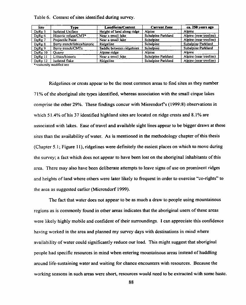
Ridgelines or crests appear to be the most common areas to find sites as they number
71% of the aboriginal site types identified, whereas association with the small cirque lakes
comprise the other 29%. These findings concur with Mierendorfs (1999:8) observations in
which 5 1.4% of his 37 identified highland sites are located on ndge crests and 8.1% are
associated with lakes. Ease of travel and available sight lines appear to be bigger draws at these
sites than the availability of water. As is mentioned in the rnethodology chapter of this thesis
(Chapter 5.1; Figure 1 1), ridgelines were definitely the easiest places on which to move during
the survey; a fact which does not appear to have been lost on the aboriginal inhabitants of this
area. There may also have been deliberate attempts to leave signs of use on prorninent ridges
and heights of land where others were later likely to fiequent in order to exercise "CO-rights" to
the area as suggested earlier (Mierendorf 1999).
The fact that watrr does not appear to be as much a draw to people using mountainous
regions as is commonly found in other areas indicates that the aboriginal usen of these areas
were likely highly mobile and confident of their surroundings. I can appreciate this confidence
having worked in the area and plamed my survey days with destinations in mind where
availability of water could significantly reduce Our load. This might suggest that aboriginal
people had specific resources in mind when entering mountainous areas instead of huddling
around life-sustaining water and waiting for chance encounters with resources. Because the
working seasons in such areas were short, resources would need to be extracted with some haste.
88
The treeline transitional zone also appears to be an area which attracted people. Only two
sites (25%) were found in areas which were likely true alpine at the time of their creation,
whereas the other six (75%) were probably situated in subalpine parkland or in the alpine near
treeline (the treeline transitional zone). These results concur with Mierendorfs (1999) findings,
however, his focus remains on the distinction of two rather than three categones of vegetation
zones. By concentrating on only the subalpine and alpine zones, he does not indicate whether
these contexts were expected to have been the same at the time of the site's creation. He does
find, however, that 89% of his sites fa11 within the subalpine, while only 11% are located in the
true alpine. 1 would argue that many of these subalpine sites likely also fa11 within the treeline
transitional zone. Such areas would have offered ease of travel, good sight lines, as well as
shelter, fuel, and food. Determining exactly where these zones would have occurred for the time
period we seek should result in the discovery of the highest concentration of sites.
In conclusion 1 would suggest that the sites identified in this research represent two very
separate time periods. The early historic period, as is indicated by the presence of berry trench
processing sites (Sites DgRg 8 and DgRg 9; Chapters 6.4 and 6.5), and a separate, earlier period
represented by the sites which held lithic rnaterials. During both time periods, however, a similar
ecotone was probably sought - the treeline transitional zone. Al1 sites also appear to be
connected by trails associated with prominent ridgelines, not necessarily close to water. People
appear to have been farniliar enough with their environment to venture away from water in order
to collect or hunt the resources they sought in order to take advantage of a relatively short
window in which to exercise their tasks.
Bibliography
Alexander, Diana 1994 A Heritage and Sustenance Inventory of the Paviiion Creek Valley, southwestern B.C.
Report prepared for the Ainsworth Lumber Company and the Ts'kw'aylaxw First Nations Band. Unpublished consultant's report on file with the Heritage Resource Centre, Victoria.
Alexander, Diana and R.G. Matson 1986 Preliminary Report on Potato Mountain Archaeology Project, 1985. Unpublished report
submitted to the British Columbia Heritage Conservation Branch, Victoria. 1987 Report on the Potato Mountain Archaeological Project (1 985). Unpublished report
submitted to the British Columbia Heritage Conservation Branch, Victoria.
Alexander, Diana, Robert Tyhurst, Linda Burnard-Hogarth and R.G. Matson 1985 A Preliminary Ethnoarchaeological Investigation of the Potato Mountain Range and the
Eagle Lake area. Unpublished report submitted to the British Columbia Heritage Conservation Branch, Victoria, the Canadian Ethnic Studies Program, and the Nemiah Valley Indian Band Council.
Ames, Kenneth M. and Herbert D.G. Maschner 1999 Peoples of the Northwest Coast: Their Archaeoiogv and Prehistory. Thames & Hudson,
London.
Axas Consulting Archeologists Ltd. 1999 Archaeological Research in Garibaldi Park for the Squamish First Nation. Published
Bailey, Jeff 1995 An Archaeological Impact Assessment relating to Ainsworth Lumber Co. Ltd.'s
proposed Timber Harvesting Activities within Cutting Permits 555,584, and 560 in the Maiden Creek Watersked, near Clinton, B.C. Permit No. 1994- 1 1 7. Unpublished consultant's report on file with the Archaeology Branch of the Ministry of Small Business, T O U ~ S ~ and Culture.
Bergland, Eric O. 1984 Olympic National Park Archeological Base Map Study: Summary Report to
Supenntendent Chandler. Report on file, Cultural Resources Division, Pacific Northwest Region, National Park Service, Seattle.
1 9 8 6 Arc haeological Investigations in Mount Rainier National Park, Washington. Prepared for U.S. Department of the Interior, National Park Service, Pacific Northwest Region. Seattle.
1988 Archaeological Test Excavations at the Berkley Rockshelter Site (45-PI-303), Mount Rainier National Park, Washington. SRD Report of Investigations No. 1. Prepared for U.S. Department of the Interior, National Park Service, Pacific Northwest Region, Seattle. Sidda Research and Developrnent. Eugene, Oregon.
Boas, Franz 1894 The Indian Tribes of the Lower Fraser Valley. In On the Northwestern Tribes of
Canada. Ninth Report of the Cornmitter Report of the 641h Meeting of the British Association for the Advancement of Science, pp. 424-449.
Booth, D.B. 1987 Timing and processes of deglaciation along the southem margin of the Cordilleran ice
s heet. In North America and adjacent Oceans during the last Glaciation, edited by W.F. Ruddiman and H.E. Wright Jr., pp. 7 1-90. Geological Society of America, Boulder.
Borden, Charles 1960 DjRi 3, an Early Site in the Fraser Canyon, British Columbia. Contributions !O
Anthropology, National Museum of Canada Bullefin, No. 162, pp. 10 1 - 1 1 8.
1975 Origins and Development of Early Northwest Coast Culture to About 3000 B.C. National Museum of Man Mercury Series, Archaeological Survey of Canada Paper No. 445, National Museum of Canada, Ottawa.
Bouchard, Randy and Dorothy Kennedy 1985 Indian Land Use and Indian History of the Stein River Valley, British Columbia. Report
to I.R. Wilson Consultants Ltd. and British Columbia Forest Products Ltd.
Brooke, R.C., E.B. Peterson, and V.J. Krajina 197 1 n e Subalpine Mountain Hemlock Zone: Ecology of Western North America, Volume 2,
Number 2. University of British Columbia, Vancouver, B.C.
Brown, William C. 1 9 1 4 Old Fort Okanogan and the Okanogan Trai 1. Oregon Historical Quarteriy 1 5 : 1 -3 8.
Bryan, Alan 1980 The Stemmed Point Tradition: An Early Technological Tradition in Western North
America. In Anthropological Papers in Memory of Earl H. Swanson Jr., edited by L. B. Harten, C.N. Warren, and D.R. Tuohy, pp. 77-1 07. Idaho Museum of Natural History, Pocatello.
1988 The Relationship of the Stemmed Point and Fluted Point Traditions in the Great Basin. Nevada Siate Museum Anthropological Papers 2 1 53-74,
Burtchard, Greg C. 1998 Environment, Land-Use & Archaeology of Mount Rainier National Park, Washington.
Manuscript prepared for U.S. Department of the Interior, National Park Service. Internat ional Archaeological Research Institute Inc., Seattle.
Bush, Kelly, R. 1997 A Comparison of Archaeological Data Recovery Techniques in the Skagit River Valley,
Southwestern British Columbia. Unpublished Master's Thesis. University of Western Washington, Bellingham.
1998 Archaeological Investigations at DgRg 4, Upper Skagit River Valley, southwestern B.C. Permit No. 1997- 180. Unpublished report submitted to the Archaeology Branch of the Ministry of Small Business, Tourkm and Culture, Victoria.
Carlson, Keith, Thor 1997 First Contact: Smallpox "a sickness that no medicine could cure, and no person escape".
In You Are Asked to Witness: The Sto:lo in Canada 's Pacifie Coast History, edited by Keith Thor Carlson, pp. 27-40. Sto:io Heritage Trust, Chilliwack.
Chatters, James C. 1986 The Wells Reservoir Archaeological Pmject Volume 1: Summary of Findings.
Archaeological Report 86-6. Central Washington Archaeological Survey, Central Washington University, Ellensburg.
Clague, John J. 198 1 Late Quaternary Geology and Geochronology of British Columbia, Part 2: Summary
and Discussion of Radiocarbon-dated Quatemary History. Geological Survey of Canada Paper 80-13, Ottawa
Collins, June McCormick 1 974 Valley of the Spirits, the Upper Skagi t Indians of Western Washington. Arnerican
Ethnological Society, Monograph 56. University of Washington Press, Seattle.
Draffen, George, Ken Favrholdt, Mitch Friedman, and Bob Mierendorf 1993 History of the Greater North Cascades Ecosystem. In Cuscadia Wild: Protecting an
International Ecosystem, edited by Mitch Friedman and Paul Lindholdt, pp. 22-48. Greater Ecosystem Alliance and Frontier Publishing, Seaside, Oregon.
Duff, Wilson 1 95 2 The Upper Stalo Indians of the Fraser Valley, British Columbia. Anthropology in
British Columbia, Memoir No. 1. British Columbia Provincial Museum, Victoria.
Eisner, J. 197 1 Skagit Valley Survey. Unpublished consultant's report submitted to the Heritage
Conservation Branch, Victoria.
EIdridge? Morley 1996 Archaeological Impact Assessment of Paradise Creek Area Cutblocks in the Lillooet
Forest District. Permit No. 1996-096. Report on file with the Heritage Resource Centre, Ministry of Small Business, Tourism and Culture, Victoria.
Eldridge, M. and D. McLaren 1998 Stave Reservoir Erosion Study, Archaeological Notes. Prepared by Miliennia Research
Limited for B.C. Hydro, Permit No. 1998-101, Sto:lô Permit No. 1998-01 1. Report on file with the Culture Library, Ministry of Srnall Business, Tourism, and Culture. Victoria.
Elmendorf, William W., and Wayne Suttles 1960 Pattern and Change in Halkomelem Salish Dialects. Anthropological Linguistics 2(7): 1-
32.
Filloon, Ray 1952 Huckleberry Pilgrimage. Pacifc Discovery 5(3):4- 13.
Fleischner, Thomas L. and Saul Weisburg 1993 Tidewater to Timberline, Forest to Steppe: Natural History of the Greater North
Cascades Ecosystem. In Cascadia Wild: Protecting an International Ecosystem, edited by Mitch Friedman and Paul Lindholdt, pp. 4-2 1. Greater Ecosystem Alliance and Frontier Publishing, Seaside, Oregon.
Franck, Ian C. 1997 Preliminary Archaeological Reconnaissance of nine proposed Timber Sale Licences
within TSL Area A45520 near the Yalakom River, Lillooet Forest District. Non-permit consultant's report submitted to the Lillooet Tribal Council and Lillooet Forest District.
Franck, Ian C., Jeff Bailey, Peter S., Merchant, Diana M. Alexander and Mike K. Rousseau. 1994 The 1993 Archaeological Investigations at the Fraser-Hope Bridge Sites (Di% I and 9 9 ,
Hope, Southwestern B.C. Permit No. 1993-102. Unpublished consultant's report on file at the Heritage Resource Centre, Ministry of Small Business, Tourkm and Culture, Victoria.
Franck, Ian and Dave Schaepe 1999 Archaeological Inventory of Silverhope Creek fiom Silver Lake to Silverhope: A Pilot
Study. Permit No. 1999-030, St6:lô Permit No. 1999-008. Report on file with the Heritage Resource Centre, Ministry of Small Business, Tourism and Culture, Victoria.
Franck, Ian C., R.J. Muir, K.R. Bush 1997a Archaeological Data Gap Analysis of Nine LRMP Sub-Regions in British Columbia.
Report prepared for the Archaeology Branch of the Ministry of Srnall Business, Tounsm and Culture, Victoria.
1997b Archaeological Data Gap Analysis of Thirty-four Forest Districts within British Columbia. Report prepared for the Abonginal Affairs Branch of the Ministry of Forests, Victoria.
Fraser, Simon 1 960 The Letters and Journals of Simon Fraser, 1806- 1808, edited by Kaye Lamb.
Macmillan Company of Canada, Toronto.
Fulkerson, AM C. 1988 Predictive Modeling of Abonginal Sites in the Methow River Area: Deductive and
Inductive Approaches. Unpublished Master's thesis, Department of Anthropology, Washington State University, Pullman.
Galm, Jeny R. and Ruth A. Masten 1985 Avey 's Orchard: Archaeological Investigation of a Lote Prehistoric Columbia River
Comrnunity. Reports in Archaeology and History 100-42. Archaeological and Histoncal Services, Eastern Washington University, Cheney, Washington.
Gibbs, George 1877 Tribes of Western Washington and Northwestern Oregon. US Geographical and
Geo logical S w e y of the Rocky Mountain Region. Contributions to Northern American Ethnology 1 : 157-24 1.
Grabert, Garland F. 1968 North-central Washington Prehistory: A Final Report on Salvage Archaeology in the
Wells Resmoir-Part 1. University of Washington Reports in Archaeolop, Department of Anthropology, University of Washington, Seattle.
1975 An Archaeological Reconnaissance of the Newhalem Vicinity, Washington. Department of Sociology and Anthropology, Western Washington State University, Bellingham, Washington.
Grabert, Gariand F. and E. Richard Chesmore, Jr. f 979 Archaeological Investigarions at 45 WH81, Newhalem, Washington. Reports in
Archaeology No. 10, Department of Anthropology, Westem Washington University, Bellingham, Washington.
Grabert, Garland F. and D.J. Pint 1 978 An Archaeologica l Reconnaissance and Cultural Resource Inventory of the North
Cascades Recreational Area. Reports in Archaeology No.5, Department of Anthropology, Westem Washington University, Bellingharn, Washington.
Gramly, Richard M. 1993 The Richey Clovis Cache: Earliest Americans A fong the Columbia River. Persirnmon
Press, Buffalo, New York.
Haley, Shawn.D. 1987 The Pasika Complex Cobble Reduction Strategies on the Northwest Coast. Unpublished
P h.D. Dissertation, Department of Archaeology, Simon Fraser University, Bumaby. 1996 The Pasika Complex Revisited. In Early Human Occupation in British Columbia.
Edited by Roy L. Carlson and Luke Dalla Bona, pp.5 1-64. UBC Press, Vancouver.
Harris, Cole 1994 Voices of disaster: Smallpox around the Strait of Georgia n 1782. Ethnohistory
4 1(4):59 1-626.
Hartrnan, Glenn, D. 1 980 An Archaeological Evaluation of the Kaner Ridge Site 45KT364, Naches Ranger
District. Central Washington Archaeological Survey, Ellensburg, Washington.
Hebda, R.J. 1995 British Columbia Vegetation and Climate History with focus on 6 KA BP. Geographie
physique et Quaternaire 49: 55-79.
Hedlund, Gerald C. 1986 Test Excavations of the Naches Lithic Scatter, White River Ranger District, Mount
Baker-Snoqualmie National Forest, Washington. Prepared for the Mount Baker-Snoqualmie National Fore5t under contract No. 43-05M6-0433.
HiIl-Tout, Charles 1900 Notes on the N'tlaka' pamuQ of British Columbia, a Branch of the great Salish Stock of
North Amenca. In Report of the British Association for the Advancement of Science, Dover, pp. 500-584 and republished as "Notes on the Ntlakapamuq.. ." in The Salish People ( 1 978), Edited by Ralph Maud, pp. 4 1 - 1 30. Talonbooks, Vancouver.
1903 Ethnological Studies of the Mainland Halkorne 'lem, a division of the Salish of British Columbia. British Association for the Advancement of Science, Dover.
Hotland, S.S. 1976 Landf~rrns of British Columbia: A Physiographic Outline. Bulletin 48, British Columbia
Department of Mines and Petroleum Resources, Victoria.
HoIlenbeck, Jan L. and Susan L. Carter 1 986 A Cultural Resource Overview : Prehistory and Ethnography , Wenatchee National
Ignace, Marianne 1995 Maiden Creek Watershed Sustenance Study: Traditional Secwepemc Land Use. Non-
permit report prepared for the Bonaparte and Whispering Pines Bands. Submitted to the Heritage Resource Centre, Ministry of SmaIl Business, Tourism and Culture, Victoria.
Irvine, C.M. 1973 Prelirninary Report on Excavations at DjRi 7 (South Yale Site) 30 April to 29 May 1973.
Manuscript on file at the Resource Management Division, British Columbia Heritage Conservation Branch, Victoria.
Joseph, L. and E. Bikadi 1998 An Archaeological Survey of the Callahan Lake area in the Coast Mountains near
Whistler, B.C. Report prepared for Creekside Resources Ltd., Mount Cume, British Columbia.
Kidd, R.S. 1968 Report on archaeological site survey of the lower Fraser River valley, 1963. Paper No.
5, Contributions to Anthropology V1:2:208-247. National Museum of Canada Bulletin 224, Ottawa.
Kuhnlein H. and N. Turner 199 1 Traditional Plant Foods of Canadian Indigenous Peoples: Nutrition, Botany and Use.
Gordon and Breach, Philadelphia.
Kuijt, Ian 1989 Subsistence Resource Variability and Culture Change dunng the Middle-Late Prehistoric
Cultural Transition on the Canadian Plateau. Canadian Journal of Archaeology 13:97- 1 17.
Laforet, Andrea and Amie York 1 998 Spuzzum: Fraser Canyon Histories. 1808- 1 93 9. UBC Press, Vancouver.
Leclair, Ronald 1973 Investigations at the Maurer Site, an early pithouse manifestation in the Upper Fraser
Valley: Preliminary report. Unpublished report on file with the Heritage Resource Centre, Ministry of Small Business, Tourism and Culture, Victoria.
1976 Investigations at the Maurer Site near Aggassiz. in Current Research Reports, Edited by. Roy Carlson, pp.33-42. Simon Fraser University, Department of Archaeology, Publication No.3. Burnaby.
Lepofsky, Dana, Douglas Brown, Sandra Momson, and Natasha Lyons 1999 Report on the 1998 Excavations at the Scowlitz Site ( D m 16) Fraser Valley, B.C.
Permit No. 1998-103. Unpublished report submitted to the Archaeology Branch of the Ministry of Small Business, Tourism and Culture, Victoria.
Lepofsky, Dana, Douglas Brown, Sandra Momson, and Natasha Lyons 2000 Excavations at the Scowlitz Site (DhRI 16) Fraser Valley, Bntish Columbia. Submitted
to Journal of Field Archaeology.
Lewarch, D.E. and J.R. Benson 199 1 Long-Term Land Use Patterns in the Southem Washington Cascade Range.
Archaeology in Washington 3 :27-40.
Mack, C.A. 1989 Prehistoric Upland Occupations in the Southem Washington Cascades. In Archaeology
in Washington 1:49-57. 1992a In Pursuit of the Wild Vaccinium-Huckleberry Processing Sites in the Southern
Washington Cascades. Archaeology in Washington 4:3- 16. 1992b Report of Archaeological Testing at the Ice Cave Site (45SA3O l), Gifford Pinchot
National Forest. Mt. Adams Ranger District, Gifford Pinchot National Forest, Vancouver, Washington.
1993 Report of Archaeological Testing at the Pointless Site (45SA300), Gifford Pinchot National Forest, Vancouver, Washington.
Mack, C.A and R.H. McClure 1 998 Vaccinium Processing in the Washington Cascades- Ecology. Feature Structure and
Distribution. Paper presented at the 63rd Annual General Meeting of the Society for Ameriran Archaeology, Seattle, Washington.
Maclachlan, Morag (ed.) 1998 The Fort Langley Journals, 1827-30. UBC Press, Vancouver.
Mann, D.H. and T.D. Hamilton 1995 Late Pleistocene and Holcene Paleoenvironments of the North Pacific Coast.
Quaternary Science Reviews 1 4:449-45 7.
Mathewes, R.W. 1973 A Palynological Study of Postglacial Vegetation Changes in the University Research
Forest, southwestem Bntish Columbia. Canadian Journal of Botany 5 1 :2O85-2 103.
1984 Paleobotanical evidence for Climatic Change in southern British Columbia during the Late-Glacial and Holocene. In CIimate Change in Canada 5: Crirical Periods in the Quaternary CZimate History of northwestern North America., Edited by C.R. Hamngton, pp. 397-422. Geological Survey of Canada, Ottawa.
1993 Evidence for Younger Dryas-age Cooling on the North Pacific Coast of America. Quaternary Science Reviews 1 2: 3 2 1 -33 1.
Mathewes, R.W. and L. E. Heusser 198 1 A 12,000 year old Palynological Record of Temperature and Precipitation Trends in
southwestern British Columbia. Canadian Journal of Botany 59: 707-7 10.
Mathewes, Rolph W., L.E. Heusser, and R.T. Peterson 1993 Evidence for a Younger Dryaas-like Cooling Event on the British Columbia Coast.
Geology 21:lOl-104.
Maxwell, J., T. Christensen and D. A. Owens 1998 DhRo-26, Hayward Reservoir; 1998 Archaeological Training & Site Evaluation.
Prepared by Miliennia Research Limited for BC Hydro, Kwantlen First Nation, Sto:lo Nation, B.C. Archaeology Branch, Permit No. 1998-305 and 1998-036. North Saanich, B.C.
McClure Jr., R.H. 1989 Alpine Obsidian Procurement in the Southem Washington Cascades: Preliminary
Research. In Archaeology of Washington, 1 59-69. 1992 An Archaeological Assessment of the Beech Creek Site (4SLE415), Gifford Pinchot
National Forest. USDA Forest Service, Region Six. Gifford Pinchot National Forest, Vancouver, Washington.
McLaren, D. 1998 Report for the Hayward Lake Trail Archaeological Inventory und Impact Assessment
Project. Prepared by Millennia Research, Permit No. 1997-328. Report on file with the Culture Library, Ministry of Small Business, Tourism, and Culture. Prepared for B.C. Hydro, North Saanich, B.C.
McLaren, D., J. Stafford and T. Dandurand 1998 Report for the Stave River Delta Archaeological Inventory and Impact Assessment
Project. Prepared for B.C. Hydro by Kwantlen First Nation and Millennia Research, Permit No. 1997-328. Report on file with the Culture Library, Ministry of Small Business, Tourism, and Culture, Victoria, B.C.
McLaren, D. and J. Maxwell 1998 Final Report for the Hayward Reservoir Archaeological Inventory and Impact
Assessment Project. Prepared for B.C. Hydro by Kwantlen Fint Nation and Miliennia Research, Permit No. 1997-094. Report on file with the Culture Library, Ministry of Small Business, Tourism, and Culture, Victoria, B.C.
McLaren, D., T. Gludo, M. Eldndge, T. Christensen and D. A. Owens-Baird 1997 Report on the Stave Reservoir Archaeological Inventory and Impact Assessment Project.
Prepared for B.C. Hydro by Miliennia Research and Kwantlen First Nation, Permit No. 1997-036. Report of file with the Culture Library, Ministry of Small Business, Tourisrn, and Culture, Victoria, B.C.
McLaren, Duncan, David O'Regan, Joel Kinzie and Morley Eldndge 1996 Skoonka Creek & Murray Creek Drainage Areas Archaeological Impact Assessment of
Cutblocks. Permit Nos. 1996- 17 1 and 1996-168. Report on file with the Heritage Resource Centre, Ministry of Small Business, Tourism and Culture, Victoria, B.C.
Mehringer, Peter J. Jr. 1 98 8 Weapons of Ancient Americans. National Geographic 1 74(4): 500-503.
Mehringer, Peter J. Jr. and Franklin J. Foit 1990 National Geographic Research 6(4):495-503.
Meidinger, D. and J. Pojar 1 99 1 Ecosystems of British Columbia. B.C. Ministry of Forests, Victoria, B.C.
Meltzer, David J. and Robert C. Dunnell 1987 Fluted Points from the Pacifie Northwest. Current Research in the Pleistocene 4, Centre
for the Study of Early Man, University of Maine, Orono.
Merchant, Peter 1998 Archaeologicai Impact Assessment of FSR 9 16 1 and Cutting Permit Area A 18703
within the Lillooet Forest District. Permit No. 1998-265. On file with the Archaeology Branch of the Ministry of Small Business, Tounsm and Culture, Victoria, B.C.
Merchant, P. and M. Rousseau 1995 An Archaeological Impact Assessment of the Ministry of Forests' Kamloops Forest
District, TSL A45506, A5541 1, Ad412, A45504, and A45505 near Veasey Lake, southwestern B.C.. Permit No. 1995-236. Report on file with the Heritage Resource Centre, Ministry of Small Business, Tourism and Culture, Victoria, B.C.
Mierendorf, Robert R. 1986 People of the North Cascades. North Cascades National Park Service Cornplex, Cultural
Resources Division, Seattle, Washington. 1987a A Progress Report on the Archaeology of Upper Skagit River Valley, North Cascade
Range, Washington. Report on file, North Cascades National Park, Pacific Northwest Region, National Parks Service, Seattle.
19876 Archaeological Reconnaissance in the Near Timberline of the North Cascades National Park. North Cascades National Park, Pacific Northwest Region, National Park Service, Seattle. Paper presented at the 4 0 ~ Annual Northwest Anthropological Conference, Gleneden Beach, Oregon.
199 1 Final Report of Intensive and Reco~aissance-Level Archaeological Suveys in the Upper Skagit River Basin, Washington. National Park Service, North Cascades National Park, Sedro Woolley, Washington. Unpublished report submitted to Seattle City Light, Bellevue, Washington.
1993 Chert Procurement in the Upper Skagit River Valley of the Northem Cascade Range Ross Lake National Recreation Area, Washington. National Park Service, Seattle, Washington.
1997 An Exploratory Archeological Survey for Glassy Volcanic Rock Sources in the Silver Creek Watershed. Report Submitted to the Skagit Environmental Commission, Seattle, Washington.
1998 Modelling Prehistoric Forager Use of Alpine Tundra Zones of the Northem Cascades Range, Pacific Northwest. Unpublished paper presented at the 63" Annual Meeting of the Society for American Archaeology, Seattle, Washington.
1999 Precontact use of Tundra Zones of the Northern Cascades Range of Washington and British Columbia. Archaeology in Washington 7:3 :Z3.
Mierendorf, Robert R. and Sheila Bobalik 1 983 Lithic Analysis. In Cultural Resources of the Roc@ Reach of the Columbia River, Vol.
II, edited by Randall F. Schalk and Robert R Mierendorf, pp. 603-618. Project Report No. 1. Center for Northwest Anthropology, Washington State University, Pullman, Washington.
Mierendorf, Robert R. and David J. Harry 1993 ResuIts of a Subsurface Archaeological Survey on a Pleistocene Terrace in North
Cascades National Park Service Complex. Archaeology in Washington 5:39-5 1 .
Mierendorf, Robert R., David J. Harry, and Greg M. Sullivan 1998 An Archaeological Site Survey and Evaluation in the Upper Skagit River Valley,
Whatcom County Washington. Technical Report NPS/CCCNOCA/CRTR-98/O 1, North Cascades National Park Service Complex, Sedro Woolley, Washington,
Mierendorf, Robert R. and Craig E. Skinner 1997 Correlation of Artifact and Source Obsidian, North Cascades National Park Service
Complex, Washington. Paper presented at the 50" Annual Northwest Anthropological Conference, Program with abstracts, pp. 49-50, Central Washington University, Ellensburg, Washington.
Mierendorf, Robert R. and J. Thompson 1 986 An Assessment of the Ef'Eects of Endowment Commission Projects to Archaeological
Remains in the Ross Lake National Recreation Area. Manuscript on file, Pacific Northwest Region, Nation Park Service, Seattle, Washington.
Millennia Research 1994 Investigation of the Mt. Slesse Air Crash Site. UnpubIished consultant's report on file
with the Archaeology Branch of the Ministry of Small Business, Tounsm and Culture, Victoria, B.C.
Millennia Research Ltd. and Kwantlen Nation 1998 Final Report for the Hayward Reservoir Archaeological Inventory and Impact
Miller, Robert B. and Samuel A. Bowring 1990 Structure and Chronology of the Oval Peak Batholith and adjacent Rocks: Implications
for the Ross Lake Fault Zone, North Cascades Washington. Geological Society of America Bulletin, I02:1361-1377.
Miss, Christian J. and Margaret A. Nelson 1995 Data Recovery at the Mule Spring Site, 45-KI-435, King County, Washington.
Submitted to Mount Baker-Snoqualmie National Forest. Northwest Archaeological Associates, Inc. Seattle, Washington.
Mitchell, Donald H. 1963 Esilao - A Pit House Village in the Fraser Canyon, British Columbia. Unpublished
M.A. Thesis, Department of Anthropology and Sociology, University of British Columbia. 1965 Preliminary Excavations at a Cobble Tool Site (DjRi 7) in the Fraser Canyon, British
Columbia. Anihropology Papers No. 10, National Museum of Canada, Ottawa.
Mitchell, Donald H. and David L. Pokotylo 1996 Early Period Components at the Milliken Site. In Early Human Occupation in British
Columbia, edited by Roy L. Carlson and Luke Dalla Bona, pp.65-82. UBC Press, Vancouver.
Nagorsen, David, W., Grant Keddie and Tanya Luszcz 1996 Vancouver Island Marmot Bones From Subalpine Caves: Archaeological and Biological
Significance. B.C. Parks Occasional Paper No. 4.
Nelson, Charles G. 1973 Prehistoric Culture Change in the Intermontane Plateau of Western North Amenca. In
The Explanation of Culture Change: Models in Prehistory, edited by C . Renfiew, pp. 37 1- 390. Duckworth, London.
Norton, Helen, Robert Boyd and Eugene S. Hunn 1984 The Klickitat Trail of South-Central Washington: A Reconstruction of Seasonally Use
Resource Sites. In Prehistoric Places in the Southern Northwest Coast. Edited by Robert E. Greengo, pp. 12 1 - 152. Thomas Burke Memonal Washington State Museum, University of Washington, Seattle.
Parish, Robert, Ray Coupé and Demis Lloyd : 996 Plant of Southern Interior British Columbia. Ministry of Forests and Lone Pine
Publishing, Vancouver.
Pellatt, Marlow Gregory 1996 Postglacial changes in vegetation and climate near treeline in British Columbia.
Unpublished Ph.D. Thesis. Department of Biological Sciences, Simon Fraser University, Burnaby, B.C.
Pellatt, Marlow Gregory and R.W. Mathewes 1994 Paleoecology and Postglacial Treeline Fluctuations on the Queen Charlotte Islands,
Canada. Ecoscience 1 :7 1-8 1.
Pellatt, Marlow G., Michael J. Smith, R.W. Mathewes, and Ian R. Walker 1998 Palaeoecology of Postglacial Treeline Shi& in the Northem Cascade Mountains,
Peteet, D. 1 995 Global Younger Dryas? Quatemary International 28:93- 1 04.
Pielou, E.C. 1991 AftertheIceAge: n e Return ofL$eto GlaciatedNorth America. Universityof
Chicago Press, Chicago.
Pojar J. and K. Klinka 1983 Mountain Hemlock Zone. In Forestry Handbook for British Columbia, pp.292-296.
Faculty of Forestry, University of British Columbia, Vancouver, B.C.
Pojar, I. and A. MacKinnon 1994 Plants of Coastal British Columbia including Washington, Oregon and Alaska. Lone
Pine Publishing, Vancouver, B.C.
Pojar, J . and D. Meidinger 199 1 Ecoysystems of British Columbia. Ministry of Forests, Research Branch, Special Report
Series No.6, Victoria.
Pokotylo, David L. 1976a Preliminary Archaeological Impact Assessment of the Proposed Upper Hat Creek
Development. Report submitted to the Archaeological Sites Advisory Board of Bntish Columbia.
lW6b Archaeological Resource Inventories: Two Case Studies from the British Columbia Interior Plateau. Canadian Archaeological Association Bulletin 8: 147-6 1 .
1977 Preliminary Results of an Archaeological Surface Survey in the Upper Hat Creek Valley, Bntish Columbia. Datum, Newsletter of the Archaeological Sites Advisory Board of British Columbia, Victoria, 3(1):4-9.
1978 Lithic Technology and Settlement Patterns in Upper Hat Creek Valley, Bntish Columbia. Unpublished doctoral dissertation. Department of Anthropology and Sociology, University of B.C.
1979 An Archaeological Impact Assessment of the Proposed Hat Creek Thermal Electric Development; Phase 1. In Annual Report for the Year 1976. Activities ofthe Provincial Archaeologist 's ODce and Selected Research Reports, edited by B. Simonsen. Govemment of the Province of British Columbia, Ministry of Provincial Secretary and Government Services, Victoria. B.C.
198 1 Towards an Understanding of Prehistoric Upland Settlement in the British Columbia Southem Interior Plateau. In Networks of the Past: Regional Interaction in Archaeology, edited by P.D. Franci, F.J. Kense and P.G. Duke, pp. 379-396. The Archaeological Association of the University of Calgary, Calgary.
1985 Archaeological Reconnaissance of the Blustry Mountain - Cairn Peak Locality, British Columbia. Report submitted to the Bntish Columbia Hentage Conservation Branch, Victoria, B.C.
Pokotylo, David L. and Patricia D. Beime 1978 Preliminary Inventory, Assessment and Impact Evaluation of Cultural Heritage
Resources in the Upper Hat Creek Valley, B.C. Unpublished report submitted to B.C. Hydro and Power Authority and the British Columbia Heritage Conservation Branch, Victoria.
Porter, S C . and G.H. Denton 1967 Chronology of Neoglaciation in the North American Cordillera. American Journal of
Science 265: 1 77-2 10.
Porter, Stephen C., Kenneth L. Pierce, and Thomas D. Hamilton 1983 Late Wisconsin Mountain Glaciation in the Western United States. In Late-Quatemary
Environments, Vol. 1. The Lake Pleisiocene, edited by H.E. Wright Jr., pp. 7 1- 1 1 1. UBC Press, Vancouver.
Reirner, Rudy 1998 Squamish Aipine Resource Use. Paper Presented at the 3 ln Annual General Meeting of
the Canadian Archaeology Association, May 6st-9", Victoria, B.C. 1999 The Results of Archaeological Inventory of the Area Beîween Elfm and Mamquam
Lakes. Garibaldi Provincial Park, southwestern B. C. Report on file at the Ministry of Small Business, Tourism and Culture, Archaeology Branch, f ennit No. 1998-260, Victoria, B.C.
Rice, David G. 1964 Indian Utilization of the Cascade Mountain Range in South-Central Washington. The
Washington Archaeologist 8(1):5-20. 1965 Archaeological Test Excavations in Fryingpan Rockshelter, Mount Rainier National
Park. Washington State University Laboratory of Anthropology Report of Investigations No. 33. Pullman, Washington.
1972 The Windust Phase in Lower Snake River Region Prehistory. Washington Stafe University. Laboratoy of Anthropology. Reports on Investigations 50. Pullman, Washington.
Rice, H.S. 1985 Native American Dwellings and Attendant Structures of the Southern Plateau. Eastern
Washington University Reports in Archaeology and History. Report Number 100-44. Archaeological and Historical Services, Cheney, Washington.
n.d.a. An Archaeological Survey of the Proposed Roland Point Road and Recreational Development in the Ross Lake National Recreation Area. Manuscript on file, National Park Service, Pacific Northwest Region, Seattle, Washington.
n.d.b. The Ross High dam Archaeological Survey. Manuscript on file, National Park Service, Pacific Northwest Region, Seattle, Washington.
Rousseau, M.K. 1987a Cornwall Hills Summit Heritage Project: Site Inventory and Test Excavation Results. A
Report prepared for The British Columbia Heritage Trust. Ministry of Tourism, Recreation and Culture, Parliament Buildings, Victoria B.C.
1987b Prehistoric Resource Use on Cornwall Hills Surnmit. The Mkiden 19(5) 6-9.
Rousseau, Mike K. 1988 Heritage Resource Inventory and Mitigation for the Ross Lake Provincial Park
Campground Expansion Project, Upper Skagit Valley, British Columbia. Report Submitted to the Skagit Environmental Endowment Commission. One file with the Culture Library, Victoria, B.C.
1989 The 1988 Results of Archaeological Investigations In The Upper Oregon Jack Creek Valley and On Cornwall Hills Sumrnit Near Ashcroft, B.C. A Report prepared for The British Columbia Heritage Trust. Ministry of Tourism, Recreation and Culture, Parliament Buildings, Victoria B.C.
Rousseau, Mike, Ian, C. Franck, and Diana M. Alexander 1993 An Archaeological Impact Assessment for the Proposed Cayoosh Resort Recreational
Development Project Area, Melvin Creek Valley, Southwestern B.C. Report on File at the Ministry of Small Business, Tourism and Culture, Archaeology Branch, Victoria, B.C.
Ryder, J. M. 1998 Stave Reservoir Erosion Study (Erosion Study - Stave River Valley, Phase 1). Prepared
by J.M. Ryder and Associates, Terrain Analysis Inc. for B.C. Hydro, Permit No. 1998- 101, Sto:lô Permit No. 1998-01 1. Report on file with B.C. Hydro, Vancouver, B.C.
Ryder, June M. and J.J. Clague 1989 British Columbia Quaternary Stratigraphy and History, Cordilleran Ice Sheet. in
Chapter I of Quaternary Geology of Canada and Greenland, Geology of Canada, pp.48-58. Geological Survey of Canada, Ottawa.
Salo, Lawrence V. 1987 Similkameen River Multipurpose Project Feasibility Study, Cultural Resource
Reconnaissance. Report submitted to U.S. Army Corps of Engineers, Seattle, Washington.
Samuels, Stephen H. 1993 The Archaeology of Chester Morse Lake: Long-Term Human Utilizatim of the Foothills
in the Washington Cascade Range. Project report No. 21. Center for Northwest Anthropology, Department of Anthropology, Washington State University, Pullman, Washington.
Schalk, Randall F. and Gregory C. Cleveland 1983 A Chronological Perspective in Hunter-Gatherer Land Use Strategies in the Columbia
Plateau. In Cultural Resource Investigations for the Lyons Ferry Fish Hatchery Project, Near Lyons Ferry, Washington, edited by F . Schalk, pp. 44-56. Project Report No.8, Laboratory of Archaeology and History, Washington State University, Pullman, Washington.
Schaepe, David 199âa From Plain to Peak: Results of the Chilliwack River Watershed Archaeological
Inventory Study. Permit No. 1997-229. Unpublished report prepared for the Ministry of Forests, Chilliwack Forest District and submitted to the Archaeology Branch of the Ministry of Small Business, Tourism and Culture, Victoria, B.C.
1 998b Recycling Archaeology: Analysis of Matenal fiom the 1973 Excavation of an Ancient House at the Maurer Site. Unpublished Master's Thesis, Simon Fraser University, Department of Archaeology, Burnaby, B.C.
Smith, Allan H. 1988 Ethnography of The North Cascades. Center for Northwest Anthropology. Washington
State University Project Repot Number 7. Pullman , Washington.
Smith, Marian W. 1946 Petroglyph Complexes in the History of the Columbia-Fraser Region. Southwestern
Journal of Anthroplogy 2:306-322. 1950 The Nooksack, the Chilliwack, and the Middle Fraser. Pacipc Northwest Quarterly
4 1 :330-34 1. 1955 Continuity in Culture Contact, Examples fiom Southem British Columbia. Man
115:lOO-105.
Souch, C. 1989 New Radiocarbon Dates for Early Deglaciation fiom the Southeastern Coast Mountains
of British Columbia. Canadian Journal of Earlit Science, 26:2 1 69-2 17 1.
Spafford, Jim, Diana Alexander and Mike Rousseau 1994 An Archaeological Impact Assessment for Twenty-eight of Ainsworth Lumber Company
Limited's proposed Timber Harvesting Blocks and associated Access Roads in the Pavilion Creek Drainage, south central B.C. Permit No. 1994-065. Unpublished consultant's report on file with the Archaeology Branch of the Ministry of Small Business, Tourism and Culture, Victoria.
Staatz, Mortimer, Rowland W. Tabor, Paul L. Weis, Jacques F. Robertson, Ronald M. van Noy, and Eldon C. Pattee
1972 Geology and Mineral Resources of the Northern Part of the North Cascades National Park, Washington. Geological Survey Bulletin 1359. US Govemment Printing Office, Washington, D.C.
Stafford, J. and D. McLaren 1998 Hayward Reservoir Film Location 'Lake Placid' Archaeological Impact Assessment.
Permit No. 1998- 132, prepared for BC Hydro. Victoria, B.C.
Steedman, Elsie Viault (editor) 1930 Ethnobotany of the Thompson Indians of British Columbia. Bureau of American
Eihnology, 4 ~ ' ~ Annuol Report, 1927-1928. pp. 447-522.
Suttles, Wayne 1957 The "Middle Fraser" and "Foothills" Cultures: A Crïticism. Southwestern Journal of
Anthropology 13: 1 56- 1 83. 1998 The Ethnographic Significance of the Fort Langley Journals. In The Fort Langley
Journals, 1827-30. Edited by Morag Maclachlan, pp. 163-2 10. UBC Press, Vancouver.
Swanson, Earl H., Jr. 1959 Archaeological Survey of the Methow Valley, Washington. Tebiwa 2(1):72-87.
Teit, James 1900 The Thompson Indians of British Columbia. American Museum of Natural Hisfory,
Memoir 2:4. New York. 1928 The Middle Columbia Salish. University of Washington Publications in Anthropology,
2:83-128. 1930 The Salishan Tribes of the Western Plateaus. Annuol Report of the Bureau of American
Ethnology, 45:295-396. US Government Pnnting Office, Washington, D.C.
Thompson, Laurence C. 1 979 Salishan and the Northwest. In The Languages of Native America: Historieal and
Comparative Assessment, edited by Lyle Campbell and Marianne Mithun, pp. 692-765. University of Texas Press, Austin.
Turner, Nancy J. 1978 Food Plants of British Columbia Indians. Part 2: Interior Peoples. British Columbia
Provincial Museum, Handbook No. 36, Victoria.
Turner, Nancy, Laurence C. Thompson, M. Terry Thompson, Annie 2. York 1 99 1 Thompson Ethnobo~any: Knowledge and Usage of Plants &y the Thompson Indians of
British Columbia. Royal British Columbia Museum Memoir No. 3, Victoria.
1995 Food Plants of Coastal First Peoples, Royal British Columbia Museum Handbook. UBC Press, Vancouver.
1 997 Food Plants of lnterior Firsi Peoples, Royal Bntis h Columbia Museum Handbook. UBC Press, Vancouver.
Vincent, R. 1 99 8 Hayward Trail West Archaeo logica l In ventory and Impact Assessmenr Projeci. Prepared
by MiIlennia Research Ltd. for B.C. Hydro Report on file with the Culture Library, Ministry of Small Business, Tourism, and Culture. Victoria, BC, Canada. 1998-203.
Vivian, Brian, C. 1989a A Survey and Assessrnent of the Prehistoric Cultural Resources of the Princeton Basin,
Upper Similkameen Valley, British Columbia. Permit No. 1987-9. Report prepared for the Archaeology and Outdoor Recreation Branch, Victoria, B.C.
l989b A Survey and Assessrnent of the Cultural Resources in Cathedra1 Provincial Park, B.C. Permit No. 1988-80. Report prepared for the British Columbia Ministry of Environment and Parks, Southem Interior Region, Kamloops, B.C.
1992 Similkameen Valley Prehistory: Cultural Interaction Across the Interior Plateau of British Columbia and Washington State. Unpublished Master's thesis, Department of Archaeology, University of Calgary, Alberta.
von Krogh, George Heming 1975 The Hope Archaeological Project 1974: Final Report on the site survey in the Hope-
Yale area and archaeological salvage work at DiRj 16, DiRi 24, and DiRi 49. Manuscript on file at the Heritage Resource Centre, Ministry of Small Business, Tourism and Culture, Victoria, B.C.
1980 Archaeological Investigations at the Flood and Pipeline Sites, near Hope, B.C. Occasional Papers Heritage Conservation Branch No. 4, Victoria, B.C.
Warner, B.G. 1984 Late Quatemary Paieoecology of Eastern Graham Island, Queen Charlotte Islands,
British Columbia. Unpublished Ph.D Thesis, Simon Fraser University, Bumaby, B.C.
Wilson, Charles 1 866 Report on the Indian Tribes inhabiting the Country in the Vicinity of the 49h ParaIlel of
North Latitude. Transactions of the Ethnological Society of London 4:275-332. 1 970 Mapping of the Frontier, Charles Wilson 's Diary of the Survey of the 49<h Para fiel,
1858-1862. while Secretary of the British Boundary Commission, edited by George F.G. Stanley. Macmillan of Canada, Toronto.
Zweifel, Matthew K. and Connie S. Reid 199 1 Prehistoric Use of the Central Cascade Mountains of Eastern Washington State: An
Overview of Site Types and Potential Resource Utilization. Archaeology in Washington 3:3- 16.
Notes:
' Pre-contact refers to the period of time before direct contact with Europeans. It includes the "protohistoric" period at which time European goods did begin to influence First Nations lifestyles via trade but was not associated with any sustained physical contact with Europeans. It represents the unrecordeci (Le., not appearing in written histories) period of time in which First Nations lived and used the land. - The irnplernentation of the Forest Practices Code Act (1994) in British Columbia and its section regarding the recognition of archaeological resources has greatly increased the arnount of survey in upland areas at least on a piece meal basis. Unfortunately many predictive models used by forest dismcts to rate which areas must be looked at fail to rate many upland areas with much archaeological potential due mainly to the fact that the survey data used to develop the rnodels is lacking in these areas. ' In the Chilliwack District as of 1997 the only higher elevation zone which had some intensive archeological research conducted in it was the ESSF zone falling entirely in the subalpine (Franck et al. 1997). ' Other Northwest Coast researchers have begun to concentrate, at Ieast partially, on higher elevation biogeoclimatic zones in the Chilliwack District over the last couple of years. This includes D. Lepofsky 's work on aboriginal burning (ongoing) and N. Oakes full coverage survey work at Harrison Hill (ongoing). R Reimer (SFU) has also contnbuted recently to the subalpine and alpine archaeological data base; however, this falls within the Squamish Forest District.
Further alpine survey has taken place in the Squarnish/Garabaldi area; however, as this information is part of a land daims initiative it is not available at this time. 6 Isolated finds in the United States are generalIy not recorded as sites whereas in Canada a single artifact is usually given the same designation as any other site. 7 This is the only such artifact known of in the immediate area and does suggest at least semi-sedentary use. An informant of Duff (1952:6I) said that such bowls were used to mix poison as well as pigments. 8 Sumas Lake was drained in 1924. See Thom and Cameron (1 997) for a discussion of the impact of the draining of Sumas Lake to the Sto:lÔ.
The Cascade Mountains actually extend in a finger approximateIy 1 10 km further north near Lytton, B.C. They are separated frorn the Coast Mountains to the West by the Fraser River. 10 The proposed construction of the "High Ross" dam would have created a rnuch larger and deeper Ross Lake; however, this decision was staid mainly through opposition by Canadian environmental interests groups and the Federal and Provincial Governments which later signed a treaty to stop the dam in 1984 (see Perry 198 1; Federal Energy Regdatory Commission 1995). " A series of cirques stepped up a mountain are sometimes called cyclopian steps such as which a cyclops might ascend (Rick Alexander pers. comm. 1998). '' Late glacial period termed the "Little Ice-Age" (as termed in Denton and Porter 1967; Leonard 1974). I3The wam, rnoist Mesothemic Period lasted for approximately 300 years longer in the Cascades than it did on the Coast which had already reached near modem conditions by around 7000 BP (Pellatt 1996).