Page 1
Construction, Operations and Maintenance Session
Vegetation Management for Road and Rail Corridors 301 ICOET 2011 Proceedings
Vegetation Management for Road and Rail Corridors
RAILWAY ENVIRONMENTS PRODUCE ECOSYSTEM SERVICES IF MANAGED PROPERLY
Magnus Stenmark (+46709758967, [email protected] ), Conservation Biologist,
Faunistica, Dalviksringen 35, SE-55445 Jönköping, Sweden
ABSTRACT
Railway environments, like sand and gravel pits, roadsides and other anthropogenic grassland habitats, are now
recognized for their high species richness. In particular, vascular plants, butterflies, aculeate wasps, beetles and
homopterans are abundant in this environment. Over the last three years, the Swedish Transport Administration
conducted species surveys of railway station environments, listing over 2,400 species from more than 340 spots in
Sweden. Railway areas with their adjacent loading zones were shown to host a particular flora and fauna, thus
constituting a specific ecosystem. In these areas a number of species live without ever leaving the railway environment
and in some cases they are only sporadically distributed in the surrounding non-railway landscape. In this work, the
survey focused on the grassland areas available along the non-urban railway lines. Along the railway lines the area of
herb and shrub flora is often limited to a narrow board and only managed by herbicide spraying. But there are also a
number of items along the lines that are regularly managed by mowing and cutting. In this study, 40 sites were studied
and these were distributed along two separate 80 km lines in central Sweden. Ca. 22,000 insect specimens were
collected and determined to species. The sites were grassland areas near bridges, road crossings, substations and
maintenance roads. The results indicate that the flora and fauna on the railway line sites are different from the typical
railway flora and fauna which is documented from the station areas. The sites along the lines house a surprisingly
diverse and rich herb and shrub flora, but are often small in area and the sites are often isolated from other grasslands.
Unlike railway stations, the sites along the lines include a great variety of biotopes. For example, thin boards of
herbaceous vegetation along railway lines are often important for longhorn beetles and syrphid flies that live in the
forest edges. Similarly, the herbaceous vegetation along lines near water are important for species that habitat
wetlands. Therefore, railway sites are related to the surrounding landscape in a more complex way when compared to
railway station areas. This study shows that the natural values of grasslands along railway lines are highly variable and
rather a product of the surrounding landscape than of the maintenance regularly conducted. Therefore, the grassland
maintenance on sites along railway lines needs to be adjusted to the specific environment in the area.
INTRODUCTION
Railway environments, like sand and gravel pits, roadsides and other anthropogenic grassland habitats, are now
recognized for their high species richness (Saure 1996, Allem 1997, Angold et al. 2006). Most of the species in these
habitats derive from semi-natural grasslands such as pastures and meadows, which represent highly valuable
elements of the European cultural landscape (Norderhaug et al. 2000). The general theory states that biodiversity rich
agricultural ecosystems interact with these areas, creating a buffer zone or being an important resource area delivering
ecosystem services to surrounding grassland ecosystems (Noordijk et al. 2009).
In particular, vascular plants, butterflies, aculeate wasps, beetles and homopterans are abundant in this environment
(Larsson & Knöppel 2009, Lennartsson & Gylje 2009). Over the last three years, the Swedish Transport Administration
conducted species inventories of railway station environments, listing over 2,400 species from more than 340 spots in
Sweden. If including only the spots with a full species inventory (≥1,000 observed individuals, N=75), 62% contained
one or more red-listed species. During these surveys, railway areas with their adjacent loading zones were shown to
host a particular flora and fauna, thus constituting a specific ecosystem.
Today, a number of highly valuable grassland structures are recognized within transport infrastructure biotopes. Such
structures are sand patches, dead wood, paths, slopes and mounds. These important structures that increase the
biodiversity were previously constricted to the cultural landscape. In Sweden, the most threatened species are
associated with farmland and particularly to the hay meadows and natural pastures. Since the 1930s, however, the
mowed areas decreased by over 95% and the area of grazed semi-natural grasslands decreased by 85% (Ekstam et al.
1988). The area of grass- and scrublands in infrastructure biotopes increased during the same time as new roads,
railways and airports were constructed. In Sweden, the surface of mowed grasslands is estimated to 160,000 ha only
Page 2
ICOET 2011 Proceedings 302 Session COM-4
along roads, railways and on airports (Faunistica 2010). For comparison,
Sweden has currently about 9,300 ha meadow and 445,000 ha of
pastures (Board of Agriculture 2010).
Management, e.g. mowing, Roundup spraying and cutting for safety
reasons, of railway embankments and railway station grasslands has the
potential to maintain and develop grassland ecosystems (Spooner et al.
2004, Auestad et al. 2010).
In this work the focus is on these grassland areas that are managed and
which are found along railway lines. Along the railway lines the area of herb
and shrub flora is often limited to a narrow board and only managed by
herbicide spraying. But there are also a number of items along the lines
that are regularly managed by cutting and clearing. In this study, 40 sites
were studied and these were distributed along two separate 80 km lines in
central Sweden. The sites were grassland areas near bridges, road
crossings, substations and maintenance roads.
In particular, the following questions were addressed:
Which nature conservation values are there among vascular
plants, butterflies, aculeate wasps, beetles and homopterans on
grassland areas along railway tracks?
Which organism group represents the most biological diverse
group in this environment?
Are the species richness influenced by the presence of sand?
MATERIAL AND METHODS
The field included 40 sites along two railway lines (Figure 1). Each site was visited 4 times during the field season of
2010 and investigated by botanical transects, zoological transects and by insect traps. The nature values in the
selected regions are well documented (Larsson 2010). Both railway lines are stretched through sandy areas (Figure 2a-
c), a documented fact increasing the biological diversity (Karlsson 2008).
Figure 2a-c. An earth map covering the study area. Both railway lines (a – left figure), the
northern part in detail (b – middle figure) and southern (c – right figure). Black dots
indicate study sites. The buffer zones of 1,000 and 5,000 m are indicated. For earth legend
see Stenmark and Larsson (2011).
Figure 2. De två studiesträckorna
med jordartskartan som bakgrund.
Det är tydligt med dominansen av
morän i landskapet men stråken av
sandavlagringar i form av
Figure 1. Study area indicated with
red. The northern railway line
connects the cities Ljusdal with
Bollnäs (74 km) and the southern
Ludvika with Falun (68 km).
Page 3
Vegetation Management for Road and Rail Corridors 303 ICOET 2011 Proceedings
Four types of structures with present grass biotopes were
used to categorize the investigated sites: railway bridges over
water, railway bridges over roads or other dry areas, level
crossings and other structures (Table 1). The other structures
include a variety of sites such as substations, bicycle level
crossings, service roads and other structures that have
grassland vegetation that is managed on a regular basis.
Botanical and Zoological Surveys
The botanical transect was performed by walking slowly over
the relevant grassland area at each site. The purpose was to
1, identify red-listed species and 2, perform a quantitate
measure of the so called substrate plant species - those that produce pollen, nectar or being particularly important as a
substrate for other organisms. The zoological transect also included a slow walk through the area and focused on a
quality and quantitate measure of the fauna. The botanical and zoological walks were usually performed within 2 h in
the field. The coloured pant traps (15x20x10 cm) (Figure 3) were filled with propylene glycol. The traps worked
continuously throughout the season by mid-May till early August and were emptied every 4th week. A full description of
each study site is presented on Stenmark & Larsson (2011).
Abiotic Structures
Presence of sand was measured both in the field and by the earth maps delivered by the Geological Survey of Sweden.
A description of how the sand was measured is included in Stenmark & Larsson (2011). During earlier surveys (Larsson
& Knöppel 2009, Larsson 2010) a number of important abiotic and biotic factors have been identified and included in
the field protocols. An abiotic factor quantifies certain structures on the site, e.g. number of sandy slopes, and biotic
factors measure the substrate, e.g. flower density. This list of factors was used in this field survey. In Stenmark &
Larsson (2011) this list is presented with definitions of each factor.
Statistical Analyses
ANOVA, regressions and correlations were used to find evidence of how abiotic and biotic structures influence the
biological diversity.
Ecological Presentation of the Study Groups
Vascular Plants (Tracheophyta)
In Sweden there are 2,200 species of vascular plants (Gärdenfors 2010). Of these, 346 species are red-listed
(Gärdenfors 2010) and 212 of the red-listed species associated with urban habitats or agricultural landscapes. The
vascular plants are the backbone of the ecosystems that include anthropogenic environments. A majority of the
vascular plants require pollination for seeds to germinate and thus form new plants. Some plants, including conifers
and grasses are pollinated by wind. The largest group of vascular
plants have, instead of relying on the wind allied with animals to
transfer pollen from one flower to another. The most common
type of animal pollination is with insects and in particular bees,
butterflies, beetles and flies. Sometimes the pollination system
specializes so that the flowers must be visited by a particular
group of species or by a specific species of an insect. In such
cases, the plant's survival totally depends on the particular
insect's presence. However, most plants are generalists and are
thus dependent on a rich and diverse insect fauna and can easily
handle the loss of one or a few pollinator species. The vascular
plants constitute an important substrate for plant-eating
caterpillars of butterflies and beetles. Different species of insects
eat different parts: roots, stems, leaves, buds or seeds. The
homopterans, have taken the habit of sucking sap from stems
and leaves.
Table 1. In total 40 structures were investigated.
Number of structures per category.
Railway line structure Ljusdal-
Bollnäs
Ludvika-
Falun
Bridge over water 5 5
Bridge over road 5 5
Level crossing 5 5
Other structures 5 5
Figure 3. Insect trap with windows. On
each site 3 colour traps (white, blue and
yellow) were used throughout the season.
Page 4
ICOET 2011 Proceedings 304 Session COM-4
Lepidopterans (Lepidoptera)
In Sweden there are 2,792 species of butterflies (Faunistica 2010). Of these, 487 species are red-listed (Gärdenfors
2010) and 298 of these are associated with urban habitats or agricultural landscapes. The wide variety of species is
among the nocturnal groups of butterflies. Butterfly caterpillars feed on leaves or live in the trunk of herbs or woody
plants. Many butterfly species are completely dependent on one or a few plant species during the larval stage. Adult
butterflies are generally not linked to any particular plant, but can suck nectar from a variety of species.
Aculeate Wasps (Hymenoptera: Aculeata)
In Sweden there are 830 species of aculeate wasps (Faunistica 2010). Of these, 126 species are red-listed
(Gärdenfors 2010) and 98 of these are associated with urban habitats or agricultural landscapes. Among aculeate
wasps the most species are predators (62 %) and hunt prey like spiders, flies, beetles, or bees as food for their larvae.
The other species (wild bees) collect pollen and nectar for their larvae. Wild bees are important pollinators because
they regularly visit flowers for pollen. Many species are also linked to a particular host species which they must have in
its flight range to feed their larvae. Aculeate wasps form large communities of workers or live solitary as most other
insect taxa.
Beetles (Coleoptera)
In Sweden there are 4,400 species of beetles (Gärdenfors 2010). Of these, 862 species are red-listed (Gärdenfors
2010) and 330 of these are associated with urban habitats or agricultural landscapes. There is a range of feeding
strategies among beetles. E.g. leaf beetles, longhorn beetles and weevils are often specialized and feed only on plant
parts from a particular plant species. Some of these host plants are linked to the cultivated landscape, while a large
proportion belongs to the forest landscape. Other beetle families feed their larvae with insects or a mixture of plant
parts and insects.
Homopterans (Homoptera: Auchenorrhyncha)
In Sweden there are 448 species of auchenorrhynchaen homopterans (Faunistica 2010). Of these, 20 species are red-
listed (Gärdenfors 2010) and 14 of these are associated with urban habitats or agricultural landscapes. Homopterans
suck sap from plants and remarkably often the species are specialized to a particular host plants. The strong host plant
association makes homopterans a good indicator group on nature values. Homopterans are also an important
substrate for a couple of predator aculeate wasps that are specialized on foraging on these taxa.
RESULTS
In total, 21,600 insect specimens were collected and determined to species. Ca. 1,000 observations of vascular plants
were made. Abiotic and biotic structures were measured in 40 sites and summarized in tables (Stenmark & Larsson
2011).
Sand along the lines
The presence of sand was registered both in the field by visual survey, but also by using the earth map (1:50 000). The
visual survey did not take into account whether the sand was transported to the site during construction work or was
naturally deposited. The study showed that the sites along the route Ljusdal-Bollnäs was more sandy than those along
the route Ludvika-Falun. The presence of sand measured in the field and registered by the soil map did not coincide
(Stenmark & Larsson 2011).
Red-listed species
During the survey eight red-listed species were recorded (Table 2). Each of these species ecology and relevance for
railway ecosystems are discussed in Stenmark & Larsson (2011).
Page 5
Vegetation Management for Road and Rail Corridors 305 ICOET 2011 Proceedings
Table 2. The red-listed species (Gärdenfors 2010) that were found during the surveys along the rail
lines in 2010. The IUCN red-list categories Near threatened (NT) and Vulnerable (VU) were relevant.
Coordinates are given according to RT90.
Species IUCN Family Structure Type RN1 RN2
Andrena argentata NT Andrenidae Other Structure 1468209 6682902
Ceutorhynchus pleurostigma VU Curculionidae Level Crossing 1532402 6812195
Chrysolina graminis VU Chrysomelidae Bridge over Road 1531022 6815751
Dasypoda hirtipes NT Melittidae Bridge over Road 1480492 6703862
Dufourea dentiventris NT Halictidae Level Crossing 1532402 6812195
Lordithon pulchellus NT Staphylinidae Bridge over Water 1531076 6808586
Lordithon pulchellus NT Staphylinidae Bridge over Water 1531076 6808586
Margarinotus purpurascens NT Histeridae Other Structure 1468209 6682902
Margarinotus purpurascens NT Histeridae Bridge over Road 1480492 6703862
Margarinotus purpurascens NT Histeridae Bridge over Road 1480492 6703862
Margarinotus purpurascens NT Histeridae Other Structure 1519560 6846563
Margarinotus purpurascens NT Histeridae Other Structure 1519560 6846563
Tiphia minuta NT Tiphidae Level Crossing 1532402 6812195
Botany
During the survey we recorded 85 species of vascular plants. The most abundant nectar and pollen plants were
Lathyrus pratensis (registered on 32 railway sites), Galium alba (30 sites), Vicia spp. (30 sites), Trifolium spp. (29 sites)
and Leucanthemum vulgare (28 sites). There were clear differences in the amount of nectar and pollen plants from
structure types. For example, the average number of flower nectar and pollen plants of railway sites in the category of
bridge over water was far lower than level crossings (335 vs. 632) (Tables 3). The number of vascular plant species (the
number of nectar and pollen plant species and rare species pooled) was not different either between different types of
structures between the two sections (Ljusdal-Bollnäs vs. Ludvika-Falun).
Table 3. The number of investigated sites in each category, the average number of species of the
five focus groups, and number of flowering individuals of substrate plants (Sub. Individ.) and the
area of these (Sub. Area) in quadratic meters.
Structure Type Number Plants Leps Wasps Beetles Homopt Sub. Individ. Sub. Area
Other Structures 10 12 0 17 69 3 543 30
Ljusdal-Bollnäs 5 13 0 20 75 2 204 19
Ludvika-Falun 5 10 0 15 63 3 881 41
Bridge over Water 10 13 0 14 61 2 335 17
Ljusdal-Bollnäs 5 12 1 17 65 1 315 15
Ludvika-Falun 5 13 0 10 56 2 355 18
Bridge over Road 10 13 0 18 70 3 771 15
Ljusdal-Bollnäs 5 14 0 13 77 5 308 20
Ludvika-Falun 5 12 0 19 63 2 988 12
Level Crossing 10 16 0 19 69 2 632 30
Ljusdal-Bollnäs 5 17 1 20 68 2 527 25
Ludvika-Falun 5 16 0 18 71 1 737 34
All 40 13 0 17 67 2 539 23
Ljusdal-Bollnäs 20 14 0 17 71 3 339 19
Ludvika-Falun 20 13 0 16 63 2 740 26
Page 6
ICOET 2011 Proceedings 306 Session COM-4
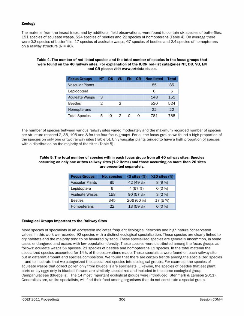
Zoology
The material from the insect traps, and by additional field observations, were found to contain six species of butterflies,
151 species of aculeate wasps, 524 species of beetles and 22 species of homopterans (Table 4). On average there
were 0.3 species of butterflies, 17 species of aculeate wasps, 67 species of beetles and 2.4 species of homopterans
on a railway structure (N = 40).
Table 4. The number of red-listed species and the total number of species in the focus groups that
were found on the 40 railway sites. For explanation of the IUCN red-list categories NT, DD, VU, EN
and CR please visit www.artdata.slu.se.
Focus Groups NT DD VU EN CR Non-listed Total
Vascular Plants 85 85
Lepidoptera 6 6
Aculeate Wasps 3 148 151
Beetles 2 2 520 524
Homopterans 22 22
Total Species 5 0 2 0 0 781 788
The number of species between various railway sites varied moderately and the maximum recorded number of species
per structure reached 2, 36, 106 and 8 for the four focus groups. For all the focus groups we found a high proportion of
the species on only one or two railway sites (Table 5). Only vascular plants tended to have a high proportion of species
with a distribution on the majority of the sites (Table 5).
Table 5. The total number of species within each focus group from all 40 railway sites. Species
occurring on only one or two railway sites (1-2 items) and those occurring on more than 20 sites
are presented separately.
Focus Groups No. species <3 sites (%) >20 sites (%)
Vascular Plants 85 42 (49 %) 8 (9 %)
Lepidoptera 6 4 (67 %) 0 (0 %)
Aculeate Wasps 158 90 (57 %) 3 (2 %)
Beetles 345 206 (60 %) 17 (5 %)
Homopterans 22 13 (59 %) 0 (0 %)
Ecological Groups Important to the Railway Sites
More species of specialists in an ecosystem indicates frequent ecological networks and high nature conservation
values. In this work we recorded 92 species with a distinct ecological specialization. These species are clearly linked to
dry habitats and the majority tend to be favoured by sand. These specialized species are generally uncommon, in some
cases endangered and occurs with low population density. These species were distributed among the focus groups as
follows: aculeate wasps 56 species, 21 species of beetles and homopterans 15 species. In the total material the
specialized species accounted for 14 % of the observations made. These specialists were found on each railway site
but in different amount and species composition. We found that there are certain trends among the specialized species
– and to illustrate that we categorized the specialized species into ecological groups. For example, the species of
aculeate wasps that collect pollen only from bluebells are specialists. Likewise, the species of beetles that eat plant
parts or lay eggs only in bluebell flowers are similarly specialized and included in the same ecological group –
Campanulaceae (bluebells). The 14 most important ecological groups were introduced (Stenmark & Larsson 2011).
Generalists are, unlike specialists, will find their food among organisms that do not constitute a special group.
Page 7
Vegetation Management for Road and Rail Corridors 307 ICOET 2011 Proceedings
Ecological Groups Controlled by the Sand Supply
The number of specialist species increases with the availability of
sand. The lower category of sand presence measured in the field
(low: <10% cover of sand on the site) yielded a lower number of
specialized species compared to the other categories (intermediate
and high) (ANOVA, F = 6.21, P = 0.005).
The Area of the Railway Sites
The area of the railway sites were on average 1,684 m2, it varied
between 410 and 9,020 m2. The area of the railway sites did not
differ between the different structure types (ANOVA, F = 0.49, P =
0.78), but the category of other structures tended to be larger and
even more varied. The area of the railway sites did not explain
species richness of butterflies, aculeate wasps, beetles or
homopterans, but an increasing area could be linked to an increased
quantity of substrate plants (correlations).
Abiotic Factors
The four different structure types tended to be statistically different with respect to the abiotic factors (ANOVA, F = 2.0,
P = 0.132). The categories of level crossings and bridges over roads included worse abiotic conditions compared to
other structures or bridges over water. The aculeate wasp fauna tended to be richer where the vegetation height was
lower on a railway site (regression, P <0.01). The beetle fauna tended to be represented by more species on the railway
site had more dense shrubbery (regression, P <0.01). The homopterans tended to be positively affected by the
availability of willows (regression, P <0.01).
DISCUSSION
The results indicate that the flora and fauna on the railway line sites are different from the typical railway flora and
fauna which is documented from the station areas. The sites along the lines house a surprisingly diverse and rich herb
and shrub flora, but are often small in area and the sites are often isolated from other grasslands. Unlike railway
stations, the sites along the lines include a great variety of biotopes.
The main conclusion from this work on grassland conservation along railway lines is that the natural value of an
individual grassland patch depends on both the near zone and landscape. The importance of the near zone a grassland
patch along a railway line occupies a small area (from 50 m2 to 1.5 ha). Therefore, these patches, if they are isolated
from other grasslands, have little opportunity to develop a habitat occupied by a wide range of grassland species. The
reason for this is that for most species do not reach the threshold of the substrate. As documented in this study, these
small sites have a higher tendency to develop a generalist fauna that is not dependent on any particular substrate. The
presence of specialized species and their respective ecological groups seem to be favoured by larger area of the patch
itself but also by a high grassland density in the surroundings.
The railway lines are visited by a great variety of insect species. During the survey we found more species of beetles,
compared with previous studies using the same method in railway stations (Larsson & Knöppel 2009). Studies on
roadside flora have shown that sites located in open areas (farmland, urban areas) have higher species numbers
compared with sites surrounded by forest (Tikka et al. 2000). But, contrary this, Runesson (2009) found that shady
areas along roadsides near forests generate more species of vascular plants. Probably species richness must be
broken down into smaller groups to be analysed as an effect of the surrounding neighbourhood. As an example, during
the survey in the present study, wood-nesting aculeate wasps tended to have higher species numbers at sites with
more shrubs. However, when analysing aculeate wasps that whole group there were no differences at all, because the
many species of ground nesting species wiped out the relationship.
Figure 4. A number of insects are
specialized on collecting pollen from
willows (Salix). These specialists are rarer
and are affected to a greater extent by
drastic changes in the landscape if
compared to generalist species.
Page 8
ICOET 2011 Proceedings 308 Session COM-4
Table 6. The four types of railway line structures and their history, present and potential value.
Structure History Present Value Future Value
Bridge over
water
Usually on sites where
herb- and shrublands
have long been
established.
Water creates an additional vale.
Slopes that increase diversity are
common. Managed by sporadic
cutting.
High. The water access is important. A
well planned management regime has
the capacity to increase the diversity in
all groups.
Bridge over
road
Limited number. Usually with large slopes. Creates a
base for dry meadow flora and
fauna. Managed by sporadic
cutting, often allows low shrubs.
High. The structure type increases in
number. Combination of road verge and
railway flora and fauna give
opportunities for co-planning.
Level
crossing
High diversity when
unpaved roads
dominated
Often lack slopes. Flower rich
thanks to road verge vegetation.
Managed by mowing and Roundup.
Low. Decreasing importance. Often
small areas. Difficult to come up with a
permanent vegetation management
plan due to small patches and
fluctuating needs.
Other
Structures
Often on sites
previously not
managed.
Small areas. Managed by mowing
or cutting.
Low. Small areas are difficult to use for
nature conservation purposes as
number of grassland species is low and
fluctuating.
Are railway sites objects of grassland species metapopulations or do they constitute an ecological trap? All grasslands
depend on the landscape at a regional level. The larger the grassland, the more self-sustaining, it can be. This means
that a broad and varied flora and fauna can be maintained despite little exchange with other populations. There are
many examples of large grasslands, which although they are separated from similar environments with hundreds of
kilometres still maintain a high biodiversity because there are a large variety of structures and substrates within the
grassland. However, this becomes increasingly difficult the less a grassland patch is. The grassland patches along
railway lines are in this context to be regarded as small or very small. It is therefore natural that most grassland is largely
a product of the surrounding landscape and we can talk about the following processes influencing the railway sites:
The exchange of individuals with surrounding grasslands (metapopulation)
One-way import of organisms from other grasslands (ecological trap)
The first process describes how small grassland patches can be part of a network of grasslands. Thanks to the network
of grasslands can be a number of species established in the area, even if individual grassland is not large enough to
house any species. This network of small populations is called a metapopulation (Fahrig 2003). The second process is
based on the existence of one or more major grassland area in the region that repeatedly colonizes the smaller site. In
the latter case one can consider the railway site a dead end: the site gets colonized by new plants and animals but
those vanish after one or two seasons because the conditions are missing. In this latter case is the railway grassland
patch diversity entirely dependent on the constant flow of individuals from surrounding habitats. This phenomenon is
called ecological traps (Battin 2004). In transport grasslands a possible additional ecological trap might be the
conditions created by the traffic. Trains and other vehicles constantly reduce insect populations by hitting individuals.
However, this effect is probably of minor importance – only a small proportion of species have a tendency to frequently
use the dangerous air space above the rails, over the asphalt or above the runway. When making decisions about
conservation efforts in these environments, it is necessary to sort out the degree to which the area is included in
metapopulations and in ecological traps.
The maintenance of grasslands along railway lines is complex due to the variety of ecological conditions. The four
structure types (bridge over water, bridge over roads, level crossings and other structures) differed significantly in terms
of conservation value (Table 6). In addition, two similar grassland patches can play completely different roles in the
landscape. One patch may not have exchange with other grasslands and, therefore, contain few grassland species, but
may instead be positive for biodiversity in other terms than grassland nature value, such as wetlands and forest. From
a nature conservation point of view, the work has to be done on both a local and a regional scale, both with the overall
goal to increase the biological grassland diversity. The local method of management of the railway line grasslands
should have the goal to develop standard vegetation management methods. The regional approach should take into
account the landscape surrounding the railway grassland sites. One way to work on a regional scale is to prioritize
different nature values and thereby focus on regions with high potential for nature values of dry grassland habitats.
Page 9
Vegetation Management for Road and Rail Corridors 309 ICOET 2011 Proceedings
ACKNOWLEDGEMENTS
The Swedish Transport Administration supported this study and gave helpful advices through field work and on earlier
versions of the manuscript.
BIOGRAPHICAL SKETCH
Magnus Stenmark defended his doctoral thesis in 2006 at Uppsala University. The thesis theme was on native bees
and on nature conservation methods using bees as indicators of valuable ecosystems. Since 2006 Magnus has been
working with practical conservation measures at a Swedish County Administration. Nature conservation information
and educational questions to farmers were the main tasks at a position in the Swedish Agriculture Board. Today,
Magnus has developed an own company providing expert issues in the field of nature conservation. The main
customers are national and regional governmental structures and companies in the area of wind power, power lines
and quarries.
REFERENCES
Allem, A.C. (1997). Roadside habitats: a missing link in the conservation agenda. The Environmentalist. 17:4-7.
Angold, P.G. et al (2006) Biodiversity in urban habitat patches. Science of the Total Environment 360: 196-204
Auestad, I., Rydgren, K., Jongejans, E & de Kroon, H. (2010). Pimpinella saxifraga is maintained in road verges by
mosaic management. Biological Conservation 143: 899–907.
Battin, J. (2004). When good animals love bad habitats: Ecological traps and the conservation of animal populations.
Conservation Biology 18:1482-1491.
Board of Agriculture (2010). Jordbruksmarkens användning [The use of farmland areas] 2010, JO 10 SM 1002.
Ekstam, U., Aronsson, M. & Forshed, N. (1988) Ängar. Stockholm: LTs förlag. Naturvårdsverket.
Fahrig, L. (2003). Effects of Habitat Fragmentation on Biodiversity. Annual Review of ecology, evolution, and
systematics. 34:1
Faunistica (2010). Unpublished database. 11-01-2010.
Gärdenfors, U. (red.) (2010). Rödlistade arter i Sverige 2010. [The 2010 Redlist of Swedish species.] ArtDatabanken,
SLU Uppsala.
Karlsson, T. (2008). Aculeate wasps i Östergötland – Inventeringar i sand- och grusmiljöer 2002-2007 samt övriga fynd
i Östergötlands län. Länsstyrelsen Östergötland, rapport 2008:9.
Larsson, M. & Knöppel, A. (2009). Biologisk mångfald på spåren. Zoologisk och botanisk inventering av järnvägsmiljöer
med fokus på hotade arter, skötsel och framtidsperspektiv. Banverket, Expert och utveckling, Borlänge.
Larsson, S. (2010). Spår till mångfald. Trafikverket, Borlänge. [A track to diversity. Swedish Transport Administration,
Borlänge].
Lennartson, T. & Gylje, S. (2009). Infrastrukturens biotoper – en refug för biologisk mångfald. CBM:s skriftserie 31
Noordijk, J., Delille, K., Schaffers, A.P., Sykora, K.V. (2009). Optimizing grassland management for flower-visiting insects
in roadside verges. Biological Conservation 142, 2097–2103.
Norderhaug, A., Ihse, M., Pedersen, O. (2000). Biotope patterns and abundance of meadow plant species in a
Norwegian rural landscape. Landscape Ecology 15, 201–218.
Runesson, K. (2009) Grassland plant species on road verges in Mid Sweden Influence of semi-natural grasslands and
impact of road maintenance. Examensarbete. Uppsala: Sveriges lantbruksuniversitet, Institutionen för ekologi.
Page 10
ICOET 2011 Proceedings 310 Session COM-4
Saure, C. (1996). Urban habitats for bees: the example of the city of Berlin. In: Matheson, A., Buchmann, S.L., O’Toole,
C., Westrich, P., Williams, I.H., eds. The Conservation of Bees. New York, Academic Press. pp. 47−54.
Stenmark, M. & Larsson, S. (2011). Gräsmarksytor längs järnvägar – med skötsel ett spår mot ökad mångfald.
Trafikverket, Borlänge. [Grassland patches along railway lines – a track towards increased biodiversity. Swedish
Transport Administration, Borlänge].
Spooner, P.G., Lunt, I.D., Briggs, S.V., Freudenberger, D., (2004). Effects of soil disturbance from roadworks on roadside
shrubs in a fragmented agricultural landscape. Biological Conservation 117, 393–406.
Tikka, P. M., Koski, P. S., Kivelä, R. A. & Kuitunen, M. T. (2000) Can grassland plant communities be preserved on road
and railway verges? Applied Vegetation Science 3: 25-32.
Page 11
Vegetation Management for Road and Rail Corridors 311 ICOET 2011 Proceedings
ASSEMBLAGE STRUCTURE OF PLANT COMMUNITIES ALONG THE ROAD CORRIDOR:
ROCK AND SCREE SLOPES – PLANTING VERSUS NATURAL RECOLONIZATION
Rosalyn Thompson (+353 (0) 21 421 1944, [email protected] )1,2
Lisa Dolan (+353 21 421 1944, [email protected] )1,2
Prof. Mark Emmerson (+44 (0)28 9097 2912, [email protected] )1,2,4*
Dr. Jens Dauber (+49 (0)531 596 2586, [email protected] )3,5*
Dr. Jane Stout (+353 (0)1 896 3761, [email protected] )3
Dr. David Bourke (Tel +353 (0)1 896 3746, [email protected] )3
Dr. Pádraig Whelan (Tel: + 353 (0)21 490 4560, [email protected] )1,2
1Environmental Research Institute, University College Cork, Cork, Ireland 2 School of Biological, Earth and Environmental Sciences, University College Cork, Cork, Ireland 3 School of Natural Sciences, Trinity College, Dublin 2, Ireland 4*Current address: School of Biological Sciences, Queen’s University, Belfast 5 *Current address: Institute of Biodiversity, Johann Heinrich von Thünen-Institute (vTI), 38116
Braunschweig, Germany
ABSTRACT
Road verges may perform an important function in the preservation of native floral diversity. This function may be
enhanced or diminished according to the landscape treatment which is chosen. Since 2006 a new guideline document
published by the National Roads Authority in Ireland has incorporated an ecological landscape design approach to such
landscaping. This includes a move away from horticultural practices to one which advocates a more sustainable
method. To test whether these guidelines were fulfilling their remit, sites were examined along a 300km primary route
in the south of Ireland. By comparing pre- and post-guideline sites an assessment was made whether stable plant
communities were developing and the nature of their species richness. There appeared to be little overall difference in
the outcome of the developing plant communities, whichever treatment was used. This has important implications in
terms of financial cost and the ultimate environmental sustainability of the landscape treatment used.
INTRODUCTION
The ecological impacts of road construction are well documented and include those visited upon the plant communities
which existed prior to the construction of the route corridor, along the ecotone or interface between the road corridor
and in the adjacent landscape (e.g. Spellerberg, 1998). Apart from the direct impacts on plant communities - i.e.
habitat loss and disturbance of soil systems through the construction of the road corridor - there are also indirect
impacts relating to the transportation and introduction of non-native invasive species. These may arrive through their
deliberate establishment through planting schemes or be accidentally introduced on construction-related and daily
traffic e.g. on tyres (Wace, 1977) and through wind dispersal (Wilcox, 1989). Native species may also have the
opportunity to flourish outside of their normal range e.g. halophytes growing inland, facilitated by the use of de-icing
agents (Scott and Davidson, 1982). Air-borne pollution from exhaust emissions can also alter growth or otherwise put
stress on plants (Angold, 1997).Maintenance activities of both the carriageway itself and of the vegetation immediately
adjacent to the carriageway can have significant impacts on adjacent plant communities (Lugo and Gucinski, 2000).
Ireland has recently undergone an extensive road building programme. Between 2002 and 2007 the national road
network increased substantially: under the Transport 21 programme, 1200km of roads are being developed to dual
carriageway or motorway standard (NRA, 2007; NDP, 2007). Much of this construction has crossed agricultural
landscapes which varied in intensity of management (NDP 2007, 2010). In Ireland, as elsewhere, agriculture is set to
continue along a path of intensification (Boyle, 2009). The potential exists for roads in more intensive agricultural
landscapes to provide not only a refuge for native flora (Perring, 1969), but also a means for the dispersal of certain
species (Tikka et al., 2001).
For the most part roads cut through soil slopes creating soil cuttings, and in undulating landscapes, soil embankments
are also constructed, which generally provide a basis for the establishment of grassland and woodland through planting
or natural recolonization. However, on occasions, roads also cut through gravels, scree and parent bedrock creating
rock-face cuttings or scree slopes. Published research concerning rocks and plant communities in Ireland tends to
centre around either designated conservation areas dominated by exposed bedrock with a high species-diversity i.e.
the Burren in the west of Ireland (e.g. Jeffrey, 2003) or rocky coastal habitats such as sea cliff faces (e.g. Cooper,
Page 12
ICOET 2011 Proceedings 312 Session COM-4
1997). Research elsewhere which examines such communities, post-human activity, concentrates on disused quarries
(e.g. Jefferson and Usher, 1989) or spoil from mining (e.g. Fitter and Bradshaw, 1974).
In 2006, Ireland’s National Roads Authority (NRA) published a guideline document on the landscaping of new national
road schemes (NRA, 2006). This ecological landscape design (ELD) approach (Dolan, 2004) provided a strategy to
redress some of the negative impacts of roads on flora and fauna and potentially improve connectivity in certain
intensively managed landscapes. It also advocated a move away from a high input regime stemming from an
agricultural/ horticultural approach (e.g. the creation of fertile conditions suitable for urban parkland style planting
schemes which can require a certain degree of management), to a regime that develops into self-sustaining habitats
which require minimum management. Previous planting schemes were not only costly to implement but have, in the
past, incorporated a significant proportion of non-native species (Dolan et al., 2009). The new guideline document
directed that the design incorporate and enhance existing native plant communities and also addresses arising issues
of fragmentation (Dolan, 2004). The opportunity now presents itself to examine the species richness of the establishing
plant communities which were established in line with the 2006 landscaping guidelines in comparison with roadside
landscapes which were landscaped prior to the introduction of the2006 landscaping guidelines.
For the purposes of this paper all sites created following these 2006 guidelines shall be deemed as being ‘post 2006-
guidelines’ and referred to as natural recolonization (NR) sites. Those sites landscaped in the pre-guidelines manner
are henceforth referred to as ‘planted’ (PL) sites. It should be borne in mind that PL sites, although planted do not
remain exclusively so and are also open to colonization by arriving propagules. In studying these sites an assessment
may be made as to whether the NR sites are creating the desired results.
METHODOLOGY
A 306 km east to west transect of the island of Ireland along the national road network - i.e. on the N25 and the N22
National Primary Route - was surveyed between the extremities of Rosslare, Co. Wexford (51º14’58.35 N, 6º20’36.92
W - in the east) and Tralee, Co. Kerry (52º15’51.46 N, 9º40’28.40 W - in the west). The sites were of a rock or scree
base and had a slope 1:2. Furthermore, sites with a southerly aspect were selected to eliminate the effects of aspect
on species richness.
16 paired sites were surveyed (Table 1). Each pair consisted of 1 x NR and 1 x PL site which were similar both in age
and geographical location so as to avoid temporal or spatial confounding effects (Figure 1).
The above-ground plant community was surveyed in May and June of 2009. At each site two 2m x 2m quadrats were
sampled 10m apart on the rock/scree faces within the centre of the face to avoid edge effects from the adjacent
habitat and away from the immediate road verge (located 1-3m from the pavement). A total of 64 quadrats were
surveyed, recording species on a visually estimated percentage cover basis. Slope, aspect and the presence of all
canopies were also recorded.
In 2010, the below-ground plant community was studied by gathering soil samples and undertaking a seed bank
analysis. This was done the following year in order to incorporate the seeds generated by the plants surveyed in 2009.
Soil was collected between April and June using a corer 6cm wide and to a depth of approximately 10cm. 12 cores
were taken at 1m intervals along a transect placed in the centre of the rock/scree face and parallel to the road
pavement. The transect centred on, and bisected, the original above-ground plant quadrats. For each site, the collected
soil was bulked together and brought back to the laboratory. The soil was then spread thinly (3 to 5mm deep) on beds
of vermiculite in half standard-size seed trays (154 x 205 x 52mm). These were placed outdoors and covered in
horticultural fleece to simulate natural environmental conditions. The fleece covering was employed to prevent seed
establishment in the trays from the surrounding environs. To prevent desiccation, the trays were kept watered and, as
seedlings emerged, they were identified, recorded and removed, or potted on until their identity could be established.
Species nomenclature follows Stace (2010); in addition, references to plant species in the Irish context use Webb et al.,
(1996) and Reynolds (2002).
Data analysis was undertaken using the R 2.8.1 (2008) statistical package. The Kolmogorov-Smirnov test was used to
establish the distribution of the data. Analysis was then undertaken with a paired t-test or Wilcoxon rank sum
distribution test. Sorensen’s Index (β-diversity) was used to calculate, firstly, the similarity of the two quadrats at each
site; and secondly, the similarity between PL and NR in site pairs 1 to 8. The species richness at NR sites as a function
of PL sites was also calculated to assess the relative performance within each pair. The rate of alien invasive species
richness was calculated as the number of alien invasive species recorded in the above-ground communities per
treatment divided by the number of sites in that treatment.
Page 13
Vegetation Management for Road and Rail Corridors 313 ICOET 2011 Proceedings
Table 1: Rock/Scree Site Details.
Pair County Lat/Long. Treatment
1 Wexford 52.38046 / 6.86523 PL
52.34809 / 6.61736 NR
2 Wexford 52.38061 / 6.86596 PL
52.3871 / 6.90742 NR
3 Kilkenny 52.3731 / 6.99737 PL
52.30503 / 7.05117 NR
4 Waterford 53.132865 / 7.074819 PL
52.24014 / 7.16460 NR
5 Waterford 52.06021 / 7.66716 PL
52.022869 / 7.393333 NR
6 Cork/Kerry 51.98078 / 9.26069 PL
51.90556 / 8.99386 NR
7 Kerry 51.98103 / 9.26275 PL
51.98774 / 9.2947 NR
8 Kerry 52.26798 / 9.42314 PL
52.12544 / 9.53441 NR
N.B. Some of these roadside landscapes were actually landscaped prior to the publication of the 2006 guidelines,
but following the ecological principles of the post 2006 guidelines. These have been included as NR.
Figure 1: Geographical location of the 8 pairs of sites along the N25 – N22 primary route.
RESULTS
Percentage Cover
The variation in mean percentage cover ranged from 42.5 to 131% in PL and 7.5% to 133% in NR sites (Figure 2).
Where the total exceeded 100%, this reflects complexity in the vegetation structure. The overall mean percentage cover
per treatment was: PL, 88%; NR, 85.5%. The overall median was: PL, 90.25%; NR, 105.75%. In five of the pairs, the
NR site had the higher mean per cent cover. In the three cases where PL had the greater mean cover, the difference
Page 14
ICOET 2011 Proceedings 314 Session COM-4
between the PL and NR was noteworthy in that it was greater than 35%. The greatest difference (pair 4) had an 82%
difference; pairs 1 and 7 had a 50% and 37.5% difference, respectively. Pair 3 had the largest difference where a NR
site had the highest per cent cover (67% greater).
Figure 2: the mean % cover of plants found at pre-2006 (PL) and post-2006 (NR) sites.
Species Data
Above-ground Plant Communities
93 species of higher plants and ferns were found in 64 plant quadrats on the rock/scree slopes in the roadside habitat:
34 present only in PL sites; 21 present only in NR sites; 35 common to both PL and NR sites. Of these: 87 were native,
4 were non-native, and 2 were undetermined beyond genus level. The non-native species were: Acer pseudoplatanus
(Sycamore), Aegopodium podagraria (Ground Elder), Cotoneaster sp., and Crocosmia x crocosmiiflora (Montbretia). A.
podagraria has been apparent in the Irish landscape since the mid-19th century and is widespread and frequent
(Reynolds, 2002). It is not currently seen as a threat in terms of displacement or degradation. The other three species
are classified as potential threats by Invasive Species Ireland - a joint British-Irish governmental initiative for the island
of Ireland (Invasive Species Ireland, 2011). The rate of non-native invasive species richness was 0.125 per m2 for PL
sites and 0.5 per m2 for NR.
Below-ground Plant Communities
When the seed bank data were added, an additional 17 species which did not appear in the above-ground plant
community were recorded. Of these: 4 were present only in PL sites; 11 species only in NR; 2 occurring in both. Four of
the additional species were non-native: Epilobium brunnescens, E. ciliatum, E. roseum, and Veronica persica. None of
the aforementioned appear on lists of species which are considered problematic, or potentially so.
Comparison of Above- and Below-ground Plant Communities
The commonest occurring species for both above and below-ground plant communities are listed in Table 2. Of these,
three grass species overlapped (Agrostis capillaris, Agrostis stolonifera and Holcus lanatus), and three forbs
overlapped (Geranium robertianum, Rubus fruticosus agg. and Ulex europaeus) by appearing in both above- and below-
ground communities. The Epilobium spp. were not identifiable at the time of the field surveys as the plants were
immature; however, two species (E. ciliatum and E. obscurum) germinated in many of the seed trays. All species listed
were common to both PL and NR sites with the exception of Holcus lanatus which only germinated in trays from PL
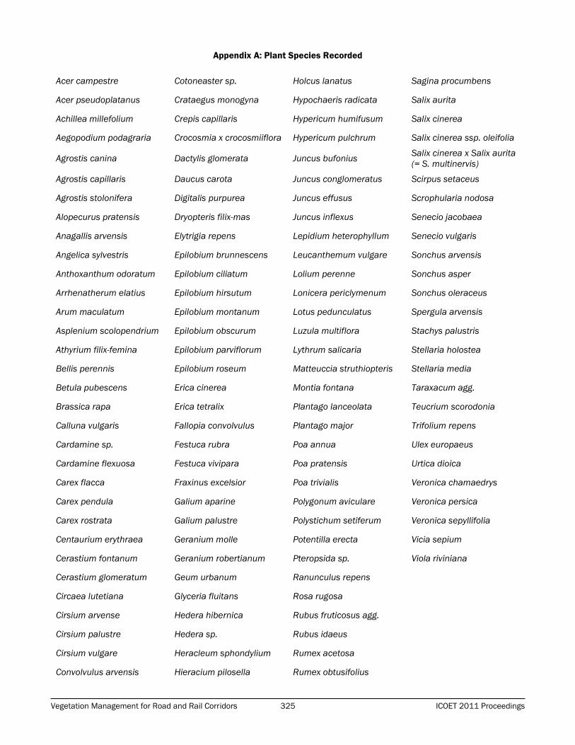
treatments. Full species list: Appendix A.
0
20
40
60
80
100
120
140
160
180
pair 1 pair 2 pair 3 pair 4 pair 5 pair 6 pair 7 pair 8
Sites
Mean
% C
over
Planted
NR
Page 15
Vegetation Management for Road and Rail Corridors 315 ICOET 2011 Proceedings
Table 2: Species Most Commonly Occurring in (a) Above-ground Communities or (b) Below-ground Communities.
(a) Above-ground plant species - recorded in at least 25% Quadrats (8)
Monocotyledons Qs PL NR Dicotyledons Qs PL NR
Agrostis capillaris 8 X X Epilobium sp* 8 X X
Agrostis stolonifera 8 X X Geranium robertianum 14 X X
Arrhenatherum elatius 12 X X Rubus fruticosus agg. 20 X X
Festuca rubra 9 X X Hedera sp. 9 X X
Holcus lanatus 10 X X Hypochaeris radicata 8 X X
Ulex europaeus 10 X X
(b) Below-ground plant species recorded in the seed banks of at least 25% Sites
Monocotyledons Sites PL NR Dicotyledons Sites PL NR
Agrostis capillaris 7 X X Cardamine flexuosa 6 X X
Agrostis stolonifera 5 X X Cerastium fontanum 4 X X
Anthoxanthum odoratum 4 X X Epilobium ciliatum 6 X X
Holcus lanatus 4 X Epilobium obscurum 5 X X
Juncus effusus 8 X X Geranium robertianum 7 X X
Leucanthemum vulgare 4 X X
Rubus fruticosus agg. 6 X X
Senecio jacobaea 4 X X
Ulex europaeus 5 X X
Plant Community Stability
A paired t-test was carried out for species richness of the quadrats at each site which revealed no significant difference at
any site (p-values ranged from 0.23 to 0.99). Sorensen’s Index for β-diversity was then applied and used as an indicator of
plant community stability: the greater the homogeneity, the greater the stability – where 0 is completely dissimilar and 1 is
identical. The most heterogeneous site was a PL site with a score of 0.29; the most homogenous one was an NR site with
a similarity index of 0.77. There was an overall pattern in terms of paired sites obtaining scores which ranked them
adjacently (i.e. pairs: 8, 6, 4, 2, 1.) Otherwise, a greater number of NR treatments (3) than PL (2) attained a score less
than 0.5 indicating a lower level of similarity between the quadrats at those sites. At the other end of the scale, nine of the
16 sites were more homogenous than heterogeneous (Sorenson β index > 5.) Five of these sites were NR sites (Table 3).
Table 3: Sorensen β-Diversity score for each site.
Pair Treatment Score
7 PL 0.286
3 NR 0.333
8 NR 0.375
8 PL 0.385
6 NR 0.4
6 PL 0.5
4 PL 0.5
4 NR 0.546
5 PL 0.571
7 NR 0.571
3 PL 0.593
5 NR 0.625
2 PL 0.632
2 NR 0.667
1 PL 0.696
1 NR 0.769
Page 16
ICOET 2011 Proceedings 316 Session COM-4
Species Richness
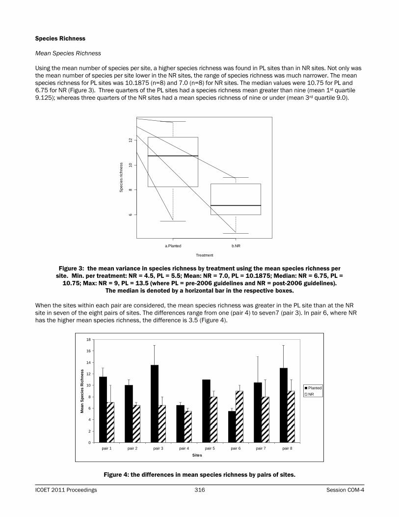
Mean Species Richness
Using the mean number of species per site, a higher species richness was found in PL sites than in NR sites. Not only was
the mean number of species per site lower in the NR sites, the range of species richness was much narrower. The mean
species richness for PL sites was 10.1875 (n=8) and 7.0 (n=8) for NR sites. The median values were 10.75 for PL and
6.75 for NR (Figure 3). Three quarters of the PL sites had a species richness mean greater than nine (mean 1st quartile
9.125); whereas three quarters of the NR sites had a mean species richness of nine or under (mean 3rd quartile 9.0).
Figure 3: the mean variance in species richness by treatment using the mean species richness per
site. Min. per treatment: NR = 4.5, PL = 5.5; Mean: NR = 7.0, PL = 10.1875; Median: NR = 6.75, PL =
10.75; Max: NR = 9, PL = 13.5 (where PL = pre-2006 guidelines and NR = post-2006 guidelines).
The median is denoted by a horizontal bar in the respective boxes.
When the sites within each pair are considered, the mean species richness was greater in the PL site than at the NR
site in seven of the eight pairs of sites. The differences range from one (pair 4) to seven7 (pair 3). In pair 6, where NR
has the higher mean species richness, the difference is 3.5 (Figure 4).
Figure 4: the differences in mean species richness by pairs of sites.
a.Planted b.NR
68
10
12
Treatment
Sp
ecie
s r
ich
ne
ss
0
2
4
6
8
10
12
14
16
18
pair 1 pair 2 pair 3 pair 4 pair 5 pair 6 pair 7 pair 8
Sites
Mean
Sp
ecie
s R
ich
ness
Planted
NR
Page 17
Vegetation Management for Road and Rail Corridors 317 ICOET 2011 Proceedings
Total Species Richness
When the total species richness at each site was calculated there was an overall increase in species richness of 26%
(for PL sites) and 38% (for NR sites) over the mean species richness values. However, there was considerable variation
between sites (Table 4). In some cases, the difference between the two treatments increased (such as in pairs 1 and
8); however, in pair 3 the difference between mean and total species richness was less marked.
Table 4: The Comparison of Mean and Total Species Richness by Site.
Pair Treatment Mean Total % increase
1 PL 11.5 15 30
NR 7 8 14
2 PL 10 13 30
NR 6.5 8 23
3 PL 13.5 19 41
NR 6.5 15 130
4 PL 6.5 9 39
NR 5.5 8 46
5 PL 10.5 15 43
NR 8.0 11 38
6 PL 5.5 9 64
NR 9 12 33
7 PL 10.5 18 71
NR 8 15 88
8 PL 13 21 62
NR 9 13 44
Comparison of Quadrat Data versus Quadrat and Seed Bank (S.B.) Data
The data for the seed bank analysis was included to assess the species richness of the below-ground plant community and
also analyse the overall change in species richness totals. Due to a storage problem with one soil sample, data from seven
pairs of sites were used and not eight. As the omitted pair’s sites (PL and NR) both had a below average mean species
richness (6.5 and 5.5 respectively), this resulted in a higher species richness for the seven remaining pairs (Table 5).
Table 5: The Differences in the Species Richness by Mean Treatment
using Quadrat (Q) only or Quadrat + S.B. Data.
PL NR
8 pairs Q data 14.63 11.25
7 pairs Q data 15.43 11.71
7 pairs Q data + S.B. 21.43 17.29
NR was also expressed as a function of PL within paired sites in terms of species richness (Table 6). In some pairs (for
example Pairs 1 and 7) there was relatively little change when the species richness of the below ground plant
community is included, whether mean species richness or total species richness is employed. In other cases, there was
a much greater change within each pair, so NR becomes more similar to PL, or alternatively more dissimilar. However,
the overriding feature of these results is that in all but two cases, the NR treatments result in lower species richness
than the PL treatments (whether mean species richness, total species richness or total species richness and below
ground seed bank species are included). The pairs where NR had greater species richness, this was not seen
consistently through all methods of calculation.
Page 18
ICOET 2011 Proceedings 318 Session COM-4
Table 6: The variation in species richness at each pair of sites using NR as a function of PL.
Data Used NR as a function of PL
Pair 1
Mean S.R. – Quadrats 0.61
Count S.R.– Quadrats 0.53
Count S.R .- Quadrats + seed bank 0.52
Pair 2
Mean S.R. – Quadrats 0.65
Count S.R.– Quadrats 0.62
Count S.R.- Quadrats + seed bank 0.73
Pair 3
Mean S.R. – Quadrats 0.48
Count S.R.– Quadrats 0.88
Count S.R.- Quadrats + seed bank 0.96
Pair 5
Mean S.R. – Quadrats 0.73
Count S.R.– Quadrats 0.73
Count S.R. - Quadrats + seed bank 1.06
Pair 6
Mean S.R. – Quadrats 1.64
Count S.R.– Quadrats 1.33
Count S.R .- Quadrats + seed bank 0.79
Pair 7
Mean S.R. – Quadrats 0.76
Count S.R.– Quadrats 0.83
Count S.R. - Quadrats + seed bank 0.76
Pair 8
Mean S.R. – Quadrats 0.69
Count S.R.– Quadrats 0.62
Count S.R. - Quadrats + seed bank 0.80
DISCUSSION
Percentage Cover
It might have been expected that the PL sites would have a greater percentage cover than the NR sites, due to the
planting of trees and shrubs post-construction of the scheme. Furthermore, PL sites are not isolated entities and, as
such, will be open to the same anemochory, zoochory (and even hydrochory) as NR sites. So it follows that, if the overall
mean percentage cover figures are used the planted sites have a marginally greater cover (88%), than the naturally
recolonized sites (85%). However, if the treatments are considered in pairs, then the picture is quite different as NR
sites have the highest mean cover in 5 of the 8 pairs. This would suggest that in terms of percentage cover, plants
which have naturally colonized the rock/scree faces have out-performed their PL counterparts (which are a combination
of planted species plus naturally colonized species). The two locations where this did not occur (pairs 4 and 7) may
have been the result of extreme environmental factors being exerted at the two NR sites: both were located in exposed
situations favouring colonization by stress-tolerant species, and neither had any complex vegetation adjacent. Stress-
tolerant species are frequently slow growers, which could account for the low percentage cover. The former (in pair 4),
had an ecotone boundary with intensively managed agricultural grassland. This was dominated by Lolium perenne
(Perennial Rye-grass) with Agrostis stolonifera (Creeping Bent) at the margin. L. perenne is typical of highly managed
grassland. Part of this high management is the necessity to reseed the species as it does not persist in grasslands –
having a short-lived seed bank and being poor at spreading vegetatively; furthermore it is most associated with level
ground or gentle slopes and water retentive (but not waterlogged) soils (Grime et al., 1988) A. stolonifera, on the other
hand successfully regenerates by seed or vegetatively and is a successful colonizer; however, it is better associated
with fertile habitats and is not stress tolerant (Grime et al., 1988). The two stress-tolerant species which were recorded
here, in the NR site of pair 4, were Hypochaeris radicata and Ulex europaeus (although young plants of the latter
species are not as stress tolerant) (Grime et al., 1988). Therefore, in addition to exposure, the adjacent highly
managed grassland may have had few species capable of withstanding the conditions. The latter NR site (in pair 7)
had an ecotone boundary with a semi-natural habitat which appeared to fall in to Fossitt’s (2000) Irish habitat category
Page 19
Vegetation Management for Road and Rail Corridors 319 ICOET 2011 Proceedings
HH3- wet heath. Molinia caerulea (Purple Moor-grass) and the species with which it is associated (Vaccinium myrtillus,
Calluna vulgaris, Erica tetralix and Erica cinerea which were all present in this habitat) lack ruderality as a trait (Grime
et al., 1988). Furthermore, the average soil depth generally found with this community is 15 to 50cm (Fossitt). On an
exposed slope over 45º in inclination (both PL and NR slopes had similar inclinations (≈ 45º) and orientation (PL =
170º, NR = 190º) soil may take some time to build up, hence slowing overall growth. Species that were found at the
NR site of pair 7which are tolerant of stress (usually infertile) conditions included: Agrostis canina, Calluna vulgaris,
Erica tetralix, Hypochaeris radicata, Hypericum pulchrum, Luzula multiflora and Ulex europaeus (Grime et al., 1988).
Plant Community Stability
A greater number of NR sites (five as opposed to four PL sites) were found to be homogenous (Sorenson similarity index
>0.5). This may be the result of the development of a more homogenous plant communities associated with arrival
and colonization of seed through anemochory (as opposed to zoochory); however the differences between the two sites
within each pair are relatively small – given the number of PL and NR sites from any one pair which are adjacent to
each other in Table 3. From a stability of plant community point of view, it could be argued that there is little overall
difference between the two treatments. Therefore in terms of sustainability, NR is preferred to PL in terms of: costs
incurred with PL (creating the soil base on a rock foundation, herbicides, fertilizers and the plants themselves); genetics
(of native and local species reproducing or otherwise hybridizing with imported plants), and biosecurity (inadvertent
importation of alien species which have arrived with foreign plant material or movements of soil).
Species
Overall, 14 more species were recorded in the PL quadrats (69 species) than in the NR ones (56 species). When the
seed bank data were added the difference narrowed to six species (PL = 75, NR = 69). None of those recorded have
protected status or are considered rare or threatened or listed as being less than ‘locally frequent’ according to Webb
et al., (1996) and Seawright (2010). Although 96% of the species found are ‘native’, many grass species are planted as
cultivars within the grass mixes planted on roadside landscapes; furthermore, such mixes are of non-local provenance.
The tree and shrub species, while they are not generally planted as cultivars, are of non-local provenance also; much of
the plant material originating from mainland Europe.
When the below-ground plant community data are added to the above-ground plant data, three interesting species
appear: all of them from the seed banks of NR sites. Firstly, Hypericum humifusum is described as an ‘occasional’
species (by Webb et al., 1996), appearing in peaty or sandy habitats. However, it may be more frequently found than
previously apparent as it has been listed as common on acidic heaths (Seawright, 2010). Secondly, Centaurium
erythraea was recorded in the soil seed bank from Macroom, Co. Cork (NR site, pair 6). Although not uncommon, it is
relatively rare inland (Webb et al., 1996): Macroom is some 35km from the coast. A similar case concerns Daucus
carota, which was recorded in the seed bank from a rock face in Co. Kilkenny: approximately 17km from the coast –
although less than 4km from a tidal river. This last-mentioned is found inland on limestone rock (Webb et al., 1996)
and the site had a pH of 7.17. However, it has also been commonly incorporated in to grass seed mixes utilized on road
schemes (Paul Green, County Recorder for the Botanical Society of the British Isles, pers. comm.). Although this was an
NR site, there were wide verges in the vicinity which had been sown with a standard grass seed mix.
In contrast, the following undesirable agricultural weeds (Teagasc, undated), which are relatively common species, were
recorded in either the above-ground communities or seed banks – Cirsium arvense (Creeping Thistle), Cirsium vulgare
(Spear Thistle), and Senecio jacobaea (Ragwort). These are notifiable weeds under the Noxious Weeds Act 1936
(Teagasc, undated). S. jacobaea was the only species to be recorded in all situations (i.e. in the above-ground plant
communities and seed banks of both PL and NR sites). Overall, there was no pattern to the presence of these species
in either below- or above-ground plant communities. It should be noted that while deemed undesirable to agriculture,
such species may fill a key ecological role in another species’ life-history. For example, S. jacobaea is the main
caterpillar foodplant for the Cinnabar moth Tyria jacobaeae (Butterfly Conservation).
Four non-native species were recorded: Acer pseudoplatanus (Sycamore), Aegopodium podagraria (Ground Elder),
Cotoneaster sp., and Crocosmia x crocosmiiflora (Montbretia). Three of the species recorded in the above-ground plant
communities occurred in the NR sites only: A. podagraria, Cotoneaster sp., and Crocosmia x crocosmiiflora. The latter
two species are of growing concern in Ireland and the U.K. and they have been included in an action plan under a joint
initiative between the National Parks and Wildlife Service (NPWS) in the Irish Republic and Northern Ireland
Environment Agency in the UK. (Invasive Species Ireland, 2011). In Ireland and in the U.K., Crocosmia x crocosmiiflora
spreads mostly vegetatively and only rarely by seed (NNSS, 2011). Therefore, measures which aim to avoid the
importation of soil and/or plant material and which monitor the movement of soil where Crocosmia x crocosmiiflora is
present within a route corridor should reduce opportunities for the invasion of roadsides by this species. Its presence is
Page 20
ICOET 2011 Proceedings 320 Session COM-4
therefore unexpected: did it exceptionally arrive by seed, or was there some other unaccounted for (human) activity
such as dumping of garden waste? Although both records were in rural settings, each had gardens within a few
hundred metres.
Cotoneaster, on the other hand, spreads through zoochory as the seeds are contained within red berries eaten by
garden birds. Its many garden ‘virtues’ and its apparent bonus to wildlife meant that it is extolled by professionals
connected with various sectors of the horticulture industry partly for its ability to colonise rocky surfaces with thin soil
covering. Ultimately, its spread may be more difficult to control as the species is capable of establishing in many
habitats including rough ground, banks and walls: particularly in areas where birds are able to perch (Stace, 2010).
The most recorded non-native species from the below ground plant community was Epilobium ciliatum (American Willow-
herb). Whilst not appearing on any known list for undesirable species, its seeds are dispersed by wind, it has naturalized
well in Europe, is the commonest willow-herb in much of lowland Britain, and, in Ireland, is spreading from urban areas,
particularly in the south of the country (Grime et al., 1988; Reynolds, 2002). It also hybridizes with native species such
as E. montanum and E. obscurum, both of which are amongst the commonest of all willow-herb hybrids (Stace, 2010).
Furthermore it occurs in sites with bare soil and high disturbance, and its seed can survive in the seed bank after the
above ground plants have been displaced by other species (Grime et al., 1988). The findings of this research will be
utilized to provide information on its current status in Ireland and may in turn inform treatment or management
strategies in general. From this research, it is apparent that this species has spread across southern Ireland – it having
germinated from seed banks in the road corridor along the entire 300km of road surveyed as part of this study.
Species Richness
With reference to treatment, PL had a higher species richness (mean: 31% higher, median: 37% higher) than NR. The
higher species richness in PL sites may be attributed to the fact that trees, shrubs and grasses were planted, together
with ground preparation (such as the introduction of soil or hydroseeding), use of herbicides and fertilizers involved with
the landscaping, This introduced a higher amount of plant material which was then in turn able to exploit the higher
availability of resources than would otherwise be available on bare rock or scree. However, the greater species richness
at PL sites also means an introduction of cultivars, as opposed to Irish provenance material; this may be to the
detriment of the local gene pool. The further development of these rock face communities will make an interesting
study in the future to determine any reduction in the difference in species richness between the treatments.
Furthermore, is the higher species richness at PL sites at the cost of being appropriate to its location? A sense of place
needs to be considered with landscape schemes. Just because a species is native to Ireland would not automatically
result in there being a source for its propagules in the vicinity of a newly-landscaped rock face or slope. By using
standard seed mixes or planting schemes, species may establish which are untypical of the wider countryside thus
creating a feature which does not blend with its surroundings. Slower to develop NR sites may need time to close the
gap, yet ultimately appear more in character with the wider landscape. Moreover, the presence of fewer competitive
grasses might leave room for a greater number of forbs and less competitive monocotyledons.
Amongst the lowest recorded species richness at sites in either treatment were those belonging to pair 4. In this pair,
both sites (PL and NR) were located on the ring road that circles Waterford city with landscape treatments dating from
2006. They are both almost equal in terms of species richness. This may be due to both the PL and NR sites being
adjacent to highly managed grassland – so that there are fewer species in the adjacent field to act as a potential
source of propagules.
There was only one pair of sites where the NR species richness exceeded that of the PL site, namely in pair 6. Here,
both sites were among the older pairs in terms of length of time since their creation. However, the key difference may
have been the proximity of mature and complex vegetation.
Total Species Richness and Seed Bank
The overall trend in species richness is similar whether mean, total or total + seed bank is used. That is, the PL sites
have a higher species richness than NR sites. However, certain differences do occur within the results depending on
the data included. Taking NR as a function of PL, Pairs 1 and 6 have a declining trend when mean (pair 1 = 0.62; pair
6 = 1.64), total (pair 1 = 0.53; pair 6 = 1.33), and above and below ground plant communities (pair 1 = 0.52; pair 6 =
0.79) are considered in that order. Pair 3, on the other hand indicates that NR is approaching PL, particularly when the
total species or total + seed bank values are used. The increase in pairs 5 and 8 is most noticeable between total
species counts and the addition of the seed bank data. In pair 5 this is particularly noteworthy as the NR site
‘outperforms’ the PL site.
Page 21
Vegetation Management for Road and Rail Corridors 321 ICOET 2011 Proceedings
The method employed for data collection can have a bearing on the results. The inclusion of the seed bank meant that
the overall species numbers increased and included the less common species. The numbers of recorded species in this
study might have been even higher had greenhouse or laboratory conditions been employed. However, one of the aims
of the investigation was to reproduce near natural conditions, to see what might have germinated under natural
conditions. Analysis is still ongoing, including that which includes a second visit to each site carried out in the second
half of the summer of 2009. Although such an approach means a significant investment in time and money, it will be
interesting to examine this fuller picture and assess what is lost if one or more of these elements is not undertaken.
It is not clear why the species in the below ground community were not present in the above ground community. It is
possible that they have been there since road construction and never had the stimulus to germinate. It is also possible
that they may never have germinated unless the soil in which they were located experienced disturbance – such as the
act of removing the soil cores for the seed bank trial. Many seeds can survive underground for years. In the case of PL
sites, it is clear that there are several possibilities for non-planted species to establish – e.g. by “piggybacking” on those
species which are to be planted; arriving by anemochory or zoochory and their subsequently becoming buried. However,
it is harder to account for the seed bank at the NR sites. Build-up of litter and soil may be one possibility with trapped
seeds waiting for the appropriate stimulus to germinate.
Preliminary Conclusions
1) Overall, the stability of the plant community at a site seems to be either no different, or slightly greater, in NR
sites than in the case of PL sites. If this is the case, then this suggests that the costs involved in P treatments
may be avoided without compromising the outcome. Of course, the desirability of the species which colonize
the habitats needs to be examined and further study is ongoing as to the relationship of non-desirable species,
such as (alien) invasive species and varying treatments.
2) In terms of percentage cover of species, the picture was quite mixed and may be dependent on a number of
environmental factors as well as the availability of propagules and the vicinity of complex vegetation structure.
3) Species richness overall was higher in PL sites. However, this is to be expected given that the PL treatment
involves importing plant material to the site, in addition to those species which would colonize naturally from
the surrounding area.
4) If NR and PL are producing almost the same results, then NR should be the treatment adopted as it is more
sustainable than PL.
5) Method of data collection may have a bearing on results: the soil seed bank added important data to the
quadrat data.
ACKNOWLEDGEMENTS
This research is funded by the project SIMBIOSYS (2007-B-CD-1-S1) as part of the Science, Technology, Research and
Innovation for the Environment (STRIVE) Programme, financed by the Irish Government under the National
Development Plan 2007–2013, administered on behalf of the Department of the Environment, Heritage and Local
Government by the Irish Environmental Protection Agency (EPA).
I am also grateful for the advice, direction and support of my supervisors Dr Pádraig Whelan (University College Cork)
and Professor Mark Emmerson (Queen’s University Belfast) and researcher Lisa Dolan. Thanks are also extended to
Paul Green (county recorder for Botanical Society of the British Isles) and Máiread Kiely (senior technical officer,
University College Cork).
BIOGRAPHICAL SKETCHES
Rosalyn Thompson is currently a PhD student at University College Cork (UCC). Part of the national EPA-sponsored
SIMBIOSYS project which is investigating sectoral impacts on biodiversity and ecosystem services, including quantifying
impacts of energy crops, road landscaping and aquaculture on Irish ecosystems – set up in 2008 - her focus is on
invasive plant species and invasion resistance. Originally from Caerleon, South Wales (UK), she graduated from Bath
Spa University with an honours degree in Environmental Science in 2008.
Lisa Dolan is a landscape ecologist whose work to date has focussed on road ecosystems and their impacts on
biodiversity and ecosystem services in the agri-environment. Lisa is currently a research assistant in University College
Cork (UCC). She is a member of the national EPA-sponsored SIMBIOSYS project, set up in 2008, which is investigating
sectoral impacts on biodiversity and ecosystem services, including quantifying impacts of energy crops, road
landscaping and aquaculture on Irish ecosystems
Page 22
ICOET 2011 Proceedings 322 Session COM-4
Prof. Mark Emmerson graduated from Queen Mary University of London, UK in 1995 with a BSc (Hons) in Marine and
Freshwater Biology. He then moved to the University of Aberdeen in Scotland where he undertook both an MSc in
Marine and Fisheries Science (1996-1997) and a PhD in Zoology (1997-2001). His PhD was focussed on combining
empirical and theoretical approaches to the study of Biodiversity and Ecosystem Functioning. He then moved to the
University of York where he undertook a Post doc focussed on the role of body size in food webs (2001-2003). He was
appointed as a College Lecturer at University College Cork in the Republic of Ireland in 2003. In 2010, he joined the
School of Biological Sciences at Queens as Chair of Biodiversity. Professor Emmerson's research combines theoretical
and empirical approaches in the study of ecological systems. He is the leader of the SIMBIOSYS workpackage
investigating the impacts of energy crops on biodiversity and ecosystem functioning.
Dr Jens Dauber is a landscape ecologist, working at the Federal Research Institute for Rural Areas, Forestry and
Fisheries, Germany (vTI). His main research interest is on the impact of land-use change and climate change on
biodiversity in agricultural landscapes. He studied Biology at the University of Mainz, Germany, and finished with a
Diploma in Biology in 1995. In 1996, he went to the University of Giessen, Germany, to do a PhD on the effects of land-
use change on ant communities within the framework of the project "Land-use Options for Peripheral Regions" (SFB
299). He continued working in Giessen as post-doctoral research fellow in the project "BIOPLEX – Biodiversity and
Landscape Complexity in Agricultural Areas under Global Change", acting as leader of the Landscape Ecology group
within the Department of Animal Ecology. In 2003, he visited the SLU Uppsala, Sweden, for three month to study ant
communities in fragmented semi-natural grasslands. End of 2006 he moved to the University of Leeds, UK, to work as
research fellow in the EU FP6 project ALARM. In May 2008 he took up the position of project manager of SIMBIOSYS at
Trinity College Dublin, Ireland. He is on the editorial board of BioRisk – Biodiversity and Ecosystem Risk Assessment
and handling editor of Biodiversity and Conservation.
Dr Jane Stout is a Senior Lecturer in the School of Natural Sciences. Jane did her BSc in Environmental Sciences
(1995) and PhD in Ecology (1999) both at the University of Southampton, UK. Her PhD investigated the foraging
ecology of bumblebees, focusing on intrinsic and extrinsic influences on behaviour, and how behaviour influenced plant
reproductive success.
Dr Stout went to Trinity College Dublin as an Enterprise Ireland Post-doctoral Fellow in 2001 to research the role of
native pollinators in the spread of invasive plants, and was appointed a Broad Curriculum Lecturer in 2003 and
Lecturer in Botany in 2007 at TCD. Dr Stout continues to use plant-pollinator interactions as a model system, and her
research focuses on investigating anthropogenic impacts on biodiversity and the delivery of ecosystem services. She is
the co-ordinator of the national EPA-sponsored SIMBIOSYS project which is investigating sectoral impacts on
biodiversity and ecosystem services, including quantifying impacts of energy crops, road landscaping and aquaculture
on Irish ecosystems.
Dr David Bourke is currently a Research Fellow in the School of Natural Sciences, Trinity College Dublin, Ireland.
Previously he held a position of postdoctoral researcher jointly hosted by the Applied Ecology Unit in the Centre for
Environmental Science and the Department of Botany at the National University of Ireland – Galway. His current
research interests are focused on the indirect impacts of climate change mitigation measures such as bioenergy crops
and wind farm developments on biodiversity and ecosystem services. He is also working on the direct impacts of
climate change on biodiversity, specifically on current and future distributions of species and habitats of conservation
value. Dr Bourke gained his PhD from the Department of Botany, Trinity College Dublin working on phosphorus
dynamics in grazed grassland ecosystems. Previously, as a research officer with Teagasc (Agriculture and Food
Development Authority in Ireland), he worked on evaluating the environmental effectiveness of agri-environmental
schemes across Europe. He is the current project manager of SIMBIOSYS.
Dr Pádraig Whelan is a lecturer in the School of Biological, Earth and Environmental Sciences in University College
Cork, Ireland, since 1995. He is the leader of a workpackage on the impacts of roads on biodiversity within the national
EPA-sponsored SIMBIOSYS project, set up in 2008, which is investigating sectoral impacts on biodiversity and
ecosystem services, including quantifying impacts of energy crops, road landscaping and aquaculture on Irish
ecosystems. His BSc (1976) and PhD (1986) are from University College Cork. His interests lie in applied biodiversity
conservation in protected areas and in the wider landscape, as well as the biology and management of invasive alien
species. He has carried out research in South America and Europe.
Page 23
Vegetation Management for Road and Rail Corridors 323 ICOET 2011 Proceedings
REFERENCES
Angold, Penny G. "The Impact of a Road Upon Adjacent Heathland Vegetation: Effects on Plant Species Composition."
Journal of Applied Ecology 34 (1997): 409-417.
Boyle, Gerry. “The Irish Agricultural Rural Landscape.” Proceedings from The Irish National Landscape Conference.
Tullamore, Co. Offaly. 14-16 October, 2009. Kilkenny: The Heritage Council, Ireland.
Butterfly Conservation “The A-Z of Day-flying Moths” Last modified: 11 Jun 2011. (Accessed 30 June 2011)
Cooper, Alan. "Plant Species Coexistence in Cliff Habitats." Journal of Biogeography 24 (1997): 483-494.
Dolan, Lisa M.J. 2004. “Roads as Ecosystems: A More Sustainable Approach to the Design of Irish Rural Roadside
Verges.” In John Davenport and Julia L. Davenport (eds.) The Effects of Human Transport on Ecosystems: Cars and
Planes, Boats and Trains. 15-62. Dublin: Royal Irish Academy.
Dolan, Lisa M.J. Pádraig Whelan, Mark Emmerson. “Road Infrastructure and the Landscape.” Proceedings from The
Irish National Landscape Conference. Tullamore, Co. Offaly. 14-16 October, 2009. Kilkenny: The Heritage Council,
Ireland.
Fitter, Alastair H. and Anthony D. Bradshaw. "Root Penetration of Lolium perenne on Colliery Shale in Response to
Reclamation Treatments." Journal of Applied Ecology 11(1974): 609-615.
Fossitt, Julie. A Guide to Habitats in Ireland. (Reprinted edn. 2007). Kilkenny: The Heritage Council, Ireland.
Grime, J. Philip. John G. Hodgson, Roderick Hunt. Comparative Plant Ecology: A functional approach to common British
species. London: Unwin Hyman (1988).
Invasive Species Ireland. (A joint initiative by Northern Ireland Environment Agency & National Parks and Wildlife
Service, Ireland) “Most Unwanted Species.” Last modified: 21 June 2011.
http://invasivespeciesireland.com/toolkit/risk-assessment/amber-list-established-species/
Jefferson, R. G. and M. B. Usher. "Seed rain dynamics in disused chalk quarries in the Yorkshire Wolds, England, with
special reference to nature conservation." Biological Conservation 47(1989): 123-136.
Jeffrey, David. W. "Grasslands and Heath: A Review and Hypothesis to Explain the Distribution of Burren Plant
Communities." Biology and Environment: Proceedings of the Royal Irish Academy 103B (2003): 111-123.
Lugo, Ariel. E. and Hermann Gucinski. "Function, effects, and management of forest roads." Forest Ecology and
Management. 133 (2000): 249-262
NDP (National Development Plan). “National Development Plan 2007-2013 - Transforming Ireland.” 2007. Dublin: The
Stationery Office.
NDP. Transport 21. National Roads Network 2015. Last modified: 11 May 2010. Accessed: 30 June 2011.
http://www.transport21.ie/Maps/Transport_21_Maps/Navigation.html
NNSS. (GB Non Native Species Secretariat) 2011. GB Non-native Species Information Portal. Accessed 30 June 2011.
https://secure.fera.defra.gov.uk/nonnativespecies/factsheet/index.cfm
NRA (National Roads Authority). 2006. A Guide to Landscape Treatments for National Road Schemes in Ireland. NRA,
Ireland.
NRA. “New Divided Road Types: Type 2 and Type 3 Dual-carriageways.” 2007. Accessed: 30 June 2011.
http://www.nra.ie/Publications/DownloadableDocumentation/RoadDesignConstruction/file,11236,en.pdf..Dublin:
NRA
NRA “National Roads Network 2015.” Last updated 11 May 2010. Accessed: 30 Jun 2011.
http://www.transport21.ie/Maps/Transport_21_Maps/National_Roads_Network_2015.html
Page 24
ICOET 2011 Proceedings 324 Session COM-4
OpenStreetMap. 2011. Open data site created under Creative Commons Attribution-ShareAlike 2.0 licence. Accessed:
30 June 2011. www.openstreetmap.org and to www.creativecommons.org.
Parr, T. W. and J. M. Way. "Management of Roadside Vegetation: The Long-Term Effects of Cutting." Journal of Applied
Ecology 25 (1988): 1073-1087.
Perring, F.H. “The botanical importance of roadside verges.” In: Way, J.M., (ed.) Road verges - their function and
management. 4-7. Abbots Ripton: The Nature Conservancy (1969). Available at http://nora.nerc.ac.uk/7112/
R Development Core Team. 2008. R: A language and environment for statistical computing. R Foundation for Statistical
Computing, Vienna, Austria. ISBN 3-900051-07-0, URL http://www.R-project.org.
Reynolds, Sylvia C. P. 2002. A catalogue of alien plants in Ireland. Occasional papers No.14, National Botanic Gardens,
Glasnevin.
Scott, Nicholas E. and A.W. Davison. “De-icing salt and the invasion of road verges by maritime plants.” Watsonia 14
(1982): 41-52.
Seawright, Jenny. 2010. Irish Wildflowers. A database. Accessed: 30 Jun 2011. http://www.irishwildflowers.ie/
Spellerberg, Ian F. “Ecological Effects of Roads and Traffic: a literature review.” Global Ecology and Biogeography
Letters. 7 (1998): 317 – 333.
Stace, Clive. 2010. New Flora of the British Isles 3rd edn. Cambridge University Press, Cambridge.
Teagasc (Agriculture and Food Development Authority, Ireland) “Fact Sheet: Noxious Weeds.” Undated. Accessed: 30
June 2011. http://www.teagasc.ie/horticulture/advisory/vegetable/noxious-weeds.asp
Tikka, Päivi M. Harri Hogmander, Piia S. Koski . "Road and railway verges serve as dispersal corridors for grassland
plants." Landscape Ecology 16 (2001): 659-666.
Wace, Nigel. “Assessment of dispersal of plant species - the car-borne flora in Canberra.” Proc. Ecol. Soc. Austr. 10:
(1977) 167-186.
Webb. David. Parnell, J. Doogue, D. 1996. An Irish Flora. 7th edn. Dundalgan Press, Dundalk.
Wilcox, Douglas A.“Migration and control of purple loosestrife (Lythrum salicaria L.) along highway corridors.”
Environmental Management 13 (1989): 365-370.
Page 25
Vegetation Management for Road and Rail Corridors 325 ICOET 2011 Proceedings
Appendix A: Plant Species Recorded
Acer campestre Cotoneaster sp. Holcus lanatus Sagina procumbens
Acer pseudoplatanus Crataegus monogyna Hypochaeris radicata Salix aurita
Achillea millefolium Crepis capillaris Hypericum humifusum Salix cinerea
Aegopodium podagraria Crocosmia x crocosmiiflora Hypericum pulchrum Salix cinerea ssp. oleifolia
Agrostis canina Dactylis glomerata Juncus bufonius Salix cinerea x Salix aurita
(= S. multinervis)
Agrostis capillaris Daucus carota Juncus conglomeratus Scirpus setaceus
Agrostis stolonifera Digitalis purpurea Juncus effusus Scrophularia nodosa
Alopecurus pratensis Dryopteris filix-mas Juncus inflexus Senecio jacobaea
Anagallis arvensis Elytrigia repens Lepidium heterophyllum Senecio vulgaris
Angelica sylvestris Epilobium brunnescens Leucanthemum vulgare Sonchus arvensis
Anthoxanthum odoratum Epilobium ciliatum Lolium perenne Sonchus asper
Arrhenatherum elatius Epilobium hirsutum Lonicera periclymenum Sonchus oleraceus
Arum maculatum Epilobium montanum Lotus pedunculatus Spergula arvensis
Asplenium scolopendrium Epilobium obscurum Luzula multiflora Stachys palustris
Athyrium filix-femina Epilobium parviflorum Lythrum salicaria Stellaria holostea
Bellis perennis Epilobium roseum Matteuccia struthiopteris Stellaria media
Betula pubescens Erica cinerea Montia fontana Taraxacum agg.
Brassica rapa Erica tetralix Plantago lanceolata Teucrium scorodonia
Calluna vulgaris Fallopia convolvulus Plantago major Trifolium repens
Cardamine sp. Festuca rubra Poa annua Ulex europaeus
Cardamine flexuosa Festuca vivipara Poa pratensis Urtica dioica
Carex flacca Fraxinus excelsior Poa trivialis Veronica chamaedrys
Carex pendula Galium aparine Polygonum aviculare Veronica persica
Carex rostrata Galium palustre Polystichum setiferum Veronica sepyllifolia
Centaurium erythraea Geranium molle Potentilla erecta Vicia sepium
Cerastium fontanum Geranium robertianum Pteropsida sp. Viola riviniana
Cerastium glomeratum Geum urbanum Ranunculus repens
Circaea lutetiana Glyceria fluitans Rosa rugosa
Cirsium arvense Hedera hibernica Rubus fruticosus agg.
Cirsium palustre Hedera sp. Rubus idaeus
Cirsium vulgare Heracleum sphondylium Rumex acetosa
Convolvulus arvensis Hieracium pilosella Rumex obtusifolius
Page 26
ICOET 2011 Proceedings 326 Session COM-4
ECOLOGICAL RESTORATION OF TRANSPORTATION PROJECTS AS A
SUCCESSFUL MITIGATION MEASURE
Sergio López Noriega (52 (55) 55 56 87 27 00, [email protected] ), Biologist, CEO, Grupo
Selome S.A. de C.V., Louisiana 104 Col. Nápoles 03810 Mexico
Norma Fernández Buces, PhD Science (52 (55) 55 56 87 27 00, [email protected] ), Scientific
Director, Grupo Selome S.A. de C.V., Louisiana 104 Col. Nápoles 03810 Mexico
ABSTRACT
One of the most important environmental impacts caused by roads is the loss of vegetation cover within the right of way
and hillsides. This impact can be successfully restored as long as appropriate timely actions are considered. The area
to be affected should be carefully studied, previous to the construction of the road, in order to identify types of nearby
vegetation and their characteristics. An ecologically based restoration program should be developed, in which all
actions required are pointed out and adequately planned.
Species composition, community structure, tolerances and endangered or protected species should be identified. This
information will be used to build a plant nursery where native species are to be reproduced and grown before their use
in restoring the landscape, jointly with the organic soil removed during construction. These actions need to be
performed under a specific scheme of planting that will allow the reconstruction of a landscape, similar to the affected
one in its original stages.
A successful example of such actions could be the Ecological Restoration held on to mitigate environmental impact of
the Mexico-Tuxpan highway, in the Tejocotal-Nuevo Necaxa section. In this road, built about 6 years ago, an Ecological
Restoration of the original community of cloud forest was done in 2006, following an innovative plantation design and
using native species integrated by endangered rescued plants, as well as seed produced and cuttings from nearby
plants, grown in a nursery specifically build for this project. This type of forest is scarce in our country; therefore, its
restoration and conservation are very important issues.
Another example of a successful ecological restoration program concerning transportation is the construction of the
Cuyutlan lagoon railroad in Manzanillo, where a full study of vegetation preceded seed and plant recovery, a nursery to
keep rescued plants and produce new ones up to about 120,000 plants needed to fulfill the restoration program
requirements. Soil conservation played an important role in this program as piles of rescued organic soil (from railroad
construction) were mixed with crushed residues from vegetation clearing and organic garbage from the workers lunch
room. Soil was preserved for several months under humid conditions to enable composting and was eventually turned
over for better compost formation.
Ecological restoration of a transportation project as a mitigation measure has great advantages, not only in the
environmental matters, but also in construction costs. It reduces expenses on conservation and maintenance of
vegetation as plants are appropriate for local climate-soil conditions. For these measures to be efficient and effective,
they need to be developed under a planned scheme, an opportune Ecological Restoration Program.
INTRODUCTION
All infrastructure projects in Mexico are required to apply for and obtain an environmental impact authorization. This is
obtained through an Environmental Impact Statement (EIS); which deals with environment fragility, project impacts
during construction and operation, and the proposal of several mitigation measures. Among this mitigation measures,
ecological restoration programs are required by the environmental authorities to be applied at specific sites affected by
transportation projects.
Compliance with mitigation measures and regulation policies is crucial for a project to be successful within a framework
of environmental conservation and social benefit. The adequate execution of restoration programs is important for the
recovery of landscape connectivity and habitat fragmentation, ecosystem properties lost by the construction of a
transportation project.
In this work we present the results of two ecological restoration programs, applied for the mitigation of environmental
impact caused on natural vegetation during the construction of two transportation projects: a highway and a railway in
Mexico. Both case studies were successful restoration experiences related to infrastructure projects. They represent
two different approaches as the first case, Nuevo Necaxa, was done within a government environmental protection
Page 27
Vegetation Management for Road and Rail Corridors 327 ICOET 2011 Proceedings
area (ANP), and therefore it required a detailed long term restoration program; whereas the Cuyutlán restoration
program had to be done in a fast and efficient way to cope with time requirements.
STUDY SITES AND BACKGROUND
a) Mexico-Tuxpan highway. A 18 km zone in the Tejocotal-Nuevo Necaxa section (Figure 2a)
An 17.5 km long section of the Mexico-Tuxpan highway, from Tejocotal dam to Nuevo Necaxa (state of Puebla) was built
in 2006 within mountain landscape on a temperate weather, where a cloud forest grows at such high altitude (2,070
and 2,138 masl).
Cloud forest (Figure 1) is scarce in Mexico and it includes several plant species protected by law. This vegetation is
sparsely distributed in the area, as it has been removed by locals for wood and cattle introduction. Habitat loss in the
Tejocotal-Nuevo Necaxa region has been a very serious problem for the last decade, and the construction of this
highway implied removing some patches of remaining cloud forest vegetation along a 6 km section, crossing through
the buffer zone of an environmentally protected area; therefore, as part of the EIA resolution, environmental authorities
required the development of an Ecological Restoration Program of cloud forest vegetation within the right of way and
surrounding area of the highway along those 17.5 km. This program had to consider the rescue of endangered and
ecologically important species and the restoration of cloud forest vegetation in all sites affected by the construction and
inside the highway right of way and its immediate surroundings. An Ecological Restoration program was defined in
2004 and by 2006, when construction ended, restoration actions were applied along the right of way of this highway
and proximities.
Figure 1. Cloud Forest at the Tejocotal-Nuevo Necaxa region in Puebla, Mexico.
b) Cuyutlan lagoon railroad in Manzanillo (Figure 2b).
This railroad runs along the northern coast of the Cuyutlan coastal lagoon, at the southeastern portion of Manzanillo,
state of Colima. It implies a new route and modernization of actual railroad, which needs to be removed in order to
widen the lagoon channel into the ocean, allowing the entrance of tanker ships that will deliver natural gas into a gas
terminal destined to supply the Manzanillo power plant. With this change in fuel supply, the power plant will operate
under more ecological conditions, but the new railroad needs to be operant before the lagoon channel can be widen.
This railroad is very important for the import and export of products on the western coast of Mexico, through the port of
Manzanillo. It is being built on overpasses along the northern margin of the Cuyutlan lagoon, involving both terrestrial
and aquatic ecosystems. It crosses through 2.82 ha of well-preserved tropical deciduous forest on the east margin of
the lagoon, as well as 0.47 ha of mangrove. All of the four mangrove species reported for Mexico and several cactuses
within the tropical deciduous forest are protected by law; therefore, all mitigation measures, especially those regarding
mangrove and tropical deciduous forest protection, conservation and restoration were very important and should be
included in an Ecological Restoration Program.
Page 28
ICOET 2011 Proceedings 328 Session COM-4
a b
Figure 2. a) Nuevo Necaxa – Tihuatlan highway, section where ecological restoration of cloud
forest vegetation was done. b) Cuyutlan lagoon railroad and the 4 km section where ecological
restoration program for tropical deciduous forest vegetation was applied.
OBJECTIVE
With these two case studies we want to present the results of well-planned and efficient ecological restoration actions
on damaged sites, based on an Ecological Restoration Program. Both programs were developed in coordination with
the environmental authorities and the construction company, and considered the ecological properties of nearby
vegetation communities in search of reducing fragmentation, habitat loss and increasing connectivity among remaining
vegetation patches.
METHOD
a) Mexico-Tuxpan highway. Tejocotal-Nuevo Necaxa section
Complementary to the EIA study, vegetation communities along the highway right of way were analyzed and species
composition, community structure and degree of human disturbance defined in 20 sampled sites. Herbs, bushes and
trees were sampled using concentric circle method (Merino–Pérez et. al. 2001; Ruiz–Jiménez et. al. 2001). The 17.5
km long section was divided in a GIS in 12 restoration zones, according to the condition of the damaged area, where
topography, remaining top soil horizon, nutrients and nearby vegetation were important variants. Also an edapho-
ecological study was done (Siebe et al.1999) to identify soil properties as well as infiltration, texture and erosion. The
community species composition, structure and successional stage at different reference sites of nearby vegetation
helped established the quantities of each species that needed to be considered within each restoration zone. A buffer
zone of border tolerant native plants (initial succession stages) was selected to be placed along highway proximities.
After vegetation and soil studies were done, restoration priority zones were defined within two sections: Section 1:
included 7 zones within a highway length of 9 km; section 2: included 5 zones within 9 km length. In these zones,
restoration polygons were established considering land use, vegetation, soil, slope and orientation; for each polygon, a
specific restoration strategy was defined.
With a multidisciplinary team, information was systematized and functional and structural role of each species within
the ecosystem was discussed, as well as successional stage of cloud forest in which they are dominant. Guilds of plant
species were established considering their ecological roles, like allowing the colonization of other species, a fast growth
response to disturbance (pioneer species) or usefulness as refuge or food supply to local fauna and landscape
importance. Ecological Restoration strategy scheme charts (scale 1:400) for highway sections of 300 meters were
produced as an integrative result of this Ecological Restoration Program, to be followed by the construction and
gardening companies.
Our main four action lines in defining the Ecological Restoration Program were:
1) Rescue and reproduction (sexual and asexual) of cloud forest species for their reintroduction in the
environment.
2) Ecological Restoration strategy: specific restoration treatment for each one of the 12 zones.
3) Application of soil conservation techniques where needed.
4) Species plantation under specific scheme within each zone.
H u a u c h in a n g o
P re s a
T e jo c o ta l
P re s a
T e n a n g o
5 9 0 0 0 0
5 9 0 0 0 0
5 9 5 0 0 0
5 9 5 0 0 0
6 0 0 0 0 0
6 0 0 0 0 0
2225
000
2225
000
2230
000
2230
000
2235
000
2235
000
590000
2235000
2225000
605000
Tejocotal
Nuevo
Necaxa
13 DE SEPTIEMBRE DE 2010
Railroad tunnel
(2ª phase)
600
150 150325 325
840
Page 29
Vegetation Management for Road and Rail Corridors 329 ICOET 2011 Proceedings
b) Cuyutlan lagoon railroad in Manzanillo.
An Ecological Restoration Program (ERP) was defined for this project in which vegetation communities along the
railroad were sampled. As this site is very uniform, vegetation along the railroad area was homogenous, consisting of
tropical deciduous forest and mangrove. Seedlings were rescued as well as all types of germplasm, and taken to a
temporary nursery, specially built for this project, in a site adjacent to the lagoon. Species abundances for each
community were calculated, and tolerance to removal and transplant for each species was analyzed. Restoration
species list was established and plants are being grown in the nursery for a period of 1 year. The construction of the
railroad will end by august 2011, and by then, restoration actions on affected sites defined by the ERP will begin.
Nowadays, trial plots for mangrove restoration within the lagoon are being analyzed to establish the best conditions and
sites for mangrove seedlings transplant.
RESULTS
For both case studies, a Plant rescue, conservation and ecological restoration programs were elaborated. Plantation
design was defined for each one of the surfaces affected by the construction of both transportation projects. Obtained
results are as follows.
a) Mexico-Tuxpan highway. Tejocotal-Nuevo Necaxa section
a.1) Rescue and Reproduction (Sexual and Asexual) of Cloud Forest Species for their Reintroduction in the Environment.
When applying a restoration program, the use of native species is very important. Exotic species like Eucalyptus spp.
and Casuarina spp., were frequently used in the past, as they are easier to obtain, grow fast and have high tolerance to
poor soils; but they compete with the natives, and as they generally lack of specific predators to control their survival;
therefore, displace the original vegetation with a reduction in diversity as a consequence.
Before a restoration program can be done, a native species nursery needs to be installed so that plants can grow to a
good survival opportunity size (figure 3) and cloud forest vegetation species numbers increased thought seed
germination and propagation.
For this particular project, a 1 hectare nursery was installed in the nearby town of Huauchinango, Puebla, on a low
slope surface to allow drainage and sufficient water supply. Seeds and cuttings from 22 native species were collected
according to their fruit maturity period (see appendix 1).
Figure 3.- Nursery installed in Huauchinango, Puebla for the conservation of protected
species and the reproduction of cloud forest species needed for the ecological
restoration of Tejocotal - Nuevo Necaxa highway.
Before vegetation clearance, four species protected by law (Cyathea fulva, Carpinus caroliniana, Acer negundo and
Podocarpus reichei) as well as other ecological or local important species, were rescued from the direct project
occupation zone and taken to the nursery until restoration actions were to be done.
As slopes in the area were considerably steep, plant rescue had to be done by hand, which made this part of the job very
complicated and expensive (figure 4). For the identification of law protected and ecological or local important species
during the rescue actions, an illustrated field guide was made available to all workers. This field guide also showed the
way each species should be extracted from the ground and cared for in the way to the nursery (Grupo Selome, 2003).
Page 30
ICOET 2011 Proceedings 330 Session COM-4
Figure 4. Law protected and ecologically important plants from the zone to be affected by highway
construction were rescued by hand (source: ICA-FAPGC, 2008).
An approximate total of 50,000 small plants (10 – 150 cm high) were rescued and taken to the nursery, where they
remained for a period of two years before they were transplanted to the rehabilitation sites (ICA-FAPGC, 2008). Species to
be rescued and reproduced were defined after the evaluation of different vegetation and soil characteristics. Additional to
the 50,000 rescued plants, 120,000 were produced in the nursery for restoration purposes (see appendix 2).
a.2) Ecological Restoration strategy: specific restoration treatment for each one of the 12 zones.
Restoration of ecosystems has been successful in several countries (Berger, 1990; Anderson, 1995). From our
experience, knowing community composition is not enough, as a multidisciplinary approach is needed for the
rehabilitation and restoration of an ecosystem (Tyson, 1990; Hill, 1990 Cruz, 1994). Studies like this are not frequent
in Mexico and the information and restoration proposals in this work are considered to be pioneer exercises that may
establish an important precedent in our country. In this work, our company made the Ecological Restoration Program
(including the ER strategy), the installation and operation of the nursery (which up to now is still producing cloud forest
vegetation species for reintroduction within the area), and the plantation specifications for the restoration.
In table 1 we present the characteristics for each restoration zone. For each one, species reintroduction criteria were
established (see appendix 3).
a.3) Application of soil conservation techniques where needed
Considering other restoration projects and specialized literature, as well as our floristic and soil analyses, three low cost
soil conservation techniques were selected to restore highway construction affected sites: 50x50x50 pits, furrows
following topographic lines and terraces.
3.1 Pits. These were made where remaining soil was still similar to the original and therefore, only an
increase in plant density was needed. Pit size was according to plant root dimensions, with a
maximum size of 0.125 m3. This technique reduces erosion by increasing plant coverture. Soil within
the pit was enriched and a small dike was made to contain water and soil.
3.2 Furrows. This technique was aimed to protect soil from water erosion in places where slopes were
from 4 to 19°; as furrows work like small ditches that reduce runoff along the slope. They were
sketched perpendicular to terrain slope along topographic lines. For more inclined terrains, soil was
grooved to 15-30 cm deep, along 50cm wide and 10 m long stripes. Along the furrows, native
seedlings were planted in pits to increase soil stability.
3.3 Terraces. They were built to reduce slope at sites where it was larger than 20°, and a slope length
of 90 to 120m. They slowed water erosion of existing soil, as they were constructed perpendicularly to
slope. Also they reduce water runoff to allow infiltration. Plants were introduced at 50 cm away from
terrace edge and stakes and logs (from project clearing) along terraces were used to increase stability.
Page 31
Vegetation Management for Road and Rail Corridors 331 ICOET 2011 Proceedings
Table 1. Ecological characteristics and recommended species for each zone along the highway.
ZONE SITE CHARACTERISTICS AND SPECIES TO BE CONSIDERED FOR RESTORATION
I
Soft topography, medium slope, high human perturbation (agriculture), scarce and isolated patches of
secondary CF vegetation; mainly along streams and glens.
Species: Crataegus pubescens, Budleia cordata, Quercus spp, Alnus sp. and Archibacaris sp (bush)
II
Steep slopes with high heterogeneity in soils and vegetation.
Species: Quercus spp, Liquidambar styraciflua, Prunus serotina, Clethra sp., Carpinus caroliniana,
Ocotea sp. and Podocarpus reichei
III Open spaces with high human disturbance.
Species: Clethra spp., Podocarpus reichei, Alnus spp. and Quercus spp.
IV High topographic complexity and large patches of cloud forest vegetation.
Species: Podocarpus reichei, Quercus spp and Pinus spp.
V Small hills with deep glens. Vegetation remnants show different degrees of human disturbance.
Species Quercus spp., Pinus patula, Podocarpus reichei and Liquidambar stiraciflua.
VI Deep and large glens with large remnants of cloud forest vegetation, mainly along streams and rivers.
Species: Liquidambar styraciflua, Quercus spp., Alnus spp, Cyathea fulva.
VII
Low forest vegetation, predominance of agriculture and animal husbandry. Remnants of cloud forest
fragmented by human activities, which in turns favors the presence of pioneer and ruderal species.
Species: Rapanea spp., Quercus spp and Pinus spp.
VIII
Canyon and glen dominated landscape with large patches of cloud forest and low human disturbance.
Sites with different humidity and soil properties.
Species: Liquidambar styraciflua , Quercus spp., Pinus spp., Alnus spp., Prunus serotina , Rhamnus
longistila, Tourneifortia acutiflora, Carpinus caroliniana, Beilshmiedia Mexicana and Acer negundo
IX
Similar to zone VIII but with a highest degree of human disturbance by agriculture, animal husbandry
and isolated ranches. Abundance of pioneer species.
Species: Liquidambar styraciflua, Quercus spp., Pinus spp Alnus spp., Prunus serotina, Rhamnus
longistila and Tourneifortia acutiflora
X
There is a large canyon in this zone which determines a highly heterogenic landscape. There are flat
surfaces, which are being used for agriculture, and steep slopes with remnant cloud forest vegetation.
A rise in temperature favors more tropical species.
Species: Carpinus caroliniana, Liquidambar spp., Quercus spp, Podocarpus reichei, Ocotea spp. and
Croton draco.
XI
Large canyon slopes with cloud forest vegetation and secondary vegetation. High density of Carpinus
caroliniana, a species protected by law in slopes and along rivers and streams.
Species: Carpinus caroliniana, Liquidambar styraciflus and Quercus spp.
XII
Highly fragmented landscape, with scarce cloud forest remnants due to land use for ornamental
species.
Species: Croton draco, Liquidambar stiraciflua, Quercus spp., Pinus spp., Platanus mexicana and
Acer negundo.
a.4) Species plantation under specific scheme within each zone (for reforestation).
This work was intended to restore a damaged ecosystem due to highway construction, but also to increase cloud forest
covered surfaces in the region by increasing plant density in the nearby communities. Bare and cultivated sites in the
surrounding area of the highway (within the government environmental protection area) were also re-forested based on
the remaining native plant density. One of the main innovative results of this program was the design of a plantation
template, modularly reproduced at all forested sites. This template, unlike others (in ex. trefoil pattern), represented a
non-systematic pattern, which gave the forested area a more natural aspect when plantation was finished (figure 5).
Page 32
ICOET 2011 Proceedings 332 Session COM-4
Figure 5. Plantation template for low (a) and high (b) diversity sites. Measures in meters.
Plantation density was defined in relation to species abundance by surface unit (trunks/ha). Model considered basic
distances between planted trees, which changed accordingly to the required density at each polygon. High density
plantation scheme implied that there was a low density of original vegetation (as in bare or cultivated sites) and
therefore, a larger amount of trees needed to be introduced within the smallest possible available space (5.56x4.23
meters) with smaller plantation distances as observed in the template. Low density plantation was done in sites where
cloud forest vegetation remnants were present as well as other types of introduced vegetation and larger distances
between trees could be considered within an 11.13x8.45 meters templates.
Proposed model observed ecological properties of trees avoiding space competence, compatible with remnant trees,
formation of cloud forest corridors to unite isolated remnant patches, an adequate display of tree canopy allowing
sunlight to penetrate, pivoting roots for support and use soil nutrients, and promote the formation of a seed bank to
increase forest natural recovery.
Main issues in the reforestation were the following:
a) Identification of site characteristics and degree of human disturbance.
b) Defining ecological importance of tree species in the highway surrounding area.
c) Recovery of most of the endangered, ecological or social important species seedlings.
d) Reproduce (sexually and asexually) native plant species to increase diversity.
e) Use plantation schemes and spatial arrangements considering plant guilds in nature and species tolerance to
transplant and border effect.
f) Use as many as possible early successional stages species, to favor a facilitated successional process in
restored sites.
g) In the medium-term, to recover ecological services within the area by reforestation of bare sites, previously
occupied by cloud forest, with the recovery of fauna corridors.
Ecological Restoration Program was carried out in 2006 and initial transplant of seedlings was done accordingly (figure
6a). General monitoring of tree development in 2008 showed a good plant survival (not quantified) and growth of
transplanted individuals (figure 6b). Nowadays, forest recovery en several polygons has been successful and you can
hardly distinguish remnants from transplanted individuals at some sites (figure 6c).
Restored plants were cared for during the first two years by the construction company and the company in charge of
the operation of the highway; they were watered and substituted whenever needed. After those two years, region
humidity and general climate conditions provided an adequate environment for the ecosystem to recover from
construction (high resilience properties).
Page 33
Vegetation Management for Road and Rail Corridors 333 ICOET 2011 Proceedings
a
b
c
Figure 6. Transplanted seedlings development in a 5 year period (a: 2006; b: 2008; c: 2011).
b) Cuyutlan lagoon railroad in Manzanillo.
b.1) Compliance with the Plant rescue, conservation and vegetation restoration program
Before plant rescue, conservation and restoration program could be applied, a plant nursery had to be constructed in
the nearby area as presented in former case. A 2 hectare site was chosen close to the construction company’s
temporary. In this case, our company was hired to do the environmental supervision, and therefore, we made sure that
the nursery was accurately built and ready before plant rescue started (Figure 7).
Page 34
ICOET 2011 Proceedings 334 Session COM-4
Figure 7. Monitoring the set-up of the nursery required for the plant rescue, conservation and
ecological restoration programs, as part of the mitigation measures derived from the EIM and the
environmental resolution by the authority.
For the second part of the plant rescue program, native plants fruits and seeds were collected from the surrounding
area (figure 8) and were taken to germinate inside the nursery. The project crossed along its first 3 km through a
tropical deciduous forest with some plant species under law protection, therefore, we had to monitor the recovery of all
kinds of plant producing structures like seeds and stakes of different native plants, as well as small plants.
Figure 8. Wild plant seeds, seedlings and stakes from tropical deciduous forest vegetation were
recovered before construction began.
Seeds were cleaned and classified according to the species and a seed bank was established as stated in the program
(Figure 9). Construction worker’s women were hired for such purposes, helping to increase family income and doing an
excellent job in separating seeds from fruits and sheaths, and classifying all seeds according to the species.
Page 35
Vegetation Management for Road and Rail Corridors 335 ICOET 2011 Proceedings
Figure 9. Seeds are separated from fruits and classified according to the species. Women related
to the construction workers were hired for this job. Mangrove replanting plots are being tested
before restoration begins.
Also, as the railroad crosses through a coastal lagoon, 0.47 ha of mangrove vegetation had to be removed, and two
species of mangrove (Rizophora mangle and Laguncularia racemosa) are being reproduced in the nursery to restore
damaged sites in the nearby future.
Trial plots of mangrove plantations within the lagoon are already being studied to identify the best conditions for
reforestation and in search for the best places to reintroduce mangrove, as not only project affected surfaces will be
restored, but also previously affected areas within the lagoon.
As railroad construction is to be finished by the end of the summer 2011, plants are being cared for and grown in order
to obtain healthy individuals to use in the Plant Restoration Program, which will restore all surfaces that have been
damaged by the construction.
A total of 120,000 plants will be used for the restoration of damaged sites, including both species of mangroves. By
June 2011, the construction company reported to the environmental supervision, a total of 108,549 plants being kept
in the nursery, as shown in table 2.
Table 2. Total rescued and produced plants by June 2011. Source: Tradeco Construction Company.
June 2011; Report of compliance with mitigation measures for SEMARNAT.
There are 79,034 additional plants being germinated nowadays. Successful ones will be added to the former for a
maximum total of 187,583 available plants for restoration purposes. This mitigation will reduce residual impact on
vegetation caused by deforestation for the railroad construction and help site recovery in a shorter time, as an
approximate proportion of 1:4 is being considered between removed and reforested plants.
b.2) Soil conservation and restoration program.
Soil is a very important natural resource that needs to be recovered and preserved to be used in restoration actions, as
its formation may take thousands of years. During railroad construction, piles or rescued organic soil horizon were kept
aside the construction front. They were covered with grass or plastic to conserve their humidity and protect them from
wind and water erosion for as long as construction will be finished.
TYPE OF PLANTS TOTAL PLANTS
Rescued plants 12,423
Cactus and Bromelias 3,882
Plants produced from seeds (including mangroves) 92,244
TOTAL 108,549
Page 36
ICOET 2011 Proceedings 336 Session COM-4
Crushed residues of plant removal and workers meals were used to make a compost (soil conservation will last for at
least 14 months) and increase soil nutrients (Figure 10). These will also reduce costs of disposal and transportation of
soil material to a disposal site, as it will be reused for restoration purposes.
A total of 656 m3 of soil and 253 m3 of litter from the tropical deciduous forest were rescued, as this type of vegetation
produces a good quantity of leaves which include a rich seed bank that will eventually be, jointly with the top soil, used
in the restoration of all sites that were affected by the railway construction as the final part of the mitigation measures.
Figure 10. Piles of rescued soil and composting actions with crushed residues from clearing to
increase its nutrient contents. Courtesy of Tradeco Construction Company: Report of compliance
with mitigation measures. October 2010.
CONCLUSIONS
Best compliance results are being obtained in the execution of all the required programs, as authorities, consulting
companies, constructors and local people are working together to obtain good environmental results.
Planning and good Ecological Restoration Programs applied to construction sites can adequately mitigate negative
impacts of clearing during construction. After 5 years, plant community is starting to look similar to the cleared one.
Adequate management of plants and the increase in native plant numbers within nursery following communities
studies is very useful in the ecological restoration of affected sites.
Mangrove species being reproduced within the nursery are already being tested in plantation plots in order to optimize
plant survival during restoration.
Soil is being conserved and its nutrients and texture improved for future use during ecological restoration activities.
AKNOWLEDGMENTS
SEMARNAT
ICA Contractor
TRADECO Contractor
BIOGRAPHICAL SKETCHES
Norma Fernández Buces has a Masters in Ecology and Applied Sciences and a PhD in Science from the UNAM. She
has been working on Environmental Impact Assessment issues since 1988, mainly related to infrastructure projects.
She has worked at the Mexican Ministry of Ecology (SEMARNAT) and at different environmental consulting companies.
In 1993 she co-founded Grupo Selome, an environmental consulting firm in Mexico City and is currently the Science
Director of the firm.
Sergio López Noriega is the Executive Director of Grupo SELOME, an environmental consulting firm that operates in
Mexico City since 1990. He has a large amount of experience with Environmental Impact Assessment related to
infrastructure projects, as well as in urban impact, remote sensing, GIS, environmental diagnosis and ecological
restoration projects.
Page 37
Vegetation Management for Road and Rail Corridors 337 ICOET 2011 Proceedings
APPENDICES
Appendix 1: Native tree species that were produced and conserved in Huauchinango nursery for its
use in the ecological restoration of Tejocotal - Nuevo Necaxa highway.
SPECIES LOCAL NAMEFRUIT MADURATION
PERIOD
TYPE OF
PROPAGATION
NUMBER OF
PRODUCED PLANTS
Acer negundo maple,negundoJune-December cuttings rescued 6,300
1941
Alnus jorullensis July-December seeds 14,000
Alnus acuminata rescued 946
Beilshmeida mexicana Manzanillo June-December seeds 1,500
Buddleia cordata TepozánJune-December seeds rescued 6300
236
Carpinus caroliniana IxticuitlJune-December seeds rescued 5500
2,510
Clethra macropyhlla pahuilla, June-December seeds 500
Clethra aloceri cucharilla 1,594
Crataegus pubescens
tejocote,
texcotl
November-December seeds 900
6,300
149
Croton draco sangre degrado June-September cuttings rescued 5,200
Cupressus benthamiicedro blanco,
tlaxca
September-December seeds rescued 2,600
33
Cyathea fulva rescued 101
Cyathea mexicana
Erythrina sp. ColorínJune-December seeds cuttings 550
6,300
Heliocarpus sp. June-July seeds 2000
Liquidambar styracifluaJune-November seeds rescued 10,600
1,580
Ocotea spp. AguacatilloJune-oct seeds rescued 3,800
1,554
Persea americana AguacateJune-December seeds rescate 250
575
Pinus patula pinos,ocoteSeptember-December seeds rescued 6,000
426
Platanus mexicana álamo, plátano, xilcacuitl June-Novemberrescued 1,399
Podocarpus reicheipalmillo,
compipes
June-November seeds rescued 5,000
3,171
Prunus serotina capulín, capaloitlMay-August seeds rescued 3,500
541
Quercus spp. encino, aoucixtlSeptember-December seeds rescued 16,000
6,656
Rapanea myricoides CoachalalaJune-September seeds rescued 1,000
334
Sambucus mexicana sauco, xometlJune-September cuttings rescued 6,300
65
Ternstroemia sylvatica Trompillo June-September seeds 700
Vaccinium leucanthum CahuitzoJune-September seeds rescued 600
85
Tournefortia acutiflora Capulincillo June-September rescued 6,299
Rhamnus longistyla Cuatatama June-September rescued 5,218
Zanthoxilum sp. Uña de gavilán June-September rescued 2,083
Meliosma alba FresnoJune-September seeds rescued 4,000
260
ailite, aile
Pesma
Jonote, liquidambar,
ocoxote
Page 38
ICOET 2011 Proceedings 338 Session COM-4
Appendix 2: Low and high density plantations assigned for species to be introduced in Zone I.
Local name Species
% Ind./Ha
High density
plantations
% Ind./Ha
Low density
plantations
Plantation position
(Within Patch or border)
Ailite, Aile Alnus spp. 10.4 7.0 Border (tolerant)
Maple Acer negundo 6 .0 6.0 Within patch (low tolerance)
y riparian
Manzanillo Beilshmiedia mexicana 0.0 4.0 Within patch (low tolerance)
Tepozán Buddleia cordata 3.0 3.0 Border (tolerant)
Carpinus Carpinus caroliniana 5.0 5.0 Within patch (low tolerance)
Pahuilla Clethra spp. 8.2 8.1 Border (tolerant)
Tejocote Crataegus pubescens 3.6 3.6 Border (tolerant)
Cedro blanco* Cupressus benthamii 1.5 1.5 Border (tolerant)
Colorin* Erythrina coralloides 6.3 6.3 Border (tolerant)
Ocoxote Liquidambar styraciflua 5.5 5.5 Border (tolerant)
Ocote Pinus patula 7.5 7.5 Border (tolerant)*
Capulín Prunus sp. 6.4 6.3 Within patch (low tolerance)
Encino Quercus sp. 19.0 19.0 Border (tolerant)
Sauco Sambucus mexicana 2.5 0.0 Border (tolerant)
Trompillo Ternstroemia sylvatica 0.0 2.0 Within patch (low tolerance)
Cuatatama Rhamnus longistyla 7.3 7.4 Border (tolerant)
Capulincillo Tournefortia acutifolia 7.8 7.8 Border (tolerant)
Page 39
Vegetation Management for Road and Rail Corridors 339 ICOET 2011 Proceedings
Appendix 3: Species reintroduction criteria.
1. Species density at each zone should be those defined after field studies and established in low and high
densities species assignment tables for each zone (see example in appendix 2). Low density of plantation
should be made at sites where cloud forest vegetation already exists and this program will only increase tree
density to approximately the original community density. High density plantations are to be done in sites where
cloud forest vegetation is nowadays absent, but originally was the dominant community. Plant density outcome
will be similar to those shown in nearby well preserved communities.
2. Species assignment at each zone should be as follows:
2.1. Specific conformation and soil treatment should be done in each polygon within defined zones,
considering topography, surrounding vegetation or land use and project specifications for the right of way
concerning security and visibility.
2.2. Species availability (and number of individuals) within nursery.
2.3. Re introduction of species of ecological importance which are no longer present in the study area
because of human disturbance, but historical records report them to be present in this type of vegetation.
2.4. Patch preference species should not be planted within the first 5 m of the highway or any other land use
different than cloud forest as they are susceptible to border effect. Species under this restriction are: Acer
negundo, Beilshmiedia mexicana, Carpinus caroliniana, Cyathea fulva, Ocotea sp. Persea americana,
Platanus mexicana, Podocarpus reichei, Prunus serotina, Ternstroemia sylvatica, Vaccinium lecanthum
and Zanthoxilum sp.
2.5. Tolerant species could be planted anywhere as they are pioneer and generalistic species with fast growth
and high tolerances to adverse conditions. Among such species we refer to: Alnus sp. Budleia cordata,
Clethra sp. Crataegus pubescens, Cupressus benthamii, Eritrina coralloides, Fraxinus sp. Liquidambar
styraciflua, Quercus spp. Rapanea myricoides, Rhamnus longistila, Sambucus Mexicana and Tournefortia
acutiflora.
2.6. For Platanus mexicana and Cyathea fulva (occasionally Acer negundo as well), their reintroduction will be
subjected to riparian vegetation, canyons and glens, as they need high humidity levels.
2.7. Pinus patula could be reintroduced anywhere, except for sites at the proximities of streams and rivers,
due to its low tolerance to low drainage soils.
Page 40
This page intentionally left blank.