46
| Date post: | 16-Aug-2019 |
| Category: |
Documents |
| Upload: | phungthien |
| View: | 236 times |
| Download: | 2 times |


Veld Condition Assessment and Management
Bezuidenhoutshoek Nature Reserve
JANUARY 2016
1. INTRODUCTION
1.1. Study objective
The assessments in December 2015 were carried out with the following objectives:
To assess potential areas for patch-mosaic burns in autumn 2016 and
To assess the grazing impact on areas burned in 2014.
The grass regrowth at areas that were burned in 2015 were insufficient to evaluate in December 2015.
These areas that burned in 2015 will be evaluated in April 2016 (to allow grass to regrowth after the rains in
December 2015 and January 2016, or thereafter).
1.2. Location
Bezuidenhoutshoek Game Reserve is located 3.5 km directly west of the town Middelburg, Mpumalanga.
The location has been described in the Vegetation and Wildlife Management Plan for the farm
Bezuidenhoutshoek by Brown et al, 2005 and has since been updated by Prof Leslie Brown
(September 2009).
1.3. Climate
Mean average precipitation within the Rand Highveld Grassland ranges between 570 mm and 730 mm.
The average rainfall for Middelburg, Mpumalanga, is 572 mm per year (www.yr.no). The rain falls mainly in
summer. Most of the rainfall falls in summer, in the form of thunder showers.
See the monthly average rainfall illustrated in the graph below.
The area experiences frosty winters (10-35 days a year, Mucina and Rutherford, 2004).

The average temperature for Middelburg, Mpumalanga, varies between 3.2OC in winter to 25.3 OC in summer
(www.yr.no). See the monthly average minimum and maximum temperatures illustrated in the graph below.
The climate of the farm Bezuidenhoutshoek have been described in more detail in the Vegetation and
Wildlife Management Plan Brown et al, 2005 and has since been updated by Prof Leslie Brown
(September 2009).
1.4. Geology and Soils
The Waterberg Group covers part of the Transvaal Sequence in the Mpumalanga, Witbank and Kwamhlanga
Districts and also the Bezuidenhoutshoek Game Reserve (Mucina and Rutherford, 2004). Lithology consists of
coarse sandstone. Soils are generally sandy, described in more detail in the previous veld condition assessment
and management report (De Wet & Van den Berg, 2010). Generally the soil depth varies between shallow
rocky soils (Glenrosa and Mispah forms) to deep sandy soils (Clovelly and Pinedene forms). Dolerite intrusions
are rare and limited to a few small areas, where soil colour is red and not yellowish, which is the typical colour of
most of the soils overlying sandstone areas. (Hutton soils are most represented within the red doleritic sandy
clay loam soils).
The geology of the farm Bezuidenhoutshoek has been described in the Vegetation and
Wildlife Management Plan by Brown et al, 2005 and has since been updated by Prof Leslie Brown
(September 2009).
1.5. Vegetation
The study area falls within the Rand Highveld Grassland, Veld Type Gm 11 of Mucina and Rutherford 2004.
This veld type has endangered status and is poorly conserved (1%, according to Mucina and Rutherford, 2004).
Vegetation within this veld type is described as species-rich, wiry, sour grassland alternating with low, sour
shrubland on rocky outcrops and steeper slopes.
Grasses most represented within this veld type (not necessary applicable to this farm, but it includes a wider
area) are listed as:
• Themeda triandra
• Eragrostis species
• Heteropogon contortus and
• Elionurus muticus.

High diversity of herbs (forbs) many of which belong to the Asteraceae is also a typical feature.
Rocky hills and ridges carry sparse woodlands with Protea caffra subsp. caffra, P. welwitchii,
Acacia caffra and Celtis africana, accompanied with a rich suite of shrubs among which the genus Rhus
(especially Rhus magalismontanum) is most prominent. Endemic taxa are, amongst others,
Encephalartos lanatus and E. middelburgensis. The vegetation has been described in the Vegetation and Wildlife
Management Plan for the Farm Bezuidenhoudhoek by Brown et al, 2005 and has since been updated by
Prof Leslie Brown (September 2009).
1.6. Veld Condition Assessment
Grassland condition, or the veld condition, as it is described within South African grasslands and savanna
areas, has been defined as the state of health of the veld in terms of its ecological status, resistance to soil
erosion and its potential for producing forage for sustained optimum livestock production
(Trollope et al., in Tainton, 1999).
Biodiversity potential, which includes flora diversity, is also found to be highest within sub-climax veld at Highveld
and Mesic grasslands where the climax is defined at tall grass and Increaser 1 dominated areas. However, in the
Highveld this situation is often found with Thatching Grass dominating extensively in climax conditions on all
terrain units. Climatic climax areas are found with a diversity of other Increaser 1 species such as Hairy Trident,
Giant Spear Grass, etc.
With the Highveld Increaser 1 species often contribute to more than 25% of the composition of the grass layer.
Climax species such as Turpentine Grass (Cymbopogon caesius or Cymbopogon pospischilii) should therefore
not contribute more than 25% of the grass composition. Thatching Grass however, may be more abundant at
seep-lines and at higher lying areas if the water table is high.
The veld condition can therefore generally be considered as well managed if the ecological status, amongst other
criteria, is high.
The following are some of the criteria of a high ecological status that are expected under well managed veld:
Grass species composition should reflect an abundance of palatable non-pioneer species
(utilized by bulk feeders such as buffalo and elephant). Pioneer grasses and Increaser 2 grasses that are
abundant with overgrazing can lead to buffalo avoiding an area. Important grasses of this category are
Three-awn grasses (Aristida species), Purple Spike Catstail (Perotis patens), etc.
Palatable, productive sub-climax or fire climax species should be abundant (i.e. Themeda triandra in a
non-moribund or non-woody state). Palatable and productive grasses that will attract buffalo are
Decreasers such as Rooigras (Themeda triandra) or short grass perennial species that are palatable as
well as providing good cover throughout the year (i.e. Smuts’ Fingergrass, Digitaria eriantha).
Grass basal cover should be good and soil erodability therefore very low to minimal.
Grasslands are dynamic and the veld condition can be expected to change over time, trends over a few years can
be expected but short term changes as result of an above average rainfall or drought in the past year can also be
reflected. The changes can therefore be expected in species composition, abundance and cover, as result of the
influence of climate, grazing and fire.
The influence of overgrazing may lead to the decrease in abundance of palatable short grass species
(Decreasers). These Decreaser species can be replaced by less palatable and pioneer grass species
(Increaser 2 species). Some of these unpalatable sub-climax species may be tall grasses which may have a more
woody character.

An assessment of the condition of the grass communities constitutes a convenient means of comparing them, as
well as of providing a way to quantify and observe spatial and temporal changes within a particular community or
vegetation type (Tainton, 1999).
Management of any plant community should be governed by knowledge of its ‘ideal’ condition, which depends on
the management objectives (Tainton, 1999) for the specific game reserve. The benchmark (or ‘ideal’ condition)
may also be specific for each veld type, soil type, or terrain morphological unit.
Veld condition should therefore be determined initially as part of a baseline survey and follow-up monitoring of the
condition will reflect the impact of fire, grazing or climate on the grass layer. Regular monitoring of the
composition will provide the necessary information on the trend of change, (towards improvement or towards
overgrazing) and to correlate the change in composition with management actions that are applied.
Veld condition trends can thus be followed within pre-defined domains. Whilst the focus is kept on veld condition,
change in numbers of game or fire frequency could be reflected on a veld condition model, specific for the soils or
part of a particular management unit.
1.7. General Management Objectives
Veld condition within a predefined domain
The condition reflected on a degradation axis or veld condition model can be followed between predefined limits,
for example, between two thresholds near the extreme sides of the x-axis (one on the overgrazing side of the axis
and the other on the climax side of the degradation axis).
Veld condition deteriorating towards a certain domain
With wildlife management active veld management would be needed to reverse a trend in condition.
The corrective action and management strategies needed to impact significantly on tall grass dominated areas
may be more extreme.
The management objective could for example be to:
Reverse a trend from a domain where overgrazing results in irreversible loss in grass cover, or where forb
or woody species invasion (e.g. ‘sekelbos verdigting’) is irreversible, unless if hands-on active management
is applied;
Reverse the trend from a domain where over-resting results in an irreversible increase in abundance of tall
grasses (such as Thatching Grass);
Reverse a trend which is observed where the trend is towards climax conditions, where unpalatable and tall
climax grass species dominate and where the climax conditions resulted in the loss in basal cover and
increase in non-grass woody invaders, such as for example, bramble. (This is also more applicable to high
rainfall grasslands or Highveld grasslands).
Manipulation of the distribution of game
The use of fire as management tool, (and under certain circumstances also the use of water points which are not
permanent but where water supply can be regulated) can be very effective to manipulate the movements of
game. Grazing pressure will be concentrated at frequently burned areas. Patch burning and staggering of block
burns can be effective as a counter strategy against selective grazing.
Mowing is also a tool to manipulate movement of especially short grass grazers. The use of mowing as
management tool, (and under certain circumstances also to artificially create habitat conditions by improving
visibility) can be very effective to manipulate the movements of certain game. However, veld condition and long
term grazing capacity for game may be permanently affected and it is important to concentrate disturbances on
areas where the clay content is higher, such as on red sandy clay loams (not on sandy soils where the grass
layer is expected to be less resilient).

1.8. General Management Strategies
The frequency of burning should depend, amongst other factors, on the
Grazing phytomass, or grass fuel load (Reflected by rainfall, or consequent production of grass in that
period) – 4 tons/ha is set as a minimum phytomass required. (Grass curing must also be taken into
account);
Figure 1: Photo of disc meter
A disc pasture meter is used to determine grazing phytomass, which is a factor of both grass
produced within the management unit (as result of rainfall) and the grazing pressure within the
period (or the available fuel load after grazing). An average compressed height of 10cm is
equivalent to the threshold of 4000kg/ha. Higher levels can be to the detriment of the grass layer
and the grass composition - where grass is so dense that sunlight is prevented to fall directly on the
soil surface, where dead plant material can accumulate to a level where it prevent the germination
of grass seed and a loss in basal cover can lead to the increase in erosion potential.
Veld condition – grass composition, abundance of productive and palatable grasses –
Decreasers should therefore dominate.
Themeda triandra and Digitaria brazzae are possibly the two most important Decreaser species
within Bezuidenhoutshoek. Themeda triandra is the most important Decreaser on clayey soils.
Digitaria brazzae is more associated with sandy soils, but is never abundant. More research is
needed to confirm how important D. brazzae is (if it could qualify as a key grass species).
This grass species has recently been more conspicuous than what was understood to be in the
2009-2010 study. It is however envisaged to be a very important forage species, for it appears to
be more frequently utilized than Red Grass.
The ecological status of the veld (as result of past disturbance or management) should therefore be
considered before deciding on whether the grassland or savanna qualifies to burn or not, or
whether it should be protected against fire - until sufficient improvement in the grass layer is
observed.
Decreased fire frequency
The management strategy could be to burn less frequently in areas where trends in degradation or overgrazing
are observed, even if the grass fuel load exceeds the 4 ton/ha threshold. Overgrazed veld may require resting of
fire for as long as three to five years (thus the grass phytomass may then exceed very high levels) or more,
depending on the rate of recovery of the veld.

Increased fire frequency
On the other hand, the management strategy could be to burn areas more frequently that show trends towards
the climax side of the degradation axis (applicable to this veld type or other areas at the Highveld or
Montane Grasslands). A burning frequency of once in every two years may be required under certain
circumstances, where corrective actions are needed to reverse the trend.
Stricter control of grazing rotation
Selectively grazed conditions would require burning and grazing within a higher level of control, i.e. burning
smaller management blocks more frequently whilst allowing higher grazing pressure on the management blocks.
It is therefore essential to have monitoring of the veld condition in place if a higher burning frequency is applied.
Licks and water points
The manipulation of game movements through licks and water points are also options to consider in the
grassland management.
1.9. Grassland Monitoring
The frequent monitoring of grass composition or of the abundance of grass species will provide objective
information for decision making. This will allow timeous corrective actions to be applied to ensure that
management objectives are reached.
As stated in the paragraphs above, the proactive monitoring and management will ensure that veld condition
remain within predefined limits. This will therefore prevent deterioration in veld condition towards a domain
(past an ecological threshold) where active management through fire is no more an economical viable option.
The more frequently a grassland is monitored the sooner veld condition trend can be determined.
Monitoring should be on a yearly basis because of the annual influence of rainfall on grass species dynamics and
because of the impact of fire and grazing.
Grass species composition and abundance, grass basal cover (or the average tuft to point distance) and bare
ground, grass phytomass (or grass fuel load), and the abundance of non-grassy forbs are all important aspects
that form part of monitoring (see more description of these under the Methods, below). Veld condition and
grass composition form the basis for management decisions – i.e., stocking rates, grazing spectrum (bulk grazers
versus selective grazers) and the type of grazing management applied. Veld condition assessments should thus
reveal whether the grassland area has been well managed or mismanaged.
With well managed conditions the grassland is burnt frequently enough, followed by light to moderate grazing and
within an optimal grazing period, so that the Decreaser grasses are not grazed out. With mismanaged conditions
the grassland can be over-rested (under-grazed), selectively grazed or overgrazed.
With infrequently burned grassland and with under-grazing, the grass layer can become selectively grazed when
too large areas are burned, followed by little control after the burn, therefore poor control of the movements of the
grazers so that the grazers have such a large area from which they can select the Decreaser grasses and
overgraze them, resulting in areas where the grass layer is under-grazed and where climax grass species
increase in abundance, together with areas within the grassland where pioneer species dominate because of the
overgrazing of palatable species.
Overgrazing on the other hand can follow when a grassland is too frequently burnt and grazed or where too small
areas are burned and grazed, or simply by having too many grazers on the property.
Trends in veld condition (towards under-utilization or overgrazing) should therefore be determined or monitored
over time by regular veld condition assessments.

2. METHODS
The veld condition is assessed by analysing three important components of veld condition, i.e.:
1) Grazing Phytomass, above ground plant material, of which part will be palatable and attractive to
grazers.
2) Grass cover, expressed as distances between tufts and
3) Grass Species Composition and Grass species Abundance.
Grazing phytomass was assessed with a disc meter as illustrated in the paragraphs above.
A total of 100 readings were taken of compressed grass height by dropping the disc within the same
transect line that grass species composition is assessed. Average height in cm is then translated to grass
mass per unit area or kilograms per hectare. The disc meter was calibrated within Kruger National Park
(Kruger Park) by Trollope and Potgieter (1986). The same formula converting compressed grass height
from a disc meter to tons/ha derived from the calibration in the Kruger Park is now applied to all grassland
and savannah areas in Africa (which is acceptable for determining trend).
Grass tuft distances were assessed by measuring the distance between the monitoring rod and the nearest
rooted part of the grass tufts. A total of 100 measurements are taken at the same transect line where grass
species composition is surveyed. The closest rooted part of the grass tuft to the randomly placed
monitoring rod is measured and expressed as average distance in centimetre.
Grass composition and grass species frequency abundance was assessed from 100 sampling sites within
an area 2m x 50m. The grass species closest to the monitoring rod is recorded at each of the 100 intervals.
The number of grass species are listed with the total of frequency recorded for each species.
Grass species are then grouped according to ecological categories Increasers and Decreasers.
The proportion between Decreasers, Increasers 1 and Increasers 2 is an important key to understand the
condition of the veld and to decide on appropriate applications of grazing management strategies that
would be in line with management objectives.
Figure 3: The photo below where a soil auger was used illustrates grass cover at moderately grazed conditions,
with grazing intensity as one factor affecting grass cover. An average of 3.9 cm tuft distance from 100 readings
reflected low erodability potential. The tuft distance affects soil erodability or water catchment potential (which is
inversely related). Other factors also affects soil erodability. Soil texture, e.g. sandy soil textures, as illustrated from
the photo below, would be more erodible under similar grazing intensities compared to clayey soils, but ultimately the
chemical composition of the soil and slope of the terrain are important factors affecting grass cover and soil erosion.
Therefore grass cover or the condition resulting from grazing affects soil erosion, but it is also the inherent soil factors
mentioned above that affects grass cover.

3. SITE SELECTION FOR ASSESSMENT
In 2009 a total of 70 grassland monitoring sites were selected to represent the variation in vegetation and a
vegetation and habitat map was produced (see veld condition assessment report of 2010).
In December 2015, after the late first rains, a total of nine survey sites within areas that could either potentially
qualify for autumn burns in 2016, or where current grazing impacts were noted following the 2014 burns.
These sites were selected and re-assessed (except for four new sites selected for specific reasons to be
assessed). The monitoring at these areas serves the purpose to follow and compare changes over time, to
determine trends in grass composition and in veld condition. These sites would mostly reflect grazing impacts
after fire or where there was concern of a deteriorating trend in veld condition, due to under- or selective grazing.
The Google Earth image below shows the distribution and localities of the December 2015 grassland monitoring
sites.

4. VELD CONDITION RESULTS AND MANAGEMENT RECOMMENDATIONS
Refer to detailed records within Veld Condition Tables and Site Reports appended.
The results are presented within a summary table below, which contain within two main components, namely
grass cover and veld condition.
Grass cover is assessed from measuring the grass phytomass from compressed disc height and
tuft distances are a reflection of basal cover. Although grass tuft distances without tuft diameter could be
misleading, the results are carefully interpreted, to point out where tuft distances decreased due to pioneer
grasses. Grass phytomass is measured using the disc meter, as described earlier.
Veld condition is also assessed from species abundance within veld condition categories
(Decreasers and Increasers) and following trends on ISPD degradation graphs.
The veld condition assessment on Bezuidenhoutshoek Game Reserve can be summarized, with trends that can
be observed, as follows.
Veld Condition Trend - December 2015 assessments at potential areas for patch-mosaic burning and areas experiencing grazing impact following 2014 burns.
Site Veld
Condition Trend in VCA
Trend in Tuft
DistanceTrend in Species richness Most recent Grass Fuel Load
Notes and Management
Recommendations
13 Good Pos itive CloserNegative, but the Decreaser
Setaria nigrirostris now dominates
Low; grazing impact last two years
after burn in 2014
Trend towards IMPROVEMENT.
Protect against fi re in 2016.
21Selectively
grazedPos itive Closer
Pos itive, with Digi taria brazzae
inceas ing in abundance
Low; grazing impact last two years
after burn in 2014
Trend towards IMPROVEMENT.
Protect against fi re in 2016.
22Under-to
Selectively
grazed
NegativeCloser (due to
Coach Grass)
Negative, with an increase in
pioneer grass associated with
severe overgrazing
Medium, reflecting grazing impact
near water hole
NEGATIVE trend - towards overgrazing
(trend expected - due to impact of newly
constructed water point).
Protect against fi re in 2016; do not burn.
32Under-to
Selectively
grazed
Negative CloserNegative, with a dominance of
undes ired cl imax E. curvulaVery high
NEGATIVE trend (towards undes ired
cl imax). Patch-mosaic burn is recommended
in autumn 2016.
38Selectively
grazed
Recently s table,
but genera l
trend towards
cl imax, which is
negative
Fluctuating but
recently closer,
due to increased
abundance of A.
transvaalensis
Negative. Decrease in grass
species richness .High
NEGATIVE trend, towards selective
grazing. Rockiness of terra in affects
rel iable comparison due to chal lenge in
repeatabi l i ty of monitoring (between
rocks). Patch-mosaic burn is recommended
in autumn 2016.
81Under-to
Selectively
grazed
No trend can be
observed yet;
basel ine infoN/a N/a Very high
Basel ine info, so too early to detect
trend. Thatching Grass seems less
conspicuous . Control led burn in 2014
appl ied to open up ta l l grass layer for
game. Patch-mosaic burn is recommended
in autumn 2016.
82 Undergrazed
No trend can be
observed yet;
basel ine infoN/a N/a High
Basel ine info, therefore too early to
detect trend. Thatching Grass less
conspicuous . Cattle used to open up
grass layer for other game. Patch-mosaic
burn is recommended in autumn 2016.
83 Undergrazed
No trend can be
observed yet;
basel ine infoN/a N/a Very high
Basel ine info, therefore too early to
detect trend. Patch-mosaic burning
recommended in autumn. Patch-mosaic
burn is recommended in autumn 2016.
84 Undergrazed
No trend can be
observed yet;
basel ine infoN/a N/a Very high
Basel ine info, therefore too early to
detect trend. Patch-mosaic burning
recommended in autumn 2016.

5. CONCLUSION
The following conclusions follow from this study:
a) Positive results are observed due to active and informed management strategies applied, for which the owners
of Bezuidenhoutshoek Game Reserve should be congratulated. Every window of opportunity was used I the
last few years to burn where it was required, based on veld condition results from yearly grassland monitoring.
b) A positive trend in veld condition is observed in areas burned in 2014 and where there was defoliation from
grazers.
c) Most of the nine areas assessed in December 2015 for potential autumn burns qualify to burn in 2016.
d) Negative trends in veld condition can be correlated with under-grazing or selective grazing, but not with
overgrazing. The only area where the veld condition trend is towards overgrazing is at a grassland where a
small dam was constructed, resulting at overgrazing closer to the water hole, which is to be expected.
e) There is still a presence of grazers and the impact of defoliation is observed in the areas that burned in 2014
(or specifically referring to the grasslands assessed that were burned in 2014).
f) Grass phytomass levels at areas that are currently experiencing grazing pressure are therefore still below
the threshold of burning (and these areas should therefore not be burned in 2016).
g) Trend in closer tuft distances correlated to either shortly grazed areas following 2014 burns, or due to pioneer
grasses that can be correlated with overgrazing (overgrazing is not generally observed at Bezuidenhoutshoek,
but it can be expected specifically at water holes).
h) Grass species richness decreased generally, which could be linked to lower rainfall in the last year compared
to when previous assessments were done.
i) Most of the grassland areas assessed were under-grazed (or being selectively grazed).
j) Positive trends in veld condition are envisaged within areas where cattle is used to induce grazing succession
(Site 82) and where controlled tall grass burns were carried out in 2014 (Site 81).

6. REFERENCES
BOTHMA, J. du P. 1996. Game Ranch Management. J.L. van Schaik.639 pp
BOSCH, O. J. H. 1989. Degradation of the semi-arid grasslands of southern Africa. Journal of
Arid Environments (1989) 16, 165-175
BOSCH, O. J. H. and GAUGH, H. 1991. The use of degradation gradients for the assessment and
ecological interpretation of range condition. Tydskrif Weidingsveren. S. Afr. (1991), 8. (4). Pp 138-146.
BOSCH, O. J. H. and BOOYSEN, J. 1992. An Integrated System for Plant Dynamics – a Decision
support Tool for use at farm and paddock level. Sheep Industry Software, Agricultural Systems &
Information Technology. Vol. 4 No. 1.
DE WET, S.F. 1988. Habitat en voedingsvoorkeure van die blouwildebees (Connochaetes taurinus
taurinus Burchell, 1923) en ander diersoorte in die Nasionale Krugerwildtuin. M.Sc. Thesis. University of
Pretoria.
TAINTON, N.M. 1988. Veld and Pasture Management in South Africa. Shuter & Shooter,
Pietermaritzburg. 481 pp.
TAINTON, N.M. 1999. Veld Management in South Africa. University of Natal Press, Pietermaritzburg.
472 pp.
TROLLOPE, W.S.W. & POTGIETER, A. 1986. Estimating Grass Fuel Loads With A Disc Meter In
The Kruger National Park – J. Grassl. Soc. Sth. Afr. 3,4:148-152.

APPENDIX A: EXPLANATION OF GRASSLAND DYNAMICS
The following paragraphs illustrate the way in which grassland dynamics can be interpreted:
Veld condition can be interpreted by grouping the grass species into ecological categories or classes.
Grass species are classified into four groups, as follows:
1. Decreaser species (indicators of well managed veld) – i.e. those which dominate in veld which is in
good condition and which decline in abundance when overgrazing or degradation takes place;
2. Increaser I species (indicators of under-utilization) – i.e. those which are not abundant in veld which
is in good condition, but which increase when veld is under-utilized (over-rested) or burnt on a
overly low frequency;
3. Increaser II species (indicators of degradation) – i.e. those which are not abundant in veld which is
in good condition, but which increase when veld is over-utilized or degraded by too much burning.
Tainton (1988) states the following: “If the decline in veld condition over a period of time is the result of a increase
in the proportion of Increaser I species, then it is clear that the area is being under-utilized and so stocking rate or
burning frequency should be increased;
If a decline in veld condition is associated with a replacement of Decreaser species by Increaser II species, then
the area has been over-utilized and the stocking rate or the burning frequency should be reduced and if possible
longer resting periods should be applied;
Therefore, in order to monitor the veld condition trends, one needs to repeat the monitoring over a period of time.

APPENDIX B
VELD CONDITION SITE REPORTS

VELD CONDITION ASSESSMENT SITE REPORT – DECEMBER 2015
(SEE ATTACHED TABLE)
GOOGLE IMAGE OF THE FOCUS AREA
GOOGLE IMAGE OF THE SITE
25° 44' 43.3'' 29° 20' 07.2''
FARM Bezuidenhoudshoek
22/12/2015
SITE NUMBER Site 13
VELD TYPE - ACOCKS Veld Type 61 - Bankenveld
VELD TYPE – MUCINA &
RUTHERFORD
Gm11 - Rand Highveld Grassland
GEOLOGY AND SOILS Diabase - Red Sandy Clay Loam
DATE VISITED 22/12/2015
GRASS SPECIES RICHNESS (Number of grass species:
<10 spp = low; 10-19 spp = medium; >20 spp = high) 8 species (17 incl. <1% species) = Low (Medium)
GRASS SPECIES ABUNDANCE (DOMINANT SPECIES)
Setaria sphacelata (Common Bristle Grass) – 56% Setaria nigrirostris (Rootstock Manna Grass) – 30% Eragrostis curvula (Weeping Love Grass) – 7%
AVERAGE GRASS TUFT DISTANCE (Water Catchment
Potential: High is ≤4 cm, Medium >4-6 cm & Low > 6cm) 3.4 cm = High
GRASS PHYTOMASS (Fuel Load) - 3 tons/ha is threshold
for burning climax or selectively grazed areas; 4
tons/ha for other areas, including wetland ecotones.
1854 kg/ha =Low
VELD CONDITION (according to Tainton, 1988) Good
VELD CONDITION TREND Trend is towards improvement.
CURRENT GRAZING CAPACITY 4.1 ha/LSU (According to Tainton’s Benchmark Method).

MANAGEMENT STRATEGY Protect against fire in 2016.
ISPD FIGURE – POSITION OF RED VERTICAL ARROW ILLUSTRATES THE CONDITION ON A DEGRADATION AXIS AND THE DIRECTION OF THE TREND CAN
BE OBSERVED FROM FOLLOWING THE ORDER OF THE ASSESSMENTS (i.e. Run 1 = Year 1, Run 2 = Year 2 etc.).
LITERATURE
ACOCKS, J.P.H. 1988. Veld Types of South Africa. Botanical Research Institute. 146 pp
BOSCH, O. J. H. and GAUGH, H. 1991. The use of degradation gradients for the assessment and ecological interpretation of range condition. Tydskrif
Weidingsveren. S. Afr. (1991), 8. (4). Pp 138-146.
MUCINA, L. & RUTHERFORD, M.C., 2006. The Vegetation of South Africa, Lesotho and Swaziland. Tien Wah Press, Singapore. 807 pp.
TAINTON, N.M. 1988. Veld and Pasture Management in South Africa. Shuter & Shooter, Pietermaritzburg. 481 pp.

VELD CONDITION ASSESSMENT SITE REPORT – DECEMBER 2015
(SEE ATTACHED TABLE)
GOOGLE IMAGE OF THE FOCUS AREA
GOOGLE IMAGE OF THE SITE
25° 42' 37.9'' 29° 18' 00.0''
FARM Bezuidenhoutshoek
23/12/2015
SITE NUMBER Site 21
VELD TYPE - ACOCKS Veld Type 61 - Bankenveld
VELD TYPE – MUCINA &
RUTHERFORD
Gm11 - Rand Highveld Grassland
GEOLOGY AND SOILS Sandstone - Sandy
DATE VISITED 23/12/2015
GRASS SPECIES RICHNESS (Number of grass species:
<10 spp = low; 10-19 spp = medium; >20 spp = high) 9 species (13 incl. <1% species) = Low (Medium)
GRASS SPECIES ABUNDANCE (DOMINANT SPECIES)
Eragrostis curvula (Weeping Love Grass) – 42% Digitaria brazzae (Brown Finger Grass) – 19% Setaria sphacelata (Common Bristle Grass) – 17%
AVERAGE GRASS TUFT DISTANCE (Water Catchment
Potential: High is ≤4 cm, Medium >4-6 cm & Low > 6cm) 5.2 cm = Medium
GRASS PHYTOMASS (Fuel Load) - 3 tons/ha is threshold
for burning climax or selectively grazed areas; 4
tons/ha for other areas, including wetland ecotones.
1711 kg/ha =Low
VELD CONDITION (according to Tainton, 1988) Selectively Grazed
VELD CONDITION TREND
Veld condition trend is towards improvement, with a significant increase in abundance of the palatable Decreaser grass, Digitaria brazzae.
CURRENT GRAZING CAPACITY 5.3 ha/LSU (According to Tainton’s Benchmark Method).

MANAGEMENT STRATEGY Protect against fire in 2016.
ISPD FIGURE – POSITION OF RED VERTICAL ARROW ILLUSTRATES THE CONDITION ON A DEGRADATION AXIS AND THE DIRECTION OF THE TREND CAN
BE OBSERVED FROM FOLLOWING THE ORDER OF THE ASSESSMENTS (i.e. Run 1 = Year 1, Run 2 = Year 2 etc.).
LITERATURE
ACOCKS, J.P.H. 1988. Veld Types of South Africa. Botanical Research Institute. 146 pp
BOSCH, O. J. H. and GAUGH, H. 1991. The use of degradation gradients for the assessment and ecological interpretation of range condition. Tydskrif
Weidingsveren. S. Afr. (1991), 8. (4). Pp 138-146.
MUCINA, L. & RUTHERFORD, M.C., 2006. The Vegetation of South Africa, Lesotho and Swaziland. Tien Wah Press, Singapore. 807 pp.
TAINTON, N.M. 1988. Veld and Pasture Management in South Africa. Shuter & Shooter, Pietermaritzburg. 481 pp.

VELD CONDITION ASSESSMENT SITE REPORT – DECEMBER 2015
(SEE ATTACHED TABLE)
GOOGLE IMAGE OF THE FOCUS AREA
GOOGLE IMAGE OF THE SITE
25° 42' 41.1'' 29° 18' 06.7''
FARM Bezuidenhoutshoek
22/12/2015
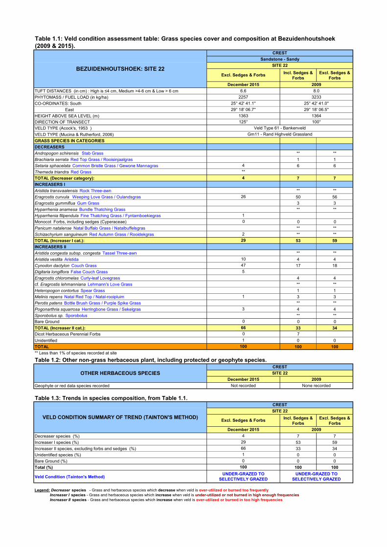
SITE NUMBER Site 22
VELD TYPE - ACOCKS Veld Type 61 - Bankenveld
VELD TYPE – MUCINA &
RUTHERFORD
Gm11 - Rand Highveld Grassland
GEOLOGY AND SOILS Sandstone - Sandy
DATE VISITED 22/12/2015
GRASS SPECIES RICHNESS (Number of grass species:
<10 spp = low; 10-19 spp = medium; >20 spp = high) 10 species (11 incl. <1% species) = Medium
GRASS SPECIES ABUNDANCE (DOMINANT SPECIES)
Cynodon dactylon (Couch Grass) – 47% Eragrostis curvula (Weeping Love Grass) – 26% Aristida vestita (Aristida) – 10%
AVERAGE GRASS TUFT DISTANCE (Water Catchment
Potential: High is ≤4 cm, Medium >4-6 cm & Low > 6cm) 6.6 cm = Low
GRASS PHYTOMASS (Fuel Load) - 3 tons/ha is threshold
for burning climax or selectively grazed areas; 4
tons/ha for other areas, including wetland ecotones.
2257 kg/ha =Medium
VELD CONDITION (according to Tainton, 1988) Under-grazed to Selectively Grazed
VELD CONDITION TREND
Veld condition trend is towards the overgrazing domain, with a decrease in abundance of the undesired climax Eragrostis curvula, but an increase in pioneer grass, Cynodon dactylon. This is to be expected (grazing impact close to water hole envisaged) - due to the impact of the new little dam attracting grazers within 100 m of the area where the veld condition is assessed.
CURRENT GRAZING CAPACITY 6.1 ha/LSU (According to Tainton’s Benchmark Method).

MANAGEMENT STRATEGY Protect against fire in 2016.
ISPD FIGURE – POSITION OF RED VERTICAL ARROW ILLUSTRATES THE CONDITION ON A DEGRADATION AXIS AND THE DIRECTION OF THE TREND CAN
BE OBSERVED FROM FOLLOWING THE ORDER OF THE ASSESSMENTS (i.e. Run 1 = Year 1, Run 2 = Year 2 etc.).
LITERATURE
ACOCKS, J.P.H. 1988. Veld Types of South Africa. Botanical Research Institute. 146 pp
BOSCH, O. J. H. and GAUGH, H. 1991. The use of degradation gradients for the assessment and ecological interpretation of range condition. Tydskrif
Weidingsveren. S. Afr. (1991), 8. (4). Pp 138-146.
MUCINA, L. & RUTHERFORD, M.C., 2006. The Vegetation of South Africa, Lesotho and Swaziland. Tien Wah Press, Singapore. 807 pp.
TAINTON, N.M. 1988. Veld and Pasture Management in South Africa. Shuter & Shooter, Pietermaritzburg. 481 pp.

VELD CONDITION ASSESSMENT SITE REPORT – DECEMBER 2015
(SEE ATTACHED TABLE)
GOOGLE IMAGE OF THE FOCUS AREA
GOOGLE IMAGE OF THE SITE
25° 43' 27.4'' 29° 20' 07.8''
FARM Bezuidenhoutshoek
22/12/2015
SITE NUMBER Site 32
VELD TYPE - ACOCKS Veld Type 61 - Bankenveld
VELD TYPE – MUCINA &
RUTHERFORD
Gm11 - Rand Highveld Grassland
GEOLOGY AND SOILS Sandstone - Sandy
DATE VISITED 22/12/2015
GRASS SPECIES RICHNESS (Number of grass species:
<10 spp = low; 10-19 spp = medium; >20 spp = high) 16 species (19 incl. <1% species) = Medium
GRASS SPECIES ABUNDANCE (DOMINANT SPECIES)
Eragrostis curvula (Weeping Love Grass) – 43% Setaria sphacelata (Common Bristle Grass) – 9% Tristachya biseriata (Tristachya ) – 9%
AVERAGE GRASS TUFT DISTANCE (Water Catchment
Potential: High is ≤4 cm, Medium >4-6 cm & Low > 6cm) 6.9 cm = Low
GRASS PHYTOMASS (Fuel Load) - 3 tons/ha is threshold
for burning climax or selectively grazed areas; 4
tons/ha for other areas, including wetland ecotones.
4473 kg/ha =Very High
VELD CONDITION (according to Tainton, 1988) Undergrazed to Selectively Grazed
VELD CONDITION TREND Trend is towards undesired climax, with E. curvula that increased significantly.
CURRENT GRAZING CAPACITY 6.3 ha/LSU (According to Tainton’s Benchmark Method).

MANAGEMENT STRATEGY Burn in autumn 2016. Apply patch mosaic burn.
ISPD FIGURE – POSITION OF RED VERTICAL ARROW ILLUSTRATES THE CONDITION ON A DEGRADATION AXIS AND THE DIRECTION OF THE TREND CAN
BE OBSERVED FROM FOLLOWING THE ORDER OF THE ASSESSMENTS (i.e. Run 1 = Year 1, Run 2 = Year 2 etc.).
LITERATURE
ACOCKS, J.P.H. 1988. Veld Types of South Africa. Botanical Research Institute. 146 pp
BOSCH, O. J. H. and GAUGH, H. 1991. The use of degradation gradients for the assessment and ecological interpretation of range condition. Tydskrif
Weidingsveren. S. Afr. (1991), 8. (4). Pp 138-146.
MUCINA, L. & RUTHERFORD, M.C., 2006. The Vegetation of South Africa, Lesotho and Swaziland. Tien Wah Press, Singapore. 807 pp.
TAINTON, N.M. 1988. Veld and Pasture Management in South Africa. Shuter & Shooter, Pietermaritzburg. 481 pp.

VELD CONDITION ASSESSMENT SITE REPORT – DECEMBER 2015
(SEE ATTACHED TABLE)
GOOGLE IMAGE OF THE FOCUS AREA
GOOGLE IMAGE OF THE SITE
25° 42' 03.6'' 29° 18' 44.0''
FARM Bezuidenhoudshoek
24/12/2015
SITE NUMBER Site 38
VELD TYPE - ACOCKS Veld Type 19 - Sourish Mixed Bushveld
VELD TYPE – MUCINA &
RUTHERFORD
Gm11 - Rand Highveld Grassland
GEOLOGY AND SOILS Sandstone - Sandy
DATE VISITED 24/12/2015
GRASS SPECIES RICHNESS (Number of grass species:
<10 spp = low; 10-19 spp = medium; >20 spp = high) 17 species (30 incl. <1% species) = Medium (High)
GRASS SPECIES ABUNDANCE (DOMINANT SPECIES)
Sporobolus festivus (Red Dropseed) – 21% Tristachya biseriata (Tristachya) – 16%
Aristida transvaalensis (Rock Three-awn ) – 16%
AVERAGE GRASS TUFT DISTANCE (Water Catchment
Potential: High is ≤4 cm, Medium >4-6 cm & Low > 6cm) 7.9 cm = Low
GRASS PHYTOMASS (Fuel Load) - 3 tons/ha is threshold
for burning climax or selectively grazed areas; 4
tons/ha for other areas, including wetland ecotones.
3203 kg/ha =High
VELD CONDITION (according to Tainton, 1988) Selectively Grazed
VELD CONDITION TREND
Trend has been towards further selective grazing and undesired climax conditions, but although veld condition is similar to the previous assessment, a reversal of the trend is not yet observed. This grassland has the record of most species recorded per square meter (less species recorded in recent years possibly due to lower rainfall conditions).
CURRENT GRAZING CAPACITY 7.5 ha/LSU (According to Tainton’s Benchmark Method).

MANAGEMENT STRATEGY Apply patch-mosaic burn in autumn 2016.
ISPD FIGURE – POSITION OF RED VERTICAL ARROW ILLUSTRATES THE CONDITION ON A DEGRADATION AXIS AND THE DIRECTION OF THE TREND CAN
BE OBSERVED FROM FOLLOWING THE ORDER OF THE ASSESSMENTS (i.e. Run 1 = Year 1, Run 2 = Year 2 etc.).
LITERATURE
ACOCKS, J.P.H. 1988. Veld Types of South Africa. Botanical Research Institute. 146 pp
BOSCH, O. J. H. and GAUGH, H. 1991. The use of degradation gradients for the assessment and ecological interpretation of range condition. Tydskrif
Weidingsveren. S. Afr. (1991), 8. (4). Pp 138-146.
MUCINA, L. & RUTHERFORD, M.C., 2006. The Vegetation of South Africa, Lesotho and Swaziland. Tien Wah Press, Singapore. 807 pp.
TAINTON, N.M. 1988. Veld and Pasture Management in South Africa. Shuter & Shooter, Pietermaritzburg. 481 pp.

VELD CONDITION ASSESSMENT SITE REPORT – DECEMBER 2015
(SEE ATTACHED TABLE)
GOOGLE IMAGE OF THE FOCUS AREA
GOOGLE IMAGE OF THE SITE
25° 42' 07.7'' 29° 19' 33.7''
FARM Bezuidenhoutshoek
23/12/2015
SITE NUMBER Site 81
VELD TYPE - ACOCKS Veld Type 61 - Bankenveld
VELD TYPE – MUCINA &
RUTHERFORD
Gm11 - Rand Highveld Grassland
GEOLOGY AND SOILS Sandstone - Sandy
DATE VISITED 23/12/2015
GRASS SPECIES RICHNESS (Number of grass species:
<10 spp = low; 10-19 spp = medium; >20 spp = high) 16 species (19 incl. <1% species) = Medium
GRASS SPECIES ABUNDANCE (DOMINANT SPECIES)
Eragrostis curvula (Weeping Love Grass) – 25% Setaria sphacelata (Common Bristle Grass) – 19% Hyparrhenia anamesa (Bundle Thatching Grass) – 15%
AVERAGE GRASS TUFT DISTANCE (Water Catchment
Potential: High is ≤4 cm, Medium >4-6 cm & Low > 6cm) 5.3 cm =Medium
GRASS PHYTOMASS (Fuel Load) - 3 tons/ha is threshold
for burning climax or selectively grazed areas; 4
tons/ha for other areas, including wetland ecotones.
4790 kg/ha =Very High
VELD CONDITION (according to Tainton, 1988) Under-grazed to Selectively Grazed
VELD CONDITION TREND This is baseline data, no trend can be established yet.
CURRENT GRAZING CAPACITY 6.0 ha/LSU (According to Tainton’s Benchmark Method).

MANAGEMENT STRATEGY Burn in autumn 2016.
ISPD FIGURE – POSITION OF RED VERTICAL ARROW ILLUSTRATES THE CONDITION ON A DEGRADATION AXIS AND THE DIRECTION OF THE TREND CAN
BE OBSERVED FROM FOLLOWING THE ORDER OF THE ASSESSMENTS (i.e. Run 1 = Year 1, Run 2 = Year 2 etc.). THIS IS BASELINE DATA, NO TREND CAN BE ESTABLISHED
YET.
LITERATURE
ACOCKS, J.P.H. 1988. Veld Types of South Africa. Botanical Research Institute. 146 pp
BOSCH, O. J. H. and GAUGH, H. 1991. The use of degradation gradients for the assessment and ecological interpretation of range condition. Tydskrif
Weidingsveren. S. Afr. (1991), 8. (4). Pp 138-146.
MUCINA, L. & RUTHERFORD, M.C., 2006. The Vegetation of South Africa, Lesotho and Swaziland. Tien Wah Press, Singapore. 807 pp.
TAINTON, N.M. 1988. Veld and Pasture Management in South Africa. Shuter & Shooter, Pietermaritzburg. 481 pp.

VELD CONDITION ASSESSMENT SITE REPORT – DECEMBER 2015
(SEE ATTACHED TABLE)
GOOGLE IMAGE OF THE FOCUS AREA
GOOGLE IMAGE OF THE SITE
25° 42' 44.2'' 29° 19' 18.5''
FARM Bezuidenhoutshoek
23/12/2015
SITE NUMBER Site 82
VELD TYPE - ACOCKS Veld Type 61 - Bankenveld
VELD TYPE – MUCINA &
RUTHERFORD
Gm11 - Rand Highveld Grassland
GEOLOGY AND SOILS Sandstone - Sandy
DATE VISITED 23/12/2015
GRASS SPECIES RICHNESS (Number of grass species:
<10 spp = low; 10-19 spp = medium; >20 spp = high) 14 species (17 incl. <1% species) = Medium
GRASS SPECIES ABUNDANCE (DOMINANT SPECIES)
Cynodon dactylon (Couch Grass) – 21% Eragrostis capensis (Heart-seed Love Grass) – 17% Hyparrhenia anamesa (Bundle Thatching Grass) – 17%
AVERAGE GRASS TUFT DISTANCE (Water Catchment
Potential: High is ≤4 cm, Medium >4-6 cm & Low > 6cm) 4.7 cm =Medium
GRASS PHYTOMASS (Fuel Load) - 3 tons/ha is threshold
for burning climax or selectively grazed areas; 4
tons/ha for other areas, including wetland ecotones.
3461 kg/ha =High
VELD CONDITION (according to Tainton, 1988) Selectively Grazed
VELD CONDITION TREND This is baseline data, no trend can be established yet.
CURRENT GRAZING CAPACITY 6.3 ha/LSU (According to Tainton’s Benchmark Method).

MANAGEMENT STRATEGY Burn in autumn 2016.
ISPD FIGURE – POSITION OF RED VERTICAL ARROW ILLUSTRATES THE CONDITION ON A DEGRADATION AXIS AND THE DIRECTION OF THE TREND CAN
BE OBSERVED FROM FOLLOWING THE ORDER OF THE ASSESSMENTS (i.e. Run 1 = Year 1, Run 2 = Year 2 etc.). THIS IS BASELINE DATA; NO TREND CAN BE ESTABLISHED
YET.
LITERATURE
ACOCKS, J.P.H. 1988. Veld Types of South Africa. Botanical Research Institute. 146 pp
BOSCH, O. J. H. and GAUGH, H. 1991. The use of degradation gradients for the assessment and ecological interpretation of range condition. Tydskrif
Weidingsveren. S. Afr. (1991), 8. (4). Pp 138-146.
MUCINA, L. & RUTHERFORD, M.C., 2006. The Vegetation of South Africa, Lesotho and Swaziland. Tien Wah Press, Singapore. 807 pp.
TAINTON, N.M. 1988. Veld and Pasture Management in South Africa. Shuter & Shooter, Pietermaritzburg. 481 pp.

VELD CONDITION ASSESSMENT SITE REPORT – DECEMBER 2015
(SEE ATTACHED TABLE)
GOOGLE IMAGE OF THE FOCUS AREA
GOOGLE IMAGE OF THE SITE
25° 43' 28.2'' 29° 18' 16.8''
FARM Bezuidenhoutshoek
23/12/2015
SITE NUMBER Site 83
VELD TYPE - ACOCKS Veld Type 61 - Bankenveld
VELD TYPE – MUCINA &
RUTHERFORD
Gm11 - Rand Highveld Grassland
GEOLOGY AND SOILS Sandstone - Sandy
DATE VISITED 23/12/2015
GRASS SPECIES RICHNESS (Number of grass species:
<10 spp = low; 10-19 spp = medium; >20 spp = high) 12 species (20 incl. <1% species) = Medium (High)
GRASS SPECIES ABUNDANCE (DOMINANT SPECIES)
Tristachya biseriata (Tristachya) – 43% Loudetia simplex (Common Russet Grass) – 36% Setaria sphacelata (Common Bristle Grass) – 5%
AVERAGE GRASS TUFT DISTANCE (Water Catchment
Potential: High is ≤4 cm, Medium >4-6 cm & Low > 6cm) 8.9 cm =Low
GRASS PHYTOMASS (Fuel Load) - 3 tons/ha is threshold
for burning climax or selectively grazed areas; 4
tons/ha for other areas, including wetland ecotones.
5070 kg/ha =Very High
VELD CONDITION (according to Tainton, 1988) Under-grazed
VELD CONDITION TREND This is baseline data, no trend can be established yet.
CURRENT GRAZING CAPACITY 8.8 ha/LSU (According to Tainton’s Benchmark Method).

MANAGEMENT STRATEGY Burn in autumn 2016.
ISPD FIGURE – POSITION OF RED VERTICAL ARROW ILLUSTRATES THE CONDITION ON A DEGRADATION AXIS AND THE DIRECTION OF THE TREND CAN
BE OBSERVED FROM FOLLOWING THE ORDER OF THE ASSESSMENTS (i.e. Run 1 = Year 1, Run 2 = Year 2 etc.). THIS IS BASELINE DATA; NO TREND CAN BE ESTABLISHED
YET.
LITERATURE
ACOCKS, J.P.H. 1988. Veld Types of South Africa. Botanical Research Institute. 146 pp
BOSCH, O. J. H. and GAUGH, H. 1991. The use of degradation gradients for the assessment and ecological interpretation of range condition. Tydskrif
Weidingsveren. S. Afr. (1991), 8. (4). Pp 138-146.
MUCINA, L. & RUTHERFORD, M.C., 2006. The Vegetation of South Africa, Lesotho and Swaziland. Tien Wah Press, Singapore. 807 pp.
TAINTON, N.M. 1988. Veld and Pasture Management in South Africa. Shuter & Shooter, Pietermaritzburg. 481 pp.

VELD CONDITION ASSESSMENT SITE REPORT – DECEMBER 2015
(SEE ATTACHED TABLE)
GOOGLE IMAGE OF THE FOCUS AREA
GOOGLE IMAGE OF THE SITE
25° 44' 50.3'' 29° 19' 12.8''
FARM Bezuidenhoutshoek
24/12/2015
SITE NUMBER Site 84
VELD TYPE - ACOCKS Veld Type 61 - Bankenveld
VELD TYPE – MUCINA &
RUTHERFORD
Gm11 - Rand Highveld Grassland
GEOLOGY AND SOILS Sandstone - Sandy
DATE VISITED 24/12/2015
GRASS SPECIES RICHNESS (Number of grass species:
<10 spp = low; 10-19 spp = medium; >20 spp = high) 13 species (23 incl. <1% species) = Medium (High)
GRASS SPECIES ABUNDANCE (DOMINANT SPECIES)
Aristida junciformis (Ngongoni Three-awn) – 40% Eragrostis gummiflua (Gum Grass) – 14% Eragrostis capensis (Heart-seed Love Grass) – 11%
AVERAGE GRASS TUFT DISTANCE (Water Catchment
Potential: High is ≤4 cm, Medium >4-6 cm & Low > 6cm) 10.5 cm =Low
GRASS PHYTOMASS (Fuel Load) - 3 tons/ha is threshold
for burning climax or selectively grazed areas; 4
tons/ha for other areas, including wetland ecotones.
6133 kg/ha =Very High
VELD CONDITION (according to Tainton, 1988) Under-grazed
VELD CONDITION TREND This is baseline data, no trend can be established yet.
CURRENT GRAZING CAPACITY 11.9 ha/LSU (According to Tainton’s Benchmark Method).

MANAGEMENT STRATEGY Burn in autumn 2016.
ISPD FIGURE – POSITION OF RED VERTICAL ARROW ILLUSTRATES THE CONDITION ON A DEGRADATION AXIS AND THE DIRECTION OF THE TREND CAN
BE OBSERVED FROM FOLLOWING THE ORDER OF THE ASSESSMENTS (i.e. Run 1 = Year 1, Run 2 = Year 2 etc.). THIS IS BASELINE DATA; NO TREND CAN BE ESTABLISHED
YET.
LITERATURE
ACOCKS, J.P.H. 1988. Veld Types of South Africa. Botanical Research Institute. 146 pp
BOSCH, O. J. H. and GAUGH, H. 1991. The use of degradation gradients for the assessment and ecological interpretation of range condition. Tydskrif
Weidingsveren. S. Afr. (1991), 8. (4). Pp 138-146.
MUCINA, L. & RUTHERFORD, M.C., 2006. The Vegetation of South Africa, Lesotho and Swaziland. Tien Wah Press, Singapore. 807 pp.
TAINTON, N.M. 1988. Veld and Pasture Management in South Africa. Shuter & Shooter, Pietermaritzburg. 481 pp.

APPENDIX C
TABLES

Incl. Sedges & Forbs
Excl. Sedges & Forbs
TUFT DISTANCES (in cm) : High is ≤4 cm, Medium >4-6 cm & Low > 6 cmPHYTOMASS / FUEL LOAD (in kg/ha)CO-ORDINATES: South EastHEIGHT ABOVE SEA LEVEL (m)DIRECTION OF TRANSECTVELD TYPE (Acock's, 1953 ) VELD TYPE (Mucina & Rutherford, 2006) GRASS SPECIES IN CATEGORIESDECREASERSAndropogon schirensis Stab GrassBewsia biflora False Love Grass 4 4Brachiaria serrata Red Top Grass / RooisinjaalgrasDigitaria brazzae Brown Finger GrassDiheteropogon amplectens Broad-leaved Bluestem / Breeblaar Andropogon ** **Setaria nigrirostris Rootstock Manna Grass 10 10Setaria sphacelata Common Bristle Grass / Gewone Mannagras 38 43Themeda triandra Rooigras 3 4TOTAL (Decreaser category): 55 61INCREASERS ICymbopogon caesius Broad-leaved Turpentine Grass ** **Cymbopogon pospischilii Narrow-leaved Turpentine GrassElionurus muticus Wire Grass / Koperdraad / Suurpol 4 4Eragrostis curvula Weeping Love Grass / OulandsgrasHyparrhenia anamesa Bundle Thatching Grass ** **Hyparrhenia filipendula Fine Thatching GrassMelinis nerviglumis Bristle-leaved Red Top 1 1Monocot Forbs, including sedges (Cyperaceae) 2cf. Pennisetum thunbergii PennisetumTrachypogon spicatus Giant Spear Grass / Reusepylgras 3 3Triraphis andropogonoides Broom Needle GrassTristachya leucothrix Hairy Trident Grass / Harige-drieblomgras 25 25TOTAL (Increaser I cat.): 35 33INCREASERS IIAristida bipartita Rolling GrassCynodon dactylon Couch Grass / KweekEragrostis capensis Heart-seed Love Grass / Hartjie-eragrostisEragrostis plana Tough Love GrassEragrostis racemosa Narrow Heart Love Grass / Smalhartjie-eragrostis 2 2Eragrostis cf. rotifer Pearly Love GrassHeteropogon contortus Spear Grass 2 2Microchloa caffra Pincushion Grass 2 2Sporobolus africanus Ratstail DropseedSporobolus festivus Red DropseedBare Ground 0 0TOTAL (Increaser II cat.): 6 6Dicot Herbaceous Perennial Forbs 4Unidentified 0 0TOTAL 100 100** Less than 1% of species recorded at siteTable 1.2: Other non-grass herbaceous plant, including protected or geophyte species.
Geophyte or red data species recorded
Table 1.3: Trends in species composition, from Table 1.1.
Incl. Sedges & Forbs
Excl. Sedges & Forbs
Decreaser species (%) 55 61Increaser I species (%) 35 33Increaser II species, excluding forbs and sedges (%) 6 6Unidentified species (%) 0 0Bare Ground (%) 0 0Total (%) 100 100Veld Condition (Tainton's Method)
Table 1.4 : Fuel load (in kg/ha).December 2015 February 2015 2009
> 4 000 Very High X3 000-4 000 High2 000-3 000 Mediumless 2000 Low X X
Table 1.5: Summary.
Tuft distance (cm)Water Catchment Potential (High is ≤4 cm, Medium >4-6 cm & Low > 6 cm)Number of grass species present per 2500 square meters (excl. and incl. <1% species)Grass Species Richness (High is = 20-30 spp, Low < 10 species)Fuel load (4 tons per ha = threshhold for burning)Fuel load potential (from Table 1.4)Condition on ISPD Degradation Axis (%) - Norm between 60% and 80%ISPD Veld Condition AssessmentTainton's method - LAU/ha & ha/LAU (calculated from veld condition, habitat & soil info) 0.24 4.1 0.24 4.2Current Grazing Capacity (High <4ha/LAU; Medium 4-7ha/LAU & Low >7ha/LAU)
Notes
Management Recommendation
00
100
CREST
PROTECT AGAINST FIRE IN 2016
Low78.5
GOOD
Medium
Low
****
5
**
2
**
**
2
**
88
7
**
13056
29° 20' 07.2''1461320°
1
Excl. Sedges & ForbsDecember 2015
SITE 13Diabase - Red Sandy Clay Loam
CREST
Gm11 - Rand Highveld GrasslandVeld Type 61 - Bankenveld
3.41854
25° 44' 43.3''
**
5
1
SITE 13
88
**
0
4.0
ISPD 3614
Medium
**
**
1585
**7
1
GOOD
SITE NUMBER: 13
CRESTSITE 13
CLIMAX
POTENTIAL
7141
Legend: Decreaser species - Grass and herbaceous species which decrease when veld is over-utilized or burned too frequently
VOLUME (kg/ha)
ISPD 3339
100
500
85
2
11
**
**
**
**
****
10000
140
3
3
BEZUIDENHOUTSHOEK: SITE 13
8526912
Excl. Sedges & ForbsFebruary 2015
February 2015
Excl. Sedges & ForbsDecember 2015
None recorded
25° 44' 43.2''29° 20' 07.4''
1478180°
2009
2009
Excl. Sedges & ForbsFebruary 2015
OTHER HERBACEOUS SPECIES
VELD CONDITION SUMMARY OF TREND (TAINTON'S METHOD)
SITE 13December 2015None recorded
CREST
1476
4.1
29° 20' 06.4''
None recorded
4.01585
1
**
1
11 (14)
4.1Medium
ISPD 1762
Table 1.1: Veld condition assessment table: Grass species cover and composition at Bezuidenhoutshoek (2009 & 2015).
310°
25° 44' 41.5''48102009
3.4
BURN IN 2009
81.7CLIMAX
Very High
Increaser I species - Grass and herbaceous species which increase when veld is under-utilized or not burned in high enough frequencies Increaser II species - Grass and herbaceous species which increase when veld is over-utilized or burned in too high frequencies
SUMMARY
4810
PROTECT AGAINST FIRE IN 2015
December 2015High
8 (17)Low (Medium)
1854
The site was assessed as the Sweet Veld was recently burned. Black Wildebeest in area. Shortly grazed (1-5cm) especially
to the east of this survey area.
GOOD
High11 (21)
The reason for the VCA is to assess the impact after the burn recently (2014). Herd
of Blue Wildebeest present in the area (resting). Within the general area where it was most recently burned (May 2015;Burn
4), but outside the burned area.
72.0
GOOD100
00
Not applicableMedium
Medium (High)
February 2015 2009

Incl. Sedges & Forbs
Excl. Sedges & Forbs
TUFT DISTANCES (in cm) : High is ≤4 cm, Medium >4-6 cm & Low > 6 cmPHYTOMASS / FUEL LOAD (in kg/ha)CO-ORDINATES: South EastHEIGHT ABOVE SEA LEVEL (m)DIRECTION OF TRANSECTVELD TYPE (Acock's, 1953 ) VELD TYPE (Mucina & Rutherford, 2006) GRASS SPECIES IN CATEGORIESDECREASERSDigitaria brazzae Brown Finger Grass 3 3Digitaria eriantha Finger Grass / VingergrasSetaria sphacelata Common Bristle Grass / Gewone Mannagras ** **TOTAL (Decreaser category): 3 3INCREASERS IAristida transvaalensis Rock Three-awnEragrostis curvula Weeping Love Grass / Oulandsgras 40 47Eragrostis gummiflua Gum Grass ** **Hyparrhenia anamesa Bundle Thatching GrassMonocot Forbs, including sedges (Cyperaceae) 10Schizachyrium sanguineum Red Autumn Grass / Rooidekgras ** **Tristachya rehmannii Broom Trident Grass 2 2TOTAL (Increaser I cat.): 52 49INCREASERS IIAristida congesta subsp. congesta Tassel Three-awn 1 1Aristida vestita Aristida 2 2Cynodon dactylon Couch Grass ** **Eragrostis chloromelas Curly-leaf Lovegrass ** **Melinis repens Natal Red Top / Natal-rooipluim 7 7Microchloa caffra Pincushion GrassPerotis patens Bottle Brush Grass / Purple Spike Grass 20 20Pogonarthria squarrosa Herringbone Grass / Sekelgras 12 18Bare Ground 0 0TOTAL (Increaser II cat.): 42 48Dicot Herbaceous Perennial Forbs 3Unidentified 0 0TOTAL 100 100** Less than 1% of species recorded at siteTable 1.2: Other non-grass herbaceous plant, including protected or geophyte species.
Geophyte or red data species recorded
Table 1.3: Trends in species composition, from Table 1.1.
Incl. Sedges & Forbs
Excl. Sedges & Forbs
Decreaser species (%) 3 3Increaser I species (%) 52 49Increaser II species, excluding forbs and sedges (%) 42 48Unidentified species (%) 0 0Bare Ground (%) 0 0Total (%) 100 100Veld Condition (Tainton's Method)
Table 1.4 : Fuel load (in kg/ha).December 2015 2009
> 4 000 Very High3 000-4 000 High X2 000-3 000 Mediumless 2000 Low X
Table 1.5: Summary.
Tuft distance (cm)Water Catchment Potential (High is ≤4 cm, Medium >4-6 cm & Low > 6 cm)Number of grass species present per 2500 square meters (excl. and incl. <1% species)Grass Species Richness (High is = 20-30 spp, Low < 10 species)Fuel load (4 tons per ha = threshhold for burning)Fuel load potential (from Table 1.4)Condition on ISPD Degradation Axis (%) - Norm between 60% and 80%ISPD Veld Condition AssessmentTainton's method - LAU/ha & ha/LAU (calculated from veld condition, habitat & soil info) 0.19 5.3Current Grazing Capacity (High <4ha/LAU; Medium 4-7ha/LAU & Low >7ha/LAU)Notes
Management Recommendation PROTECT AGAINST FIRE IN 2016
MediumThe reason for the VCA is to assess the impact after the 2014 burn. Herd of Blue
Wildebeest in the area.
Low (Medium)1711Low80.0
SELECTIVELY GRAZED
PROTECT AGAINST FIRE IN 2009
SITE NUMBER: 21
December 2015ISPD 3615
Not assessed
5.2Medium9 (13)
CRESTSITE 21
66.6
10000174736
CRESTSITE 21
December 2015Not recorded
472
0
17
9
19
3
3617
**
**1
42
3**
25° 42' 37.9''29° 18' 00.0''
1361
Sandstone - Sandy
Excl. Sedges & Forbs
300°1370100°
25° 42' 37.8''
Legend: Decreaser species - Grass and herbaceous species which decrease when veld is over-utilized or burned too frequently
VOLUME (kg/ha)
December 2015Excl. Sedges & Forbs
SELECTIVELY GRAZED
2009
0
0
4
Increaser I species - Grass and herbaceous species which increase when veld is under-utilized or not burned in High enough frequencies Increaser II species - Grass and herbaceous species which increase when veld is over-utilized or burned in too High frequencies
SUMMARY
OTHER HERBACEOUS SPECIES
VELD CONDITION SUMMARY OF TREND (TAINTON'S METHOD)
ISPD 1770
None recorded
SELECTIVELY GRAZED
POTENTIAL
2009
Table 1.1: Veld condition assessment table: Grass species cover and composition at Bezuidenhoutshoek (2009 & 2015).
3721
20095.7
CREST
SITE 21
December 2015
BEZUIDENHOUTSHOEK: SITE 21
5.21711
29° 18' 00.4''
SITE 21
**
CREST
Veld Type 61 - Bankenveld Gm11 - Rand Highveld Grassland
100
0
SELECTIVELY GRAZED
High3721
2009
Low (Medium)8 (13)
5.7Medium
Incl. Sedges & Forbs
Excl. Sedges & Forbs
TUFT DISTANCES (in cm) : High is ≤4 cm, Medium >4-6 cm & Low > 6 cmPHYTOMASS / FUEL LOAD (in kg/ha)CO-ORDINATES: South EastHEIGHT ABOVE SEA LEVEL (m)DIRECTION OF TRANSECTVELD TYPE (Acock's, 1953 ) VELD TYPE (Mucina & Rutherford, 2006) GRASS SPECIES IN CATEGORIESDECREASERSAndropogon schirensis Stab Grass ** **Brachiaria serrata Red Top Grass / Rooisinjaalgras 1 1Setaria sphacelata Common Bristle Grass / Gewone Mannagras 6 6Themeda triandra Red GrassTOTAL (Decreaser category): 7 7INCREASERS IAristida transvaalensis Rock Three-awn ** **Eragrostis curvula Weeping Love Grass / Oulandsgras 50 56Eragrostis gummiflua Gum Grass 3 3Hyparrhenia anamesa Bundle Thatching Grass ** **Hyparrhenia filipendula Fine Thatching Grass / FyntamboekiegrasMonocot Forbs, including sedges (Cyperaceae) 0 0Panicum natalense Natal Buffalo Grass / Natalbuffelsgras ** **Schizachyrium sanguineum Red Autumn Grass / Rooidekgras ** **TOTAL (Increaser I cat.): 53 59INCREASERS IIAristida congesta subsp. congesta Tassel Three-awn ** **Aristida vestita Aristida 4 4Cynodon dactylon Couch Grass 17 18Digitaria longiflora False Couch GrassEragrostis chloromelas Curly-leaf Lovegrass 4 4cf. Eragrostis lehmanniana Lehmann's Love Grass ** **Heteropogon contortus Spear Grass 1 1Melinis repens Natal Red Top / Natal-rooipluim 3 3Perotis patens Bottle Brush Grass / Purple Spike Grass ** **Pogonarthria squarrosa Herringbone Grass / Sekelgras 4 4Sporobolus sp. Sporobolus ** **Bare Ground 0 0TOTAL (Increaser II cat.): 33 34Dicot Herbaceous Perennial Forbs 7Unidentified 0 0TOTAL 100 100** Less than 1% of species recorded at siteTable 1.2: Other non-grass herbaceous plant, including protected or geophyte species.
Geophyte or red data species recorded
Table 1.3: Trends in species composition, from Table 1.1.
Incl. Sedges & Forbs
Excl. Sedges & Forbs
Decreaser species (%) 7 7Increaser I species (%) 53 59Increaser II species, excluding forbs and sedges (%) 33 34Unidentified species (%) 0 0Bare Ground (%) 0 0Total (%) 100 100Veld Condition (Tainton's Method)
100°Veld Type 61 - Bankenveld
Gm11 - Rand Highveld Grassland
4
4
25° 42' 41.0''
2009
136429° 18' 06.5''
100
29° 18' 06.7''
Table 1.1: Veld condition assessment table: Grass species cover and composition at Bezuidenhoutshoek (2009 & 2015).
3233
20098.0
SITE 22Sandstone - Sandy
CREST
Excl. Sedges & ForbsDecember 2015
6.6
December 2015
OTHER HERBACEOUS SPECIES
VELD CONDITION SUMMARY OF TREND (TAINTON'S METHOD)
None recorded
Increaser I species - Grass and herbaceous species which increase when veld is under-utilized or not burned in high enough frequencies Increaser II species - Grass and herbaceous species which increase when veld is over-utilized or burned in too high frequencies
SITE 22
UNDER-GRAZED TO SELECTIVELY GRAZED
2009
Legend: Decreaser species - Grass and herbaceous species which decrease when veld is over-utilized or burned too frequently
Excl. Sedges & Forbs
2
CREST
4710
225725° 42' 41.1''
5
1363125°
29
1
660
0
0
1
3
1
26
100016629
**
CRESTSITE 22
December 2015Not recorded
4
UNDER-GRAZED TO SELECTIVELY GRAZED
BEZUIDENHOUTSHOEK: SITE 22

Table 1.4 : Fuel load (in kg/ha).December 2015 2009
> 4 000 Very High3 000-4 000 High X2 000-3 000 Medium Xless 2000 Low
Table 1.5: Summary.
Tuft distance (cm)Water Catchment Potential (High is ≤4 cm, Medium >4-6 cm & Low > 6 cm)Number of grass species present per 2500 square meters (excl. and incl. <1% species)Grass Species Richness (High is = 20-30 spp, Low < 10 species)Fuel load (4 tons per ha = threshhold for burning)Fuel load potential (from Table 1.4)Condition on ISPD Degradation Axis (%) - Norm between 60% and 80%ISPD Veld Condition AssessmentTainton's method - LAU/ha & ha/LAU (calculated from veld condition, habitat & soil info) 0.16 6.1Current Grazing Capacity (High <4ha/LAU; Medium 4-7ha/LAU & Low >7ha/LAU)
Notes
Management Recommendation PROTECT AGAINST FIRE IN 2009
70.4UNDER-GRAZED TO
SELECTIVELY GRAZED
High3233
2009
Medium10 (19)
8.0Low
SUMMARY ISPD 1771
POTENTIALVOLUME (kg/ha)
Medium52.3
SITE NUMBER: 22
CRESTSITE 22
December 2015ISPD 3616
6.6
UNDER-GRAZED TO SELECTIVELY GRAZED
PROTECT AGAINST FIRE IN 2016
Not assessed
The reason for the VCA is to assess the grazing impact after the creation of the new water point. In recent years a waterhole has
been placed within 100m of survey site which is a significant factor in the change in VCA.
Outside Burn 6 - unburned area. Grass grazed short by Zebra and Warthog. Digitaria longiflora is a new species record for
Bezuidenhoudshoek.
Medium
Low10 (11)Medium
2257

Incl. Sedges & Forbs
Excl. Sedges & Forbs
Incl. Sedges & Forbs
Excl. Sedges & Forbs
TUFT DISTANCES (in cm) : High is ≤4 cm, Medium >4-6 cm & Low > 6 cmPHYTOMASS / FUEL LOAD (in kg/ha)CO-ORDINATES: South EastHEIGHT ABOVE SEA LEVEL (m)DIRECTION OF TRANSECTVELD TYPE (Acock's, 1953 ) VELD TYPE (Mucina & Rutherford, 2006) GRASS SPECIES IN CATEGORIESDECREASERSAndropogon schirensis Stab Grass 1 1 ** **Bewsia biflora False Love Grass 2 2Brachiaria serrata Red Top Grass / Rooisinjaalgras 1 1 ** **Digitaria brazzae Brown Finger Grass 4 4 1 1Diheteropogon amplectens Broad-leaved Bluestem 1 1 4 4Monocymbium ceresiiforme Boat Grass / Bootjiesgras ** **Setaria sphacelata Common Bristle Grass / Gewone Mannagras 1 1 12 12Themeda triandra Red Grass 5 5 6 8TOTAL (Decreaser category): 13 13 25 27INCREASERS IAristida transvaalensis Rock Three-awn 1 1Ctenium concinnum Sickle Grass / SekelgrasCymbopogon caesius Broad-leaved Turpentine Grass ** **Elionurus muticus Wire Grass / Koperdraad / Suurpol 5 5Eragrostis curvula Weeping Love Grass / Oulandsgras 3 4 2 2Eragrostis gummiflua Gum Grass ** **Hyparrhenia cf. filipendula Fine Thatching Grass / Fyntamboekiegras ** *****Loudetia simplex Common Russet Grass 5 5 5 5Melinis nerviglumis Bristle-leaved Red Top 4 4 6 6Monocot Forbs, including sedges (Cyperaceae) 2 1Panicum natalense Natal PanicumSchizachyrium sanguineum Red Autumn Grass / Rooidekgras ** ** 4 6Schizachyrium sp. SchizachyriumSporobolus pectinatus Fringed Dropseed / Kammetjiesgras 1 1 1 1Trachypogon spicatus Giant Spear Grass 2 2 1 1Tristachya biseriata Tristachya 53 54 39 44Tristachya rehmannii Broom Trident Grass ** **TOTAL (Increaser I cat.): 76 76 59 65INCREASERS IIAristida congesta subsp. congesta Tassel Three-awnAristida cf. diffusa Iron Grass 5 5 4 5Aristida vestita AristidaCynodon dactylon Couch Grass / KweekDigitaria longiflora False Couch GrassDigitaria monodactyla One Finger Grass / Eenvingergras 1 1Eragrostis capensis Hartjie-eragrostis ** **Eragrostis chloromelas Curly-leaf Lovegrass ** **Eragrostis lehmanniana Lehmann's Love Grass ** **Eragrostis plana Tough Love GrassEragrostis racemosa Narrow Heart Love Grass 4 4 1 1Eragrostis sclerantha Wooly Love Grass 1 1 ** 1Heteropogon contortus Spear GrassMelinis repens Natal Red Top / Natal-rooipluim 1 1 ** **Microchloa caffra Pincushion GrassPerotis patens Bottle Brush Grass / Purple Spike GrassPogonarthria squarrosa Herringbone Grass / Sekelgras ** ** ** **Trichoneura grandiglumis Rolling GrassBare Ground 0 0 0 0TOTAL (Increaser II cat.): 11 11 6 8Dicot Herbaceous Perennial Forbs 0 10Unidentified 0 0 0 0TOTAL 100 100 100 100** Less than 1% of species recorded at site*** Loudetia simplex includes both Loudetia simplex and Loudetia flavida .Table 1.2: Other non-grass herbaceous plant, including protected or geophyte species.
Geophyte or red data species recorded
Table 1.3: Trends in species composition, from Table 1.1.
Incl. Sedges & Forbs
Excl. Sedges & Forbs
Incl. Sedges & Forbs
Excl. Sedges & Forbs
Decreaser species (%) 13 13 25 27Increaser I species (%) 76 76 59 65Increaser II species (%) 11 11 6 8Bare Ground (%) 0 0 0 0Dicot Herbaceous Perennial Forbs (%) 0 0 10 0Unidentified species (%) 0 0 0 0Total (%) 100 100 100 100Veld Condition (Tainton's Method)
2009
Legend: Decreaser species - Grass and herbaceous species which decrease when veld is over-utilized or burned too frequently
2012OTHER HERBACEOUS SPECIES
Increaser I species - Grass and herbaceous species which increase when veld is under-utilized or not burned in high enough frequencies
VELD CONDITION SUMMARY OF TREND (TAINTON'S METHOD)
1504m
533625° 43' 36.5''
SITE 32
UNDERGRAZED
29° 20' 07.9''
240°
25° 43' 27.5''
2009
SITE 32
2012
None recordedNone recorded
Table 1.1: Veld condition assessment table: Grass species cover and composition at Bezuidentoudshoek (2009 - 2015).
1495m
4012
20098.6
Gymnosporia tenuispina / Xerophyta retinervis / Protea welwitchii climax grassland / open shrubland
100° 10°
UNDERGRAZED
CREST
BEZUIDENHOUTSHOEK: SITE 32Excl. Sedges & Forbs
February 2015
SITE 32B
12
SITE 32December 2015
December 2015
23
8.91963
25° 43' 32.6''29° 19' 59.2''
1499m
SITE 32BExcl. Sedges & Forbs
February 2015
February 2015None recorded
12**
UNDERGRAZED TO SELECTIVELY GRAZED
100
1**2
**11
1
1
**
**
4
1
9
16
65113**
**
5
3
SITE 32B
2
13
10000
230
7
**
2
4
1
**3
**
**
December 2015Excl. Sedges & Forbs
SITE 32
1485m350°
Gm11 - Rand Highveld GrasslandVeld Type 61 - Bankenveld
Sandstone - SandyCREST
6.94473
25° 43' 27.4''29° 20' 07.8''
6.9
SITE 32
2012
29° 19' 58.0''
21
1
9619
7
431
**1
1
9
63
0
5
1800
100
1
**
517**
CRESTSITE 32
None recorded
Excl. Sedges & Forbs
196318
65
000
100UNDERGRAZED TO
SELECTIVELY GRAZED
000
Increaser II species - Grass and herbaceous species which increase when veld is over-utilized or burned in too high frequencies

Table 1.4 : Fuel load (in kg/ha).December 2015 February 2015 2012 2009
> 4 000 Very High X X X3 000-4 000 High2 000-3 000 Mediumless 2000 Low X
Table 1.5: Summary.
Tuft distance (cm)Water Catchment Potential (High is ≤4 cm, Medium >4-6 cm & Low > 6 cm)Number of grass species present per 2500 square meters (excl. and incl. <1% species)Grass Species Richness (High is = 20-30 spp, Low < 10 species)Fuel load (4 tons per ha = threshhold for burning)Fuel load potential (from Table 1.4)Condition on ISPD Degradation Axis (%) - Norm between 60% and 80%ISPD Veld Condition AssessmentTainton's method - LAU/ha & ha/LAU (calculated from veld condition, habitat & soil info) 0.16 6.3 0.12 8.3Current Grazing Capacity (High <4ha/LAU; Medium 4-7ha/LAU & Low >7ha/LAU)
Notes
Management Recommendation
ISPD 1780
BURN IN 2012
6.9Low
SUMMARY
Medium (High)16 (22)
Low
BURN IN 2009
86.7UNDERGRAZED
Very High4012
PROTECT AGINST FIRE IN 2015
POTENTIALVOLUME (kg/ha)
SITE 32ISPD 2287
2012 2009February 2015
SITE 32B
1963Low78.9
UNDERGRAZED TO SELECTIVELY GRAZED
5336
Low20 (31)
High
8.6
Very High92.1
UNDERGRAZED
Not applicable
18 (26)Medium (High)
Not applicable
8.9
ISPD 3345
160m SW from original Site 32. The area was assessed as it is an area of concern
after being burned. There coud be a grazing impact which could result in a
negative trend. 3 Blue Wildebeest bulls in the area. Grass shortly grazed in patches
(1-5cm). Shallow sandy soils on rocky sandstone. Mosaic of patches shortly
grazed and taller ungrazed grass (where soil is deeper).
Low
CRESTSITE 32
SITE NUMBER: 32
ISPD 3617
6.9Low
16 (19)Medium
4473
December 2015
Very High82.1
UNDERGRAZED TO SELECTIVELY GRAZED
Medium
The reason for the VCA is this site is a potential autumn burn area. The site is outside (North) of Burn 3 i.e. unburned
veld. Rocky Sandstone area.
BURN IN AUTUMN 2016

Incl. Sedges & Forbs
Excl. Sedges & Forbs
Incl. Sedges & Forbs
Excl. Sedges & Forbs
TUFT DISTANCES (in cm) : High is ≤4 cm, Medium >4-6 cm & Low > 6 cmPHYTOMASS / FUEL LOAD (in kg/ha)CO-ORDINATES: South EastHEIGHT ABOVE SEA LEVEL (m)DIRECTION OF TRANSECTVELD TYPE (Acock's, 1953 ) VELD TYPE (Mucina & Rutherford, 2006) GRASS SPECIES IN CATEGORIESDECREASERSAndropogon chinensis Hairy Blue Grass 1 1Andropogon schirensis Stab Grass ** ** 1 1Bewsia biflora False Love Grass ** **Brachiaria brizantha Common Signal Grass 2 2 1 1Brachiaria nigropedata Black-footed Grass ** ** ** **Brachiaria serrata Red Top Grass / Rooisinjaalgras 2 2 1 1Diheteropogon amplectens Broad-leaved Bluestem ** ** 2 2Eustachys paspaloides Brown Rhodes Grass ** **Setaria sphacelata Common Bristle Grass / Gewone Mannagras 10 10 6 6Themeda triandra Red Grass 2 2 4 4TOTAL (Decreaser category): 16 16 16 16INCREASERS Icf. Alloteropsis semialata Black-seed Grass / DonkersaadgrasAndropogon eucomus Snowflake Grass ** **Aristida meridionalis Giant Three-awn ** ** ** **Aristida transvaalensis Rock Three-awn 10 10 ** **Arundinella nepalensis River Grass ** **Cymbopogon caesius Broad-leaved Turpentine Grass ** **Elionurus muticus Wire Grass / Koperdraad / SuurpolEragrostis curvula Weeping Love Grass / Oulandsgras ** ** 1 1Eragrostis gummiflua Gum Grass ** ** 3 3Eragrostis racemosa Narrow Heart Love Grass 4 5*Hyparrhenia anamesa Bundle Thatching Grass ** ** ** **Hyparrhenia dregeana Thatching Grass ** *****Loudetia simplex Common Russet Grass 4 4 5 5Melinis nerviglumis Bristle-leaved Red Top ** ** 1 1Monocot Forbs, including sedges (Cyperaceae) 0 4Panicum natalense Natal Panicum 12 12Paspalum notatum Bahia GrassRendlia altera Mahem's Crest 2 2Schizachyrium sanguineum Red Autumn Grass / Rooidekgras 4 4 13 14Sporobolus centrifugus Olive DropseedTrachypogon spicatus Giant Spear Grass 2 2 ** **Tristachya biseriata Tristachya 24 24 12 13Tristachya rehmannii Broom Trident Grass ** **Urelytrum agropyroides Quinine Grass 7 8 1 1TOTAL (Increaser I cat.): 63 64 46 45INCREASERS IIAristida congesta subsp. barbicollis Spreading Three-awn ** **Aristida congesta subsp. congesta Tassel Three-awn ** **Aristida cf. diffusa Iron Grass 19 20Cynodon dactylon Couch Grass ** **Digitaria longiflora False Couch GrassDigitaria monodactyla One Finger Grass / Eenvingergras 2 2 5 6Eragrostis capensis Heart-seed Love Grass / Hartjiesgras ** **Eragrostis chloromelas Curly-leaf Lovegrass 5 6Eragrostis nindensis Wether Love Grass 3 3Eragrostis racemosa Narrow Heart Love Grass 12 12Heteropogon contortus Spear Grass ** ** ** **Melinis repens Natal Red Top / Natal-rooipluim ** ** ** **Microchloa caffra Pincushion GrassPerotis patens Bottle Brush Grass / Purple Spike Grass ** **Pogonarthria squarrosa Herringbone Grass / Sekelgras 2 2 2 2Sporobolus africanus Ratstail Dropseed ** **Sporobolus festivus Red DropseedSporobolus ioclados Pan DropseedSporobolus sp. SporobolusSporobolus stapfianus Fibrous Dropseed ** **Tricholaena monachne Blousaadgras ** **Trichoneura grandiglumis Rolling Grass / Waaigras 4 4 2 2Bare Ground 0 0 0 0TOTAL (Increaser II cat.): 20 20 36 39Dicot Herbaceous Perennial Forbs 1 2Unidentified 0 0 0 0TOTAL 100 100 100 100
** Less than 1% of species recorded at site*** Loudetia simplex includes both Loudetia simplex and Loudetia flavida .Table 1.2: Other non-grass herbaceous plant, including protected or geophyte species.
Geophyte or red data species recorded
Table 1.3: Trends in species composition, from Table 1.1.
Incl. Sedges & Forbs
Excl. Sedges & Forbs
Incl. Sedges & Forbs
Excl. Sedges & Forbs
Decreaser species (%) 16 16 16 16Increaser I species (%) 63 64 46 45Increaser II species (%) 20 20 36 39Bare Ground (%) 0 0 0 0Dicot Herbaceous Perennial Forbs (%) 1 0 2 0Unidentified species (%) 0 0 0 0Total (%) 100 100 100 100Veld Condition (Tainton's Method)
100
**
03200
7****2**
21
**2
**51
****
3
**16
1
2
10**
**111
16
**1
13117
CREST
7.93203
Gm11 - Rand Highveld GrasslandVeld Type 19 - Sourish Mixed Bushveld
25° 42' 03.6''
2012
1330m
Not recorded
Excl. Sedges & ForbsDecember 2015
29° 18' 44.0''1325m
210°
CREST
* Hyparrhenia anamesa, Hyparrhenia filipendula and Hyparrhenia hirta grouped together.
2013
2013
SELECTIVELY GRAZED to UNDER-GRAZED
SITE 38
2013
5821
255°
5011
CRESTSITE 38
SELECTIVELY GRAZED
Increaser II species - Grass and herbaceous species which increase when veld is over-utilized or burned in too high frequencies
2012
3
VELD CONDITION SUMMARY OF TREND (TAINTON'S METHOD)
December 2015
December 2015
Not recorded
1
2012
Increaser I species - Grass and herbaceous species which increase when veld is under-utilized or not burned in high enough frequencies
OTHER HERBACEOUS SPECIES
**2
Not recorded
Excl. Sedges & Forbs
1751320
Table 1.1: Veld condition assessment table: Grass species cover and composition at Bezuidenhoutshoek (2012 - 2015).
Seasonal to semi-permanent wetlands (this site is on an ecotone between rocky outcrops and a seepage pan area)
Legend: Decreaser species - Grass and herbaceous species which decrease when veld is over-utilized or burned too frequently
9.08.4
**
February 2015
00
100
BEZUIDENHOUTSHOEK: SITE 38Excl. Sedges & Forbs
7.6
**
**
SITE 38Sandstone - Sandy
14
SELECTIVELY GRAZED
2**
2663
240°
23116
4723
3
****
**
30
47****
100
2
**
3
Excl. Sedges & ForbsFebruary 2015
SELECTIVELY GRAZED
000
Not recorded
25
**
**
300**
****
**
February 2015
**
**
**
**
**
**
**
8**21
**
**
10000
19
**

Table 1.4 : Fuel load (in kg/ha).Dec 2015 Feb 2015 2013 2012
> 4 000 Very High X X3 000-4 000 High X2 000-3 000 Medium Xless 2000 Low
Table 1.5: Summary.
Tuft distance (cm)Water Catchment Potential (High is ≤4 cm, Medium >4-6 cm & Low > 6 cm)Number of grass species present per 2500 square meters (excl. and incl. <1% species)Grass Species Richness (High is = 20-30 spp, Low < 10 species)Fuel load (4 tons per ha = threshhold for burning)Fuel load potential (from Table 1.4)Condition on ISPD Degradation Axis (%) - Norm between 60% and 80%ISPD Veld Condition AssessmentTainton's method - LAU/ha & ha/LAU (calculated from veld condition, habitat & soil info) 0.13 7.5 0.14 7.2Current Grazing Capacity (High <4ha/LAU; Medium 4-7ha/LAU & Low >7ha/LAU)
Notes
Management Recommendation
LowThe site was assessed as it has a
high species richness and due to the identification of a potential new
species.
BURN AUTUMN 2016. APPLY PATCH-MOSAIC BURN.
Medium (High)3203High84.9
SELECTIVELY GRAZED
7.9Low
SITE 38
9.0Low
February 2015
SELECTIVELY GRAZED
15 (31)
2012
Medium (High)5821
BURN IN 2013
ISPD 280720138.4Low
PROTECT AGAINST FIRE IN 2015
The site was assessed as it is a species rich area and there are concerns of a negative trend. 1
Reedbuck juvenile present.
SELECTIVELY GRAZED to UNDER-GRAZEDSELECTIVELY GRAZED
Low
Very High81.9
ISPD 2290
High (Very High)
CREST
22 (38)
December 2015SUMMARY
POTENTIALVOLUME (kg/ha)
APPLY STRICTER BURNING/GRAZING
MANAGEMENT, BURN 50 HA BLOCKS AND STAGGER
BURNS
5011Very High
75.2
SITE NUMBER: 38
ISPD 3618 ISPD 3346
2663Medium
17 (30)
7.6Low
14 (41)Medium (Very High)
85.3

TUFT DISTANCES (in cm) : High is ≤4 cm, Medium >4-6 cm & Low > 6 cmPHYTOMASS / FUEL LOAD (in kg/ha)CO-ORDINATES: South EastHEIGHT ABOVE SEA LEVEL (m)DIRECTION OF TRANSECTVELD TYPE (Acock's, 1953 ) VELD TYPE (Mucina & Rutherford, 2006) GRASS SPECIES IN CATEGORIESDECREASERSBrachiaria brizantha Common Signal GrassSetaria sphacelata Common Bristle Grass / Gewone MannagrasThemeda triandra Red GrassTOTAL (Decreaser category):INCREASERS IElionurus muticus Wire Grass / Koperdraad / SuurpolEragrostis curvula Weeping Love Grass / OulandsgrasEragrostis gummiflua Gum GrassHyparrhenia anamesa Bundle Thatching GrassMelinis nerviglumis Bristle-leaved Red TopPaspalum notatum Bahia GrassSchizachyrium sanguineum Red Autumn Grass / RooidekgrasTOTAL (Increaser I cat.):INCREASERS IIAristida vestita AristidaCynodon dactylon Couch GrassDigitaria longiflora False Couch GrassEragrostis capensis Hartjie-eragrostisEragrostis racemosa Narrow Heart Love Grass / Smalhartjie-eragrostisHeteropogon contortus Spear GrassMelinis repens Natal Red Top / Natal-rooipluimPerotis patens Bottle Brush Grass / Purple Spike GrassPogonarthria squarrosa Herringbone Grass / SekelgrasBare GroundTOTAL (Increaser II cat.):Dicot Herbaceous Perennial ForbsUnidentifiedTOTAL** Less than 1% of species recorded at siteTable 1.2: Other non-grass herbaceous plant, including protected or geophyte species.
Geophyte or red data species recorded
Table 1.3: Trends in species composition, from Table 1.1.
Decreaser species (%)Increaser I species (%)Increaser II species, excluding forbs and sedges (%)Unidentified species (%)Bare Ground (%)Total (%)Veld Condition (Tainton's Method)
Table 1.4 : Fuel load (in kg/ha).SITE: 81
December 2015> 4 000 Very High X3 000-4 000 High2 000-3 000 Mediumless 2000 Low
Table 1.5: Summary.
Tuft distance (cm)Water Catchment Potential (High is ≤4 cm, Medium >4-6 cm & Low > 6 cm)Number of grass species present per 2500 square meters (excl. and incl. <1% species)Grass Species Richness (High is = 20-30 spp, Low < 10 species)Fuel load (4 tons per ha = threshhold for burning)Fuel load potential (from Table 1.4)Condition on ISPD Degradation Axis (%) - Norm between 60% and 80%ISPD Veld Condition AssessmentTainton's method - LAU/ha & ha/LAU (calculated from veld condition, habitat & soil info) 0.17 6.0Current Grazing Capacity (High <4ha/LAU; Medium 4-7ha/LAU & Low >7ha/LAU)
Notes
Management Recommendation
VOLUME (kg/ha)
02747
0
Increaser II species - Grass and herbaceous species which increase when veld is over-utilized or burned in too high frequencies Increaser I species - Grass and herbaceous species which increase when veld is under-utilized or not burned in high enough frequencies
SUMMARY
OTHER HERBACEOUS SPECIES
VELD CONDITION SUMMARY OF TREND (TAINTON'S METHOD)
December 2015
MIDSLOPESITE 81
MIDSLOPE
POTENTIAL
Legend: Decreaser species - Grass and herbaceous species which decrease when veld is over-utilized or burned too frequently
26
Table 1.1: Veld condition assessment table: Grass species cover and composition at Bezuidenhoutshoek (2015).
BEZUIDENHOUTSHOEK: SITE 81
25° 42' 07.7''
1
Veld Type 61 - Bankenveld Gm11 - Rand Highveld Grassland
MIDSLOPESandstone - Sandy
Excl. Sedges & ForbsDecember 2015
SITE 81
5.34790
29° 19' 33.7''1400145°
26
19
8
1
472
3
4
December 2015Not recorded
UNDER-GRAZED TO SELECTIVELY GRAZED
100
25
1000
270
0
4790Very High
74.7
SITE 81
MIDSLOPESITE 81
Excl. Sedges & ForbsDecember 2015
1
**
**
MediumThe reason for the VCA is to assess the grazing impact after Hyparrhenia burn.Controlled burn in 2014 within this area to encourage grazing in a Hyparrhenia anamesa dominated grassland.
Porcupine activity. Stoebe present.
BURN AUTUMN 2016
5.3Medium16 (19)Medium
UNDER-GRAZED TO SELECTIVELY GRAZED
15
**
ISPD 3619
3
9
2
3
2
2

TUFT DISTANCES (in cm) : High is ≤4 cm, Medium >4-6 cm & Low > 6 cmPHYTOMASS / FUEL LOAD (in kg/ha)CO-ORDINATES: South EastHEIGHT ABOVE SEA LEVEL (m)DIRECTION OF TRANSECTVELD TYPE (Acock's, 1953 ) VELD TYPE (Mucina & Rutherford, 2006) GRASS SPECIES IN CATEGORIESDECREASERSSetaria sphacelata Common Bristle Grass / Gewone MannagrasTOTAL (Decreaser category):INCREASERS IAndropogon eucomus Snowflake GrassAristida junciformis Ngongoni Three-awnArundinella nepalensis River GrassEragrostis curvula Weeping Love Grass / OulandsgrasEragrostis gummiflua Gum GrassHyparrhenia anamesa Bundle Thatching GrassPaspalum notatum Bahia GrassPaspalum urvillei Vasey Grass / Langbeen PaspalumTOTAL (Increaser I cat.):INCREASERS IICynodon dactylon Couch GrassEragrostis capensis Heart-seed Love GrassEragrostis plana TaaipoleragrostisEragrostis racemosa Narrow Heart Love Grass / Smalhartjie-eragrostis*Eragrostis sp. EragrostisHeteropogon contortus Spear GrassPogonarthria squarrosa Herringbone Grass / SekelgrasSporobolus africanus TaaipolBare GroundTOTAL (Increaser II cat.):Dicot Herbaceous Perennial ForbsUnidentifiedTOTAL* Eragrostis specie for identification.** Less than 1% of species recorded at siteTable 1.2: Other non-grass herbaceous plant, including protected or geophyte species.
Geophyte or red data species recorded
Table 1.3: Trends in species composition, from Table 1.1.
Decreaser species (%)Increaser I species (%)Increaser II species, excluding forbs and sedges (%)Unidentified species (%)Bare Ground (%)Total (%)Veld Condition (Tainton's Method)
Table 1.4 : Fuel load (in kg/ha).SITE: 82
December 2015> 4 000 Very High3 000-4 000 High X2 000-3 000 Mediumless 2000 Low
Table 1.5: Summary.
Tuft distance (cm)Water Catchment Potential (High is ≤4 cm, Medium >4-6 cm & Low > 6 cm)Number of grass species present per 2500 square meters (excl. and incl. <1% species)Grass Species Richness (High is = 20-30 spp, Low < 10 species)Fuel load (4 tons per ha = threshhold for burning)Fuel load potential (from Table 1.4)Condition on ISPD Degradation Axis (%) - Norm between 60% and 80%ISPD Veld Condition AssessmentTainton's method - LAU/ha & ha/LAU (calculated from veld condition, habitat & soil info) 0.16 6.3Current Grazing Capacity (High <4ha/LAU; Medium 4-7ha/LAU & Low >7ha/LAU)
Notes
Management Recommendation
VOLUME (kg/ha)
05345
0
Increaser II species - Grass and herbaceous species which increase when veld is over-utilized or burned in too high frequencies Increaser I species - Grass and herbaceous species which increase when veld is under-utilized or not burned in high enough
SUMMARY
OTHER HERBACEOUS SPECIES
VELD CONDITION SUMMARY OF TREND (TAINTON'S METHOD)
December 2015
MIDSLOPE-VALLEY BOTTOM ECOTONE
SITE 82
MIDSLOPE-VALLEY BOTTOM ECOTONE
POTENTIAL
Legend: Decreaser species - Grass and herbaceous species which decrease when veld is over-utilized or burned too frequently
2
Table 1.1: Veld condition assessment table: Grass species cover and composition at Bezuidenhoutshoek (2015).
BEZUIDENHOUTSHOEK: SITE 82
25° 42' 44.2''
6
Veld Type 61 - Bankenveld Gm11 - Rand Highveld Grassland
MIDSLOPE-VALLEY BOTTOM ECOTONE
Sandstone - Sandy
Excl. Sedges & ForbsDecember 2015
45
**
**
SITE 82
4.73461
29° 19' 18.5''1386210°
17
22
10
ISPD 3620
Not recorded
SELECTIVELY GRAZED100
10
1000
530
December 2015
Reason for the VCA is to assess grazing impact after cattle grazing. Area not
burned but cattle grazed grassland area, followed by game. Stoebe invasion
visible.
BURN AUTUMN 2016
4.7Medium14 (17)Medium
SELECTIVELY GRAZED
3461High62.8
1
1
4
Medium
SITE 82
MIDSLOPE-VALLEY BOTTOM ECOTONE
SITE 82
Excl. Sedges & Forbs
2
December 2015
**
21
11
0
7
17

TUFT DISTANCES (in cm) : High is ≤4 cm, Medium >4-6 cm & Low > 6 cmPHYTOMASS / FUEL LOAD (in kg/ha)CO-ORDINATES: South EastHEIGHT ABOVE SEA LEVEL (m)DIRECTION OF TRANSECTVELD TYPE (Acock's, 1953 ) VELD TYPE (Mucina & Rutherford, 2006) GRASS SPECIES IN CATEGORIESDECREASERSBewsia biflora False Love GrassBrachiaria serrata Red Top Grass / RooisinjaalgrasDigitaria brazzae Brown Finger GrassDiheteropogon amplectens Broad-leaved BluestemSetaria lindenbergiana Mountain Bristle GrassSetaria sphacelata Common Bristle Grass / Gewone MannagrasThemeda triandra Red GrassTOTAL (Decreaser category):INCREASERS IEragrostis curvula Weeping Love Grass / OulandsgrasHyparrhenia anamesa Bundle Thatching GrassLoudetia simplex Common Russet GrassMelinis nerviglumis Bristle-leaved Red TopPanicum natalense Natal PanicumSchizachyrium sanguineum Red Autumn Grass / RooidekgrasTrachypogon spicatus Giant Spear GrassTristachya biseriata Tristachya Urelytrum agropyroides Quinine GrassTOTAL (Increaser I cat.):INCREASERS IIEragrostis racemosa Narrow Heart Love Grass / Smalhartjie-eragrostisMelinis repens Natal Red Top / Natal-rooipluimPerotis patens Bottle Brush Grass / Purple Spike GrassBare GroundTOTAL (Increaser II cat.):Dicot Herbaceous Perennial ForbsUnidentifiedTOTAL** Less than 1% of species recorded at siteTable 1.2: Other non-grass herbaceous plant, including protected or geophyte species.
Geophyte or red data species recorded
Table 1.3: Trends in species composition, from Table 1.1.
Decreaser species (%)Increaser I species (%)Increaser II species, excluding forbs and sedges (%)Unidentified species (%)Bare Ground (%)Total (%)Veld Condition (Tainton's Method)
Table 1.4 : Fuel load (in kg/ha).SITE: 83
December 2015> 4 000 Very High X3 000-4 000 High2 000-3 000 Mediumless 2000 Low
Table 1.5: Summary.
Tuft distance (cm)Water Catchment Potential (High is ≤4 cm, Medium >4-6 cm & Low > 6 cm)Number of grass species present per 2500 square meters (excl. and incl. <1% species)Grass Species Richness (High is = 20-30 spp, Low < 10 species)Fuel load (4 tons per ha = threshhold for burning)Fuel load potential (from Table 1.4)Condition on ISPD Degradation Axis (%) - Norm between 60% and 80%ISPD Veld Condition AssessmentTainton's method - LAU/ha & ha/LAU (calculated from veld condition, habitat & soil info) 0.11 8.8Current Grazing Capacity (High <4ha/LAU; Medium 4-7ha/LAU & Low >7ha/LAU)
Notes
Management Recommendation
SITE 83
43
36
2
1
1
1
1
**
**
94.4UNDER-GRAZED
4
ISPD 3621
2
**
**
**0
0
**
LowThe reason for the VCA is to assess this area as a potential autumn burn area.
Rocky Sandstone. Blue Wildebeest Bull in the area.
BURN AUTUMN 2016
8.9Low
12 (20)Medium (High)
5070Very High
5
CRESTSITE 83
Excl. Sedges & ForbsDecember 2015
**
December 2015Not recorded
UNDER-GRAZED100
87
2
**
1002
2
9
8.95070
29° 18' 16.8''1456360°
Table 1.1: Veld condition assessment table: Grass species cover and composition at Bezuidenhoutshoek (2015).
BEZUIDENHOUTSHOEK: SITE 83
25° 43' 28.2''
Veld Type 61 - Bankenveld Gm11 - Rand Highveld Grassland
CRESTSandstone - Sandy
Excl. Sedges & ForbsDecember 2015
SITE 83
SUMMARY
OTHER HERBACEOUS SPECIES
VELD CONDITION SUMMARY OF TREND (TAINTON'S METHOD)
December 2015
CRESTSITE 83
CREST
POTENTIAL
Legend: Decreaser species - Grass and herbaceous species which decrease when veld is over-utilized or burned too frequently
9
VOLUME (kg/ha)
2287
0
Increaser II species - Grass and herbaceous species which increase when veld is over-utilized or burned in too high Increaser I species - Grass and herbaceous species which increase when veld is under-utilized or not burned in high enough

TUFT DISTANCES (in cm) : High is ≤4 cm, Medium >4-6 cm & Low > 6 cmPHYTOMASS / FUEL LOAD (in kg/ha)CO-ORDINATES: South EastHEIGHT ABOVE SEA LEVEL (m)DIRECTION OF TRANSECTVELD TYPE (Acock's, 1953 ) VELD TYPE (Mucina & Rutherford, 2006) GRASS SPECIES IN CATEGORIESDECREASERSAndropogon appendiculatus BlougrasSetaria sphacelata Common Bristle Grass / Gewone MannagrasTOTAL (Decreaser category):INCREASERS IAndropogon eucomus Snowflake GrassAristida junciformis Ngongoni Three-awnCalamagrostis epigejos subsp. capensis CalamagrostisDiheteropogon filifolius Thread-leaved Bluestem / SmalblaarblougrasEragrostis curvula Weeping Love Grass / OulandsgrasEragrostis gummiflua Gum GrassHyparrhenia anamesa Bundle Thatching GrassImperata cylindrica Cottonwool GrassLoudetia simplex Common Russet GrassPanicum natalense Natal PanicumPaspalum notatum Bahia GrassPaspalum urvillei Vasey Grass / Langbeen PaspalumSchizachyrium sanguineum Red Autumn Grass / RooidekgrasSporobolus sp. Sporobolus Trachypogon spicatus Giant Spear GrassUrelytrum agropyroides Quinine GrassTOTAL (Increaser I cat.):INCREASERS IIEragrostis capensis Heart-seed Love GrassEragrostis plana TaaipoleragrostisPaspalum dilatatum Dallis GrassPaspalum scrobiculatum Creeping Paspalum / DronkgrasSporobolus africanus TaaipolBare GroundTOTAL (Increaser II cat.):Dicot Herbaceous Perennial ForbsUnidentifiedTOTAL** Less than 1% of species recorded at siteTable 1.2: Other non-grass herbaceous plant, including protected or geophyte species.
Geophyte or red data species recorded
Table 1.3: Trends in species composition, from Table 1.1.
Decreaser species (%)Increaser I species (%)Increaser II species, excluding forbs and sedges (%)Unidentified species (%)Bare Ground (%)Total (%)Veld Condition (Tainton's Method)
Table 1.4 : Fuel load (in kg/ha).SITE: 84
December 2015> 4 000 Very High X3 000-4 000 High2 000-3 000 Mediumless 2000 Low
Table 1.5: Summary.
Tuft distance (cm)Water Catchment Potential (High is ≤4 cm, Medium >4-6 cm & Low > 6 cm)Number of grass species present per 2500 square meters (excl. and incl. <1% species)Grass Species Richness (High is = 20-30 spp, Low < 10 species)Fuel load (4 tons per ha = threshhold for burning)Fuel load potential (from Table 1.4)Condition on ISPD Degradation Axis (%) - Norm between 60% and 80%ISPD Veld Condition AssessmentTainton's method - LAU/ha & ha/LAU (calculated from veld condition, habitat & soil info) 0.08 11.9Current Grazing Capacity (High <4ha/LAU; Medium 4-7ha/LAU & Low >7ha/LAU)
Notes
Management Recommendation
****
**
**
**
ISPD 3622
6
SITE 84
The reason for the VCA is that this site is a potential winter burn area.
Signs of Stoebe invasion. BURN AUTUMN 2016
10.5Low
13 (23)Medium (High)
6133Very High
84.0UNDER-GRAZED
UNDER-GRAZED100
6
Increaser I species - Grass and herbaceous species which increase when veld is under-utilized or not burned in high enough
SUMMARY
Low
4
**
1000
180
0
5
1
11
76****
**
1
6
**
29° 19' 12.8''1399350°
651
Sandstone - Sandy
Excl. Sedges & ForbsDecember 2015
SITE 84
10.56133
Table 1.1: Veld condition assessment table: Grass species cover and composition at Bezuidenhoutshoek (2015).
BEZUIDENHOUTSHOEK: SITE 84
25° 44' 50.3''
40
1
5
14
Veld Type 61 - Bankenveld Gm11 - Rand Highveld Grassland
MIDSLOPE - VALLEY BOTTOM
December 2015
MIDSLOPE - VALLEY BOTTOMSITE 84
MIDSLOPE - VALLEY BOTTOM
POTENTIAL
Legend: Decreaser species - Grass and herbaceous species which decrease when veld is over-utilized or burned too frequently
MIDSLOPE - VALLEY BOTTOM
VOLUME (kg/ha)
SITE 84
Excl. Sedges & Forbs
01876
0
Increaser II species - Grass and herbaceous species which increase when veld is over-utilized or burned in too high frequencies
OTHER HERBACEOUS SPECIES
VELD CONDITION SUMMARY OF TREND (TAINTON'S METHOD)December 2015
December 2015Not recorded

Veld Condition Trend - December 2015 assessments at potential areas for patch-mosaic burning and areas experiencing grazing impact following 2014 burns.Site Veld
Condition Trend in VCA Trend in Tuft Distance Trend in Species richness Most recent Grass Fuel Load Notes and Management
Recommendations13 Good Positive Closer Negative, but the Decreaser Setaria
nigrirostris now dominatesLow; grazing impact last two years after
burn in 2014Trend towards IMPROVEMENT. Protect
against fire in 2016.21 Selectively
grazed Positive Closer Positive, with Digitaria brazzae inceasing in abundance
Low; grazing impact last two years after burn in 2014
Trend towards IMPROVEMENT. Protect against fire in 2016.
22 Under-to Selectively
grazedNegative Closer (due to
Coach Grass)Negative, with an increase in pioneer
grass associated with severe overgrazingMedium, reflecting grazing impact near
water holeNEGATIVE trend - towards overgrazing (trend
expected - due to impact of newly constructed water point). Protect against fire in
2016; do not burn.32 Under-to
Selectively grazed
Negative Closer Negative, with a dominance of undesired climax E. curvula Very high
NEGATIVE trend (towards undesired climax). Patch-mosaic burn is recommended in autumn
2016.
38 Selectively grazed
Recently stable, but general trend
towards climax, which is negative
Fluctuating but recently closer,
due to increased abundance of A. transvaalensis
Negative. Decrease in grass species richness. High
NEGATIVE trend, towards selective grazing. Rockiness of terrain affects reliable comparison due to challenge in repeatability of monitoring
(between rocks). Patch-mosaic burn is recommended in autumn 2016.
81 Under-to Selectively
grazedNo trend can be
observed yet; baseline info N/a N/a Very high
Baseline info, so too early to detect trend. Thatching Grass seems less conspicuous.
Controlled burn in 2014 applied to open up tall grass layer for game. Patch-mosaic burn is
recommended in autumn 2016.
82 UndergrazedNo trend can be
observed yet; baseline info N/a N/a High
Baseline info, therefore too early to detect trend. Thatching Grass less conspicuous. Cattle used to
open up grass layer for other game. Patch-mosaic burn is recommended in autumn 2016.
83 UndergrazedNo trend can be
observed yet; baseline info N/a N/a Very high
Baseline info, therefore too early to detect trend. Patch-mosaic burning recommended in autumn. Patch-mosaic burn is recommended in autumn
2016.84 Undergrazed
No trend can be observed yet; baseline info N/a N/a Very high Baseline info, therefore too early to detect trend.
Patch-mosaic burning recommended in autumn 2016.


