80
Vermillion Highlands Greenway MASTER PLAN ADOPTED BY THE DAKOTA COUNTY BOARD OF COMMISSIONERS JULY 31, 2012 APPROVED BY THE METROPOLITAN COUNCIL NOVEMBER 28, 2012

Vermillion Highlands Greenway M a s t e r P l a n
A d o p t e d b y t h e dA k otA Co u n t y b oA r d o f Co m m i s s i o n e r s J u ly 31 , 2012 A p p r o v e d b y t h e m e t r o p o l i tA n Co u n C i l n o v e m b e r 28 , 2012
Vermillion HighlandsGreenway M a s t e r P l a n

Vermillion Highlands Greenway Master Plan 2012 i
Acknowledgements
Dakota County Board of CommissionersDistrict 1 - Joseph A. Harris
District 2 - Kathleen A. Gaylord
District 3 - Thomas A. Egan
District 4 - Nancy Schouweiler
District 5 - Liz Workman
District 6 - Paul J. Krause
District 7 - Willis E. Branning
Vermillion Highlands Greenway Master Plan Project Manager
John Mertens, Senior Planner, Dakota County Office of Planning & Analysis
Master Plan Consultants
Hoisington Koegler Group, Inc.
Bolton & Menk
The 106 Group
Funded in part by
Vermillion Highlands Greenway Technical Advisory CommitteeKurt Chatfield, Dakota County
Steve Sullivan, Dakota County
Dan Patterson, Dakota County
Travis Thiel, VRWJPO/Dakota County
Eric Zweber, City of Rosemount
Dan Schultz, City of Rosemount
Andy Brotzler, City of Rosemount
Dean Johnson, Empire Township
Terry Holmes, Empire Township
Brian Hilgardner, Empire Township
Don Kern, Flint Hills Resources
Eric Carlson, City of Inver Grove Heights
Chuck Muscoplat, UMORE
Steven Lott, UMORE
Tom Lewanski, Friends of the Mississippi River
Bob Fashingbauer, MNDNR
Chad Roberts, Dakota County Historical Society

ii Vermillion HIghlands Greenway Master Plan 2012
Table of Contents
Chapter 1: IntroductIon 1Overview
Planning Context & Master Plan Process
Recreation Needs
Chapter 2: ExIstIng condItIons 9a. Overview
b. Existing Cultural Resources
c. Existing Natural Resources
Chapter 3: tHE PLAn 17a. Development Plan
b. Key Initiatives
c. Interpretive Plan
d. Stewardship Plan
Chapter 4: IMPLEMEntAtIon & MAnAgEMEnt 51
Appendix A: Public Input A-1Open House No. 1 Summary
Open House No. 2 Summary
Empire Township Resolution 2012-3
City of Rosemount Resolution 2012-41

Vermillion Highlands Greenway Master Plan 2012 iii
Figures & Tables
FiGuresCore and Primary Service Areas 8
Known Cultural Resources 13
Existing Natural Resources (MLCCS & MCBS) 15
Typical Trail Corridor Section 18
Vermillion Highlands Greenway Concept Plan 19
Grade Separated Crossings 25
Typical At-Grade Road Crossing with Median Refuge 23
Lighting Plan 25
Wayfinding Examples 26
Vermillion Highlands Regional Trail Alignments and Segments 27
Vermillion Highlands Segment 1 Concept Plan 29
Red Pine Elementary School Detail Area Diagram 30
Vermillion Highlands — Rosemount Greenways intersection 31
Vermillion Highlands Greenway Segment 2 Concept Plan 33
UMore Park Concept Master Plan 34
Visualization of Underpass at CSAH 42 35
Underpass at DCTC 35
Dakota County Technical College Area Diagram 36
Greenway at Metropolitan Council Environmental Services 37
Vermillion Highlands Greenway Segment 3 Concept Plan 38
Whitetail Woods Concept Master Plan 39
Habitat Investment Areas 46
Vermillion Highlands Greenway Priority Projects 52
Property Ownership 54
TABlesPopulation forecasts for communities adjacent the greenway 7
Parallel to Road, Off-Road Trail Alignment 20
Grade Separated Crossings 22
Habitat Investment Strategies 48
Vermillion Highlands Greenway Priority Projects 53
Protection and steward partnership lands 54
Greenway Implementation Agency Roles 55
Pavement Management Activities 56
Greenway Capital Development Estimates 59
Greenway Operations and Maintenance Cost Estimates 63
Greenway Natural Resources Investments Cost Estimates 64

iv Vermillion Highlands Greenway Master Plan 2012
This page intentionally blank

Vermillion Highlands Greenway Master Plan 2012 1
Introduction 1
OVerVieWThe Vermillion Highlands Greenway travels 13 miles through Rosemount and Empire Township. Today, the landscape is largely undeveloped with a rich cultural history. The area will experience extensive development over the next 20-30 years, especially in eastern Rosemount and UMore Park. This allows for future development patterns to be organized around and shaped by the greenway’s natural, cultural and recreational amenities. The Vermillion Highlands Greenway will link two of the most significant natural areas in Dakota County: Lebanon Hills Regional Park to the over 3,000 acre natural area encompassing the Vermillion River Aquatic Management Area (AMA) and modified Wildlife Management Area (mWMA), Whitetail Woods Regional Park and the Vermillion River. Like all Dakota County Greenways, the Vermillion Highlands Greenway is envisioned to provide multiple benefits to water quality, habitat, recreation, and nonmotorized transportation.
The master plan:
f Expresses an integrated vision for recreation, nonmotorized transportation, habitat and water quality.
f Determines preferred regional trail alignment and design.
f Provides strategies for interpretation, resource stewardship, development, land acquisition and operations.
f Estimates project costs.
f Satisfies requirements for Metropolitan Council regional destination trail and greenway planning.
The Vermillion Highlands Greenway is in red.

2 Vermillion Highlands Greenway Master Plan 2012
Dakota County Greenway VisionWith the 2008 Park System Plan and 2010 Greenway Guidebook, Dakota County has established a vision for an interconnected system of open space corridors — greenways. We need only look as far as Minneapolis’ Grand Rounds to realize the powerful legacy of community benefits that greenways can bestow.
Dakota County Park System PlanThe 2008 Dakota County Park System Plan established the foundation for a countywide greenway network by envisioning regional greenways that connect parks, schools, local trails and libraries through the nonrural portions of the county. Dakota County’s greenway vision suggests 200 miles of regional greenways, 2/3 of which are on land currently in public or semipublic ownership.
Dakota County Greenway Collaborative: The Greenway GuidebookIn 2010, Dakota County adopted the Dakota County Greenway Guidebook as a framework for greenway development. The guidebook establishes a framework for a collaborative approach to governance, stewardship, design and operation of greenways.

Vermillion Highlands Greenway Master Plan 2012 3
PlANNiNG CONTeXTThe Vermillion Highlands Greenway travels through the City of Rosemount and Empire Township. Several planning efforts affect the greenway’s future development:
f Metropolitan Council 2030 Regional Parks Policy Plan, December 2010
f Dakota County Park System Plan, 2008
f Dakota County Greenway Guidebook, 2010
f Lebanon Hills Regional Park Master Plan, March 2001
f Whitetail Woods Regional Park Master Plan, Spring 2012
f Empire Township 2030 Comprehensive Plan, August 2009
f City of Rosemount 2030 Comprehensive Plan, November 2009
f City of Rosemount Pedestrian and Bicycle Master Plan, November 2010
f City of Rosemount Plans for Horseshoe Lake and Prestwick Park
f Concept Master Plan For the University of Minnesota’s New Sustainable Community at UMore Park, October 2008
f History of UMore Park: Land in Transition, John Lauber, 2006
f Vermillion Highlands Concept Master Plan Final Report, March 2010
f Rosemount/ Empire / UMore Area Transportation System Study, June 2010

4 Vermillion Highlands Greenway Master Plan 2012
GreeNWAY MAsTer PlANNiNGThe nine-month planning process was a collaborative effort of multiple agencies and jurisdictions. Dakota County led the process with advice from a joint technical advisory group formed for both the Vermillion Highlands Greenway and Rosemount Greenway Master Plans.
stakeholder inputA Technical Advisory Group met during each phase of master planning to provide guidance, provide insight into technical questions, explore options, identify partnership opportunities and discuss concurrent projects. In addition to providing specific guidance, the TAG institutionalized a collaborative planning process and established relationships across agencies with a stake in implementing the master plan. TAG meetings were held on Oct. 19, 2011, Nov. 17, 2011, and Feb. 16, 2012.
In addition to the TAG meetings, a cultural resources session was held on Dec. 8, 2011, to discuss interpretive themes for the corridor. Individual meetings were also held with stakeholders as needed during the process to discuss specific issues. Meetings were held with representatives from Dakota County Technical College and City of Rosemount staff.
Open housesOpen houses were held Dec. 8, 2011, and April 25, 2012, at the Rosemount Community Center. Dakota County staff notified all landowners within ¼ mile of the Rosemount Greenway by mail with a brochure outlining the project and an invitation to the open house. More than 50 people attended the first open house and more than 30 attended the second, including property owners, interested residents and public officials. Many property owners came with questions and concerns about alignments, but there was support for the greenways as a whole.
Overall reaction to the Vermillion Highlands Greenway was positive and attendees look forward to implementation. Some attendees expressed concern related to funding, scheduled implementation and final alignment of the trail. A few property owners were worried about the greenway being located on or adjacent to private property.
Additional information on the open houses, the comments received and how these comments were addressed in this document are in Appendix A.
Project WebsiteA project website established for the North Creek and Minnesota River greenways in 2010 was continued as a resource for the Rosemount and Vermillion Highlands greenways at www.hkgi.com/projects/dakota. Materials from the open houses were posted online and an online questionnaire gathered feedback.
technical Advisory groupA technical advisory group met regularly, including representatives from:
f City of Rosemount
f Flint Hills Resources
f Dakota County Parks
f Dakota County Planning and Analysis
f University of Minnesota and UMore Park
f Empire Township
f Minnesota Department of Natural Resources

Vermillion Highlands Greenway Master Plan 2012 5
Public reviewThe public review draft master plan was on Dakota County’s website and the greenway website from March 27 through mid-July for public review. The April 25, 2012, open house gave the public the opportunity to talk to County staff and voice opinions regarding the public review draft. The public review draft was also available to all project stakeholders: City of Rosemount, City of Eagan, Flint Hills Resources, the Vermillion River Watershed Joint Powers Organization, the Dakota County Historical Society and the Metropolitan Council. In addition, a summary presentation was prepared for Technical Advisory Group members to present to their organizations. The draft plan was presented to the Rosemount City Council on June 5, 2012, where the City Council passed Resolution 2012-41 in support of the plan. Resolutions of support along with detailed public comments can be found in Appendix A.
reCreATiON NeeDsThe Vermillion Highlands Greenway will enhance access to natural areas, trails and cultural resources. These activities are important for quality of life and are high demand recreational activities. Respondents to Dakota County’s 2006 park survey cited these among the top activities residents would like to see in the County’s park system. Current recreation and demographic trends suggest these needs will continue well into the future.
The need for a trail in the Vermillion Highlands area has been referenced in other planning documents. The Metropolitan Council’s 2030 Parks Policy Plan references the Vermillion Highlands Greenway as a Regional Trail Search Corridor-New Unit to link the North Urban Regional Trail, Lebanon Hills Regional Park, Empire Wetlands and the proposed Mill Towns State Trail. In Dakota County’s Park System Plan, these trails are identified as the Rich Valley Greenway Regional Trail, the Vermillion Highlands Greenway Regional Trail and the Chub Creek Greenway Regional Trail.
VisitorsA broadly generalized profile of greenway visitors was created based on input from existing visitors to Dakota County parks and trails, from stakeholders in the master planning process and from demographics of the population within 30 miles of Dakota County.
Several observations can be made about potential visitors based on comparative census data from 1990, 2000 and 2010:
f The people served by Dakota County parks and trails are becoming more diverse. As recreation, interpretation and education are developed, outreach should be considered.
f There are more than half a million children enrolled in schools in the area served by Dakota County parks; more than one quarter of the population is younger than 17. Schoolchildren and families are a large group of potential greenway users.
f In the 2010 U.S. census, 10 percent of the population in Dakota County is older than 65, and this age group is projected to increase dramatically in number and proportion in the next 20 years. The influx of baby boomers into this age category will influence interpretive and education program development.
f Based on the 2008-2010 American Community Survey, the average per capita income for the U.S. was $26,942. The average per capita income for Dakota County was more than 24 percent higher, at $33,508. Higher incomes have historically been associated with greater participation in recreation activities.

6 Vermillion Highlands Greenway Master Plan 2012
TrendsPopularity of trail-based activities, active living, interest in nature, transportation and connectivity, aging actively, interest in history and culture and population growth are all current trends that indicate that interest in and visits to Dakota County Greenways are likely to increase.
Trail UseTrails are the No. 1 desired recreation facility in Minnesota in poll after poll. Trails can be enjoyed by people of all ages and abilities, they are inexpensive for users and they often are close to home. The Minnesota Statewide Comprehensive Outdoor Recreation Plan (SCORP) notes that the interest and demand for more trails are being felt at all levels of government. According to the 2008 Metropolitan Council Regional Parks and Trails Survey, at least two thirds of people using recreational facilities in the metro area were using trails. Among these trail users, biking and walking are the most common recreation form, while running, inline skating, and dog-walking also were popular.
Active LivingIn 2009, 64.3 percent of adults in Dakota County were either overweight or obese. If the current trend continues, the percentage is expected to be 76 percent by 2020. Nationally, the obesity rate in children has tripled over the past 30 years. Today about 20 percent of schoolchildren are overweight or obese (Source: Dakota County Public Health Department).
Regular moderate physical activity can help prevent a host of disorders, including heart disease, obesity, high blood pressure, Type 2 diabetes and osteoporosis. More physical activity at a population level can reduce health care costs and other costs to society.
Walking and biking are two of the simplest and most popular ways to integrate regular physical activity into daily routines, referred to as active living. Places that have physical infrastructure such as trails and programs to promote walking and biking tend to have more physical active and healthier populations.
Interest in nature and sustainabilityIncreased sensitivity to ecological issues and the benefits of healthy ecosystems has led to people seeking more natural experiences. There also is increased interest in and opportunities for environmental stewardship such as stream and riparian restoration and the removal of invasive species. People also desire educational and interpretive programs and seek a balance of environment and recreation.
During master planning process, stakeholders identified the following groups as current visitors to Dakota County Parks:
f Wildlife/bird watchers
f School groups
f Seniors
f Nonmotorized commuters
f Hikers, walkers, runners, cyclists
f Regional users
f Anglers
f Park users (athletics and community events/activities)
f Residents
f Families
f Disabled users
f Bicycle racers
f Boaters
Stakeholders also identified groups of visitors they would like to see as greenway users in the future:
f Groups needing increased activity
f Corporate users
f Foragers (fruit, flowers)
f Commercial and business connections
f Art community

Vermillion Highlands Greenway Master Plan 2012 7
Transportation and connectivityHealth benefits, concerns about climate change and rising energy costs have increased demand for trails and bikeways as preferable transportation options. Regional trails with grade-separated crossings offer cyclists the advantages that motorists enjoy on freeways.
Connectivity to local trails is essential. The more connected the trail system, the more use it will see. Connecting trails reduce the need for vehicle parking at trailheads. In 2008, half of all regional trail users arrived by bicycle or on foot (Metropolitan Council Regional Parks and Trails Survey 2008).
Engaged agingTrail users tend to be older than park users. In 2008, 54 percent of Big Rivers Regional Trail users polled were between the ages of 45 and 64. Trail use likely will remain high as the baby boom generation ages and remains physically active — or gets more physical activity with increased leisure time — by walking, hiking or biking on trails.
Interest in history and cultureAs society has become more mobile, interest in local culture and history has increased. The ability to integrate cultural, historic and environmental interpretation into the greenway will add richness to the greenway experience.
PopulationMetropolitan Council studies indicate that half of regional trail users live within 3/4 mile of a trail and 3/4 live within 3 miles of the trail. The 3/4 mile area around the trail is considered the core service area and the 3-mile area the primary service area. Communities that fall within the Vermillion Highlands Greenway’s core and primary service areas are all expected to see growth within the next 20 years, including significant growth in Rosemount and Empire Township.
use forecastsEstimates for the Vermillion Highlands Greenway usership were calculated by referencing data from a regional trail located in a similarly rural, exurban location — the Hardwood Creek Regional Trail, which runs through Hugo and Forest Lake. Based on Metropolitan Council 2009 visit estimates for the rural Hardwood Creek Regional Trail in Washington County (283,800 visits over 9.5 miles of trail) and adjusting for a lower population in the Vermillion Highlands Greenway primary service area, the Vermillion Highlands Greenway, if opened today, could expect approximately 215,700 annual visits.
MunICIPalIty 2010 Census
2030 ForeCast
% CHanGe
Core Service Area (areas within 3/4 mile of greenway)
rosemount 21,874 42,000 92%
empire Township 2,444 8,500 248%
inver Grove Heights
33,880 47,300 40%
eagan 64,206 70,800 10%
Primary Service Area (areas within 3 miles of greenway)
Apple Valley 49,084 71,000 45%
lakeville 55,954 88,800 59%
Farmington 21,086 32,700 55%
Vermillion Township
1,192 1,500 26%
Coates 161 200 24%
Castle rock Township
1,342 1,650 23%
Total (Core + Primary)
251,223 364,450 45%
Dakota County 398,552 525,275 32%
Table 7. Population forecasts for communities adjacent to the Vermillion Highlands Greenway. source: Metropolitan Council Community Profiles, http://stats.metc.state.mn.us/profile

8 Vermillion Highlands Greenway Master Plan 2012
Figure 8. Core and primary service areas
By 2030 the population of the communities touching the greenway’s 3-mile service area is expected to have increased by 45 percent over today’s population. Assuming use rates are stable — a very conservative assumption — in 2030, annual visitation can be expected to be at least 312,700. The estimate does not take into account increased use based on population increases in communities outside the primary service area, current recreation trends and increased use spurred by better connectivity to other regional and local trails. These estimates do not include potential UMore Park development residents. If UMore Park develops according to the 2008 Concept Master Plan, the area will see an increase of up to 30,000 more residents all within the primary service area. This could add as many as 19,700 additional greenway users per year.

Vermillion Highlands Greenway Master Plan 2012 9
Existing Conditions
2
a. OverviewThe Vermillion Highlands Greenway travels approximately 13 miles from Lebanon Hills Regional Park to the Vermillion River through the communities of Eagan, Rosemount, and Empire. The greenway links destinations including: Lebanon Hills Regional Park, local parks in Rosemount, Dakota County Technical College, the future community at UMore Park, the future UMore Park Research Station, Whitetail Woods Regional Park, and the Vermillion River AMA and mWMA.
The greenway corridor contains a rich cultural history. Stories include early European settlement in Rosemount and the influence of the railroad on development. UMore Park’s rich history, from farming to army ammunitions production to university research is also an important story associated with the region.
The Vermillion Highlands Greenway links three natural areas of significance: Lebanon Hills Regional Park; the natural complex consisting of Whitetail Woods Regional Park and the Vermillion River AMA and mWMA; and the Vermillion River, which is designated as a protected trout stream. Between these anchors is a mosaic of farmland, suburban development, and patches of woodlands, wetlands and prairies. Much of this land is expected to develop, heightening the importance of the greenway’s connective infrastructure.
Greenway character and land useToday, the surrounding landscape is a mix of agricultural land and natural areas. In the future, much of the land surrounding the greenway will develop and have a suburban or urban character. The greenway can be broken into three segments, a brief description of each segment follows.
This chapter presents:
f Existing greenway corridor character and land use
f Relationship to the larger transportation system
f Existing cultural resources
f Existing natural resources
10 Chapter 2 existing Conditions
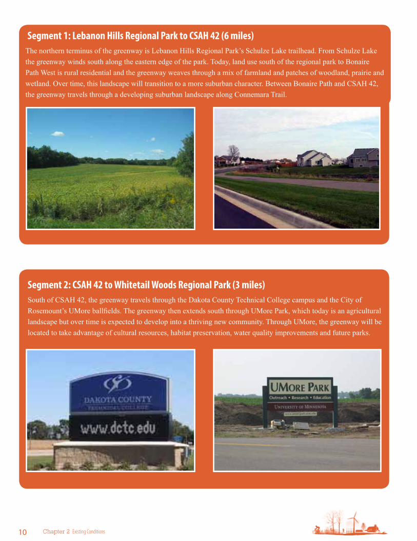
segment 2: csAH 42 to Whitetail Woods regional Park (3 miles)South of CSAH 42, the greenway travels through the Dakota County Technical College campus and the City of Rosemount’s UMore ballfields. The greenway then extends south through UMore Park, which today is an agricultural landscape but over time is expected to develop into a thriving new community. Through UMore, the greenway will be located to take advantage of cultural resources, habitat preservation, water quality improvements and future parks.
segment 1: Lebanon Hills regional Park to csAH 42 (6 miles)The northern terminus of the greenway is Lebanon Hills Regional Park’s Schulze Lake trailhead. From Schulze Lake the greenway winds south along the eastern edge of the park. Today, land use south of the regional park to Bonaire Path West is rural residential and the greenway weaves through a mix of farmland and patches of woodland, prairie and wetland. Over time, this landscape will transition to a more suburban character. Between Bonaire Path and CSAH 42, the greenway travels through a developing suburban landscape along Connemara Trail.
Vermillion Highlands Greenway Master Plan 2012 11
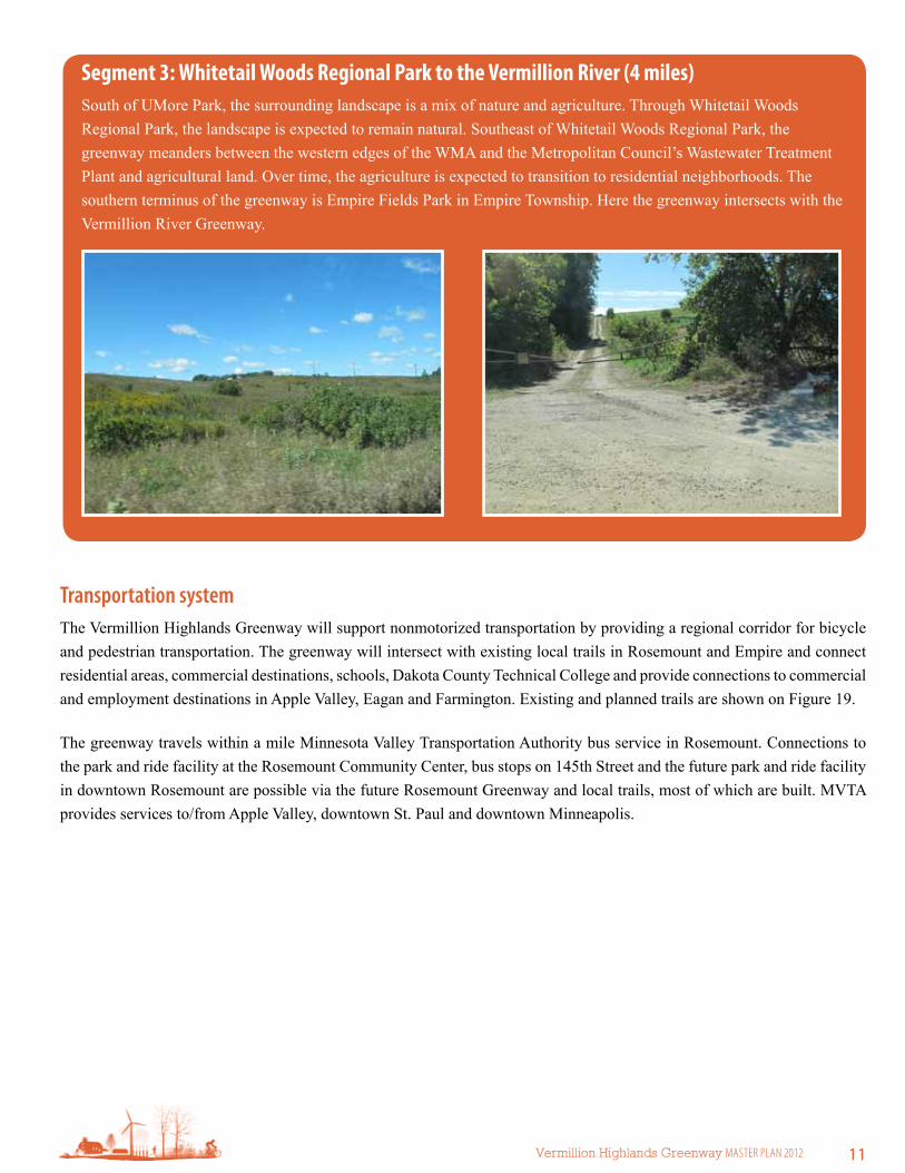
segment 3: Whitetail Woods regional Park to the Vermillion river (4 miles)South of UMore Park, the surrounding landscape is a mix of nature and agriculture. Through Whitetail Woods Regional Park, the landscape is expected to remain natural. Southeast of Whitetail Woods Regional Park, the greenway meanders between the western edges of the WMA and the Metropolitan Council’s Wastewater Treatment Plant and agricultural land. Over time, the agriculture is expected to transition to residential neighborhoods. The southern terminus of the greenway is Empire Fields Park in Empire Township. Here the greenway intersects with the Vermillion River Greenway.
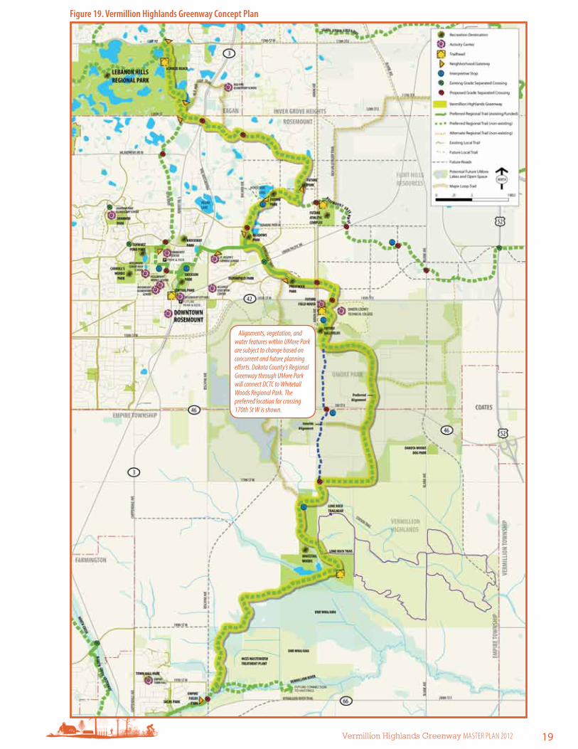
Transportation systemThe Vermillion Highlands Greenway will support nonmotorized transportation by providing a regional corridor for bicycle and pedestrian transportation. The greenway will intersect with existing local trails in Rosemount and Empire and connect residential areas, commercial destinations, schools, Dakota County Technical College and provide connections to commercial and employment destinations in Apple Valley, Eagan and Farmington. Existing and planned trails are shown on Figure 19.
The greenway travels within a mile Minnesota Valley Transportation Authority bus service in Rosemount. Connections to the park and ride facility at the Rosemount Community Center, bus stops on 145th Street and the future park and ride facility in downtown Rosemount are possible via the future Rosemount Greenway and local trails, most of which are built. MVTA provides services to/from Apple Valley, downtown St. Paul and downtown Minneapolis.

12 Chapter 2 existing Conditions
b. Existing Cultural ResourcesHisTOriC OVerVieWEvery place has a unique history with resources with which people have an emotional connection. Within the greenway corridor, there are parks, railroads and important facilities like the former Gopher Ordnance Works that many people associate with the region. Though these resources are not considered historic by state or federal definitions, or simply have yet to be evaluated, they are an important part of the landscape to the people along the greenway corridor. There are other cultural resources recognized by the State Historic Preservation Office within and around the Vermillion Highlands Greenway. Of note, there are many structures associated with the Gopher Ordnance Works and buildings within the older portions of Rosemount. There are few known archaeological sites near the greenway. One known site dates from before European settlement. The area’s rich resources have attracted people for thousands of years: additional sites likely remain undiscovered in the corridor.
The Vermillion Highlands Greenway contains 6 known archaeological sites. More than 10 properties within one mile of the proposed greenway trail alignment are previously inventoried architectural history properties. Most of these are within UMore Park.
Gopher Ordnance WorksThe history of the land once occupied by the Gopher Ordnance Works (GOW) is influential to the Vermillion Highlands Greenway corridor. Before American settlement history, the Mdewakanton band of the Dakotah Indians occupied the land. After two hundred years of exploring, the land was settled by American farmers in the mid-1800s. Wheat farms were the first mainstay of the agriculture, later dairy and vegetable farms supplied the growing Twin Cities with local produce. Eighty-four farm families were evicted from their land by eminent domain in 1942, and the site officially became the “Gopher Ordnance Works,” intended to produce smokeless gunpowder to support the war effort in Europe. After a slow construction start due to wet weather and materials shortages, the plant was never completed. Other ordnance works sites around the country were exceeding their projected outputs, and the GOW was put on hold. In mid-1944, the plant was brought back on line, and three production lines were completed. During 1945, the GOW produced its first and last barrels of smokeless powder as the war came to an end. Soon after, the University of Minnesota acquired most of the property. A technical research center was established, and many cutting edge studies were performed. An agricultural experiment station was used to develop many new technologies for the College of Agriculture. As the University developed more educational facilities on its Twin Cities campuses, UMore Park became less used by students and faculty. In the 1970s, the planning of UMore began, and it still continues to this day. Numerous historical, research, and planning studies have been completed for the site over the past 40 years.
View of the Gopher Ordnance Works in the mid 1940s. source: Dakota County Historical society

Vermillion Highlands Greenway Master Plan 2012 13
Figure 13. Known Cultural resources
Former Gopher
Ordnance Works
Historic Downtown Rosemount
Vermillion River

14 Chapter 2 existing Conditions
c. Existing Natural ResourcesThe natural resources in the area surrounding the Vermillion Highlands Greenway consist of patches of woodland, wetland and prairie. The greenway is anchored by two large natural areas: Lebanon Hills Regional Park and the complex consisting of the Whitetail Woods Regional Park, Vermillion Highlands, and Vermillion River AMA and mWMA.
VeGeTATiVe COVer – MiNNesOTA lAND COVer ClAssiFiCATiON sYsTeM (MlCCs)According to Minnesota Department of Natural Resources’ Land Cover Classification System, a majority of land cover along Vermillion Highlands Greenway is cultivated or grassland. Lebanon Hills Regional Park is a diverse preserve of prairie, shrubland, woodland and wetland. East of the park is a large oak woodland, known as McMenomy Woods. There are scattered patches of herbaceous vegetation along the corridor, with a large expanse in Whitetail Woods Regional Park. The Vermillion River floodplain has extensive wetlands along with upland areas in the adjoining Vermillion River AMA and mWMA and Vermillion Highlands (Figure 15).
WATer resOurCes Water resources in the northern portion of the greenway consist of scattered wetlands and open water. South of CSAH 46, there are wetlands, ponds and intermittent and perennial streams and ditches. Many of these have been altered over time. There is a large, high quality, wetland complex within the Vermillion River AMA and mWMA. The Vermillion River is a designated trout stream. Stormwater runoff impacts that cause hydrologic changes, increase sedimentation and thermal impacts are all key stressors to this system.
eCOlOGiCAl QuAliTYWith the exception of areas in Lebanon Hills Regional Park, McMenomy Woods, and a large wetland complex in Vermillion River AMA and mWMA, most of the land surrounding the greenway corridor has been altered or disturbed. Areas that are identified as high biological diversity areas and native plant communities by the Minnesota County Biological Survey are combined with areas identified as high quality plant communities by the Minnesota Land Cover Classification System (MLCCS) to form the high ecological quality layer in Figure 15. Areas identified as moderate condition plant communities by the MLCCS are shown as moderate ecological condition.
Ecological impacts
A significant ecological impact to the landscape within the greenway corridor has been conversion of native forest and prairie landscapes and draining of natural wetland complexes for agricultural and urban land uses. Interruption of disturbance regimes (fire), invasive species colonization, habitat fragmentation and agricultural runoff have contributed a landscape with low ecological quality.
UMore Park was home to Gopher Ordnance Works, a World War II munitions plant. This area has a variety of known and unknown contamination issues. The University of Minnesota is continuing to study and address contamination issues.
The area between CSAH 42 and the Vermillion River is rich in aggregate resources; much of this area will be mined. While this will result in a significant ecological impact, it also will present opportunities for ecological restoration after mining is complete.

Vermillion Highlands Greenway Master Plan 2012 15
Figure 15. existing Natural resources (MlCCs & MCBs)
existing Natural resources Map sources: Forest /
Woodland – Minnesota land Cover Classification system
(MlCCs); Prairie / Herbaceous – MlCCs; shrubland – MlCCs; Wetland – nWI; Open Water / streams – MlCCs and Dakota
County; trout stream – Dakota County GIs (Vermillion WWIa
Waterways); trout stream tributary – Dakota County GIs
(Vermillion WWIa Waterways); High ecological condition –
Minnesota County Biological survey (MCBs) high biological
diversity areas and native plant communities combined
with MlCCs high quality plant communities; Moderate ecological condition – MlCCs
moderate condition plant communities

16 Chapter 2 existing Conditions
This page intentionally blank

Vermillion Highlands Greenway Master Plan 2012 17
The Plan 3
OverviewThe Vermillion Highlands Greenway will be a regional destination trail linking Lebanon Hills Regional Park to Whitetail Woods Regional Park and Vermillion River via the planned development at UMore Park. The greenway, like all Dakota County greenways, will integrate recreation, transportation, water quality and habitat. This chapter describes what features will be included in the greenway and the projects needed to realize the greenway.
The plan chapter is presented in four sections:
f A. Development — Outlines the defining recreation and transportation features of the greenway.
f B. Key initiatives — Describes specific development and natural resource projects for each greenway segment.
f C. The interpretive plan — Identifies interpretive themes and subthemes for the greenway and provides a framework for cultural and environmental interpretive elements.
f D. The stewardship plan — Addresses habitat stewardship and water resources.
DesiGN FrAMeWOrKThe Greenway Guidebook provides the framework for this master plan:
f Regional trail for recreation and transportation that follows water and natural features
f Is a year-round facility
f Provides frequent trailheads and access points
f Grade-separated crossings of major roads
f Has a consistent design with natural signature and high quality support facilities
f Has lighting for evening use in appropriate locations
f Links recreation destinations and activity centers
f Acts as a spine for loop trails
f Maximizes borrowed views
f Uses wayfinding as a systemwide unifying element
f Universally accessible
f Incorporates sustainability by using recycled materials, energy efficient lighting and providing nonmotorized transportation options

18 Chapter 3 the Plan
a. DevelopmentAccess to recreation is one of the four foundational elements of Dakota County greenways. The primary recreation feature of the greenway is a continuous regional destination trail for nature-based recreation and nonmotorized transportation.
While the greenway varies in width from 100 feet to more than 300 feet throughout the corridor, this chapter focuses on the design of the 30-foot trail corridor to create a safe, amenity-rich trail for year-round use.
TrAil COrriDOr FeATures AND DesiGNThis section addresses design features that are signatures of Dakota County’s greenway system. Design touches many facets of the trail alignment, including: the relationship of the trail alignment to the larger greenway corridor; the ability to connect destinations; the presence and location of grade-separated crossings, trailheads and support facilities; the style and location of furnishings and wayfinding; accessibility; and sustainability. Consistent, high-quality design will elevate the greenway experience above that of a utilitarian trail to a first-class regional destination.
TrAil COrriDOrThe regional trail within the greenway corridor will be a continuous multipurpose bituminous trail designed in accordance with applicable American Association of State Highway Transportation Officials guidelines, Mn/DOT bicycle design guidelines and Dakota County trail standards. The trail will be 10 to 12 feet wide with a 3-foot grass clear zone on each side. Anticipated uses include walking, jogging, inline skating and bicycling. The trail will be maintained for winter use and, where appropriate, lighted.
80/20 trail alignmentThe goal of the greenway trail alignment is to be at least 80 percent off-road with a maximum of 20 percent parallel to roads in all sections. In sections where a regional trail already exists parallel to roads, efforts will be made to ensure an enjoyable greenway experience through landscaping and amenities.
10-12’ trail 15’ wayside rest
(periodic)
habitat preservation3’ mowed edge
Figure 18. Typical Trail Corridor section
Vermillion Highlands Greenway Master Plan 2012 19
Figure 19. Vermillion Highlands Greenway Concept Plan
Alignments, vegetation, and water features within UMore Park are subject to change based on concurrent and future planning efforts. Dakota County’s Regional Greenway through UMore Park will connect DCTC to Whitetail Woods Regional Park. The preferred location for crossing 170th St W is shown.
20 Chapter 3 the Plan
Adjacent Road Off-StreetSegment 1 20% 80%Segment 2 100%Segment 3 100%Vermillion Highlands Greenway 9.5% 90.5%
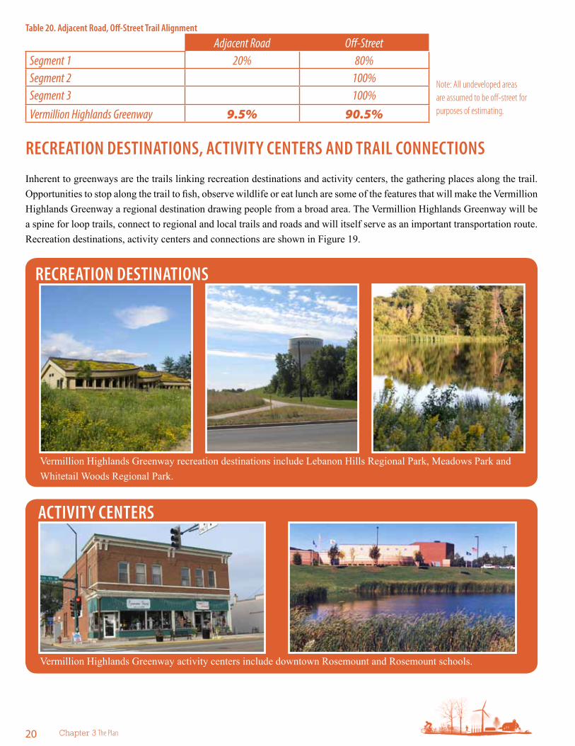
reCreATiON DesTiNATiONs, ACTiViTY CeNTers AND TrAil CONNeCTiONsInherent to greenways are the trails linking recreation destinations and activity centers, the gathering places along the trail. Opportunities to stop along the trail to fish, observe wildlife or eat lunch are some of the features that will make the Vermillion Highlands Greenway a regional destination drawing people from a broad area. The Vermillion Highlands Greenway will be a spine for loop trails, connect to regional and local trails and roads and will itself serve as an important transportation route. Recreation destinations, activity centers and connections are shown in Figure 19.
reCreATiON DesTiNATiONs
Vermillion Highlands Greenway recreation destinations include Lebanon Hills Regional Park, Meadows Park and Whitetail Woods Regional Park.
ACTiViTY CeNTers
Vermillion Highlands Greenway activity centers include downtown Rosemount and Rosemount schools.
Table 20. Adjacent road, Off-street Trail Alignment
note: all undeveloped areas are assumed to be off-street for purposes of estimating.

Vermillion Highlands Greenway Master Plan 2012 21
TrAilHeADs AND NeiGHBOrHOOD GATeWAYsFrequent access is a priority for the Vermillion Highlands Greenway. Two generalized types of greenway and trail access points are recommended: trailheads are intended for regional and local access, neighborhood gateways primarily are for local access at opportune locations. Typically, access points will be at recreation destinations, activity centers and trail intersections. Here trail users will find support facilities such as water and restrooms as well as greenway information.
TrAilHeADs NeiGHBOrHOOD GATeWAYs
Trailheads are the primary greenway access points and will serve people who drive, walk, bike or take transit to the greenway. They will occur every 3 to 5 miles and share facilities such as parking and restrooms with other facilities.
Trailheads will include:
f Water
f Motor vehicle parking
f Secure bicycle parking
f Picnic areas and/or facilities
f Wayfinding and traffic control
f Restrooms
f Interpretation
f Benches
f Food where opportune
f Shelter and shade
f Local and/or regional trail connections
Neighborhood Gateways are more frequent, local access points. They will be at convenient intervals between primary trailheads (2-3 miles or closer at logical locations). Wherever possible, facilities are shared with other uses and ideally are located where there is a complementary recreation destination or activity center.
Neighborhood gateways will include the following elements:
f Benches
f Local and/or regional trail connections
f Wayfinding and traffic control
f Interpretation
Neighborhood gateways may also include as shared facilities:
f Restrooms
f Picnicking
f Food
f Secure bicycle parking
f Motor vehicle parking
f Water

22 Chapter 3 the Plan
rOAD AND rAilrOAD CrOssiNGsGrade-separated crossings are a critical component of Dakota County’s greenway trail system. Grade separation promotes safety by reducing conflicts with motorized traffic and allows for more efficient and enjoyable trail experience for users of all abilities. To that end, grade separated crossings are suggested at all major road crossings, shown in Figure 23 and discussed in Table 22. The regional trail alignment also crosses the Eagan Spur rail line and the Union Pacific Railroad. To avoid conflicts with the railroad, grade separated railroad crossings are recommended as shown on Figure 23.
Grade separations on the greenway system should be of the highest quality possible to ensure safety.
Grade-separated crossings were evaluated at potential locations along the Vermillion Highlands Greenway. The evaluation is based on known topography and utility information. For the purposes of the evaluation, it was assumed that an underpass would be a 10-foot by 14-foot box culver. The concept level cost estimates include grading, retaining walls, traffic control, turf establishment/erosion control and mobilization. Engineering, administrative costs and contingencies are included in the estimate. Overall system drainage costs are not. In some instances, grade separation will not be desirable due to excessive cost or physical constraints.
NuMBer lOCATiON reCOMMeNDATiON
iMPOrTANCe FOr user sAFeTY AND eXPerieNCe
COsT
1robert Trail s (TH 3) south side of 120th st W
notes: locate underpass under both road and rail line. underpass Medium $600,000
2 Bacardi Ave. south of 120th st W underpass Medium $500,000
3
Bonaire Path (approximately 200’ east of Bacardi Ave.)
notes: Crossing must be positioned between the petroleum pipelines and gas pipeline. there are also nearby wetlands. Due to constraints, site may need significant retaining walls.
underpass High $750,000
4 Akron Ave (CsAH 73), north of CsAH 42 underpass High $500,000
5
145th st e (CsAH 42), east of Akron Ave.
Notes: Metro main sewer line runs parallel to 145th St. here. Underpass should be 1/8 to ¼ mile east of Akron Ave. to avoid utilities. Some retaining walls may be needed.
underpass High $830,000
6 169th st e (CsAH 46), east/west location TBD underpass Medium $600,000
7 170th st W, north of station Trail underpass low $540,000
8 Biscayne Ave. at empire Fields Park underpass Medium $600,000
Table 22. Grade-separated Crossings

Vermillion Highlands Greenway Master Plan 2012 23
GrADe-sePArATeD CrOssiNGs
underpass
source: HKGi
Figure 23. Grade-separated Crossings
NuMBer lOCATiON reCOMMeNDATiON
iMPOrTANCe FOr user sAFeTY AND eXPerieNCe
COsT
1robert Trail s (TH 3) south side of 120th st W
notes: locate underpass under both road and rail line. underpass Medium $600,000
2 Bacardi Ave. south of 120th st W underpass Medium $500,000
3
Bonaire Path (approximately 200’ east of Bacardi Ave.)
notes: Crossing must be positioned between the petroleum pipelines and gas pipeline. there are also nearby wetlands. Due to constraints, site may need significant retaining walls.
underpass High $750,000
4 Akron Ave (CsAH 73), north of CsAH 42 underpass High $500,000
5
145th st e (CsAH 42), east of Akron Ave.
Notes: Metro main sewer line runs parallel to 145th St. here. Underpass should be 1/8 to ¼ mile east of Akron Ave. to avoid utilities. Some retaining walls may be needed.
underpass High $830,000
6 169th st e (CsAH 46), east/west location TBD underpass Medium $600,000
7 170th st W, north of station Trail underpass low $540,000
8 Biscayne Ave. at empire Fields Park underpass Medium $600,000

24 Chapter 3 the Plan
Figure 24. Typical At-grade, Midblock road Crossing with Median refugeAt-grade crossings
When grade separated crossings are not possible, crossing should occur at controlled intersections with road users stopping at traffic lights or stop signs. Midblock crossings may be appropriate in certain places and should be designed with pedestrian/cyclist safety in mind as illustrated in Figure 24. On lower volume local roads, crossings may be uncontrolled. In these cases, features such as pavement marking, refuge islands and bumpouts should be applied to reduce crossing distances for trail users and increase visibility.
ACCessiBiliTYDakota County is committed to offering universal accessibility at all trail facilities. The primary paved trail and all access points suggested in the master plan are located and planned for universal accessibility to provide all visitors with a meaningful experience.
susTAiNABiliTYEcological sustainability is at the core of the greenway concept. Improving ecological function, habitat creation, wildlife movement, stormwater infiltration and carbon sequestration as well as facilitating nonmotorized recreation and transportation all are greenway objectives.
Greenways will be assembled in environmentally sustainable ways and designed to minimize impact on natural systems. Recommended strategies include:
f Protecting and restoring natural systems
f Emphasizing native plant species
f Reducing maintenance costs by promoting self-sustaining wildlife and plant communities, treating stormwater on-site
f Use recycled materials and pervious pavement
f Maintaining (especially sealcoating) the trail with minimal runoff contamination in accordance with MPCA guidelines to minimize impacts to the Vermillion River.
f Energy-efficient lighting and use of timed lighting

Vermillion Highlands Greenway Master Plan 2012 25
liGHTiNGLighting is an essential component for safety and to make the greenway functional as a transportation corridor in the winter and fall when the days are short. For safety and navigation, lighting is paramount at all greenway access points, trailheads, neighborhood gateways and trail connections. In these places, it is recommended that lighting be incorporated into initial design and construction. In areas with potential for high use because of population density, trail connections and destinations, it is recommended that continuous trail lighting be installed. Figure 25 shows priority lighting areas.
Figure 25. lighting Plan

26 Chapter 3 the Plan
siTe FurNisHiNGsOne of the key features of the greenway system is having a consistent design signature for site furnishings. To the right are a few images that show the desired character of facilities at trailheads, neighborhood gateways and other resting areas along the greenway.
WAYFiNDiNGWayfinding is the way people navigate from place to place. For the Dakota County greenway system a consistent wayfinding system is essential for orientation, navigation and safety. Signage should be consistent across the system and should guide greenway users to local services, cultural destinations, transportation connections, activity centers, recreation destinations, cities, neighborhoods and other landmarks. Further guidance on wayfinding is found in the Dakota County Safety, Information, Guidance and Network document.
Figure 26. Wayfinding examples (illustrative only; actual signage will follow Dakota County signage guidelines)
site Furnishings Examples

Vermillion Highlands Greenway Master Plan 2012 27
Figure 27. Vermillion Highlands regional Greenway Trail Alignments and segments
seGMeNT 1
seGMeNT 2
seGMeNT 3
b. Key initiativesTrAil AliGNMeNTThis section summarizes, by segment, specific development and natural resource projects and issues. A zoomed-in view of the greenway map is provided for each segment with a summary of features and discussion of initiatives needed to complete the greenway.
site Furnishings Examples

28 Chapter 3 the Plan
segment 1: lebanon Hills regional Park to Dakota County Technical College (DCTC) (6 miles; 20% on-road, 80% off-road)
The Vermillion Highlands Greenway begins in Lebanon Hills Regional Park at the Schulze Lake trailhead. From there the greenway travels south, through the park exiting at the current equestrian trailhead near 120th Street. From there the greenway heads east across Trunk Highway 3 and the Eagan rail spur through agricultural and large-lot residential land toward the southeast. Near Horseshoe Lake, the greenway intersects with the Rosemount Greenway and travels south to Meadows Park. The greenway is along Connemara Trail to Akron Avenue. East of Akron Avenue the greenway winds around a future commercial area before crossing south under 145th Street/CSAH 42 to Dakota County Technical College.
Lebanon Hills Regional Park / Schulze Beach trailheadThe existing Schulze Lake Trailhead will act as the trailhead for the Vermillion Highlands Greenway. Support facilities currently located in the Lebanon Hills Visitor Center (parking, water, restrooms, picnicking) will be shared.
Horseshoe Lake areaNeighborhood parks are envisioned at Horseshoe Lake and the large wetland to the east. These gateways are near the intersection of the Vermillion Highlands and Rosemount Greenway. As this area is currently undeveloped, the parks and greenway will be planned in conjunction with the future neighborhood.
Meadows Park, Connemara Trail and Prestwick Park South of Bonaire Path, the greenway trail will be mostly parallel to roads. At Meadows Park and Prestwick Park, the greenway will wind through the parks.
Lebanon Hills regional Park to dctc
Recreation destinationsA. Lebanon Hills Regional Park
B. Future neighborhood park at wetland
C. Future neighborhood park at Horseshoe Lake
D. Meadows Park
E. Prestwick Park
Activity CentersF. Red Pine Elementary School
G. Dakota County Technical College
TrailheadsA. Lebanon Hills Regional Park — Schulze Beach
H. Future Athletic Complex on Akron Avenue
Neighborhood gatewaysJ. Lebanon Hills Regional Park (3)
C. Horseshoe Lake and wetland park
D. Meadows Park
E. Prestwick Park
Loop and connecting trailsL. Connections to Lebanon Hills Regional Park trails
M. Connections to Rosemount Greenway on Dodd Boulevard
N. Connections to Rosemount Greenway trail east of Horseshoe Lake
O. Connections to trails on Bonaire Path and Connemara Trail
Grade-separated crossingsP. TH 3 / Eagan rail spur
Q. Bacardi Avenue
R. Bonaire Path
S. Akron Avenue
T. 145th Street East / CSAH 42

Vermillion Highlands Greenway Master Plan 2012 29
Figure 29. Vermillion Highlands segment 1 Concept Plan
A
B
C
D
E
F
GT
H
J
J
J
Q
R
S
O
O
P
N
L
M
Rose
mounT
Reg
ional g
Reenway

30 Chapter 3 the Plan
Figure 30. red Pine elementary school Detail Area
Lebanon Hills Regional Park
Red Pine Elementary School
Schulze Beach trailhead
Gateway
Gateway
Schulze Lake
ROBERT
TRAIL
S
DODD
BLV
D
Connection to downtown Rosemount
3
Trail connection
Wayfinding element
Proposed grade separated crossingExisting grade separated crossing
Gateway
Existing greenway trail
Existing local trailProposed greenway Trail
Proposed local trailConnection trail
Greenway corridor
120TH ST
Proposed Rosemount Greenway trail
Red Pine Elementary SchoolA local trail loop connecting the greenway to Red Pine Elementary will encourage walking to school.

Vermillion Highlands Greenway Master Plan 2012 31
Figure 31. Vermillion Highlands — rosemount Greenways intersection diagram
Future single Family
residential neighborhood
Future single family
residential neighborhood
Connection to Lebanon Hills Regional Park
Connection to downtown Rosemount
Meadows Park
Trailhead
Potential loop trail
Horseshoe Lake
Future park
Future park
Future athletic
complex
wetland
BONAIRE PATH W
AK
RO
N A
VE
BA
CA
RD
I AV
E W
Proposed Vermillion Highlands
Greenway trail
Proposed future road alignment
Proposed future road alignment
Proposed Rosemount Greenway trail
Natural resources and water quality f Long-term management and restoration is recommended to establish and retain the native plant community at the
Lebanon Hills trailhead and gateways.
f A natural signature (primarily oak savanna) will be established throughout the corridor.
f Stormwater will be managed and infiltrated on site as much as possible. Wetland and lake buffers will be required.
f Long-term maintain the native plant community at Meadows Park.
f Establishment of small prairie/savanna area in Prestwick Park
f Restoration of natural habitat and management of invasive species in the Horseshoe Lake area
Gateway
Gateway
Trail connection
Wayfinding element
Proposed grade separated crossingExisting grade separated crossing
Gateway
Existing greenway trail
Existing local trailProposed greenway Trail
Proposed local trailConnection trail
Greenway corridor
32 Chapter 3 the Plan
dctc to Whitetail Woods regional Park
Recreation destinationsA. Future ballfields at DCTC
B. Future neighborhood / community parks in UMore Park
C. Whitetail Woods Regional Park in Empire Township
Activity CentersD. Dakota County Technical College (DCTC)
E. Future field huse at DCTC
TrailheadsF. DCTC
Neighborhood gatewaysB. Future neighborhood parks in UMore Park
Loop and connecting trailsG. Loop trail around DCTC
J. Loop trails throughout UMore
Grade-separated crossingsK. 160th Street / CSAH 46
L. 170th Street
segment 2: DCTC to Whitetail Woods regional Park (3 miles; 100% off-road)This segment links Rosemount to DCTC through UMore Park to Whitetail Woods Regional Park. A significant amount of planning has been completed for the future of UMore Park, but implementation is still far into the future.
DCTC trailhead Currently, new ballfields are under construction on both the east and west sides of the DCTC campus. A future fieldhouse may be located at the southeast corner of Akron Avenue and 145th Street. The trailhead will be located on the west side of DCTC at either the new fieldhouse or the new ballpark. Parking and restrooms will be located at both sites, providing the opportunity for facility sharing. Bike parking, water and picnic tables will also be provided at both sites.
Future development in UMore ParkIn UMore Park, long-term, the University of Minnesota envisions a master planned community for 25,000 to 30,000 people. The concept master plan from the 2008 University of Minnesota’s New Sustainable Community at UMore Park is shown in Figure 34. The plan envisions a diverse community with a range of single and multifamily dwellings, significant open space and natural amenities, neighborhood commercial and retail, office and light industrial space, recreation and relaxation, energy efficiencies and emphases on education, health and sustainability.
It is anticipated that the Vermillion Highlands Greenway will be built prior to UMore Park development. In the near term, an alignment linking Dakota County Technical College to Whitetail Woods Regional Park, preferably along the current Akron Avenue alignment is desired. A grade separated crossing of 170th Street west in the approximate location shown on Figure 33 is needed to create a direct link to Whitetail Woods Regional Park.
In the mid-term, the Regional Greenway should be coordinated with evolving plans for the trail and open space network in UMore Park. The regional trail alignment must balance:
f Connections to the U of M Research Station
f Direct connections between Dakota County Technical College and Whitetail Woods Park
f An alignment away from roads 80 percent of the total length
f Linking future recreation destinations and potential activity centers in UMore Park
f Cultural interpretation opportunities (T-walls)
f Opportunities to link existing natural resources
f Opportunities for water quality enhancement

Vermillion Highlands Greenway Master Plan 2012 33
Figure 33. Vermillion Highlands Greenway segment 2 Concept Plan
A
B
B
B
C
D
E
F
G
JJ
Q
K
L

34 Chapter 3 the Plan
Figure 34. uMore Park Concept Master Plan (October 2008)
2Concept Master Plan Summary | October 2008
Concept Master Plan
CR 42
LegendSingle Family Residential (small lot)Single Family Residential (large lot)Single Family Residential (attached)Multi Family Residential Mixed-UseCommercial/RetailCommercial/OfficeLight Industrial/Office
Civic/Institutional/EducationParks and ParkwaysOpen Space
Water
WetlandsForest
VERMILLION HIGHLANDS
Highest Intensity Use
Moderate Intensity Use
Low Intensity Use
* The shades of color on the Vermillion Highlands indi-cates intensity of use, with lowest intensity being lightest uses of all kinds to preserve the environmental character of the land and allow for habitat restoration.
Concept Master Plan
Vermillion HighlandsA Research, Recreation and Wildlife Management Area
2,822 Acres
The Concept Master Plan offers guidelines for development over 25 to 30 years while accommodating flexibility for new opportunities and innovation. The plan is anchored by the University research and education that will add value to the community and the surrounding region.
In keeping with Dakota County greenway design standards, grade-separated crossings should be incorporated into future road/greenway design for all arterial roads. Where there are opportunities, grade separation for collector roads is also desired for a seamless greenway experience. The alignment shown on in this plan is subject to change based on continued UMore Park planning.
Long-term, (50+ years) it is envisioned the greenway will be incorporated into the UMore Park recreation and open space network with opportunities for loop trails. The regional trail alignment may shift east to take advantage of future lakes and other natural amenities created after planned gravel mining is complete.
Natural resources and water quality f A natural signature (primarily oak savanna) will be established throughout the corridor.
f Water infiltration will be integrated into the greenway corridor
Vermillion Highlands Greenway Master Plan 2012 35
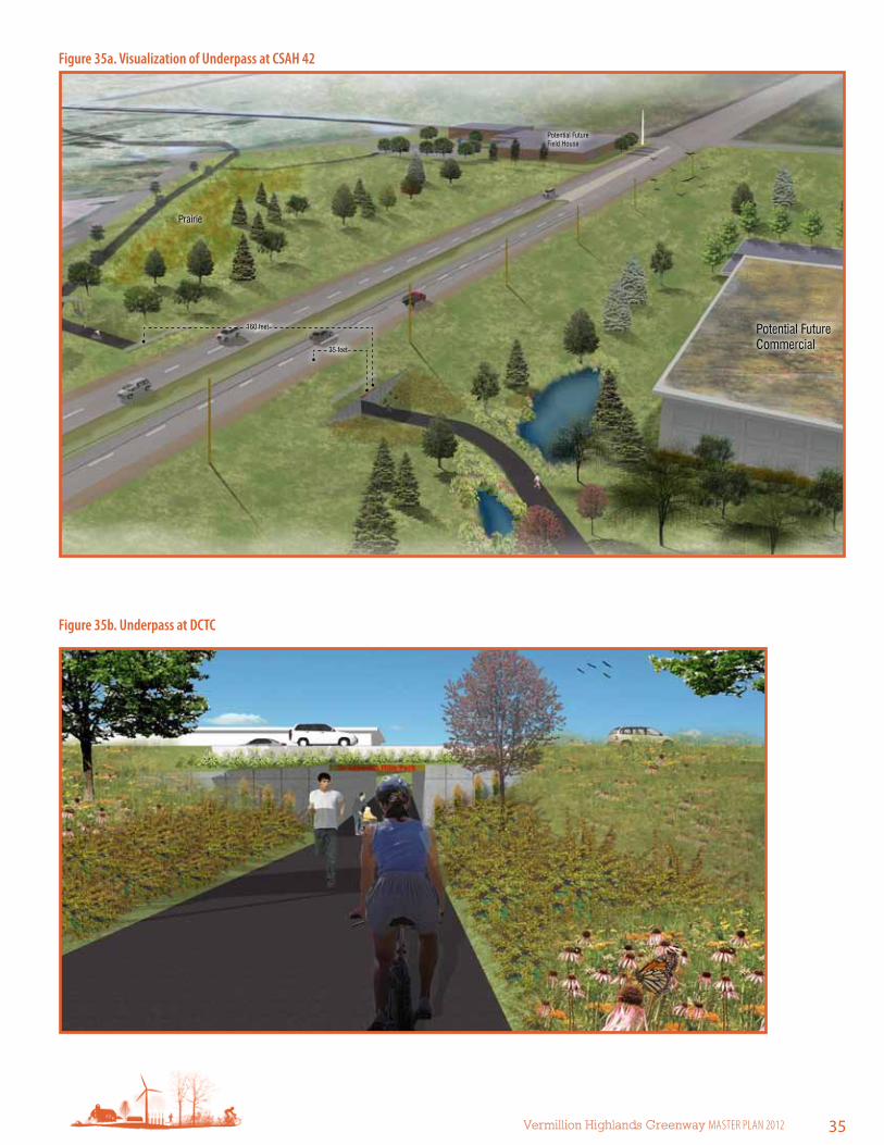
35 feet
160 feet
Potential Future Field House
Prairie
Potential Future Commercial
Figure 35a. Visualization of underpass at CsAH 42
Figure 35b. underpass at DCTC

36 Chapter 3 the Plan
Figure 36. Dakota County Technical College Area Diagram
Future commercial
Future single-family
residential
Connection to UMore Park south and Vermillion River
Connection to Lebanon Hills Regional Park
Dakota County
Technical College
Police driving facilityFuture
medium density
residential
Future ballfields
New ballfield
Potential future
fieldhouse
Future neighborhood
center
(mixed use)
Future stormwater opportunities (manage
with redevelopment)
Trailhead opportunity — share restrooms
and concessions with ballfields
Soccer fields
Prairie
COUNTY 42
AK
RO
N A
VE
AU
DR
EY A
VE
Proposed greenway trail
Potential loop trail (1.75 miles)
Proposed grade-separated crossing under CSAH 42
Legend
Trail connection
Wayfinding element
Proposed grade separated crossingExisting grade separated crossing
Existing greenway trail
Existing local trailProposed greenway trail
Proposed local trailConnection trail
Greenway corridor
Currently, new ballfields are under construction on both the east and west sides of the DCTC campus. A future fieldhouse may be located at the southeast corner of Akron Avenue and CSAH 42. The trailhead will be on the west side of DCTC at either the new fieldhouse or the new ballpark. Parking and restrooms will be located at both sites, providing the opportunity for facility sharing. Bike parking, water and picnic tables will also be provided at both sites.

Vermillion Highlands Greenway Master Plan 2012 37
Whitetail Woods regional Park to Vermillion river
Recreation destinationsA. Whitetail Woods Regional Park
B. Empire Fields park
TrailheadsA. Whitetail Woods Regional Park
B. Empire Fields park
Loop and connecting trailsC. Lone Rock Trail in Vermillion Highlands
D. Hiking trails in Whitetail Woods Regional Park
E. North Creek Greenway (future)
F. Vermillion River Greenway (future)
Grade-separated crossingsG. 170th Street West, just north of Station Trail
H. Biscayne Avenue north of Empire Fields Park
segment 3: Whitetail Woods regional Park to Vermillion river (4 miles; 100% off-road)This segment of the greenway travels through and along the largest continuous natural landscape in the area. Whitetail Woods Regional Park is adjacent to and will be managed in cooperation with Vermillion Highlands and the Vermillion River Wildlife Management and Aquatic Management Areas.
Natural resources and water quality f Coordinate with the Vermillion Highlands and DNR to maintain high
quality habitat and natural plant communities
f Maintain native plant communities and wetlands through prescribed burns and restoration of damaged environments
f Manage invasive species
Figure 37. Greenway at Metropolitan Council environmental services
30 ft wide trail corridor 500 ft wide native habitat buffer from MCES Wastewater Treatment Plant(no public access)
MCES Wastewater
Treatment Plant

38 Chapter 3 the Plan
Figure 38. Vermillion Highlands Greenway segment 3 Concept Plan
A
B
C
D
E
F
G
H

Vermillion Highlands Greenway Master Plan 2012 39
Chapter 8: Major Use Areas and Recreation
Whitetail Woods Regional Park Master Plan Page 8-5
Figure 33: Development Master Plan
Figure 39. Whitetail Woods Concept Master Plan. source: Dakota County Office of Planning and Analysis

40 Chapter 3 the Plan
c. Interpretive planOVerVieWIn today’s world, people’s connections to culture, land, nature and community are often detached. We sometimes cannot imagine the prairie before the metropolis, the wheat before the bread, or the world before Columbus. We forget, or never learn, the stories that define the significant places in our lives. Place-based interpretation seeks to “re-story” places, or reveal the connections between social and natural systems distinctive to each site. It is an approach rooted in the belief that people seek to understand the stories of the places they visit.
Dakota County has long been committed to sharing the stories of special places that comprise the county’s parks and trails. Through interpretative programs and exhibits, Dakota County strives to create awareness and appreciation of the county’s history, culture, and environment. As the county expands its greenway system, interpretation for each greenway is a goal for the planning and development process.
Interpretive planning designs educational experiences that support an organization’s vision and mission. The planning process considers the place-specific historical, cultural and natural resources to be interpreted and the demographics and interests of the people who use the site in order to develop relevant messages and media in support of an organization’s mission. In the case of Dakota County, interpretation ought to support Dakota County Park’s mission: to enrich lives by providing high-quality recreation and education opportunities in harmony with natural resource preservation and stewardship.
In the context of the Dakota County greenways, it is important to note that fostering an understanding of the relationships between social and natural systems can lead to environmental stewardship. In other words, helping visitors understand the connections between history, culture and nature is at the core of fostering stewardship of these resources and awareness of the connections between people and nature.
resOurCesIn considering what is special and unique about the Vermillion Highlands Greenway, it is helpful to identify some of the most outstanding resources found along the corridor. These resources create a unique setting, or sense of place, and are places where stories of nature, history, and culture intersect in ways meaningful to visitors.
Historical and cultural resources include the Holz farm in Eagan, the former Gopher Ordnance Works and the University of Minnesota’s Agricultural Experiment Station. Natural resources include Lebanon Hills Regional Park, several small lakes and ponds and the Vermillion River. Some of these cultural, historical and natural resources are on Dakota County property; many are located on adjacent properties. Therefore, continued partnerships with adjacent property owners will be essential to developing interpretation along the greenway.
Cultural, historical and natural resources may be vulnerable and potentially compromised with increased traffic and human interaction if not thoughtfully managed. Resources such as un-excavated archaeological sites are culturally sensitive and susceptible to looting or vandalism if care is not taken to protect them. Interpretation of these resources should be sensitive to these potential impacts and Dakota County should work with stakeholders, such as Minnesota Indian Affairs Council (MIAC) for burials, to determine an appropriate approach to both preservation and interpretation.

Vermillion Highlands Greenway Master Plan 2012 41
KeY MessAGesWhile each greenway in Dakota County’s system will have a theme based on the specific resources associated with the greenway, it is recommended that Dakota County undertake a systemwide interpretive planning effort to identify overarching themes for the greenway system. These overarching themes would represent broader messages that span the system and weave together specific themes for each individual greenway.
In the absence of a systemwide interpretive plan, this master plan suggests one central message, or theme for the greenway corridor. Supporting subthemes are also identified in order to further develop the central theme and provide organization for interpretation.
It is recommended that the subthemes be interwoven throughout the trail to provide both a richly layered and consistent interpretive experience. If a systemwide interpretive plan is developed, the themes presented below should be revisited and revised as necessary.
iNTerPreTiVe THeMeA Renewed Landscape: The land around the Vermillion Highlands Greenway is ever changing, from native prairies, farms and military industry to academic research and new more sustainable communities.
subthemes:Family farming: This urban environment was once a mosaic of family farms; though the landscape has changed, the history of early European settlers should not be forgotten.
Interpretive opportunities:
f History of family farming during early European immigration
f Holz Farm, a living history farm, not far from Lebanon Hills and the north terminus of the greenway

42 Chapter 3 the Plan
History of the UMore site: Many sacrifices were made during World War II, for some families that included a forceful sale of their farmland to the War Department. That land became the Gopher Ordnance Works, a gunpowder manufacturing facility; later the University of Minnesota used the land for agricultural research. Now plans to create a new sustainable community will reshape the site.
Interpretive opportunities:
f Families who were displaced by the construction of the Gopher Ordnance Works (GOW)
f GOW remnants and ruins
f Agricultural research and the impact on our agrarian past and present
Stewardship in action: Efforts to restore and protect the native landscape are taking place along the Vermillion Highlands Greenway. Native landscapes benefit water quality, foster biodiversity, create healthy soils and provide green spaces for recreation.
Interpretive opportunities:
f Habitat restoration efforts
f Stormwater treatment measures
f Identifying the components of natural or restored landscapes » Plants
» Water systems
f Explore ways that restoration of natural landscapes can benefit humans » Soil fertility
» Reduce erosion
» Manage and filter storm water runoff
f Exploring innovative approaches to groundwater in new developments
f Sharing ideas for restoration of natural systems at home
Active living: In addition to these place-based subthemes, it is recommended that interpretation in the Dakota County greenway system encourages visitors to think about active living and the benefits of greenways. Some interpretation could convey what greenways are and how they differ from standard trails. Mile-markers along the trail could also serve as interpretation by linking the distance a visitor has traveled to calories lost. Interpretation could also compare the distance traveled to energy and money saved by cycling or walking rather than driving.

Vermillion Highlands Greenway Master Plan 2012 43
reCOMMeNDATiONs
Prepare a systemwide greenway interpretive plan that: f Establishes guiding principles for interpretation throughout the greenway system
f Evaluates visitor preferences and needs related to interpretation
f Establishes systemwide goals and objectives for interpretation
f Develops systemwide interpretive themes through a process of staff and stakeholder engagement
f Identifies where these systemwide interpretive themes will be expressed
f Identifies interpretive themes for each greenway within the system and establishes a framework for interpretive planning and development
f Establishes consistent design standards for non-personal interpretive media throughout the system
f Identifies appropriate systemwide media for interpretation (e.g., website, geocaching, tours of multiple greenways)
f Assesses current interpretive staffing levels and makes recommendations over the short- and long-term
f Identifies and fosters potential partnerships for interpretive programs within the greenway system
f Develops a framework for ongoing planning and evaluation of interpretation throughout the greenway system
f Follows interpretive planning standards established by the National Association for Interpretation
establish a systemwide approach to managing interpretation and educationRecreation, education and interpretation are not mutually exclusive activities and collaboration and consistency are important across the greenway system.
Build relationshipsBuild relationships with the agencies and organizations that own adjacent property and engage community members and organizations knowledgeable about history and culture (including the Rosemount Historical Society and members from cultural groups such as Native American communities) to ensure that interpretation along the greenway is thematically and aesthetically cohesive.

44 Chapter 3 the Plan
iNTerPreTiVe MeDiA reCOMMeNDATiONs f Interpretive media should not impinge on the natural landscape. As much as possible, Dakota County should adapt the
National Park Service’s Wayside Exhibit (www.nps.gov/hfc/products/waysides) approach and standards established by the National Association for Interpretation to interpretation along the greenways. In this approach, the focus is on experiencing the landscape first-hand; interpretation is an enhancement, not the primary focus.
f Based on this approach, interpretive signs should be minimal, low profile, accessible to all and purposefully placed.
f Interpretation should be integrated into orientation signs at key locations along the greenway (such as trailheads and neighborhood gateways). This interpretation should serve to orient the greenway user thematically to the greenway and introduce the visitor to the experiences they can expect along the greenway. Interpretation at these locations could also be artfully integrated into trailhead or gateway facilities such as benches or picnic tables, pavement, fencing or structures (e.g., restrooms).
f Interpretive nodes should include occasional bumpouts in the greenway at significant or scenic locations with integrated and interactive interpretation.
f Interpretive signs should be considered a caption to distinct or important landscape features that a greenway user may not understand by looking at the feature on its own.
f Dakota County should consider developing multimedia interpretation. Audio tours provide an opportunity for unobtrusive interpretation along the greenway for interested users. Self-guided MP3 tours could be developed and made available on the Dakota County Parks website for download. Initially a greenwaywide audio tour should be developed based on the greenway theme. As staff time and resources allow, additional tours could be developed for the subthemes or for different groups.
f Dakota County should work closely with community partners to ensure that interpretation along the greenway enhances but does not overlap interpretative experience in adjacent or collaborating public spaces.

Vermillion Highlands Greenway Master Plan 2012 45
d. Stewardship planThe linear nature of the greenway will require natural resource management strategies that are geographically targeted, cooperative and realistic. Restoration and protection efforts should be focused near trailheads, as these locations will provide the greatest opportunity for greenway users to see the results of stewardship and provide a high-quality user experience. Given the linear nature of the greenway, stewardship activities should be in cooperation with adjoining landowners, public and private. Cooperative stewardship activities likely will be easier with other public agencies, but this should not preclude the possibilities of stewardship work on adjoining private lands. All stewardship actions should be evaluated through the lens of sustainability — is the stewardship effort economically and ecologically sustainable over the long-term.
HABiTAT iNVesTMeNT AreAsGiven the length of the greenway corridor, efforts to manage and restore the natural resources and native plant communities would be a daunting task — well beyond the ability of any one agency. To provide for a realistic and sustainable restoration and management of the resources, key habitat investment areas are identified for natural resource management. These habitat investment areas are prioritized and targeted to areas associated with high quality ecological resources and greenway use patterns. These areas are identified in Figure 46.
The highest priority landscapes to preserve, protect and enhance for habitat and water quality include woodlands and wetlands in the undeveloped northern part of the greenway and areas within the Whitetail Woods Regional Park and Vermillion River mWMA/AMA in the southern part of the greenway. A few of these large natural areas that are privately owned and could benefit by connecting to the greenway corridor include:
1. Several small wetlands and lakes southeast of Lebanon Hills Regional Park. These waterbodies, including Horseshoe Lake, are remnants of the glacial retreat at the end of the most recent ice age. This area is surrounded by agricultural land and suburban residential development. Future development of these areas should include stormwater best management practices and low impact development standards to preserve the highest quality habitat and ecological functionality.
2. A small patch containing bogs and wetlands just south of the Inver Grove Heights boundary.
As most of the area along the Vermillion Highlands Greenway is undeveloped, tremendous opportunities exist to develop the land while at the same time preserving and enhancing an ecologically functional greenway.
With the application of stormwater best management practices and low impact development standards for development along the greenway, water quality and habitat can be preserved, managed and enhanced.

46 Chapter 3 the Plan
Lebanon Hills Regional Park f Diverse natural landscape of
moraines, lakes and ponds f Forest, prairie, wetland and
water ecosystems f Large natural area
Moderate condition plant community
f Bogs and wetlands f Preserve for wildlife
habitat
DNR WMA/AMA f Large system of moderate
to high quality wetlands f Opportunity for education
along greenway
Vermillion River f Trout stream f Large complex of riverine
wetlands and uplands f Preserve and protect
UMORE Park corridor f Small patches of forest/
woodland and prairie ecosystems exist on the property
f Potential to restore and remediate damaged landscapes along the greenway
Whitetail Woods Regional Park f Forest/Woodland, Shrubland and
Prairie ecosystems f Future agricultural demonstration
plots f Preserve and maintain high and
moderate quality plant communities
Strategic habitat investment would build on existing habitat preserves and where feasible connect them with natural habitat corridors.
Habitat Preserve
Natural Habitat Corridor
Urban Corridor with natural signature
Adjacent natural areas
Rosemount f Moderate quality lakes, wetlands,
forests and prairies exist among cultivated landscape
f Opportunity for protection and preservation as land develops
Figure 46. Habitat investment Areas

Vermillion Highlands Greenway Master Plan 2012 47
sTeWArDsHiP reCOMMeNDATiONsGeneral considerations for stewardship activities within this investment hierarchy are organized around ecological quality, landscape position and future uses and are described in Table 48.
Vegetation managementIn native plant communities — prairie, woodland and wetland — invasive species removal, buffer protection or establishment and re-establishment of disturbance regimes will be the key activities. Oak savanna may need to be supplemented with tree plantings and all of the grassland systems likely will need supplemental seeding.
site-specific actions
Horseshoe Lake:Existing conditions: The land around Horseshoe Lake and the large wetland to the east are currently in agricultural land use. This area is guided to develop as single family residential in the near future. The lake and wetland are / are not currently protected by natural buffers.
Recommendations: As this landscape develops, it is recommended that a minimum 75-foot buffer containing native prairie and wetland plants surround the lake and wetland. Two future parks are planned adjacent to Horseshoe Lake and to the large wetland. This area will be the intersection point of the Rosemount and Vermillion Highlands Greenways and, therefore, a critical place for demonstration of sustainable landscape and stormwater management.
UMore:Existing conditions: The vast landscape of UMore Park currently contains agricultural plots, educational research stations, future mining areas and preserved habitat.
Recommendations: The future of UMore Park is envisioned as a sustainable community of over 25,000 people. As this future is long-term, a significant amount of time exists for plans to be updated and altered. Whatever the current and future uses of UMore Park may be, it will be important to consider one or more greenway features that are at least 300 feet wide, throughout the park. As one of the few remaining undeveloped tracts of land of its size in the Twin Cities Metro Area, UMore Park has a responsibility to preserve and restore natural areas.
Whitetail Woods Regional Park:Existing conditions: Whitetail Woods Regional Park includes wetland, cultivated cropland and rolling hills covered by forests.
Recommendations: Follow the master plan recommendations for the Whitetail Woods Regional Park, including: restoration at the West Overlook Area, Southwest Knoll and Cultivated Area East of Gateway Pine Plantation; protection and maintenance of existing wetlands, conifer plantations and woodlands; and production of agricultural vegetation at the park gateway, disc golf course and lower terrace.

48 Chapter 3 the Plan
surFACe AND GrOuND WATer MANAGeMeNT/PrOTeCTiONThe Vermillion Highlands Greenway is within the Vermillion River watershed, which contains almost 50 miles of designated trout streams. These waters require protection from thermal impacts and changes in hydrology due to stormwater runoff; this runoff can also lead to increased sedimentation and streambank instability. Wetland systems also need to be protected from inputs of untreated stormwater runoff to prevent sedimentation, eutrophication and changes to natural water level fluctuations.
stormwater management options at trailheadsTrailhead parking lots typically are small; 10 to 20 stall lots within green space. This means that stormwater can be directed to drain off the paved surface onto surrounding ground where it can infiltrate. The best place to manage stormwater (regardless of where one is within the corridor) is at the point it runs off a hard surface; i.e. near every street, driveway and parking lot.
Water is a valuable resource that should be used to water plants rather than run off into pipes to a natural water body where it causes problems. Directing stormwater onto the ground rather than into a pipe aids the following important functions:
f Filter pollutants such as phosphorus, grease and oil through plants and soil that mitigate their impacts.
f Protect downstream waterbodies by preventing the influx of large amounts of water. It is best to have water slowly reach a stream or lake underground via subsurface flow.
HABiTAT PreserVe HABiTAT COrriDOr NATurAl lANDsCAPes DesiGNeD lANDsCAPes
Top priority habitat restoration/management
second priority habitat management
lowest landscape investment priority High landscape investment
6 Adequate patch size/shape to sustain plant community
6 Contains existing remnant of native plant community
6 Has interpretive potential
6 Has benign surrounding uses
6 Buffers or contains waters
6 Provides connection between habitat preserves
6 Adequate width to sustain native plant ground layer
6 Grades allow for rainwater infiltration
6 Buffers natural waters
6 Primary task is to control invasive plants
6 Managed as a natural, low-maintenance landscape
6 Managed urban landscapes
6 urban corridor with natural signature
6 Trailheads and gateways
6 limited habitat value
6 relatively small area
Table 48. Habitat investment strategies

Vermillion Highlands Greenway Master Plan 2012 49
f Protect natural water bodies by capturing pollutants at their source.
f Cool stormwater before reaching trout streams.
f Recharge groundwater and eventually aquifers.
f Water trees and other plants at the source allowing for vigorous growth and shaded parking lots.
Opportunities for stormwater managementMany practices are available to manage stormwater at trailheads. Practical stormwater management practices include:
f Creating raingardens alongside parking lots and grade the parking lot to tip in that direction.
f Creating planted depressed parking lot islands to capture stormwater.
f For small parking lots surrounded by green space, running the water onto the surrounding grass (ideally prairie).
f Around parking lots, planting trees to capture and evaporate rainwater on their leaves and create pores in the soil with their roots to allow water to soak in. Trees also shade pavement to keep it cooler in the summer.
f Planting prairie plants around parking lots — they function much like trees (minus the shading). They are especially useful on clay soils, where they drive roots deep and facilitate stormwater infiltration.
f Allow the existing and restored wetlands, prairie and forested landscapes to function as natural areas for infiltration and evapotranspiration.
stream restoration considerationsStream restoration and stabilization should be designed by multidisciplinary teams that include expertise in engineering, hydrology, aquatic and restoration ecology, geomorphology, soil science and policy/permitting.
Each stream project design should follow these guidelines:
f Construct the channel to accommodate current and future processes.
f Maintain bed load movement.
f Restore pools and riffles to the stream.
f Reduce stresses on the banks.
f Provide for floodplain connection.
f Reduce flooding.
f Improve water quality.
All stream restoration/stabilization should have definitive end points that consider:
f Where there is horizontal and vertical control.
f Where the forces of the stream are no longer unstable.
f Where one can successfully design a robust solution to end on (such as a riffle).
Ensuring these guidelines are followed — especially in point or localized segment fixes — will ensure the project does not unravel from upstream or downstream.

50 Chapter 3 the Plan
This page intentionally blank

Vermillion Highlands Greenway Master Plan 2012 51
Implementation & Management
4
OVerVieWThis master plan is a long-range vision for recreation, transportation, water quality and habitat improvements for the Vermillion Highlands Greenway. Accomplishing this vision depends on multi-agency collaboration. Without continued coordination between the communities it is unlikely the greenway could be realized as envisioned. Working corroboratively will enable Dakota County, cities and other agencies to leverage resources to build, operate and maintain the greenway.
While the 30-foot regional trail corridor will be the jurisdictional and operational responsibility of Dakota County, the larger greenway corridor will be governed in many ways, tailored to the situation. Similarly, responsibilities for land acquisition, construction, stewardship, operations and maintenance will depend on the particularities of each segment.
This chapter outlines approaches for greenway implementation, including:
f Phasing and priorities
f Land protection and stewardship
f Operations
f Funding
f Capital and operational budgets
PHAsiNG AND PriOriTiesThe Vermillion Highlands Greenway will be implemented in phases. Greenway segments have been prioritized into first priority projects, second priority projects and long-term projects (Table 52). It is anticipated that first priority projects will be built in advance of second priority projects, but the master plan remains flexible so that any project can be implemented as partnership or funding opportunities arise. Land protection is a first priority the length of the greenway.
f First priority projects are those that are needed to create a continuous, functional greenway experience. It is intended that recreation, water quality, nonmotorized transportation and natural resource elements be integrated into the greenway at the time of initial trail construction.
f Second priority projects will enhance the greenway experience. These are things such as grade separated crossings and trailhead development.
In cases where gaps in the regional trail exist and alternative trail connections can be made on existing trails, interim routes may be designated until the preferred alignment can be assembled.
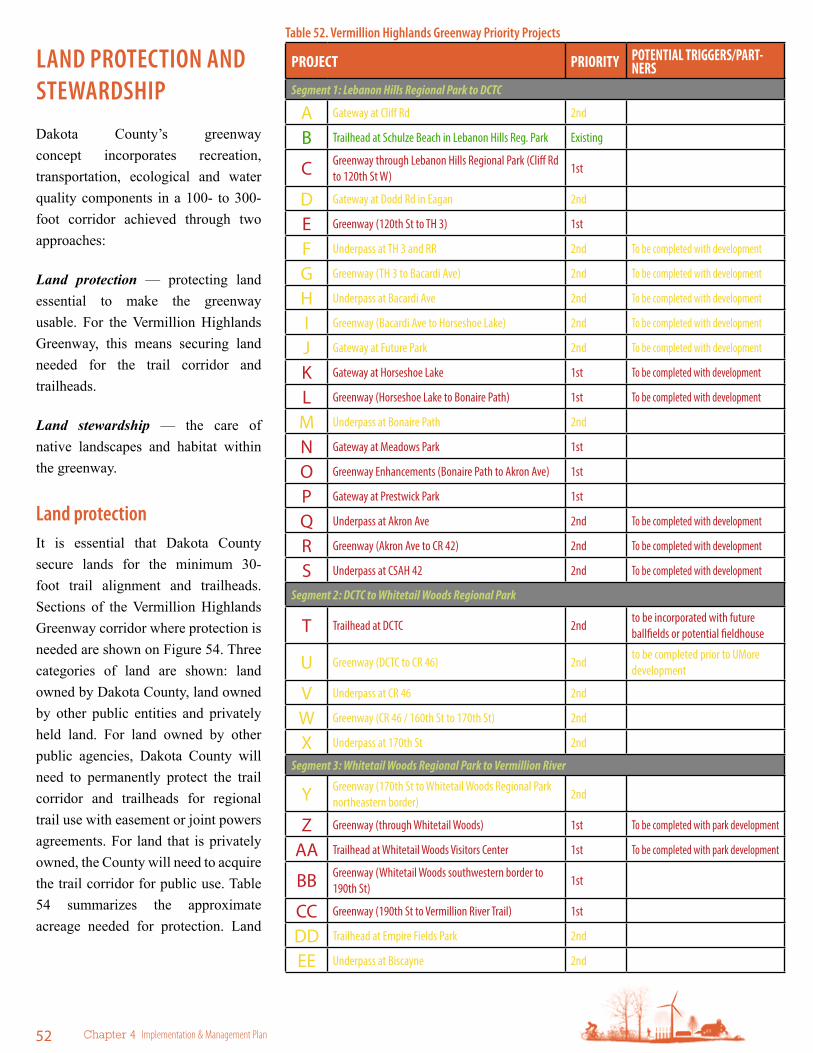
52 Chapter 4 Implementation & Management Plan
ProJEct PrIorItY PotEntIAL trIggErs/PArt-nErs
Segment 1: Lebanon Hills Regional Park to DCTC
a Gateway at Cliff Rd 2nd
B Trailhead at Schulze Beach in Lebanon Hills Reg. Park Existing
C Greenway through Lebanon Hills Regional Park (Cliff Rd to 120th St W)
1st
d Gateway at Dodd Rd in Eagan 2nd
e Greenway (120th St to TH 3) 1st
F Underpass at TH 3 and RR 2nd To be completed with development
G Greenway (TH 3 to Bacardi Ave) 2nd To be completed with development
H Underpass at Bacardi Ave 2nd To be completed with development
I Greenway (Bacardi Ave to Horseshoe Lake) 2nd To be completed with development
J Gateway at Future Park 2nd To be completed with development
K Gateway at Horseshoe Lake 1st To be completed with development
l Greenway (Horseshoe Lake to Bonaire Path) 1st To be completed with development
M Underpass at Bonaire Path 2nd
n Gateway at Meadows Park 1st
o Greenway Enhancements (Bonaire Path to Akron Ave) 1st
P Gateway at Prestwick Park 1st
Q Underpass at Akron Ave 2nd To be completed with development
r Greenway (Akron Ave to CR 42) 2nd To be completed with development
s Underpass at CSAH 42 2nd To be completed with development
Segment 2: DCTC to Whitetail Woods Regional Park
t Trailhead at DCTC 2ndto be incorporated with future ballfields or potential fieldhouse
u Greenway (DCTC to CR 46) 2ndto be completed prior to UMore development
V Underpass at CR 46 2nd
W Greenway (CR 46 / 160th St to 170th St) 2nd
X Underpass at 170th St 2nd
Segment 3: Whitetail Woods Regional Park to Vermillion River
y Greenway (170th St to Whitetail Woods Regional Park northeastern border)
2nd
Z Greenway (through Whitetail Woods) 1st To be completed with park development
aa Trailhead at Whitetail Woods Visitors Center 1st To be completed with park development
BB Greenway (Whitetail Woods southwestern border to 190th St)
1st
CC Greenway (190th St to Vermillion River Trail) 1st
dd Trailhead at Empire Fields Park 2nd
ee Underpass at Biscayne 2nd
Table 52. Vermillion Highlands Greenway Priority Projects
lAND PrOTeCTiON AND sTeWArDsHiPDakota County’s greenway concept incorporates recreation, transportation, ecological and water quality components in a 100- to 300-foot corridor achieved through two approaches:
Land protection — protecting land essential to make the greenway usable. For the Vermillion Highlands Greenway, this means securing land needed for the trail corridor and trailheads.
Land stewardship — the care of native landscapes and habitat within the greenway.
land protectionIt is essential that Dakota County secure lands for the minimum 30-foot trail alignment and trailheads. Sections of the Vermillion Highlands Greenway corridor where protection is needed are shown on Figure 54. Three categories of land are shown: land owned by Dakota County, land owned by other public entities and privately held land. For land owned by other public agencies, Dakota County will need to permanently protect the trail corridor and trailheads for regional trail use with easement or joint powers agreements. For land that is privately owned, the County will need to acquire the trail corridor for public use. Table 54 summarizes the approximate acreage needed for protection. Land

Vermillion Highlands Greenway Master Plan 2012 53
Figure 53. Vermillion Highlands Greenway Priority Projects
aB
C d
eFG
IJ
KlMn
oP
Q rst
V
W
Xy
Z
aa
BB
CC
dd ee
H
Existing
First Priority Project
Second Priority Project
u
protection strategies include: park dedication, direct purchase with resale of land not required for the trail, permanent easements, land donation, bargain sale, life estate and negotiations with cities and developers.
land stewardshipThe natural resource objective for the greenway system is to maintain or create a healthy context within which nature can thrive. The first stewardship priority is restoring continuous habitat within the greenway corridors. The second is habitat restoration and protection of the most sensitive lands, including uplands that link greenways to the broader landscapes. Generally, Dakota County will not be the lead agency in stewardship activities outside the 30-foot trail corridor and trailheads, but will work as steward partners with local jurisdictions, agencies and private landowners and provide funding and expertise.

54 Chapter 4 Implementation & Management Plan
Figure 54. Property Ownership
seGMeNT DAKOTA CO.
PuBliC PriVATe TOTAl
1 4.77 acres 6.42 acres 10.86 acres 22.05 acres
2 -- 9.85 acres -- 9.85 acres
3 5.92 11.29 acres -- 17.21 acres
Table 54. Protection and steward Partnership lands (for 30 foot wide trail corridor)
Segment 1
Segment 2
Segment 3

Vermillion Highlands Greenway Master Plan 2012 55
MANAGeMeNT AND OPerATiONsLike other aspects of the greenway, management and operations will be a collaboration between the County, cities and other partners. Responsibilities will vary by greenway segment. While this master plan defines general responsibilities for each greenway segment, formal joint powers agreements between Dakota County and collaborating agencies will be needed to outline specific agency responsibilities. These agreements will outline who has control of the trail right of way as well as who will operate and maintain the trail and how they will do it.
Management
The Dakota County Parks Department will be the lead agency for coordinating greenway and management operations. The Dakota County Board of Commissioners establishes policies and goals for the park system and through an annual budget provides capital and operating funds for the department. The Planning Commission, appointed by the Board of Commissioners, advises the County on park and recreation trail issues.
General operationsDakota County Parks Department will be responsible for the operation of the 30-foot regional trail corridor. Where there are opportunities for operational partnerships, Dakota County will enter a joint powers agreement with partner agencies. The Parks Department employs a staff of permanent employees and seasonal employees adequate to maintain the system. Volunteers assist with outdoor education programs, patrol, park clean-ups and special events. Contractual agreements also are in place with outside agencies for some maintenance and natural resource work.
Dakota County recognizes that as facilities expand, it will need to increase staffing. Based on operations and maintenance staffing for current Dakota County regional trails, it is anticipated that when the regional trail within the Vermillion Highlands Greenway is complete, an additional 0.5 full time employee park keeper (1,000 hours of labor) and 0.5 seasonal FTE (1,000 hours of labor) will be needed.
Operating hoursThe regional trail through the Vermillion Highlands Greenway will be open 24 hours for transportation purposes. Operating hours for the wider greenway, including trailheads and neighborhood gateways, likely will be sunrise to sunset. Hours may vary and change seasonally based on the type of use and presence of lighting. Dakota County will work with local jurisdictions to reconcile differences between greenway hours and hours of local parks the greenway travels through.
MaintenanceMaintenance of facilities and lands is essential to protect public investment, enhance natural resource quality and achieve the County’s goals of providing recreational users clean, safe, enjoyable year-round experiences. The Dakota County Parks Department has a clearly defined maintenance program and reporting hierarchy led by the manager of park development and maintenance, who reports to the parks director.

56 Chapter 4 Implementation & Management Plan
Regular maintenance for the greenway will include:
f Sign maintenance
f Trash collection
f Sweeping and blowing
f Trail repair
f Bridge repair
f Trailhead facility repair and maintenance
f Mowing
f Tree trimming
f Winter trail clearing
Pavement managementPavement deteriorates as it ages. Regular pavement maintenance can prolong the lifespan of the greenway trail in a cost effective manner. See Table 56 for an outline of recommended activities. Sealcoating will comply with MPCA recommendations to minimize or eliminate runoff contamination and impact on the Vermillion River.
Ordinances
Public use and enjoyment of the County park system is controlled by Ordinance 107, Park Ordinance, which was last revised in 1997. The ordinance incorporates pertinent Minnesota statutes and addresses the following issues:
f Regulation of public use
f Regulation of general conduct
f Regulations pertaining to general parkland operation
f Protection of property, structures and natural resources
f Regulation of recreational activity
f Regulation of motorized vehicles, traffic and parking
enforcement and securityVisitors are informed of park and trail rules and regulations through kiosks and signs that address specific information about hours, trails, permitted and prohibited activities, fees and directions. Dakota County Parks, Lakes and Trails officers will patrol the greenway in motor vehicles, on bicycle and on foot. Officers also will educate visitors and enforce ordinances.
Public awareness
Dakota County’s Parks Department will continue working with the County’s Communications Department to promote the County’s parks and greenway system. Many tools are available to promote parks and greenways, including, but not limited to, websites, direct mail, press releases, brochures, on-site promotion, monument signage along roads, wayfinding within greenways and parks and paid advertising. Dakota County also collaborates with cities, businesses, the Metropolitan Regional
YeAr MAiNTeNANCe ACTiViTY0 Original construction of the paved trail3 seal coating
7 routine maintenance — crack filling, minor patching, minor curb repairs
11 routine maintenance — crack filling, minor patching, minor curb repairs
13 seal coating
18 routine maintenance — crack filling, minor patching, minor curb repairs
21 routine maintenance — crack filling, minor patching, minor curb repairs
25 Total reconstruction
Table 56. Pavement Management Activities

Vermillion Highlands Greenway Master Plan 2012 57
Parks System and others to promote its facilities, programs and services and educate the public about its resources.
ConflictsThe surrounding land uses and the greenway are generally compatible and no conflicts outside of norm affect the viability of master plan recommendations. Minor conflicts will occasionally arise from private encroachment or neighboring residents’ sensitivity to greenway, recreation or maintenance uses. Dakota County will work with individual landowners to resolve these issues case by case.
Public servicesNo significant new public services will be needed to accommodate the greenway. Proposed trailheads and neighborhood gateways are served by the existing road network. If utilities are not accessible at gateways and trailheads, options such as solar-powered lighting, self-composting toilets or wells will be considered. Stormwater will be treated on site. Accommodations for later installation of continuous trail lighting will be considered at initial trail construction.
FuNDiNGFunding for initial capital cost and ongoing operations and maintenance costs is essential for a successful greenway. Funding will be a collaboration among the County, cities, and other agencies, with an emphasis on seeking outside funding such as through federal transportation enhancements grants. Cost share roles will be determined by the strengths of each agency and circumstances of each project. In-kind contributions of land, easement, design, engineering, construction and maintenance and operations are encouraged and will be outlined in joint powers agreements among agencies.
It is anticipated that most future capital projects will be well positioned to secure regional, state and federal funds for recreation, transportation, water, and habitat and that these sources will account for a majority of capital construction costs. In many cases, but not all, Dakota County, as the regional agency, will be in the best position to pursue outside funding. Examples of outside funding sources include:
f National Park Service Rivers, Trails and Conservation Assistance Program Minnesota Department of Transportation
f Minnesota Department of Natural Resources
f Minnesota Pollution Control Agency
f The Environment and Natural Resources Trust Fund
f Clean Water, Land and Legacy Amendment funds
f Watershed management organizations
f Foundations and nonprofits
f Statewide Health Improvement Program or similar
Funding for operating and maintaining the 30-foot regional trail easement and trailheads primarily will be Dakota County’s responsibility. Annual operating costs are funded through the County’s general fund and from regional park allocations from the Metropolitan Council. In situations where there are efficiencies in local jurisdictions performing maintenance and operations, Dakota County will enter a joint powers agreement outlining responsibilities and cost sharing.
YeAr MAiNTeNANCe ACTiViTY0 Original construction of the paved trail3 seal coating
7 routine maintenance — crack filling, minor patching, minor curb repairs
11 routine maintenance — crack filling, minor patching, minor curb repairs
13 seal coating
18 routine maintenance — crack filling, minor patching, minor curb repairs
21 routine maintenance — crack filling, minor patching, minor curb repairs
25 Total reconstruction

58 Chapter 4 Implementation & Management Plan
CAPiTAl AND OPerATiONAl BuDGeTsEstimated costs in 2011 dollars for land protection, development costs and annual operations and maintenance are included in Tables 59 and 63.
Land acquisition costs are included by segment in Table 59. Because land protection strategies might include direct purchase, permanent easements, land donation, bargain sale, life estate and negotiations with cities and developers, it is very difficult to accurately project total acquisition costs. Estimated costs assume land protection of a 30-foot trail corridor on land that is currently privately owned with an average cost of $90 per linear foot.
Table 59 includes budgets for capital investments, the priority of the investment and project partners. The table identifies the full anticipated construction costs of the plan elements. It is not anticipated that Dakota County will be responsible for the full cost of improvements outlined; funding will be a collaboration between the County and partner agencies. Most capital projects also will be well positioned to secure regional, state and federal funds for recreation, transportation, water and habitat.
While the table identifies priorities for capital projects, development will occur as funding becomes available and at the discretion of the Dakota County Board.
Table 63 identifies annual maintenance and operations costs for the 30-foot trail corridor including gateways, trailheads and grade separated crossings for each greenway segment. It includes yearly amortization of costs for major capital maintenance or full facility replacement approximately every 25 years the 30-foot trail corridor and trailheads and every 50 years for grade-separated crossings. The estimates reflect a higher level of maintenance and expanded maintenance than is required today. Maintenance responsibilities will include landscaping, habitat management, sign replacement, snow removal and other activities.
Table 64 identifies natural resource projects and costs in the greenway. It is assumed that all projects will be led by partner organizations and the scope and partner roles will vary.

Vermillion Highlands Greenway Master Plan 2012 59
Table 59. Vermillion Highlands Greenway Capital Development estimates
ITEM DESCRIPTION QTY UNIT UNIT COST 1ST PRIORITY 2ND PRIORITY
SEGMENT 1: Lebanon Hills Regional Park to DCTCA Gateway at Cliff Road Lebanon Hills Regional Park
assumes 2 benches, 1 bikerack, 1 trailhead/gateway sign with interpretation, 2 waste receptacles, 1 water fountain and 1 pedestrian light Lump Sum 35,000$ Design & Engineering at 18% 6,300$ Contingency at 10% 3,500$
A Subtotal 44,800$ B Trailhead at Schulze Beach in Lebanon Hills Reg. Park
assumes use of existing facilites
C Greenway through Lebanon Hills Regional Park (Cliff Rd to 120th St)NEW TRAIL 6,350 Ln Ft 60$ 381,000$
Signage / Wayfinding 6,350 Ln Ft 2$ 12,700$
Landscaping / Habitat Management 6,350 Ln Ft 10$ 63,500$
Site Furnishings 6,350 Ln Ft 4$ 25,400$
Design & Engineering at 18% 86,868$
Contingency at 10% 48,260$
C Subtotal 617,728$ D Gateway at Dodd Road in Eagan
assumes 2 benches, 1 bikerack, 1 trailhead/gateway sign with interpretation, 2 waste receptacles, 1 water fountain and 1 pedestrian light Lump Sum 35,000$
Design & Engineering at 18% 6,300$ Contingency at 10% 3,500$
D Subtotal 44,800$ E Greenway (120th St to TH3)
Greenway Protection (30 ft corridor) 1,240 Ln Ft 90$ 111,600$ NEW TRAIL 1,240 Ln Ft 60$ 74,400$ Signage / Wayfinding 1,240 Ln Ft 2$ 2,480$ Landscaping / Habitat Management 1,240 Ln Ft 10$ 12,400$ Site Furnishings 1,240 Ln Ft 4$ 4,960$
Design & Engineering at 18% 16,963$ Contingency at 10% 9,424$
E Subtotal 232,227$ F Underpass at TH 3 and RR
Underpass Lump sum 468,750$
84,375$ 46,875$
F Subtotal 600,000$ G Greenway (TH 3 to Bacardi Ave)
Greenway Protection (30 ft corridor) 4,000 Ln Ft 90$ 360,000$
NEW TRAIL 4,000 Ln Ft 60$ 240,000$
Signage / Wayfinding 4,000 Ln Ft 2$ 8,000$
Landscaping / Habitat Management 4,000 Ln Ft 10$ 40,000$
Site Furnishings 4,000 Ln Ft 4$ 16,000$
Design & Engineering at 18% 54,720$ Contingency at 10% 30,400$
G Subtotal 360,000$ 389,120$
TOTALNOTES
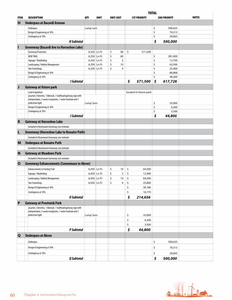
60 Chapter 4 Implementation & Management Plan
ITEM DESCRIPTION QTY UNIT UNIT COST 1ST PRIORITY 2ND PRIORITYTOTAL
NOTES
H Underpass at Bacardi AvenueUnderpass Lump sum 390,625$ Design & Engineering at 18% 70,313$ Contingency at 10% 39,063$
H Subtotal 500,000$ I Greenway (Bacardi Ave to Horseshoe Lake)
Greenway Protection 6,350 Ln Ft 90$ 571,500$
NEW TRAIL 6,350 Ln Ft 60$ 381,000$ Signage / Wayfinding 6,350 Ln Ft 2$ 12,700$ Landscaping / Habitat Management 6,350 Ln Ft 10$ 63,500$ Site Furnishings 6,350 Ln Ft 4$ 25,400$ Design & Engineering at 18% 86,868$ Contingency at 10% 48,260$
I Subtotal 571,500$ 617,728$ J Gateway at future park
Land Acquisition located in future parkassumes 2 benches, 1 bikerack, 1 trailhead/gateway sign with interpretation, 2 waste receptacles, 1 water fountain and 1 pedestrian light Lump Sum 35,000$ Design & Engineering at 18% 6,300$ Contingency at 10% 3,500$
J Subtotal 44,800$ K Gateway at Horseshoe Lake
Included in Rosemount Greenway cost estimate
L Greenway (Horseshoe Lake to Bonaire Path)Included in Rosemount Greenway cost estimate
M Underpass at Bonaire PathIncluded in Rosemount Greenway cost estimate
N Gateway at Meadows ParkIncluded in Rosemount Greenway cost estimate
O Greenway Enhancements (Connemara to Akron)Enhancements to Existing Trail 6,450 Ln Ft 10$ 64,500$
Signage / Wayfinding 6,450 Ln Ft 2$ 12,900$
Landscaping / Habitat Management 6,450 Ln Ft 10$ 64,500$
Site Furnishings 6,450 Ln Ft 4$ 25,800$
Design & Engineering at 18% 30,186$
Contingency at 10% 16,770$
O Subtotal 214,656$ P Gateway at Prestwick Park
assumes 2 benches, 1 bikerack, 1 trailhead/gateway sign with interpretation, 2 waste receptacles, 1 water fountain and 1 pedestrian light Lump Sum 35,000$
6,300$
3,500$
P Subtotal 44,800$ Q Underpass at Akron
Underpass 390,625$
Design & Engineering at 18% 70,313$
Contingency at 10% 39,063$
Q Subtotal 500,000$

Vermillion Highlands Greenway Master Plan 2012 61
ITEM DESCRIPTION QTY UNIT UNIT COST 1ST PRIORITY 2ND PRIORITYTOTAL
NOTES
R Greenway (Akron to CR 42)Greenway Protection 2,250 Ln Ft 90$ 202,500$
NEW TRAIL 2,250 Ln Ft 60$ 135,000$
Signage / Wayfinding 2,250 Ln Ft 2$ 4,500$
Landscaping / Habitat Management 2,250 Ln Ft 10$ 22,500$
Site Furnishings 2,250 Ln Ft 4$ 9,000$
Design & Engineering at 18% 30,780$
Contingency at 10% 17,100$
R Subtotal 202,500$ 218,880$ S Underpass at CR 42
Underpass 648,438$
Design & Engineering at 18% 116,719$
Contingency at 10% 64,844$
S Subtotal 830,000$
First Priority Subtotal 2,243,411$ Second Priority Subtotal 3,790,128$
Segment 1 Subtotal
Segment 2: DCTC to Whitetail Woods Regional ParkT Trailhead at DCTC
assumes 2 benches, 2 bike racks, 4 picnic tables, 1 shelter restroom with attached picnic shelter, 1 vehicle oriented landmark sign, 2 waste receptacles, 1 water fountain 250,000$ Design & Engineering at 18% 45,000$ Contingency at 10% 25,000$
T Subtotal 320,000$ U Greenway (DCTC to CR 46)
NEW TRAIL 8,500 Ln Ft 60$ 510,000$ Signage / Wayfinding 8,500 Ln Ft 2$ 17,000$ Landscaping / Habitat Management 8,500 Ln Ft 10$ 85,000$ Site Furnishings 8,500 Ln Ft 4$ 34,000$ Design & Engineering at 18% 116,280$ Contingency at 10% 64,600$
U Subtotal 826,880$ V Underpass at CR 46
Underpass 468,750$ Design & Engineering at 18% 84,375$ Contingency at 10% 46,875$
V Subtotal 600,000$
6,033,539$
based on shared facilities/partnership with City of Rosemount, DCTC

62 Chapter 4 Implementation & Management Plan
ITEM DESCRIPTION QTY UNIT UNIT COST 1ST PRIORITY 2ND PRIORITYTOTAL
NOTES
W Greenway (CR 46 to 170th Street)NEW TRAIL 5,800 Ln Ft 60$ 348,000$ Signage / Wayfinding 5,800 Ln Ft 2$ 11,600$ Landscaping / Habitat Management 5,800 Ln Ft 10$ 58,000$ Site Furnishings 5,800 Ln Ft 4$ 23,200$ Design & Engineering at 18% 79,344$ Contingency at 10% 44,080$
W Subtotal 564,224$ X Underpass at 170th Street
Underpass 421,875$
Design & Engineering at 18% 75,938$
Contingency at 10% 42,188$
X Subtotal 540,000$
First Priority Subtotal
Second Priority Subtotal 2,851,104$
Segment 2 Subtotal
Segment 3: Whitetail Woods Regional Park to Vermillion RiverY Greenway (170th St to New Regional Park northeastern border)
NEW TRAIL 1,750 Ln Ft 60$ 105,000$ Signage / Wayfinding 1,750 Ln Ft 2$ 3,500$ Landscaping / Habitat Management 1,750 Ln Ft 10$ 17,500$ Site Furnishings 1,750 Ln Ft 4$ 7,000$ Design & Engineering at 18% 23,940$ Contingency at 10% 13,300$
Y Subtotal 170,240$ Z Greenway through Whitetail Woods Regional Park
To be completed with park development Dakota County - Parks Department
AA Trailhead at Whitetail Woods Regional Park Visitors Center
To be completed with park development Dakota County - Parks Department
BB Greenway ( Whitetail Woods Regional Park southwestern border to 190th St)
NEW TRAIL 5,400 Ln Ft 100$ 540,000$ assumes additional costs for poor soils
Signage / Wayfinding 5,400 Ln Ft 2$ 10,800$ Partnership with MnDNR
Landscaping / Habitat Management 5,400 Ln Ft 10$ 54,000$
Site Furnishings 5,400 Ln Ft 4$ 21,600$
Design & Engineering at 18% 112,752$
Contingency at 10% 62,640$
BB Subtotal 801,792$ CC Greenway (190th Street to Vermillion River)
NEW TRAIL 5,800 Ln Ft 100$ 580,000$ assumes additional costs for poor soils
Signage / Wayfinding 5,800 Ln Ft 2$ 11,600$ Landscaping / Habitat Management 5,800 Ln Ft 10$ 58,000$
Site Furnishings 5,800 Ln Ft 4$ 23,200$ Design & Engineering at 18% 121,104$ Contingency at 10% 67,280$
CC Subtotal 861,184$
2,851,104$

Vermillion Highlands Greenway Master Plan 2012 63
Table 63. Vermillion Highlands Greenway Operations and Maintenance Cost estimates
ITEM DESCRIPTION QTY UNIT UNIT COST SUBTOTAL UNIT COST SUBTOTAL TOTALSEGMENT 1: Lebanon Hills Regional Park to DCTC
Trailhead at Schulze Beach Included in Lebanon Hills Regional Park O&M budgets
Trail Corridor and Gateways 6.00 Miles 7,500$ 45,000$ 15,000$ 90,000$ 135,000$
Grade Separated Crossings - Underpass 4.00 EA 3,000$ 12,000$ 10,000$ 40,000$ 52,000$
1 Subtotal 57,000$ 130,000$ 187,000$
SEGMENT 2: DCTC to Whitetail Woods Regional ParkTrail Corridor and Gateways 2.75 Miles 7,500$ 20,625$ 15,000 41,250$ 61,875$
Trailhead at DCTC 1.00 LS 15,000$ 15,000$ 20,000$ 20,000$ 35,000$
Grade Separated Crossings - Underpass 2.00 EA 3,000$ 6,000$ 10,000$ 20,000$ 26,000$
2 Subtotal 41,625$ 81,250$ 122,875$
SEGMENT 3: Whitetail Woods Regional Park to Vermillion River
Trailhead at Whitetail Woods Regional Park Included in Park O&M budgets
Trailhead at Empire Fields Park 1.00 LS 15,000$ 15,000$ 20,000$ 20,000$ 35,000$
Trail Corridor and Gateways 4.70 Miles 7,500$ 35,250$ 15,000$ 70,500$ 105,750$
Grade Separated Crossings - Underpass 1.00 EA 3,000$ 3,000$ 10,000$ 10,000$ 13,000$
3 Subtotal 53,250$ 100,500$ 153,750$
GREENWAY TOTAL 151,875$ 311,750$ 463,625$
Annual Operations and Maintenance
Annual Cost for Capital Maintenance/Facility Replacement
replacement every 25 years for trail and trailheads, every 50 years for grade separated crossings
ITEM DESCRIPTION QTY UNIT UNIT COST 1ST PRIORITY 2ND PRIORITYTOTAL
NOTES
DD Trailhead at Empire Fields Parkassumes 2 benches, 2 bike racks, 4 picnic tables, 1 shelter restroom with attached picnic shelter, 1 vehicle oriented landmark sign, 2 waste receptacles, 1 water fountain 250,000$
Design & Engineering at 18% 45,000$
Contingency at 10% 25,000$
DD Subtotal 320,000$ EE Underpass at Biscayne Ave W
Underpass 468,750$
Design & Engineering at 18% 84,375$
Contingency at 10% 46,875$
EE Subtotal 600,000$
First Priority Subtotal 1,982,976$
Second Priority Subtotal 770,240$
Segment 3 Subtotal
First Priority Subtotal 4,226,387$
Second Priority Subtotal 7,411,472$
Vermillion Highlands Greenway Total 11,637,859$
2,753,216$

64 Chapter 4 Implementation & Management Plan
Table 64. Vermillion Highlands Greenway Natural resources investments Cost estimates
Vermillion Highlands Greenway Natural Resources Cost Estimate2012 Master Plan
ITEM DESCRIPTION QTY UNIT UNIT COST TOTAL UNIT COST BUDGETSEGMENT 1: Lebanon Hills Regional Park to DCTC
Lebanon Hills Regional Park Habitat & Water Quality ManagementNatural Resource Management
McMenomy WoodsPreservation and invasive species management 164 Acre $ 350 $ 57,400
Horseshoe LakeInvasive species management (buckthorn, box elder, reed canary grass) 15 Acre 300$ 4,500$ Lakeshore Buffer plantings 15 Acre 1,000$ 15,000$ LS 10,000$ Wetland Restoration 24 Acre 2,600$ 62,400$ LS 5,000$
Subtotal 77,400$ 76,900$
SEGMENT 2: DCTC to Whitetail Woods Regional Park
UMore Park300-foot habitat corridor from DCTC to UMore Park boundary 74 Acre 2,600$ 192,400$ 350$ 25,900$
Subtotal 192,400$ 25,900$
SEGMENT 3: Whitetail Woods Regional Park to Vermillion River
Whitetail Woods Regional ParkNatural Resource Management
Vermillion Highlands WMA/AMANatural Resource Management
Empire Township Greenway Corridor300-foot habitat corridor from New Regional Park to Vermillion River 76 Acre 2,600$ 197,600$ 350$ 26,600$
Subtotal 197,600$ 26,600$
TOTAL 467,400$ 129,400$
Empire Township, Dakota County Soil and Water Conservation District, Vermillion River Watershed JPO,
MnDNR
City of Rosemount, Dakota County Soil and Water Conservation District, Vermillion River Watershed JPO
YEARLY MAINTENANCE PARTNER OPPORTUNITIES
City of Rosemount, Dakota County Soil and Water Conservation District, Vermillion River Watershed JPO
Natural resource projects and strategies to be determined per the Lebanon Hills Regional Park Master Plan
Natural resource projects and strategies to be determined per theWhitetail Woods Regional Park Master Plan
Natural resource projects and strategies to be determined per the Vermillion Highlands Master Plan
CAPITAL PROJECTS

Vermillion Highlands Greenway Master Plan 2012 65
This page intentionally blank

VerMilliON HiGHlANDs
GreeNWAY MAsTer PlAN
2012

Vermillion Highlands Greenway Master Plan 2012 67
Appendix:Public Review
A
Vermillion Highlands Greenway Open House 12/8/11The first open house was held Dec. 8, 2011, at the Rosemount Community Center to gather input on the greenway alignment, interpretive themes and approach to natural resources and water quality improvements. Dakota County staff notified all landowners within ¼ mile of the Vermillion Highlands Greenway by mail with a brochure outlining the project and an invitation to the open house. More than 40 people attended the open house, including property owners, interested residents and public officials. Many property owners came with questions and concerns, but overall there was support for the greenways.
Comments and concerns included:
f Timing of the trail.
f Funding / if property owners would be assessed for trail construction.
f Comments about the UMore alignment included:
f Link the greenway to the future research station along CSAH 46.
f Follow natural landscape patterns outlined in the UMore Master Plan.
f Interpret the Gopher Ordnance Works structures that remain
f Many people would like see grade-separated crossings and/or controlled intersections across CSAH 42 to connect to Dakota County Technical College and a potential future fieldhouse.

a-68 Appendix A Public review
Vermillion Highlands Greenway Open House 4/25/12
A second open house was held April 25, 2012, at the Rosemount Community Center to provide feedback on the draft master plan. Dakota County staff notified all landowners within ¼ mile of the Vermillion Highlands Greenway by mail with a brochure outlining the project and an invitation to the open house. Approximately 30 people attended the open house, including property owners, interested residents and public officials. Many property owners came with questions and concerns, but overall there was support for the greenways. In addition to the open house, the plans, along with the ability to comment online, were posted on the project website from the middle of April through the end of May.
Comments and concerns were similar to those expressed at the first open house. and included:
f Rosemount resident: I am a landowner in Rosemount with a large amount of land just east of Bacardi Avenue. My family has farmed this land for many years. I support these greenway trail plans and am interested in working with the County on a trail alignment on or adjacent to my property. I believe that a number of my neighbors are also interested and would be willing to work with the County as well.
f Two Rosemount landowners: I wish the greenways were in place years ago.
Online comments:
f The costs for this will be excessive. Your focus should be on reducing taxes, not developing large projects with on-going costs such as this. I am strongly opposed to this project. Funding that comes from “other sources” still comes from us.
f I think the rural trails that are planned need to be well thought out so as to not ruin the residents’ rural living experience. Also to be taken into consideration when placing trails is who owns the land — private citizen vs. the refinery. It would seem to be a better plan to “acquire” land from the refinery than to take land from private citizens who will then have a trail in the front yard. While not opposed to a trail, I do not want the trail going through my front yard and having my property value go down even further than it has because my property is on a public trail and has the lost the private rural feel.
Vermillion Highlands Greenway Master Plan 2012 a-69

a-70 Appendix A Public review

Vermillion Highlands Greenway Master Plan 2012 a-71

July 23, 2012 Mr. John Mertens Dakota County Office of Planning and Analysis 14955 Galaxie Avenue Apple Valley, MN 55124 Dear Mr. Mertens: This letter expresses Dakota County Technical College’s strong support for the Vermillion Highlands Greenway Master Plan. The 11-mile regional greenway from Rosemount to Empire Township will provide an important linkage between Lebanon Hills Regional Park and the more than 3,000 acres of public land in the Vermillion River AMA/WMA and Whitetail Woods Regional Park. The walking and bicycle connections the greenway provides will be valuable assets to both the community and the college. The proposed underpass on County Road 42 will significantly improve safety for those wishing to walk or bike to our campus. The greenway concept also supports the college’s strategic sustainability initiatives. The vision, alignment, key initiatives and implementation strategies of the Vermillion Highlands Master Plan will be considered in future campus planning efforts. Dakota County Technical College looks forward to continued collaboration with Dakota County and the City of Rosemount in the implementation of the Vermillion Highlands Greenway. Sincerely,
Ronald E. Thomas, Ph.D. President Dakota County Technical College [email protected] | 651-423-8213
a-72 Appendix A Public review

VerMilliON HiGHlANDs
GreeNWAY MAsTer PlAN
2012

VerMilliON HiGHlANDs
GreeNWAY MAsTer PlAN
2012


