87
Verve Energy Report for Warradarge Windfarm Landscape and Visual Impact Assessment April 2012

Verve Energy
Report for Warradarge Windfarm Landscape and Visual Impact
Assessment
April 2012
61/27826/207081 Warradarge Windfarm Landscape and Visual Impact Assessment
This Landscape and visual impact assessment (“Report”):
1. has been prepared by GHD Pty Ltd (“GHD”) for Verve Energy;
2. may only be used and relied on by Verve energy;
3. must not be copied to, used by, or relied on by any person other than Verve Energy without the prior written consent of GHD;
4. may only be used for the purpose of development application (and must not be used for any other purpose).
GHD and its servants, employees and officers otherwise expressly disclaim responsibility to any person other than Verve Energy arising from or in connection with this Report.
To the maximum extent permitted by law, all implied warranties and conditions in relation to the services provided by GHD and the Report are excluded unless they are expressly stated to apply in this Report.
The services undertaken by GHD in connection with preparing this Report:
were limited to those specifically detailed in section 4 of this Report;
The opinions, conclusions and any recommendations in this Report are based on assumptions made by GHD when undertaking services and preparing the Report (“Assumptions”), including (but not limited) to those outlined in section 4.10:
GHD expressly disclaims responsibility for any error in, or omission from, this Report arising from or in connection with any of the Assumptions being incorrect.
Subject to the paragraphs in this section of the Report, the opinions, conclusions and any recommendations in this Report are based on conditions encountered and information reviewed at the time of preparation and may be relied on until, September 2012, after which time GHD expressly disclaims responsibility for any error in, or omission from, this Report arising from or in connection with those opinions, conclusions and any recommendations.

61/27826/207081 Warradarge Windfarm Landscape and Visual Impact Assessment
Contents
1. Introduction 1
1.1 Background 1
1.2 Proposal Overview 2
1.3 Purpose and Structure of the Report 2
2. Description of the Proposal 4
2.1 Study Area Locality 4
2.2 Proposal Components 4
3. Legislative framework 6
3.1 Introduction 6
3.2 Statutory Mechanisms 6
4. Scope and methodology 10
4.1 Scope 10
4.2 Consultation 10
4.3 Methodology 10
4.4 Assessment Guidelines 12
4.5 Impact Assessment (Landscape) 12
4.6 Impact Assessment (Visual) 14
4.7 Cumulative Impacts 17
4.8 Mitigation 17
4.9 Limitations 18
4.10 Assumptions 18
5. Existing values 22
5.1 Introduction 22
5.2 Landscape character units 22
5.3 Sensitive receptors 25
6. Impact Assessment 34
6.1 Introduction 34
6.2 Cumulative Impacts 51
7. Mitigation 52
7.1 Construction 52

61/27826/207081 Warradarge Windfarm Landscape and Visual Impact Assessment
7.2 Operation 52
8. Summary and Conclusions 54
9. References 56
Table Index Table 1 Landscape sensitivity 13
Table 2 Landscape capacity to accommodate change 13
Table 3 Assessment of Visual Impact 14
Table 4 Visual sensitivity definitions 16
Table 5 Duration of impacts 16
Table 6 Quality of the impact 16
Table 7 Significance of impact 17
Table 9 View location 2 – visual context 27
Table 10 View location 3 – visual context 28
Table 11 View location 4 – visual context 29
Table 12 View location 5 – visual context 30
Table 13 View location 6 – visual context 31
Table 14 View location 7 – visual context 32
Table 15 Summary of Impacts 55
Figure Index Figure 1 Location Map 58
Figure 2 Topography 59
Figure 3 Photomontages Locations 60
Figure 4 Landscape Character Map 61
Figure 5 Zone of Theoretical Visibility - 100m Hub Height 62
Figure 6 Zone of Theoretical Visibility - 152m Tip Height 63
Figure 7 Cumulative Impact - Tip Height 64
Appendices A Maps
B Photomontages

61/27826/207081 Warradarge Windfarm Landscape and Visual Impact Assessment
Glossary of terms
Term Definition
Background view Landscape visible in distance (6 km to 20 km) where textures are no longer visible, but mountain and valley forms, skylines and ridgelines are important.
Cumulative impact An impact produced by the accumulation of successive additions of individual impacts, which may not themselves be significant.
Ecological community An assemblage of populations of different species, interacting with one another.
Ecosystem A natural unit consisting of all organisms in an area functioning together with all the non-living physical factors of the environment.
Flora The plant life occurring in an area.
Foreground 0 to1 km is the visual zone where colour contrast and textural detail are most clearly perceived.
Footprint An outline or indentation left by the Proposal on the surface.
Intervisibility Two points in the landscape that are mutually visible.
Landscape feature A component, part or feature of the landscape that is prominent or eye-catching, e.g. hills, buildings, vegetation.
Landscape quality Judgement of landscape value based on particular characteristics that influence the way in which the environment is experienced, including special interests such as cultural associations or heritage interests, the presence and/or type of elements and condition.
Landscape sensitivity The extent to which landscape can accept a change of a particular type and scale without unacceptable adverse impacts on its character.
Landscape value Areas of formally designated landscape that through national or local consensus, reflect the value placed by society on particular environments and/or their features.
Middle ground view 1 km - 6 km – different elements in the landscape are visually apparent
National Environmental Significance (NES)
Matters of NES as listed under the Commonwealth Environment Protection and Biodiversity Conservation Act 1999 which include World/National Heritage properties, Ramsar wetlands, nationally threatened species and ecological communities, migratory species, Commonwealth marine areas, nuclear actions and national heritage places.

61/27826/207081 Warradarge Windfarm Landscape and Visual Impact Assessment
Term Definition
Sensitive visual receptor Person and/or viewer group that would experience an impact.
Viewing locations Viewing locations are used in this report to typify the views experienced by sensitive visual receptors throughout the visual catchment of the Proposal. Viewing locations in this report often represent a viewing area, rather than one exact point.
Visual amenity The value of a particular area or view in terms of what is seen.
Visual impact Changes in the appearance of the landscape or in the composition of available views as a result of development, to people‟s responses to these changes, and to the overall impacts in regard to visual amenity. This can be positive (i.e. beneficial or an improvement) or negative (i.e. adverse or a detraction).
Visual catchment (study area) Extent of potential visibility to or from a specific area, feature or project.

61/27826/207081 Warradarge Windfarm Landscape and Visual Impact Assessment
Abbreviations
3D Three dimensional
AHD Australian Height Datum
CEMP Construction and Environmental Management Plan
DEC Department of Environment and Conservation
EP Act Environment Protection Act of Western Australia
EPA Environment Protection Agency
EPBC Environment Protection and Biodiversity Conservation Act
ES Environmental Statement
GA Geoscience Australia
GIS Geographic Information Systems
Ha Hectare
km Kilometres
kV Kilovolts
LCU Landscape Character Unit
LVIA Landscape and visual impact assessment
m Metres
m² Metres squared
mm Millimetres
MW Megawatts
NP National Park
NR Nature Reserve
SRTM Shuttle Radar Topography Mission
WA Western Australia
WAPC Western Australian Planning Commission
WTG Wind Turbine Generators
ZTV Zone of Theoretical Visibility

1 61/27826/207081 Warradarge Windfarm Landscape and Visual Impact Assessment
1. Introduction
GHD has been commissioned by Verve Energy Pty Ltd to undertake a study of Landscape and Visual Impacts of the proposed Warradarge Wind Farm (The Proposal) (Appendix A, Figure 1). The study area is located approximately 240km north of Perth, Western Australia, and 15 kilometres (km) south east of Eneabba. The proposed wind farm is located predominately within the Shire of Coorow with a transmission line corridor passing into the Shire of Carnamah. The Warradarge Wind Farm involves the development of a wind farm capable of generating an energy output of 250 Megawatt (MW) and will comprise up to 100 individual wind turbines.
This study was commissioned in January 2012 and is to be undertaken in two key stages: preliminary information and baseline assessment comprising gathering of interim advice and data on key landscape and visual impact issues, fieldwork, baseline studies undertaken in February 2012, and; assessment reporting including development of appropriate plans and photomontages for inclusion in the final report, consultation with key stakeholders, outlining any mitigation strategies and providing a summary assessment. This landscape and visual impact assessment (LVIA) has been undertaken using the greatest impact (worst case) specification of the Proposal.
1.1 Background The Warradarge Wind Farm proposes wind turbines sited throughout predominately cleared rural land.
The region predominantly comprises cleared rural agricultural land (and use), with pockets of remnant vegetation, together with areas of significant remnant native vegetation and ecological communities directly north, east and south of the study area. This includes a number of national parks and nature reserves as shown on figure 3 within a 25 km radius of the study area, including:
Alexander Morrison National Park
South Eneabba Nature Reserve
Coomallo Nature Reserve
Tathra National Park
Wotto Nature Reserve
There are no registered sites of Aboriginal heritage within the proposed Warradarge Wind Farm area.
The subject site is characterised by gentle undulating plains with areas of complex table-top topography, as indicated within photomontage (Appendix B). Several small creeks/drainage channels traverse the subject site, as well as a number of residential dwellings located around the subject site.
This assessment has considered existing landscape quality as a key characteristic in reaching conclusions about the likely impact on the surrounding amenity from the point of view of both residents and visitors.
This comprehensive study has comprised the identification of key travel routes, including the West Midlands Wildflower Tourist Drives, natural characteristics and significant features including the mapping of sensitivity zones and view sheds. This information has been analysed by overlaying distance bands to help understand impacts on visual amenity as a result of the presence of the turbines.

2 61/27826/207081 Warradarge Windfarm Landscape and Visual Impact Assessment
Further to this field research: data collation and geographic information system (GIS) analyses have been carried out in order to ensure the wind farm‟s impact on visual amenity and the community‟s perception of this are assessed in both quantitative and qualitative manners. This has ensured a comprehensive assessment of the Warradarge Wind Farm and its presence within the region.
1.2 Proposal Overview The construction of the Warradarge wind farm is likely to occur over 3 stages, with the first stage expected to be commenced in January 2015 and the final Stage to be completed by January 2021.
The final number, height, location and make/model of each turbine has not yet been determined. This is due to the fact that the capacity of a proposed new 330 kV transmission line proposed to be utilised by the Warradarge proposal is not yet known. The make/model of the individual turbines will not be determined until a post Development Approval tender process. Therefore, at the time of writing this report, the LVIA has been based upon the assumption of the „worst case‟ scenario (i.e. the maximum number and height of wind turbines). Therefore, this assessment also encompasses consideration for smaller turbines that may be built. Based upon this assumption, a summary of the key components of the proposal will comprise:
100 wind turbine generators (WTG) with an overall tip height of 152 metres (m).
3 anemometer masts.
Underground cabling between turbines and substation.
Hardstand areas for cranes and adjacent to pylons.
A substation.
A 10km overhead transmission line.
New and upgraded access tracks.
A construction compound containing site offices and welfare facilities.
1.3 Purpose and Structure of the Report This LVIA describes the assessment of the landscape and visual effects arising as a result of the proposed Warradarge Wind Farm. The methodology of the assessment has been outlined and includes a description of the process by which impacts have been identified and the level of significance of these effects is determined. This methodology has been developed to respond specifically to both statutory and non-statutory requirements/guidelines, as set out in Section 3 below.
In summary, this report is structured as follows:
Proposal background; description of the Proposal design and visual components; relevant consultation legislation, policies and guidelines that have been used to inform the assessment.
Scope of the assessment; methodology adopted to assess effects upon landscape and visual amenity and the limitations and assumptions of this method.
Evaluation of the baseline landscape and visual context, including description of the visual catchment through landscape character types and identification of representative viewing
3 61/27826/207081 Warradarge Windfarm Landscape and Visual Impact Assessment
locations/sensitive receptors, and; discussion of visual receptor sensitivity through the use of representative publicly accessible viewpoints.
An assessment of the significance of effects upon landscape and visual amenity, including:
- GIS viewshed analysis to understand the visual exposure of the Proposal from representative viewing locations.
- Identification of the sources of potential landscape and visual impacts associated with the Proposal.
- Providing a description of landscape and visual impacts for each viewing location, having regard to criteria such as scenic quality, visual and landscape sensitivity, and the significance of likely impacts.
- Description of cumulative impacts, including GIS based modelling.
- Proposing general mitigation strategies to avoid, reduce, remedy or offset negative visual impacts resulting from the Proposal.
Conclusions and a summary of findings.
4 61/27826/207081 Warradarge Windfarm Landscape and Visual Impact Assessment
2. Description of the Proposal
2.1 Study Area Locality The Proposal is proposed to be located between Rose Thomson Road and Garibaldi Willis Road, approximately 15 km north-east of Warradarge, 15 km south-east of Eneabba and 40 km south-west of Carnamah. It is proposed on private farming land (Part Lots 10848, 10850, 10851, 10853 and 10847) and will comprise a development footprint of approximately of 80 hectares (ha) with the majority being on cleared agricultural land, with upto 0.8 ha of vegetated land being developed. The site boundary itself forms an area of up to 5010 ha.
2.2 Proposal Components The Warradarge Wind Farm will consist of up to 100 wind turbine generators (WTG) with a maximum generating capacity of 250 MW. The wind turbine design would be a three-bladed, horizontal axis wind turbine, up to 152 m maximum height to the tip.
The 100 turbine layout assessed is spaced across the greatest amount of overall land area within the site boundary and as such the width of any view of the wind farm is greatest from any viewpoint. Therefore a fewer number of turbines within the site boundary, or 100 turbines located in different locations within the wind farm envelope , as shown on Figure 1, is also encompassed by the assessment.
The wind farm would have associated above and below ground ancillary works, including (but not limited to):
100 WTG, with a rotor diameter of up to 104 m on a 100 m hub, giving an overall tip height of 152 m and associated 25 m x 40 m hardstands directly adjacent to enable construction and decommissioning. These will be within an area of approximately 3800 ha of the total site boundary..
The colour and finish of the WTG rotor blades, nacelles and towers will be a pale grey colour with a semi-matt finish as is typical of many wind turbine finishes.
Three long term anemometer masts
Underground cabling between turbines and substation.
A 10 km transmission line connection the onsite substation to the Eneabba to Karara line. This line would comprise up to 20 pylons, between 50 m and 63 m in height, spaced every 500 m - 600 m and would be constructed of lattice steel. This is to be routed through Lots 10847, 10848, 10850 and 10851 to the grid connection point and is shown in figure 1 as the Transmission line corridor.
The pylon would be constructed on a cleared hardstanding area of 50 m X 30 m, totalling 1500 m² for each pylon.
8.5 km of new and upgraded access tracks, including access to public highway.
Electricity transformers
Crane hardstandings

5 61/27826/207081 Warradarge Windfarm Landscape and Visual Impact Assessment
A 22/330 kilovolt (kV) substation comprising associated electrical infrastructure (transformers, circuit breakers, switchgear, etc), site office with toilet and welfare facilities and a storage area for maintenance equipment. Staff would not be on site permanently and the building would be visited periodically by maintenance personnel.
Whilst the proponent sees no reason install obstacle lighting it is out of the proponents control if in the future if the Civil Aviation Safety Authority (CASA) insist on these. These lights have not being considered as part of this assessment. In the instance of CASA regulations changing regarding the installation of aviation lights, the night time visibility of the aviation lights would have the same visibility as the Zone of Theoretical Visibility (ZTV) as the 100m high turbine hubs, as per Figure 5.
The wind farm is likely to be commissioned in three stages, with an approximate 2 year gap between the commissioning of each of the three stages. It is expected that construction of the first stage will start in January 2015 and take up to 24 months. Once the first stage is completed the second stage will be started and will take approximately 18 months to complete. Once stage two is complete, stage three will be started and is anticipated to also take 18 months. The first stage will take longer to construct as the site entrance, construction compound, substation and grid connection line will need to be constructed. Stages 2 and 3 will take advantage of this infrastructure to shorten the construction time.
It is expected that Stage one will supply electricity in January 2017, Stage 2 in January 2019 and Stage 3 in January 2021.
During the construction and commissioning there would be a number of temporary works including:
A construction compound containing site offices and welfare facilities of approximately 100 m x 100 m in size.
Temporary crane hardstands.
Laydown area.
Rotor assembly pads.
Three guyed anemometer masts up to 100 metres high.
Two site entrances off the Garabaldi Willis Road onto the site.
6 61/27826/207081 Warradarge Windfarm Landscape and Visual Impact Assessment
3. Legislative framework
3.1 Introduction The Proposal is subject to Commonwealth, state and local government environmental legislation, which have been outlined in the following sections.
3.2 Statutory Mechanisms Existing statutes and mechanisms that provide authority to this LVIA have been outlined below.
3.2.1 National Legislative Framework
Environment Protection and Biodiversity Conservation Act 1999 The Environment Protection and Biodiversity Conservation Act 1999 (EPBC Act) protects those aspects of the environment that are of national environmental significance and heritage value. The protection of the environment includes the qualities and characteristics of locations, places and areas; and heritage values of places.
Environmental Protection Act (EP Act) of Western Australia 1986 Part IV (Environmental Impact Assessment) of the Environmental Protection Act of WA has the potential to take issue on visual impact matters.
National Wind Farm Development Guidelines (Draft) The Draft National Wind Farm Development Guidelines (the Guidelines) were prepared by the Environment Protection and Heritage Council of Australia and released in July 2010. The Draft Guidelines provide a nationally consistent set of best-practice methods for assessing the impacts that are unique or significant to wind farm developments and operations. The Guidelines have been used in conjunction with the relevant state, territory and local government planning and environmental regulations and/or guidelines.
The Guidelines specifically address impacts on landscape values which can be addressed through the preparation of visual landscape assessment/ significance analysis, view shed and view analysis.
3.2.2 State Planning Framework
Western Australian Planning Commission (WAPC) The WAPC has developed broad statutory policy measures at regional, local and site levels. The Environment and Natural Resource State Planning Policy No.2 (2003) sets out to ensure recognition of the significance of visual and landscape protection, maintenance and enhancement:
“Protect significant natural, indigenous and cultural features, including sites and features significant as habitats and for their floral, cultural, built, archaeological, ethnographic, geological, geomorphological, visual or wilderness values”.
“Identify and safeguard landscapes with high geological, geomorphological or ecological values, as well as those of aesthetic, cultural or historical value to the community, and encourage the restoration of those that are degraded.”

7 61/27826/207081 Warradarge Windfarm Landscape and Visual Impact Assessment
“…consider the level or capacity of the landscape to absorb new activities and incorporate appropriate planning and building design and siting criteria to ensure that new development is consistent and sensitive to the character and quality of the landscape.”
“Consider the need for a landscape, cultural or visual impact assessment for land use or development proposals that may have a significant impact on sensitive landscapes.”
Planning Bulletin No.67: Guidelines for Wind Farm Development Planning Bulletin No.67 (PB67) was prepared to provide local government, other relevant approval authorities and wind farm developers with a guide to the planning framework for the balanced assessment of land-based wind farm developments throughout Western Australia. The Bulletin is the principal tool for the assessment of planning applications relating to wind farms in Western Australia. It provides guidance in the design and siting of wind farms. The key objective of PB67 of direct relevance to this report is to:
Minimise disturbance to the environment (including landscape) and loss of public amenity in the establishment, operation, maintenance and decommissioning of wind farms.
The following provides a summary of the key issues cited in PB67 that will be considered in the decision-making process and of direct relevance to this report. Landscape and Visual Impact – the degree to which a wind farm development will impact on the landscape will depend on:
Siting, layout and design of the turbines, infrastructure, signage and ancillary facilities.
Number, colour, shape, height and surface reflectivity of the towers and blades.
Visibility of the development, having regard to the location, distance from which the development is visible, skyline and view-sheds.
Significance and sensitivity of the landscape, having regard to topography, the extent and type of vegetation, natural features, land use patterns, built form character and community values.
Department of Environment and Conservation (DEC) The DEC developed the Visual Resource Management on Lands and Waters Managed by CALM (1989) to:
“ensure that all land uses and waters managed by CALM are planned and carried out in ways that sustain the beauty of the natural environment”,
and to;
“…..ensure that all uses and activities are planned and implemented so as to complement rather than detract from the inherent visual qualities of the environments in which they occur.”
The DEC also publish data associated with the Wildflower Drives of the West Midlands Region. These are tourist drives, and do not have any formalised legislative protection or status (CALM, 2001).
Environmental Protection Agency (EPA) The EPA provides advice on the protection of visual amenity through its Environmental Guidance for Planning and Development: Guidance Statement No. 33 (2005). The statement aims to provide advice the protection on visual amenity (Chapter D3, Visual Amenity) and natural and human-modified

8 61/27826/207081 Warradarge Windfarm Landscape and Visual Impact Assessment
landscapes and landforms (Chapter B8 Landscape and Landforms) during land use planning and development processes under the Environmental Protection Act 1986.
Visual Landscape Planning in Western Australia – A Manual for Evaluation, Assessment, Siting and Design (2007) The Visual Landscape Planning Manual addresses fundamental tools of visual landscape evaluation and visual impact assessment and provides guidelines for siting and design in relation to a range of landscape types and land uses. It establishes a series of state, regional, local and site level principles and guidelines with respect to wind farms (e.g. avoiding significant landscapes, minimising impact through the layout, size, number and colour of turbines and associated infrastructure, minimising earthworks and implementing a program of rehabilitation).
The components of wind turbines/wind farms identified as potentially impacting upon the surrounding landscape and visual character comprise:
Project area.
Layout.
Turbine size (tower height and rotor size)
Turbine rotational speed.
Number of turbines.
Colour of turbines.
Reflectivity of rotating blades.
Access roads.
Ancillary features (e.g. buildings, signage, telecommunications infrastructure and transmission lines).
Extent of clearing.
Construction procedures.
Rehabilitation measures.
3.2.3 Regional Planning Framework
Mid West Regional Planning and Infrastructure Framework (Draft)
The Warradarge Wind Farm proposal is situated within the Mid-West region of Western Australia. Once finalised, the Mid-West Regional Planning and Infrastructure Framework (the Framework), released in November 2011, will become a second tier document preceded by the WA State Planning Strategy (1997) and will be recognised as a regional strategy under the State Planning Framework.
The key objective of the Draft Framework of direct relevance to this study is Section 2.3.3 Landscape and Geology, which identifies the broad landscape type of the Geraldton Plain and states that: “distinct landscape features with high natural and scenic quality are retained in order to maintain the Mid West‟s unique „sense of place‟”.

9 61/27826/207081 Warradarge Windfarm Landscape and Visual Impact Assessment
3.2.4 Local Planning Frameworks
Local Planning Frameworks identified (of relevance to this study) are identified as the Shire of Carnamah and the Shire of Coorow.
Shire of Coorow Town Planning Scheme No.2 The proposed Warradarge Wind Farm is located within a „Rural‟ zone of the Shire of Coorow Town Planning Scheme No.2 (TPS2).
Clause 1.6 of TPS2 sets out the general objectives of the Scheme. The key objective for the Scheme, relevant to this report is:
To safeguard and enhance the character and amenity of the built and natural environment of the Scheme area.
Shire of Carnamah Town Planning Scheme No,1. A portion of the proposed transmission line which runs north-west from the proposed wind farm, crossing into the Shire of Carnamah, is located within a „Rural‟ zone of the Shire of Carnamah‟s Town Planning Scheme No.1 (TPS1).
Of relevance to this study and in accordance with Clause 5.7 of TPS1 is:
“…the need to preserve the rural character and rural appearance of the land within this zone‟.
3.2.5 Other Relevant Studies
Relevant studies considered within the writing of this report include:
Best Practice Guidelines for Implementation of Wind Energy Projects in Australia (2006)
Wind Farms and Landscape Values: Stage One Final Report – Identifying Issues (2005)
Windfarms and Landscape Value (2004)
Visual Assessment of Windfarms Best Practice (2002)
Renewable Energy Handbook for Western Australia (2006)

10 61/27826/207081 Warradarge Windfarm Landscape and Visual Impact Assessment
4. Scope and methodology
4.1 Scope The term „landscape‟ describes a range of environmental topics including landscape character, landscape context, views and prospects, historical landscapes and anthropogenic landscapes.
Landscape and visual impact assessment is a combination of two separate but closely related aspects. The first is the assessment of impact upon the character of the landscape, that is, changes in the landscape, its character and quality, as a result of the new development. The second is visual impact, that is, the appearance of the changes and the resulting effects on visual amenity.
The central purpose of the LVIA is to identify potentially significant adverse impacts at the Proposal planning stage and to propose measures to mitigate or ameliorate such impacts.
4.2 Consultation Local Councils of Shire of Coorow and Shire of Carnamah were contacted during the assessment process to discuss the potential visual impacts and/or areas of concern.
4.3 Methodology
4.3.1 Desktop Study
A desktop study was undertaken to obtain relevant publically available data on visual impact and landscapes at a national, regional and local level for the study area. This included a comprehensive review of GIS data sets and an aerial photography based identification of potential sensitivity receptor locations, later ground truthed by field teams.
The following data sets were reviewed for the LVIA:
aerial photography;
topographical data;
hillshade (Shuttle Radar Topography Mission Shaded Relief);
road networks (Geoscience Australia 2007);
existing rail networks (Geoscience Australia 2007);
cadastre (DERM 2011);
watercourses (Geoscience Australia 2007);
protected areas (DERM 2011);
nature refuges (DERM 2010);
local government areas;
Interim Biogeographic Regionalisation for Australia Version 6.1 regions and subregions (SEWPAC 2005);
information from local planning authorities
11 61/27826/207081 Warradarge Windfarm Landscape and Visual Impact Assessment
4.3.2 Site Survey
A site survey was undertaken by two landscape architects to verify the desktop study, allow characterisation of the landscape, identify sensitive receptors and observe how receptors might view the landscape. The site visit was conducted in February 2012 during conditions of overcast weather with medium distance visibility.
During the site survey, the landscape architects traversed the study area (refer below to 4.3.3 for definition of the study area to gain representative views of the site (Figure 1) upon which the wind farm is proposed from both publicly accessible and private (where permission was granted) viewpoints. At each location a photographic record of landscape features, key views and receptors obtained along with coordinates, bearings, field notes and sketches.
4.3.3 Establishment of the Landscape and Visual Baseline
Defining the Visual Catchment A worst case indicative visual catchment within which the Proposal may be seen, has been defined based on the investigation area. This has been determined through a desktop study examining aerial photographs and topographic maps where landform and land cover (screening) were considered in tandem. Also taking into consideration was the potential maximum visibility for this type of development. For LVIA, the visual catchment becomes the study area which for this assessment has been set at 25 km, based upon previous studies of a similar nature and relevant guidelines for windfarm assessment.
This preliminary visual catchment is then used to identify sensitive receptors with potential views of the Proposal.
Zone of Theoretical Visibility (ZTV) More detailed assessment of potential visibility within the study area (zones of theoretical visibility) are then calculated using topographical data. A zone of theoretical visibility is the area around a designated point in the landscape from which that point is visible. It is calculated using elevation data such as a Digital Elevation Model and does not take account of buildings or vegetation screening, therefore representing a worst case.
The zones of theoretical visibility were generated for a 25 km radius from the proposed turbines at Warradarge and are based on 10 m contour intervals and with an observer eye height of 1.7 metres.
For the cumulative impact a ZTV of 25 km radius from each wind farm was generated in order to capture any potential visibility between Warradarge and Badgingarra Wind Farm (proposed).
4.3.4 Description of Existing Conditions
The description of existing landscape and visual environment establishes a baseline against which the Proposal is assessed.
Defining Landscape Character Units (LCU) Landscape character (Figure 4) considers common landscape types (defined by typical features and characteristics) and highlights any principal landscape features. A description of the landscape character differentiates between subjective assessments and objective description and is provided from both within the study area, and from the wider landscape.

12 61/27826/207081 Warradarge Windfarm Landscape and Visual Impact Assessment
The factors that have been considered in categorising the landscape character areas include landform, vegetation and intensity and character of land. The categorising was informed through a review of the information assembled in the desktop study described in section 4.3.1 and the site survey described in section 4.3.2. The assessment also included a comprehensive review of the Interim Biogeographic Regionalisation for Australia regions and subregions (DEH 2005). This national data set which classifies the land surface of Australia was derived by using specialist ecological knowledge and the assessment of climate, geomorphology, landform, lithology, and characteristic flora and fauna (DEH 2005). These attributes are common to some of the attributes used to define landscape character.
Selection of Receptor Viewpoints Representative publicly accessible viewpoints have been identified in a range of locations. These have been recorded and photographed. Photographs of viewpoints within Section 5 represent a range of typical views possible from that locality to the Proposal. Viewpoints are selected in order to:
represent views of particular landscape and /or visual features of importance, and;
represent views from key visual receptors who spend extended amounts of time and other locations from which fixed or transient views would be possible, but where the time of stay is shorter. These include residents, road, rail and recreational receptors.
4.4 Assessment Guidelines The methodology for the LVIA has been set out to respond to particular project requirements and constraints including scale and nature of the Proposal.
Whilst there is no general (legislated) guidance on the assessment of landscape and visual effects produced by an independent body specific to Australia, there is documentation specific to best practice visual assessment of windfarms. Therefore, in addition to the references set out in Section 3 above, this assessment draws on the Guidelines for Landscape and Visual Impact Assessment, Second Edition, (2002) published by The Landscape Institute and the Institute for Environmental Management and Assessment (IEMA) in the UK.
Terminology, assessment methods and nomenclature have also been derived from Visual Landscape Planning in Western Australia, produced by the Western Australian Planning Commission (2007) and the Forest Practice Board of Tasmania‟s, A Manual for Forest Landscape Management (2006).
4.5 Impact Assessment (Landscape) Landscape is defined as features (such as vegetation, built elements, topography, etc.) either within the proposal site or on land adjacent. The features of the landscape are considered as an integral part of the landscape and visual context of the route and important contributors to the overall character of the environment.
Assessment of changes to the landscape includes identification of:
the nature of the change, that is the degree of contrast, or integration of, any new features with existing features;
context and quality of the views including the extent to which the Proposal will be visible in the wider landscape (with consideration of the presence of intervening vegetation or features);

13 61/27826/207081 Warradarge Windfarm Landscape and Visual Impact Assessment
the scale or degree of change i.e. obvious / imperceptible with respect to loss or addition of features;
the nature of the impact (adverse or beneficial).
4.5.1 Landscape sensitivity
Landscape sensitivity is described in Table 1. The relative capacity of the landscape to accommodate changes of the type proposed that would occur as a direct result of the Proposal has been defined in
Table 2.
Table 1 Landscape sensitivity
Landscape sensitivity Definition
High Landscapes of international designation that are highly valued, particularly near or distinctive and susceptible to small change
Medium Landscape of regional designation that are valued more locally and tolerant of moderate levels of change
Low Landscapes of local designation that are more commonplace and potentially tolerant of noticeable change or are undergoing substantial development, such that their character is one of change.
Table 2 Landscape capacity to accommodate change
Landscape capacity Definition
Low potential capacity The landscape has high sensitivity to the type of development proposed which could have a detrimental effect on the landscape character or value. Mitigation measure unlikely to reduce the impacts of the change.
Medium potential capacity The landscape has medium sensitivity to the type of development proposed. Any change caused by the proposed development would be unlikely to have a significant adverse effect on the landscape character or value that could not be mitigated against.
High potential capacity The landscape will have low sensitivity to this type of development and few constraints imposed by landscape elements. Development of this type is very unlikely to have an adverse effect on the landscapes character. Mitigation measures will be effective in neutralising adverse effects and / or may improve the landscape character.

14 61/27826/207081 Warradarge Windfarm Landscape and Visual Impact Assessment
4.5.2 Landscape impacts
For the purposes of this assessment the definitions in Table 3 have also been used to describe visual impact.
Table 3 Assessment of Visual Impact
Landscape Impact Definition
Large A substantial / obvious change to the landscape due to total loss of, or change to, elements, features or characteristics of the landscape. Would cause a landscape to be permanently changed.
Moderate Discernible changes in the landscape due to partial loss of, or change to the elements, features or characteristics of the landscape. May be partly mitigated. The change would be out of scale with the landscape, and at odds with the local pattern and landform and will leave an impact on the landscape.
Small Minor loss or alteration to one or more key landscape elements, features, or characteristics, or the introduction of elements that may be visible but may not be uncharacteristic within the existing landscape.
Negligible Almost imperceptible or no change in the view as there is little or no loss of / or change to the elements, features or characteristics of the landscape.
4.6 Impact Assessment (Visual) People are mobile and therefore could potentially experience views of the Proposal from many different locations. In order to undertake an assessment of visual impacts, a series of key viewing locations have been selected to represent the points from which the Proposal is likely to be viewed by the greatest number of visual receptors and from where the most sensitive visual receptors are likely to perceive the Proposal.
Proposal impacts can be evaluated on the basis of a combination of two factors that inform the level of significance of impact:
visual modification;
visual sensitivity.
Both are defined in sections 4.5.2 and 4.6.3 respectively, and their use in identifying severity of the impacts outlined.
4.6.1 Photomontages
A series of seven viewing locations were selected for the production of photomontage images. These photomontages were used to represent the views available from the selected locations following the completion of the Proposal.
All photographic images were captured using a 50 millimetre (mm) fixed focal length lens on a 35 mm format (digital equivalent) camera at a camera height of 1.7 m as recommended in the IEMA guidelines (IEMA 2002).

15 61/27826/207081 Warradarge Windfarm Landscape and Visual Impact Assessment
The software that has been utilised for modelling and rendering the photomontages was Autodesk 3D Studio Max. In order to achieve an accurate photomontage of the structure and surrounding landscape, 10 m contours were used to model the surrounding landform.
Once the 3D model encapsulating both the landscape and new Proposal elements was created, a virtual camera was placed in the software at the same location that the photographs have been taken from. The film (35 mm), focal lens (50 mm) and height (1.7 m) of the virtual camera matches the real camera utilised to take the photos.
The photos of the site were used in 3D Studio Max as a background to accurately match the 3D model with the Proposal elements to the perspective of the photos.
From the camera view, rendered images of the Proposal were produced to match the daylight exposure of the photographs. The rendered images were imported into Adobe Photoshop for post-production editing and collation of the photomontages. The final result is the 3D model of the Proposal shown in the correct 3D location in the photographs. The final images were produced to a high resolution, suitable for printing.
The 3D model included the proposed 100 turbines and 20 pylons.. As discussed in section 2.2 the final height of the pylons has not been finalised but they will be between 50 m – 63 m in height. A lightly constructed height of 50 m was used to illustrate the pylons in the photomontages. Visibility in the resultant photomontages of these elements is dependent upon topography (i.e. not all elements modelled will be visible from every location).
4.6.2 Visual impacts
Visual impacts relate to the changes that arise in composition of available views as a result of changes to the existing landscape, to people‟s responses to these changes, and to the overall impacts with respect to visual amenity:
magnitude of change in the view (i.e. loss/addition of features that change the view‟s composition) and integration of changes within the existing view (form, mass, height, colour and texture);
effectiveness of proposed mitigation.
4.6.3 Visual Sensitivity
Visual sensitivity refers to visual receptors and their sensitivity to their visual environment. Visual sensitivity is defined as the perception of viewers to the proposals.
For the purposes of this assessment, key visual receptors comprise residents, users of transport routes (road and rail) as well as users of public recreation and all have differing sensitivities to their visual environment. Generally, sensitivity is derived from a combination of factors including:
receptors‟ interest in the visual environment i.e. high, medium or low interest in their everyday visual environment, and the duration of the effect;
receptors‟ duration and viewing opportunity i.e. prolonged, regular viewing opportunities;
number of viewers and their distance / angle of view from the source of the effect, extent of screening / filtering of the view, where relevant.

16 61/27826/207081 Warradarge Windfarm Landscape and Visual Impact Assessment
For the purposes of this assessment, the terminology set out in Table 4 has been used to describe visual sensitivity.
Table 4 Visual sensitivity definitions
Sensitivity Definition
High Occupiers of residential properties with long viewing periods, within close proximity to the proposed development.
Communities that place value upon the landscape and enjoyment of views of their landscape setting.
Medium Outdoor workers who have a key focus on their work who may also have intermittent views of the Proposal area.
Viewers at outdoor recreation areas located within close proximity but where viewing periods are limited.
Occupiers of residential properties with long viewing periods, at a distance from or screened / filtered views of the Proposal area.
Low Road users in motor vehicles, trains or on transport routes that are passing through the study area and have short term / transient views.
Viewers indoor at their place of work, or similar.
Neutral Viewers from locations where there is screening by vegetation or structures where only occasional views are available and viewing times are short.
4.6.4 Duration of impact
Duration of impact has been defined for the purposes of this assessment as outlined in Table 5.
Table 5 Duration of impacts
Category Duration
Temporary Impacts lasting one year or less
Short term Impacts lasting one to seven years
Medium term Impacts lasting seven to 15 years
Long term Impacts lasting 15 to 60 years
Permanent Impacts lasting over 60 years
4.6.5 Impact type
The definition type of impact as used in this assessment has been outlined in Table 6.
Table 6 Quality of the impact
Quality category Description
17 61/27826/207081 Warradarge Windfarm Landscape and Visual Impact Assessment
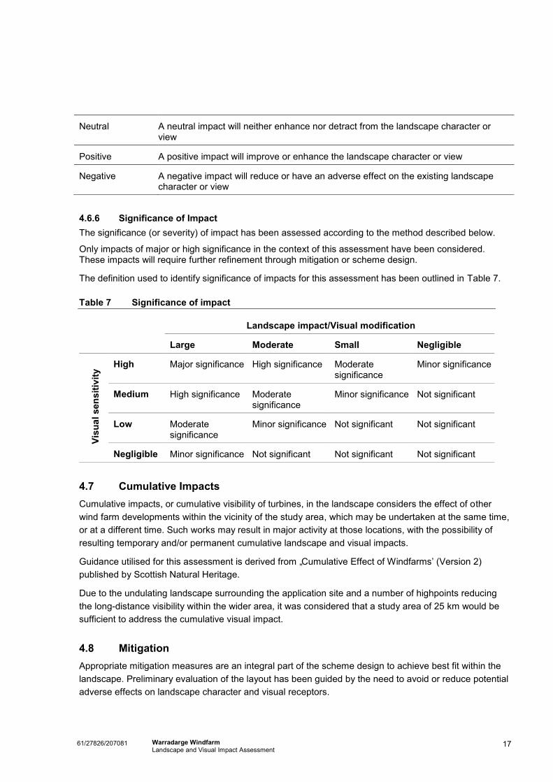
4.6.6 Significance of Impact The significance (or severity) of impact has been assessed according to the method described below.
Only impacts of major or high significance in the context of this assessment have been considered. These impacts will require further refinement through mitigation or scheme design.
The definition used to identify significance of impacts for this assessment has been outlined in Table 7.
Table 7 Significance of impact
Landscape impact/Visual modification
Large Moderate Small Negligible
Visu
al s
ensi
tivity
High Major significance High significance Moderate significance
Minor significance
Medium High significance Moderate significance
Minor significance Not significant
Low Moderate significance
Minor significance Not significant Not significant
Negligible Minor significance Not significant Not significant Not significant
4.7 Cumulative Impacts Cumulative impacts, or cumulative visibility of turbines, in the landscape considers the effect of other wind farm developments within the vicinity of the study area, which may be undertaken at the same time, or at a different time. Such works may result in major activity at those locations, with the possibility of resulting temporary and/or permanent cumulative landscape and visual impacts.
Guidance utilised for this assessment is derived from „Cumulative Effect of Windfarms‟ (Version 2) published by Scottish Natural Heritage.
Due to the undulating landscape surrounding the application site and a number of highpoints reducing the long-distance visibility within the wider area, it was considered that a study area of 25 km would be sufficient to address the cumulative visual impact.
4.8 Mitigation Appropriate mitigation measures are an integral part of the scheme design to achieve best fit within the landscape. Preliminary evaluation of the layout has been guided by the need to avoid or reduce potential adverse effects on landscape character and visual receptors.
Neutral A neutral impact will neither enhance nor detract from the landscape character or view
Positive A positive impact will improve or enhance the landscape character or view
Negative A negative impact will reduce or have an adverse effect on the existing landscape character or view

18 61/27826/207081 Warradarge Windfarm Landscape and Visual Impact Assessment
Environmental constraints and opportunities have been taken into consideration during the scheme‟s development. This iterative approach assists in avoiding or minimising potential negative effects of the scheme while also helping to identify opportunities for enhancement.
Strategies for impact mitigation include:
Avoid - Avoid developments in sensitive or prominent landscapes, and avoid insensitive or visually intrusive designs. Prevention of adverse effects at source.
Minimise – Reduction of adverse effects that cannot be eliminated by avoidance. The significance of adverse impacts is lessened. Seeks to limit the exposure of the receptor. Reduce the visual intrusiveness of the design and reduce the visibility of the Proposal (e.g. by installing screening between the location(s) of likely receptors and the source of the impact). It may serve to improve the adverse conditions by carrying out further works which seek to restore the environment e.g. increased planting of trees/shrubs to offset unavoidable loss of vegetation.
Offset - The provision of alternative or compensatory measures where appropriate and feasible (e.g. offset planting either on or off site).
If it is not possible or practical to mitigate an impact (e.g. felling mature trees), this is described as a residual impact.
4.9 Limitations There are a number of assumptions and limitations associated with this assessment, as follows:
There is no guidance on the assessment of landscape and visual impacts specific to Australia. However, the industry typically refers to Guidance for Landscape and Visual Impact Assessment (2002) published jointly by The Landscape Institute and the Institute for Environmental Management and Assessment (UK).
The assessment process aims to be objective and describe any changes factually. Potential changes as a result of the Proposal have been defined, however the significance of these changes requires qualitative (subjective) judgements to be made. The conclusions to this assessment therefore combine objective measurement and professional interpretation. This assessment has attempted to be objective, however it is recognised that visual assessment can be highly subjective and individuals are likely to associate different visual experiences to the study area.
The assessment is based on the information provided to GHD at the time of writing.
Baseline conditions were assessed in the field in February 2012.
4.10 Assumptions A number of assumptions have been made for this assessment, as outlined below.
4.10.1 Construction Activities
During construction and commissioning there would be a number of works that would cause temporary disruption to the area, impacting upon visual amenity and landscape character. The significance of such impacts would depend on the nature and programme of construction activities, and the proximity of resources/receptors to the works.

19 61/27826/207081 Warradarge Windfarm Landscape and Visual Impact Assessment
At the time of writing this report, it has not been possible to determine the exact method of construction and range of equipment that the contractor would use.
For the purpose of this report, general assumptions have been made in order to appraise the impact of the construction works upon landscape resources and visual amenity. Essentially, the scheme would impact upon the same areas as those affected by the operational phase of the scheme. However, the nature and scale of the impact would be different in the sense that construction activities are likely to result in a greater area of disturbance.
Assumptions have been outlined below.
Overview and Program As outlined in Section 2.2 above, the construction program is likely to be commissioned in three stages, with an approximate 2 year gap between the commissioning of each.
Site Office and Compound Area The compound area will be located between one of the site entrances and the turbines, as
determined by the civil contractor.
Two site entrances will be located off the Garabaldi Willis Road via existing farm tracks.
Temporary transportable buildings to be erected and utilised as offices, from which the construction operations will be managed with final number and layout determined upon selection of the civil works contractor.
The compound area will be approximately 100 x 100 m in area.
All fencing and buildings will be removed at construction completion, with any hardstand areas for the temporary storage of equipment and vehicles to be retained until decommissioning.
Temporary security fencing & signage is to be erected for the construction phase only.
The compound is for the siting of offices, storage of equipment, material and for the parking of construction vehicles.
Security lighting will be infrared triggered.
Amenity facilities are to be provided within the site compound as mobile, self-contained facilities.
Site Access & Access tracks Plant and equipment will be delivered via the local road network.
Site access tracks are to be both new and utilise existing tracks and are to be gravel.
At the conclusion of construction, access tracks will remain to provide access for maintenance vehicles.
Dust control measures would be undertaken.
Temporary Concrete Batching Plant A batching plant will be located within proximity of the construction compound. The plant is to be
decommissioned at the end of construction.
Details regarding siting, design, construction and operation would be confirmed upon appointment of civil contractor.
20 61/27826/207081 Warradarge Windfarm Landscape and Visual Impact Assessment
Dust control measures would be undertaken.
Site Preparation Works / Hard Stand Area Land will be cropped and levelled only if required due to steep slopes for the assembly and
erection of the turbine elements.
Any hard stand areas will be constructed with the same material as for the site access roads and retained after construction to facilitate future maintenance, repair or replacement of turbine parts.
Guyed anemometer masts Three masts are to be constructed. This may comprise the use of two existing masts and erection of one new mast.
Overhead Power Lines Overhead power lines will be constructed between the proposed substation and the newly constructed line crossing Rose Thomson Road.
Turbine and Foundations Establishment Excavation material will be locally stockpiled (1 of topsoil and 1 of subsurface material) and sited
to avoid vegetation clearance.
A proportion of the excavated subsoil and top soil will be backfilled and compacted.
Construction of each foundation would take approximately one to two weeks, with upto several months after this to turbine erection.
Delivery and Erection of Wind Turbines Delivery will occur via existing local roads on extended articulated vehicles (towers), and/or heavy
duty articulated trucks (e.g. nacelle – gearbox and generator, blades).
The hard stand area adjacent to each wind turbine will be used for assembly purposes.
Components will be lifted from the truck onto foundations by a large mobile crane.
Erection may take two to three days.
Cabling Underground cabling will be installed between the substation and four or five turbines in a string.
The cables will be routed using a direct excavator and marked with an underground tape.
Topsoil will be reinstated over the trench.
Working Hours and Duration Generally, anticipated working hours will be during daylight hours only.
Traffic Movements During the construction process there will be a range of vehicles moving around and to/from the site, every day at all times, principally including:
Employee movement to and from the site each day during foundation construction
Delivery of raw materials

21 61/27826/207081 Warradarge Windfarm Landscape and Visual Impact Assessment
Delivery of turbines etc
Movement of internal site traffic (e.g. concrete trucks between batching plant and turbine sites).
Plant and Equipment Significant plant and equipment required during the proposed work is likely to include: cranes, trucks (long and wide loads), electricity generators, graders, rollers, water carts, drilling rigs, excavators, front end loaders, etc.
Operation and Maintenance Regular maintenance will occur around once every two weeks.
Decommissioning and Rehabilitation Above ground wind turbine elements will be removed, with tracks remaining in place.

22 61/27826/207081 Warradarge Windfarm Landscape and Visual Impact Assessment
5. Existing values
5.1 Introduction The Proposal is located within the local government areas of Shire of Coorow and Shire of Carnamah. This is a predominantly rural area with some protected areas such as Alexander Morrison and Tathra National Park as well as South Eneabba, Wotto and Coomallo Nature Reserves.
The following section provides an overview of the existing landform, land use and vegetation in the area surrounding the Proposal. These features all contribute to the landscape and visual character of the area.
5.2 Landscape character units As there are a variety of land uses and typologies in close proximity to the project, the study area has been divided into LCUs to identify those areas that share common landscape features and visual characteristics. Whilst in reality the landscape and views surrounding the Proposal vary continuously by way of land use, orientation and degree of visual exposure, this categorisation allows a number of general descriptions to be applied to these landscape types and as discussed above subdivides the landscape into areas of differing sensitivity on which the Proposal would have differing impacts.
The elements that contribute to the identification of LCUs include landform, vegetation, water form, land use, significant features and views of the area.
The LCUs recognised for this assessment are:
LCU 1 – Lower Western Edge and Plateau of the Gingin Scarp
LCU 2 – Higher Valleys of the Western Gingin Plateau;
LCU 3 – Natural Areas;
The LCUs are shown in Appendix A Figure 4 and described below.

23 61/27826/207081 Warradarge Windfarm Landscape and Visual Impact Assessment
5.2.1 LCU 1 – Lower Western Edge and Plateau of the Gingin Scarp
This occurs to the west of the study area. It is west of Tathra and Alexander Morrison National Parks to the leading edge of the scarp in the west. The landscape is a gently rolling and largely cleared upland farming landscape rising to high points of 280 metres. Its elevation and openness give a feeling of „wide-open‟ landscape with wide views extending for very long distances to the south and west in particular. The extensive openness of the landscape dwarfs the individual and the specific landscape features within it. Nevertheless, farm houses, sheds and power lines are visible from closer quarters. The only population centre within the study area is Eneabba and it is located to the northeast of this LCU. There is an active heavy mineral mine located just south of Eneabba.
Photo 1 Typical view in LCU 1 from Rose Thomson
Road.
Photo 2 Typical view in LCU 1 from Rose Thomson
Road.
5.2.2 LCU2 – Upper Western Gingin Plateau
This LCU occurs to the east of the study area. This is a varied landscape with changes in relief with hill tops and ridges over 300 metres. A ridge runs in a north south alignment between Rose Thomson and Garibaldi Wallis Road. It is a flat topped plateau with heights over 340 metres. The landscape offers long open views primarily in a north south orientation. The predominant land use in the area is agricultural with large open fields of crops which include wheat, barley and other crops. There are large areas of commercial almond plantation to the north east. The population with the area is primarily of homesteads located on large farms.
24 61/27826/207081 Warradarge Windfarm Landscape and Visual Impact Assessment
Photo 3 Typical view in LCU 2 from Carnamah Eneabba
Road
Photo 4 Typical view in LCU 2 from Clarke Road
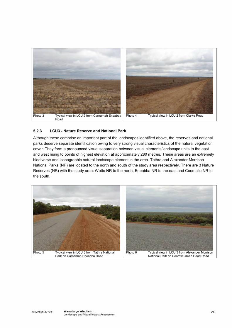
5.2.3 LCU3 - Nature Reserve and National Park
Although these comprise an important part of the landscapes identified above, the reserves and national parks deserve separate identification owing to very strong visual characteristics of the natural vegetation cover. They form a pronounced visual separation between visual elements/landscape units to the east and west rising to points of highest elevation at approximately 280 metres. These areas are an extremely biodiverse and iconographic natural landscape element in the area. Tathra and Alexander Morrison National Parks (NP) are located to the north and south of the study area respectively. There are 3 Nature Reserves (NR) with the study area: Wotto NR to the north, Eneabba NR to the east and Coomallo NR to the south.
Photo 5 Typical view in LCU 3 from Tathra National
Park on Carnamah Eneabba Road
Photo 6 Typical view in LCU 3 from Alexander Morrison
National Park on Coorow Green Head Road

25 61/27826/207081 Warradarge Windfarm Landscape and Visual Impact Assessment
5.3 Sensitive receptors People are mobile and therefore could potentially experience views of the Proposal from many different locations. In order to undertake an assessment of visual impacts, a series of key view locations have been selected to represent the points from which the Proposal is likely to be viewed by the greatest number of visual receptors and /or from where the most sensitive visual receptors are likely to perceive the Proposal.
Representative sensitive receptor locations have been indicated in Appendix A Figure 3 and have been described in Section 5.3.
The viewing locations for which the visual impact of the proposal has been assessed are outlined below:
View location 1 – Eneabba
View location 2 – Tootbardi Road
View location 3 – Chatfield Road
View location 4 – Garibaldi Willis Road
View location 5 – Tathra National Park
View location 6 – Rose Thomson Road
View location 7 – Warradarge
5.3.1 View location 1 – Eneabba
Photo 7 View location 1 - view southeast Darling Street
and Morgan Street, Eneabba
Photo 8 View location 1 - view southeast from Eziway
shop, King Street, Eneabba

26 61/27826/207081 Warradarge Windfarm Landscape and Visual Impact Assessment
Table 8 View location 1 - visual context
Landscape/ visual element
Baseline description
Location At the corner of Darling Street and Morgan Street in Eneabba.
Landform / significant features
Topography is generally flat with the land gently rising in elevation to the east of the town.
Vegetation To the south and east the vegetation is dense thickets of low scrubby plants.
Water There are no rivers or creeks in the immediate area.
Land use and infrastructure
Eneabba has a population of approximately 260 (based on the 2001 census). It is a small rural town with the primary employment coming from the mineral sands mine located to the south. The Dongara Eneabba freight Railway is located to the north of the town and terminates at the mine. Brand Highway which has a north south alignment is located to the west of the town.
Visual context Views are generally dictated by the topography and presence of local vegetation. Vistas range from a short to long distance and are screened/filtered in some directions.
Views in this area are primarily composed of large areas of low vegetation with cleared agricultural farm land in some views.
Views are experienced by residents, road users and tourists on the wildflower drives.

27 61/27826/207081 Warradarge Windfarm Landscape and Visual Impact Assessment
5.3.2 View location 2 – Tootbardi Road
Photo 9 View location 2 - view north northeast from Tootbardi Road
Table 9 View location 2 – visual context
Landscape/ visual element
Baseline description
Location Unpaved road running northeast from Brand highway to Coorow Green Head Road.
Landform / significant features
Topography is gently rolling with the road running along the top of a ridge line at approximately 250 metres. This view location is located on a high point on the road at approximately 274 metres.
Vegetation Primarily cleared agricultural tillage land, with some patches of natural vegetation. Alexander Morrison NP is visible in the distance to the northeast.
Water There are no drainage lines in the immediate vicinity of the view location. There are however some drainage lines with riparian zone and degraded non-wooded drainage lines that run from the ridgeline to the north and south. There are also some small farm dams used for agricultural purposes.
Land use and infrastructure
Primarily cleared agricultural pasture with scattered pockets of taller vegetation.
Sparse distribution of homestead.
Visual context Views are generally dictated by the topography and presence of local vegetation. Vistas are long open to the distance. Views in this area are primarily composed of agricultural land and associated activities/infrastructure, and natural areas of protected vegetation in the national park.
Views of the thick smooth carpet of vegetation in Alexander Morrison NP to the southeast.
There are some residential properties in the vicinity of this location that would experience similar views.
Views are experienced by road users, agricultural workers, tourists on the wildflower drives and residents of the homestead within the area.

28 61/27826/207081 Warradarge Windfarm Landscape and Visual Impact Assessment
5.3.3 View location 3 – Chatfield Road
Photo 10 View location 3 - view southwest from Chatfield Road
Table 10 View location 3 – visual context
Landscape/ visual element
Baseline description
Location Unpaved road with a north south orientation. It connects to Carnamah Eneabba Road in the north joining Clarke and Willmott Road in the south.
Landform / significant features
Topography is gently undulating. This view location is located on a raised plateau at approximately height of 283 metres.
Vegetation Primarily cleared agricultural tillage land, with some patches of natural vegetation.
Water There are no creeks or water lines in the area other than small farm dams used for agricultural purposes.
Land use and infrastructure
Primarily cleared agricultural pasture with scattered pockets of taller vegetation.
Sparse distribution of homestead.
Visual context Views are generally dictated by the topography and presence of local vegetation. Vistas are medium in distance with views restricted along some parts of the road due to roadside vegetation. Views in this area are primarily composed of agricultural land and associated activities/infrastructure, and natural areas of protected vegetation in the national park.
There are some residential properties in the vicinity of this location that would experience similar views.
Views are experienced by road users, agricultural workers, tourists on the wildflower drives and residents of the homestead within the area.

29 61/27826/207081 Warradarge Windfarm Landscape and Visual Impact Assessment
5.3.4 View location 4 – Garibaldi Willis Road
Photo 11 View location 4 - view south/southeast from Garibaldi Willis Road
Table 11 View location 4 – visual context
Landscape/ visual element
Baseline description
Location Unpaved road with a north south orientation. It connects to Carnamah Eneabba Road in the north Coorow Green Head Road in the south.
Landform / significant features
This view location is located on the eastern edge of raised ridgeline plateau at approximately height of 300 metres. Topography is gently undulating with a valley to the northeast.
Vegetation Primarily cleared agricultural tillage land to the south and east, with some patches of natural vegetation. To the west of this location is a dense thicket of low scrubby vegetation.
Water There are no creeks or water lines in the area other than small farm dams used for agricultural purposes.
Land use and infrastructure
Primarily cleared agricultural pasture with scattered pockets of taller vegetation
Uncleared land with dense thickets of low scrubby vegetation,
Sparse distribution of homestead.
Visual context Views are generally dictated by the topography and presence of local vegetation. Vistas are medium to long in distance. Views are restricted along some parts of the road due to thick roadside vegetation. Views in this area are primarily composed of agricultural land and associated activities/infrastructure, and natural areas of vegetation.
There are some residential properties in the vicinity of this location that would experience similar views.
Views are experienced by road users, tourists on the wildflower drives, agricultural workers, and residents of the homestead within the area.
30 61/27826/207081 Warradarge Windfarm Landscape and Visual Impact Assessment
5.3.5 View location 5 – Tathra National Park
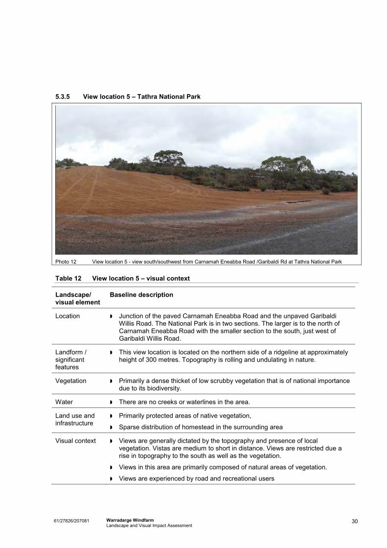
Photo 12 View location 5 - view south/southwest from Carnamah Eneabba Road /Garibaldi Rd at Tathra National Park
Table 12 View location 5 – visual context
Landscape/ visual element
Baseline description
Location Junction of the paved Carnamah Eneabba Road and the unpaved Garibaldi Willis Road. The National Park is in two sections. The larger is to the north of Carnamah Eneabba Road with the smaller section to the south, just west of Garibaldi Willis Road.
Landform / significant features
This view location is located on the northern side of a ridgeline at approximately height of 300 metres. Topography is rolling and undulating in nature.
Vegetation Primarily a dense thicket of low scrubby vegetation that is of national importance due to its biodiversity.
Water There are no creeks or waterlines in the area.
Land use and infrastructure
Primarily protected areas of native vegetation,
Sparse distribution of homestead in the surrounding area
Visual context Views are generally dictated by the topography and presence of local vegetation. Vistas are medium to short in distance. Views are restricted due a rise in topography to the south as well as the vegetation.
Views in this area are primarily composed of natural areas of vegetation.
Views are experienced by road and recreational users

31 61/27826/207081 Warradarge Windfarm Landscape and Visual Impact Assessment
5.3.6 View location 6 – Rose Thomson Road
Photo 13 View location 6 - view southeast from Rose Thomson Road
Table 13 View location 6 – visual context
Landscape/ visual element
Baseline description
Location Unpaved road with a north south orientation. It connects to Carnamah Eneabba Road in the north Coorow Green Head Road in the south.
Landform / significant features
This view location is located on a low ridge at approximately height of 235 metres. Topography is gently undulating with a valley to the east.
Vegetation Primarily cleared agricultural tillage land, with some patches of natural vegetation.
Thick band of road side vegetation.
Water There is a river valley to the east running in a north south direction. The river has many small tributes flowing onto it from the surrounding area.
Land use and infrastructure
Primarily cleared agricultural pasture with scattered pockets of taller vegetation
Uncleared dense thickets of low scrubby roadside vegetation,
Sparse distribution of homestead.
Visual context Views are generally dictated by the topography and presence of local vegetation. Vistas are medium to long in distance. Views are restricted along some parts of the road due to thick roadside vegetation. Views in this area are primarily composed of agricultural land and associated activities/infrastructure, and natural areas of vegetation.
There are some residential properties in the vicinity of this location that would experience similar views.
Views are experienced by road users, agricultural workers, tourists on the wildflower drives and residents of the homestead within the area.

32 61/27826/207081 Warradarge Windfarm Landscape and Visual Impact Assessment
5.3.7 View location 7 – Warradarge
Photo 14 View location 7 - view northeast from Halfway Road House and camping facility
Table 14 View location 7 – visual context
Landscape/ visual element
Baseline description
Location Located just off the Brand highway at the junction with Coorow-Green Road. This area consists of the Halfway Mill Roadhouse, the Bush Fire Brigade Station and meeting room. There is also a small area of a caravan park beside the roadhouse.
Landform / significant features
This view location is located in the lower region of the study area at approximately height of 171 metres. It is situated in a creek valley. The topography is undulating with higher areas to the east.
Vegetation Primarily cleared agricultural tillage land to the east and north, with some patches of natural vegetation. To the west of this location the vegetation is a dense thicket of low scrubby vegetation.
Water Drainage lines with riparian zone and degraded non-wooded drainage lines that run from the ridgeline to the north and south.
Land use and infrastructure
Primarily cleared agricultural pasture with scattered pockets of taller vegetation.
Petrol Station with associated infrastructure and services.
Bush Fire Brigade Station
Visual context Views are generally dictated by the topography and presence of local vegetation. Vistas are medium distance. Views are restricted in some parts due
33 61/27826/207081 Warradarge Windfarm Landscape and Visual Impact Assessment
Landscape/ visual element
Baseline description
to thick roadside vegetation.
Views in this area are primarily composed of agricultural land and associated activities/infrastructure, and natural areas of vegetation.
Views are experienced by road users, tourists on the wildflower drives, agricultural workers, customers and employees of the roadhouse and users of the caravan park facility.
Users of the Bush Fire Brigade Station community meeting room.

34 61/27826/207081 Warradarge Windfarm Landscape and Visual Impact Assessment
6. Impact Assessment
6.1 Introduction
The potential visual impacts are considered within the context of the sensitivity of the surrounding visual environment and the potential for viewing of the areas that have had changes to their visual outlook due to site works and operational requirements. The assessment of potential visual impacts as a result of the proposal focuses on the visibility of both the construction and operation phases.
The key visible components of the proposal that may give rise to landscape and visual effects during the construction phase during daylight hours would include:
Site compound (site offices, amenity facilities, equipment storage, fencing, signage).
Construction vehicle and employee movements (on site).
Construction workers travelling to and from work.
Temporary road closures and/or diversions and associated signage
Unsealed access tracks.
Concrete batching plant.
Delivery and erection of plant and equipment.
Crane and erection of turbines and overhead power line
Excavation works and foundation establishment (both turbines and overhead power lines).
Site and some vegetation clearance.
Soil stockpiling.
Whilst wind turbines and overhead power lines are likely to be the most visible component of the proposal, other visible ancillary structures during the operation phase during daylight hours may include:
An internal network of unsealed access roads.
Maintenance operations, vehicle and employee movements.
Three guyed anemometer masts.
Electrical substation.
The landscape and visual impacts as seen from the viewing locations as described in Section 5 above have been assessed for both construction and operational phases in the following sections. As discussed in Section 5 above, these viewing locations are representative of the potential landscape and visual issues within the 25 km study area.
This report is not a summary of every potential landscape and visual impact associated with the construction and operation of the proposal, but a representation of the various effects that may arise at different publically accessible locations. Generally, these will be short term, phased impacts during the construction phase of the proposal. These impacts will reduce in significance over time in the operational phase as new elements become part of the existing view.

35 61/27826/207081 Warradarge Windfarm Landscape and Visual Impact Assessment
Viewing locations assessed include (Refer Appendix A, Figure 3 and Appendix B Photomontages):
View location 1 - Eneabba
View location 2 – Tootbardi Road
View location 3 – Chatfield Road
View location 4 – Garibaldi Willis Road
View location 5 – Tathra National Park
View location 6 – Rose Thomson Road
View location 7 – Warradarge
General mitigation recommendations for landscape and visual management have also been discussed in Section 7 below, in response to the impact assessment.
View location 1 – Eneabba (refer Appendix A, Figure 3 and Appendix B, photomontage location 1)
Visible
Proposal Elements
Haulage vehicles moving materials/equipment/plant to and from the site on trucks via the local road network and any associated airborne dust.
Temporary road closures and/or diversions and associated signage.
Construction workers travelling to and from work.
Top of crane and erection of turbines and overhead power lines.
Wind turbines.
Maintenance vehicles accessing the site via the local road network and any associated airborne dust.
Landscape and Visual Impacts - Construction Phase
Due to the distance from the construction site (approximately 22 km), residential receptors, tourists and road users would generally experience short term and distant views of the erection of the turbines.
The key impact from this viewing location would be indirect via the introduction of new scenes of large transport vehicles utilising the local road network causing disruption to the existing amenity. These effects would be short term, phased and adverse, and viewed within the context of the existing road and freight rail network/movements, as a result of dust and visual intrusion caused by:
Haulage vehicles moving materials/equipment/plant to and from the site.
Construction workers travelling to and from work.
Temporary Road closures and/or diversions and associated signage.
The construction works would also have an adverse effect on the setting of the „wildflower drives‟ resulting in reduced amenity due to dust and visual
36 61/27826/207081 Warradarge Windfarm Landscape and Visual Impact Assessment
intrusion.
Effects would be experienced from residential properties with long viewing opportunities, by tourists on „wildflower drives‟ with an interest in their environment and by road users passing through. However, views would be transient and short term in nature.
The area viewed from location 1 is described in Section 5 above as LCU 1. It has a low sensitivity due to the largely modified (largely cleared farming landscape) nature, and a medium potential capacity to absorb change due to its scale (i.e. extensive openness, low vegetation, generally flat topography large tracts of agricultural land). Overall the proposal is assessed as having a negligible landscape impact on this view location due to distance from the site and generally flat topography. The proposal is assessed as having a neutral impact as it will neither enhance nor detract from the landscape character and view in this area.
The visual amenity of receptors would be indirectly and adversely affected primarily due to the increased presence of oversize construction vehicles, and construction activities viewed at a distance. Receptors are assessed as having a medium visual sensitivity due to residence‟s long viewing periods at a distance from the construction site.
Using the matrix (Table 7) the predicted construction period impacts have been assessed as short term and not significant.
Landscape and Visual Impacts - Operation Phase
Generally speaking turbines will not be visible from this location. There may be potential for filtered distant (22 km) views from some locations in Eneabba for residents and tourists.
Existing low foreground vegetation would act to filter/intervene between the viewer and the turbines.
Impacts would reduce over time as the above ground elements become part of the view.
The proposal is assessed as having a neutral impact as it will neither enhance nor detract from the landscape character and view in this area.
It is therefore assessed as having a negligible landscape impact and medium visual sensitivity during operation.
The predicted operational impacts as a direct result of this proposal have been assessed as long term and not significant.

37 61/27826/207081 Warradarge Windfarm Landscape and Visual Impact Assessment
View location 2 – Tootbardi Road (refer Appendix A, Figure 3 and Appendix B, photomontage location 2)
Visible
Proposal Elements
Haulage vehicles moving materials/equipment/plant to and from the site on trucks via the local road network and any associated airborne dust.
Temporary road closures and/or diversions and associated signage.
Construction workers travelling to and from work.
Top of crane and erection of turbines and overhead power lines.
Wind turbines.
Overhead power lines.
Landscape and Visual Impacts - Construction Phase
Due to the distance from the construction site (approximately 17 km), residential receptors, tourists, road users and agricultural workers would generally experience short term and distant views of the erection of the turbines and overhead power lines.
The key impact from this viewing location would be indirect via the introduction of new scenes of large transport vehicles utilising the local road network causing disruption to the existing amenity. These effects would be short term, phased and adverse, but viewed within the context of the existing road and freight rail network/movements in the local area, and agricultural cropping (i.e. generates dust) as a result of dust and visual intrusion caused by:
Haulage vehicles moving materials/equipment/plant to and from the site, and between different construction areas on site.
Construction workers travelling to and from work, and moving between different areas of the site.
Temporary road closures and/or diversions and associated signage.
The construction works would also have an adverse effect on the setting of the „wildflower drives‟ and conservation areas national parks and would result in reduced amenity due to dust and visual intrusion.
Effects would be experienced from residential properties with long viewing opportunities, however although this viewpoint is elevated topographically, views of the site would be distant, foreground vegetation/patterned broad acre cropping. Tourists on „wildflower drives‟ with an interest in their environment and by road users passing through would have transient and short term in nature. Agricultural workers with a focus on their work would have intermittent views, in part filtered by foreground vegetation.
The area viewed from location 2 is described in Section 5 above as LCU 2. It has a low sensitivity due to the largely modified (cleared farming landscape)
38 61/27826/207081 Warradarge Windfarm Landscape and Visual Impact Assessment
nature, and a medium potential capacity to absorb change due to its scale (i.e. extensive openness, low vegetation, changes in topographical relief, large tracts of agricultural land). Overall the proposal is assessed as having a moderate landscape impact primarily due to the introduction of tall vertical elements into the existing setting. The proposal is assessed as having a negative impact as it will reduce and have an adverse effect on the existing landscape character and view
The visual amenity of receptors would be indirectly and adversely affected primarily due to the increased presence of oversize construction vehicles, and construction activities viewed from a distance. Receptors are assessed as having a medium visual sensitivity due to residence‟s long viewing periods at a distance from the construction site.
Using the matrix (Table 7) the predicted construction period impacts have been assessed as short term and of moderate significance.
Landscape and Visual Impacts - Operation Phase
Key impacts during operation would be the addition of overhead power lines and turbines reaching over the skyline, visible from a distance, and the infrequent use of the local road network by maintenance vehicles accessing the site.
Due to the viewing distance (17 km) from the site, when viewed together, all turbines form an irregular group with varying spacing between. The overlapping and differing extent of visibility of each turbine causes some visual confusion. Additionally, the turbines will appear to be spread out and disappear behind the varying topographical relief. The visibility of the turbines also will vary greatly, depending on the weather conditions, as they are seen against the sky.
Existing low foreground vegetation, varying topographical relief, wind breaks, would create act to intervene between the viewer and the turbines.
The turbines will not form a dominant focus for views from this location, in part due to distance from the site and intervening vegetation. The scale and character of the landscape is not overly compromised, as the character is that of a highly modified landscape and therefore is more capable of visually absorbing developments such as wind turbines than more “untouched” or “pristine” types of landscape. As such, landscape sensitivity and capacity to absorb change would remain the same as that described above in construction phase.
The proposals would have a long term adverse effect on the setting of the „wildflower drives‟ and conservation areas national parks and would result in reduced amenity due to visual intrusion.
The proposed substation will not be visible in this view.
Key receptors would be residents with long viewing periods, road users passing through with transient views, tourists on the „wildflower drives‟ with a focus on their environment and agricultural workers with a focus on their

39 61/27826/207081 Warradarge Windfarm Landscape and Visual Impact Assessment
activity.
Impacts would reduce over time as the above ground elements become part of the view.
The proposal is assessed as having a negative impact as it will reduce and have an adverse effect on the existing landscape character and view.
It is therefore assessed as having a small landscape impact and medium visual sensitivity during operation.
The predicted operational period impacts as a direct result of this proposal have been assessed as long term and of minor significance.
View location 3 – Chatfield Road (refer Appendix A, Figure 3 and Appendix B, photomontage location 3)
Visible
Proposal Elements
Medium distance views of haulage vehicles moving materials/equipment/plant to and from the site on trucks via the local road network and any associated airborne dust.
Temporary road closures and/or diversions and associated signage.
Construction workers travelling to and from work.
Delivery and erection of turbines, and anemometer mast.
Crane and large construction vehicles moving about the site.
Construction compound and concrete batching plant.
Wind turbines.
Anemometer masts.
Large maintenance vehicles accessing the site via the local road network and any associated airborne dust.
Landscape and Visual Impacts - Construction Phase
Although still at some distance from the construction site (approximately 10 km), residential receptors, road users, tourists and agricultural workers would experience direct impacts. Disruption to the existing amenity would comprise distant views of large construction elements only including the erection of the turbines, the construction compound, batching plant and large vehicle movements and associated dust both on site and by large transport vehicles utilising the local road network.
Impacts would be short term, phased and adverse, but viewed within the context of the existing road network/movements and agricultural activities (e.g. cropping generating dust) in the local area, as a result of dust and visual
40 61/27826/207081 Warradarge Windfarm Landscape and Visual Impact Assessment
intrusion caused by:
Haulage vehicles moving materials/equipment/plant to and from the site, and between different construction areas on site.
Construction workers travelling to and from work, and moving between different areas of the site.
Temporary road closures and/or diversions and associated signage.
General construction activities, particularly at the site entry, compound and batching plant off Garibaldi Willis Road and during the erection of turbines to the north-eastern corner of the site.
The construction works would also have an adverse effect on the setting of the „wildflower drives‟ resulting in reduced amenity due to dust and visual intrusion.
Effects would be experienced from residential properties with long viewing opportunities, however although this viewpoint is elevated topographically, views of the site would be distant and in part screened by roadside vegetation and foreground vegetation/patterned broad acre cropping. Tourists on „wildflower drives‟ with an interest in their environment and road users passing through would have views that are transient and short term in nature. Agricultural workers with a focus on their work would have intermittent views, in part filtered by foreground vegetation.
The area viewed from location 3 is described in Section 5 above as LCU 2. It has a low sensitivity due to the largely modified (cleared farming landscape) nature, and a medium potential capacity to absorb change due to its scale (i.e. extensive openness, low vegetation, changes in topographical relief, large tracts of agricultural land). Overall the proposal is assessed as having a moderate landscape impact primarily due to the introduction of tall vertical elements, construction compound and batching plant into the existing setting. The proposal is assessed as having a negative impact as it will reduce and have an adverse effect on the existing landscape character and view
The visual amenity of receptors would be indirectly and adversely affected primarily due to the increased presence of oversize construction vehicles, and construction activities viewed from a distance. Receptors are assessed as having a medium visual sensitivity due to residence‟s long viewing periods at a distance from the construction site.
Using the matrix (Table 7) the predicted construction period impacts have been assessed as short term and of moderate significance.
Landscape and Visual Impacts - Operation Phase
Key impacts during operation would be the addition of turbines reaching over the skyline, visible from a distance, and the infrequent use of the local road network by maintenance vehicles accessing the site.
Due to the viewing distance (10 km) from the site, when viewed together, all turbines form an irregular group with varying spacing between. The

41 61/27826/207081 Warradarge Windfarm Landscape and Visual Impact Assessment
overlapping and differing extent of visibility of each turbine causes some visual confusion. Additionally, the turbines will appear to be spread out and disappear behind the varying topographical relief in the southern site extents. The visibility of the turbines also will vary greatly, depending on the weather conditions, as they are seen against the sky.
Existing low foreground and roadside vegetation and varying topographical relief would act to filter/intervene between the viewer and the turbines.
The proposals would have a long term adverse effect on the setting of the „wildflower drives‟ and would result in reduced amenity due to visual intrusion.
The turbines will form a focus in some views from this location, in part due to distance from the site and intervening vegetation. The scale and character of the landscape is not overly compromised, as the character is that of a highly modified landscape and therefore is more capable of visually absorbing developments such as wind turbines than more “untouched” or “pristine” types of landscape. As such, landscape sensitivity and capacity to absorb change would remain the same as that described above in construction phase.
The proposed substation will not be visible in this view.
Key receptors would be residents with long viewing periods, road users passing through with transient views, tourists on the „wildflower drives‟ with a focus on their environment and agricultural workers with a focus on their activity.
Impacts would reduce over time as the above ground elements become part of the view.
The proposal is assessed as having a negative impact as it will reduce and have an adverse effect on the existing landscape character and view
It is therefore assessed as having a moderate landscape impact and medium visual sensitivity during operation.
The predicted operational period impacts as a direct result of this proposal have been assessed as long term and of moderate significance.
42 61/27826/207081 Warradarge Windfarm Landscape and Visual Impact Assessment
View location 4 – Garibaldi Willis Road (refer Appendix A, Figure 3 and Appendix B, photomontage location 4)
Visible
Proposal Elements
Construction vehicles and workers accessing the site via the local road network, any associated airborne dust.
Access roads from Garibaldi Willis road and throughout the site.
Delivery and erection of turbines, overhead power lines and anemometer mast.
Crane and large construction vehicles moving about the site.
Construction compound and concrete batching plant and associated infrastructure/elements.
General construction activities (e.g. excavating, soil stock piles) and workers on site.
Wind turbines.
Anemometer masts.
Access roads.
Substation.
Maintenance vehicles accessing the site via the local road network and on site, any associated airborne dust.
Landscape and Visual Impacts - Construction Phase
Close views (approximately 4 km) of direct impacts would be afforded by residential receptors, road users, tourists and agricultural workers.
Disruption to the existing amenity/visual intrusion would result from views of all construction activities (including delivery and erection).
Impacts would be short term, phased and adverse.
The construction works would also have an adverse effect on the setting of the „wildflower drives‟ resulting in reduced amenity due to dust and visual intrusion.
Effects would be experienced from residential properties with long viewing opportunities, but in part screened or filtered by roadside vegetation and some foreground vegetation. Tourists on „wildflower drives‟ with an interest in their environment and road users passing through would have views that are transient and short term in nature. Agricultural workers with a focus on their work would have intermittent views, in part filtered by foreground vegetation.
The area viewed from location 4 is described in section 5 above as LCU 2. It has a low sensitivity due to the largely modified (cleared farming landscape) nature, and a medium potential capacity to absorb change due to its scale (i.e. extensive openness, low vegetation, changes in topographical relief,
43 61/27826/207081 Warradarge Windfarm Landscape and Visual Impact Assessment
large tracts of agricultural land). Overall the proposal is assessed as having a large landscape impact primarily due to the introduction of tall vertical elements, construction compound, anemometer masts and batching plant into the existing setting. The proposal is assessed as having a negative impact as it will reduce and have an adverse effect on the existing landscape character and view
The visual amenity of receptors would be directly and adversely affected primarily due to the presence of construction activities and new built form. Receptors are assessed as having a high visual sensitivity due to residence‟s long viewing periods viewed from a close distance to the construction site.
Using the matrix (Table 7) the predicted construction period impacts have been assessed as short term and of major significance.
Landscape and Visual Impacts - Operation Phase
Key impacts during operation would be the addition of turbines (some turbines will be fully visible), a substation, unsealed access roads and the infrequent use of the local road network by maintenance vehicles accessing the site.
This view represents the potential visual impact on a number of views along the Garibaldi Willis Road, when approaching the proposed site from the north or south, many within 5 km of the site.
Most turbines will be fully visible. Generally, the turbines would be seen as a cohesive group spaced out at regular distances and have a visual relationship with the topography, resulting in visual clarity. However, seven turbines to the north-east corner of the site, when viewed from this direction, display increasing gaps between turbines, distort the cohesiveness of the group further west and do not relate to the existing topography.
Generally, however, the overlapping and differing extent of visibility of each turbine causes some visual confusion. Additionally, the turbines will appear to be spread out and reduce in scale behind the varying topographical relief to the northern site extents. The visibility of the turbines also will vary, depending on the weather conditions, as they are seen against the sky.
Due to the close proximity of the views, and large scale of the proposals, screening is not possible.
The proposals would have a long term adverse effect on the setting of the „wildflower drives‟ and would result in reduced amenity due to visual intrusion.
The turbines will be the largest elements in this landscape. They will be a dominant focus for views in this direction. However, the scale and character of the landscape is not overly compromised. This landscape has been shaped by humans, which is evident from the agricultural cropping, geometrical shapes of the paddock boundaries and existing road network. This type of landscape is more capable of visually absorbing developments such as wind turbines than more “untouched” or “pristine” types of landscape. As such, landscape sensitivity and capacity to absorb change would remain the same
44 61/27826/207081 Warradarge Windfarm Landscape and Visual Impact Assessment
as that described above in construction phase.
Key receptors being residents with long viewing periods, road users passing through with close but transient views, tourists on the „wildflower drives‟ with a focus on their environment, maintenance workers on site and agricultural workers with a focus on their activity.
Impacts would reduce over time as the above ground elements become part of the view.
The proposal is assessed as having a negative impact as it will reduce and have an adverse effect on the existing landscape character and view
It is therefore assessed as having a large landscape and medium visual sensitivity during operation.
The predicted operational period impacts as a direct result of this proposal have been assessed as long term and of high significance.

45 61/27826/207081 Warradarge Windfarm Landscape and Visual Impact Assessment
View location 5 – Tathra National Park (refer Appendix A, Figure 3 and Appendix B, photomontage location 5)
Visible
Proposal Elements
Haulage vehicles moving materials/equipment/plant to and from the site on trucks via the local road network and any associated airborne dust.
Temporary road closures and/or diversions and associated signage.
Construction workers travelling to and from work.
Top of crane and erection of turbines and overhead power lines.
Wind turbines.
Maintenance vehicles accessing the site from the local road network.
Landscape and Visual Impacts - Construction Phase
Due to the distance from the construction site (approximately 14 km), recreational and road users experience short term and distant views of the erection of the turbines.
The key impact from this viewing location would be indirect via the introduction of new scenes of large transport vehicles utilising the local road network causing disruption to the existing amenity. These effects would be short term, phased and adverse, but viewed within the context of the existing road network/movements in the local area generated as a result of dust and visual intrusion caused by:
Haulage vehicles moving materials/equipment/plant to and from the site, and between different construction areas on site.
Construction workers travelling to and from work, and moving between different areas of the site.
Temporary road closures and/or diversions and associated signage.
The construction works would also have an adverse effect on the setting of the „wildflower drives‟ and recreational experience of the Tathra National Park to its margins resulting in reduced amenity due to dust and visual intrusion.
Views to the site itself will be restricted due to distance, undulating topography including a rise in topography south of the view location and presence of dense thicket vegetation in the foreground of the southern section of the Tathra National Park.
Tourists on „wildflower drives‟ with an interest in their environment and by road users passing through would have transient and short term in nature.
The area viewed from location 5 is described in Section 5 above as LCU 3. It has a medium sensitivity due to their rarity within the region, iconic nature, value locally and contribution to the landscape through the contrast of natural vegetation cover and adjacent land uses. As such, this LCU has a low potential capacity to absorb change. Overall, during the construction phase it

46 61/27826/207081 Warradarge Windfarm Landscape and Visual Impact Assessment
is assessed as having a moderate landscape impact primarily due to vehicular movements. The proposal is assessed as having a negative impact as it will reduce and have an adverse effect on the existing landscape character and view
The visual amenity of receptors would be indirectly and adversely affected primarily due to the increased presence of oversize construction vehicles, and construction activities viewed from a distance. Receptors are assessed as having a medium visual sensitivity primarily due to recreation users‟ interest in their local environment.
Using the matrix (Table 7) the predicted construction period impacts have been assessed as short term and of moderate significance.
Landscape and Visual Impacts - Operation Phase
The key impacts during operation would be the addition of turbines reaching over the skyline, which may be visible from this viewing location, and the infrequent use of the local road network by maintenance vehicles accessing the site.
Due to the viewing distance (14 km) from the site, when viewed together, all turbines will form an irregular group with varying spacing between. The overlapping and differing extent of visibility of each turbine will cause some visual confusion. Additionally, the turbines will disappear behind the varying topographical relief. The visibility of the turbines also will vary greatly, depending on the weather conditions, as they are seen against the sky.
The turbines will not form a dominant focus within views from this location due to distance, existing dense foreground vegetation and the topographical relief rising to the south which would act to filter/intervene views between the user and the turbine. However, the proposals would have a long term adverse effect on the setting to the „wildflower drives‟ and the Tathra National Park, resulting in reduced amenity due to visual intrusion.
The scale of the landscape will not be overly compromised. However, the unique character as a „natural areas‟ of LCU 3 is less capable of visually absorbing developments such as wind turbines than more modified landscapes such as adjacent agricultural land. As such, landscape sensitivity and capacity to absorb change would remain the same as that described above in construction phase.
The proposed substation will not be visible in this view.
Key receptors would be road users passing through with transient views and recreation users on the „wildflower drives‟/utilising the Tathra National Park with a focus on the natural environment.
Impacts would reduce over time as the above ground elements become part of the view.
The proposal is assessed as having a negative impact as it will reduce and have an adverse effect on the existing landscape character and view

47 61/27826/207081 Warradarge Windfarm Landscape and Visual Impact Assessment
It is therefore assessed as having a moderate landscape impact and low visual sensitivity during operation.
The predicted operational period impacts as a direct result of this proposal have been assessed as long term and of minor significance.
View location 6 – Rose Thomson Road (refer Appendix A, Figure 3 and Appendix B, photomontage location 6)
Visible
Proposal Elements
Haulage vehicles moving materials/equipment/plant to and from the site on trucks via the local road network and any associated airborne dust.
Temporary road closures and/or diversions and associated signage.
Construction workers travelling to and from work.
Crane and large construction vehicles moving about the site.
Construction compound and concrete batching plant and associated infrastructure/elements.
Access roads throughout the site.
General construction activities (e.g. excavating, soil stock piles) and workers on site.
Wind turbines.
Overhead power lines.
Anemometer masts.
Access roads.
Substation.
Maintenance vehicles accessing the site via the local road network and on site, any associated airborne dust.
Landscape and Visual Impacts - Construction Phase
Medium distance views (approximately 9 km to nearest turbines and 850 m to the nearest overhead power line pylon) of direct impacts would be afforded by residential receptors, road users, tourists and agricultural workers.
Disruption to the existing amenity/visual intrusion would result from views of all construction activities (including delivery and erection).
Impacts would be short term, phased and adverse.
The construction works would also have an adverse effect on the setting of the „wildflower drives‟ resulting in reduced amenity due to dust and visual intrusion.
Effects would be experienced from residential properties with long viewing

48 61/27826/207081 Warradarge Windfarm Landscape and Visual Impact Assessment
opportunities, but in part screened or filtered by roadside vegetation and some foreground vegetation. Tourists on „wildflower drives‟ with an interest in their environment and road users passing through would have views that are close, transient and short term in nature. Agricultural workers with a focus on their work would have intermittent views, in part filtered by foreground vegetation.
The area viewed from location 6 is described in Section 5 above as LCU 1. It has a low sensitivity due to the largely modified (largely cleared farming landscape) nature, and a medium potential capacity to absorb change due to its scale (i.e. extensive openness, low vegetation, generally flat topography large tracts of agricultural land). Overall it is assessed as having a moderate landscape impact primarily due to the introduction of turbines and overhead power lines into the existing setting. The proposal is assessed as having a negative impact as it will reduce and have an adverse effect on the existing landscape character and view
The visual amenity of receptors would be directly and adversely affected primarily due to the presence of construction activities and new built form. Receptors are assessed as having a high visual sensitivity due to residence‟s long viewing periods viewed from a close distance to the construction site.
Using the matrix (Table 7) the predicted construction period impacts have been assessed as short term and of high significance.
Landscape and Visual Impacts - Operation Phase
Key impacts during operation would be the addition of overhead power lines and turbines, a substation and unsealed access roads and maintenance vehicles on site.
This view represents the potential visual impact on a number of views along the Rose Thomson Road, when approaching the proposed site from the north or south, many within 5 km of the site.
Generally, the overhead power lines/pylons and turbines will be fully visible. The foreground view will be dominated by the overhead powerline pylons with the turbines in the background (but still highly visible). Generally, the overlapping and differing extent of visibility of each turbine and pylon will cause some visual confusion. Additionally, the turbines will appear to be spread out and reduce in scale behind the varying topographical relief to the southern site extents. The visibility of the turbines and pylons will also vary, depending on the weather conditions, as they are seen against the sky.
The overhead powerlines to the north west corner of the site, when viewed from this direction will display regular but wide gaps between pylons, and to some extent will distort the cohesiveness of the combined group of turbines and pylons together. However, the overhead powerlines will be viewed within the context of existing similar infrastructure (330 kV adjacent powerline running in a general north-south direction) in the local area.
Due to the medium distance proximity of the views, and large scale of the

49 61/27826/207081 Warradarge Windfarm Landscape and Visual Impact Assessment
proposals, screening is not possible.
The proposals would have a long term adverse effect on the setting of the „wildflower drives‟ and would result in reduced amenity due to visual intrusion.
The turbines and pylons will be the largest elements in this landscape. They will be a dominant focus for views in this direction. However, the scale and character of the landscape will not be overly compromised. This landscape has been shaped by humans, which is evident from the agricultural cropping, geometrical shapes of the paddock boundaries, existing road network and power infrastructure. This type of landscape is more capable of visually absorbing developments such as wind turbines than more “untouched” or “pristine” types of landscape. As such, landscape sensitivity and capacity to absorb change would remain the same as that described above in construction phase.
The proposed substation may be visible in this view but will have minimal visual impact due to the presence of intervening vegetation, and the existing and proposed pylons in the foreground and the substation‟s distance from the view location.
Key receptors would be residents with long viewing periods, road users passing through with close but transient views, tourists on the „wildflower drives‟ with a focus on their environment, maintenance workers on site and agricultural workers with a focus on their activity.
Impacts would reduce over time as the above ground elements become part of the view.
The proposal is assessed as having a negative impact as it will reduce and have an adverse effect on the existing landscape character and view
It is therefore assessed as having a moderate landscape impact and medium visual sensitivity during operation.
The predicted operational period impacts as a direct result of this proposal have been assessed as long term and of moderate significance.

50 61/27826/207081 Warradarge Windfarm Landscape and Visual Impact Assessment
View location 7 – Warradarge (refer Appendix A, Figure 3 and Appendix B, photomontage location 7)
Visible
Proposal Elements
Haulage vehicles moving materials/equipment/plant to and from the site on trucks via the local road network and any associated airborne dust.
Temporary road closures and/or diversions and associated signage.
Construction workers travelling to and from work.
Maintenance vehicles accessing the site via the local road network and any associated airborne dust.
Landscape and Visual Impacts - Construction Phase
View location 7 is approximately 15 km from the construction site and located within a creek valley with higher topography and screening vegetation to the east. Tourists, road users, customers and employees of the roadhouse and caravan park, and Bush Fire Brigade Station would generally only experience indirect impacts via the introduction of new scenes of large transport vehicles utilising the local road network, causing disruption to the existing amenity. The construction site itself would not be seen. Impacts would be short term, phased and adverse, and viewed within the context of the existing road and freight rail network/movements, as a result of dust and visual intrusion caused by:
Haulage vehicles moving materials/equipment/plant to and from the site, and between different construction areas on site.
Construction workers travelling to and from work, and moving between different areas of the site.
Temporary road closures and/or diversions and associated signage.
The construction works would also have an adverse effect on the setting of the „wildflower drives‟ resulting in reduced amenity due to dust and visual intrusion.
The area viewed from location 7 is described in Section 5 above as LCU 1. It has a low sensitivity due to the largely modified (largely cleared farming landscape) nature, and a medium potential capacity to absorb change due to its scale (i.e. extensive openness, low vegetation, generally flat topography large tracts of agricultural land). Overall it is assessed as having a small landscape impact primarily due to construction traffic movements. The proposal is assessed as having a neutral impact as it will neither enhance nor detract from the landscape character and view in this area.
The visual amenity of receptors would be indirectly and adversely affected primarily due to the increased presence of oversize construction vehicles. However, these impacts would be viewed in the context of the existing Brand Highway. Receptors are assessed as having a low visual sensitivity due to

51 61/27826/207081 Warradarge Windfarm Landscape and Visual Impact Assessment
residence‟s long viewing periods at a distance from the construction site.
Using the matrix (Table 7) the predicted construction period impacts have been assessed as short term and not significant.
Landscape and Visual Impacts - Operation Phase
The proposal site will not be visible from this location during operation.
It is therefore assessed as having a negligible landscape impact and neutral visual sensitivity during operation.
The proposal is assessed as having a neutral impact as it will neither enhance nor detract from the landscape character and view in this area.
As there are no predicted operational period impacts from this view location the proposal has been assessed as long term and of not significant.
6.2 Cumulative Impacts There are two known wind farms (one proposed and one operational) potentially within viewing distance of the proposed Warradarge Wind Farm site (Appendix A, Figure 7). These are anticipated to comprise:
Badgingarra Wind Farm, proposed, 65 turbines and is approximately 39 km south of Warradarge Wind Farm, and;
Emu Downs Wind Farm, operational, consisting of 48 turbines and is approximately 54 km south of Warradarge Wind Farm.
A ZTV has been generated to determine potential locations where these wind farms may have visibility that over laps.
Due to distance there is no overlap of potential visibility between Emu Downs Wind Farm and Warradarge Wind Farm. The cumulative impact is therefore considered to be negligible between Warradarge Wind Farm and Emu Downs Wind Farm.
The ZTV (Appendix A, Figure 7) indicates the visibility of the proposed 100 turbines at Warradarge Wind Farm and the proposed 65 turbines at Badgingarra Wind Farm that may be visible from any point in the surrounding area. There is one potential small area from where both proposals may be potentially visible. This zone is at a distance of between 20 – 25 km from both wind farms in the vicinity of Tootbardi Road. While there is potentially visibility of both wind farms in this zone, there is limited crossover where both would be visible from the same location. This is due to the presence of a ridge line to the south of Tootbardi Road which is visible on Figure 2 and has an approximate height of 260 – 290 m AHD. To the north of the ridge primarily only Warradrage Wind Farm would be potentially visible in limited areas and to the south of the ridge only Badgingarra Wind Farm would be potentially visible in limited areas.
The cumulative impact is therefore considered to be negligible between Warradarge Wind Farm and Badgingarra Wind Farm as the potentially for intervisibility between the wind farms would be extremely restricted by the local topography.
52 61/27826/207081 Warradarge Windfarm Landscape and Visual Impact Assessment
7. Mitigation
The management of landscape and visual adverse impacts is to be addressed according to the hierarchy of avoidance, reduction and remedy throughout an iterative design process, construction and operation phases.
7.1 Construction General mitigation measures would reduce and manage adverse impacts of construction work upon landscape and visual amenity may include:
Any existing trees and vegetation to be retained should be protected prior to construction commencement.
Temporary hoardings, barriers, traffic management and signage would be removed when no longer required.
Work on site would be restricted to agreed working daytime working hours wherever possible.
Lighting of compounds and works sites would be restricted to agreed working hours and that which are necessary for security.
Contractors‟ compounds would be located away from residential areas/residences wherever possible.
Roads providing access to site compounds and works areas would be maintained free of dust and mud as far as reasonably practicable.
Upon completion of construction, all remaining spoil and construction materials would be re-used on site or removed to a suitable location.
7.2 Operation General mitigation strategies have been proposed below, given that the siting layout and design are yet to be finalised at the time of writing this report. Such measures have been observed through reference to similar proposals and research.
Wind turbines are by their nature highly visible elements and cannot be easily screened. Their function dictates that they are located on exposed sites. In this case, it is difficult to utilise the generally flat to undulating topography of the site to screen the development from sensitive viewpoints.
Mitigation measures were considered at the initial stages of planning for the layout and design of the turbines.
General Principles The principle objectives for the layout should include:
A wind farm possesses visual relationships between each turbine, in addition to the landscape as a collective group. This relationship must appear clear and simple in order for a development to seem rational and visually unified.
Minimisation of visual confusion.

53 61/27826/207081 Warradarge Windfarm Landscape and Visual Impact Assessment
Turbines and the landscape need to form a coherent unit, achieve balance and avoid visual confusion.
Consider physical, social and experiential and visual characteristics of the surrounding landscape.
The location and design of a wind farm should relate to the key characteristics of the landscape.
Where possible the size of wind turbines should relate to the scale of the surrounding landscape, as well as to the design of the wind farm group, so that they do not appear intimidating.
The spacing of turbines should be relatively regular.
Permanent built elements (e.g. substation) are to be fenced in with materials that are not visually dominant and screened if possible with indigenous planting to the perimeter.
The size of the wind farm is confined and the arrangement of the turbines is to be related to the landform and is to avoid existing native vegetation wherever possible. Whilst the turbines have a presence within the immediate principal visual zone, the scale of the development should not destroy the spatial relationships of the landscape.
Design of Site Access Roads The overall length of road required to access the turbines during construction and maintenance
should be minimised.
Avoidance of significant cut should be achieved by following the site contours rather than crossing the contours.
Excavated material removed during the road construction would be temporarily stockpiled and used to regrade the edges of the road to minimise scarring, where possible.
Siting, Design and Layout of Construction Compound, Substation and Anemometer Masts The construction compound will be located to the north eastern area and the substation will be
located to the north west of the site in order to be less visible from sensitive viewpoints.
Security fencing around the perimeter of the compound should not be visually dominant .
The anemometer masts should be located within the wind farm site. The support structure should ideally comprise a metal lattice framework to decrease visibility from viewpoints close to the site. In distant views the mast will be imperceptible.
Colour The turbines in the majority of views would be seen against the sky. It is proposed to paint them a matt pale grey as this colour acknowledges the man made and sculptural image of wind turbines. The quality of grey also means that, whatever the weather conditions or nature of the surrounding landscape characteristics, the turbines would not aesthetically clash in colour.
Taking into consideration the weather conditions of the site, a darker colour other than pale grey, would make the turbines appear dirty and industrial in character. They would also be more visible against the sky.
Decommissioning and Restoration The impacts of the decommissioning phase are likely to be equal or less than of the construction phase.
54 61/27826/207081 Warradarge Windfarm Landscape and Visual Impact Assessment
8. Summary and Conclusions
The assessment in this report is based on the maximum potential intensity of development for the wind farm proposal which is at 100 turbines and at a tip height of 152 m. This impact assessment is therefore the maximum potential impacts available within the wind farm envelope as shown on Figure 1. At the time of writing the finalised location, number and height of turbines have not been decided. There may be a reduction in the impacts if the finalised layout of proposal included a reduced height or a lesser number of turbines.
Key views of the proposed wind farm, will occur from within the 25 km study area (refer to Appendix A, Figure 5 and Figure 6). The visual impact of the wind farm on this area is illustrated in seven photomontages (Appendix B). These have been assessed to range from not significant to major in significance during construction phase and were assessed to range from not significant to high in significance for the operational phase. There will open views towards the site from numerous stretches of road. Generally, due to the low nature of the roadside and intervening vegetation, and generally flat to undulating topography, views will be filtered in some locations.
Viewpoints 4 (within 5 km) and 6 (within 10 km) to the south-east and north-west of the proposed wind farm generally indicate that these areas will experience the greatest change into views. This is due to the close distance from the site, the low nature of intervening vegetation and flat to undulating topography. There will be some areas with open views. Impacts on views will occur from both public roads and private residences.
Viewpoints 5 and 7, approximately 15 km to the north and south from the site, will have restricted or no middle distance views due to intervening vegetation and topography. Photomontages (Appendix B) indicate the low visual impact at these locations. However, it is anticipated that the majority of middle distance views (Appendix A, Figure 3, view locations 2 and 3 and Appendix B, photomontages), will experience filtered views with some areas of open view. Generally, due to the distance from the site and intervening vegetation and agricultural practices, visual intrusion upon residential, road user and tourist receptors will be reduced.
Generally, due to distance, local topography and intervening vegetation, the visual impact on areas further than 25 km from the site will be minor.
Generally, the proposed wind farm will have a large impact upon landscape character primarily within 5 km of the site, including the site itself. From 5 km to 10 km and 10 km to 25 km in distance from the site, and beyond, due to the reducing visibility of the wind turbines, intervening vegetation and variation in topography there would be reduced impact on the landscape character.
The dominant land use of the study area is agricultural grazing with scattered private housing. Wildflower tourist drives occur on all roads surrounding the site, with pockets of nature reserves in places. Generally, human activities have shaped this landscape. Wind turbines indicate human impact, as do the geometric outlines of paddock boundaries, cropping and tree plantations. The land is used intensively and the wind exploitation is an activity that does not conflict with the prominent land uses.
The number of wind turbines and overhead power lines, and their strong vertical form will dominate the landscape when viewing from a close distance. However, generally the site layout in combination with the existing land use, results in a clear and cohesive image, which will be aesthetically acceptable. The

55 61/27826/207081 Warradarge Windfarm Landscape and Visual Impact Assessment
only variation to this will be in the north east corner of the site where turbines are more spread out, less cohesive and appear as large, individual elements that create a larger impact when viewed from the eastern side of the study area in a north or south direction.
Table 15 Summary of Impacts
View Location Project Phase
Visual Sensitivity
Landscape Impact
Significance of Impact
1 – Eneabba Construction Medium Negligible Not significant
Operation Medium Negligible Not significant
2 – Tootbardi Road Construction Medium Moderate Moderate
Operation Medium Small Minor
3 – Chatfield Road Construction Medium Moderate Moderate
Operation Medium Moderate Moderate
4 – Garibaldi Willis Road Construction High Large Major
Operation Medium Large High
5 – Tathra National Park Construction Medium Moderate Moderate
Operation Low Moderate Minor
6 – Rose Thomson Road Construction High Moderate High
Operation Medium Moderate Moderate
7- Warradarge Construction Low Small Not significant
Operation Neutral Negligible Not significant
56 61/27826/207081 Warradarge Windfarm Landscape and Visual Impact Assessment
9. References
1. Australian Wind Energy Association and Australian Council of National Trusts (2004), Windfarms and Landscape Values, Fitzroy, Melbourne.
2. AusWEA (Australian Wind Energy Association). 2002. Best Practice Guidelines for Implementation of Wind Energy Projects in Australia, http://www.auswea.com.au/auswea/downloads/AusWEAGuidelines.pdf (accessed 15 February 2012).
3. Department for Planning and Infrastructure (2007), Visual Landscape Planning in Western Australia – A Manual for Evaluation, Assessment, Siting and Design, Environment and Sustainability Directorate.
4. Department of Conservation and Land Management (1989), Policy Statement No. 34: Visual Resource Management on Lands and Waters Managed by CALM, CALM, Western Australia.
5. Department of Conservation and Land Management (2001), Kwongan Connections – Wildflower Drives of the West Midlands Region, CALM, Western Australia.
6. Environment Protection and Heritage Council (2010), National Wind Farm Development Guidelines (Draft), Adelaide, South Australia
7. Environment Protection Authority (2005) Environmental Guidance for Planning and Development: Guidance Statement No. 33 (for testing and review), EPA, Western Australia.
8. Forest Practice Board Tasmania (2006) A Manual for Forest Landscape Management
9. Government of Western Australia (2003), Statement of Planning Policy Number 2: Environment and Natural Resources, State Law Publisher, Perth, WA
10. Landscape Institute and Institute for Environmental Management and Assessment (2002) Guidance for Landscape and Visual Impact Assessment. Spon Press 2nd Edition
11. Scottish Natural Heritage,(2006), Commissioned supplementary report to the above mentioned report:Visual Representation of Windfarms Good Practice Guidance.
12. Sustainable Energy Development Office Western Australia (2006), Renewable Energy Handbook for Western Australia, (accessed 15 February, 2012) http://www.energy.wa.gov.au/cproot/2212/2/Renewable%20Energy%20Handbook%202010.pdf
13. United States Forest Service (1974) National Forest Landscape Management Agriculture Handbook Number 462, Chapter 1 – The Visual Management System. United States Department of Agriculture
14. University of Newcastle (2002), Visual Assessment of Windfarms Best Practice. Scottish Natural Heritage Commissioned Report, Edinburgh, Scotland.
15. Western Australian Planning Commission (2004) Planning Bulletin No.67: Guidelines for Wind Farm Development, State of Western Australia, Perth, WA.
16. Western Australian Planning Commission (2007) Visual Landscape Planning in Western Australia – a manual for evaluation, assessment, siting and design. State of Western Australia, Perth, WA.
17. Western Australian Planning Commission (2011), Draft Mid West Regional Planning and Infrastructure Framework - The Way Forward, State of Western Australia, Perth, WA.

61/27826/207081 Warradarge Windfarm Landscape and Visual Impact Assessment
Appendix A
Maps
Figure 1 Location Map Figure 2 Topography Figure 3 Photomontages Locations Figure 4 Landscape Character Map Figure 5 Zone of Theoretical Visibility - 100m Hub Height Figure 6 Zone of Theoretical Visibility - 152m Tip Height Figure 7 Cumulative Impact - Tip Height

61/27826/207081 Warradarge Windfarm Landscape and Visual Impact Assessment
Figure 1 Location Map

330,000
330,000
335,000
335,000
340,000
340,000
345,000
345,000
350,000
350,000
355,000
355,000
360,000
360,000
365,000
365,000
370,000
370,000
375,000
375,000
380,000
380,000
6,650
,000
6,650
,000
6,655
,000
6,655
,000
6,660
,000
6,660
,000
6,665
,000
6,665
,000
6,670
,000
6,670
,000
6,675
,000
6,675
,000
6,680
,000
6,680
,000
6,685
,000
6,685
,000
6,690
,000
6,690
,000
6,695
,000
6,695
,000
6,700
,000
6,700
,000
6,705
,000
6,705
,000
6,710
,000
6,710
,000
6,715
,000
6,715
,000
6,720
,000
6,720
,000
G:\61\27826\GIS\Maps\MXD\6127826_20120302_Figure1_Rev B.mxd
LEGEND
0 5 102.5
Kilometers
Map Projection: Transverse MercatorHorizontal Datum: GDA 1994Grid: GDA 1994 MGA Zone 50 o
' 2012. Whilst every care has been taken to prepare this map, GHD and Verve Energy make no representations or warranties about its accuracy, reliability, completeness or suitability for any particular purpose and cannot accept liability and responsibility of any kind (whether in contract, tort or otherwise) for any expenses, losses, damages and/or costs (including indirect or consequential damage) which are or may be incurred by any party as a result of the map being inaccurate, incomplete or unsuitable in any way and for any reason.
Verve EnergyWarradarge Wind Farm
Location MapFigure 1
Job NumberRevision D
61-27826
11 Apr 2012Date
Data source: Verve Energy, 20120130_VV-3430909v1_turbine_Location/Proposed Turbine Location /03-02-2012, Warradarge Plan for Distribution GHD JC V2/Site Bounday, Substation,Proposed Transmission Line/01-02-2012.Background taken from Travellers Atlas 2004 Edition, produced 2003. Created by:lfarrell
180 Lonsdale Street, Melbourne VIC 3000, Australia T 61 3 8687 0000 F 61 3 8687 8111 E [email protected] W www.ghd.com
1:212,000 @ Paper Size A3
LEEMAN
ENEABBA
CARNAMAH
CERVANTES
JURIEN BAY
GREEN HEAD
Landscape and Visual Impact Assessment
Proposed Turbine Locations
Proposed Transmission Line
Proposed Substation
Proposed Wind Farm Site Boundary Transmission Line Corridor
Wind Farm Envelope
Furthest extent of study Area: 25 kmfrom proposed turbines

61/27826/207081 Warradarge Windfarm Landscape and Visual Impact Assessment
Figure 2 Topography
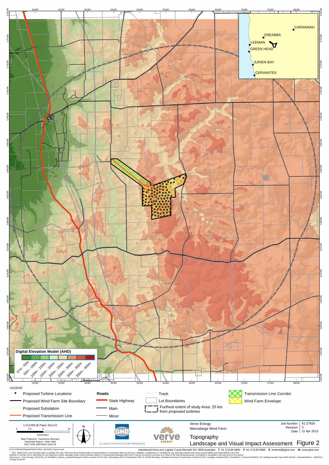
330,000
330,000
335,000
335,000
340,000
340,000
345,000
345,000
350,000
350,000
355,000
355,000
360,000
360,000
365,000
365,000
370,000
370,000
375,000
375,000
380,000
380,000
6,650
,000
6,650
,000
6,655
,000
6,655
,000
6,660
,000
6,660
,000
6,665
,000
6,665
,000
6,670
,000
6,670
,000
6,675
,000
6,675
,000
6,680
,000
6,680
,000
6,685
,000
6,685
,000
6,690
,000
6,690
,000
6,695
,000
6,695
,000
6,700
,000
6,700
,000
6,705
,000
6,705
,000
6,710
,000
6,710
,000
6,715
,000
6,715
,000
6,720
,000
6,720
,000
G:\61\27826\GIS\Maps\MXD\6127826_20120228_Figure2.mxd
0 5 102.5
Kilometers
Map Projection: Transverse MercatorHorizontal Datum: GDA 1994Grid: GDA 1994 MGA Zone 50 o
' 2012. Whilst every care has been taken to prepare this map, GHD and Verve Energy make no representations or warranties about its accuracy, reliability, completeness or suitability for any particular purpose and cannot accept liability and responsibility of any kind (whether in contract, tort or otherwise) for any expenses, losses, damages and/or costs (including indirect or consequential damage) which are or may be incurred by any party as a result of the map being inaccurate, incomplete or unsuitable in any way and for any reason.
Verve EnergyWarradarge Wind Farm
TopographyFigure 2
Job NumberRevision C
61-27826
11 Apr 2012
Landscape and Visual Impact Assessment
Date
Data source: Verve Energy, 20120130_VV-3430909v1_turbine_Location/Proposed Turbine Location /03-02-2012, Warradarge Plan for Distribution GHD JC V2/Site Bounday, Substation,Proposed Transmission Line/01-02-2012. Landgate, Cadaster/2012, Roads/2012, Contours10m/2012. GA: NatMap Geodata Topo 250K Series3 - PopulatedPlaces - 20060713.Created by:lfarrell
Hazelwood Drive (cnr Lignite Court) Morwell VIC 3840 Australia T 61 3 5136 5800 F 61 3 5136 5888 E [email protected] W www.ghd.com
1:212,000 @ Paper Size A3
LEEMAN
ENEABBA
CARNAMAH
CERVANTES
JURIEN BAY
GREEN HEAD
LEGEND
Roads
Lot BoundariesProposed Wind Farm Site Boundary
Digital Elevation Model (AHD)
37m - 5
0m
50m - 1
00m
100m
- 150
m
150m
- 200
m
200m
- 250
m
250m
- 300
m
300m
- 350
m
350m
- 400
m
TrackProposed Turbine Locations
State Highway
Main
Proposed Transmission Line Minor
Proposed Substation Furthest extent of study Area: 25 kmfrom proposed turbines
Transmission Line Corridor
Wind Farm Envelope

61/27826/207081 Warradarge Windfarm Landscape and Visual Impact Assessment
Figure 3 Photomontages Locations

(!
(!
(!
(!
(!
(!
(!
View location 4 /Photomontage 4
View location 3 /Photomontage 3View location 6 /
Photomontage 6
View location 1 /Photomontage 1
View location 7 /Photomontage 7
View location 2 /Photomontage 2
View location 5 /Photomontage 5
RO
SE THO
MSO
N R
OA
D
GA
RIB
ALD
I WILLIS R
OA
D
CH
ATFIELD C
LAR
KE R
OA
D
TOOTBARDI ROAD
CARNAMAH - ENEABBA ROAD
COOROW - GREEN HEAD ROAD
BRAND HIGHW
AY
WILLMOTT ROAD
HUGHES ROAD
MARCHAGEE ROAD
ENEABBA - THREE SPRINGS ROAD
Lesueur National Park
Coomallo Nature Reserve
Wotto Nature Reserve
Alexander Morrison National Park
2728/390
330,000
330,000
335,000
335,000
340,000
340,000
345,000
345,000
350,000
350,000
355,000
355,000
360,000
360,000
365,000
365,000
370,000
370,000
375,000
375,000
380,000
380,000
6,650
,000
6,650
,000
6,655
,000
6,655
,000
6,660
,000
6,660
,000
6,665
,000
6,665
,000
6,670
,000
6,670
,000
6,675
,000
6,675
,000
6,680
,000
6,680
,000
6,685
,000
6,685
,000
6,690
,000
6,690
,000
6,695
,000
6,695
,000
6,700
,000
6,700
,000
6,705
,000
6,705
,000
6,710
,000
6,710
,000
6,715
,000
6,715
,000
6,720
,000
6,720
,000
G:\61\27826\GIS\Maps\MXD\6127826_20120228_Figure3_RevC.mxd
LEGEND
0 5 102.5
Kilometers
Map Projection: Transverse MercatorHorizontal Datum: GDA 1994Grid: GDA 1994 MGA Zone 50 o
' 2012. Whilst every care has been taken to prepare this map, GHD, Verve Energy and Landgate make no representations or warranties about its accuracy, reliability, completeness or suitability for any particular purpose and cannot accept liability and responsibility of any kind (whether in contract, tort or otherwise) for any expenses, losses, damages and/or costs (including indirect or consequential damage) which are or may be incurred by any party as a result of the map being inaccurate, incomplete or unsuitable in any way and for any reason.
Verve EnergyWarradarge Wind Farm
View and Photomontage LocationsFigure 3
Job NumberRevision G
61-27826
11 Apr 2012Date
Data source: Verve Energy, 20120130_VV-3430909v1_turbine_Location/Proposed Turbine Location /03-02-2012, Warradarge Plan for Distribution GHD JC V2/Site Bounday, Substation,Proposed Transmission Line/01-02-2012. GHD, 20120214_ProposedPhotomontageLocation/Photomontage Locations/28-02-2012. Landgate, Cadaster/2012, Roads/2012, Contours10m/2012. DEC: ManagedLandandWater/DEC07. GA: NatMap Geodata Topo 250K Series3 - PopulatedPlaces - 20060713. Created by:lfarrell
180 Lonsdale Street, Melbourne VIC 3000, Australia T 61 3 8687 0000 F 61 3 8687 8111 E [email protected] W www.ghd.com
1:212,000 @ Paper Size A3
LEEMAN
ENEABBA
CARNAMAH
CERVANTES
JURIEN BAY
GREEN HEAD
Landscape and Visual Impact Assessment
Lot Boundaries
Transmission Line Corridor
Wind Farm Envelope
Water Course
National ParkNature Reserve
Water Course Area
Roads
Main
State Highway
Minor
Track
Proposed Turbine Locations
Proposed Wind Farm Site Boundary
Proposed Substation
Proposed Transmission Line Photomontage Location and Direction
(!
Furthest extent of study Area: 25 km from proposed turbines

61/27826/207081 Warradarge Windfarm Landscape and Visual Impact Assessment
Figure 4 Landscape Character Map

(!
(!
(!
(!
(!
(!
(!
LCU3 - Natural Areas
LCU2 - Upper Western Gingin Plateau
LCU3 - Natural Areas
LCU3 - Natural Areas
LCU3 - Natural Areas
LCU3 - Natural Areas
View location 2 / Photomontage 2
View location 6 / Photomontage 6
View location 5 / Photomontage 5
View location 3 / Photomontage 3
View location 1 / Photomontage 1
View location 7 / Photomontage 7
View location 4 / Photomontage 4
330,000
330,000
335,000
335,000
340,000
340,000
345,000
345,000
350,000
350,000
355,000
355,000
360,000
360,000
365,000
365,000
370,000
370,000
375,000
375,000
380,000
380,0006,650
,000
6,650
,000
6,655
,000
6,655
,000
6,660
,000
6,660
,000
6,665
,000
6,665
,000
6,670
,000
6,670
,000
6,675
,000
6,675
,000
6,680
,000
6,680
,000
6,685
,000
6,685
,000
6,690
,000
6,690
,000
6,695
,000
6,695
,000
6,700
,000
6,700
,000
6,705
,000
6,705
,000
6,710
,000
6,710
,000
6,715
,000
6,715
,000
6,720
,000
6,720
,000
G:\61\27826\GIS\Maps\MXD\6127826_20120228_Figure4.mxd
0 5 102.5
KilometersMap Projection: Transverse Mercator
Horizontal Datum: GDA 1994Grid: GDA 1994 MGA Zone 50 o
' 2012. Whilst every care has been taken to prepare this map, GHD (and DATA CUSTODIAN) make no representations or warranties about its accuracy, reliability, completeness or suitability for any particular purpose and cannot accept liability and responsibility of any kind (whether in contract, tort or otherwise) for any expenses, losses, damages and/or costs (including indirect or consequential damage) which are or may be incurred by any party as a result of the map being inaccurate, incomplete or unsuitable in any way and for any reason.
Verve EnergyWarradarge Wind Farm
Landscape Character Units (LCU)Figure 4
Job NumberRevision D
61-27826
11 Apr 2012Date
Data source: Verve Energy: 20120130_VV-3430909v1_turbine_Location/Proposed Turbine Location /03-02-2012, Warradarge Plan for Distribution GHD JC V2/Site Bounday, Substation,Proposed Transmission Line/01-02-2012. GHD: Landscape Character Areas/02-2012 . Landgate, Cadaster/2012, Roads/2012, Contours10m/2012. DEC: ManagedLandandWater/DEC07. GA: NatMap Geodata Topo 250K Series3 - PopulatedPlaces - 20060713. Created by:lfarrell
180 Lonsdale Street, Melbourne VIC 3000, Australia T 61 3 8687 0000 F 61 3 8687 8111 E [email protected] W www.ghd.com
212,000 @ Paper Size A3
LEEMAN
ENEABBA
CARNAMAH
CERVANTES
JURIEN BAY
GREEN HEAD
LEGEND
Landscape Character Units
Roads
Main
State Highway
Minor
Track
Furthest extent of study Area: 25 kmfrom proposed turbines
Proposed Transmission Line
Proposed Turbine Locations
Proposed Wind Farm Site Boundary
Proposed Substation
Landscape and Visual Impact Assessment
LCU2 - Upper Western Gingin Plateau
LCU1 - Lower Western Edge and Plateau of the Gingin Scarp
Photomontage Location and Direction
(!
LCU3 - Natural Areas
Transmission Line Corridor
Wind Farm Envelope

61/27826/207081 Warradarge Windfarm Landscape and Visual Impact Assessment
Figure 5 Zone of Theoretical Visibility - 100m Hub Height
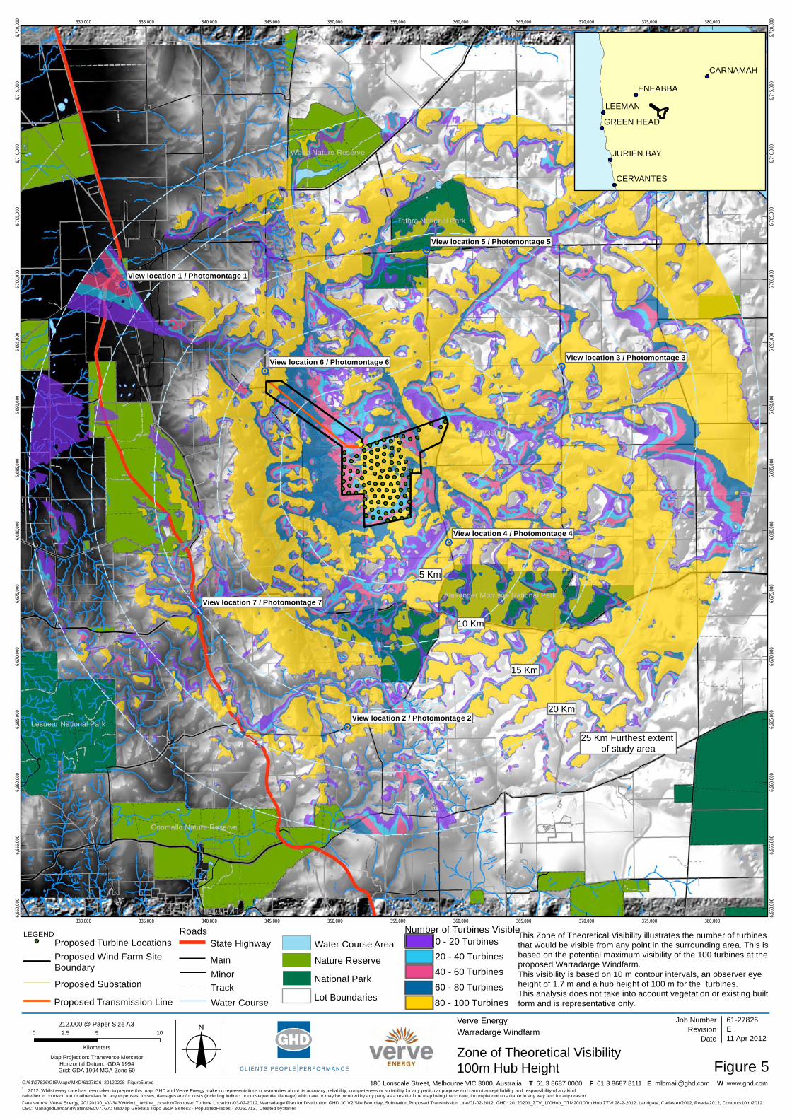
(!
(!
(!
(!
(!
(!
(!
25 Km Furthest extent of study area
5 Km
10 Km
15 Km
20 KmView location 2 / Photomontage 2
View location 6 / Photomontage 6
View location 5 / Photomontage 5
View location 3 / Photomontage 3
View location 1 / Photomontage 1
View location 7 / Photomontage 7
View location 4 / Photomontage 4
Lesueur National Park
Coomallo Nature Reserve
Tathra National Park
Wotto Nature Reserve
Alexander Morrison National Park
2728/390
330,000
330,000
335,000
335,000
340,000
340,000
345,000
345,000
350,000
350,000
355,000
355,000
360,000
360,000
365,000
365,000
370,000
370,000
375,000
375,000
380,000
380,000
6,650
,000
6,650
,000
6,655
,000
6,655
,000
6,660
,000
6,660
,000
6,665
,000
6,665
,000
6,670
,000
6,670
,000
6,675
,000
6,675
,000
6,680
,000
6,680
,000
6,685
,000
6,685
,000
6,690
,000
6,690
,000
6,695
,000
6,695
,000
6,700
,000
6,700
,000
6,705
,000
6,705
,000
6,710
,000
6,710
,000
6,715
,000
6,715
,000
6,720
,000
6,720
,000
G:\61\27826\GIS\Maps\MXD\6127826_20120228_Figure5.mxd
LEGEND
0 5 102.5
Kilometers
Map Projection: Transverse MercatorHorizontal Datum: GDA 1994Grid: GDA 1994 MGA Zone 50 o
' 2012. Whilst every care has been taken to prepare this map, GHD and Verve Energy make no representations or warranties about its accuracy, reliability, completeness or suitability for any particular purpose and cannot accept liability and responsibility of any kind (whether in contract, tort or otherwise) for any expenses, losses, damages and/or costs (including indirect or consequential damage) which are or may be incurred by any party as a result of the map being inaccurate, incomplete or unsuitable in any way and for any reason.
Verve EnergyWarradarge Windfarm
Zone of Theoretical VisibilityFigure 5
Job NumberRevision E
61-27826
11 Apr 2012
100m Hub Height
Date
Data source: Verve Energy, 20120130_VV-3430909v1_turbine_Location/Proposed Turbine Location /03-02-2012, Warradarge Plan for Distribution GHD JC V2/Site Bounday, Substation,Proposed Transmission Line/01-02-2012. GHD: 20120201_ZTV_100Hub_DTM20/100m Hub ZTV/ 28-2-2012. Landgate, Cadaster/2012, Roads/2012, Contours10m/2012. DEC: ManagedLandandWater/DEC07. GA: NatMap Geodata Topo 250K Series3 - PopulatedPlaces - 20060713. Created by:lfarrell
180 Lonsdale Street, Melbourne VIC 3000, Australia T 61 3 8687 0000 F 61 3 8687 8111 E [email protected] W www.ghd.com
212,000 @ Paper Size A3
LEEMAN
ENEABBA
CARNAMAH
CERVANTES
JURIEN BAY
GREEN HEAD
This Zone of Theoretical Visibility illustrates the number of turbinesthat would be visible from any point in the surrounding area. This is based on the potential maximum visibility of the 100 turbines at theproposed Warradarge Windfarm.This visibility is based on 10 m contour intervals, an observer eyeheight of 1.7 m and a hub height of 100 m for the turbines.This analysis does not take into account vegetation or existing builtform and is representative only.
Roads
Main
State Highway
MinorTrackWater Course
Water Course Area
Nature Reserve
Lot Boundaries
National Park
Number of Turbines Visible0 - 20 Turbines20 - 40 Turbines40 - 60 Turbines
60 - 80 Turbines
80 - 100 Turbines
Proposed Substation
Proposed Turbine Locations
Proposed Transmission Line
Proposed Wind Farm Site Boundary

61/27826/207081 Warradarge Windfarm Landscape and Visual Impact Assessment
Figure 6 Zone of Theoretical Visibility - 152m Tip Height

(!
(!
(!
(!
(!
(!
(!
5 Km
20 Km
15 Km
10 Km
25 Km Furthest extent of study area
View location 2 / Photomontage 2
View location 6 / Photomontage 6
View location 5 / Photomontage 5
View location 3 / Photomontage 3
View location 1 / Photomontage 1
View location 7 / Photomontage 7
View location 4 / Photomontage 4
Lesueur National Park
Coomallo Nature Reserve
Tathra National Park
Wotto Nature Reserve
Alexander Morrison National Park
2728/390
330,000
330,000
335,000
335,000
340,000
340,000
345,000
345,000
350,000
350,000
355,000
355,000
360,000
360,000
365,000
365,000
370,000
370,000
375,000
375,000
380,000
380,000
6,650
,000
6,650
,000
6,655
,000
6,655
,000
6,660
,000
6,660
,000
6,665
,000
6,665
,000
6,670
,000
6,670
,000
6,675
,000
6,675
,000
6,680
,000
6,680
,000
6,685
,000
6,685
,000
6,690
,000
6,690
,000
6,695
,000
6,695
,000
6,700
,000
6,700
,000
6,705
,000
6,705
,000
6,710
,000
6,710
,000
6,715
,000
6,715
,000
6,720
,000
6,720
,000
G:\61\27826\GIS\Maps\MXD\6127826_20120309_Figure6_RevB.mxd
LEGEND
0 5 102.5
Kilometers
Map Projection: Transverse MercatorHorizontal Datum: GDA 1994Grid: GDA 1994 MGA Zone 50 o
' 2012. Whilst every care has been taken to prepare this map, GHD and Verve Energy make no representations or warranties about its accuracy, reliability, completeness or suitability for any particular purpose and cannot accept liability and responsibility of any kind (whether in contract, tort or otherwise) for any expenses, losses, damages and/or costs (including indirect or consequential damage) which are or may be incurred by any party as a result of the map being inaccurate, incomplete or unsuitable in any way and for any reason.
Verve EnergyWarradarge Windfarm
Zone of Theoretical VisibilityFigure 6
Job NumberRevision E
61-27826
11 Apr 2012
152m Tip Height
Date
Data source: Verve Energy, 20120130_VV-3430909v1_turbine_Location/Proposed Turbine Location /03-02-2012, Warradarge Plan for Distribution GHD JC V2/Site Bounday, Substation,Proposed Transmission Line/01-02-2012. GHD: 20120229_ZTV_Warradarge_TIP152M_30km_DTM20/ 152m ZTV/ 28-2-2012. Landgate, Cadaster/2012, Roads/2012,Contours10m/2012. DEC: ManagedLandandWater/DEC07. GA: NatMap Geodata Topo 250K Series3 - PopulatedPlaces - 20060713. Created by:lfarrell
180 Lonsdale Street, Melbourne VIC 3000, Australia T 61 3 8687 0000 F 61 3 8687 8111 E [email protected] W www.ghd.com
212,000 @ Paper Size A3
LEEMAN
ENEABBA
CARNAMAH
CERVANTES
JURIEN BAY
GREEN HEAD
This Zone of Theoretical Visibility illustrates the number of turbinesthat would be visible from any point in the surrounding area. This is based on the potential maximum visibility of the 100 turbines at theproposed Warradarge Windfarm.This visibility is based on 10 m contour intervals, an observer eyeheight of 1.7 m and a tip height of 152 m for the turbines.This analysis does not take into account vegetation or existing builtform and is representative only.
Roads
MainState Highway
MinorTrackWater Course
Water Course Area
Nature Reserve
Lot Boundaries
National Park
Number of Turbines Visible0 - 20 Turbines20 - 40 Turbines40 - 60 Turbines
60 - 80 Turbines
80 - 100 TurbinesProposed Transmission LineProposed Substation
Proposed Turbine LocationsProposed Wind Farm Site Boundary

61/27826/207081 Warradarge Windfarm Landscape and Visual Impact Assessment
Figure 7 Cumulative Impact - Tip Height

25 Km
25 Km
25 Km
SHIRE OF DANDARAGAN
SHIRE OF COOROW
SHIRE OFCARNAMAH
SHIRE OF THREE SPRINGSSHIRE OF IRWIN
LEEMAN
ENEABBA
CERVANTES
JURIEN BAY
GREEN HEAD
300,000
300,000
305,000
305,000
310,000
310,000
315,000
315,000
320,000
320,000
325,000
325,000
330,000
330,000
335,000
335,000
340,000
340,000
345,000
345,000
350,000
350,000
355,000
355,000
360,000
360,000
365,000
365,000
370,000
370,000
375,000
375,000
380,000
380,000
6,615
,000
6,615
,000
6,620
,000
6,620
,000
6,625
,000
6,625
,000
6,630
,000
6,630
,000
6,635
,000
6,635
,000
6,640
,000
6,640
,000
6,645
,000
6,645
,000
6,650
,000
6,650
,000
6,655
,000
6,655
,000
6,660
,000
6,660
,000
6,665
,000
6,665
,000
6,670
,000
6,670
,000
6,675
,000
6,675
,000
6,680
,000
6,680
,000
6,685
,000
6,685
,000
6,690
,000
6,690
,000
6,695
,000
6,695
,000
6,700
,000
6,700
,000
6,705
,000
6,705
,000
6,710
,000
6,710
,000
G:\61\27826\GIS\Maps\MXD\6127826_20120228_Figure7.mxd
LEGEND
0 7.5 153.75
Kilometers
Map Projection: Transverse MercatorHorizontal Datum: GDA 1994Grid: GDA 1994 MGA Zone 50 o
' 2012. Whilst every care has been taken to prepare this map, GHD and Verve Energy make no representations or warranties about its accuracy, reliability, completeness or suitability for any particular purpose and cannot accept liability and responsibility of any kind (whether in contract, tort or otherwise) for any expenses, losses, damages and/or costs (including indirect or consequential damage) which are or may be incurred by any party as a result of the map being inaccurate, incomplete or unsuitable in any way and for any reason.
Verve EnergyWarradarge Windfarm
Cumulative Impact - Tip HeightFigure 7
Job NumberRevision D
61-27826
11 Apr 2012Date
Data source: Verve Energy: 20120130_VV-3430909v1_turbine_Location/Proposed Turbine Location /03-02-2012, Warradarge Plan for Distribution GHD JC V2/Site Bounday, Substation,Proposed Transmission Line/01-02-2012. GHD: Emu& Badgingarra Windfarm Locations/Badgingarra Wind Farm Landscape and Visual Impact Study,REpower, Final Report/2008. ESRI: SRTM Hill Shade Relief/2009. Landgate: Local Government Areas/2012. GA: NatMap Geodata Topo 250K Series3 - PopulatedPlaces - 20060713. Created by:lfarrell
180 Lonsdale Street, Melbourne VIC 3000, Australia T 61 3 8687 0000 F 61 3 8687 8111 E [email protected] W www.ghd.com
310,000 @ Paper Size A3
LEEMAN
ENEABBA
CARNAMAH
CERVANTES
JURIEN BAY
GREEN HEAD
This Zone of Theoretical Visibility illustrates the potential visibilityof the 100 turbines at the proposed Warradarge Windfarm and the65 turbines at Badgingarra Windfarm that may be visible from anypoint in the surrounding area.This visibility is based on 10 m contour intervals, an observer eyeheight of 1.7 m. A tip height of 152 m for Warradarge Windfarm and121 m for Badgingarra Windfarm were use for the assessment.This analysis does not take into account vegetation or existing builtform and is representative only.
Furthest extent of cumulative impact study area: 25 Km from Turbines
Local Government AreasEmu Downs Windfarm Proposed Warradarge Windfarm
Constructed Turbine Locations
Landscape and Visual Impact Assessment
Proposed Substation
Proposed Turbine Locations
Proposed Transmission Line
Zone of Theoretical Visibility
Proposed Turbine Locations
Zone of Theoretical Visibility
Proposed Badgingarra Windfarm Proposed Wind Farm Site Boundary

61/27826/207081 Warradarge Windfarm Landscape and Visual Impact Assessment
Appendix B
Photomontages

This Drawing must not beused for Construction unlesssigned as Approved
Date
CheckDrafting
DateDrawnRevisionNo
Check
DesignerDrawn
Scale
Design
Conditions of Use.This document may only be used by GHD's client (and any other person who GHD has agreed can use this document) for the purpose for which it wasprepared and must not be used by any other person or for any other purpose.
Note: * indicates signatures on original issue of drawing orlast revision of drawing
CLIENTS PEOPLE PERFORMANCE
Level 8, 180 Lonsdale Street, Melbourne VIC 3000 AustraliaT 61 3 8687 8000 F 61 3 8687 8111E [email protected] W www.ghd.com
(Project Director)Approved
JobManager
ProjectDirector
A2Original Size
Title
Project
Client Verve EnergyWarradarge Wind Farm
PhotomontageLocation 01
61-27826-SK001
A AL MC SG 29.02.12Issue for Information
Viewpoint Location: 1333058.3 E 6700073.31 N(UTM WG S84 Zone 50)Elevation of camera: 114.49 mOrientation of view: 143ºHorizontal field of view: 124ºVertical field of view: 55 ºHub height of turbines: 100mBlade length of turbines: 52mApproximate distance to nearest turbine: 22113mRecommended viewing distance: 425 mm
A.Lorenzon Verve Energy
M. Coyle
DO NOT SCALE
Verve Energy
Final Issue
Printed Date: 17.03.12 Printed by: Aline Lorenzon G:\61\27826\CADD\Visualisation\Photomontages
D
B
C
AL
AL
MC
MC
SG
SG
02.03.12
19.03.12
Issue for Information
Final Issue
Photo
Photomontage
3D model camera view
Wind Turbines not visible
D AL MC SG 20.03.12Final Issue amended
E AL MC SG 22.03.12Final Issue amended
(!G
AR
IBA
LDI W
ILLIS RO
AD
Photomontage 1
RO
SE THO
MSO
N R
OA
D
COOROW
BRANWI
Tathra National Park
(!Photomontage 6
RO
SE THO
MSO
N R
OA
D
GA
RIB
ALD
I WILLIS R
OA
D
COOROW - GREEN HEAD ROAD
WILLMOTT ROAD
2728/390
Alexander Morrison National Park
(!Photomontage 5
RO
SE THO
MSO
N R
OA
D
GA
RIB
ALD
I WILLIS R
OA
D
CARNAMAH
WILLMOTT ROAD
Tathra National Park
2728/390
(!Photomontage 3
RO
SE THO
MSO
N R
OA
D
GA
RIB
ALD
I WILLIS R
OA
D
CH
ATFIELD C
LAR
KE R
OA
D
COOROW - GREEN HEAD ROAD
WILLMOTT ROAD
Alexander Morrison National Park
2728/390
Tathra National Park
VIEW LOCATION
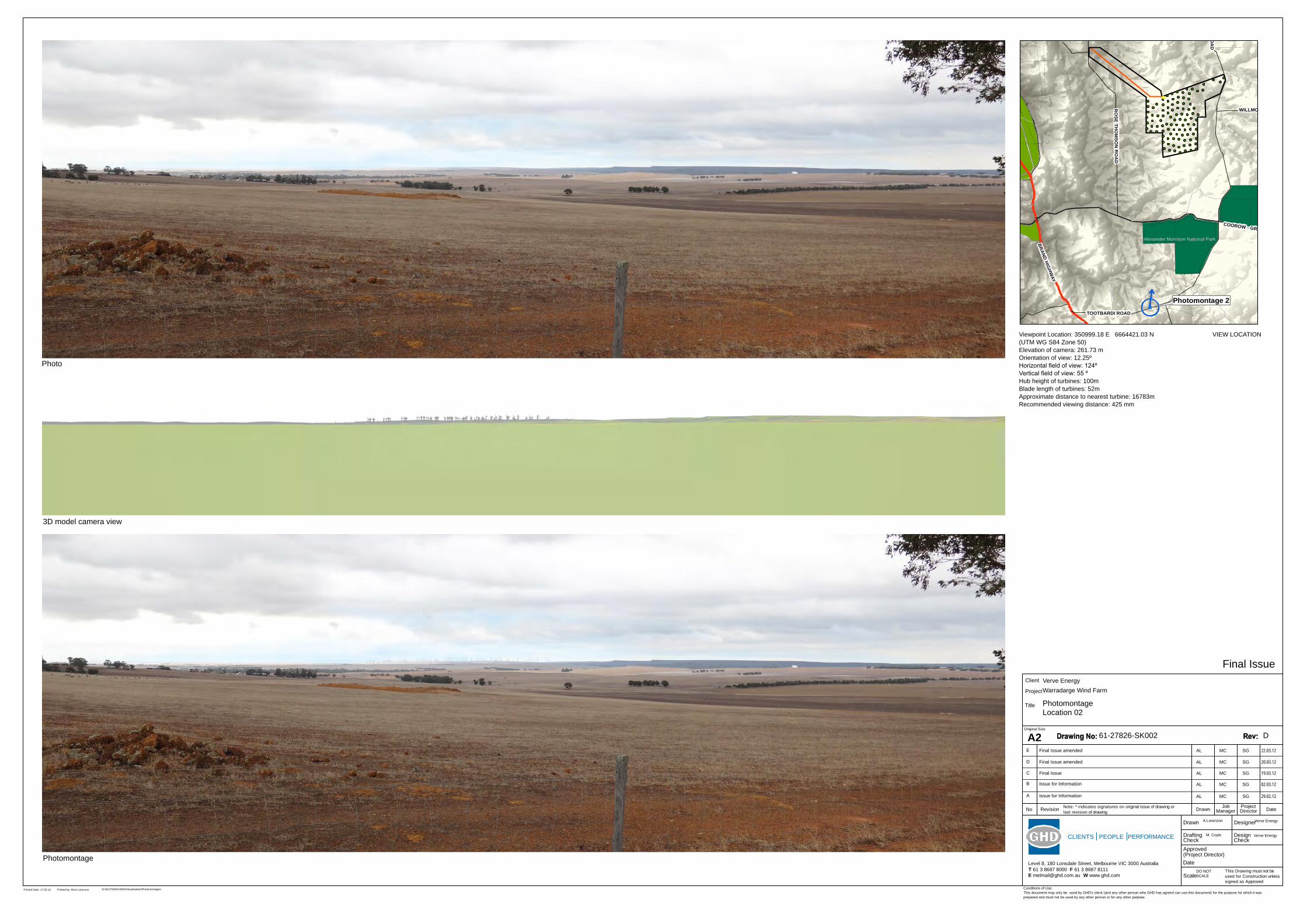
This Drawing must not beused for Construction unlesssigned as Approved
Date
CheckDrafting
DateDrawnRevisionNo
Check
DesignerDrawn
Scale
Design
Conditions of Use.This document may only be used by GHD's client (and any other person who GHD has agreed can use this document) for the purpose for which it wasprepared and must not be used by any other person or for any other purpose.
Note: * indicates signatures on original issue of drawing orlast revision of drawing
CLIENTS PEOPLE PERFORMANCE
Level 8, 180 Lonsdale Street, Melbourne VIC 3000 AustraliaT 61 3 8687 8000 F 61 3 8687 8111E [email protected] W www.ghd.com
(Project Director)Approved
JobManager
ProjectDirector
A2Original Size
Title
Project
Client Verve EnergyWarradarge Wind Farm
PhotomontageLocation 02
61-27826-SK002
A AL MC SG 29.02.12Issue for Information
Viewpoint Location: 350999.18 E 6664421.03 N(UTM WG S84 Zone 50)Elevation of camera: 261.73 mOrientation of view: 12.25ºHorizontal field of view: 124ºVertical field of view: 55 ºHub height of turbines: 100mBlade length of turbines: 52mApproximate distance to nearest turbine: 16783mRecommended viewing distance: 425 mm
A.Lorenzon Verve Energy
M. Coyle
DO NOT SCALE
Verve Energy
Final Issue
Printed Date: 17.03.12 Printed by: Aline Lorenzon G:\61\27826\CADD\Visualisation\Photomontages
B
C
AL
AL
MC
MC
SG
SG
02.03.12
19.03.12
Issue for Information
Final Issue
Photo
Photomontage
3D model camera view
D AL MC SG 20.03.12Final Issue amended
D
E AL MC SG 22.03.12Final Issue amended
(!
OA
D
Photomontage 2
RO
SE THO
MSO
N R
OA
D
TOOTBARDI ROAD
COOROW - GRE
BRAND HIGHW
AY
WILLMO
Alexander Morrison National Park
2728/390
(!Photomontage 7
RO
SE THO
MSO
N R
OA
D
GA
RIB
ALD
I WILLIS R
OA
D
COOROW
BRAND HI
W
Alexander Morrison National Park
VIEW LOCATION

This Drawing must not beused for Construction unlesssigned as Approved
Date
CheckDrafting
DateDrawnRevisionNo
Check
DesignerDrawn
Scale
Design
Conditions of Use.This document may only be used by GHD's client (and any other person who GHD has agreed can use this document) for the purpose for which it wasprepared and must not be used by any other person or for any other purpose.
Note: * indicates signatures on original issue of drawing orlast revision of drawing
CLIENTS PEOPLE PERFORMANCE
Level 8, 180 Lonsdale Street, Melbourne VIC 3000 AustraliaT 61 3 8687 8000 F 61 3 8687 8111E [email protected] W www.ghd.com
(Project Director)Approved
JobManager
ProjectDirector
A2Original Size
Title
Project
Client Verve EnergyWarradarge Wind Farm
PhotomontageLocation 03
61-27826-SK003
A AL MC SG 29.02.12Issue for Information
Viewpoint Location: 368029.51 E 6693094.81 N(UTM WG S84 Zone 50)Elevation of camera: 288.39 mOrientation of view: 231.25ºHorizontal field of view: 124ºVertical field of view: 55 ºHub height of turbines: 100mBlade length of turbines: 52mApproximate distance to nearest turbine: 10225mRecommended viewing distance: 425 mm
A.Lorenzon Verve Energy
M. Coyle
DO NOT SCALE
Verve Energy
Final Issue
Printed Date: 17.03.12 Printed by: Aline Lorenzon G:\61\27826\CADD\Visualisation\Photomontages
B
C
AL
AL
MC
MC
SG
SG
02.03.12
19.03.12
Issue for Information
Final Issue
Photo
Photomontage
3D model camera view
D AL MC SG 20.03.12Final Issue amended
D
E AL MC SG 22.03.12Final Issue amended
(Photomontage 4
RO
SE THO
MSO
N R
OA
D
GA
RIB
ALD
I WILLIS R
OA
D
COOROW - GREEN HEAD ROAD
WILLMOTT ROAD
2728/390
Alexander Morrison National Park
(!Photomontage 6
RO
SE THO
MSO
N R
OA
D
GA
RIB
ALD
I WILLIS R
OA
D
COOROW - GREEN HEAD ROAD
WILLMOTT ROAD
2728/390
Alexander Morrison National Park
(!Photomontage 5
RO
SE THO
MSO
N R
OA
D
GA
RIB
ALD
I WILLIS R
OA
D
CARNAMAH
WILLMOTT ROAD
Tathra National Park
2728/390
(!Photomontage 3
RO
SE THO
MSO
N R
OA
D
GA
RIB
ALD
I WILLIS R
OA
D
CH
ATFIELD C
LAR
KE R
OA
D
COOROW - GREEN HEAD ROAD
WILLMOTT ROAD
Alexander Morrison National Park
2728/390
Tathra National Park
VIEW LOCATION

This Drawing must not beused for Construction unlesssigned as Approved
Date
CheckDrafting
DateDrawnRevisionNo
Check
DesignerDrawn
Scale
Design
Conditions of Use.This document may only be used by GHD's client (and any other person who GHD has agreed can use this document) for the purpose for which it wasprepared and must not be used by any other person or for any other purpose.
Note: * indicates signatures on original issue of drawing orlast revision of drawing
CLIENTS PEOPLE PERFORMANCE
Level 8, 180 Lonsdale Street, Melbourne VIC 3000 AustraliaT 61 3 8687 8000 F 61 3 8687 8111E [email protected] W www.ghd.com
(Project Director)Approved
JobManager
ProjectDirector
A2Original Size
Title
Project
Client Verve EnergyWarradarge Wind Farm
PhotomontageLocation 04
61-27826-SK004
A AL MC SG 29.02.12Issue for Information
A.Lorenzon Verve Energy
M. Coyle
DO NOT SCALE
Verve Energy
Final Issue
Printed Date: 17.03.12 Printed by: Aline Lorenzon G:\61\27826\CADD\Visualisation\Photomontages
B
C
AL
AL
MC
MC
SG
SG
02.03.12
19.03.12
Issue for Information
Final Issue
Photo
Photomontage
3D model camera view
D AL MC SG 20.03.12Final Issue amended
D
E AL MC SG 22.03.12Final Issue amended
Viewpoint Location: 359046.42 E 6679096.98 N(UTM WG S84 Zone 50)Elevation of camera: 296.42 mOrientation of view: 312ºHorizontal field of view: 124ºVertical field of view: 55 ºHub height of turbines: 100mBlade length of turbines: 52mApproximate distance to nearest turbine: 3750mRecommended viewing distance: 425 mm
(Photomontage 4
RO
SE THO
MSO
N R
OA
D
GA
RIB
ALD
I WILLIS R
OA
D
COOROW - GREEN HEAD ROAD
WILLMOTT ROAD
2728/390
Alexander Morrison National Park
(!Photomontage 6
RO
SE THO
MSO
N R
OA
D
GA
RIB
ALD
I WILLIS R
OA
D
COOROW - GREEN HEAD ROAD
WILLMOTT ROAD
2728/390
Alexander Morrison National Park
(!Photomontage 5
RO
SE THO
MSO
N R
OA
D
GA
RIB
ALD
I WILLIS R
OA
D
CARNAMAH
WILLMOTT ROAD
Tathra National Park
2728/390
(!Photomontage 3
RO
SE THO
MSO
N R
OA
D
GA
RIB
ALD
I WILLIS R
OA
D
CH
ATFIELD C
LAR
KE R
OA
D
COOROW - GREEN HEAD ROAD
WILLMOTT ROAD
Alexander Morrison National Park
2728/390
Tathra National Park
VIEW LOCATION

This Drawing must not beused for Construction unlesssigned as Approved
Date
CheckDrafting
DateDrawnRevisionNo
Check
DesignerDrawn
Scale
Design
Conditions of Use.This document may only be used by GHD's client (and any other person who GHD has agreed can use this document) for the purpose for which it wasprepared and must not be used by any other person or for any other purpose.
Note: * indicates signatures on original issue of drawing orlast revision of drawing
CLIENTS PEOPLE PERFORMANCE
Level 8, 180 Lonsdale Street, Melbourne VIC 3000 AustraliaT 61 3 8687 8000 F 61 3 8687 8111E [email protected] W www.ghd.com
(Project Director)Approved
JobManager
ProjectDirector
A2Original Size
Title
Project
Client Verve EnergyWarradarge Wind Farm
PhotomontageLocation 05
61-27826-SK005
A AL MC SG 29.02.12Issue for Information
A.Lorenzon Verve Energy
M. Coyle
DO NOT SCALE
Verve Energy
Final Issue
Printed Date: 17.03.12 Printed by: Aline Lorenzon G:\61\27826\CADD\Visualisation\Photomontages
B
C
AL
AL
MC
MC
SG
SG
02.03.12
19.03.12
Issue for Information
Final Issue
Photo
Photomontage
3D model camera view
D AL MC SG 20.03.12Final Issue amended
D
E AL MC SG 22.03.12Final Issue amended
Viewpoint Location: 357300.34 E 6702318.48 N(UTM WG S84 Zone 50)Elevation of camera: 299.18 mOrientation of view: 184ºHorizontal field of view: 124ºVertical field of view: 55 ºHub height of turbines: 100mBlade length of turbines: 52mApproximate distance to nearest turbine: 13685mRecommended viewing distance: 425 mm
(Photomontage 4
RO
SE THO
MSO
N R
OA
D
GA
RIB
ALD
I WILLIS R
OA
D
COOROW - GREEN HEAD ROAD
WILLMOTT ROAD
2728/390
Alexander Morrison National Park
(!Photomontage 6
RO
SE THO
MSO
N R
OA
D
GA
RIB
ALD
I WILLIS R
OA
D
COOROW - GREEN HEAD ROAD
WILLMOTT ROAD
2728/390
Alexander Morrison National Park
(!Photomontage 5
RO
SE THO
MSO
N R
OA
D
GA
RIB
ALD
I WILLIS R
OA
D
CARNAMAH
WILLMOTT ROAD
Tathra National Park
2728/390
(!Photomontage 3
RO
SE THO
MSO
N R
OA
D
GA
RIB
ALD
I WILLIS R
OA
D
CH
ATFIELD C
LAR
KE R
OA
D
COOROW - GREEN HEAD ROAD
WILLMOTT ROAD
Alexander Morrison National Park
2728/390
Tathra National Park
VIEW LOCATION
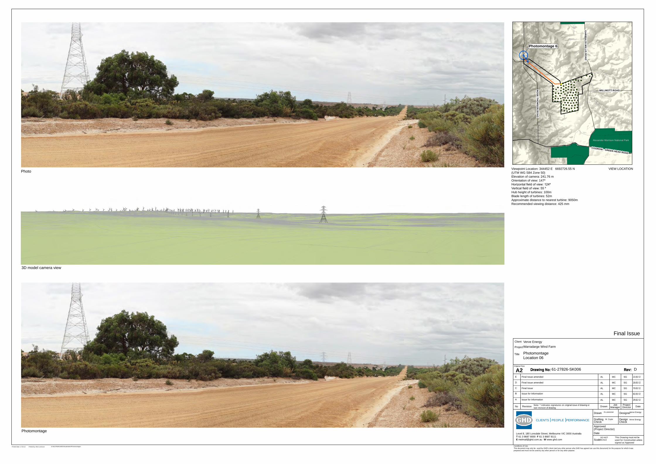
This Drawing must not beused for Construction unlesssigned as Approved
Date
CheckDrafting
DateDrawnRevisionNo
Check
DesignerDrawn
Scale
Design
Conditions of Use.This document may only be used by GHD's client (and any other person who GHD has agreed can use this document) for the purpose for which it wasprepared and must not be used by any other person or for any other purpose.
Note: * indicates signatures on original issue of drawing orlast revision of drawing
CLIENTS PEOPLE PERFORMANCE
Level 8, 180 Lonsdale Street, Melbourne VIC 3000 AustraliaT 61 3 8687 8000 F 61 3 8687 8111E [email protected] W www.ghd.com
(Project Director)Approved
JobManager
ProjectDirector
A2Original Size
Title
Project
Client Verve EnergyWarradarge Wind Farm
PhotomontageLocation 06
61-27826-SK006
A AL MC SG 29.02.12Issue for Information
A.Lorenzon Verve Energy
M. Coyle
DO NOT SCALE
Verve Energy
Final Issue
Printed Date: 17.03.12 Printed by: Aline Lorenzon G:\61\27826\CADD\Visualisation\Photomontages
B
C
AL
AL
MC
MC
SG
SG
02.03.12
19.03.12
Issue for Information
Final Issue
Photo
Photomontage
3D model camera view
D AL MC SG 20.03.12Final Issue amended
D
E AL MC SG 22.03.12Final Issue amended
Viewpoint Location: 344452 E 6692726.55 N(UTM WG S84 Zone 50)Elevation of camera: 241.76 mOrientation of view: 147ºHorizontal field of view: 124ºVertical field of view: 55 ºHub height of turbines: 100mBlade length of turbines: 52mApproximate distance to nearest turbine: 9050mRecommended viewing distance: 425 mm
(Photomontage 4
RO
SE THO
MSO
N R
OA
D
GA
RIB
ALD
I WILLIS R
OA
D
COOROW - GREEN HEAD ROAD
WILLMOTT ROAD
2728/390
Alexander Morrison National Park
(!Photomontage 6
RO
SE THO
MSO
N R
OA
D
GA
RIB
ALD
I WILLIS R
OA
D
COOROW - GREEN HEAD ROAD
WILLMOTT ROAD
2728/390
Alexander Morrison National Park
(!Photomontage 5
RO
SE THO
MSO
N R
OA
D
GA
RIB
ALD
I WILLIS R
OA
D
CARNAMAH
WILLMOTT ROAD
Tathra National Park
2728/390
(!Photomontage 3
RO
SE THO
MSO
N R
OA
D
GA
RIB
ALD
I WILLIS R
OA
D
CH
ATFIELD C
LAR
KE R
OA
D
COOROW - GREEN HEAD ROAD
WILLMOTT ROAD
Alexander Morrison National Park
2728/390
Tathra National Park
VIEW LOCATION

This Drawing must not beused for Construction unlesssigned as Approved
Date
CheckDrafting
DateDrawnRevisionNo
Check
DesignerDrawn
Scale
Design
Conditions of Use.This document may only be used by GHD's client (and any other person who GHD has agreed can use this document) for the purpose for which it wasprepared and must not be used by any other person or for any other purpose.
Note: * indicates signatures on original issue of drawing orlast revision of drawing
CLIENTS PEOPLE PERFORMANCE
Level 8, 180 Lonsdale Street, Melbourne VIC 3000 AustraliaT 61 3 8687 8000 F 61 3 8687 8111E [email protected] W www.ghd.com
(Project Director)Approved
JobManager
ProjectDirector
A2Original Size
Title
Project
Client Verve EnergyWarradarge Wind Farm
PhotomontageLocation 07
61-27826-SK007
A AL MC SG 29.02.12Issue for Information
A.Lorenzon Verve Energy
M. Coyle
DO NOT SCALE
Verve Energy
Final Issue
Printed Date: 17.03.12 Printed by: Aline Lorenzon G:\61\27826\CADD\Visualisation\Photomontages
B
C
D
E
AL
AL
AL
AL
MC
MC
MC
MC
SG
SG
SG
SG
02.03.12
19.03.12
20.03.12
22.03.12
Issue for Information
Final Issue
Final Issue amended
Final Issue amended
Photo
Photomontage
3D model camera view
Wind Turbines not visible
D
Viewpoint Location: 339115 E 6673629 N(UTM WG S84 Zone 50)Elevation of camera: 172 mOrientation of view: 34ºHorizontal field of view: 70ºVertical field of view: 55 ºHub height of turbines: 100mBlade length of turbines: 52mApproximate distance to nearest turbine: 15311mRecommended viewing distance: 425 mm
VIEW LOCATION
(!
OA
D
Photomontage 2
RO
SE THO
MSO
N R
OA
D
TOOTBARDI ROAD
COOROW - GRE
BRAND HIGHW
AY
WILLMO
Alexander Morrison National Park
2728/390
(!Photomontage 7
RO
SE THO
MSO
N R
OA
D
GA
RIB
ALD
I WILLIS R
OA
D
COOROW
BRAND HI
W
Alexander Morrison National Park
61/27826/207081 Warradarge Windfarm Landscape and Visual Impact Assessment
GHD
180 Lonsdale Street Melbourne, Victoria 3000 T: (03) 8687 8000 F: (03) 8687 8111 E: [email protected]
© GHD 2012
This document is and shall remain the property of GHD. The document may only be used for the purpose for which it was commissioned and in accordance with the Terms of Engagement for the commission. Unauthorised use of this document in any form whatsoever is prohibited.
Document Status
Rev No. Author
Reviewer Approved for Issue
Name Signature Name Signature Date
A Laura Farrell Kate Milburn Martin Coyle 29/2/12
B Laura Farrell/Kate Milburn
Martin Coyle Scott Graham 22/3/12
C Laura Farrell/Kate Milburn
Martin Coyle
Scott Graham
30/3/12
D Laura Farrell Martin Coyle
Scott Graham
18/4/12


